International Research Journal of Engineering and Technology (IRJET) e-ISSN:2395-0056
Volume: 12 Issue: 04 | Apr 2025 www.irjet.net p-ISSN:2395-0072


International Research Journal of Engineering and Technology (IRJET) e-ISSN:2395-0056
Volume: 12 Issue: 04 | Apr 2025 www.irjet.net p-ISSN:2395-0072
Mr. Saurabh Miri, Mr. Ashish Tamrakar
Student, Dept. of Computer Science & Engineering, Rungta College, Raipur, India
Associate Professor, Dept of Computer Science & Engineering, Rungta College, Raipur, India
***
Abstract -Globalecosystemsareseriouslythreatenedby deforestation, which also contributes to environmental degradation, biodiversity loss, and climate change. Mitigating these effects requires effective forest cover monitoring, and deforestation detection has been transformed by recent developments in forest image processing. Thisstudy examines the most recent methods usedintheanalysisofforestimages,withanemphasison change detection algorithms, artificial intelligence (AI), andremotesensingtechnologies.Itemphasizeshowdeep learning methods, such Convolutional Neural Networks (CNNs), can evaluate data from satellites and drones to accuratelyidentifychangesinforestcover.
Key Words: Deforestation detection , Forest image analysis, Remote sensing, Artificial intelligence (AI),Convolutional Neural Networks (CNNs) ,Satellite imagery.
One of the most urgent environmental problems of the twenty-first century is deforestation, or the extensive removalofforestcover.Becausetheyregulatetheclimate, protect biodiversity, and act as carbon sinks, forests are essential to sustaining ecological equilibrium. However, the world's forest loss has been greatly accelerated by logging, infrastructural development, urbanization, and agricultural expansion. The Food and Agriculture Organization (FAO) has recently reported that the world losesalmost10millionhectaresofforesteachyear,which significantly contributes to climate change and global carbonemissions.
Accurate, fast, and scalable techniques for identifying changes in forest cover are necessary for deforestation monitoring and mitigation. Even if they are dependable, traditional techniques like field surveys and manual mapping are frequently time-consuming, labor-intensive, and have limited spatial coverage. Because of this, there hasbeenanincreasingtrendtowardautomatedandsemiautomatic methods that take advantage of developments in artificial intelligence (AI), geographic information systems(GIS),andremotesensingtechnologies.Oneofthe most effective methods for identifying, measuring, and reportingdeforestationisthestudyofforestimages.
In order to detect changes in wooded areas, forest image analysis include processing and analyzing satellite pictures,aerial photos,and drone-captured images.These photosofferimportantinformationonchangesinlanduse, canopy density, and vegetation health. Researchers can identifyillicitloggingactivities,categorizeforestandnonforest regions, and track forest regenerationinitiatives by usingcomplexalgorithms.
2.1.AnalyzingNASASatelliteimagedatasettotrackforest cover change over one year. Kumar, R. R., Rani, N., Kajale, H. V., & Kaur, D. (2024). Indian Scientific Journal Of Research In Engineering And Management
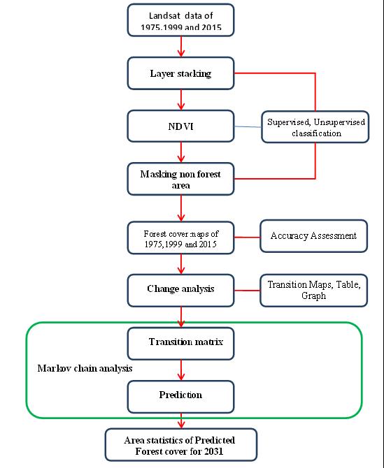
The purpose of this research article is to monitor and comprehendchangesinforestcoveroverthepastyear by analyzing the NASA satellite picture collection. A key environmental indicator, changes in forest cover have an impact on ecosystem services, biodiversity, and climate control. It draws attention to how well segmentation approaches work in a variety of forestry applications, including individual tree monitoring and accurate tree species identification. Improving ecological monitoring and forest inventory procedures depends on this contribution The review discusses the difficulties encountered when putting various segmentation strategies into practice, such as occlusions, overlapping branches, and inconsistent data quality. The report lays the groundwork for future research targeted at solving these challenges by recognizing them. Common machine learning techniques used in research concerning land cover classification and remote sensing because of its resilience and capacity to manage big datasets, Random ForestisfrequentlyUtilized.
Validation can also be accomplished by using statistical tests to examine the results' significance. This aids in determining if the changes that have been noticed are statistically significant or if they could have happened by accident. Using this method, the dataset is divided into subgroups, and the model is trained on some of these subsets while being validatedonothers.Evaluation of the results' generalizability to a different dataset is aided by cross-validation.

International Research Journal of Engineering and Technology (IRJET) e-ISSN:2395-0056
Volume: 12 Issue: 04 | Apr 2025 www.irjet.net p-ISSN:2395-0072

Fig-I:Flowchartoftheproposedsystem
2.2. Application of Image Analytics for Tree Enumeration for Diversion of Forest Land. Dukale, D.Agale,S.,Kaunge,S.,&Nikam,P.(2024).International Journal For Multidisciplinary Research.
This paper aims, particularly in development projects, precisetreeenumerationisessentialforresponsibleforest land diversion. In order to meet development objectives and limit environmental concerns, this accuracy is essential. It draws attention to the shortcomings of conventionalmanualsurveys,whicharefrequentlycostly, time-consuming, and prone to human error. These restrictions may make it more difficult to make prompt decisions about land use and conservation. The quality of satellite imagery and aerial photography is crucial to the efficacy of the suggested image analytics approach. Inaccuracies in tree counting and classification caused by poor image quality might not be addressed in the paper, cutting-edge image analytics technology that leverages satelliteimagesandaerialpicturesfortreeenumeration.
Byautomating thecounting procedure, whichiscurrently done by hand, this technology seeks to increase accuracy and efficiency. In tree enumeration, the techniques are intended to reduce false positives and negatives. The solution continuously exhibits great precision, which is essential for responsible forest land diversion, the paper highlights. By incorporating technology into ecological evaluations, this image analytics system creates new opportunities for environmental science study and application, and the findings indicate that it may lead to more improvements in forest management and conservationtechniques.Theimportanceofthesolutionin advancing ethical and sustainable land development methodsisemphasizedinthestudy.Thesystemoptimizes
resource allocation while reducing environmental effect by supplying fast and reliable data, which helps strike a balancebetweenecologicalpreservationanddevelopment needs.
D. S., Srija, P., Krishna,P.R.,Panchikkil,S.,&Manikandan,V.M.(2024).
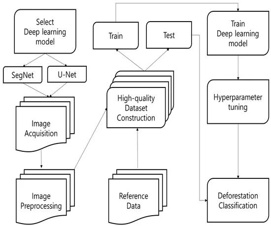
This paper emphasis on tracking deforestation is emphasized in the introduction because of its effects on ecosystem services, biodiversity, and climate change. It draws attention to the necessity of efficient instruments for monitoring alterations in forest cover over time. The study explains how remote sensing technology has become a potent tool for tracking and evaluating changes in land cover, especially in wooded regions. Large-scale monitoring requires a broad perspective, which remote sensing offers. combining data from remote sensing with machine learning methods. Better classification and analysis of satellite photos are made possible by this combination, which increases the precision and effectiveness of deforestation detection. purpose is to investigate and assessseveralmachinelearningtechniquesforidentifying deforestationinremotesensingphotos.Thegoalistoadd to the body of knowledge already in existence and offer workablewaysfortrackingthelossofforests.It'spossible thatnotallareasorkindsofwoodscanusetheresultsand approaches covered in this study. The success of the suggested solutions may be impacted by local environmental circumstances, land use patterns, and socioeconomic considerations, which would limit its generalizability.Thestudyprovidesinsightfulinformation for further study in the area by emphasizing the need of selecting suitable approaches according to particular requirements. It promotes more research into remote sensing methods and how they may be used to track deforestation, which is essential for successful environmental preservation initiatives. For researchers and practitioners engaged in land management and environmental monitoring, the study's conclusions offer usefulinsights

International Research Journal of Engineering and Technology (IRJET) e-ISSN:2395-0056
Volume: 12 Issue: 04 | Apr 2025 www.irjet.net p-ISSN:2395-0072

Fig-2:Workflowofdetectionsystem
2.4. Analysis of Image Processing In Forestry and Agriculture Review Mosslah,A.A.,&Abbas,A.H.(2023).
This paper aims of methods for using computer technologies to boost agricultural productivity have been shown. One technique is turning into a useful tool for image processing. This paper offers a succinct evaluation of the application of image processing in forestry and agriculture to assist scholars and farmers in enhancing agricultural practices. Image processing techniques are very useful for modern agricultural methods, insecticides and herbicides, plant nutrition management, and plant development monitoring. The significance of segmentation the process of splitting a picture into pixels that are plants and those that are not is emphasized in the paper. For additional analysis, such differentiating between weedsand crops, thisis essential. For intelligent agricultural applications, especially in herbicide application, effective segmentation is essential. Because color index approaches are so common in the literature, they are the main emphasis of this work. This methodefficientlyclassifiesplantsbyexaminingthecolor informationinphotos.

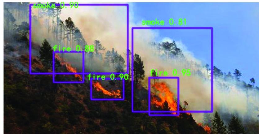
Fig-3:Stepbystepdetectionprocess
The paper summarizes the advantages of image processingincontemporaryfarmingmethods,makingita useful tool for scholars and farmers alike. It emphasizes how these technologies can enhance pest control, plant nutrition management, and overall agricultural productivity.Thestudyhighlightscurrentobstaclesinthe use of image processing in agriculture, including the requirement for segmentation methods to be more accurateandefficient.Additionally,ithighlightsprospects for future developments, promoting more study and improvementinthisfield.
The paper's focus on color index-based classification techniques is one of its main contributions. The study emphasizes the wealth of research on this subject from 2008 to 2021, demonstrating the development and efficacy of these techniques in agricultural settings. The study offers a comprehensive evaluation of several image processing methods that improve farming operations. In order to distinguish between plant and non-plant pixels and support efficient crop management, it primarily concentratesonsegmentationtechniques.
2.5. Research on Forest Fire Image Recognition Based on Improved YOLOv5.Qin,L.,Zhang,H.,Liu,T.,&Wang,T. (2024).
The paper focuses on accuracy of target recognition of earlyforestfirephotosiscrucial forthedevelopmentand use of YOLOv5-based forest fire image recognition in the fieldofforestfirepreventiontoday.Thisarticleaddresses the issue of low image recognition accuracy in the early stages of forest fires by proposing an enhanced YOLOv5

International Research Journal of Engineering and Technology (IRJET) e-ISSN:2395-0056
Volume: 12 Issue: 04 | Apr 2025 www.irjet.net p-ISSN:2395-0072
algorithm. This algorithm is based on the YOLOv5 backbone network and is designed to improve image recognition accuracy in the early stages of forest fires. A BotNET module was introduced to the backbone network's end. This module is intended to improve the network'sfeatureextractioncapabilitiesevenmore,which will help it detect subtle fire features more effectively. By addingCBAMandBotNET modules,thisworksuggestsan enhanced YOLOv5 algorithm for forest fire picture detection, which outperforms the original YOLOv5 in identifying small and unclear fire targets and improves accuracyintheearlyphases.
Future research can also concentrate on developing intuitive user interfaces for the enhanced detection system.Thiswouldensurethatthetechnologycanbeused efficiently in practice by making it easier for emergency responders and forest management teams to access and use. The study's practical significance for forest fire prevention efforts stem from its focus on early image recognitionofforestfires.Theenhancedalgorithmcan be applied in practical settings, helping forest management teamsbettermonitorandaddresspossiblefirehazards.

Better accuracy in identifying forest fires in their early stages is provided by the updated YOLOv5 algorithm. By enabling forest management teams to react swiftly to possible threats, this skill is essential for prompt action and can help stop small fires from growing into larger, uncontrollable wildfires. The algorithm can help ensure the safety of firefighters and neighboring communities by enhancingtheidentificationofforestfires.Earlydetection lowers the risk to property and human life in fire-prone areasbyenablingmoreefficientresourcedeployment.
Better resource allocation is made possible by the capacity to precisely identify fire dangers. By prioritizing high-risk regions, forest management teams may make sure that firefighting resources are deployed effectively and efficiently, which can reduce costs and improve fire control results. Potential integration with other technology, including drones or satellite imagery, is suggested by the research. In order to implement proactive fire management measures, this integration can
improve monitoring capabilities by offering a thorough pictureofforestconditionsandfirehazards.
2.6. Characterization and differentiation of forest species by seed image analysis: a new methodological approach Felix,F.,Kratz,D.,Ribeiro,R.,&Nogueira,A.C. (2023).
Thispaper focuses on forestspeciescan be identifiedand distinguished using biometric seed analysis. However, agricultural species are assessed using costly and frequentlyunavailabletechnology,whileforestspeciesare typically studied using manual methods such measurements with a digital caliper, which provides limited information on plant morphological traits. Therefore, the goal of the current study was to show that techniques for processing and analyzing seed images might aid in the characterization and differentiation of Brazilianforestspecies.
Field testing could evaluate the efficacy of the technique presented in this study in real-world situations. To evaluate the feasibility and accuracy of seed image processing in recognizing species in situ, future research couldapplyittootherforesthabitats.
Futureresearchcouldcombinetheanalysisofseedimages withothermorphologicaldata,suchleaforblossomtraits, even though the study's primary focus was on seed characteristics. This all-encompassing method might offer a more thorough comprehension of species identification anddifference.

Fig-5:Seedimageanalysis
Species with identical morphometric traits, especially thoseinthesamefamilyor genus, maybedifficultforthe techniquetodistinguishfromoneanother.Becauseofthis overlap, it could be difficult to correctly identify closely related species from seed photos alone. The study mostly

International Research Journal of Engineering and Technology (IRJET) e-ISSN:2395-0056
Volume: 12 Issue: 04 | Apr 2025 www.irjet.net p-ISSN:2395-0072
uses image analysis conducted in a lab. Since environmental influences may affect seed morphology, future study should incorporate field validation to ensure thattheobservedtraitsholdtrueinnaturalsettings.
Further research should concentrate on creating userfriendlysoftwareorprogramsthatenableresearchersand practitioners to quickly analyze seed photos and identify species without requiring a high level of technical competence,asthestudyshowsthepromiseofseedimage analysis.
2.7. Research on Forest Landscape based on Big data and CiteSpace Visualization Analysis Lin, X., Xu, H., & Dong,J.(2023).
ThestudycombinesdatafromtheCNKIandWanfangData Service platforms to analyze literature about the ecology of forest landscapes. To extract pertinent literature material, it uses the Scrapy framework and the Python programminglanguage.
The study extracts literary data using the Scrapy framework in a Python programming environment. Because this framework is made for web scraping, the researchers can efficiently collect pertinent articles from online databases. Knowledge maps are produced by the studyusingCiteSpacevisualanalysissoftware.Inorderto help discover research hotspots, significant authors, and the evolution of themes over time, this software was created especially for visualizing patterns and trends in scientificliterature.
The study focuses on life cycle evaluation, renewable energy, and lowering carbon emissions, among other topics. The study primarily moves through the following phases: low-carbon technology application, low-carbon technology theory, and low-carbon economic growth. The creation and use of low-carbon materials, low-carbon landscape research methodologies, and low-carbon landscape emission-reduction technologies are the main areasofresearch.Thisreportprovidesathoroughanalysis of the low-carbon landscape research process and suggests future research directions for low-carbon landscapes in urban development, including economic benefitassessments.

In order to serve as a reference for low-carbon landscape research, this study thoroughly examines the research processoflow-carbonlandscapesandproposesaresearch direction for low-carbon landscapes in future urban development, including economic benefit assessments, ecosystemrestorationandprotection,socialparticipation, andpolicysupport.
The papers under discussion offer a range of techniques for the detection and recognition phases. To get definite results, the detection phase has included techniques such as feature segmentation, form analysis, and image model conversion. Better results are obtained with edge detection and CNN classifier. Therefore, it is crucial to have strategies that yield better outcomes in order to accomplishtheobjectiveofhavingimageanalysissystems. Together, the referenced papers demonstrate how deep learning, remote sensing, and image analytics have advanced for environmental and forestry monitoring. Thesestudieshighlightthevitalimportanceoftechnology in sustainable forest management, from identifying fires and species distinction to assessing forest landscapes and detecting deforestation. Big data, machine learning, and imageprocessingarecombinedtoimproveenvironmental monitoring's precision and effectiveness, which supports improved conservation and decision-making. These technology advancements will be essential in -addressing environmental issues and advancing ecological sustainabilityasresearchadvances.
[1] Analyzing NASA Satellite image dataset to track forest cover change over one year. Kumar, R. R., Rani, N., Kajale, H. V., & Kaur, D. (2024). Indian Scientific Journal Of ResearchInEngineeringAndManagement.
[2] Dukale, D., Agale, S., Kaunge, S., & Nikam, P. (2024). Application of Image Analytics for Tree Enumeration for Diversion of Forest Land. International Journal For MultidisciplinaryResearch

International Research Journal of Engineering and Technology (IRJET) e-ISSN:2395-0056
Volume: 12 Issue: 04 | Apr 2025 www.irjet.net p-ISSN:2395-0072
[3] Deforestation Detection from Remote Sensing Images usingMachineLearning.Tharun,D.S.,Srija,P., Krishna,P. R.,Panchikkil,S.,&Manikandan,V.M.(2024).
[4] Analysis of Image Processing In Forestry and AgricultureReview.Mosslah,A.A.,&Abbas,A.H.(2023).
[5] Research on Forest Fire Image Recognition Based on Improved YOLOv5.Qin, L., Zhang, H., Liu, T., & Wang, T. (2024).
[6] Characterization and differentiation of forest species by seed image analysis: a new methodological approach. Felix,F.,Kratz,D.,Ribeiro,R.,&Nogueira,A.C.(2023).
[7] Research on Forest Landscape based on Big data and CiteSpace Visualization Analysis. Lin, X., Xu, H., & Dong, J. (2023).
2025, IRJET | Impact Factor value: 8.315 | ISO 9001:2008