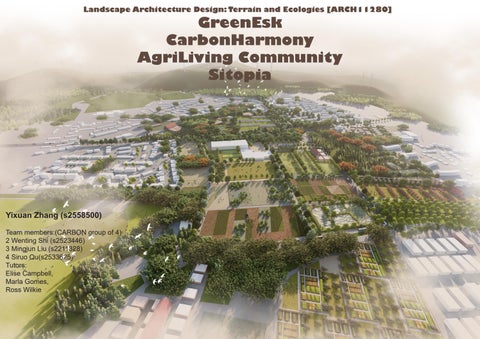
Yixuan Zhang (s2558500)
Team members:(CARBON group of 4)
2 Wenting Shi (s2523446)
3 Mingjun Liu (s2211328)
4 Siruo Qu(s2533625)
Tutors: Elise Campbell, Marla Gomes, Ross Wilkie
Yixuan Zhang (s2558500)
Team members:(CARBON group of 4)
2 Wenting Shi (s2523446)
3 Mingjun Liu (s2211328)
4 Siruo Qu(s2533625)
Tutors: Elise Campbell, Marla Gomes, Ross Wilkie
The 27 EU countries as a whole achieved a peak in carbon emissions in 1990, with peak emissions of 4.4 billion tons. Since then, total carbon dioxide emissions have begun to decline. In 2020, leaders of the 27 EU countries adopted the European Commission's recommendations on improving the mid-term goal of achieving carbon neutrality, planning to reduce European greenhouse gas emissions by 55% by 2030 and achieve carbon neutrality by 2050.
It can be seen that the control and planning of carbon emissions are crucial, and various regions and countries have begun plans to reduce emissions.
The Kyoto Protocol is the first legally binding document under the United Nations Framework Convention on Climate Change. It is also the first document in human history to limit greenhouse gas emissions in the form of regulations. It officially came into effect in February 2005.
Copenhagen Climate Change Conference: Environment ministers and other officials from 192 countries convened the United Nations Climate Conference in Copenhagen. This is another landmark global climate agreement after the "Kyoto Protocol". This is hailed as "the last chance to save mankind." s meeting.
The agreement, which will take effect within one year, aims to significantly reduce global greenhouse gas emissions, limit global temperature rise this century to less than 2°C, and seek measures to further limit temperature rise to less than 1.5°C. The Paris Agreement officially entered into force on November 4, 2016 and is a legally binding international treaty. Currently, a total of 194 Parties (193 countries plus the EU) are parties to the Paris Agreement.
Sweden has a carbon tax and Norway has a carbon tax
pioneered a carbon tax and Poland has a carbon tax.
Latvia has a carbon tax and Slovenia has a carbon tax
Carbon dioxide emissions (million metric tons)
Carbon dioxide emissions growth rate
Switzerland has a carbon tax and British Columbia has a carbon tax.
UK carbon price floor
Australia establishes carbon pricing mechanism.
Singapore has Carbon Tax, Chile has Carbon Tax, Colombia has Carbon Tax
Canada announces federal carbon price floor
France imposes carbon tax, Mexico imposes carbon tax, Australia abolishes carbon pricing mechanism
Ireland has a carbon tax, india clean environment tax
South Africa announces has carbon tax bill.
Portugal has carbon tax
Indonesia passes carbon tax bill
New Zealand raises carbon tax rate, Indonesia postpones carbon tax implementation
Climate Change Secretary Roseanna Cunningham said: "These statistics are hugely encouraging and show we have almost halved the greenhouse gases emitted in Scotland - underlining our role as an international leader in the fight against climate change. "We all have a role to play in that fight and I want to thank the households, communities and businesses who are working hard every day to reduce their own emissions. "But we must go further and faster if we are to meet our responsibilities to our children, grandchildren, and future generations.
Historical measures to control carbon emissions
1997 - UK Climate Commitment:
Commitment under the Kyoto Protocol to reduce emissions by 12.5% from 1990 levels by 2012, highlighting the UK's serious approach to climate change.
2009 - Climate Change Act: Legislation establishing stringent targets for reducing Scotland's carbon emissions by 2020 and 2050.
2014 - Creative
Carbon Scotland: An initiative to foster carbon emissions reporting and environmental stewardship within Scotland's arts sector.
2016 - Closure of Longannet Power Station: The shutdown significantly cut Scotland's carbon emissions, achieving the annual target set for that year.
2019 - Climate Change Act Amendment: Legislation passed to ensure the UK reaches net zero carbon emissions by 2050.
2021 - COP 26 UN
Climate Change Conference: A pivotal global summit in Glasgow, aiming to expedite actions under the Paris Agreement and UN climate framework
2022 - Scottish Net Zero Roadmap: A government-funded project to develop a decarbonization roadmap for Scotland's industrial sectors by 2040.
The trend of carbon dioxide emissions in Scotland has shown a significant downward trajectory across most sectors, with the largest reductions observed in the Energy Supply, Land Use, Land-Use Change, Forestry, Business, and Waste Management sectors. These sectors have benefited from robust policy measures, technological advancements, and shifts towards sustainable practices. However, emissions from International Shipping and Aviation have increased, presenting ongoing challenges.
1. The floodplain beside the reservoir is the most important part of wetland carbon sequestration. Protecting this area will not only increase carbon sequestration capacity, but also be beneficial to the ecological environment around the reservoir.
2. Artificial forests and artificially planted woods are used to facilitate the control of plant species within the site, but this can also easily have a negative impact on the natural succession of plants. 3.
2. The seaside green space is seriously eroded. It is very important for blue carbon. In the subsequent design, more efforts should be made to design this part.
2. Water and soil erosion is serious. In the later design, not only the goal of forest carbon sequestration must be considered, but also the water and soil issues within the site must be considered.
3. The estuary green space near the estuary enriches the plant levels of the green space, increases the blue carbon carbon sink capacity, and reduces the impact of urban sewage on water bodies.
1. There are many pastures, and excessive grazing has great damage to the ecological environment of the site itself.
2. Reasonable management of grazing and implementation of rotational grazing can also reduce carbon emissions from farms and pastures.
3. Water and soil erosion is serious, and ecological measures need to be taken to alleviate water and soil erosion while increasing plant species on the site to increase grassland carbon sinks.
1. If the water body is polluted, you can choose some plants in the design that can help with water body pollution and water carbon sequestration.
Built and Unbuilt Urban Areas
Traffic Systems
Bus Route and Cycle Path
Sites and Major Landscape Parks
Built and Unbuilt Urban Areas:To prepare for the subsequent construction of green and low-carbon communities, build more low-carbon buildings in unbuilt areas and add solar energy to established communities.
Traffic Systems & Bus Route and Cycle Path:Based on this, we will build low-carbon transportation routes and tourism routes, clarify existing transportation routes and add routes appropriately to form a more complete low-carbon network.
Historic Sites and Major Landscape Parks:Understand the historical conditions of the site from a high-level planning perspective and prepare for subsequent design of historical Landscape attractions. At the same time, it forms a complete tourism route with ecological Landscape attractions and low-carbon educational venues.
and
Industrial Parks and Coal Mining:Identify the locations of factories and industrial parks within the site. These parts are key areas of carbon emissions. If the carbon balance of the entire watershed is to be controlled, it is crucial to rationally transform and improve them.
Peatland Classification:Peatland is an important part of the site. Based on the grade and location of the peatland within the watershed, protection and restoration strategies are specified to increase the carbon sink capacity within the watershed and enhance the carbon sequestration capacity of the peatland.
Acid Soil Areas & Heather Grassland:Only by analyzing the soil properties and Heather can the strategy be reasonably set within the watershed.
Coniferous and Broadleaf Forests
Distribution Map
Agricultural and Pastoral Areas and High-quality Farms Distribution Map
Analyze data on the natural conditions of the site to help determine planning zoning boundaries and strategic distribution. The analysis of the flood situation fully demonstrates the importance of water on the site. When formulating strategies, it is necessary to design water to mitigate the negative impact of floods on the site and increase the carbon sink capacity of the water body.
Coastal Blue Carbon Areas
A vision for the future?
Committed to restoring blue carbon in the oceans of the region, making it Catchment's primary carbon offsetting zone, and using low-carbon methods to harmonious synergy between man and water.
The area is mainly composed of four parts, which are interwoven: Conventional Green Carbon Area, Conventional Blue Carbon Restoration Area (Algae), Other green areas fully utilizing water resources to increase carbon absorption, Areas utilizing low-carbon methods to address internal urban flooding issues.
Urban Carbon Reduction Areas (Six Areas)
A vision for the future?
We are committed to transforming the region into a series of low-carbon communities that can synchronize with water.
7.Paper Heritage Low Carbon Planning Area
8.Special Landscape Area
9.Flood Transformation Demonstration Area
10.Coal Heritage Low Carbon Planning Area
11.New Low Carbon Center
12.Transport Connection Area
Low-carbon Production Areas (Three Areas)
A vision for the future?
Committed to transforming this area into a non-spillover zone for carbon emissions, meaning that the generated carbon will not contribute to the overall carbon increase in the region.
4.New Energy Mining Area
5.Regenerative Agriculture Area
6.New Type Pasture Area
River Source and Carbon Sink Areas (Three Areas)
A vision for the future?
A commitment to the region to create carbon offsetting zones for the entire catchment.
1.Wilderness Ecological Conservation Area (Three Areas)
1a.Natural Restoration Area
1b.Ecological Grazing Area
1c.Peatland Conservation Area
2.Landscape Tourist Area (Two Areas)
2a.Natural Conservation Tourist Area
2b.A pasture Located on a Tributary of a River
3.Forest Ecological Conservation Area (Four Areas)
3a.Multilayered Natural Conservation Area
3b.Heyuan Bird Conservation Area
3c.Forest Peatland Conservation Area
3d.Natural Forestry Conservation Area
The green network is based on the valley protection area under Midlothian planning, extending the main riverways throughout the basin and the streams surrounding the riverway green areas. It connects forest protected areas within the site, ecological protected areas and forest areas, forming a green network that connected the four planning areas.
By analyzing existing roads, roads to be built, existing bus lines and bicycle routes based on low-carbon environmental and regional accessibility targets, we will add new bike routes and bus lines sites. At the same time, we will connect cultural sites, landscapes and educational centres inside the site to support cultural tourism. In addition, a low-carbon transport line could be formed that connects the Edinburgh and the musselburgh districts.
The site holds significant commercial value with a diverse range of assets, including commercial forestry areas, potential coal mining sites, extensive pastures, and farmlands. Operating on a self-sustaining business model, the site efficiently minimizes carbon emissions associated with transporting goods externally. Moreover, it can generate income through centralized transportation networks such as highways and railways, catering to nearby cities and even the entire United Kingdom.
The increase in internal revenue can potentially facilitate the closure or modernization of high-carbon-emission industries, consequently reducing carbon emissions across the entire region and promoting carbon neutrality.
The whole scenic area is designed around public rail transport, linking all the attractions in the scenic area to achieve the effect of low-carbon and environmentally friendly tourism, and setting up a number of education centres to popularise low-carbon and environmental protection knowledge to the public.
1a Natural Restoration Area:
Based on biodiversity protecting area, to protect, recover and expand pratland and to take advantage of grazing and grose to protect acidic land and grassland for protecting wilderness species and increase carbon sink.
1b Ecological Grazing Area:
Based on a kind of sustainable grazing and grose feeding, to use sustainable management to restore the vitality of the acidic soil in the site to protect wildness species meanwhile keep local livstock development.
1c Peatland Conservation Area:
Based on loads of important peatland, to reduce pastures so that it can protect and expand the local peatland to improve the carbon sink ability
1.
3.
3.
2&3&4. Add sphaghum moss
2&3&4.Drive water from river to peatland
5&6. Return other area to peatland
2a Natural Conservation Tourist Area:
Based on a nature reserve and National Important Gardens and Designed Landscapes, making it a major area that combines low-carbon environmental protection and sightseeing.
2b Tributary's Pasture Area:
Based on a large number of North Esk river streams in the region and large areas of agricultural land and pasture area, to be used as a farming experience area close to a natural tourist area.
3a Multilayered Natural Conservation Area:
Based on abundant water system and loads of peatland, The main focus is on the protection, restoration and expansion of peatland, the extension of natural reserves in the region, and the increase of plant species to form a mixed area of woodland, wetland and peatland.
3b Headwater Bird Conservation Area:
Based on reservoirs and bird reserves, to take advantage of different soil type to form diffent habitat for creatures, meanwhile to use a sustainble way to develope grazing area.
3c Forest Peatland Conseration Area:
Based on loads of peatland, to develop commercial woodland on peatland and aicidic land to gain benefits from here and create carbon sink, meanwhile maintain the habitat of grose.
3d Natural Forestry Conservation Area:
Based on two large natural forest protecting areas, to expand the area of forest restoration and form multi-layer ecosystems to create carbon sink.
4 New Energy Mining Area:
Based on a large potential mining area, a certain amount of pasture area and protecting area, to develop a kind of sustainable grazing way to reduce carbon emission. Meanwhile, to keep potential mining area for future by planting commercial woodland.
5 Regenerative Agriculture Area:
Based on the largest number of high quality agricultural lands, to increase use of new energy(water resources&wind resources) and develop modual permanant agriculture to reduce Carbon produced by agriculture.
6 New Type Pasture Area:
Based on the mixed situation about grazing area and farmland, to develop a kind of new model combing grazing and agriculture to create a kind of sustainable way to reduce carbon emmision.
For building:according to distance with river and whether conatructed or not
flood: according to different river bank
Based on a great deal of blue carbon resources and urban area texture, we plan to divide this area into four parts: the first one is blue carbon imrpovment area; the second one is recouvery area; the third one is green carbon improvment area; the last one is flood-preventing area.
This project was not implemented and was a student entry for a competition, located in North Carolina. For the esk river basin, there is a large area of peatland and it is an important part of carbon sequestration. Through this case, we can learn more about the means of peatland restoration and protection. Although it lacks operability to a certain extent, it does carbon sequestration. and measures to protect peatland are more intuitive and easy to understand. It will be of great help for subsequent design.
This project explored the unique ecological, historical, and cultural role of peatland in North Carolina, and examined restoration and design strategies for these sensitive landscapes.
This project identified three peatland contexts in NC for the implementation of restoration and design strategies: i) public access to conserved peatlands; ii) restoration of peatland drained for agriculture; iii) resilience and adaptation of rural towns built in and around peatlands.
After relocation, a riverfront park replaces the downtown business district. As other homes and businesses also relocate out of the floodplain, civicpark space expands, and restored peatland areas become publiclyaccessible nature parks and preserves.
Air-SeniorPhase(nodate)Air-Seniorphase|Scotland’senvironmentweb. Available at: https:// www.environment.gov.scot/educational-resources/get-learning-air/air-senior-phase/ (Accessed: 28 April 2024).
Batchelor, M. (no date) Forestrystrategy,ScottishForestry. Available at: https://forestry.gov.scot/ forestry-strategy (Accessed: 28 April 2024).
CarbonStorageandsequestrationbyhabitat2021(NERR094):IUCNUKPeatlandProgramme (2021)IUCNPeatlandProgramme. Available at: https://www.iucn-uk-peatlandprogramme.org/ news/carbon-storage-and-sequestration-habitat-2021-nerr094 (Accessed: 28 April 2024).
Cookies on the Digimap website (no date) Digimap. Available at: https://digimap.edina.ac.uk/ (Accessed: 28 April 2024).
County (no date) TheFourthStatisticalAccount.Available at: https://el4.org.uk/county/economy/ coal-industry-an-overview/recent-history/ (Accessed: 28 April 2024).
DistributionofblackgrouseacrosstheUK(2021)WhattheScienceSays. Available at: https:// www.whatthesciencesays.org/distribution-of-black-grouse-across-the-uk/ (Accessed: 28 April 2024).
EskMills(nodate)PenicuikPapermaking300thAnniversary-EskMills. Available at: http:// penicuikpapermaking.org/eskm.html (Accessed: 28 April 2024).
Floodmaps(nodate)Beta. Available at: https://beta.sepa.scot/flooding/flood-maps/ (Accessed: 28 April 2024).
FloodplainMeadowsPartnership(nodate)FloodplainMeadowPartnership:Valuing, conservingandexploringourheritage|FloodplainMeadowsPartnership. Available at: https:// floodplainmeadows.org.uk/ (Accessed: 28 April 2024).
Home (no date) TheEdinburghCultureandCommunityMappingProject. Available at: https://www. edinburghculturalmap.org/ (Accessed: 28 April 2024).
Loisel, J. and Gallego-Sala, A. (2022) ‘Ecological resilience of restored peatlands to climate change’, CommunicationsEarth&Environment, 3(1). doi:10.1038/s43247-022-00547-x.
Luco, A. (2022) CentralPark/philipperahmarchitects+mosbachlandscapearchitects+Ricky Liu&associates,ArchDaily. Available at: https://www.archdaily.com/974650/central-park-philipperahm-architects-plus-mosbach-landscape-architects-plus-ricky-liu-and-associates (Accessed: 28 April 2024).
MarineScotlandinformation(nodate)MarineScotlandInformation. Available at: https://marine. gov.scot/ (Accessed: 28 April 2024).
Merin, G. (2014) AphotographicjourneythroughZollverein:Post-industriallandscape turnedmachine-ageplayground,ArchDaily. Available at: https://www.archdaily.com/534996/ a-photographic-journey-through-zollverein-a-post-industrial-landscape-turned-machine-ageplayground (Accessed: 28 April 2024).
Organicmatterandsoilerosion:HelpingFarmersinScotland:Farmadvisoryservice (2022) FAS. Available at: https://www.fas.scot/crops-soils/soils/organic-matter-and-soil-erosion/ (Accessed: 28 April 2024).
Peat/Land:Strategiesforrestoration,design,andplanningofNorthCarolinapeatlands:ASLA 2020studentawards(nodate)Peat/Land:StrategiesforRestoration,Design,andPlanning ofNorthCarolinaPeatlands|ASLA2020StudentAwards. Available at: https://www.asla. org/2020studentawards/1013.html (Accessed: 28 April 2024).
Peatlandaction-data-vegetationdata(1970)NatureScot. Available at: https://www.nature.scot/ doc/peatland-action-data-vegetation-data (Accessed: 28 April 2024).
Projectsmap:IUCNUKPeatlandProgramme(nodate)IUCNPeatlandProgramme. Available at: https://www.iucn-uk-peatlandprogramme.org/projects-map (Accessed: 28 April 2024).
Rowell, T.A. (2009) ‘Management planning guidance for protected sites in the UK; a comparison of decision-making processes in nine guides’, JournalforNatureConservation,17(3), pp. 168–180. doi:10.1016/j.jnc.2009.03.002.
The Scottish Government (2018) EconomicreportonScottishAgriculture,2016,Scottish Government. Available at: https://www.gov.scot/publications/economic-report-scottishagriculture-2016/pages/9/ (Accessed: 28 April 2024).
The Scottish Government (2021) Landuse-gettingthebestfromourland:Strategy2021to2026, ScottishGovernment. Available at: https://www.gov.scot/publications/scotlands-third-land-usestrategy-2021-2026-getting-best-land/ (Accessed: 28 April 2024).
Scotland, N.A. and Atlas, N. (no date) Exploreyourarea,ExploreYourArea|NBNAtlasScotland Available at: https://scotland-records.nbnatlas.org/explore/your-area#55.8253|-3.2108|12|Animals (Accessed: 28 April 2024).
SpatialData.gov.scot, S.G. (2024) Scotlandhabitatandlandcovermap-2020.Available at: https:// www.data.gov.uk/dataset/911c87c4-a0d3-4bb8-9089-f7657980113e/scotland-habitat-and-landcover-map-2020 (Accessed: 28 April 2024).
Ukcehlandcovermaps(nodate)UKCentreforEcology&Hydrology. Available at: https://www. ceh.ac.uk/data/ukceh-land-cover-maps (Accessed: 28 April 2024).
Warmingstripes:Localtoglobal(nodate)WarmingStripes:LocaltoGlobal|ClimateCentral Available at: https://www.climatecentral.org/climate-matters/warming-stripes-local-to-global-2023 (Accessed: 28 April 2024).
WelcometoMidlothianCouncil(nodate)MidlothianCouncil:Maps. Available at: https://www. planvu.co.uk/mc2017/ (Accessed: 28 April 2024).
Windforecast:Windspeed&gusts(nodate)WINDY.APP. Available at: https://windy.app/forecast2/ spot/576270/Oban+United+Kingdom (Accessed: 28 April 2024).
(No date) NationalRiverFlowArchive. Available at: https://nrfa.ceh.ac.uk/ (Accessed: 28 April 2024).
(No date) OpenStreetMap. Available at: https://www.openstreetmap.org/#map=5/54.910/-3.432 (Accessed: 28 April 2024).