mumbai
built form & development regulations faculty of planning 2024
inchara D. S. | abhay soni | saurav chatterjee
Group 5
Inchara D. S. (PUD23149) Abhay Soni (PUP23007) Saurav Chatterjee (PUD23345)
Tutors
Jignesh Mehta
Brijesh Bhatha
Built Form and Regulations 2024
Faculty of Planning
CEPT University
Monsoon 2024
Part B1 - Envisioning Builtform
Part B2 - Development Control Regulations
B3 -
executive summary
Senapati Bapat Road, situated in Lower Parel, is a key arterial route that extends from the Dadar suburbs to Lower Parel in Mumbai's metropolitan area. This road serves as a vital link in a district characterized by a blend of residential and commercial spaces. The area features mixed-use high-rise developments within a predominantly residential landscape.
The objective of studying the built form and regulations is to cultivate a systematic understanding and critical awareness of current regulatory issues, with the aim of applying insights to enhance regulations for achieving desirable built forms and facilitating development.
The aim of this exercise is to conceptualize the potential development for the selected road, particularly considering the sporadic mill land compounds that have experienced rapid transformation in recent years and are now poised for redevelopment. This process could lead to a significantly different built form compared to what currently exists.
The initial focus of the exercise is to familiarize ourselves with the current conditions of the road and its surrounding built environment. Following this assessment, proposed zoning will be developed based on the research conducted. To deepen the study, we examined the regulations in detail and provided recommendations aligned with the new proposed zoning. This process was complemented by clearly articulated definitions, regulations and visualizations to enhance understanding.
Regulations are essential in shaping a city’s-built environment. Changes in planning are crucial and can have significant implications if not carefully considered. Thus, the efforts in this exercise have been made with a thorough examination of these regulations in mind.
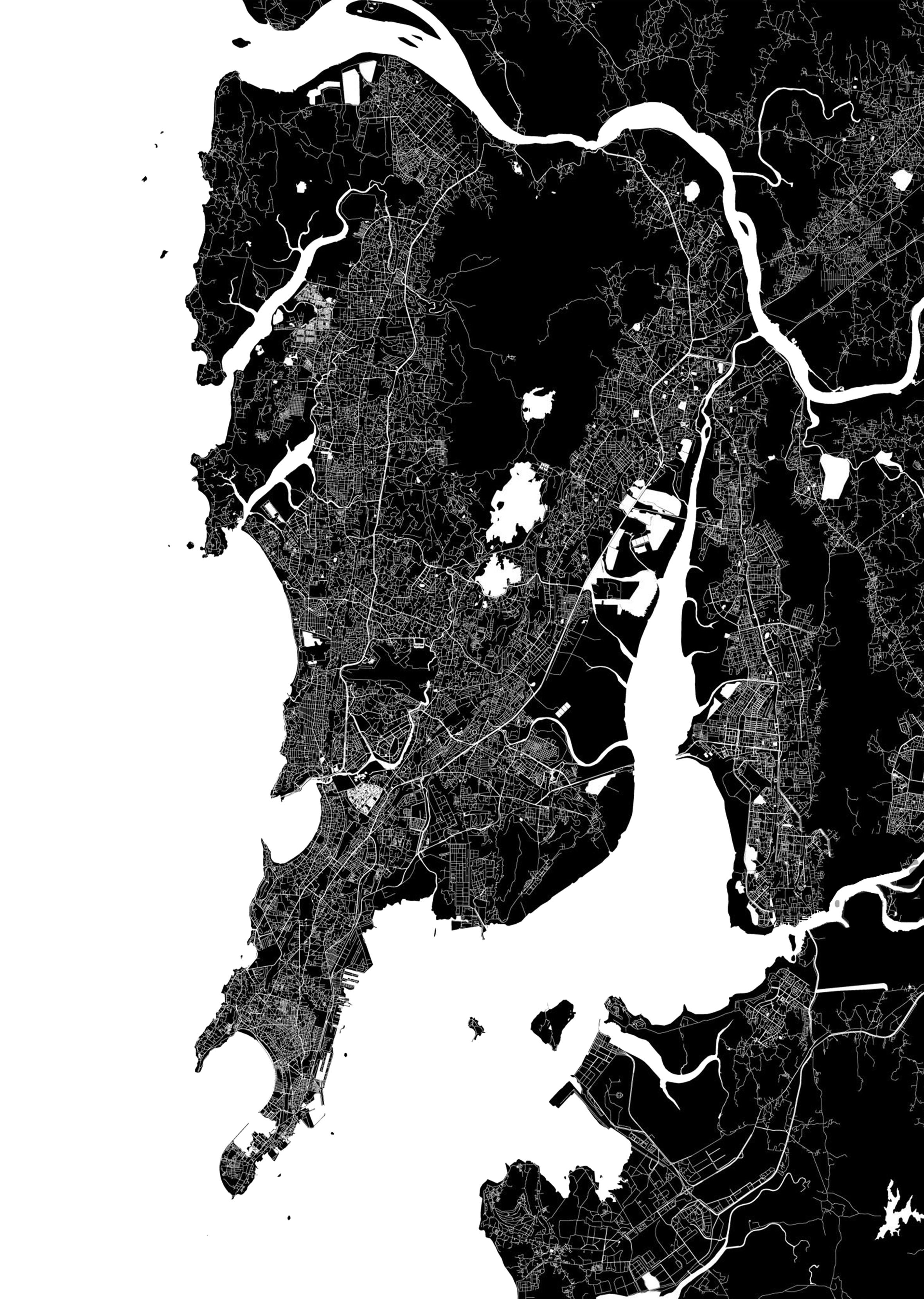
01 : Location within Mumbai City. Source : Shutterstock
part A1 & A2 - decipher and discover
01. Site Context
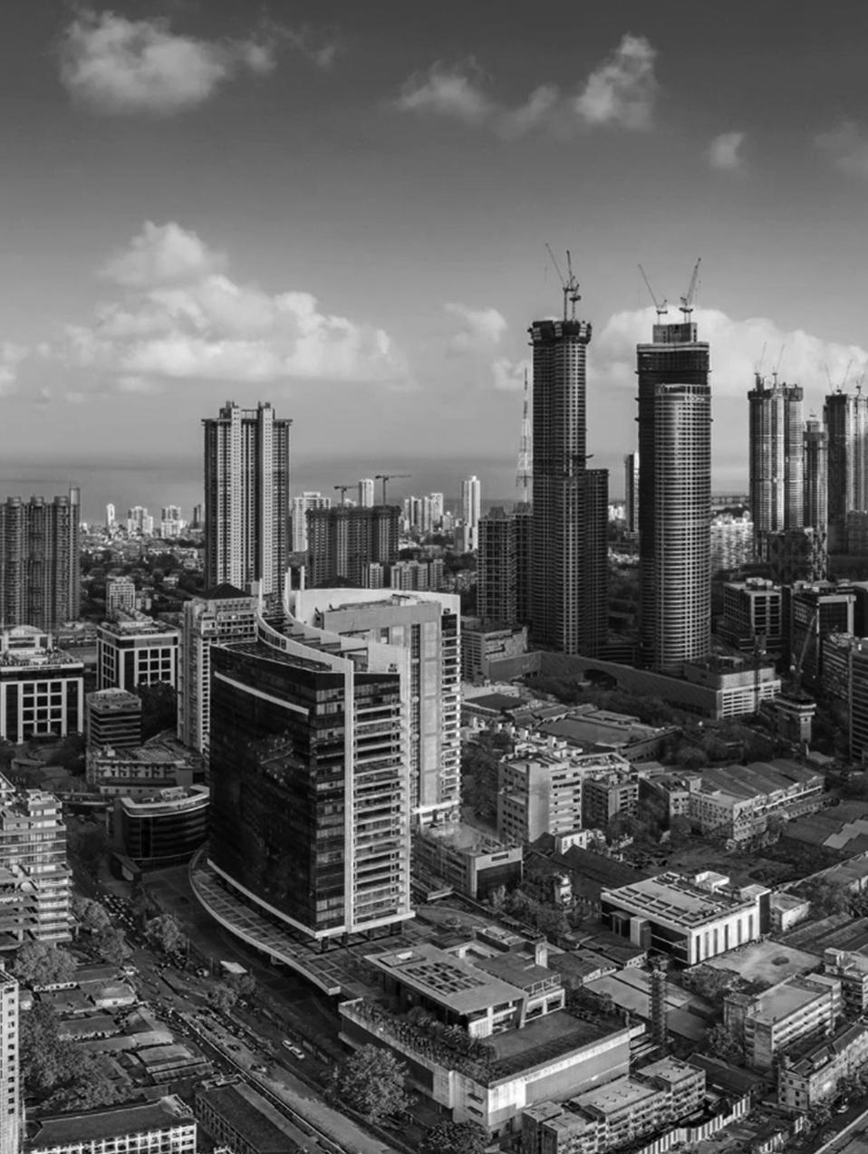
The morphology of the city of Mumbai as we know it today can be attributed to the unprecedented economic transformation of the island city over the centuries. No suburb is as emblematic to the growth and transformation of the city as is Lower Parel and hence its choice for this investigation is also vested in its evolution from a prominent industrial hub to a post-industrial neighborhood that gives its cityscape a metamorphosed appearance.
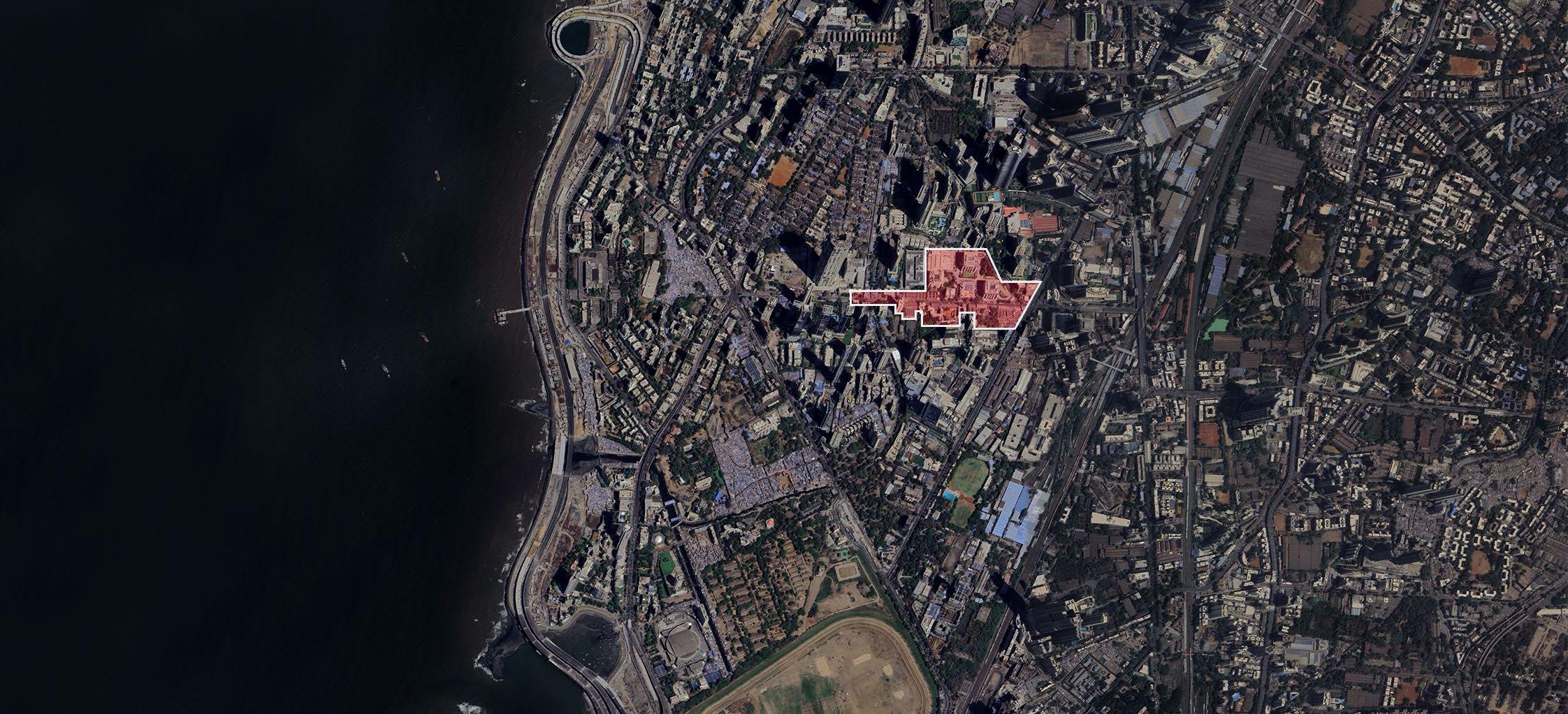
The selected site is located along Senapati Bapat Road in Lower Parel which lies in the G/S ward of the Mumbai City district. Worli on the west and south, Parel on the east, and Prabhadevi on the north form the boundaries of Lower Parel. The region used to be a prominent textile manufacturing area of Mumbai. At present Lower Parel bears the identity of a business hub and a posh urban neighborhood. for business. The cityscape earlier dominated by mills and chawls started giving way to the growth of malls, high-rise residential towers, corporate offices, boutiques, and discotheques.
According to the BBC Report – Lower Parel, Mumbai: One Square Mile of India'(2011), “Mumbai has always been short of space,and with so much prime land up for grabs, the developers moved in”. Thus, many of the defunct mill areas came to be redeveloped.
For example – the Phoenix Mills have been transformed into High Street Phoenix Mall; the Kamala Mills have been redeveloped into the Kamala Mills; and the New Islam Mills have been transformed into the One Avighna Park, a highrise residential project. Thus,there has been a phenomenal rise in property prices in Lower Parel.
02. Brief History and Former Planning Regulations
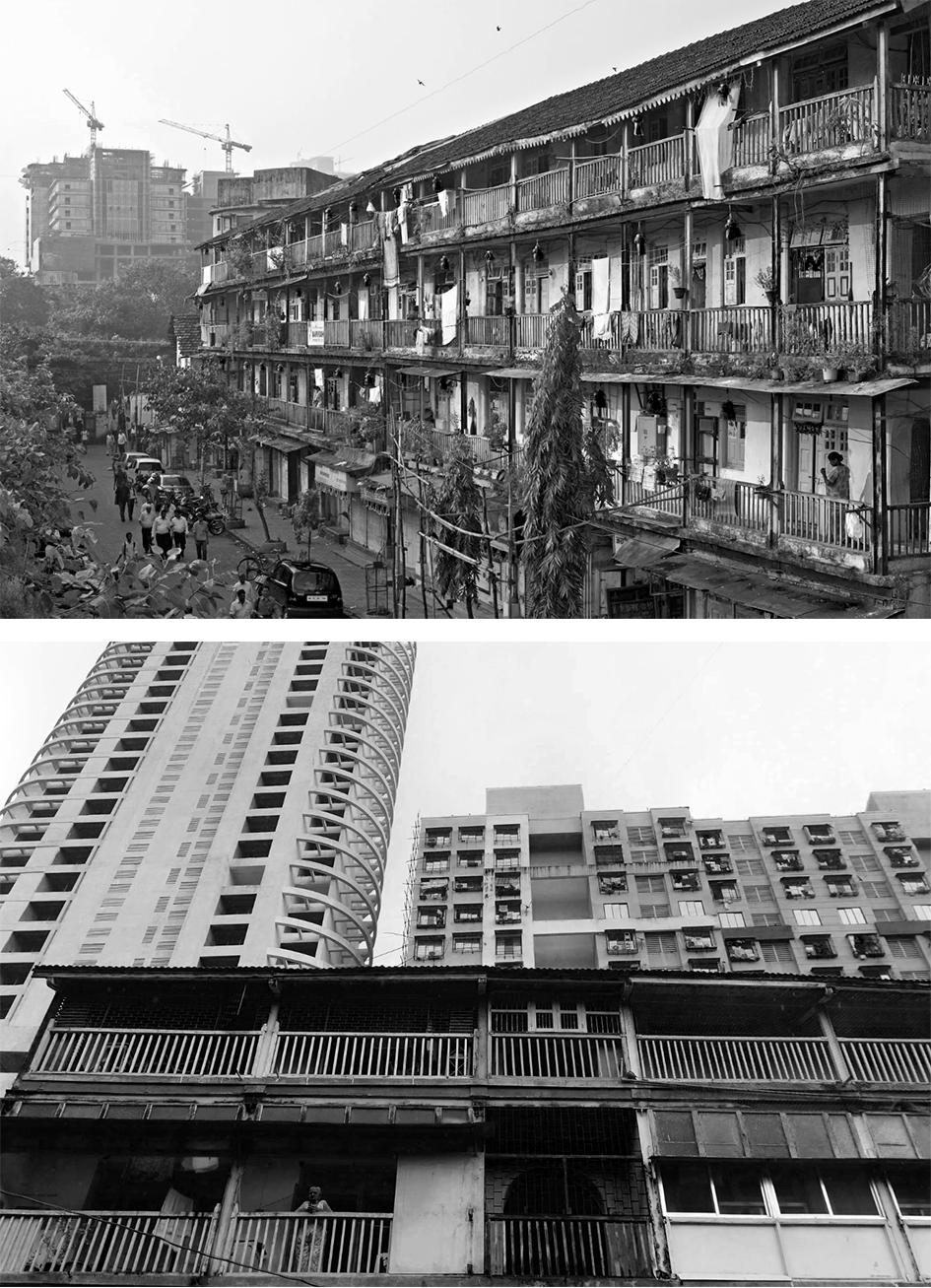
The British government introduced the City of Bombay Improvement Act, establishing the Bombay City Improvement Trust (BIT) to address the fact that an estimated 30 to 40 per cent of the city’s population was concentrated in a meagre 3 to 4 per cent of its land. Constituted in 1898, the BIT aimed to widen roads, restructure old buildings and create more open spaces in the city. Nevertheless, the housing crisis persisted, compelling the British government to establish the Bombay Development Department (BDD) in 1920, which undertook the building of publicly funded chawls.
This institutionalising of the chawl typology standardised its architecture, plugging it into the city’s larger system of services (water supply, drainage, sewerage and electricity). At present, there are a total of 207 BDD chawl complexes in the Island City.
03. Existing Scenario
The proposed razing of the chawls is designed to free up real estate in South Mumbai for the city to grow. The chawls are low-rise buildings in a prime area, and the government wants to replace them with buildings that will use the maximum allowable floor space index (FSI), with developers applying pressure to make these areas of the city available to investors. But the plan is likely to do little in addressing the city’s rising density and the need to provide accommodation for all its citizens.
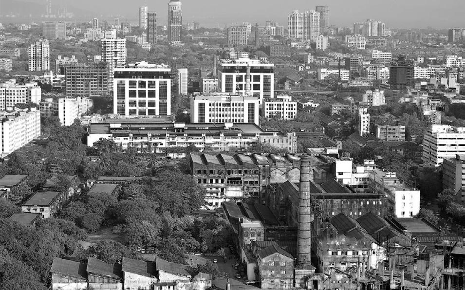
Though the redevelopment of mill lands is gradually leading to the metamorphosis of Lower Parel's cityscape, the infrastructural drawbacks existent in the region imposes upon it a conflicting character. Outside the compounds of the redeveloped properties and the gated communities formed, there lies an array of narrow roads and lanes along with other decaying old structures.
Vehicles getting stuck in jams while maneuvering across the narrow passages and people often bumping almost into each other are not a rare sight in Lower Parel. Besides, in the wake of the rising number of vehicles in the region, lack of parking space contributes further to the congestion. This stained infrastructure is a major jolt in the region's carrying capacity that poses a threat to its sustainability.
04. Existing Regulations
Mumbai's existing development control and promote regulations for FAR and height restrictions are based on the width of abutting roads while margins depend on land use, and parking norms adhere to the ECS method.
For Residential/Commercial
Road Widths (m)
Margins
3.6m on all sides
4.5m on all sides
6.0m on all sides
6.0m on all sides
Institutional (Educational) (Medical)
05. Existing Urban Form
The Maharashtra Housing and Area Development Authority (MAHADA) has already begun to raze the first of 195 BDD chawls that have been earmarked for demolition in South Mumbai. It is one of the biggest redevelopment projects in Asia, estimated to be worth more than Rs. 17,000 crore (roughly £16.65bn), and the government has promised that residents of the demolished chawls will be rehoused in the same area during construction.
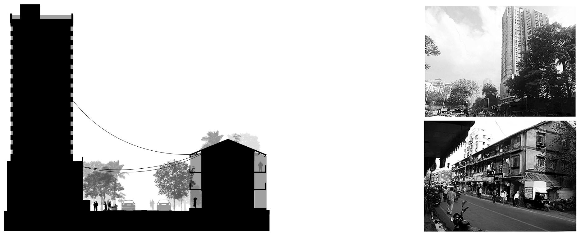
Fig 06 : Street section through the site highlighting its characteristic urban form.
Source : Authors, Google Street view
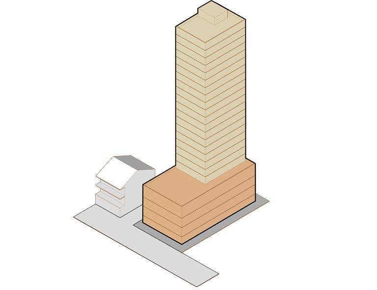
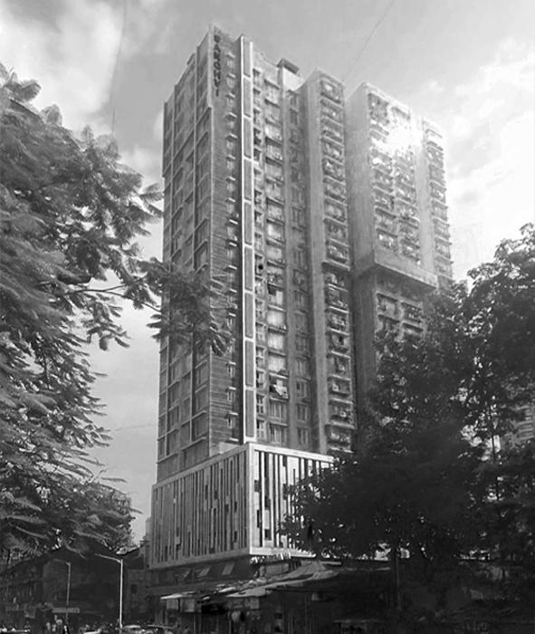
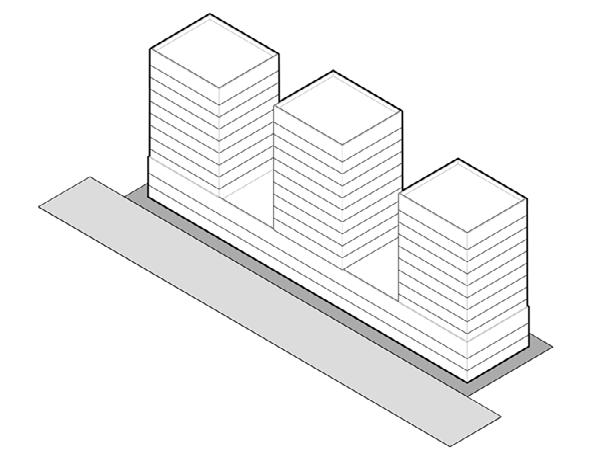
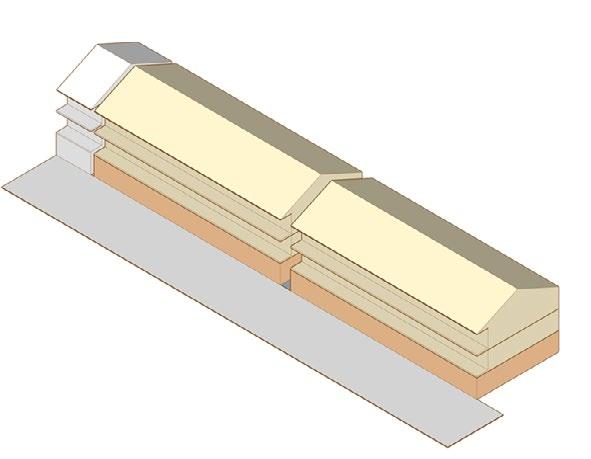
Within the selected site, we have identified two buildings as case studies to examine the impact of current regulations on the built form. The rationale for selecting these particular buildings lies in their contrasting characteristics. The first building is a newly developed mixed-use midrise structure, exemplifying contemporary design and regulatory frameworks. In contrast, the second building is an old BDD chawl that reflects the urban form shaped by the older regulations of the Bombay Improvement Trust. This juxtaposition allows for a comprehensive analysis of how differing regulatory environments have influenced the built form along a single street, highlighting the evolution of urban development over time.
Source : Google Street View
Margins
Height
on all sides
1 parking space for every 60sq.m
Note
Remarks
on all sides, 1.50m front
No data
Building follows DCPR 2034
With an abutting road width of 15 m, the plot qualifies for additional FAR through premium and TDR. The existing built form, achieved through TDR, significantly influences the street character.
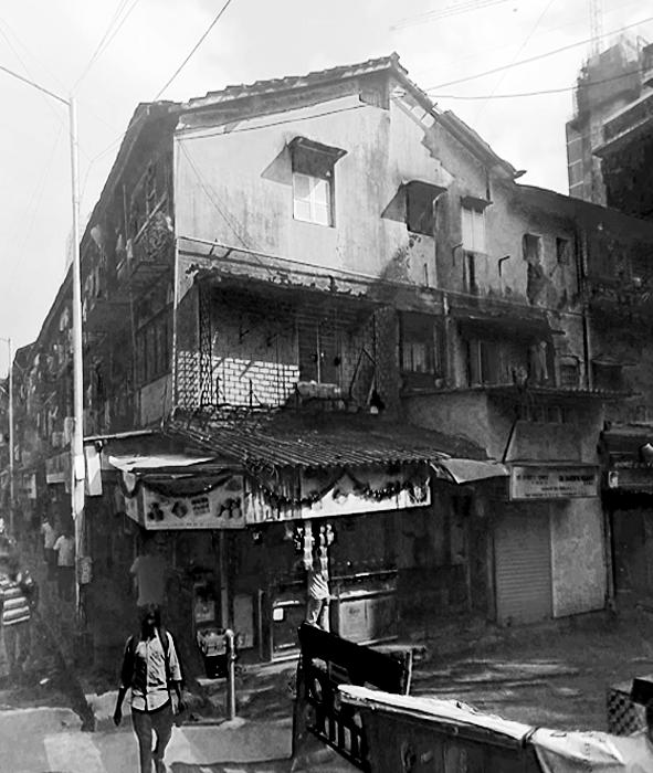
Source : Google Street View
Margins
Height
Note
Remarks Parking
on all sides No margins provided
1 parking space for every 60sq.m No parking provided Consumed
Building follows Bombay Improvement Trust regulations.
Built in 1918 by BDD, these chawls are now eligible for redevelopment under the 2014-2034 DCPR. The G+3 chawls are built to line without adhering to safety or margin regulations.
part B1 - envisioning builtform
01. Vision
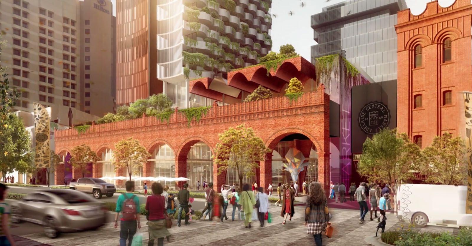
In a modern interpretation of one of the city’s oldest mill compounds, turned today into country's costliest commercial real estate, this redevelopment will create a vibrant mixed-use destination that seamlessly integrates the historic mill compounds along Senapati Bapat Road with arcades of Mumbai's oldest central business district.
The vision is to develop pedestrian links between the compounds and the busy streetfronts to enhance the walkability of the whole precinct while retaining the character.
02. Character Concept
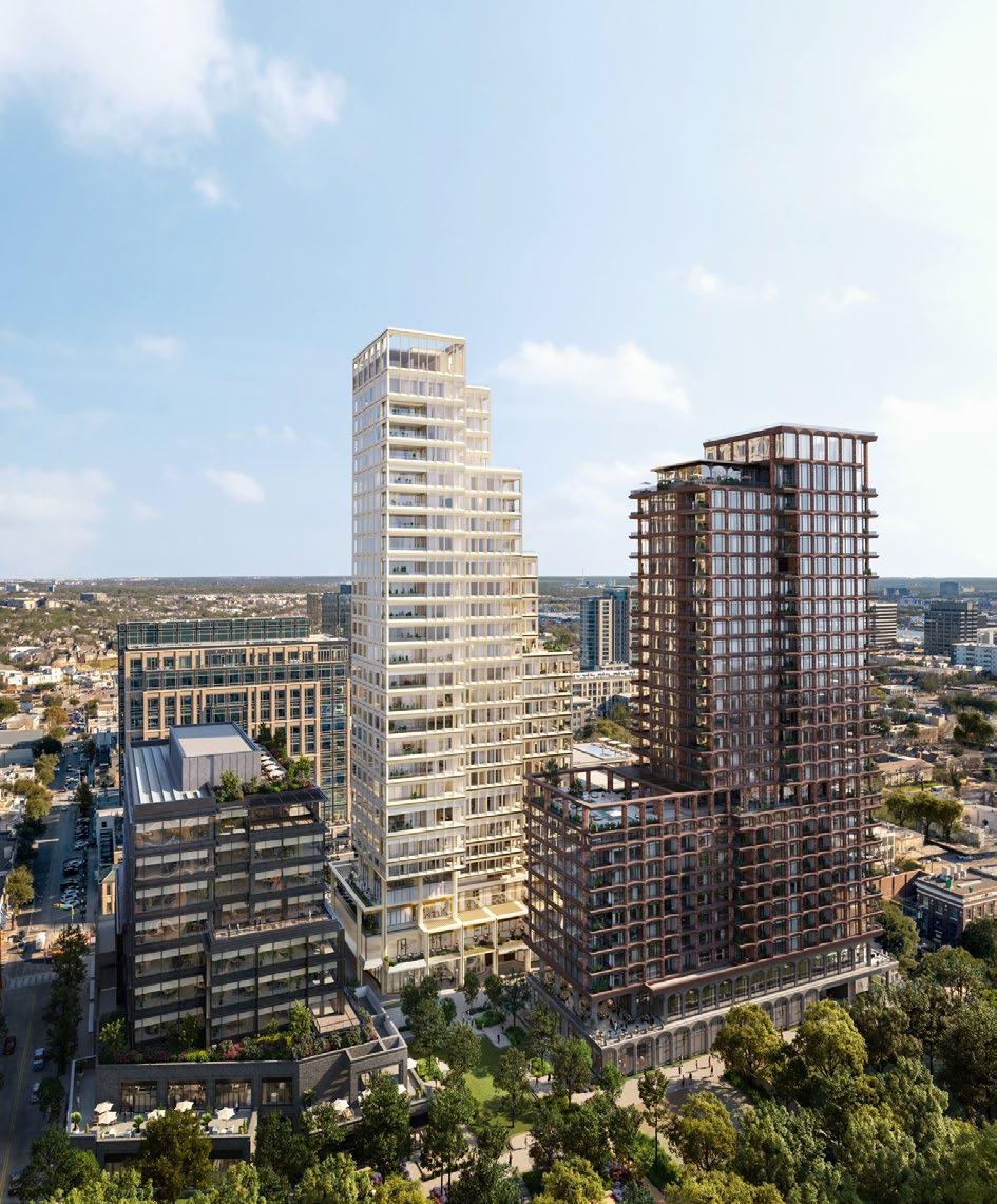
One of the primary goals is to create the feeling of a city built over time, with distinct language and identity for each building. The architecture is encouraged to be articulated to create a human scale at ground level, variegated tower massing, and to create outdoor spaces woven throughout the vertical development.
The arcades reinstates the emblematic arches of the original commercial estates of Ballard Estate in the heart of the city. The arches, while responding to the climate of the isalnds city shall also extends the public realm into the private.
03. Base Map
This base map outlines the study area boundary and demarcated plots, highlighting the site's context. The map reveals significant variations in plot sizes and shapes, particularly along narrow streets, indicating more irregular development patterns.
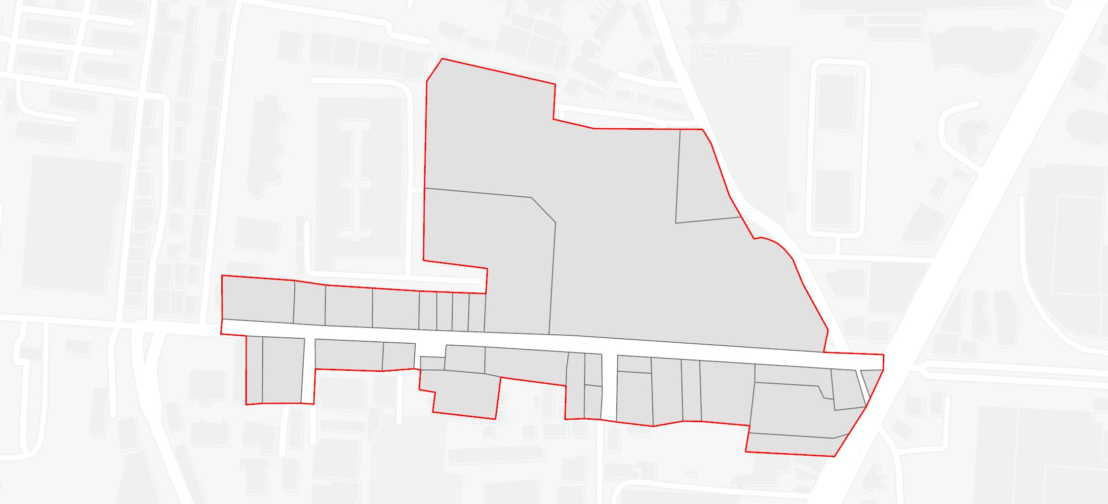
Scheme boundary - Plot
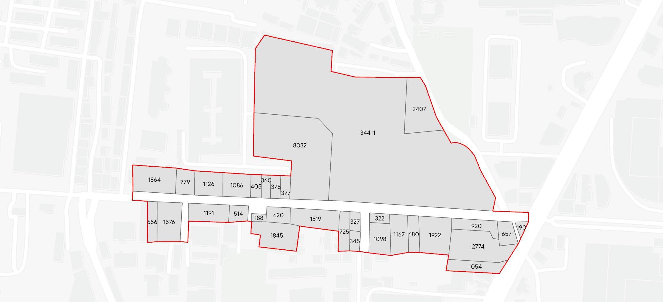
04. Plot Areas
This map highlights the area of each plot within the study boundary. Plot sizes vary significantly, ranging from 188 sq m to 34,411 sq m, showcasing the diversity in land parcel dimensions throughout the site.
Scheme boundary - Plot
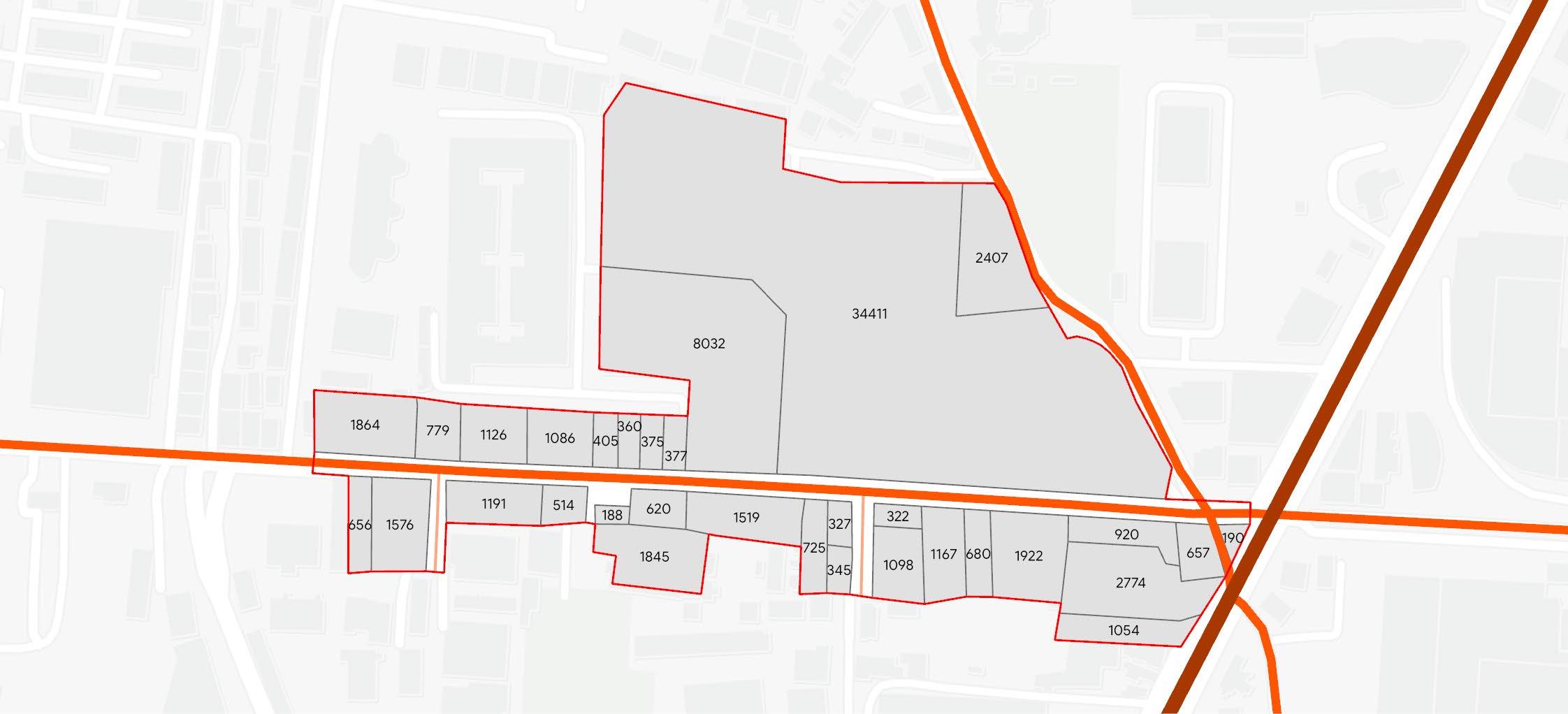
05. Road Connectivity
This map illustrates the road network within the study area and its immediate context. A 15 m collector street traverses the area, linking to the 27 m sub-arterial street, Senapati Bapat Marg, enhancing accessibility and connectivity.
06. Proposed Zoning
- Scheme boundary
- Plot - Sub-arterial road
- Collector road
- Local road
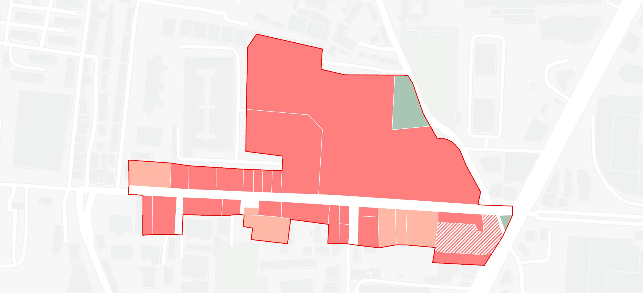
This map depicts the land use zoning within the study area, classified based on street width. High-intensity zones are designated for plots adjacent to streets with a right-of-way of 18-30 m, while medium-intensity zones apply to those with a right-of-way of 12-18 m. Reserved plots, as per Mumbai's master development plan, remain unchanged.
- Scheme boundary
- Parks and recreation Zone

- High-Intensity Mixed Use Zone
- Medium-Intensity Mixed Use Zone
- Reservations
07. Plot Ownership
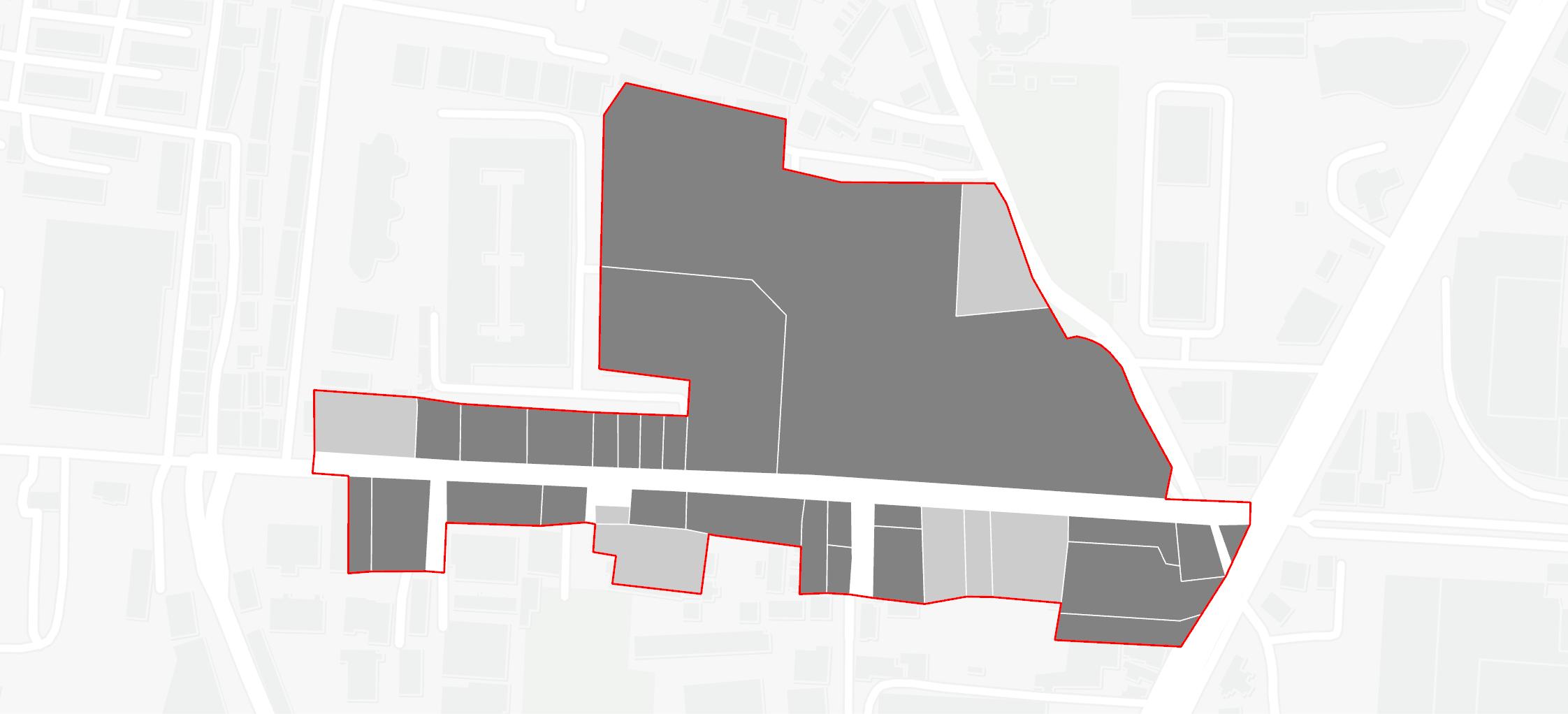
This map displays the ownership status of the plots within the study area. It distinguishes between privately owned plots and those owned by public entities, providing a clear overview of land ownership distribution across the site.
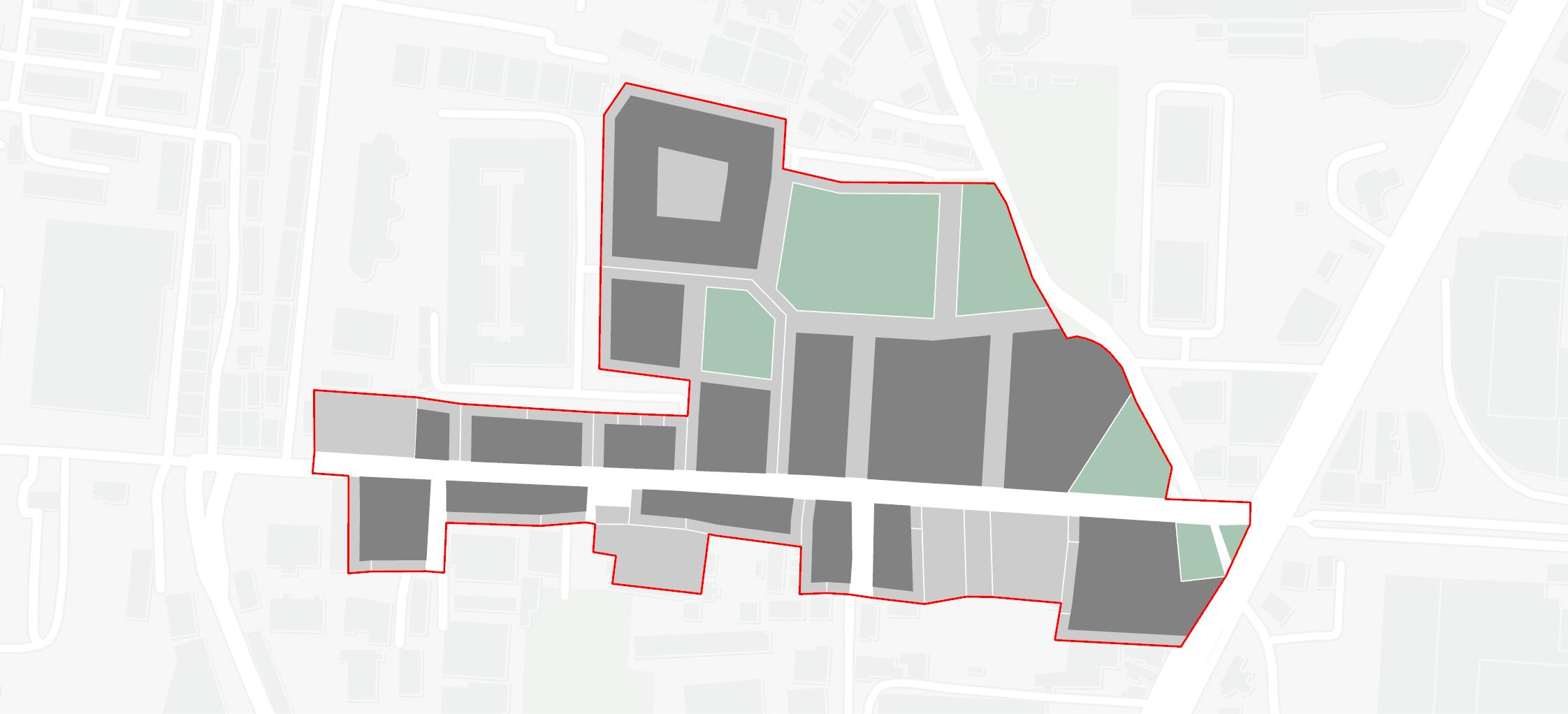
08. Built vs. Open
This map illustrates the proposed built form resulting from the newly established regulations. It highlights building footprints in relation to site margins, common open spaces, built-to-line requirements, and pedestrian pathway regulations, ensuring contextual compatibility within the area.
09. Envisioning
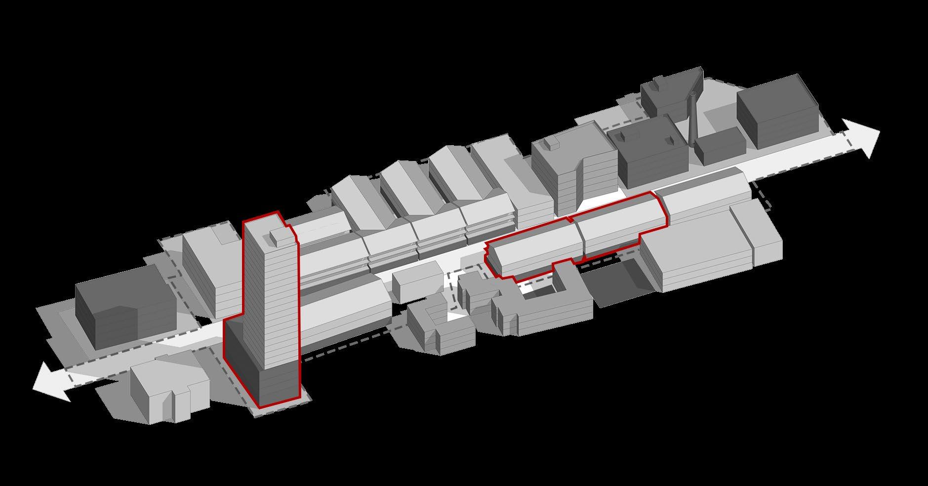
The 3D visualization presents a detailed representation of the anticipated built form resulting from the newly established regulations. It demonstrates how the proposed building footprints, site margins, and common open spaces will integrate harmoniously within the existing urban context.
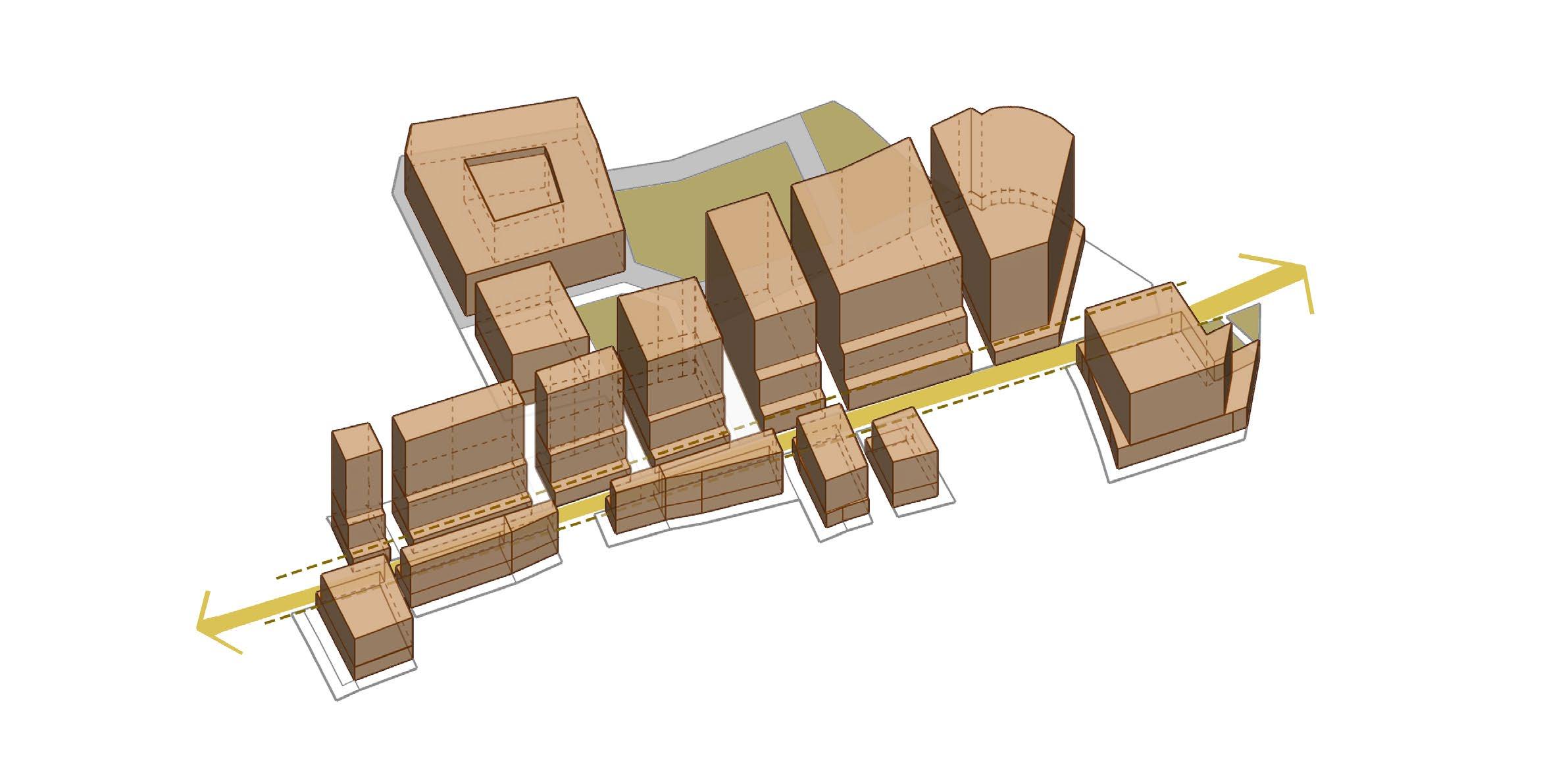
Fig 07 : Envisioned potential
With a right-of-way (ROW) of 15 meters, where vehicular lanes occupy the carriageway, the design incorporates arcades that support street vending while prioritizing pedestrian access. These built-toline regulations enhance the relationship between the street and built environment, allowing users to engage with the spaces flexibly. Step backs have been recommended in accordance with fire and safety regulations, particularly for the planned high-rise buildings, to enhance light and ventilation.
Additionally, the visualization highlights designated common open spaces that provide essential breathing room within the dense urban fabric, promoting community interaction and enhancing overall livability. Pedestrian pathways emphasize connectivity and accessibility, creating an inviting atmosphere for residents and visitors alike
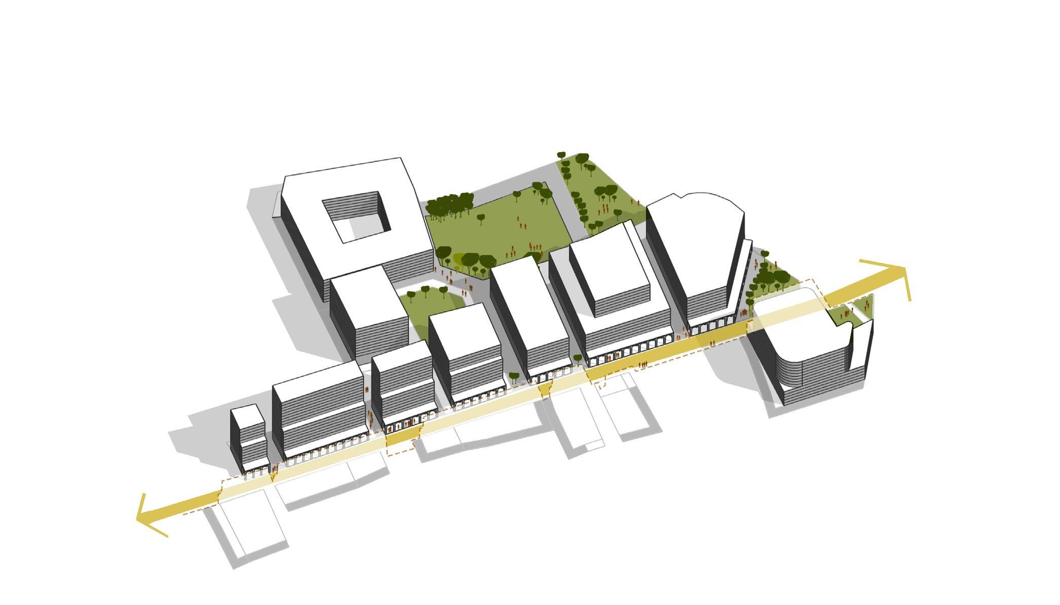
Fig 08 : Envisioned buit form
In conclusion, this 3D visualization serves as a valuable resource for stakeholders to comprehend the potential impacts of the new regulations, facilitating informed discussions on urban design and planning decisions aimed at fostering a balanced and sustainable urban environment.
part B2 - development control regulations
01. List of definations
Base Height refers to the maximum height allowable in a particular development intensity zone without premium charge.
Basement refers to the lower storey of a building having at least half of the clear floor height of the basement or cellar below average ground level.
Build to Line refers to a line with which the exterior wall of a building in a development is required to coincide. Some percent of the roadside façade area of the ground or more floors in buildings with more than one floor, may extend to the road-side property line so that the building visually reinforces the building façade line of the street.
Building Height refers to the vertical distance measured from the sidewalk along the plot and up to the top of the finished level of the topmost floor slab or in case of flat roofs up to the midpoint of the height of the sloping roof excluding the genuine stair cabin, water tank, and lift room. The height of the sloping roof shall be taken as an average height of the relevant floor.
Building Line refers to the control line up to which the plinth of a building adjoining an existing, proposed or extended street may lawfully extend and includes the lines described in any TP Schemes and/or Development Plan.
Front (Roadside) Margin refers to the space provided from the road-side edge of the plot. In case a plot as multiple roadside edges, all of such edges shall be considered as Front (roadside) margin.
Frontage refers to the length of the front main edge of a plots on the road-side. For plots abutting two or more roads, the side along the wider road shall be considered as the frontage.
Permissible Height refers to the basic height permitted by the Competent Authority as a matter of right.
Plinth refers to the solid or hollow volume below the floor which is immediately above the ground level.
Plot refers to a single or an un-subdivided unit of land owned by a single owner or jointly owned by a group of owners, which can be developed as a single use or mixed-use development. A plot can be merged with another plot or could be further subdivided into multiple smaller plots through a layout approval by the appropriate authority.
Podium refers to one or more floors of a building extending beyond building line used for parking, providing other services and incidental purposes as prescribed under these Regulations.
Premium Height refers to the height available by payment.
Rear Margin refers to the space provided from the rear edge of the Building-unit.
Side Margin refers to the space provided from the sides of the Building-unit.
Transferable Development Rights (TDR) refers to an incentivization mechanism by which compensation in the form of Floor Space Index (FSI) or Development Rights is provided which shall entitle the owner for construction of built-up area subject to provisions in this regulation.
02. Introduction
The envisaged plan for Senapati Bapat Marg, Lower Parel, aims to bring a distinct, familiar character into the area without losing the efficiencies offered by current zoning. The zoning also accommodates enhanced infrastructure provisions, with designated areas for public amenities, green spaces, and social infrastructure to support the growing population.
03. Proposed Zoning
The proposal zoning emphasizes the creation of public open spaces, pedestrian-friendly environments, and efficient land use. While maintaining existing efficiencies, theres also an intent to direct development and market pressures. As part of this strategy, the delineated boundary has been divided into two distinct zones, each playing a key role in fulfilling this vision.
Strategy for zoning :
1. High-Intensity Mixed Use Zone (HMU)
2. Medium-Intensity Mixed Use Zone (MMU)
3. Parks and Recreational Zone (PR)
High-intensity zones require robust infrastructure to support the demands of a dense population and high activity levels. This might include enhanced public transportation, larger utility networks, and specialized waste management. Medium-intensity zones require scaled-back infrastructure, sufficient to serve moderate density and activity levels, which can reduce strain on municipal services and provide more affordable options for businesses and residents.
Distinguishing between zones ensures that infrastructure investment and services are appropriately matched to the needs of each area, enhancing efficiency. This zoning differentiation allows for strategic economic growth, catering to different types of businesses and employment opportunities. By separating these zones, the intention is to minimize conflicts between incompatible uses and create environments suited to their intensity levels.
High-Intensity Mixed Use Zone (HMU) -
Medium-Intensity Mixed Use Zone (MMU) -
The high-intensity mixed-use zone is planned along wider roads, which can handle higher traffic volumes and pedestrian activity. The wider roadways provide the necessary infrastructure for a more active and dynamic urban environment, ensuring efficient traffic management and optimizing land use in key areas of the city with strong accessibility.
The medium-intensity mixed-use zone is designated for areas with narrower roads, where managing traffic flow is crucial. This zone is focused on maintaining a well-balanced environment with lower volumes of movement, ensuring that the road network can effectively support the intensity of use without placing undue strain on the infrastructure.
Parks and Recreational Zone (PR) -
The parks and recreational zone is intended to provide much-needed green spaces within the dense urban areas. These spaces offer the public areas for relaxation and recreation, ensuring accessible open spaces within the city's-built form.
04. Zones and Permissible Uses
Permissible building uses refer to the specific types of activities or functions that are allowed within a particular zoning district as defined by a municipality’s zoning code. The regulations within each zone specify whether these uses can coexist within the same building or if they shall be separated by building or floor.
Below is a detailed description of permissible activities within each classified building use. * Reservations as per the Development Plan prepared by the Municipal Corporation of Greater Mumbai. Table 01 - Zonewise Classification of Permissible Building use.
A more nuanced approach to defining permissible uses within mixed-use zones could allow for greater adaptability and innovation. This flexibility could facilitate a more context-sensitive mix of uses that evolves with the community's needs, supporting an approach that balances economic growth with social, environmental, and cultural priorities.
Dwelling DW Apartment, Hostel, Dharamshala, Pre‐school and Affordable Housing
Mercantile - 01 M -1 Shop, Business, Restaurant, Shopping Centre, Light Home Workshop, Service Establishment, Clinic, Fitness Centre
Mercantile - 03
-3 Wholesale Market, Indoor Hospital, Wholesale Market and their ancillary uses, Activity Related to I.T.
Surgical Hospital, Nursing Home
07 Religious REG Temples, Church, Mosque, Gurudwara, Synagogue, Upashraya, Sant Niwas or any Religious Structure. 08 Hospitality HO Bed and Breakfast, Guest House, Lodging and Boarding, Hotel, Motel, Serviced Apartment
Sports and Leisure SPL Swimming Pool, Art Gallery, Closed Exhibition Hall, Motion Picture Hall
05. Zones and Floor space
The objective is to regulate floor space and zoning in a manner that ensures efficient land use, equitable development, and sustainable urban growth, while maintaining the character of different zones and safeguarding public interest.
Table 03 - Building Zone wise Permissible Floor Space.
*Medium-Intensity Mixed Use Zone – Only valid for specific plot sizes as mentioned in the detailed development codes for the given zone.
**In the event of plot amalgamation, any premium height that would typically require purchase will be granted free of cost, provided the amalgamated plot complies with the minimum width of the plot needed along the roadside frontage.
05A. High Intensity Mixed Used Zone
Introduction
The high-intensity mixed-use zone applies to plots abutting roads with widths between 18 and 36 meters. All developments on such plots shall adhere to the regulations set forth for this zone, ensuring that the intensity of use is in line with the capacity of the road infrastructure. Typically located along major transportation corridors and wider roads, HMU zones aim to optimize land use, enhance accessibility, and promote vibrant, walkable neighborhoods.
05A.1 - Plot Sizes
• In the high-intensity mixed-use zone, the minimum plot width on the road frontage shall be at least 15 meters, measured after accounting for the required side setbacks. This ensures that the plot remains buildable in accordance with the regulations.
• For plots with frontage widths less than 15 meters, amalgamation with adjacent plots is required to maintain buildability. Incentives for plot amalgamation, as detailed in the chapter titled Zone and Floor Space, will apply.
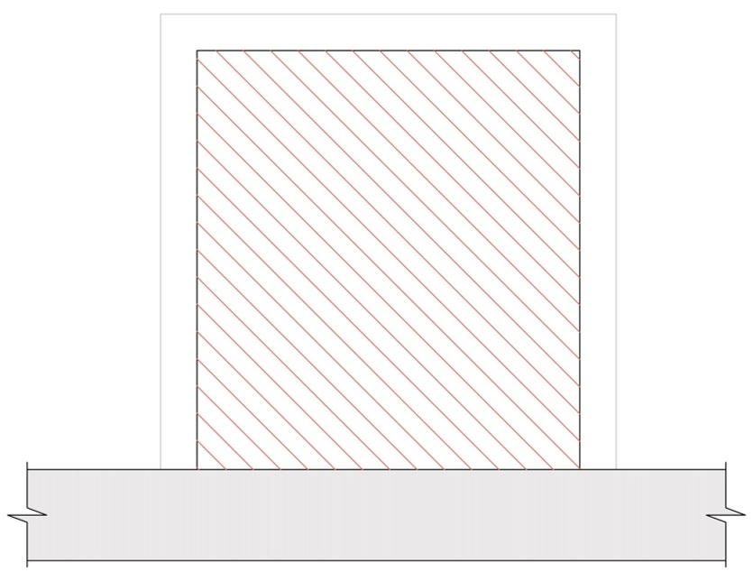
05A.2 - Set backs
The premise is to establish setback regulations that ensure adequate space for light, air, safety, privacy, and welfare, while promoting urban development.
Table 04 - Setbacks for Buildings in HMU.
05A.3 - Built to line
• All buildings on plots adjacent to the road shall adhere to the build-to-line.
05A.3.2
• The minimum building height along the build-to-line, incorporating arcades, shall be 12 meters measured from the sidewalk level, and the building shall feature active frontage.
05A.3.3
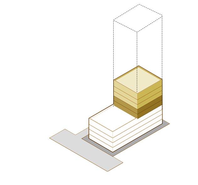
• Beyond the height of 12 meters, all buildings shall be recessed by 10 meters. Additionally, after reaching a height of 27 meters (i.e., a total of 39 meters from sidewalk level), buildings shall be recessed again by 6 meters.
05A.3.4
• A maximum of 60% of the building frontage shall be constructed to the building line. The remaining 40% of the frontage shall be maintained as open space to help enhance the streetscape and to also further promote pedestrian activity.
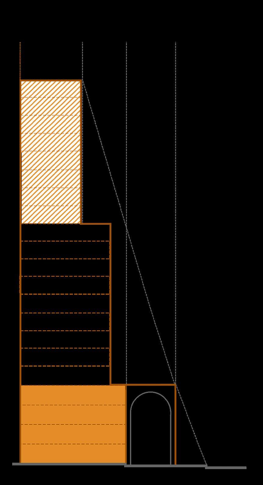
Fig 10 : Typical setback for buidings in HMU
05A.4
05A.4.1
05A.4.2
05A.4.3
05A.4.4
05A.4.5
05A.4.6
05A.4.7
- Arcades
• An arcade shall be built as part of the building along the built-to-line.
• The arcade shall have a fixed clear height of 8 meters from the sidewalk level.
• The arcade shall maintain a continuous width of 6 meters from the built-to-line.
• The minimum clear width of the arcade shall be 5.4 meters.
• The maximum clear distance between columns forming the sides of the arcade shall range between 5.5 meters and 6.2 meters. The column width shall not exceed 1 meter.
• The arcade shall remain a clear, continuous volume, free from steps, walls, or any other obstructions.
• The arcade shall be fully accessible along the entire stretch of the adjacent sidewalk, without any sort of physical barriers.
05A.5 - Green Open Spaces
The principle is to create open public spaces that ensure accessibility, sustainability, and functionality of these spaces for diverse users and accomodate all scales of activities.
Table 05 - Plot Wize Wise Minimum Mandated Public Open Space
05A.5.1
• The calculation of common open space for a given plot shall exclude any areas designated as margins. Only the spaces remaining after the deduction of margin areas will be considered in the total calculation of common open space.
• Such greens shall be kept un-gated, have direct access and shall be handed over to the concerned local body for maintenance. No parking or basements shall be permitted under or beneath such greens.
05A.6 - Basements
• The basement may be constructed from the front plot line. Open spaces from all plot boundaries, including side and rear setbacks, shall not be less than 6.0 m. Basements may be at one level or more.
• The height of the basement from the floor to the underside of the roof slab or ceiling shall not be less than 2.4 m and shall not exceed 3.9 m below the soffit of the slab. Additional height may be permitted for mechanical parking as required.
• Openings or ventilation shafts connected to the outside shall meet a minimum size requirement, a minimum 5% of the floor area, to allow for proper airflow.
05A.7 - Parking
• Parking on the ground floor is not permitted. Additionally, any floor space utilized for parking shall not be exempt from the total available floor space calculation.
Table 06 - Parking Regulations
05A.8
- Road Network
• The road networks shall be planned with a pedestrian network of approximately 100 m c/c.
• All vehicular entries shall be from the side streets
05B. Medium Intensity Mixed Used Zone
Introduction
The medium-intensity mixed-use zone applies to plots abutting roads with widths varying between 12 meters and 15 meters. All developments on such plots are required to adhere to the regulations set forth for this zone, ensuring that the intensity of use is in line with the capacity of the road infrastructure. The regulations aim to maintain efficient traffic flow and appropriate land use in these areas, keeping the scale and activity of development proportionate to the road width.
05B.1
05B.1.1
- Plot Sizes
• In the medium-intensity mixed-use zone, the minimum plot width on the road frontage shall be at least 15 meters, measured after accounting for the required side setbacks. This ensures that the plot remains buildable in accordance with the regulations.
• For plots with frontage widths less than 15 meters, amalgamation with adjacent plots is required to maintain buildability. Incentives for plot amalgamation, as detailed in the chapter titled Zone and Floor Space, will apply.
05B.2
- Set backs
The premise is to establish setback regulations that ensure adequate space for light, air, safety, privacy, and welfare, while promoting urban development.
Table 07 - Setbacks for Buildings in HMU.

05B.3 - Arcades
permissible building footprint ROW built to line
Fig 11 : Footprints, setbacks and built to line
• An arcade shall be built as part of the building along the built-to-line.
• The arcade shall have a fixed clear height of 8 meters from the sidewalk level.
• The arcade shall maintain a continuous width of 6 meters from the built-to-line.
• The minimum clear width of the arcade shall be 5.4 meters.
• The maximum clear distance between columns forming the sides of the arcade shall range between 5.5 meters and 6.2 meters. The column width shall not exceed 1 meter.
• The arcade shall remain a clear, continuous volume, free from steps, walls, or any other obstructions.
• The arcade shall be fully accessible along the entire stretch of the adjacent sidewalk, without any sort of physical barriers.
05B.4 - Green Open Spaces
The principle is to create open public spaces that ensure accessibility, sustainability, and functionality of these spaces for diverse users and accomodate all scales of activities.
Table 08 - Plot Wize Wise Minimum Mandated Public Open Space
05B.4.1
• The calculation of common open space for a given plot shall exclude any areas designated as margins. Only the spaces remaining after the deduction of margin areas will be considered in the total calculation of common open space. Such greens shall be kept un-gated, have direct access and shall be handed over to the concerned local body for maintenance. No parking or basements shall be permitted under or beneath such greens.
05B.5
- Built to line
05B.5.1
05B.5.2
• All buildings on plots adjacent to the road shall adhere to the build-to-line.
• The minimum building height along the build-to-line, incorporating arcades, shall be 12 meters measured from the sidewalk level, and the building shall feature active frontage.
05B.5.3
• Beyond the height of 12 meters, all buildings shall be recessed by 10 meters. Additionally, after reaching a height of 27 meters (i.e., a total of 39 meters from sidewalk level), buildings shall be recessed again by 6 meters.
05B.5.4
• A maximum of 60% of the building frontage shall be constructed to the building line. The remaining 40% of the frontage shall be maintained as open space to help enhance the streetscape and to also further promote pedestrian activity.
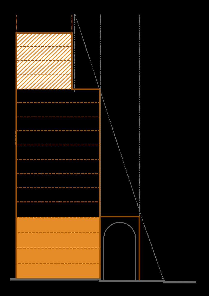
Fig 12 : Typical setback for buidings in MMU
05B.6
05B.6.1
- Basements
• The basement may be constructed from the front plot line. Open spaces from all plot boundaries, including side and rear setbacks, shall not be less than 6.0 m. Basements may be at one level or more.
05B.6.2
• Height: The height of the basement from the floor to the underside of the roof-slab or ceiling shall not be less than 2.4 m and shall not exceed 3.9 m below the soffit of the slab. Additional height may be permitted for mechanical parking as required.
05B.7 - Parking
05B.7.1
• Parking on the ground floor is not permitted. Additionally, any floor space utilized for parking shall not be exempt from the total available floor space calculation.
Table 09 - Parking Regulations
05B.8
- Road Network
• The
05.C Parks and Recreational Zone (PR)
05C.1 - Access
05C.1.1
• Every plot under recreational zone shall have an independent means of access.
05C.2 - Ground Coverage
05C.2.1
• A maximum of 10% of the ground area in public green spaces shall be covered. Additionally, temporary structures may be permitted within these areas.
part B3 - peer review
1. Suggestions and comments by peer group
01. Zones and Permissible Uses
Comment: Non permissible uses for each zone and college in the permissible uses list under education category to be added.
*It was believed that outlining permissible uses for each zone is a more effective regulatory strategy than concentrating on non-permissible uses, as the latter can lead to ambiguity. College has been included in the list of permissible uses under education category.
02. Regulations
Comment: Ground coverage and minimum plot size to be included as a part of proposed regulations. *It was believed that including ground coverage after accounting for margins would result in a reduced built-up area. However, by applying margins according to fire and safety norms and reserving the remainder of the plot for development, we can create larger developable land parcels.
Minimum frontage width for plots to be buildable has been mentioned in detailed development codes for specific zones.
03. Podium
Comment: Provide a list of permissible activities for step backs to enhance the character of the area.
*A regulation has been proposed stating, "No additions, whether temporary or permanent, structural or nonstructural, shall be allowed on any part of the podium that is open to the sky."
04. Built-to-line
Comment: While the built-to-line concept promotes uniformity, introducing flexibility in setbacks based on building typology or street context could be beneficial.
*The proposed margins for each zone have been determined based on the minimum fire safety requirements outlined in NBC Volume 4. Additionally, implementing a regulation for a built-to-line in the front margin aims to ensure uniformity in the built form, given that the frontage provides access from the abutting road.
05. Arcade
Comment: While the height and width are adequate, it would be beneficial to include guidelines for the usability of arcades.
*Design guidelines related to arcades have been outlined in the Local Area Plan Rulebook.
part B4 - group synthesis
1. Learnings and Outcomes
The Built Form and Regulation course provided profound insights into the intricate relationship between urban regulations and the physical development of cities. The studio's primary objective was to understand the current built form and critically analyze the underlying factors influencing it, questioning whether the built environment results from regulatory frameworks or other external factors. This analysis encouraged us to explore paradigms such as whether the built form complements the context and market, and if it is liberal enough to foster growth.
A significant takeaway was the importance of aligning regulatory frameworks with the perspectives and needs of key stakeholders, particularly developers and the market, who are central to urban transformation. We learned that regulations shall be crafted in clear and legible language, ensuring they are comprehensible to laypersons. Additionally, there shall not be any loopholes in the built form regulations that individuals can exploit, and the regulations shall be equitable, free from bias toward any group.
Engaging in peer reviews provided practical insights into the viewpoints of various stakeholders, enhancing the overall effectiveness of regulatory frameworks. In conclusion, this course has transformed our understanding from passive observation to active participation in the evolution of urban regulations. It has deepened our comprehension of urban planning and governance, equipping us with the knowledge and skills necessary to contribute to sustainable urban development. The course reinforces the dynamic nature of urban planning and the critical importance of collaboration among all stakeholders in shaping resilient and thriving urban environments.
annexures
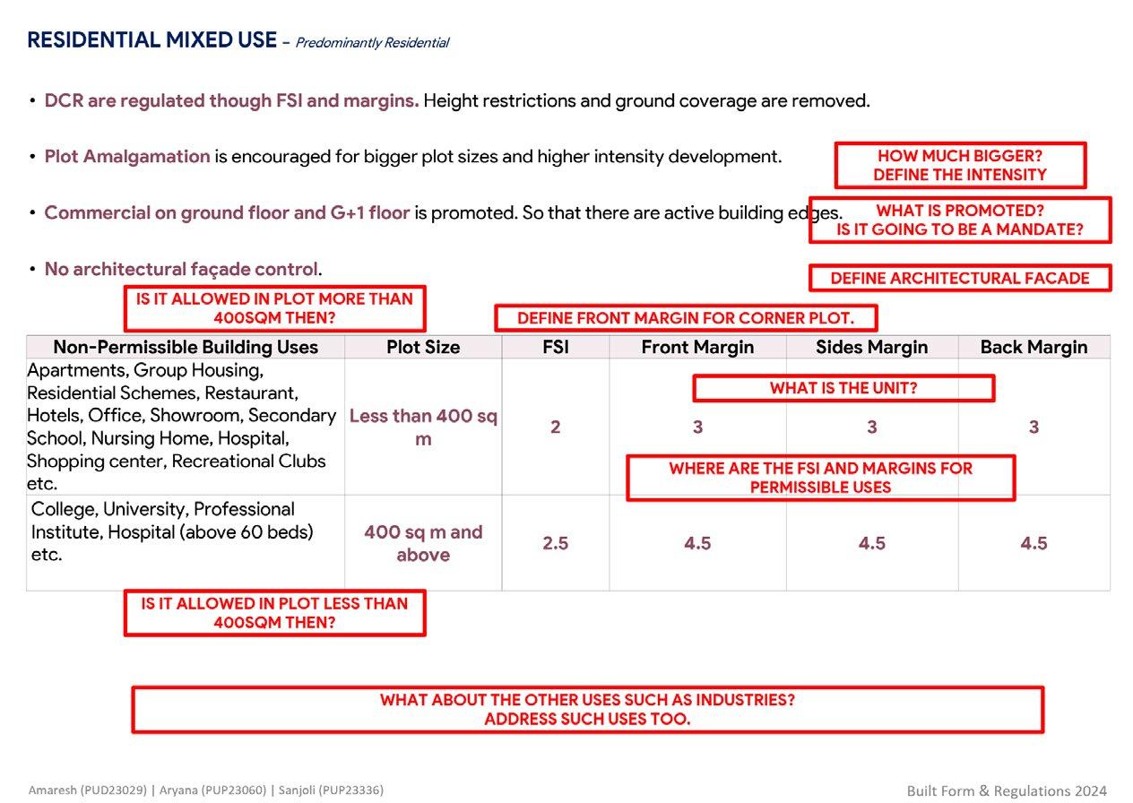
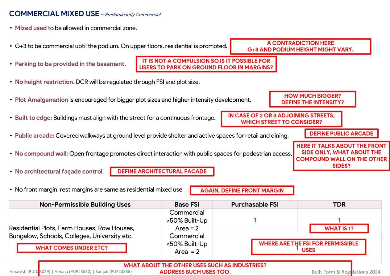
• Clarify the size: "How much bigger?"
• Specify the intensity: "Define the intensity"
• Clarify promotion vs. mandate: "What is promoted? Is it going to be a mandate?"
• Provide architectural clarity: "Define architectural façade"
• Specify front margin for corner plots: "Define front margin for corner plot"
• Clarify plot size conditions: "Is it allowed for plots larger than 400 sqm?"
• Include FSI and margin details for uses: "Where are the FSI and margins for permissible uses?"
• Address inconsistency: "A contradiction here – G+3 and podium height might vary."
• Clarify parking rules: "Is parking on the ground floor in margins allowed if it’s not compulsory?"
• Clarify street consideration: "In case of two or three adjoining streets, which street should be considered?"
• Define public space: "Define public arcade."
• Address boundary conditions: "The document talks about the front side only. What about the compound wall on the other sides?"
• Provide architectural clarity: "Define architectural façade."
• Clarify unspecified elements: "What comes under etc.?"
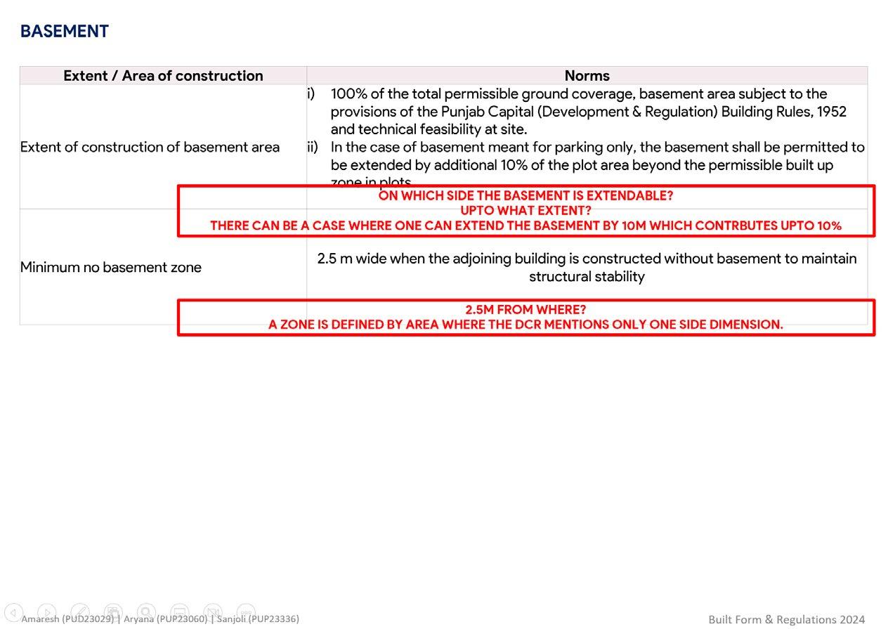
• Clarify basement extension: "On which side is the basement extendable?"
• Specify the extent of extension: "Up to what extent?"
• Address potential basement size issues: "Can the basement be extended by 10m contributing up to 10%?"
• Clarify measurement reference: "2.5m from where?"
• Define zone dimensions: "A zone is defined by an area, but the DCR only mentions one side dimension."
bibliography
Bhattacharjee, S. (2017, March). 'Cityscape Metamorphosed - Indications of spatial transofrmation in Lower Parel, Mumbai'
Sanap, S. (2022, November). 'Urban design study of Dadar & Prabhadevi, Mumbai, Academy of Architecture'
Basu, U. (2022, February) 'Makeshift Urbanism: Rekindling the underutilized spaces of Mumbai.'
Nallathiga, R. (2009, November) 'From Masterplan to Vision plan'- Chnaging roles of plan and plan making in city development (In reference to Mumbai)
Development Control and Promotion Regulation 2034
Development Plan - 2034 of Greater Mumbai
Faculty of Planning CEPT University
