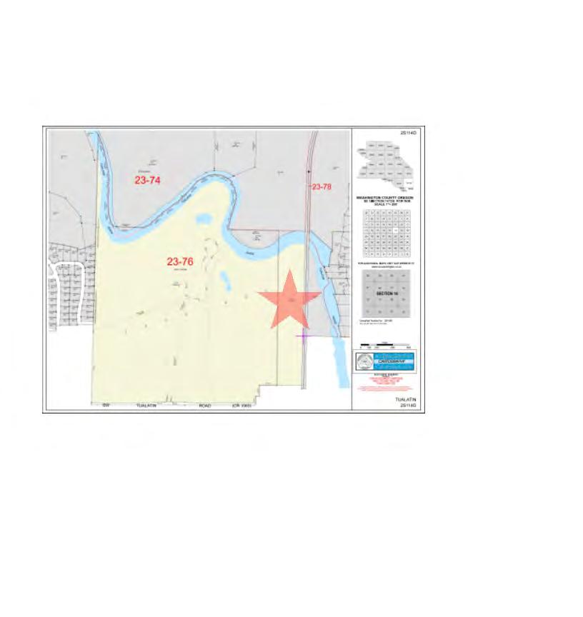
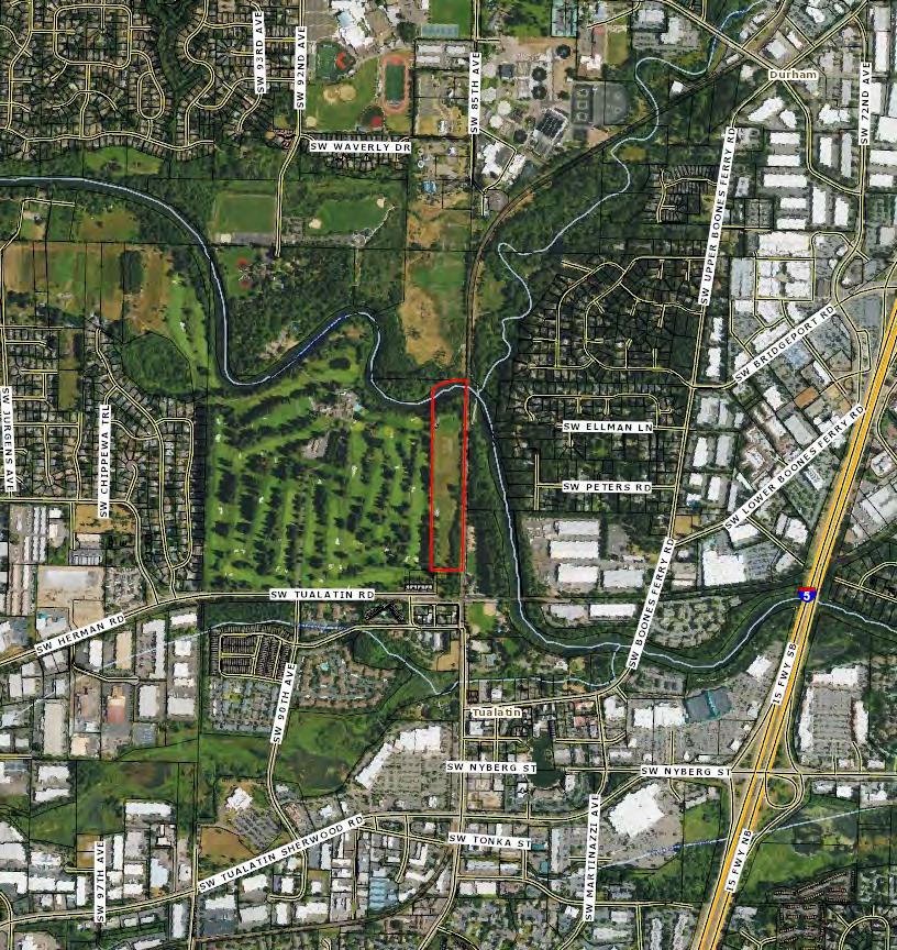
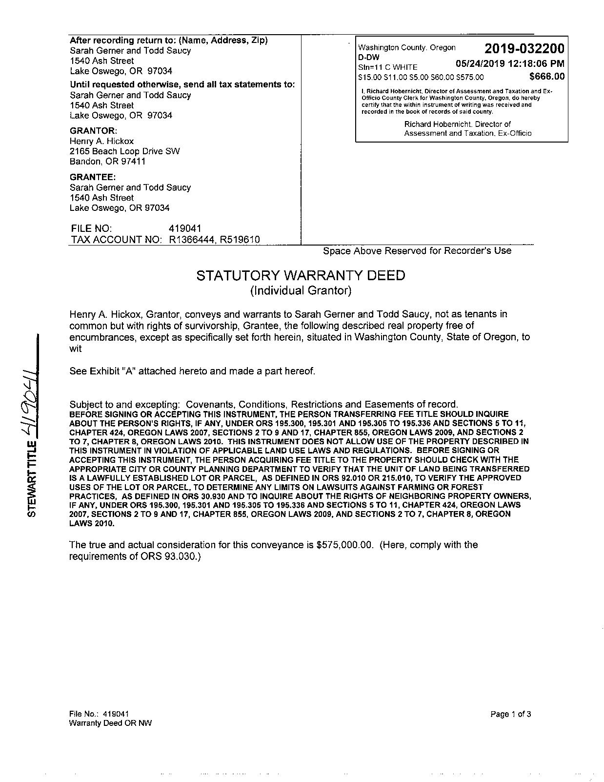
TAX ID: 2S114D000300, 2S123AA01900, 2S123AA00100 & 2S123AA00200
TUALATIN, OR 97062 DEVELOPER PACKET

Compliments of WFG National Title Insurance Company Customer Service Department

Property Details
Utility As-Builts (Water & Sewer)
Zoning Information
Custom Maps CONTENTS The information contained is provided by WFG’s Customer Service Department to our customers, and while deemed reliable, is not guaranteed.
TABLE OF
Assessors Tax Map
PROPERTY Property Information
information contained is provided by WFG’s Customer Service Department to our customers,
reliable,
not guaranteed.
Vesting Deed DETAILS The
and while deemed
is
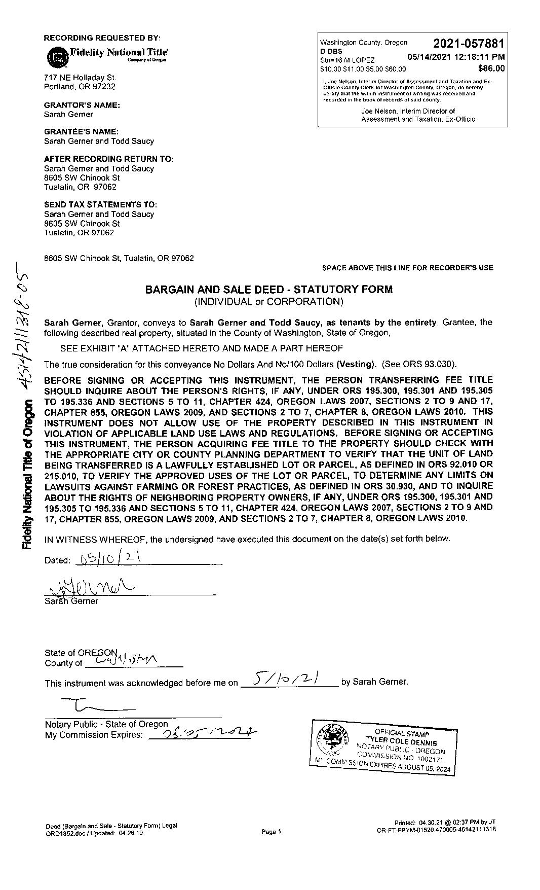
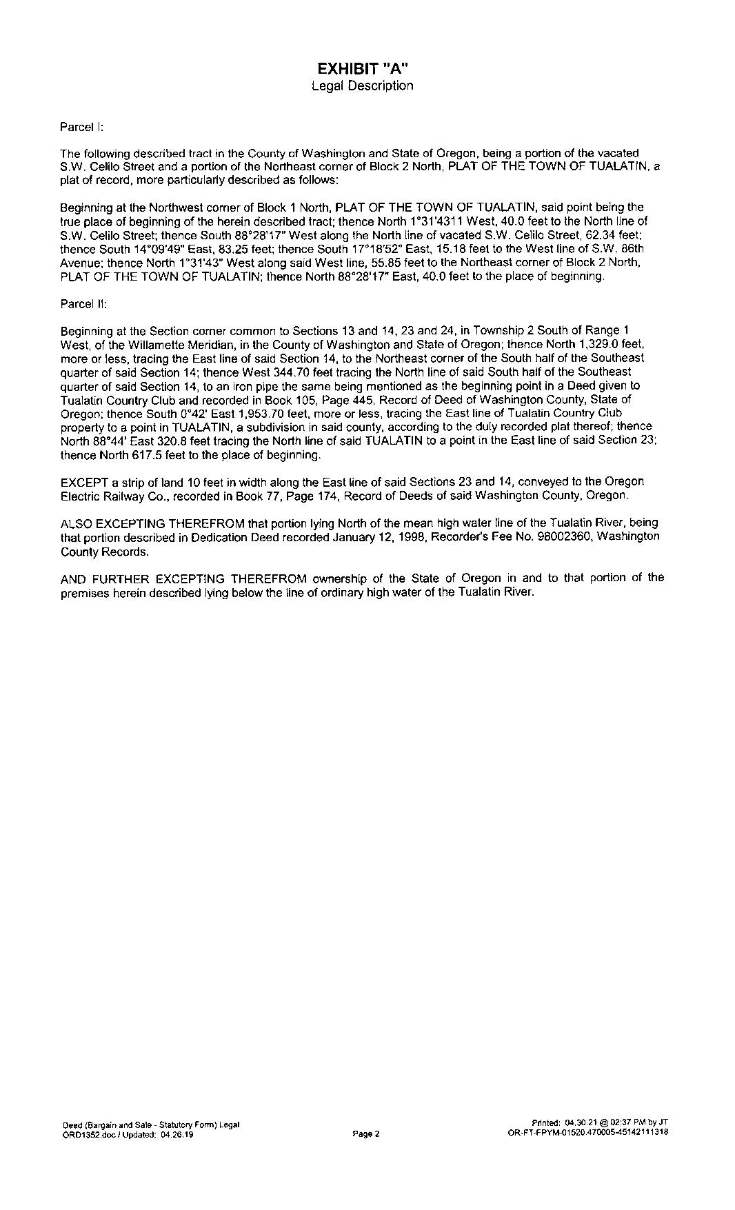
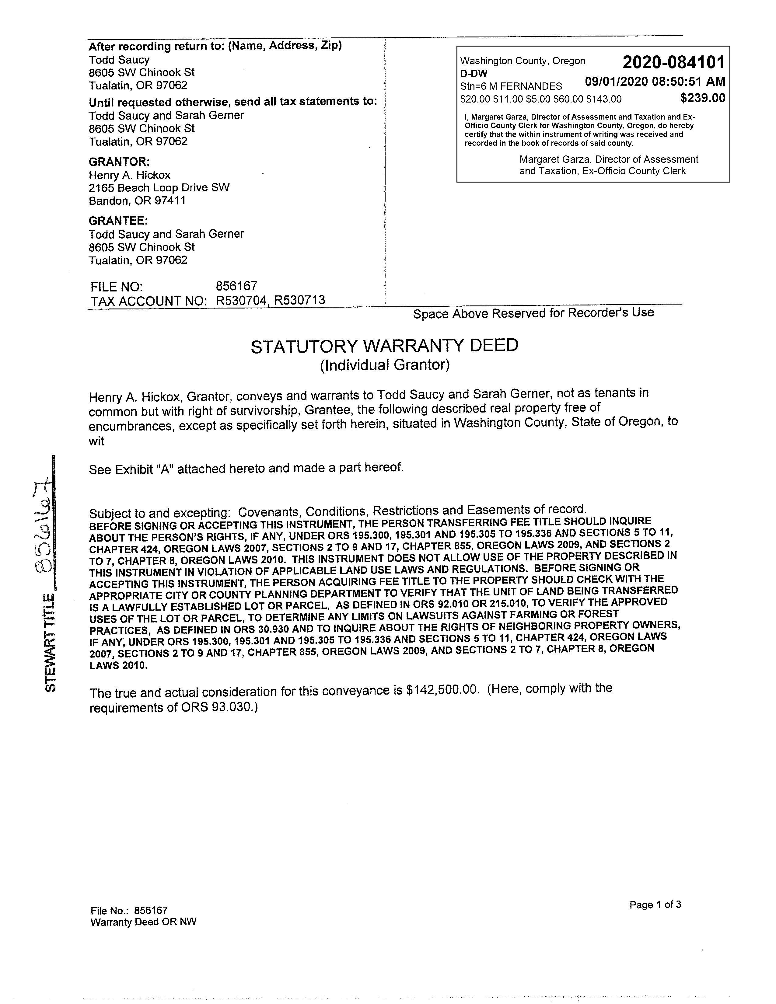
PropertyDetailReport
Owner:ToddSaucy&SarahGerner
Site:8605SWChinookStTualatinOR97062
Mail:8605SWChinookStTualatinOR97062
LocationandSiteInformation
County: Washington
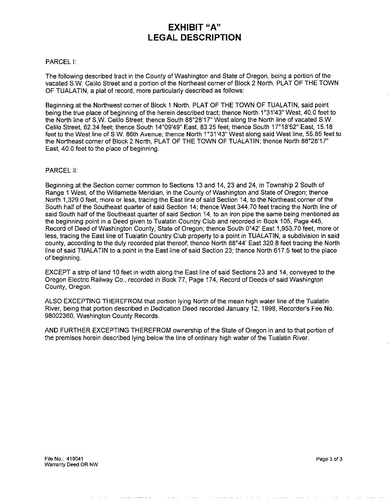
LegalDescription: ACRES14.16
APN: R519610
TaxLot: 2S114D000300
Twn-Rng-Sec: 02S/01W/14/SE
Neighborhood: Riverpark
Subdivision:
LegalLot/Block: 2/2

LotSqFt: 616,810
LotAcres: 14.16
LandUse: 1910-UrbanDevelopableTractImproved
LandUseSTD: FarmsAndCrops
CountyBldgUse: AFAR-ResidenceSingleFamily
#Dwellings:
MapPage/Grid: 685-F2
Zoning: Tualatin-RL
CensusTract/Block: 032001/1000 Watershed: FannoCreek-TualatinRiver
ElementarySchool: BridgeportElementarySchool HighSchool: TualatinHighSchool MiddleSchool: HazelbrookMiddleSchool SchoolDistrict: Tigard-Tualatin
PropertyCharacteristics
TotalLivingArea: 1,646 Bedrooms: 2 YearBuilt/Eff: 1960(1973) FirstFloorSqFt: 1,454 BathroomsTotal: 2 Heating: BaseboardElectric SecondFloorSqFt: 192 BathroomsFull/Half: Cooling: BasementFin/Unfin: Stories: Fireplace: 1
Fin/Unfin: Foundation: 01 Pool: GarageSqFt: RoofMaterial: WoodShake Kitchen:
MarketTotal: $1,054,080.00 PropertyTax: $6,818.90 MarketLand: $898,480.00 Exemption: MarketStructure: $155,600.00 MarketImproved%: 15.00% AsssessmentYear: 2023 LevyCode: 23.76 AssessedTotal: $388,060.00 MillRate: 17.5718
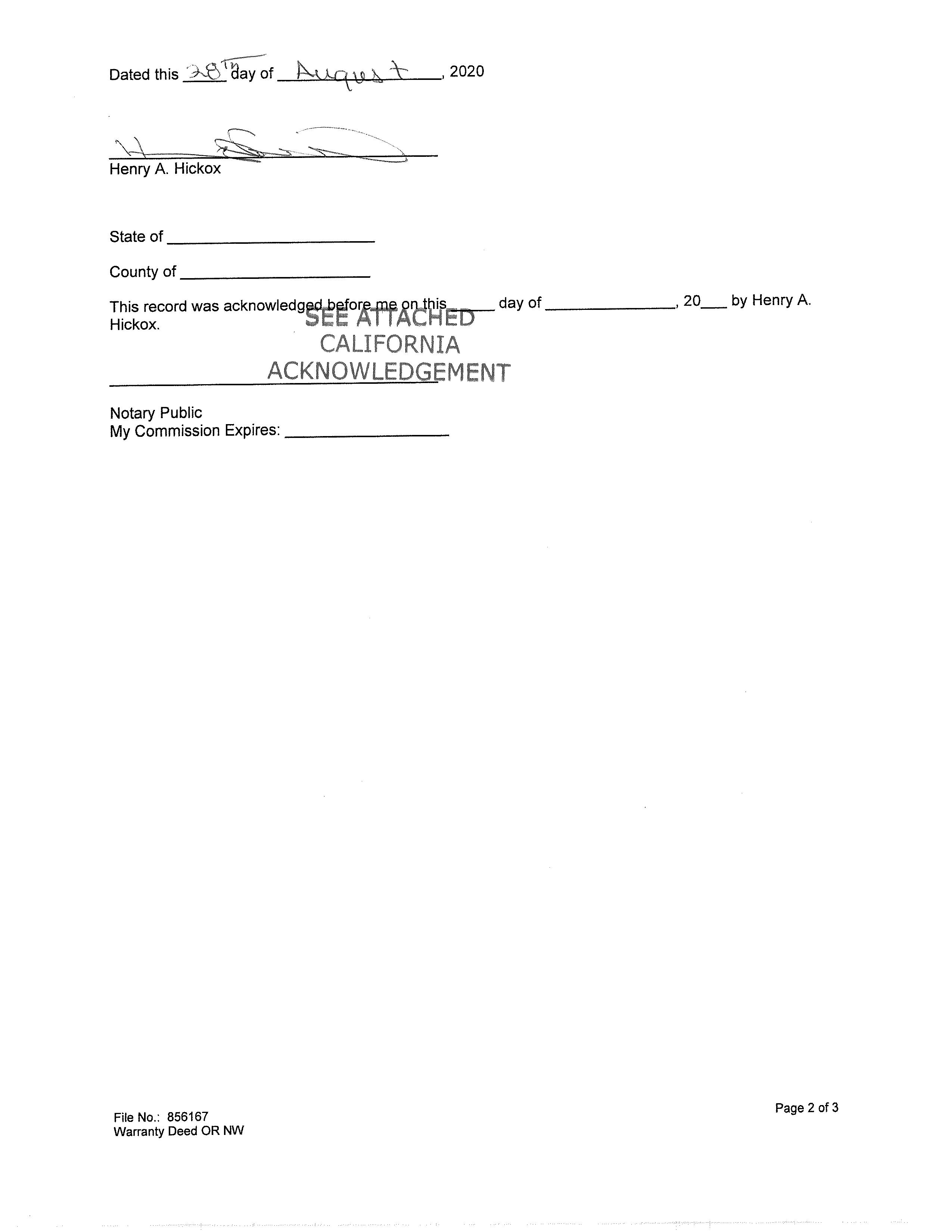
andLoanInformation SaleDate: 05/14/2021 Lender: NEWREZLLC SaleAmount: LoanAmount: $456,000.00 Document#: 57881 LoanType: Conventional DeedType: Deed Price/SqFt: $0.00 TitleCo: FIDELITYNAT'LTITLE/OREGON SellerName: GERNERSARAH PreparedBy:WFGNationalTitleCustomerServiceDepartment 12909SW68thPkwy,Suite350,Portland,OR97223 P:5036031700|3608915474E:cs@wfgnationaltitle.com|cccs@wfgtitle.com SentryDynamics,Inc.anditscustomersmakenorepresentation,warrantiesorconditions,expressorimplied, astotheaccuracyorcompletenessofinformationcontainedinthisreport.
Attic
AssessmentandTaxInformation
Sale
AssessorMap ParcelID:R519610 SiteAddress:8605SWChinookSt SentryDynamics,Inc.anditscustomersmakenorepresentations, warrantiesorconditions,expressorimplied,astotheaccuracyor completenessofinformationcontainedinthisreport.
ParcelID:R519610
SentryDynamics,Inc.anditscustomersmakenorepresentations, warrantiesorconditions,expressorimplied,astotheaccuracyor completenessofinformationcontainedinthisreport.
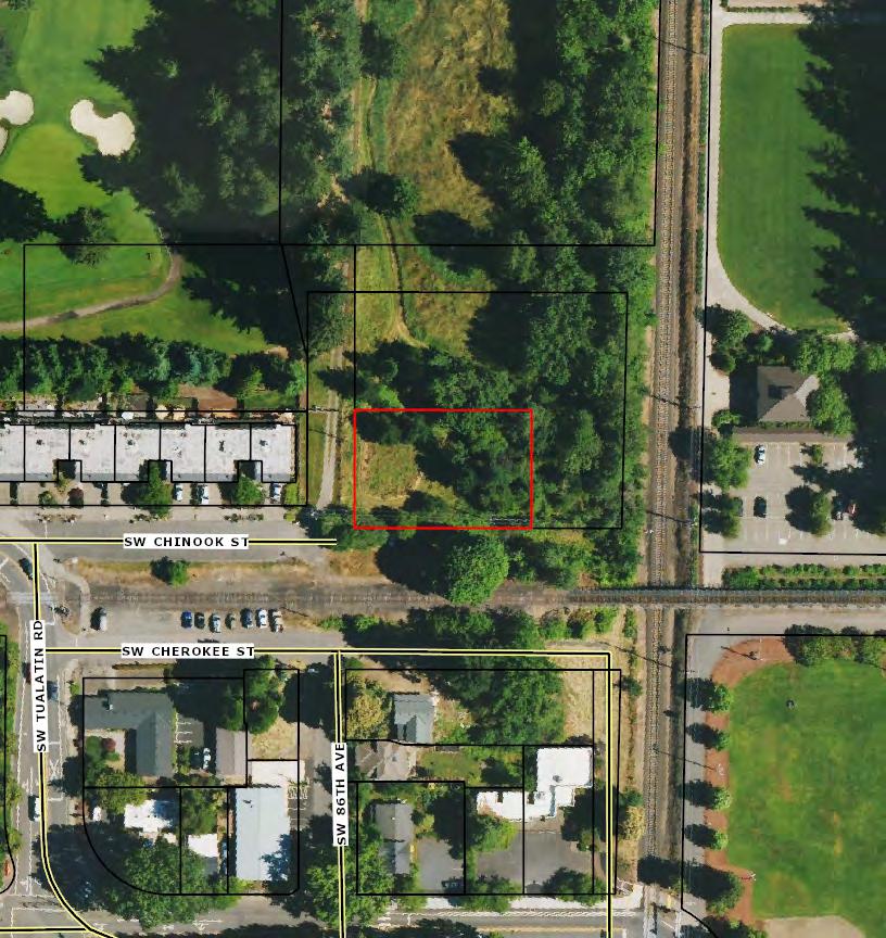
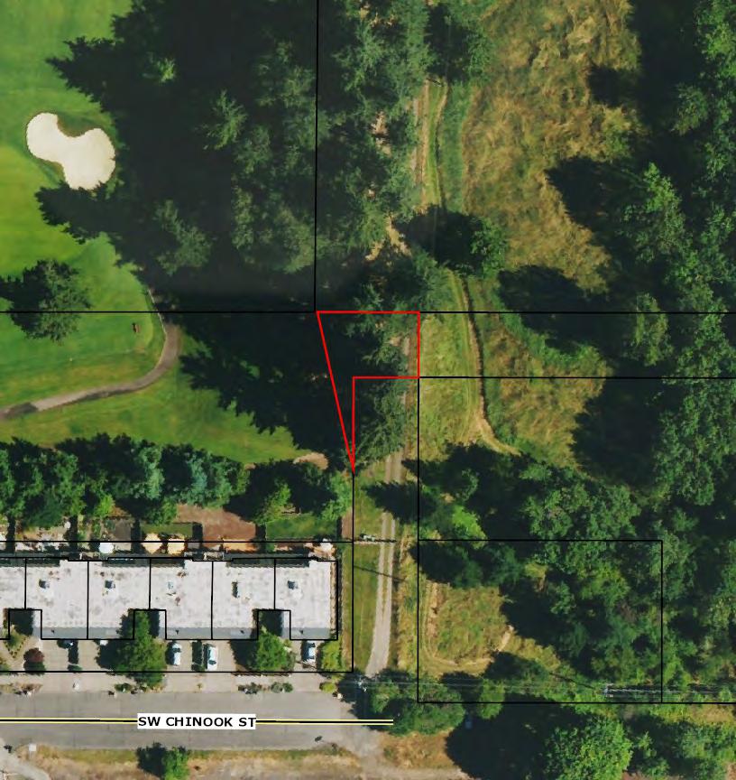
AerialMap
PropertyDetailReport
Owner:ToddSaucy&SarahGerner
Site:NsTualatinOR97062
Mail:8605SWChinookStTualatinOR97062
LocationandSiteInformation
County: Washington
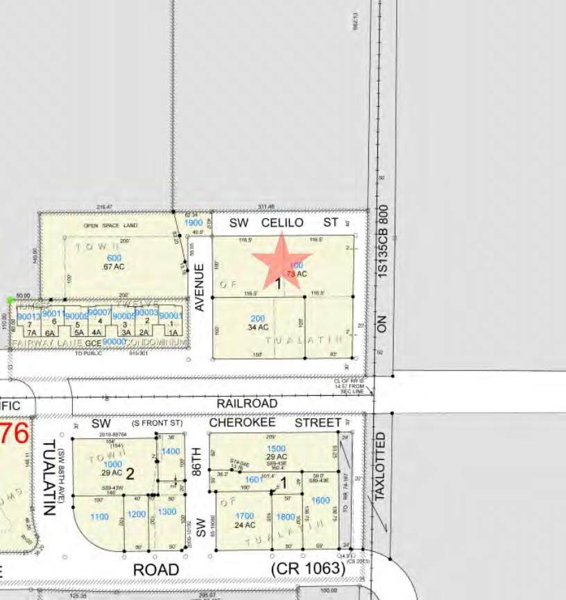
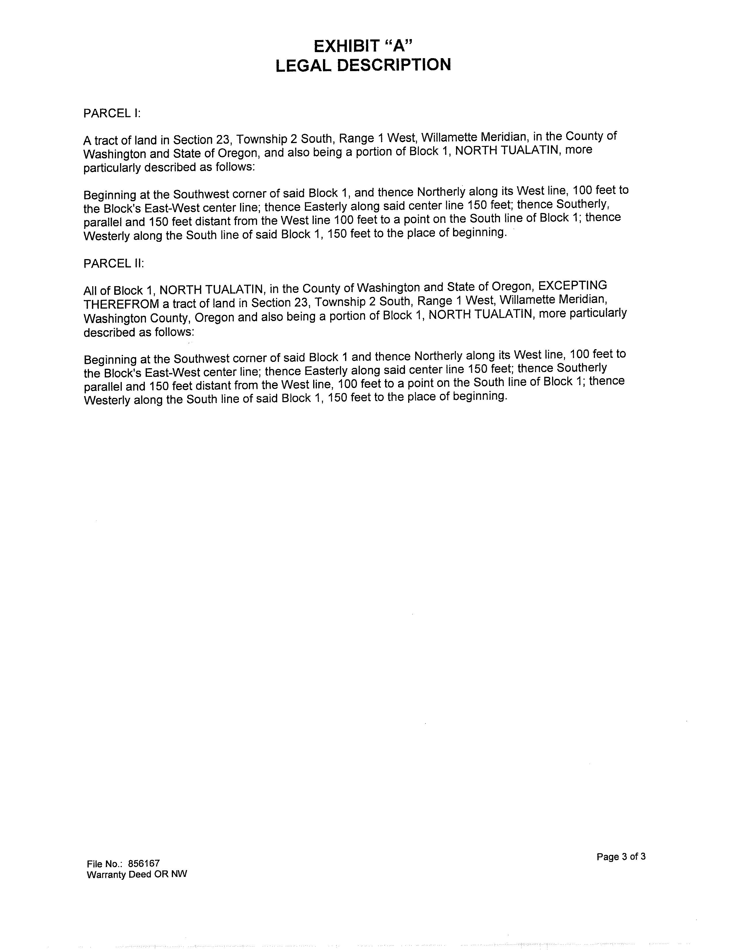
LegalDescription: TUALATIN,TOWNOF,BLOCKPT1N, ACRES0.73
APN: R530704
TaxLot: 2S123AA00100
Twn-Rng-Sec: 02S/01W/23/NE
LotSqFt: 31,799
LotAcres: 0.73
LandUse: 1900-UrbanDevelopableTract-Vacant
LandUseSTD: Condominium,Pud
CountyBldgUse: RCON
Neighborhood: Riverpark #Dwellings:
Subdivision: Tualatin
LegalLot/Block: 1N
MapPage/Grid: 685-F3
Zoning: Tualatin-RML
CensusTract/Block: 032001/1000 Watershed: FannoCreek-TualatinRiver
ElementarySchool: BridgeportElementarySchool HighSchool: TualatinHighSchool MiddleSchool: HazelbrookMiddleSchool SchoolDistrict: Tigard-Tualatin
PropertyCharacteristics
TotalLivingArea: Bedrooms: YearBuilt/Eff: FirstFloorSqFt: BathroomsTotal: Heating: SecondFloorSqFt: BathroomsFull/Half: Cooling: Basement
Stories: Fireplace:
Foundation: Pool: GarageSqFt: RoofMaterial: Kitchen:
MarketTotal: $53,050.00 PropertyTax: $859.17 MarketLand: $53,050.00 Exemption: MarketStructure: MarketImproved%: AsssessmentYear: 2023 LevyCode: 23.76 AssessedTotal: $53,050.00 MillRate: 17.5718 SaleandLoanInformation SaleDate: 09/01/2020 Lender: SaleAmount: $142,500.00 LoanAmount: Document#: 2020084101 LoanType: DeedType: Deed Price/SqFt: $0.00 TitleCo: SellerName: HICKOX,HENRYA PreparedBy:WFGNationalTitleCustomerServiceDepartment 12909SW68thPkwy,Suite350,Portland,OR97223 P:5036031700|3608915474E:cs@wfgnationaltitle.com|cccs@wfgtitle.com SentryDynamics,Inc.anditscustomersmakenorepresentation,warrantiesorconditions,expressorimplied, astotheaccuracyorcompletenessofinformationcontainedinthisreport.
Fin/Unfin:
AtticFin/Unfin:
AssessmentandTaxInformation
AssessorMap ParcelID:R530704 SiteAddress:Ns SentryDynamics,Inc.anditscustomersmakenorepresentations, warrantiesorconditions,expressorimplied,astotheaccuracyor completenessofinformationcontainedinthisreport.

AerialMap
ID:R530704
Dynamics,Inc.anditscustomersmakenorepresentations,
conditions,expressorimplied,astotheaccuracyor
information
thisreport.
Parcel
Sentry
warrantiesor
completenessof
containedin

PropertyDetailReport
Owner:ToddSaucy&SarahGerner
Site:NsTualatinOR97062
Mail:8605SWChinookStTualatinOR97062
LocationandSiteInformation
County: Washington
LegalDescription: TUALATIN,TOWNOF,BLOCKPT1N, ACRES0.34
APN: R530713
TaxLot: 2S123AA00200
Twn-Rng-Sec: 02S/01W/23/NE
LotSqFt: 14,810
LotAcres: 0.34
LandUse: 1900-UrbanDevelopableTract-Vacant
LandUseSTD: Condominium,Pud
CountyBldgUse: RCON
Neighborhood: Riverpark #Dwellings:
Subdivision: Tualatin
LegalLot/Block: 1N
MapPage/Grid: 685-F3
Zoning: Tualatin-RL
CensusTract/Block: 032001/1000 Watershed: FannoCreek-TualatinRiver
ElementarySchool: BridgeportElementarySchool HighSchool: TualatinHighSchool
MiddleSchool: HazelbrookMiddleSchool SchoolDistrict: Tigard-Tualatin
PropertyCharacteristics
TotalLivingArea: Bedrooms: YearBuilt/Eff: FirstFloorSqFt: BathroomsTotal: Heating: SecondFloorSqFt: BathroomsFull/Half: Cooling: Basement
Stories: Fireplace:
Foundation: Pool: GarageSqFt: RoofMaterial: Kitchen:
MarketTotal: $88,460.00 PropertyTax: $1,191.37 MarketLand: $88,460.00 Exemption: MarketStructure: MarketImproved%: AsssessmentYear: 2023 LevyCode: 23.76 AssessedTotal: $67,800.00 MillRate: 17.5718 SaleandLoanInformation SaleDate: 09/01/2020 Lender: SaleAmount: $142,500.00 LoanAmount: Document#: 2020084101 LoanType: DeedType: Deed Price/SqFt: $0.00 TitleCo: SellerName: HICKOX,HENRYA PreparedBy:WFGNationalTitleCustomerServiceDepartment 12909SW68thPkwy,Suite350,Portland,OR97223 P:5036031700|3608915474E:cs@wfgnationaltitle.com|cccs@wfgtitle.com SentryDynamics,Inc.anditscustomersmakenorepresentation,warrantiesorconditions,expressorimplied, astotheaccuracyorcompletenessofinformationcontainedinthisreport.
Fin/Unfin:
AtticFin/Unfin:
AssessmentandTaxInformation
AssessorMap ParcelID:R530713 SiteAddress:Ns SentryDynamics,Inc.anditscustomersmakenorepresentations, warrantiesorconditions,expressorimplied,astotheaccuracyor completenessofinformationcontainedinthisreport.
AerialMap ParcelID:R530713 SentryDynamics,Inc.anditscustomersmakenorepresentations, warrantiesorconditions,expressorimplied,astotheaccuracyor completenessofinformationcontainedinthisreport.
PropertyDetailReport
Owner:ToddSaucy&SarahGerner
Site:NsTualatinOR97062
Mail:8605SWChinookStTualatinOR97062
LocationandSiteInformation
County: Washington
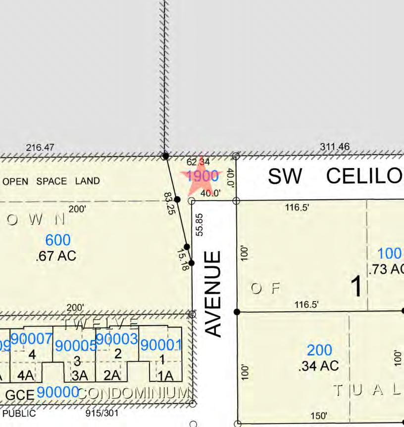
LegalDescription: TUALATIN,TOWNOF,BLOCKPT1S, ACRES0.06
APN: R1366444
TaxLot: 2S123AA01900
Twn-Rng-Sec: 02S/01W/23/NE
LotSqFt: 2,614
LotAcres: 0.06
LandUse: 1900-UrbanDevelopableTract-Vacant
LandUseSTD: Condominium,Pud
CountyBldgUse: RCON
Neighborhood: Riverpark #Dwellings:
Subdivision: Tualatin
LegalLot/Block: 1S
MapPage/Grid: 685-F3
Zoning: Tualatin-RML
CensusTract/Block: 032001/1000 Watershed: FannoCreek-TualatinRiver
ElementarySchool: BridgeportElementarySchool HighSchool: TualatinHighSchool
MiddleSchool: HazelbrookMiddleSchool SchoolDistrict: Tigard-Tualatin
PropertyCharacteristics
TotalLivingArea: Bedrooms: YearBuilt/Eff: FirstFloorSqFt: BathroomsTotal: Heating: SecondFloorSqFt: BathroomsFull/Half: Cooling:
BasementFin/Unfin: Stories: Fireplace:
SqFt: RoofMaterial: Kitchen:
AtticFin/Unfin: Foundation: Pool: Garage
MarketTotal: $1,500.00 PropertyTax: $4.03 MarketLand: $1,500.00 Exemption: MarketStructure: MarketImproved%: AsssessmentYear: 2023 LevyCode: 23.76 AssessedTotal: $230.00 MillRate: 17.5718
andLoanInformation SaleDate: 05/24/2019 Lender: SaleAmount: $575,000.00 LoanAmount: $0.00 Document#: 32200 LoanType: DeedType: Deed Price/SqFt: $0.00 TitleCo: STEWARTTITLE SellerName: HICKOXHENRYA PreparedBy:WFGNationalTitleCustomerServiceDepartment 12909SW68thPkwy,Suite350,Portland,OR97223 P:5036031700|3608915474E:cs@wfgnationaltitle.com|cccs@wfgtitle.com SentryDynamics,Inc.anditscustomersmakenorepresentation,warrantiesorconditions,expressorimplied, astotheaccuracyorcompletenessofinformationcontainedinthisreport.
AssessmentandTaxInformation
Sale
AssessorMap ParcelID:R1366444 SiteAddress:Ns SentryDynamics,Inc.anditscustomersmakenorepresentations, warrantiesorconditions,expressorimplied,astotheaccuracyor completenessofinformationcontainedinthisreport.
ParcelID:R1366444
SentryDynamics,Inc.anditscustomersmakenorepresentations, warrantiesorconditions,expressorimplied,astotheaccuracyor completenessofinformationcontainedinthisreport.
AerialMap

Water As-Built Maps
City of Tualatin
Sewer As-Built Maps
UTILITY
s
Clean Water Services AS - BUILTS The information contained is provided by WFG’
Customer Service Department to our customers, and while deemed reliable, is not guaranteed.
SEWER LINE MAP
This map is a copy of public record and is provided solely for informational purposes.
WFG National Title assumes no liability for variations, if any, in dimensions, area or location of the premises or the location of improvements.
ZONING
DETAILS
Detailed Zoning Information
2S123AA00100 & 2S123AA01900
Tualatin—RML (Medium Low Density Residential)
2S123AA00200 & 2S114D000300
Tualatin—RL (Low Density Residential)
Zoning Map
Community Jurisdiction
The information contained is provided by WFG’s Customer Service Department to our customers, and while deemed reliable, is not guaranteed.
TDC 41.100. - Purpose.
The purpose of this zone is to provide household living uses with a variety of housing types at moderately low densities. This district is primarily oriented toward middle housing types including attached dwellings, multifamily development, and manufactured dwelling parks.
( Ord. No. 1463-21 , § 17, 12-13-21)
TDC 41.200. - Use Categories.
UseCategories.Table 41-1 lists use categories Permitted Outright (P) or Conditionally Permitted (C) in the RML zone. Use categories may also be designated as Limited (L) and subject to the limitations listed in Table 41-1 and restrictions identified in TDC 41.210. Limitations may restrict the specific type of use, location, size, or other characteristics of the use category. Use categories which are not listed are prohibited within the zone, except for uses which are found by the City Manager or appointee to be of a similar character and to meet the purpose of this zone, as provided in TDC 31.070.
OverlayZones.Additional uses may be allowed in a particular overlay zone. See the overlay zone Chapters for additional uses.
Use Categories in the RML Zone
(1) (2)
41 - MEDIUM LOW DENSITY RESIDENTIAL ZONE (RML)
CHAPTER
Table 41-1
USE CATEGORY STATUS LIMITATIONS AND CODE REFERENCES RESIDENTIAL USE CATEGORIES Household Living P/C Permitted housing types subject to TDC 41.220. Residential Accessory Uses P (L) Permitted uses limited to Family Child Care Home subject to ORS 329A.440. Group Living P/C (L) Permitted uses limited to •Residential Facility; and, •Nursing Facility. Conditional uses limited to Congregate Care Facility subject to TDC 34.020 and TDC 34.030. COMMERCIAL USE CATEGORIES
INSTITUTIONAL USE CATEGORIES
Assembly Facilities
C (L)
Conditional uses limited to places of religious worship. See TDC 34.800 Religious uses and ORS 227.500 pertaining to activities customarily associated with the practices of religious activity.
Basic Utilities
P/C (L)
Greenways and Natural Areas P
Parks and Open Areas
P/C (L)
Permitted uses limited to water or sewage pump stations and pressure reading stations.
Conditional uses limited to water reservoirs, with a maximum height of 75 feet.
Permitted uses limited to public park or playground.
Conditional uses limited to golf course or country club with golf course.
Agriculture C (L) Subject to TDC 41.210(1). Durable Goods Sales C (L) Conditional uses limited to nurseries. Retail Sales and Service C (L) Conditional uses limited to Child Day Care Center.
Community Services C Medical Center C (L) Conditional uses limited to a hospital. Schools C
INFRASTRUCTURE AND UTILITIES USE CATEGORIES
Safety Facilities C (L)
�re stations Transportation
P
Public
Conditional uses limited to
Facilities
TDC 41.210. - Additional Limitations on Uses.
AgriculturalUses.The following agricultural uses are allowed with a conditional use permit within areas designated on Comprehensive Plan Map 10-6:
Conditional Use of Agricultural Animals. Raising of agricultural animals, limited to cattle, horses and sheep.
The City Council may limit the number of animals to be allowed on a specific parcel of property; and Agricultural structures such as barns, stables, sheds, but excluding feed lots. Feed lots are prohibited. WirelessCommunicationFacilities.Wireless Communication Facilities may be permitted uses or conditional uses, depending on the nature of the use.
PermittedUses.The following uses are permitted outright:
Wireless Communication Facility Attached, provided the facility is not mounted on a single-family dwelling or its accessory structures; and
Wireless Communication Facility, provided the facility is located within 300 feet of the centerline of Interstate 5.
ConditionalUses.All other detached wireless communication facilities may be allowed with a conditional use permit. The facility must not be located within an approved small lot subdivision.
(Ord. No. 1450-20 , § 16, 12-14-20)
TDC 41.220. - Housing Types.
Table 41-2 lists Housing Types permitted in the RML zone. Housing types may be Permitted Outright (P), Conditionally Permitted (C), or Not Permitted (N) in the RML zone.
Table 41-2
Housing Types in the RML Zone
(1)
(i) (ii)
Facilities P/C (L)
(a) (b) (2) (a)
(b) Wireless Communication
Subject to TDC 41.210(2).
Maximum height and minimum setbacks subject to TDC Chapter 73F.
HOUSING TYPE STATUS LIMITATIONS AND CODE REFERENCES Single-Family Dwelling P Limited to single-family dwellings in a �exible lot subdivision subject to TDC 36.410. Accessory Dwelling Unit P Subject to TDC 73A.170 Duplex P See TDC de�nition in 31.060. Townhouse P See TDC de�nition in 31.060
(Ord. No. 1444-20 , § 1, 10-12-20; Ord. No. 1463-21 , § 18, 12-13-21)
TDC 41.300. - Development Standards.
Development standards in the RML zone are listed in Table 41-3. Additional standards may apply to some uses and situations, see TDC 41.310 and TDC 41.330. The standards in Table 41-3 may be modified for greenway and natural area dedications as provided in TDC 36.420. The standards for lot size, lot width, building coverage, and setbacks that apply to single-family dwellings in small lot subdivisions are provided in TDC 36.410(2)(b).
Exceptions.Existing non-conforming situations may be developed according to the provisions of TDC Chapter 35
(1) (2) Triplex P See TDC de�nition in 31.060 Quadplex P See TDC de�nition in 31.060. Cottage Cluster P See TDC de�nition in 31.060. Multi-Family Structure (5 or more units) P See TDC de�nition in 31.060. Manufacturing Dwelling N See TDC de�nition in 31.060 Manufactured Dwelling Park P Limited to locations designated by the Tualatin Community Plan Map and subject to TDC 34.190. Retirement Housing Facility C Subject to TDC 34.400. Residential Home P See TDC de�nition in 31.060.
Table 41-3
STANDARD REQUIREMENT LIMITATIONS AND CODE REFERENCES MAXIMUM DENSITY Single Family Dwellings 10 units per acre Duplex None Townhouse 25 units per acre
Development Standards in the RML Zone
MINIMUM LOT SIZE
Triplex None Quadplex None Cottage Cluster None Minimum density of 4 units per acre. Multi-Family (5 or more units) 10 units per acre Manufactured Dwelling Parks 12 units per acre Limited to single-wide dwelling parks or any part of a single-wide dwelling park. Retirement Housing Facility, or Congregate Care Facility 15 units per acre Nursing Facility 15 units per acre Group Living Uses 15 units per acre
Single Family Dwelling 3,000 square feet Only in a Flexible Lot Subdivisions, subject to TDC 36.410 Duplex 4,500 square feet May be reduced for Flexible Lot Subdivisions, subject to TDC 36.410 Townhouse 1,400 square feet Triplex 4,500 square feet May be reduced for Flexible Lot Subdivisions, subject to TDC 36.410. Quadplex 4,500 square feet May be reduced for Flexible Lot Subdivisions, subject to TDC 36.410 Cottage Cluster 4,500 square feet May be reduced for Flexible Lot Subdivisions, subject to TDC 36.410 Multi-Family Structure (5 or more units) 20,000 square feet
Flag Lots
Must be su�cient to comply with minimum access requirements of TDC 73C.
MINIMUM SETBACKS
Multi-Family Structure under Condominium Ownership 20,000 square feet Limited to the primary condominium lot. All Other Permitted Uses 10,000 square feet Conditional Uses 20,000 square feet Infrastructure and Utilities Uses As determined through the Subdivision, Partition, or Lot Line Adjustment process MINIMUM AVERAGE LOT WIDTH Single Family Detached 26 feet Only allowed for Flexible Lot Subdivisions, subject to TDC 36.410. Townhouse 14 feet Duplex, Triplex, Quadplex, and Cottage Clusters 50 feet May be reduced to 30 feet if on a cul-desac. May be reduced to 26 feet for Flexible Lot Subdivisions, subject to TDC 36.410. Multi-Family Structure 75 feet May be 40 feet on a cul-de-sac street. Multi-Family Structure under Condominium Ownership 100 feet Limited to the primary condominium lot. Minimum lot width at street is 40 feet. All Other Permitted Uses 75 feet Conditional Uses 100 feet Minimum lot width at street is 40 feet.
Single Family Detached, Duplex, Townhouse, Triplex, or Quadplex
Single Family Detached only in Flexible Lot Subdivisions, subject to TDC 36.410.
Zero-foot side setbacks permitted for lot or parcel lines where Townhouse units are attached.
Multi-family (5 or more units), Conditional Uses, and Other Permitted Uses Not Listed
Corner Lots
On corner lots, the setback is the same as the front yard setback on any side facing a street other than an alley except for duplexes, triplexes, and quadplexes where the setback is 10 feet.
Other Development Types
Front 10
Garage Door 20
5
feet
feet Side
feet
10
Rear
feet
Front <12 feet 20 feet 12—<25 feet 25 feet 25—<30 feet 30 feet 30+ feet 35 feet Side 5 feet
If all setbacks are equal to or greater than 1½ times the height of the building, the height may be increased to a maximum of 50 feet with a conditional use permit.
Cottage Cluster 10 feet on all sides Minimum distance of 10 feet between units in a cottage cluster. Minimum Distance Between Buildings within One Development 10 feet Parking and Vehicle Circulation Areas 10 feet For Townhouses, determined through the Architectural Review process Conditional Uses As determined through Architectural Review
no greater than 50 feet Any Yard Area Adjacent to Basalt Creek Parkway 50 feet MAXIMUM STRUCTURE HEIGHT All Uses 35 feet
process,
MAXIMUM LOT COVERAGE Duplex 60% Townhouse 75% Triplex 60% Quadplex 60% Cottage Cluster 75% All Other Permitted Uses 40% Conditional Uses 45%
(Ord. No. 1444-20 , § 2, 10-12-20; Ord. No. 1450-20 , § 17, 12-14-20; Ord. No. 1463-21 , § 19, 12-13-21)
TDC 41.310. - Projections Into Required Yards.
The following architectural features may project into a required front or rear yard setback area not more than three feet, and into a required side yard not more than two feet: cornices, eaves, canopies, decks, sun-shades, gutters, chimneys, flues, belt courses, leaders, sills, pilasters, lintels, ornamental features, and other similar architectural features.
TDC 41.320. - Density Bonus or Setback Reduction for Developments Adjacent to Greenways and Natural Areas.
To preserve natural areas and habitat for fish and wildlife, the decision-making authority may provide a density bonus or setback reduction for developments that are adjacent to Greenways or Natural Areas that dedicate land for conservation or public recreational purposes, in accordance with the following standards:
(1)
DensityBonus.The lot(s) may be developed to the same number of dwelling units that would be permitted in the RML zone if none of the land area in the Greenway or Natural Area lots were in a conservation or protection area.
(2)
SetbackReduction.All permitted uses may be allowed a reduction of up to 35 percent of the front, side or rear yard setbacks, as determined through the Architectural Review process, if as a result the buildings are farther away from fish and wildlife habitat areas. Single-Family Dwellings in Small Lot Subdivisions and setback areas that abut property lines in the RL zone are not eligible for the setback reduction.
(3)
LocationofGreenwayorNaturalAreaLot.A portion of the parcel must be located in one of the following conservation or protection areas:
(a)
(b)
Natural Resource Protection Overlay (NRPO) District (TDC Chapter 72); or Clean Water Services Vegetated Corridor.
(4)
OwnershipofGreenwayorNaturalAreaLot.The ownership of each Greenway or Natural Area Lot must be one of the following:
(a)
(b)
(c)
Dedicated to the City at the City's option;
Dedicated in a manner approved by the City to a non-profit conservation organization; or
Retained in private ownership.
(5)
OwnershipConsiderations.The decision-making authority must consider, but not limited to, the following factors when determining the appropriate ownership of the Greenway or Natural Area Lot:
(a)
Does the Park and Recreation Master Plan designate the lot for a greenway, pedestrian or bike path, public park, recreation, overlook or interpretive facility, or other public facility;
(b)
(c)
Does the lot include one or more designated Heritage Trees, or one or more significant trees;
Does the lot provide a significant view or esthetic element, or does it include a unique or intrinsically valuable element;
(d)
(e)
(f)
Does the lot connect publicly owned or publicly accessible properties;
Does the lot abut an existing park, greenway, natural area or other public facility;
Does the lot provide a public benefit or serve a public need;
(g)
(h)
(i) Does the lot contain environmental hazards; Geologic stability of the lot; and Future maintenance costs for the lot.
(Ord. 1414-18, 12-10-18; Ord. 1427-19 , § 19, 11-25-19)
TDC 41.330. - Reserved.
Editor's note— Ord. No. 1463, § 20, adopted December 13, 2021, repealed § 41.330. Former § 41.330 pertained to Development Standards for Single-Family Dwellings in a Small Lot Subdivision for Certain Basalt Creek Area Properties and derived from Ord. No. 1444-20 , § 3, adopted October 12, 2020.
TDC 40.100. - Purpose.
The purpose of the Low Density Residential (RL) zone is to provide low density residential areas in the City that are appropriate for dwellings on individual lots, as well as other miscellaneous land uses compatible with a low density residential environment.
TDC 40.200. - Use Categories.
UseCategories.Table 40-1 lists use categories Permitted Outright (P) or Conditionally Permitted (C) in the RL zone. Use categories may also be designated as Limited (L) and subject to the limitations listed in Table 40-1 and restrictions identified in TDC 40.210. Limitations may restrict the specific type of use, location, size, or other characteristics of the use category. Use categories which are not listed are prohibited within the zone, except for uses which are found by the City Manager or appointee to be of a similar character and to meet the purpose of this zone, as provided in TDC 31.070.
OverlayZones.Additional uses may be allowed in a particular overlay zone. See the overlay zone Chapters for additional uses.
40 - LOW DENSITY RESIDENTIAL ZONE (RL)
(1) (2) CHAPTER
Table 40-1
USE CATEGORY STATUS LIMITATIONS AND CODE REFERENCES RESIDENTIAL USE CATEGORIES Household Living P/C Permitted housing types subject to TDC 40.220. Residential Accessory Uses P (L) Home Occupations permitted subject to TDC 34.010 to 34.030 Family Child Care Home permitted. Subject to ORS 329A.440. Group Living P/C (L) Permitted uses limited to Residential Facility. Conditional uses limited to Congregate Care Facility subject to TDC 34.400.
Use Categories in the RL Zone
COMMERCIAL USE CATEGORIES
INSTITUTIONAL USE CATEGORIES
uses and ORS 227.500 pertaining to activities customarily associated with practices of religious activity.
Agriculture P/C (L) Subject to TDC 40.210(1). Durable Goods Sales C (L) Conditional uses limited to nurseries. Retail Sales and Service C (L) Conditional uses limited to Child Day Care Center.
Assembly Facilities C (L) Conditional uses limited to
religious
Religious
Community Services C Medical Center C (L) Conditional uses limited to a hospital. Schools C INFRASTRUCTURE AND UTILITIES USE CATEGORIES Basic Utilities P/C (L) Permitted uses limited to water or sewage pump stations and pressure reading stations. Conditional
Greenways and Natural Areas P
places of
worship. See TDC 34.800
uses limited to water reservoirs, with a maximum height of 75 feet.
Permitted uses limited to public park or playground.
Conditional uses limited to golf course or country club with golf course.
Permitted uses limited to a Wireless Communication Facility Attached, provided it is not mounted to a singlefamily dwelling or its accessory structures.
Maximum height and minimum setbacks subject to TDC Chapter 73F.
TDC 40.210. - Additional Limitations on Uses.
AgriculturalUses.Agricultural uses may be permitted uses or conditional uses depending on the nature of the use.
PermittedUses.The following uses are permitted outright:
Agricultural uses of land such as gardening and horticulture.
Raising of chickens as allowed by the Tualatin Municipal Code.
ConditionalUses.The following uses are conditional uses within areas designated on Comprehensive Plan Map 10-6:
ConditionalUseofAgriculturalAnimals.Raising of agricultural animals, limited to cattle, horses and sheep. The City Council may limit the number of animals to be allowed on a specific parcel of property.
Agriculturalstructuressuchasbarns,stables,sheds,butexcludingfeedlots.Feed lots are prohibited. (Ord. No. 1450-20 , § 14, 12-14-20)
TDC 40.220. - Housing Types.
Table 40-2 lists housing types permitted in the RL zone. Housing types may be Permitted Outright (P), Conditionally Permitted (C), or Not Permitted (N).
(1) (a) (i) (ii) (b) (i) (ii)
P/C (L)
Parks and Open Areas
Safety Facilities C (L)
Transportation Facilities P Wireless Communication Facilities P (L)
Public
Conditional uses limited to �re stations.
( Ord. No. 1463-21 , § 14, 12-13-21)
TDC 40.300. - Development Standards.
Development standards in the RL zone are listed in Table 40-3. Additional standards may apply to some uses and situations, see TDC 40.310. The standards in Table 40-3 may be modified for flexible lot subdivisions as provided in TDC 36.410 and for greenway and natural area dedications as provided in TDC 36.420
Exceptions.Existing nonconforming situations may be developed according to the provisions of TDC Chapter 35.
(1) (2)
40-2 Housing Types in the RL Zone HOUSING TYPE STATUS LIMITATIONS
CODE REFERENCES Single-Family Dwelling P/L Single-family dwellings in a small lot subdivision permitted, subject to TDC 36.410 Accessory Dwelling Unit P Subject to TDC 73A.170. Duplex P See TDC de�nition in 31.060 Townhouse P See TDC de�nition in 31.060 Triplex P See TDC de�nition in 31.060 Quadplex P See TDC de�nition in 31.060 Cottage Cluster P See TDC de�nition in 31.060 Multi-Family Structure C See TDC de�nition in 31.060 Manufactured Dwelling P Subject to TDC 40.300(4) Manufactured Dwelling Park N Retirement Housing Facility C Subject to TDC 34.400 Residential Home P See TDC de�nition in 31.060
Table
AND
Single-Family Dwelling Maximum: 6.4 units per acre Minimum: 1 unit per acre Duplex None Townhouse 25 units per acre Triplex None Quadplex None Cottage Cluster None Minimum density of 4 units per acre. Retirement Housing or Congregate Care Facility 10 units per acre
Single-Family Dwelling Average of 6,500 square feet May be reduced for Flexible Lot Subdivisions, subject to TDC 36.410, or Greenway and Natural Area dedications, subject to TDC 36.420 Duplex 6,500 square feet May be reduced for Flexible Lot Subdivisions, subject to TDC 36.410. Townhouse 1,400 square feet
Table 40-3 Development Standards in the RL Zone STANDARD REQUIREMENT LIMITATIONS AND CODE REFERENCES MAXIMUM DENSITY
MINIMUM LOT SIZE
MINIMUM LOT WIDTH
Triplex 6,500 square feet May be reduced for Flexible Lot Subdivisions, subject to TDC 36.410. Quadplex 6,500 square feet May be reduced for Flexible Lot Subdivisions, subject to TDC 36.410. Cottage Cluster 6,500 square feet May be reduced for Flexible Lot Subdivisions, subject to TDC 36.410 Conditional Uses 6,000 square feet Infrastructure and Utilities Uses As determined through the Subdivision, Partition, or Lot Line Adjustment process.
Single-Family Dwelling 50 feet May be reduced to 30 feet if on a cul-de-sac. Average minimum lot width is 30 feet. Duplex, Triplex, Quadplex, and Cottage Clusters 50 feet May be reduced to 30 feet if on a cul-de-sac. Average minimum lot width is 30 feet. Townhouse None
Conditional Uses
50 feet
Flag Lots
May be reduced to 30 feet if on a cul-de-sac.
Average minimum lot width is 30 feet.
Must be su�cient to comply with minimum access requirements of TDC 73C.
MINIMUM SETBACKS
Front
Secondary Frontage on Corner Lot
15 feet
10 feet
Garage Door
Side
May be reduced to 12 feet if to an unenclosed porch.
The secondary frontage is determined by the orientation of the structure, based on the location of the front door.
20 feet
5 feet
Zero-foot side setbacks permitted for lot or parcel lines where Townhouse units are attached.
Rear
Conditional Uses
15 feet
As determined through Architectural Review process. No minimum setback must be greater than 50 feet. Parking and vehicular circulation areas must be set back a minimum of ten feet from any public right-of-way or property line.
feet through Type II Architectural Review if all setbacks are not less than 1½ times the height of the building.
Yard Area Adjacent to Basalt Creek Parkway 50 feet MAXIMUM STRUCTURE HEIGHT All Uses 35 feet
be increased
50
MAXIMUM LOT COVERAGE Single Family Dwelling 45% Duplex 45% Townhouse 75% Triplex 60% Quadplex 60% Cottage Cluster 75% Conditional Uses 40%
Single Family Dwelling, Duplex, Townhouse, Triplex, Quadplex
Lot size 3,000 sf or less 3,001 to 5,000 sf 5,001 to 10,000 sf 10,001 to 19,999 sf 20,000 sf or more Maximum FAR 1.4 to 1 1.1 to 1 0.7 to 1 0.6 to 1 0.4 to 1 (Ord. No. 1450-20 , § 15, 12-14-20; Ord. No. 1463-21 , § 15, 12-13-21)
Any
May
to a maximum of
MAXIMUM FLOOR AREA RATION (FAR)
FAR does not apply to Cottage Clusters.
TDC 40.310. - Projections Into Required Yards.
The following architectural features may project into a required front or rear yard setback area not more than three feet, and into a required side yard not more than two feet: cornices, eaves, canopies, decks, sun-shades, gutters, chimneys, flues, belt courses, leaders, sills, pilasters, lintels, ornamental features, and other similar architectural features.
TDC 40.320. - Additional Development Standards.
(1) (2) (3)
FlexibleLotSubdivisions.The minimum lot size and other development standards for single-family dwellings in the RL zone may be reduced or modified for lots included as part of a flexible lot subdivision. See TDC 36.410.
GreenwayandNaturalAreaDedications.The minimum lot size and other development standards for singlefamily dwellings in the RL zone may be reduced or modified if land is dedicated for a Greenway or Natural Area. See TDC 36.420.
ManufacturedHomes.Except for manufactured homes placed in manufactured dwelling parks, manufactured homes must meet the following standards:
(a)
MinimumSize.The manufactured home must be multi-sectional and enclose a space of not less than 1,000 square feet. A manufactured home is not considered multi-sectional by having a tip-out section.
(b)
FoundationRequirements.The manufactured home must be placed on an excavated and back-filled foundation and enclosed at the perimeter such that the manufactured home is located not less than 1 foot above grade. However, a structural concrete foundation (such as that for a single-family dwelling) is not required.
(c)
RoofFormandMaterials.The manufactured home must have a pitched roof with a minimum slope of one foot in height for each four feet of width. The roof must be comprised of shingles, wood shakes, tiles, or other materials which create a similar appearance. Exposed flat, corrugated or ribbed sheet metal, fiberglass, or other materials similar in form or appearance cannot be used as roofing material but may be used for corner and edge flashing.
(d)
InsulationRequirements.The manufactured home must be certified by the manufacturer to have exterior thermal envelope meeting performance standards which reduce heat loss to levels equivalent to the performance standards required of single family dwellings constructed under the State Building Code.
(e)
GarageRequirement.The manufactured home must have an attached or detached two-car garage constructed of materials similar to the manufactured home.
( Ord. No. 1463-21 , § 16, 12-13-21)

G G G IP IP MF MF OP OP OP OP SF SF SF SF SF SF SF SF SF I-P I-P MUC-1 PR R-4.5 CC CG CG CG CO CO CO CO MG MG ML ML ML ML MUC MUC RH RH RH/HR RL RMH RML RML RML SW BOONES FERRY RD B R I D G E P O R T V I L L A G E S W TUA LATIN RD S W C H E Y E N N E W A Y BRIDGEPORT VILLAGE WS R I V E N D ELLDR B R I D G E P O RTVILLAGE W E S T E N T R SW ELLMAN LN SW BRIDGEPORT RD SW SW EEK DR SW TANOAK LN SW KINGFISHERWA Y SW SENECA ST SW 80 TH PL S W 7 9 T H P L S W 9 3 R D T E R SW 8 1ST PL SW 92NDTER SWTOOKBANKCT SW LOWERBOONES FERRY RD SWARKENSTONE DR SW BINDDALE CT SWCHILDS RD BRIDGEPORT VILLAGE S W U P PE R BOONE S FERRY RD SW WILDERLAND CT SW P ETERS RD SW SENECA ST SWWILLOWBOTTOM WAY SW 86TH AVE S W CHER O K E E S T SW CHINOOK S T SW FINDLAY RD SW FINDLAY DR SW WOODY END SW 84TH AV E SW MARTIN A ZZI AVE S W B R A N D Y SHIRE C T SW CASCARA LN SW 90TH AVE S W C H I P P E W A T R L SW 91ST TER SWSIOUX C T S W 9 2ND AVE BRIDGEPORT VILLAGE SWPAWNEE PATH SWHERMANRD NYBERG-I5RAMPWB I5NYBERGRAMP SB SW PETERS RD S W S H A W NE E T R L This map is a copy of public record and is provided solely for information purposes. WFG National Title assumes no liability for variations, if any, in dimensions, area or location of the premises or the location of improvements. Customer Service Department 12909 SW 68th Parkway, Suite 350 Portland, OR 97223 (503) 603-1700 cs@wfgnationaltitle.com 0380760 190 Feet Zoning Subject Property Tax Lots Commercial Industrial Multi Family Mixed Use Residential Parks & Open Spaces Single Family ²
2S123AA00100


Washington County T2S R1W S23 Latitude: 45.387873
INFORMATION Tax Lot ID: R Number: Tax Lot Size: Building Area Market Total Value Land Use Year Built Sale Date Sale Price Market Land Value Market Building Value State General Property Class County Tax Code 023.76 Site Address POLITICAL BOUNDARIES Jurisdiction TUALATIN Neighborhood Riverpark Voting Precinct 423.00000000 Metro Council District 3 Metro Councilor Gerritt Rosenthal Metro Councilor Email gerritt.rosenthal@oregonmetro.gov US Congressional District 6 Oregon House District 37 Oregon Senate District 19 LAND USE AND PLANNING Local Zoning RML Generalized Zoning MFR Classi�ed Zoning MFR1 Watershed Fanno Creek-Tualatin River +20 m 50 ft Lea�et (http://lea�etjs.com) | Tiles: © Metro RLIS
TAXLOT

drc@oregonmetro.gov
© Oregon Metro www.oregonmetro.gov/rlis
This Web site is offered as a public service, integrating various government records into a region-wide mapping system. The property assessment records are a multi-county integration of Clackamas, Multnomah and Washington County records. MetroMap blends each county's records into a common database on a quarterly basis. Therefore, to view each county's of�cial records, go to their respective web sites or of�ces. The other MetroMap data are derived from city, county, state, federal and Metro sources. The metadata (data about the data) are included on this site, including the sources to be consulted for veri�cation of the information contained herein. It describes some cases where Metro blends city and
Sub-Watershed Saum Creek-Tualatin River Basin Willamette Sub-Basin Tualatin Flood Plain Inside Wetland TUALATIN Urban Growth Boundary Inside Urban/Rural Reserve Reserve Name USGS Quad Name Beaverton SERVICE DISTRICTS Garbage Hauler Republic Services Commercial Hauler Republic Services Dropbox Provider Republic Services School District TIGARD-TUALATIN School District Number 23J Oregon Dept. of Ed. Dist. ID 2242 Natl. Center for Ed. Statistics Dist. ID 4112240 Water District Park District Tigard-Tualatin Aquatic District Sewer District Clean Water Services District Fire District Tualatin Valley Fire and Rescue District Fire Management Zone 6085 CENSUS INFORMATION Census Tract 32001.00000000 Census Block Group 1 Census Block Population (2010) 1100 Data Resource Center 600 Northeast Grand Avenue, Portland, OR 97232 503-797-1742
2S123AA01900

Washington County T2S R1W S23 Latitude: 45.388054
INFORMATION Tax Lot ID: R Number: Tax Lot Size: Building Area Market Total Value Land Use Year Built Sale Date Sale Price Market Land Value Market Building Value State General Property Class County Tax Code Site Address POLITICAL BOUNDARIES Jurisdiction Neighborhood Riverpark Voting Precinct 423.00000000 Metro Council District 3 Metro Councilor Gerritt Rosenthal Metro Councilor Email gerritt.rosenthal@oregonmetro.gov US Congressional District 6 Oregon House District 37 Oregon Senate District 19 LAND USE AND PLANNING Local Zoning RML Generalized Zoning MFR Classi�ed Zoning MFR1 Watershed Fanno Creek-Tualatin River +20 m 50 ft Lea�et (http://lea�etjs.com) | Tiles: © Metro RLIS
TAXLOT
drc@oregonmetro.gov
© Oregon Metro www.oregonmetro.gov/rlis
This Web site is offered as a public service, integrating various government records into a region-wide mapping system. The property assessment records are a multi-county integration of Clackamas, Multnomah and Washington County records. MetroMap blends each county's records into a common database on a quarterly basis. Therefore, to view each county's of�cial records, go to their respective web sites or of�ces. The other MetroMap data are derived from city, county, state, federal and Metro sources. The metadata (data about the data) are included on this site, including the sources to be consulted for veri�cation of the information contained herein. It describes some cases where Metro blends city and
Sub-Watershed Saum Creek-Tualatin River Basin Willamette Sub-Basin Tualatin Flood Plain Outside Wetland Not in a wetland Urban Growth Boundary Inside Urban/Rural Reserve Reserve Name USGS Quad Name Beaverton SERVICE DISTRICTS Garbage Hauler Republic Services Commercial Hauler Republic Services Dropbox Provider Republic Services School District TIGARD-TUALATIN School District Number 23J Oregon Dept. of Ed. Dist. ID 2242 Natl. Center for Ed. Statistics Dist. ID 4112240 Water District Park District Tigard-Tualatin Aquatic District Sewer District Clean Water Services District Fire District Tualatin Valley Fire and Rescue District Fire Management Zone 6085 CENSUS INFORMATION Census Tract 32001.00000000 Census Block Group 1 Census Block Population (2010) 1100 Data Resource Center 600 Northeast Grand Avenue, Portland, OR 97232 503-797-1742
2S123AA00200

Washington County T2S R1W S23 Latitude: 45.387596, Longitude:
Tax Lot ID: 2S123AA00200 R Number: R530713 Tax Lot Size: 0.34 acres Building Area N/A Market Total Value $67,800.00 Land Use VA Year Built N/A Sale Date 202008 Sale Price 142500 Market Land Value 88460.00000000 Market Building Value N/A State General Property Class 190 County Tax Code 023.76 Site Address POLITICAL BOUNDARIES Jurisdiction Neighborhood Voting Precinct 423.00000000 Metro Council District 3 Metro Councilor Gerritt Rosenthal Metro Councilor Email gerritt.rosenthal@oregonmetro.gov US Congressional District 6 Oregon House District 37 Oregon Senate District 19 LAND USE AND PLANNING Local Zoning RL Generalized Zoning SFR Classi�ed Zoning SFR1 Watershed Fanno Creek-Tualatin River +20 m 50 ft Lea�et (http://lea�etjs.com) | Tiles: © Metro RLIS
TAXLOT INFORMATION
drc@oregonmetro.gov
© Oregon Metro www.oregonmetro.gov/rlis
This Web site is offered as a public service, integrating various government records into a region-wide mapping system. The property assessment records are a multi-county integration of Clackamas, Multnomah and Washington County records. MetroMap blends each county's records into a common database on a quarterly basis. Therefore, to view each county's of�cial records, go to their respective web sites or of�ces. The other MetroMap data are derived from city, county, state, federal and Metro sources. The metadata (data about the data) are included on this site, including the sources to be consulted for veri�cation of the information contained herein. It describes some cases where Metro blends city and
Sub-Watershed Saum Creek-Tualatin River Basin Willamette Sub-Basin Tualatin Flood Plain Outside Wetland Not in a wetland Urban Growth Boundary Inside Urban/Rural Reserve Reserve Name USGS Quad Name Beaverton SERVICE DISTRICTS Garbage Hauler Republic Services Commercial Hauler Republic Services Dropbox Provider Republic Services School District TIGARD-TUALATIN School District Number 23J Oregon Dept. of Ed. Dist. ID 2242 Natl. Center for Ed. Statistics Dist. ID 4112240 Water District Park District Tigard-Tualatin Aquatic District Sewer District Clean Water Services District Fire District Tualatin Valley Fire and Rescue District Fire Management Zone 6085 CENSUS INFORMATION Census Tract 32001.00000000 Census Block Group 1 Census Block Population (2010) 1100 Data Resource Center 600 Northeast Grand Avenue, Portland, OR 97232 503-797-1742
2S114D000300
Washington County
T2S R1W S14
Latitude: 45.390769, Longitude:
TAXLOT INFORMATION
R Number:
Tax Lot Size: 14.46
Building Area 1646 Market Total Value $388,060.00 Land Use SFR Year Built 1960 Sale Date 201905 Sale Price 575000 Market Land Value 898480.00000000 Market Building Value 155600.00000000 State General Property Class 191 County Tax Code 023.76 Site Address 8605 SW CHINOOK ST POLITICAL BOUNDARIES Jurisdiction TUALATIN Neighborhood Riverpark Voting Precinct 423.00000000 Metro Council District 3 Metro Councilor Gerritt Rosenthal Metro Councilor Email gerritt.rosenthal@oregonmetro.gov US Congressional District 6 Oregon House District 37 Oregon Senate District 19 LAND USE AND PLANNING Local Zoning RL Generalized Zoning SFR Classi�ed Zoning SFR1 +100 m 500 ft Lea�et (http://lea�etjs.com) | Tiles: © Metro RLIS
Tax Lot ID: 2S114D000300
R519610
acres
drc@oregonmetro.gov
© Oregon Metro www.oregonmetro.gov/rlis
This Web site is offered as a public service, integrating various government records into a region-wide mapping system. The property assessment records are a multi-county integration of Clackamas, Multnomah and Washington County records. MetroMap blends each county's records into a common database on a quarterly basis. Therefore, to view each county's of�cial records, go to their respective web sites or of�ces. The other MetroMap data are derived from city, county, state, federal and Metro sources. The metadata (data about the data) are included on this site,
Watershed Fanno Creek-Tualatin River Sub-Watershed Saum Creek-Tualatin River Basin Willamette Sub-Basin Tualatin Flood Plain Inside Wetland Not in a wetland Urban Growth Boundary Inside Urban/Rural Reserve Reserve Name USGS Quad Name Beaverton SERVICE DISTRICTS Garbage Hauler Republic Services Commercial Hauler Republic Services Dropbox Provider Republic Services School District TIGARD-TUALATIN School District Number 23J Oregon Dept. of Ed. Dist. ID 2242 Natl. Center for Ed. Statistics Dist. ID 4112240 Water District Park District Tigard-Tualatin Aquatic District Sewer District Clean Water Services District Fire District Tualatin Valley Fire and Rescue District Fire Management Zone 6085 CENSUS INFORMATION Census Tract 32001.00000000 Census Block Group 1 Census Block Population (2010) 1100 Data Resource Center
Northeast Grand Avenue, Portland, OR 97232
600
503-797-1742
Topography
Water Features
Aerial
Aerial Environmental
Community
Transit
Vacant Land
CUSTOM
’s
MAPS The information contained is provided by WFG
Customer Service Department to our customers, and while deemed reliable, is not guaranteed.
S W UPP ER BOONE S F E R RY RD SW TUALATIN RD S W C H E Y E N N E W A Y SW BOONES FERRY RD SWRIVENDELLDR SWLOWERBOONES FERRYRD SW REDHAWKCT SW ELLMAN LN SW SWEEK DR SW TANOAK LN SW K INGFIS HER W AY SW 80TH PL SW 79T H PL S W 93RDTER SW 81 S T PL SW 92NDTER SW TO OKBA NK CT S W A RKENSTONEDR SW BINDDALE CT SW WILDERLAND CT S W P E T E R S R D SW WILLOWBOTTOM W AY SW 86TH AVE S W CHEROK E E S T SW CHINOOK ST SWWOODY END SW BRIDGEPORTRD S W M A RT I NA Z Z I A V E S W B R A N D Y S HIRE C T SW CASCARA LN SW 90TH AVE SW91STTER SW PETERS RD S W S HA W N E E T R L 115 140 120 165 185 125 120 115 120 200 120 14 0 200 195 125 105 150 120 195 120 125 125 130 110 200 145 130 110 150 145 185 125 145 140 140 150 110 130 175 200 180 125 120 135 150 125 135 135 140 205 125 1 10 120 115 1 30 120 120 14 0 130 120 205 125 115 135 110 115 105 135 140 1 45 145 145 115 135 120 170 120 140 115 130 190 120 125 145 160 1 25 130 115 200 125 135 205 135 125 125 125 130 140 190 105 135 120 205 130 155 145 135 150 130 125 130 200 130 125 130 12 0 120 130 150 150 130 1 10 150 120 140 130 150 130 120 110 110 120 120 110 120 190 120 130 120 140 1 30 120 120 140 110 12 0 190 200 110 180 1 70 150 160 130 110 120 140 This map is a copy of public record and is provided solely for information purposes. WFG National Title assumes no liability for variations, if any, in dimensions, area or location of the premises or the location of improvements. Customer Service Department 12909 SW 68th Parkway, Suite 350 Portland, OR 97223 (503) 603-1700 cs@wfgnationaltitle.com
Contours Tax Lots Subject Property 5' Contours ²
0320640160Feet
SW BOONES FERRY RD B R I D G E P O R T V I L L A G E S W TUA LATIN RD S W C H E Y E N N E W A Y BRIDGEPORT VILLAGE S W RIVENDELLDR B R I D G E P O RTVILLAGE W E S T ENTR SW ELLMAN LN SW BRIDGEPORTRD SW SW EEK DR SW TANOAK LN SW KINGFISHERWA Y SW SENECA ST SW 80 TH PL S W 7 9 T H P L S W 9 3 R D T E R SW 8 1ST PL SW 92NDTER SWTOOKBANKCT SW LOWERBOONESFERRYRD S W A R KENSTONEDR SW BINDDALE CT SWCHILDSRD BRIDGEPORT VILLAGE S W UPP ER BOO NE S F E RR Y RD SW WILDERLAND CT SW P ETERS RD SW SENECA ST SWWILLOWBOTTOM WAY SW 86TH AVE S W CHERO K E E S T SW CHINOOK ST SW FINDLAY RD SW FINDLAY DR SW WOODY END SW 84TH AV E SW MARTIN A ZZI AVE S W B R A N D Y SHIRE C T SW CASCARA LN SW 90TH AVE S W C H I P P E W A T R L SW 91ST TER SWSIOUX C T S W 9 2ND AVE BRIDGEPORT VILLAGE SWPAWNEE PATH SWHERMANRD NYBERG-I5RAMPWB I5NYBERGRAMP SB SW PETERS RD S W S H A W NE E T R L This map is a copy of public record and is provided solely for information purposes. WFG National Title assumes no liability for variations, if any, in dimensions, area or location of the premises or the location of improvements. Customer Service Department 12909 SW 68th Parkway, Suite 350 Portland, OR 97223 (503) 603-1700
0380760 190 Feet Flood Plain Tax Lots Subject Property Streams Flood Plain Wetlands Rivers ²
cs@wfgnationaltitle.com
SW 92ND AVE S W UPP ER BOO NE S F E R RY R D SW TUALATIN RD B R I D G E P O R TVILLAGE W E S T E N T R S W C H E Y E N N E W A Y CHISW RDLDS SW HERMAN RD SW BOONES FERRY RD S W R I VENDELLDR SWLOWERBOONES FERRYRD SW PAWNEE PATH SW REDHAWKCT SW ELLMAN LN SW SWEEK DR SW TANOAK LN WS KINGFIS HE R W AY SW 84TH AVE SW 80TH PL SW 79T H PL SW CRICKHOLLOW CT SW BARNGROVER WAY SW 93RD TER SW 81 ST PL SW 92NDTER SW TO OKBANKCT SW THISTLEBR O OK CT S W A RKENSTONEDR SW BINDDALE CT SW W ILDERLAND CT SW W ILLOWBOTTOM W AY SW 86TH AVE S W CHEROK E E ST SW CHINOOK ST SW W OODY END SW BRIDGEPORTRD SW MAR TINAZZ I AVE S W B R A N D Y SHIRE C T SW 90TH AV E SW91STTER SW PETERS RD S W S H A W N EE T RL This map is a copy of public record and is provided solely for information purposes. WFG National Title assumes no liability for variations, if any, in dimensions, area or location of the premises or the location of improvements. Customer Service Department 12909 SW 68th Parkway, Suite 350 Portland, OR 97223 (503)603-1700 cs@wfgnationaltitle.com 0320640160Feet Aerial Subject Property Tax Lots ²
SW 92ND AVE S W UPP ER BOO NE S F E R RY R D SW TUALATIN RD B R I D G E P O R TVILLAGE W E S T E N T R S W C H E Y E N N E W A Y CHISW RDLDS SW HERMAN RD SW BOONES FERRY RD S W RIVENDELLDR SWLOWERBOONES FERRYRD SW PAWNEE PATH SW REDHAWKCT SW ELLMAN LN SW SWEEK DR SW TANOAK LN SW K INGFIS HE R W AY SW 84TH AVE SW 79TH P L SW CRICKHOLLOW CT SW BARNGROVER WAY S W 9 3 R D T E R SW 81 ST PL SW 92NDTER SW TO OKBANKCT S W T H I S T L E B R O O K C T S W A RKENSTONEDR SW BINDD ALE CT SW W ILDERLAND CT SW PET ER S RD SW W ILLOWBOTTOM W AY SW 86TH AVE S W CHEROK E E ST SW CHINOOK ST SW W OODY END SW BRIDGEPORTRD SW MAR TINAZZ I AVE S W B R A N D Y SHIRECT SW 90TH AV E SW91STTER SW PETERS RD S W SHA W N E E T R L 115 140 120 165 185 125 120 115 120 200 120 14 0 200 195 125 105 150 120 195 120 125 125 130 110 200 145 130 110 150 145 185 125 145 1 40 140 150 110 130 175 200 180 125 120 13 5 150 125 135 135 140 205 125 110 120 115 1 30 120 120 14 0 130 120 205 125 115 135 110 115 105 140 1 45 145 145 115 135 120 170 120 140 115 130 190 120 125 145 160 1 25 130 115 200 125 135 205 135 125 125 125 130 140 190 105 135 120 205 130 155 145 135 150 130 125 130 200 130 125 This map is a copy of public record and is provided solely for information purposes. WFG National Title assumes no liability for variations, if any, in dimensions, area or location of the premises or the location of improvements. Customer Service Department 12909 SW 68th Parkway, Suite 350 Portland, OR 97223 (503)603-1700 cs@wfgnationaltitle.com 0320640160Feet Aerial Topo Tax Lots Subject Property 5' Contours ²
Subject Property
n Schools
n Libraries Neighborhoods Rivers Park
MIDWEST
SHORE COUNTRY CLUB
SOUTHWEST IBACH CHILDS
WALUGA
CREEK
BULL MTN
UPLANDS
GROVE BRYANT
4K
RIVERPARK
5
TUALATIN
4M METZGER
5
S2 FAR WEST ASSOCIATION OF NEIGHBORS
ASSOCIATION OF NEIGHBORS
HIGHLANDS
PARK
CREEK This map is a copy of public record and is provided solely for information purposes. WFG National Title assumes no liability for variations, if any, in dimensions, area or location of the premises or the location of improvements.
Service Department 12909 SW 68th Parkway, Suite 350 Portland, OR 97223 (503)603-1700
NORTH
FAR
WESTLAKE LAKE FOREST MARTINAZZI WOODS CIO 6 BYROM
OAK
CPO 4B
NEIGHBORS SOUTHWEST PALISADES BLUE HERON
LAKE
CPO
ROSEWOOD CPO 5 SHERWOOD-TUALATIN N
CPO
STAFFORD-TUALATIN VALLEY EAST
CPO 5 SHERWOOD-TUALATIN S1 CPO
CPO
SHERWOOD-TUALATIN
FAR WEST
FOREST
MOUNTAIN
ARNOLD
Customer
cs@wfgnationaltitle.com
02,2004,4001,100Feet Community Tax Lots
8 9 : Fire Stations
n o Hospitals
²
Transit
Terraview Greenway
Turnagain Greenway
Tax Lots
Subject Property
X Bus Stops
X Light Rail Stops
Æ Park & Ride
n Transit Centers
Bike Routes
Bus Lines
Light Rail
OHSU Tram Park
Tualatin River Greenway
Tualatin River Greenway
Herman Road Wetland
Customer Service Department
12909 SW 68th Parkway, Suite 350
Portland, OR 97223
(503)603-1700
cs@wfgnationaltitle.com
01,1002,200550Feet
East Butte Heritage Park
Dover Greenway
Dover Greenway
Dover Greenway
Tualatin River Parcel
Jurgens Park
Tualatin River Greenway
Apache Bluff
Scheckla Greenway
Bonita Natural Area
Bonita Greenway - Bonita Road
Gentle Woods Greenway
Wetlands At Durham Wastewater
Chow Corner Cook Park Cook Park Durham City Park
Heron Grove Park
Tualatin Community Park
Tualatin River Greenway
Sweek Woods
Sweek Pond Natural Area
Tualatin Community Park
Pascuzzi Pond
Hedges Creek Preserve
Hedges Creek Preserve Hedges Creek Wetlands
Hedges Creek Wetlands
Lake at the Commons
Tualatin View Greenway Trail
Tualatin River
Greenway
Tualatin River Greenway
Brown's Ferry Park
Tualatin Commons Park
Nyberg Creek Greenway
Nyberg Creek Preserve
Stoneridge Park
Sequoia Ridge
Waluga Park
Waluga Park
Lamont Springs Natural Area
Hedges Creek Greenway
Tract F Pick's Landing
Atfalati Park
Hi-West Estates Greenway
Lafky Park
Hi-West Estates Greenway
Little
Woodrose Nature Park
Saarinen Wayside Park
Shaniko Greenway
Shaniko Greenway
Saum Creek Greenway
Lake Oswego
Skate Park
Pilkington Park
Lloyd Minor Park
Heritage Park
Brown's Ferry Park
Bryant Woods Nature Park Canal Acres Natural Area
Tualatin River Greenway
Venetia #2
Saum Creek Greenway
Saum Creek Greenway
This map is a copy of public record and is provided solely for information purposes. WFG National Title assumes no liability for variations, if any, in dimensions, area or location of the premises or the location of improvements.
²
SW BOONES FERRY RD B R I D G E P O R T V I L L A G E S W TUA LATIN RD S W C H E Y E N N E W A Y BRIDGEPORT VILLAGE S W RIVENDELLDR B R I D G E P O RTVILLAGE W E S T ENTR SW ELLMAN LN SW BRIDGEPORTRD SW SW EEK DR SW TANOAK LN WS KINGFISHER W AY SW SENECA ST S W 8 0 T H P L S W 7 9 T H P L S W 9 3 R D T E R SW 8 1ST PL S W 92ND T ER SWTOOKBANKCT SW LOWERBOONESFERRYRD S W A R KENSTONEDR SW BINDDALE CT SWCHILDSRD BRIDGEPORT VILLAGE S W U P P E R B OO NE S FE RRY RD SW WILDERLAND CT SW P ETERS RD SW SENECA ST SWWILLOWBOTTOM WAY SW 86TH AVE S W CHERO K E E S T SW CHINOOK ST SW FINDLAY RD SW FINDLAY DR SW WOODY END SW 84TH AV E SW MARTIN A ZZI AVE S W B R A N D Y SHIRE C T SW 90TH AVE S W C H I P P E W A T R L SW91STTER SWSIOUX C T S W 9 2ND AVE BRIDGEPORT VILLAGE SWPAWNEE PATH SWHERMANRD NYBERG-I5RAMPWB I5NYBERGRAMP SB SW PETERS RD S W S H A W NE E T R L Apache Bluff Cook Park Cook Park Durham City Park Hedges Creek Preserve Hedges Creek Wetlands Hedges Creek Wetlands Heron Grove Park Lake at the Commons Sweek Pond Natural Area Sweek Pond Natural Area Sweek Woods Tualatin Community Park Tualatin Community Park Tualatin River Greenway Tualatin River Greenway Tualatin River Greenway Tualatin View Greenway Trail Wetlands At Durham Wastewater This map is a copy of public record and is provided solely for information purposes. WFG National Title assumes no liability for variations, if any, in dimensions, area or location of the premises or the location of improvements. Customer Service Department 12909 SW 68th Parkway, Suite 350 Portland, OR 97223 (503)603-1700 cs@wfgnationaltitle.com 0380760 190 Feet Vacant Tax Lots Subject Property Vacant Lots Park ²
