15409 NE 317th St, Battle Ground, WA

Page 1

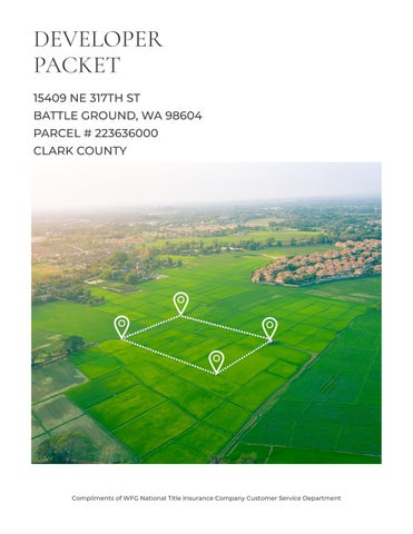
DEVELOPER PACKET

15409 NE 317TH ST

BATTLE GROUND, WA 98604

PARCEL # 223636000

CLARK COUNTY

Compliments of WFG National Title Insurance Company Customer Service Department

TABLE OF

Property Details

Custom Maps

Zoning Information

Community Information

-Demographics

-Traffic Counts

CONTENT S The information contained is provided by WFG’s Customer Service Department to our customers, and while deemed reliable, is not guaranteed.

The information contained is provided by WFG’s Customer Service Department to our customers, and while deemed reliable, is not guaranteed.

PROPERTY  Property Information
 Assessors Tax Map
 Vesting Deed
 Exhibit A
 County GIS Details DETAILS

ClarkCountyPropertyProfileInformation

Parcel#:223636000

RefParcel#:

Owner:Esteb,GraydonJ

CoOwner:

Site:15409NE317thSt

BattleGroundWA98604-7858

Mail:POBox2858

BattleGroundWA98604

Zoning:R-5Rural-5(R-5)

SchoolDist:119BattleGround

Census:1022040102

LandUse:11Household,SingleFamilyUnits

Legal:#31SEC12T4NR2EWM4.39A

ASSESSMENT&TAXINFORMATION PROPERTYCHARACTERISTICS

MarketTotal:$256,512.00

MarketLand:$239,764.00

MarketImpr:$16,748.00

AssessedTotal:$256,512.00

Exemption:

Taxes:$2,245.12

LevyCode:119018

LevyRate:84567

SALE&LOANINFORMATION

SaleDate:12/14/2012

SaleAmount:$152,50000

Document#:4921967

DeedType:Deed

LoanAmount:$149,73700

Lender:UMPQUABK

LoanType:FHA

InterestType:

TitleCo:CHICAGOTITLEINSURANCE COMPAN

ParcelType:RESIDENTIALACREAGE

YearBuilt:1992

Bedrooms:3

Bathrooms:175

BuildingTotal: 1stFloor:1,296SqFt

2ndFloor:

AC:

BsmtFin/Unfin:/ LotSize:439Acres(191,228SqFt)

LotWidth/Depth:443/443

Garage:

HeatSource:FA

Fireplace:

ImprType:

Plat/Subdiv:

Map:418-E2

Waterfront:

Watershed:EastForkLewisRiver

Recreation:

Latitude:45851978

Longitude:-122512547

SentryDynamics,Inc anditscustomersmakenorepresentations,warrantiesorconditions,expressorimplied,astotheaccuracyor completenessofinformationcontainedinthisreport

IMPROVEMENT1

BldgDesc:MOBILEHOME

Bedrooms:3

Baths,Full:1

Baths,3/4:1

Stories:1

1stFloor:1,296SqFt

2ndFloor:

YearBuilt:1992(1992)

ParcelID:223636000

Description:RANCH

Condition:AVERAGE

Use:MOBILEHOME

Quality:

Baths,1/2: BsmtFin: RoofingMatl:CMP

Baths,1/4:

Deck:

BsmtUnfin:

BldgFinTotal:1,296SqFt

Garage:

Carport:

ExtWall:VINYL AC: #Fireplaces:1

HeatType:FA

%Complete:100.00%

ParcelID:223636000

SiteAddress:15409NE317thSt

SentryDynamics,Inc anditscustomersmakenorepresentations, warrantiesorconditions,expressorimplied,astotheaccuracyor completenessofinformationcontainedinthisreport

AssessorMap

ParcelID:223636000

SentryDynamics,Inc anditscustomersmakenorepresentations, warrantiesorconditions,expressorimplied,astotheaccuracyor completenessofinformationcontainedinthisreport

AerialMap
Exhibit
The real property described above is commonly known as: [__________] [__________] __________ [__________] [__________] __________ Buyer Initials Date Seller Initials Date 15409 NE 317th Street Battle Ground, WA 98604
“A”

PROPERTY INFORMATION CENTER Account Summary

Property Identification Number: 223636000 MapsOnline Fact Sheet

Property Type: Real

Status: Active

Address: 15409 NE 317TH ST, BATTLE GROUND, WA 98604 (Situs Addresses)

Description: #31 SEC 12 T4N R2EWM 4.39A

Status: Regular Info for Senior/Disabled Property Tax Exemption

Property Owner ESTEB GRAYDON J

Owner
Address
Google Maps Street View Administrative Data Info... Jurisdiction Clark County Land Use Planning Comprehensive Plan Designation R-5 Comprehensive Plan Overlay(s) none Urban Growth Area County Zoning DesignationCodes Rural-5 (R-5) Zoning Overlay(s) none Miscellaneous Census Tract 401.02 Drainage District n/a Neighborhood East Fork Alliance Park District n/a Public Safety Burning Allowed Yes EMS Response Area North Country EMS Fire District Clark-Cowlitz Fire Rescue Increased Wildfire Danger Area Yes Police Jurisdiction CCSO Central Schools School District Name Battle Ground Elementary School Yacolt Electoral Data Board of County Councilors District 5 Camas Council Ward n/a CPU Commissioner District 1 Election Precinct 540 Legislative District 20 Library District Fort Vancouver Regional Library Port District No Port District School District Board Director District Director District 1 Sewer Board District n/a State Weed Board District 4 Land Data Approximate Area Info... 191,228 sq. ft. 4.39 acres Clark County Road Atlas Page 46 DOR Land Use Code Info... 11 Section-Township-Range NW 1/4,S12,T4N,R2E PDF Subdivision no data Survey 007075 Sales History Date of Sale 12/13/2012 Document Type D-SWD Document Number Excise Number 686721 Sale Amount $152,500.00 Date of Sale 12/10/2004 Assessment Data Info... 2023 Values for 2024 Taxes Market Value as of January 1, 2023 Land Value $279,483.00 Building Value $18,209.00 Total Property $297,692.00 Taxable Value Info... Total $297,692.00 2022 Values for 2023 Taxes Market Value as of January 1, 2022 Land Value $239,764.00 Building Value $16,748.00 Total Property $256,512.00 Taxable Value Info Total $256,512.00 General Assessor Neighborhood 6 Re-valuation Cycle 4 Notice of Value 2023 2022 2021 2020 2019 2018 2017
assessment value is valid as of the date printed on the linked notice of value. The notice of value will not reflect any updates to property value that occurred after the notice mail date Please contact the Assessor's office
Property
Site
Abbreviated
Tax
Mailing Address PO BOX 2858 BATTLE GROUND WA , 98604 Property Site
15409 NE 317TH ST, BATTLE GROUND, WA 98604
Property

if you have a question about your assessed value

The water service provider may be different from the indicated water district. Please contact the parcel's jurisdiction if you need to know the water service provider

If you have questions concerning the data on this page, please contact the Clark County Assessor’s Office. Main Phone: (564) 397-2391, Email: assessor@clark.wa.gov

Attendance Area Middle School Attendance Area Amboy High School Attendance Area Battle Ground Transportation C-TRAN Public Transportation Benefit Area No Traffic Impact Fee (TIF) District Rural Transportation Analysis Zone 597 Utilities CPU Lighting Utility District n/a Last Street Sweeping n/a Sewer District Rural/Resource Waste Collection Provider n/a Waste Collection Day No Data Water District Clark Public Utilities Document Type DEED Document Number Excise Number 556046 Sale Amount $104,850.00 Date of Sale 12/10/2004 Document Type DEED Document Number 0018209M Excise Number 999999999 Sale Amount $45,600.00 Date of Sale 03/15/1993 Document Type CONT Document Number Excise Number 348856 Sale Amount $90,000.00 Date of Sale 10/29/1992 Document Type D-CORR Document Number Excise Number 344251 Sale Amount $0.00

PROPERTY INFORMATION CENTER

Land & Building Details

Property Identification Number: 223636000 MapsOnline Fact Sheet

Property Type: Real

Property Status: Active

Site Address: 15409 NE 317TH ST, BATTLE GROUND, WA 98604 (Situs Addresses)

Abbreviated Description: #31 SEC 12 T4N R2EWM 4.39A

Tax Status: Regular

Info for Senior/Disabled Property Tax Exemption

If you have questions concerning the data on this page, please contact the Clark County Assessor’s Office. Main Phone: (564) 397-2391, Email: assessor@clark.wa.gov

Property Photo Photo Date: 03/06/2012 Click photo for
image Building Sketch No Image Available. Scanned Building Card Building 1 Summary Information Building Style RANCH Number of Bedrooms 3 Number of Bedrooms Approved for Septic System 3 FULL BATH 1 3/4 BATH 1 HEAT TYPE FA Fireplace WD-STV 1.00 Details 1 MOBILE HOME 1296 sq. ft. Effective Year Built 1992 Actual Year Built 1992 Building Type MOBILE HOME Construction Quality FAIR Condition AVERAGE
Photos & Imagery
printable

PROPERTY INFORMATION CENTER

Environmental Constraints

Property Identification Number: 223636000 MapsOnline Fact Sheet

Property Type: Real

Property Status: Active

Site Address: 15409 NE 317TH ST, BATTLE GROUND, WA 98604 (Situs Addresses)

Abbreviated Description: #31 SEC 12 T4N R2EWM 4.39A

Tax Status: Regular

Info for Senior/Disabled Property Tax Exemption

Cultural Resources

Archaeological Probability: Low-Moderate Moderate

Archaeological Site Buffer: No

Historic Site: No Mapping Indicators

Forest Practice Moratorium Info...

none

Geological Hazards Info...

Geological Hazard: Areas of Potential Instability Slopes > 15%

Liquefaction: Very Low Bedrock

NEHRP Class: B C

Slope Stability:

Habitat and Species Resources Info...

Habitat and Species Impacts: No Mapping Indicators

Wetlands and Soil Types

Critical Aquifer Recharge Area: Category 2 Recharge Areas

FEMA Map / FIRM Panel: Info...

53011C0250D

FEMA Flood Map Service Center

Flood Hazard Area: Info... Outside Flood Area

Shoreline

Designation: none

Soil Types / Class: Hydric / MnA Hydric / MnD

Non-Hydric / CrE

Water Resource Inventory Area: Name: LEWIS

Sub-Basin: East Fork Lewis

Watershed: East Fork Lewis River

Sub Watershed: Rock Creek (North)

Wetland Class: No Mapping Indicators

Wetland Inventory: Info... No Mapping Indicators

Septic Document Details

Application Date November 26, 2012

As-Built: Last Inspected November 26, 2012

Permit: onlineRME Docs (external site) November 23, 2012 November 26, 2012

Water Well Details

none

If you have any questions concerning the data on this page, please contact the land use department in your jurisdiction. For properties not within a city limits, contact Clark County Community Development. Main Phone: (564) 397-2375, Email: commdev@clark.wa.gov

PROPERTY INFORMATION CENTER

If you have any questions concerning the data on this page, please contact Clark County Treasurer's Office. Main Phone: (564) 397-2252, Email: treasoff@clark.wa.gov

Property Owner ESTEB GRAYDON J Other Payment Options 09/19/2023
Tax Summary
Property
Site Address:
Addresses) Abbreviated Description: #31 SEC 12 T4N R2EWM 4.39A Tax Status: Regular Info for Senior/Disabled Property Tax Exemption Owner Mailing Address PO BOX 2858 BATTLE GROUND WA, 98604 Property Location Address 15409 NE 317TH ST, BATTLE GROUND, WA 98604 Google Maps Street View Bing Maps Birds Eye 2023 Tax Information  Pay Online Payment service fees: Free E-Check, 2.39% Credit Card, $3.95 Debit Card Tax Code Area: 119018 Millage Rate: 8.4566555548 Tax and Assessment Distribution Tax Statements Tax Bill Summary Taxable Value $256,512.00 Tax Amount $2,245.12 Tax Paid $1,122.63 1st Half Billed - Does not reflect payments Amount Billed $1,122.63 Payment Due Date Apr. 30, 2023 2nd Half Billed - Does not reflect payments Amount Billed $1,122.49 Payment Due Date Oct. 31, 2023 Tax Years Owing *Interest & Penalty calculates on delinquent taxes Tax Year Statement ID Amount Billed Calc Date* Interest Penalty Total Due 2023 140621 $1,122.49 $0.00 $0.00 $1,122.49 Tax History Tax Year Statement ID Billed Paid Interest Paid Penalty Paid 2023 140621 $2,245.12 $1,122.63 $0.00 $0.00 2022 140751 $1,939.99 $1,939.99 $0.00 $0.00 2021 140915 $2,045.49 $2,045.49 $0.00 $0.00 2020 141085 $2,063.94 $2,063.94 $0.00 $0.00 2019 141308 $1,649.40 $1,649.40 $0.00 $0.00 2018 141470 $2,175.46 $2,175.46 $0.00 $0.00 2017 141609 $1,660.00 $1,660.00 $0.00 $0.00 2016 141711 $1,789.56 $1,789.56 $0.00 $0.00 2015 142064 $1,767.31 $1,767.31 $0.00 $0.00 2014 142209 $1,864.96 $1,864.96 $0.00 $0.00 2013 142317 $1,930.52 $1,930.52 $0.00 $0.00 2012 142452 $2,071.59 $2,071.59 $0.00 $0.00 2011 142569 $2,003.36 $2,003.36 $0.00 $0.00 2010 142682 $1,902.46 $1,902.46 $0.00 $0.00 2009 142906 $1,989.50 $1,989.50 $0.00 $0.00 2008 464879 $1,858.72 $1,858.72 $0.00 $0.00 2007 302340 $1,362.03 $1,362.03 $0.00 $0.00 2006 143587 $1,478.15 $1,478.15 $0.00 $0.00
Property Identification Number: 223636000 MapsOnline Fact Sheet Property Type: Real
Status: Active
15409 NE 317TH ST, BATTLE GROUND, WA 98604 (Situs

CUSTOM

 Aerial

 Transportation

 Environmental Public Health

 Slopes & Geologic Hazards

 Soils, Wetlands & Natural Resources

 Surveys

 Utilities (Water & Sewer lines)

The information contained is provided by WFG’s Customer Service Department to our customers, and while deemed reliable, is not guaranteed.
MAPS

Aerial

2,257 1:

Legend Notes:

Taxlots

This map was generated by Clark County's "MapsOnline" website. Clark County does not warrant the accuracy, reliability or timeliness of any information on this map, and shall not be held liable for losses caused by using this information. Taxlot (i.e., parcel) boundaries cannot be used to determine the location of property lines on the ground.

Clark County, WA. GIS - http://gis.clark.wa.gov 376.2
376.2 0 188.08
WGS_1984_Web_Mercator_Auxiliary_Sphere Feet

18,056 1:

Legend Notes:

C-Tran Bus Stop

C-Tran Facilities

C-Tran Transit Center

C-Tran Park and Ride

C-TRAN Routes

Road Route Systems

State Route

Battle Ground Route

LaCenter Route

Other Municipal Route

Vancouver Route County Route

Proposed Route

Concurrency Route

Bike Routes

Bike Lanes or wide shoulders, usually on higher

Shared Roadway, on lower traffic street

Shared Roadway, with wider outside Lane on higher traffic street

Difficult Connection

Shared Roadway/Difficult Connection, lower traffic sight limitations and higher speeds

Paved Multi-use Paths, closed to motor vehicles

Unpaved Multi-use Paths, closed to motor vehicles

Cyclists Prohibited

Planned Bikeways

Main Track

All Roads

Interstate State Route Arterial

Forest Arterial

Minor Collector

Forest Collector

Private or Other Taxlots

This map was generated by Clark County's "MapsOnline" website. Clark County does not warrant the accuracy, reliability or timeliness of any information on this map, and shall not be held liable for losses caused by using this information. Taxlot (i.e., parcel) boundaries cannot be used to determine the location of property lines on the ground.

County, WA. GIS
http://gis.clark.wa.gov 3,009.3
Feet 3,009.3 0 1,504.67
Transportation Clark
-
WGS_1984_Web_Mercator_Auxiliary_Sphere

4,514 1:

Legend Notes:

Clark County, WA. GIS - http://gis.clark.wa.gov 752.3 WGS_1984_Web_Mercator_Auxiliary_Sphere Feet 752.3 0 376.17
Environmental Public Health
This map was generated by Clark County's "MapsOnline" website. Clark County does not warrant the accuracy, reliability or timeliness of any information on this map, and shall not be held liable for losses caused by using this information. Taxlot (i.e., parcel) boundaries cannot be used to determine the location of property lines on the ground. Septic System No Associated Documents Apps. and As-Builts online RME Documents Both Available Landfills Building Footprints Taxlots

Slopes & Geological Hazards

2,257 1:

Legend

Taxlots

Percent Slope

0-5 percent

>5-10 percent

>10-15 percent

>15-25 percent

>25-40 percent

>40-80 percent

>80 percent

Severe Erosion Hazard Areas

Steep Slopes and Landslide Hazard Areas

Areas of Historic or Active Landslides

Areas of Potential Instability

Areas of Older Landslide Debris

Slopes > 15%

Slopes > 25%

Notes:

This map was generated by Clark County's "MapsOnline" website. Clark County does not warrant the accuracy, reliability or timeliness of any information on this map, and shall not be held liable for losses caused by using this information. Taxlot (i.e., parcel) boundaries cannot be used to determine the location of property lines on the ground.

376.2
Feet 376.2 0 188.08
Clark County, WA. GIS - http://gis.clark.wa.gov
WGS_1984_Web_Mercator_Auxiliary_Sphere

Soils, Wetlands & Natural Resources

2,257 1:

Legend

Taxlots

FIRM Panels

Base Flood Elevation

Flood Zone Designation Floodway

Floodway Fringe 500 Year Flood Area Area Not Studied

Soil Type

Permitted Wetland

NWI Wetland

Modeled Wetland

Depth

Watershed

Sub-Watershed

Notes:

This map was generated by Clark County's "MapsOnline" website. Clark County does not warrant the accuracy, reliability or timeliness of any information on this map, and shall not be held liable for losses caused by using this information. Taxlot (i.e., parcel) boundaries cannot be used to determine the location of property lines on the ground.

376.2
Feet 376.2 0 188.08
Clark County, WA. GIS - http://gis.clark.wa.gov
WGS_1984_Web_Mercator_Auxiliary_Sphere
to Water 10 ft 20 ft 30 ft

Surveys

4,514 1:

Legend Notes:

Survey - Recorded

Survey - Unrecorded

Survey - Performed by County Building Footprints

Taxlots

This map was generated by Clark County's "MapsOnline" website. Clark County does not warrant the accuracy, reliability or timeliness of any information on this map, and shall not be held liable for losses caused by using this information. Taxlot (i.e., parcel) boundaries cannot be used to determine the location of property lines on the ground.

Clark County, WA. GIS - http://gis.clark.wa.gov 752.3
752.3 0 376.17
WGS_1984_Web_Mercator_Auxiliary_Sphere Feet

752.3

WGS_1984_Web_Mercator_Auxiliary_Sphere

Clark County, WA. GIS - http://gis.clark.wa.gov

0 376.17

4,514 1:

Legend Notes:

Sanitary Sewer Water Line

Building Footprints

Taxlots

Feet 752.3

This map was generated by Clark County's "MapsOnline" website. Clark County does not warrant the accuracy, reliability or timeliness of any information on this map, and shall not be held liable for losses caused by using this information. Taxlot (i.e., parcel) boundaries cannot be used to determine the location of property lines on the ground.

Utilities

R-5 (Rural-5)

ZONING

The information contained is provided by WFG’s Customer Service Department to our customers, and while deemed reliable, is not guaranteed.

 Zoning Map  Detailed Zoning Information
DETAILS

WGS_1984_Web_Mercator_Auxiliary_Sphere

Zoning

Feet

Legend Notes:

Zoning - Outline

Zoning - Outline_labels

Zoning

Single-Family residential (R1-20, R-20)

Single-Family residential (R1-15, R-15)

Single-Family residential - 12 (R-12)

Single-Family residential (R1-10, R-10, R10)

Single-Family residential (R1-7.5, R-7.5, LDR-7.5)

Single-Family residential (R1-6, R-6, LDR-6)

Single-Family residential (R1-5)

Residential (R-12, R12)

Residential (R-18, MF-18)

Residential (R-22, AR-22)

Residential (R-30)

Residential (R-43)

Office residential-15 (OR-15)

Office residential-18 (OR-18)

Office residential-22 (OR-22)

Office residential-30 (OR-30)

Office residential-43 (OR-43)

Neighborhood commercial (NC, C1, CN, CNB)

Community commercial (CC, C2, CCB)

General commercial (GC, CG)

Mixed use (MX)

Business park (BP, OFF)

Light industrial (IL, ML, LI, IND, LI/EC, WE)

Heavy industrial (IH, MH, HI) University (U)

Airport (A)

Public facilities (PF, IP, UP)

Rural-5 (R-5)

Rural-10 (R-10)

Rural-20 (R-20)

Rural center residential 1 ac min (RC-1)

Rural center residential 2.5 ac min (RC-2.5)

Rural comm.-inside rur.centers (CR-2)

Rural comm.-outside rur.center (CR-1)

Agriculture-20 (AG-20)

Agriculture/Wildlife (AG/WL)

Parks/Open Space (P/OS)

Parks/Wildlife refuge (P/WL)

Forest tier II-40 (FR-40)

4,514 1:

Forest-80 (FR-80)

Water

Low density residential-2 du/ac (R-2)

Residential 3 units/acre (R3)

Single-family residential (R1-12.5)

This map was generated by Clark County's "MapsOnline" website. Clark County does not warrant the accuracy, reliability or timeliness of any information on this map, and shall not be held liable for losses caused by using this information. Taxlot (i.e., parcel) boundaries cannot be used to determine the location of property lines on the ground.

Low density residential-4 du/ac (R-4, RLD-4)

Clark County, WA. GIS - http://gis.clark.wa.gov 752.3
752.3 0 376.17

40.210.020 Rural Districts (R-20, R-10, R-5)

A. Purpose.

The rural districts are intended to provide lands for residential living in the rural area. Natural resource activities such as farming and forestry are allowed and encouraged in conjunction with the residential uses in the area. These areas are subject to normal and accepted forestry and farming practices.

(Amended:Ord 2018-01-09;Ord 2019-03-05;Ord 2019-07-01;Ord 2020-03-08)

B. Uses.

The uses set out in Table 40.210.020-1 are examples of uses allowable in the various rural zone districts. The appropriate review authority is mandatory.

•  “P” – Uses allowed subject to approval of applicable permits.

•  “R/A” – Uses permitted upon review and approval as set forth in Section 40 520 020

•  “C” – Conditional uses which may be permitted subject to the approval of a conditional use permit as set forth in Section 40.520.030.

•  “X” – Uses specically prohibited.

Where there are special use standards or restrictions for a listed use, the applicable code section(s) in Chapter 40.260, Special Uses and Standards, or other applicable chapter is noted in the “Special Standards” column.

R-20 R-10 R-5 Special Standards 1. Residential. a Single-family dwellings and accessory buildings, including one (1) guest house P P P 40 260 010 b. Rural accessory dwelling unit P P P 40.260.022 c. Family day care centers P P P 40.260.160 d. Adult family homes P P P 40.260.190 e. Home business – Type I P P P 40 260 100 f Home business – Type II R/A R/A R/A 40 260 100 g. Bed and breakfast establishments (up to two (2) guest bedrooms) R/A R/A R/A 40.260.050 h. Bed and breakfast establishments (three (3) or more guest bedrooms) C C C 40 260 050 i. Country inns of historic signicance C C C j Garage sales P P P 40 260 090 k. Residential care homes C C C 40.260.180 l. Temporary dwellings P P P 40.260.210 m. Staed residential homes C C C 40.260.205
Table 40.210.020-1. Uses
40 210 020-1 Uses R-20 R-10 R-5 Special Standards
Services, Business.
Commercial nurseries
landscaping materials R/A R/A R/A b Roadside farm stand P P P 40 260 025 c Agricultural market P P P 40 260 025 d. Veterinary clinics C C C e. Commercial kennels on a parcel or parcels ve (5) acres or more R/A R/A R/A 40 260 110 f. Private kennels P P P 40.260.110 g Animal boarding and day use facilities P P P 40 260 040 3. Services, Amusement. a. Publicly owned recreational facilities, services, parks and playgrounds4 P P P 40 260 157 b. Private recreation facilities, such as country clubs and golf courses,
intensive commercial recreational uses as golf driving range, race track, amusement park, paintball facilities, or gun club C C C c Golf courses C C C d. Equestrian facility on parcels less than ve (5) acres C C C 40.260.040 e. Equestrian facility on parcels ve (5) acres or greater P P P 40 260 040 f. Equestrian events center C C C 40.260.040 g Outdoor public entertainments, amusements and assemblies R/A R/A R/A Chapter 5.32 h. Tasting room and event facilities in conjunction with a winery P P P 40.260.245 4. Services, Membership Organization. a. Churches C C C 5. Services, Educational. a Public or private schools, but not including business, dancing or technical schools C C C 40 260 160 6. Public Service and Facilities.4 a Ambulance dispatch facilities4 C C C 40.260.030 b. Government facilities4 C1 C1 C1 7. Resource Activities. a. Agricultural and forestry, including any accessory buildings and activities P P P 40.260.080
Table
2.
a.
predominantly marketing locally produced plants and associated
including such

uses including but not limited to utility substations, pump

columbaria, and mortuaries within cemeteries; provided, that no crematoria is within two hundred (200) feet of a lot in a residential district

1 Governmentfacilitiesnecessarytoservetheareaoutsideurbangrowthboundaries, includingrestations, ambulancedispatchfacilitiesandstorageyards, warehouses, or similaruses

2 Commercialusessupportingagriculturalandforestryresourceuses, suchaspacking, rststageprocessingandprocessingwhichprovidesvalueaddedtoresourceproducts

3 SeeTable40.260.250-1.

4 Onceapropertyhasbeendevelopedasapublicfacility, adocketisrequiredtochange thecomprehensiveplandesignationfromthecurrentzonetothePublicFacilitieszone. (Amended:

R-20 R-10 R-5 Special Standards b. Silviculture P P P 40.260.080 c. Commercial
agricultural and forestry resource uses P2 P2 P2 d Housing for temporary workers P P P 40 260 105 8 Other a. Private use landing
for aircraft and heliports C C C 40.260.170 b. Solid waste handling and disposal sites C C C 40 260 200
Utilities,
and
stations, wells, watershed intake facilities, gas and water transmission lines P P P 40.260.240 d Wireless communications facilities P/C3 P/C3 P/C3 40 260 250 e. Cemeteries and mausoleums,
C C C f. Temporary uses P P P 40.260.220 g Electric vehicle infrastructure P P P 40 260 075 h Medical marijuana cooperative X X X 40 260 115 i. Marijuana production facilities X X X 40.260.115 j. Marijuana processor 1 facilities X X X 40.260.115 k. Marijuana processor 2 facilities X X X 40.260.115 l Marijuana retailer facilities X X X 40 260 115
Table 40 210 020-1 Uses
uses supporting
strips
c.
structures
crematoria,
Ord. 2003-12-15; Ord. 2005-04-12; Ord. 2007-06-05; Ord. 2010-08-06; Ord. 2010-10-02; Ord. 2011-03-09; Ord. 2011-06-14; Ord. 2011-08-08; Ord. 2011-12-09; Ord. 2012-02-03; Ord. 2012-02-08; Ord. 2012-06-02; Ord. 2012-12-23; Ord. 2013-07-08; Ord.

2014-05-07; Ord 2014-11-02; Ord 2016-06-12; Ord 2018-01-09; Ord 2019-03-05; Ord 2019-07-01;Ord 2020-03-08)

C. Development Standards.

1. Unless otherwise permitted under Section 40.210.020(D) (Rural Cluster Development), new lots and structures and additions to structures subject to this section shall comply with the applicable standards for lots and building height, and setbacks in Tables 40.210.020-2 and 40.210.020-3, subject to the provisions of Chapter 40.200 and Section 40.550.020.

one

1 Utilities, structuresandusesincludingbutnotlimitedtoutilitysubstations, pump stations, wells, watershedintakefacilities, gasandwatertransmissionlinesand telecommunicationfacilitiesmaybepermittedonnewlyapprovedlotsoflessthanthe minimumparcelsize.

2 UnlessagreaterwidthshallberequiredbytheClarkCountyrecode.

1 SideSetback. Minimumsidesetbackoneachsideoftheresidentialdwellingand incidentalbuildingsshallbetwenty(20)feetunlessreregulationsrequireagreater setback, andfty(50)feetforaccessorybuildingsusedforagriculturalpurposes. Side setbacksfromabuttingpropertyzonedagriculturalorforestryshallbeaminimumoffty (50)feetforallstructures. Sidesetbacksfromabuttingpropertyzonedforsurfacemining usesshallbeonehundredfty(150)feet,unlessalessersetbackisapprovedperSection 40.250.022(D)(2)(b).

2 RearSetback. Minimumrearsetbackforallstructureswhentheabuttingpropertyisnot zonedfornaturalresourceorsurfaceminingusesistwenty(20)feetunlessre regulationsrequireagreatersetback. Minimumrearsetbackforallstructuresshallbefty

Zoning District Minimum Lot Area (acres)1 Minimum Lot Width (feet) Minimum Lot Depth (feet) R-20 20 acres or legally
thirty-second
330 None R-10 10 acres or legally
330 None R-5 5 acres
1402 None
Table 40.210.020-2. Lot Requirements
described as one
(1/32) of a section
described as one sixtyfourth (1/64) of a section
or legally described as one
hundred and twenty-eighth (1/128) of a section
Zoning District Minimum Setbacks4 Maximum Lot Coverage Maximum Building Height (feet) Front (feet) Side Rear (feet)2 Street (feet) Interior (feet)1 R-20 505 25 20, 50 20, 50 N/A 353 R-10 505 25 20, 50 20, 50 N/A 353 R-5 505 25 20, 50 20, 50 N/A 353
Table 40.210.020-3. Setbacks, Lot Coverage and Building Height

(50)feetwhenabuttingpropertyiszonedfornaturalresourceuses Rearsetbacksfrom abuttingpropertyzonedforsurfaceminingusesshallbeaminimumofonehundredfty (150)feetforallstructures, unlessalessersetbackisapprovedperSection40250022(D) (2)(b)

3 Residentialbuildingsonly

4 NonconforminglotssubjecttotheprovisionsofSection40530010(D)(2)

5Frompublicroadright-of-way, privateroadeasementortract,orprivatedriveway easementthatprovidesaccesstothelot.

(Amended:Ord. 2005-04-12;Ord. 2010-08-06;Ord. 2012-07-03;Ord. 2016-09-04)

2. Previous Land Divisions. Until the aected property is included within an urban growth boundary, no remainder lot of a previously approved cluster land division or lot reconguration may be:

a. Further subdivided or reduced in size below seventy percent (70%) of the total developable area of the original parent parcel constituting the cluster subdivision; or

b Reduced by a total of more than one (1) acre.

c. Applications for reduction in remainder lot size consistent with this provision shall be processed as a plat alteration pursuant to Section 40.540.120.

d. Exceptions to Sections 40.210.020(C)(2)(a) and (b) may be allowed as follows:

(1) A remainder lot with an existing residence may be short platted further to contain the residence on its own cluster lot, subject to the following:

(a) Process Creation of the new cluster lot is subject to the requirements of Section 40 540 030;

(b) Lot Size. The new cluster lot shall not be greater than one (1) acre in size, unless a greater size is required by Clark County Public Health;

(c) The new cluster lot must meet the requirements of Section 40.210.020(D)(3)(b) and the lot dimension and setback requirements of Tables 40.210.020-4 and 40.210.020-5;

(d) The reduced remainder shall not be further divided and shall be subject to the requirements in Sections 40.210.020(D)(3)(c)(2)(a)(i) and (ii).

(2) A remainder lot created through a cluster subdivision or cluster short plat authorized under Section 18.301.090, Agricultural District, or Section 18.302.090, Forest District, may be further divided if each of the following requirements is satised:

(a) The property has been rezoned from Agricultural or Forest, twenty (20) acre minimum lot size to a nonresource zone;

(b) There exists no plat note restricting redivision before the property is brought into the urban growth area;

(c) There is compliance with the plat alteration provisions (RCW 58 17 215) related to the plat/short plat creating the remainder, if applicable; and

(d) The division of the remainder lot meets the requirement of Chapter 58.17 RCW.

3. Signs. Signs shall be permitted according to the provisions of Chapter 40.310.

4. O-Street Parking. O-street parking shall be provided as required in Chapter 40.340.

(Amended:Ord 2011-08-08;Ord 2014-01-08;Ord 2018-01-09)

D. Rural Cluster Development.

1. Purpose. The purpose of this section is to provide for small lot residential development in the rural zoning districts (R-5, R-10 and R-20) which maintains rural character, maintains and conserves larger remainder parcels, protects and/or enhances sensitive environmental and wildlife habitat areas, and minimizes impacts to necessary public services. These goals are achieved by allowing the placement of homes on a small portion of the property while maintaining the majority of the site in a remainder parcel. This is consistent with the goals and policies of the Growth Management Act, especially the provisions for innovative development techniques to conserve open space and resource lands.

2. Denitions. For the purposes of this section, the following denitions shall apply:

a “Building envelope” shall mean that buildable portion of a lot or parcel (the area outside of setbacks and easements) which is designated on the nal plat for the location of a structure.

b “Critical lands,” for the purposes of this section, shall mean those lands classied by Chapter 40 440 as habitat areas, by Chapter 40 450 as any wetland category and associated buers, by Chapter 40 430 as landslide hazard areas, all lands subject to Shoreline Management Act jurisdiction by Chapter 40 460, and all lands within a designated one hundred (100) year oodplain or oodway by Chapter 40 420

c. “Remainder parcel” shall mean the remainder parcel of the cluster provision that contains the majority of the land within the development and is devoted to open space, resource or other authorized use.

3. Development Standards.

a. Maximum Density. Cluster developments are allowed a maximum density equivalent to that which would be permitted by applying the otherwise applicable minimum lot size requirements of this section. The density shall be based on one hundred ten percent (110%) of the gross area of the site.

b Cluster Lots

(1) Cluster lots shall be sited to minimize conicts between housing and adjacent agricultural or forest zoned property.

(2) Cluster lots and building envelopes may not include critical areas unless no other alternative exists If no alternative is available, encroachment into these areas shall be limited to the least amount possible consistent with applicable critical areas ordinances

c. Remainder Parcel.

(1) The remainder parcel shall be contiguous. Fragmentation of the parcel by public or private road easements and/or building sites shall not occur unless no other reasonable alternative exists. The remainder parcel shall provide a buer for the cluster lots from adjacent lands in a resource zoning district. Remainder parcels shall also be located adjacent to other bordering remainder parcels or public parks and open space. To the maximum extent possible, all critical areas and any associated buers existing on property proposed for cluster development shall be located within the remainder parcel. In order to retain the rural character the remainder parcel should contain to the maximum extent possible forested areas, prominent hillsides, meadows and ridges.

(2) There are two (2) ways of utilizing the maximum density allowed within a cluster development, as follows:

(a) The creation of cluster lots equal to no more than the maximum allowed density, with a remainder parcel that can be used only for the agriculture and forestry uses as listed in Table 40 210 020-1(7)(a), (b) and (d) or as open space. An example of this would be a twenty (20) acre parcel in the R-5 district, where four (4) cluster lots and one (1) remainder are created All of the allowed density is used on the cluster lots, and the remainder parcel can only be used as open space or for agriculture or forestry uses.

(i) If this option is used, an open space, equestrian, farm or forest management plan is required for the remainder parcel The plan shall be submitted and approved with the preliminary application The plan shall identify permitted uses and management of the parcel so that it maintains its open space or other designated functions and provides for the protection of all critical areas The management plan shall identify the responsibility for maintaining the remainder parcel The plan shall also include any construction activities (trails, fencing, agricultural buildings) and vegetation clearing that may occur on site. The plan shall include building envelopes for any proposed equestrian facility This building envelope must be located outside of any critical areas including sh and wildlife habitat areas, riparian corridors, geologic hazard areas, areas of signicant natural vegetation, wetlands, prominent hillsides, meadows, ridges and any buers associated with the above areas All subsequent activities must be conducted in conformance with the approved management plan Management plans may be modied through a Type II process

(ii) A note shall be placed on the plat and a restrictive covenant shall be recorded that clearly states that only the above uses are

permitted on the parcel The note and covenant shall also incorporate the management plan, as described above.

(b) The creation of cluster lots equal to no more than one (1) less than the maximum allowed density with a remainder parcel that can also be developed. If this option is used, the remainder parcel may contain the uses listed in Table 40.210.020-1. An example of this would be a twenty (20) acre parcel in the R-5 district, where three (3) cluster lots and one (1) remainder are created. The allowed density, less one (1), is used on the cluster lots. This permits the remainder parcel to be developed with any of the uses normally allowed in the rural districts. If the remainder parcel is to be residentially developed, a building envelope shall be delineated on the nal plat. This building envelope must be located outside of any critical areas including sh and wildlife habitat areas, riparian corridors, geologic hazard areas, areas of signicant natural vegetation, wetlands, prominent hillsides, meadows, ridges and any buers associated with the above areas. This requirement shall not apply to pre-existing residences located on the remainder lot.

4. Lot Requirements. New lots and structures and additions to structures subject to this section shall comply with the applicable standards for lots and building height, and setbacks in Tables 40.210.020-4 and 40.210.020-5, subject to the provisions of Chapter 40.200 and the Section 40.550.020.

1 UnlessalargersizeisrequiredbytheClarkCountyHealthDepartment.Clusterlotscan useright-of-waytomeettheminimumlotsizeaspermittedbySection40.200.040(C)(1).

2 Theminimumstandardforremainderparcelscontrolsthemaximumsizeofclusterlots

3 UnlessagreaterwidthshallberequiredbytheClarkCountyrecode.

Lot Type Zoning District Minimum Lot Area Maximum Lot Size Minimum Lot Width (feet) Minimum Lot Depth (feet) Cluster Lot R-20, R-10, R-5 1 acre1 None2 1003 140 Remainder Lot R-5 65% of site None2 None None R-20, R-10 75% of site None2 None None
Table 40.210.020-4. Lot Requirements – Rural Cluster Development
Zoning District and Lot Type Location or Structure Type Minimum Setbacks Maximum Lot Coverage Maximum Building Height (feet) Front (feet) Side (feet) Rear (feet)
Table 40.210.020-5. Setbacks, Lot Coverage and Building Height – Rural Cluster Development

Table 40 210 020-5 Setbacks, Lot Coverage and Building Height – Rural Cluster Development

1 Exceptincaseswhereitcanbeshownthatalessersetbackwillprovidethesameor greaterbueringorwhererequiringthenormalsetbackwillresultinthelocationofthe buildingsiteswithininappropriateareassuchaswildlifehabitatorwetlandareasorthe dimensionsofthedevelopmentsiterenderitunbuildable.

2 Residentialbuildingsonly.

(Amended:Ord. 2007-06-05)

5. Design Requirements. The design requirements for cluster developments are listed below. These requirements shall be recorded on the plat.

a. No entryway treatments, monument or other permanent development signs are permitted. This shall not be construed to prohibit landscaping.

b. Sight-obscuring fences of any height are not permitted within fty (50) feet of the public right-of-way, nor along cluster lot lines adjacent to the remainder lot. Sight-obscuring fences are at least fty percent (50%) opaque.

c. To the maximum practicable extent, existing historic rural features shall be preserved as part of the cluster development. These features include but are not limited to rock walls, fences, functional and structurally safe farm buildings, monuments and landscape features.

6 Landscaping Standards Cluster developments shall be landscaped within the developed portion of cluster lots, so as to reduce views of the development from the public right(s)-of-way so that a ltered view is provided of the cluster and the cluster does not dominate the landscape.

a. At a minimum, proposed or existing landscaping and vegetation shall be of sucient size and type to provide a buer of vegetation six (6) feet in height and fty percent (50%) opaque year round within three (3) years of planting. New landscaping materials shall consist of native vegetation as identied by the Clark Conservation District. A combination of trees and shrubs must be used.

b. All landscaping shall be installed prior to nal plat unless nancial guarantees are made for its installation prior to any building permit activity. Any required landscaping materials that fail to survive within the rst two (2) years shall be promptly replaced.

7. Previously Approved Cluster and Lot Reconguration Remainder Lots. Previously approved cluster or lot reconguration remainder lots are not eligible to use the provisions of this section.

R-20,
and
–Cluster Lots and Remainder Lots Abutting a cluster lot 20 20 20 N/A 352 Abutting a resource district 2001 2001 2001 Agricultural structures 50 50 50 Vehicle entry gates or garage door openings 20 20 20 All other situations 50 20 50
R-10,
R-5

Procedures Cluster land divisions shall be processed in accordance with the established procedures for land divisions under Chapter 40 540

9. Notice of Resource Activities. Where otherwise undevelopable cluster remainder parcels are designated for commercial timber or agricultural activities the following notice shall be recorded as part of the Developer Covenants to Clark County for each parcel within the cluster:

The subject property is adjacent to commercial agricultural or forest lands on which a variety of commercial activities may occur that are not compatible with residential development. Potential discomforts or inconvenience may include, but are not limited to: Noise, odors, fumes, dust, smoke, insects, operation of machinery (including aircraft) during any twenty-four (24) hour period, storage and disposal of manure, and the application by spraying or otherwise of chemical fertilizers, soil amendments, herbicides and pesticides.

10. Additional Development Standards for Equestrian Cluster.

a Utilization of maximum density shall be consistent with the method described in Section 40 210 020(D)(3)(a)

b. An equestrian cluster is required to provide the following shared facilities on the site:

i. Covered riding arena to be located on the remainder lot within development envelopes not to exceed two (2) acres.

ii. Continuous internal trail(s) system with access to all equestrian facilities and lots. The trails shall connect with existing and future trails.

c. An equestrian plan that addresses the following shall be developed and implemented:

i Housing and connement;

ii. Animal husbandry;

iii. Manure management; and

iv. Odor and noise management.

d Landscaping Standards

i. The perimeter of the cluster lots and the equestrian facilities shall be screened from abutting properties per Section 40.210.020(D)(6)(a).

e. If shared boarding facilities are proposed they shall be located on the remainder lot within development envelopes not to exceed two (2) acres and shall accommodate a minimum number of horses equal to the number of cluster lots in the proposed development. The shared boarding facility shall include the following features:

i. Wash rack.

ii. Grooming stand.

8

f. The remainder lot in the nal development plan that includes shared equestrian facilities, including trails, structures and/or landscaping shall be permanently maintained by and conveyed to the following:

i. An association of owners shall be formed and continued for the purpose of maintaining the shared equestrian facilities. The association shall be created as an association of owners under the laws of the state and shall adopt and propose articles of incorporation or association and bylaws, and adopt and improve a declaration of covenants and restrictions on the shared equestrian facility that is acceptable to the prosecuting attorney, in providing for the continuing care of the facilities. No equestrian facilities may be put to a use not specied in the nal development plan unless the nal development plan is rst amended to permit the use. No change of use may be considered as a waiver of any covenants limiting the use of shared equestrian facilities, and all rights to enhance these covenants against any use permitted are expressly reserved.

g. A proposal with shared boarding facilities shall have cluster lots that are a minimum of one acre in size unless a larger size is required by the Clark County health department.

(Amended: Ord 2005-04-12; Ord 2005-06-09; Ord 2007-11-13; Ord 2012-12-20; Ord 2012-12-23;Ord 2014-01-08)

Compile Chapter

The Clark County Code is current through Ordinance 202305-11, passed May 16, 2023

Disclaimer: The Clerk of the Board's Oce has the ocial version of the Clark County Code. Users should contact the Clerk of the Board's Oce for ordinances passed subsequent to the ordinance cited above.

County Website: https://www clark wa gov/ (https://www clark wa gov/) County Telephone: (564) 397-2232 Code Publishing Company (https://www.codepublishing.com/)

iii Tack room

COMMUNITY

INFORMATION

Demographics

 Traffic Counts

The information contained is provided by WFG’s Customer Service Department to our customers, and while deemed reliable, is not guaranteed.

15409 NE 317th St, Battle Ground, WA 98604
15409 NE 317th St, Battle Ground, WA 98604 Sitewise Online Pop-Facts: Population Quick Facts Pop-Facts: Population Quick Facts 15409 NE 317th St, Battle Ground, WA 98604 0 - 1 mi Population 2027 Projection 981 2022 Estimate 918 2010 Census 785 2000 Census 692 Growth 2022-2027 6.85% Growth 2010-2022 16.99% Growth 2000-2010 13.46% 2022 Est. Population by Age 918 Age 0 to 4 53 5.72% Age 5 to 9 61 6.66% Age 10 to 14 60 6.58% Age 15 to 17 45 4.89% Age 18 to 20 41 4.49% Age 21 to 24 55 5.99% Age 25 to 34 134 14.55% Age 35 to 44 74 8.01% Age 45 to 54 93 10.13% Age 55 to 64 125 13.60% Age 65 to 74 113 12.29% Age 75 to 84 55 5.99% Age 85 and over 10 1.10% Age 16 and over 729 79.42% Age 18 and over 699 76.15% Age 21 and over 658 71.66% Age 65 and over 178 19.38% 2022 Est. Median Age 36.40 2022 Est. Average Age 39.61
2022 Est. Population by Single-Classification Race 918 White Alone 861 93.84% Black or African American Alone 3 0.30% American Indian and Alaska Native Alone 2 0.27% Asian Alone 6 0.68% Native Hawaiian and Other Pacific Islander Alone 0 0.02% Some Other Race Alone 17 1.83% Two or More Races 28 3.05% 2022 Est. Population by Ethnicity (Hispanic or Latino) 918 Hispanic or Latino 47 5.08% Not Hispanic or Latino 871 94.92% 2022 Est. Population by Sex 918 Male 463 50.49% Female 455 49.51% Copyright
15409 NE 317th St, Battle Ground, WA 98604 Sitewise Online Pop-Facts: Population Quick Facts Pop-Facts: Population Quick Facts 15409 NE 317th St, Battle Ground, WA 98604 0 - 1 mi
© Claritas, LLC 2022. All rights reserved.
15409 NE 317th St, Battle Ground, WA 98604 Sitewise Online Pop-Facts: Household Quick Facts Pop-Facts: Household Quick Facts 15409 NE 317th St, Battle Ground, WA 98604 0 - 1 mi Households 2027 Projection 316 2022 Estimate 294 2010 Census 247 2000 Census 205 Growth 2022-2027 7.37% Growth 2010-2022 19.24% Growth 2000-2010 20.00% 2022 Est. Households by Household Income 294 Income Less than $15,000 18 6.25% Income $15,000 to $24,999 8 2.72% Income $25,000 to $34,999 8 2.78% Income $35,000 to $49,999 22 7.63% Income $50,000 to $74,999 44 14.81% Income $75,000 to $99,999 44 14.93% Income $100,000 to $124,999 35 12.01% Income $125,000 to $149,999 31 10.63% Income $150,000 to $199,999 40 13.65% Income $200,000 to $249,999 25 8.37% Income $250,000 to $499,999 14 4.83% Income $500,000 or more 4 1.40% 2022 Est. Average Household Income $ 122,877 2022 Est. Median Household Income $ 101,843 2022 Median HH Inc. by Single-Classification Race White Alone $ 101,826 Black or African American Alone $ 196,619 American Indian and Alaska Native Alone $ 30,000 Asian Alone $ 64,063 Native Hawaiian and Other Pacific Islander Alone $ 42,500 Some Other Race Alone $ 43,532 Two or More Races $ 166,678 Hispanic or Latino $ 125,463 Not Hispanic or Latino $ 101,017 2022 Est. Households by Household Type 294 Family Households 251 85.50% Nonfamily Households 43 14.50%
2022 Est. Group Quarters Population 3 2022 Est. Households by Household Size 294 1-person 35 11.85% 2-person 124 42.03% 3-person 41 13.86% 4-person 40 13.65% 5-person 20 6.71% 6-person 14 4.79% 7-or-more-person 21 7.12% 2022 Est. Average Household Size 3.11 15409 NE 317th St, Battle Ground, WA 98604 Sitewise Online Pop-Facts: Household Quick Facts Pop-Facts: Household Quick Facts 15409 NE 317th St, Battle Ground, WA 98604 0 - 1 mi
2022 Est. HHs by Type by Presence of Own Children 251 Married-Couple Family, own children 91 36.25% Married-Couple Family, no own children 133 52.96% Male Householder, own children 4 1.60% Male Householder, no own children 8 3.21% Female Householder, own children 4 1.78% Female Householder, no own children 11 4.20% Copyright © Claritas, LLC 2022. All rights reserved. 15409 NE 317th St, Battle Ground, WA 98604 Sitewise Online Pop-Facts: Household Quick Facts Pop-Facts: Household Quick Facts 15409 NE 317th St, Battle Ground, WA 98604 0 - 1 mi
15409 NE 317th St, Battle Ground, WA 98604 Sitewise Online Pop-Facts: Demographic Snapshot (Part 1) Pop-Facts: Demographic Snapshot (Part 1) 15409 NE 317th St, Battle Ground, WA 98604 0 - 1 mi Population 2027 Projection 981 2022 Estimate 918 2010 Census 785 2000 Census 692 Growth 2022-2027 6.85% Growth 2010-2022 16.99% Growth 2000-2010 13.46% 2022 Est. Population by Single-Classification Race 918 White Alone 861 93.84% Black or African American Alone 3 0.30% American Indian and Alaska Native Alone 2 0.27% Asian Alone 6 0.68% Native Hawaiian and Other Pacific Islander Alone 0 0.02% Some Other Race Alone 17 1.83% Two or More Races 28 3.05% 2022 Est. Population Hispanic or Latino by Origin 918 Not Hispanic or Latino 871 94.92% Hispanic or Latino 47 5.08% Hispanic or Latino by Origin 47 Mexican 27 57.91% Puerto Rican 6 13.00% Cuban 1 1.98% All Other Hispanic or Latino 13 27.12% 2022 Est. Hisp. or Latino Pop by Single-Classification Race 47 White Alone 27 57.54% Black or African American Alone 0 0.00% American Indian and Alaska Native Alone 0 0.00% Asian Alone 0 0.45% Native Hawaiian and Other Pacific Islander Alone 0 0.00% Some Other Race Alone 15 33.13% Two or More Races 4 8.88%

15409 NE 317th St, Battle Ground, WA 98604 Sitewise Online Pop-Facts: Demographic Snapshot (Part 1)

2022 Est. Pop by Race, Asian Alone, by Category 6 Chinese, except Taiwanese 1 16.82% Filipino 0 7.33% Japanese 0 0.00% Asian Indian 3 42.06% Korean 1 19.11% Vietnamese 0 7.33% Cambodian 0 0.00% Hmong 0 0.00% Laotian 0 0.00% Thai 0 0.00% All other Asian Races, including 2 or more 0 7.33% 2022 Est. Population by Ancestry 918 Arab 0 0.02% Czech 1 0.14% Danish 4 0.41% Dutch 14 1.51% English 71 7.76% French (except Basque) 15 1.62% French Canadian 4 0.41% German 134 14.58% Greek 4 0.43% Hungarian 1 0.15% Irish 61 6.62% Italian 21 2.34% Lithuanian 1 0.10% Norwegian 41 4.46% Polish 10 1.09% Portuguese 4 0.42% Russian 2 0.17% Scottish 34 3.70% Scotch-Irish 9 0.93% Slovak 0 0.00% Subsaharan African 0 0.00% Swedish 31 3.42% Swiss 6 0.61% Ukrainian 1 0.14% United States or American 52 5.71% Welsh 7 0.71% West Indian (except Hisp. groups) 0 0.02% Other Ancestries 232 25.22% Ancestry Unclassified 159 17.32% 2022 Est. Pop Age 5+ by Language Spoken At Home 865
Pop-Facts: Demographic Snapshot (Part 1) 15409 NE 317th St, Battle Ground, WA 98604 0 - 1 mi
Speak only English 843 97.43% Speak Asian or Pacific Island Language 3 0.37% Speak IndoEuropean Language 4 0.51% Speak Spanish 15 1.70% Speak Other Language 0 0.00% 15409 NE 317th St, Battle Ground, WA 98604 Sitewise Online Pop-Facts: Demographic Snapshot (Part 1) Pop-Facts: Demographic Snapshot (Part 1) 15409 NE 317th St, Battle Ground, WA 98604 0 - 1 mi

Pop-Facts: Demographic Snapshot (Part 1)

2022 Est. Population by Sex 918 Male 463 50.49% Female 455 49.51% 2022 Est. Population by Age 918 Age 0 to 4 53 5.72% Age 5 to 9 61 6.66% Age 10 to 14 60 6.58% Age 15 to 17 45 4.89% Age 18 to 20 41 4.49% Age 21 to 24 55 5.99% Age 25 to 34 134 14.55% Age 35 to 44 74 8.01% Age 45 to 54 93 10.13% Age 55 to 64 125 13.60% Age 65 to 74 113 12.29% Age 75 to 84 55 5.99% Age 85 and over 10 1.10% Age 16 and over 729 79.42% Age 18 and over 699 76.15% Age 21 and over 658 71.66% Age 65 and over 178 19.38% 2022 Est. Median Age 36.40 2022 Est. Average Age 39.61
15409 NE 317th St, Battle Ground, WA 98604 Sitewise Online
Demographic Snapshot
1) 15409
Ground, WA 98604 0 - 1 mi
Pop-Facts:
(Part
NE 317th St, Battle
2022 Est. Male Population by Age 463 Age 0 to 4 27 5.86% Age 5 to 9 33 7.09% Age 10 to 14 32 6.88% Age 15 to 17 23 4.99% Age 18 to 20 22 4.82% Age 21 to 24 29 6.24% Age 25 to 34 70 15.14% Age 35 to 44 36 7.86% Age 45 to 54 45 9.67% Age 55 to 64 62 13.34% Age 65 to 74 53 11.49% Age 75 to 84 26 5.52% Age 85 and over 5 1.09% 2022 Est. Median Age, Male 34.32 2022 Est. Average Age, Male 38.60 2022 Est. Female Population by Age 455 Age 0 to 4 25 5.58% Age 5 to 9 28 6.22% Age 10 to 14 29 6.28% Age 15 to 17 22 4.79% Age 18 to 20 19 4.14% Age 21 to 24 26 5.72% Age 25 to 34 63 13.95% Age 35 to 44 37 8.17% Age 45 to 54 48 10.60% Age 55 to 64 63 13.86% Age 65 to 74 60 13.10% Age 75 to 84 29 6.48% Age 85 and over 5 1.11% 2022 Est. Median Age, Female 39.06 2022 Est. Average Age, Female 40.63 15409 NE 317th St, Battle Ground, WA 98604 Sitewise Online Pop-Facts: Demographic Snapshot (Part 1) Pop-Facts: Demographic Snapshot (Part 1) 15409 NE 317th St, Battle Ground, WA 98604 0 - 1 mi
2022 Est. Pop Age 15+ by Marital Status 744 Total, Never Married 183 24.58% Males, Never Married 101 13.58% Females, Never Married 82 11.00% Married, Spouse present 448 60.24% Married, Spouse absent 27 3.67% Widowed 26 3.50% Males, Widowed 6 0.76% Females, Widowed 20 2.74% Divorced 60 8.01% Males, Divorced 35 4.73% Females, Divorced 24 3.28% 2022 Est. Pop Age 25+ by Edu. Attainment 603 Less than 9th grade 5 0.78% Some High School, no diploma 33 5.55% High School Graduate (or GED) 193 32.02% Some College, no degree 163 27.06% Associate Degree 73 12.03% Bachelor's Degree 104 17.20% Master's Degree 29 4.74% Professional School Degree 3 0.42% Doctorate Degree 1 0.21% 2022 Est. Pop. Age 25+ by Edu. Attain., Hisp./Lat. 24 No High School Diploma 4 15.37% High School Graduate 10 43.27% Some College or Associate's Degree 8 32.96% Bachelor's Degree or Higher 2 8.41% Copyright © Claritas,
15409
Sitewise Online Pop-Facts: Demographic Snapshot (Part 1) Pop-Facts: Demographic Snapshot (Part 1) 15409 NE 317th St, Battle Ground, WA 98604 0 - 1 mi
LLC 2022. All rights reserved.
NE 317th St, Battle Ground, WA 98604
15409 NE 317th St, Battle Ground, WA 98604 Sitewise Online Pop-Facts: Demographic Snapshot (Part 2) Pop-Facts: Demographic Snapshot (Part 2) 15409 NE 317th St, Battle Ground, WA 98604 0 - 1 mi Households 2027 Projection 316 2022 Estimate 294 2010 Census 247 2000 Census 205 Growth 2022-2027 7.37% Growth 2010-2022 19.24% Growth 2000-2010 20.00% 2022 Est. Households by Household Type 294 Family Households 251 85.50% Nonfamily Households 43 14.50% 2022 Est. Group Quarters Population 3 2022 HHs by Ethnicity: Hispanic/Latino 9 3.03% 2022 Est. Households by HH Income 294 Income < $15,000 18 6.25% Income $15,000 to $24,999 8 2.72% Income $25,000 to $34,999 8 2.78% Income $35,000 to $49,999 22 7.63% Income $50,000 to $74,999 44 14.81% Income $75,000 to $99,999 44 14.93% Income $100,000 to $124,999 35 12.01% Income $125,000 to $149,999 31 10.63% Income $150,000 to $199,999 40 13.65% Income $200,000 to $249,999 25 8.37% Income $250,000 to $499,999 14 4.83% Income $500,000+ 4 1.40% 2022 Est. Average Household Income $ 122,877 2022 Est. Median Household Income $ 101,843 2022 Median HH Income by Single-Class. Race or Ethn. White Alone $ 101,826 Black or African American Alone $ 196,619 American Indian and Alaska Native Alone $ 30,000 Asian Alone $ 64,063 Native Hawaiian and Other Pacific Islander Alone $ 42,500 Some Other Race Alone $ 43,532 Two or More Races $ 166,678
Hispanic or Latino $ 125,463 Not Hispanic or Latino $ 101,017 15409 NE 317th St, Battle Ground, WA 98604 Sitewise Online Pop-Facts: Demographic Snapshot (Part 2) Pop-Facts: Demographic Snapshot (Part 2) 15409 NE 317th St, Battle Ground, WA 98604 0 - 1 mi
2022 Est. Family HH Type by Presence of Own Children 251 Married-Couple Family, own children 91 36.25% Married-Couple Family, no own children 133 52.96% Male Householder, own children 4 1.60% Male Householder, no own children 8 3.21% Female Householder, own children 4 1.78% Female Householder, no own children 11 4.20% 2022 Est. Households by Household Size 294 1-person 35 11.85% 2-person 124 42.03% 3-person 41 13.86% 4-person 40 13.65% 5-person 20 6.71% 6-person 14 4.79% 7-or-more-person 21 7.12% 2022 Est. Average Household Size 3.11 2022 Est. Households by Presence of People Under 18 294 Households with 1 or more People under Age 18 107 36.29% Households with No People under Age 18 187 63.71% Households with 1 or more People under Age 18 107 Married-Couple Family 95 89.25% Other Family, Male Householder 4 3.97% Other Family, Female Householder 7 6.25% Nonfamily, Male Householder 1 0.54% Nonfamily, Female Householder 0 0.00% Households with No People under Age 18 187 Married-Couple Family 129 68.64% Other Family, Male Householder 8 4.44% Other Family, Female Householder 8 4.47% Nonfamily, Male Householder 24 12.61% Nonfamily, Female Householder 18 9.84% 15409
Sitewise Online Pop-Facts: Demographic Snapshot (Part 2) Pop-Facts: Demographic Snapshot (Part 2) 15409 NE 317th St, Battle Ground, WA 98604 0 - 1 mi
NE 317th St, Battle Ground, WA 98604
2022 Est. Households by Number of Vehicles 294 No Vehicles 4 1.38% 1 Vehicle 29 9.81% 2 Vehicles 82 27.97% 3 Vehicles 98 33.22% 4 Vehicles 52 17.82% 5 or more Vehicles 29 9.79% 2022 Est. Average Number of Vehicles 2.93 Family Households 2027 Projection 269 2022 Estimate 251 2010 Census 211 2000 Census 178 Growth 2022-2027 7.18% Growth 2010-2022 19.40% Growth 2000-2010 18.57% 2022 Est. Families by Poverty Status 251 2022 Families at or Above Poverty 232 92.35% 2022 Families at or Above Poverty with Children 98 39.05% 2022 Families Below Poverty 19 7.65% 2022 Families Below Poverty with Children 11 4.38% 2022 Est. Pop Age 16+ by Employment Status 729 In Armed Forces 4 0.53% Civilian - Employed 351 48.10% Civilian - Unemployed 25 3.49% Not in Labor Force 349 47.89% 2022 Est. Civ. Employed Pop 16+ by Class of Worker 342 For-Profit Private Workers 215 63.06% Non-Profit Private Workers 14 4.01% Local Government Workers 31 9.15% State Government Workers 19 5.51% Federal Government Workers 5 1.45% Self-Employed Workers 54 15.68% Unpaid Family Workers 4 1.14% 15409 NE 317th St, Battle Ground, WA 98604 Sitewise Online Pop-Facts: Demographic Snapshot (Part 2) Pop-Facts: Demographic Snapshot (Part 2) 15409 NE 317th St, Battle Ground, WA 98604 0 - 1 mi
2022 Est. Civ. Employed Pop 16+ by Occupation 342 Architect/Engineer 7 2.11% Arts/Entertainment/Sports 4 1.18% Building Grounds Maintenance 11 3.34% Business/Financial Operations 14 4.10% Community/Social Services 2 0.71% Computer/Mathematical 9 2.49% Construction/Extraction 39 11.33% Education/Training/Library 27 7.82% Farming/Fishing/Forestry 4 1.32% Food Prep/Serving 15 4.47% Healthcare Practitioner/Technician 15 4.28% Healthcare Support 8 2.48% Maintenance Repair 21 6.02% Legal 3 0.87% Life/Physical/Social Science 2 0.71% Management 42 12.33% Office/Admin. Support 33 9.57% Production 18 5.15% Protective Service 8 2.38% Sales/Related 29 8.43% Personal Care/Service 3 0.94% Transportation/Moving 27 7.97% 2022 Est. Pop 16+ by Occupation Classification 342 Blue Collar 104 30.47% White Collar 187 54.60% Service & Farm 51 14.93% 2022 Est. Workers Age 16+ by Transp. To Work 323 Drove Alone 254 78.65% Car Pooled 24 7.30% Public Transportation 0 0.03% Walked 6 1.85% Bicycle 0 0.00% Other Means 3 0.80% Worked at Home 37 11.36% 2022 Est. Workers Age 16+ by Travel Time to Work* Less than 15 minutes 32 15 to 29 Minutes 80 30 to 44 Minutes 92 45 to 59 Minutes 35 60 or more Minutes 42 15409 NE 317th St, Battle Ground, WA 98604 Sitewise Online Pop-Facts: Demographic Snapshot (Part 2) Pop-Facts: Demographic Snapshot (Part 2) 15409 NE 317th St, Battle Ground, WA 98604 0 - 1 mi
2022 Est. Avg. Travel Time to Work in Minutes* 37.87 2022 Est. Occupied Housing Units by Tenure 294 Owner-Occupied 266 90.63% Renter-Occupied 28 9.37% 2022 Occupied Housing Units: Avg. Length of Residence Owner-Occupied 14 Renter-Occupied 5 15409 NE 317th St, Battle Ground, WA 98604 Sitewise Online Pop-Facts: Demographic Snapshot (Part 2) Pop-Facts: Demographic Snapshot (Part 2) 15409 NE 317th St, Battle Ground, WA 98604 0 - 1 mi
2022 Est. Owner Occupied Housing Units by Value 266 Value Less than $20,000 3 1.02% Value $20,000 to $39,999 0 0.00% Value $40,000 to $59,999 2 0.63% Value $60,000 to $79,999 1 0.53% Value $80,000 to $99,999 0 0.00% Value $100,000 to $149,999 2 0.74% Value $150,000 to $199,999 1 0.37% Value $200,000 to $299,999 11 4.14% Value $300,000 to $399,999 31 11.82% Value $400,000 to $499,999 60 22.70% Value $500,000 to $749,999 94 35.27% Value $750,000 to $999,999 40 15.08% Value $1,000,000 to $1,499,999 14 5.13% Value $1,500,000 to $1,999,999 5 2.00% Value $2,000,000 or more 2 0.56% 2022 Est. Median All Owner-Occupied Housing Unit Value $ 557,026 2022 Est. Housing Units by Units in Structure 302 1 Unit Attached 10 3.23% 1 Unit Detached 226 74.71% 2 Units 0 0.00% 3 or 4 Units 0 0.00% 5 to 19 Units 0 0.00% 20 to 49 Units 0 0.00% 50 or More Units 0 0.00% Mobile Home or Trailer 67 22.05% Boat, RV, Van, etc. 0 0.00% Dominant structure type 1 Unit Detached 2022 Est. Housing Units by Year Structure Built 302 Housing Units Built 2014 or Later 31 10.20% Housing Units Built 2010 to 2013 6 1.86% Housing Units Built 2000 to 2009 55 18.18% Housing Units Built 1990 to 1999 86 28.46% Housing Units Built 1980 to 1989 27 8.81% Housing Units Built 1970 to 1979 48 15.78% Housing Units Built 1960 to 1969 18 6.07% Housing Units Built 1950 to 1959 5 1.60% Housing Units Built 1940 to 1949 7 2.45% Housing Units Built 1939 or Earlier 20 6.59% 2022 Est. Median Year Structure Built** 1993 15409 NE 317th St, Battle Ground, WA 98604 Sitewise Online Pop-Facts: Demographic Snapshot (Part 2) Pop-Facts: Demographic Snapshot (Part 2) 15409 NE 317th St, Battle Ground, WA 98604 0 - 1 mi

15409 NE 317th St, Battle Ground, WA 98604 Sitewise Online

Pop-Facts: Demographic Snapshot (Part 2)

Pop-Facts: Demographic Snapshot (Part 2) 15409 NE 317th St, Battle Ground, WA 98604

Dominant Year Structure Built

Copyright © Claritas, LLC 2022. All rights reserved.

* This row intentionally left blank. No Total Category.

**1939 will appear when at least half of the Housing Units in this reports area were built in 1939 or earlier.

1990 to 1999

0 - 1 mi
15409 NE 317th St, Battle Ground, WA 98604 Sitewise Online Pop-Facts: Census Demographic Overview (Part 1) Pop-Facts: Census Demographic Overview (Part 1) 15409 NE 317th St, Battle Ground, WA 98604 0 - 1 mi Population 2027 Projection 981 2022 Estimate 918 2010 Census 785 2000 Census 692 Growth 2022-2027 6.85% Growth 2010-2022 16.99% Growth 2000-2010 13.46% 2010 Population by Single-Classification Race 785 White Alone 747 95.15% Black or African American Alone 3 0.34% American Indian and Alaska Native Alone 3 0.36% Asian Alone 5 0.62% Native Hawaiian and Other Pacific Islander Alone 0 0.03% Some Other Race Alone 8 1.03% Two or More Races 19 2.47% 2010 Population By Ethnicity 785 Not Hispanic or Latino 757 96.50% Hispanic or Latino 27 3.50% 2010 Hispanic or Latino by Single-Classification Race 27 White Alone 18 65.00% Black or African American Alone 0 0.00% American Indian and Alaska Native Alone 0 0.38% Asian Alone 0 0.38% Native Hawaiian and Other Pacific Islander Alone 0 0.00% Some Other Race Alone 7 26.13% Two or More Races 2 8.10% 2010 Population by Sex 785 Male 401 51.05% Female 384 48.95% Male/Female Ratio 1.04

Pop-Facts:

2010 Population by Age 785 Age 0 to 4 51 6.46% Age 5 to 9 75 9.50% Age 10 to 14 73 9.30% Age 15 to 17 41 5.20% Age 18 to 20 40 5.06% Age 21 to 24 26 3.31% Age 25 to 34 54 6.90% Age 35 to 44 93 11.86% Age 45 to 54 124 15.82% Age 55 to 64 112 14.31% Age 65 to 74 67 8.59% Age 75 to 84 21 2.66% Age 85 and over 8 1.03% Age 16 and over 571 72.77% Age 18 and over 546 69.54% Age 21 and over 506 64.48% Age 65 and over 96 12.28% 2010 Median Age 38.60 15409 NE 317th St,
Ground,
Sitewise Online
Battle
WA 98604
Pop-Facts: Census Demographic Overview (Part 1) 15409 NE 317th St, Battle Ground, WA 98604 0 - 1 mi
Census Demographic Overview (Part 1)
2010 Male Population by Age 401 Age 0 to 4 27 6.68% Age 5 to 9 40 9.90% Age 10 to 14 40 9.95% Age 15 to 17 21 5.28% Age 18 to 20 20 5.04% Age 21 to 24 15 3.68% Age 25 to 34 27 6.72% Age 35 to 44 45 11.21% Age 45 to 54 64 15.93% Age 55 to 64 51 12.83% Age 65 to 74 36 8.97% Age 75 to 84 12 2.99% Age 85 and over 3 0.81% 2010 Median Age, Male 37.44 2010 Female Population by Age 384 Age 0 to 4 24 6.23% Age 5 to 9 35 9.08% Age 10 to 14 33 8.62% Age 15 to 17 20 5.11% Age 18 to 20 20 5.09% Age 21 to 24 11 2.91% Age 25 to 34 27 7.08% Age 35 to 44 48 12.53% Age 45 to 54 60 15.71% Age 55 to 64 61 15.85% Age 65 to 74 31 8.20% Age 75 to 84 9 2.32% Age 85 and over 5 1.26% 2010 Median Age, Female 39.69
Pop-Facts:
Pop-Facts: Census Demographic Overview (Part 1) 15409 NE 317th St, Battle Ground, WA 98604 0 - 1 mi
Copyright © Claritas, LLC 2022. All rights reserved.
15409
NE 317th St, Battle Ground, WA 98604 Sitewise Online
Census Demographic Overview (Part 1)
15409 NE 317th St, Battle Ground, WA 98604 Sitewise Online Pop-Facts: Census Demographic Overview (Part 2) Pop-Facts: Census Demographic Overview (Part 2) 15409 NE 317th St, Battle Ground, WA 98604 0 - 1 mi Households 2027 Projection 316 2022 Estimate 294 2010 Census 247 2000 Census 205 Growth 2022-2027 7.37% Growth 2010-2022 19.24% Growth 2000-2010 20.00% 2010 Households by Household Type 247 Family Households 211 85.39% Non-family Households 36 14.61% 2010 Group Quarters Population 2 2010 Hispanic or Latino Households 5 2.01% 2010 Households by Household Size 247 1-person 27 10.83% 2-person 105 42.55% 3-person 34 13.63% 4-person 35 14.02% 5-person 17 6.76% 6-person 10 4.22% 7-or-more-person 20 7.99%
2010 Households by Type and Presence of Children 247 Married-Couple Family, own children 76 30.77% Male Householder, own children 3 1.36% Female Householder, own children 4 1.54% Married-Couple Family, no own children 112 45.33% Male Householder, no own children 7 2.81% Female Householder, no own children 9 3.59% Non-family Households 36 14.61% 2010 Households by Presence of People Under Age 18 247 HH with 1 or More People Under Age 18: 89 36.25% Households with No People Under Age 18: 157 63.75% HH with 1 or More People Under Age 18: 89 Married-Couple Family 80 89.21% Other Family, Male Householder 4 3.98% Other Family, Female Householder 6 6.18% Nonfamily, Male Householder 1 0.64% Nonfamily, Female Householder 0 0.00% Households with No People Under Age 18: 157 Married-Couple Family 108 68.65% Other Family, Male Householder 7 4.27% Other Family, Female Householder 7 4.53% Nonfamily, Male Householder 20 12.72% Nonfamily, Female Householder 15 9.84% 2010 Occupied Housing Units by Tenure 247 Owner-Occupied 223 90.61% Renter-Occupied 23 9.39% Copyright © Claritas, LLC 2022. All rights reserved. 15409 NE 317th St, Battle Ground, WA 98604 Sitewise Online Pop-Facts: Census Demographic Overview (Part 2) Pop-Facts: Census Demographic Overview (Part 2) 15409 NE 317th St, Battle Ground, WA 98604 0 - 1 mi
15409 NE 317th St, Battle Ground, WA 98604 Sitewise Online Retail Market Power Opportunity Gap Report By Retail Store Types Retail Market Power Opportunity Gap Report By Retail Store Types 15409 NE 317th St, Battle Ground, WA 98604 0 - 1 mi 2022 Demand 2022 Supply Opportunity Gap/Surplus Total retail trade including food and drink (NAICS 44, 45 and 722) $ 14,374,118 $ 3,009,388 $ 11,364,730 Total retail trade (NAICS 44 and 45) $ 12,832,557 $ 3,000,880 $ 9,831,677 Motor vehicle and parts dealers (NAICS 441) $ 2,862,174 $ 198,774 $ 2,663,400 Automobile dealers (NAICS 4411) $ 2,393,651 $ 145,537 $ 2,248,113 New car dealers (NAICS 44111) $ 2,127,405 $ 145,537 $ 1,981,868 Used car dealers (NAICS 44112) $ 266,245 $ 0 $ 266,245 Other motor vehicle dealers (NAICS 4412) $ 268,994 $ 45,033 $ 223,961 Recreational vehicle dealers (NAICS 44121) $ 107,325 $ 0 $ 107,325 Motorcycle, boat, and other motor vehicle dealers (NAICS 44122) $ 161,669 $ 45,033 $ 116,636 Boat dealers (NAICS 441222) $ 63,816 $ 0 $ 63,816 Motorcycle, ATV, and all other motor vehicle dealers (NAICS 441228) $ 97,853 $ 45,033 $ 52,820 Automotive parts, accessories, and tire stores (NAICS 4413) $ 199,530 $ 8,204 $ 191,326 Automotive parts and accessories stores (NAICS 44131) $ 126,192 $ 4,389 $ 121,803 Tire dealers (NAICS 44132) $ 73,337 $ 3,815 $ 69,523 Furniture and home furnishings stores (NAICS 442) $ 282,393 $ 82,768 $ 199,625 Furniture stores (NAICS 4421) $ 155,612 $ 78,434 $ 77,178 Home furnishings stores (NAICS 4422) $ 126,781 $ 4,334 $ 122,447 Floor covering stores (NAICS 44221) $ 60,926 $ 1,512 $ 59,414 Other home furnishings stores (NAICS 44229) $ 65,855 $ 2,822 $ 63,033 Window treatment stores (NAICS 442291) $ 3,187 $ 0 $ 3,187 All other home furnishings stores (NAICS 442299) $ 62,668 $ 2,822 $ 59,846 Electronics and appliance stores (NAICS 443) $ 171,034 $ 0 $ 171,034 Household appliance stores (NAICS 443141) $ 41,808 $ 0 $ 41,808 Electronics stores (NAICS 443142) $ 129,226 $ 0 $ 129,226 Building material and garden equipment and supplies dealers (NAICS 444) $ 1,038,526 $ 260,973 $ 777,553 Building material and supplies dealers (NAICS 4441) $ 898,709 $ 260,973 $ 637,736 Home centers (NAICS 44411) $ 496,108 $ 81,415 $ 414,693 Paint and wallpaper stores (NAICS 44412) $ 30,467 $ 16,508 $ 13,959 Hardware stores (NAICS 44413) $ 77,022 $ 21,328 $ 55,694 Other building material dealers (NAICS 44419) $ 295,112 $ 141,722 $ 153,390 Lawn and garden equipment and supplies stores (NAICS 4442) $ 139,817 $ 0 $ 139,817 Outdoor power equipment stores (NAICS 44421) $ 28,829 $ 0 $ 28,829 Nursery, garden center, and farm supply stores (NAICS 44422) $ 110,988 $ 0 $ 110,988 Food and beverage stores (NAICS 445) $ 1,884,136 $ 160,963 $ 1,723,173 Grocery stores (NAICS 4451) $ 1,673,633 $ 160,963 $ 1,512,670 Supermarkets and other grocery (except convenience) stores (NAICS 44511) $ 1,607,390 $ 150,236 $ 1,457,154 Convenience stores (NAICS 44512) $ 66,243 $ 10,727 $ 55,516 Specialty food stores (NAICS 4452) $ 48,682 $ 0 $ 48,682
Meat markets (NAICS 44521) $ 14,707 $ 0 $ 14,707 Fish and seafood markets (NAICS 44522) $ 5,788 $ 0 $ 5,788 Fruit and vegetable markets (NAICS 44523) $ 10,117 $ 0 $ 10,117 Other specialty food stores (NAICS 44529) $ 18,070 $ 0 $ 18,070 Baked goods and confectionery and nut stores (NAICS 445291 + 445292) $ 9,591 $ 0 $ 9,591 All other specialty food stores (NAICS 445299) $ 8,479 $ 0 $ 8,479 Beer, wine, and liquor stores (NAICS 4453) $ 161,822 $ 0 $ 161,822 Health and personal care stores (NAICS 446) $ 761,923 $ 84,716 $ 677,207 Pharmacies and drug stores (NAICS 44611) $ 660,164 $ 84,716 $ 575,448 Cosmetics, beauty supplies, and perfume stores (NAICS 44612) $ 44,487 $ 0 $ 44,487 Optical goods stores (NAICS 44613) $ 21,924 $ 0 $ 21,924 Other health and personal care stores (NAICS 44619) $ 35,348 $ 0 $ 35,348 Food (health) supplement stores (NAICS 446191) $ 12,525 $ 0 $ 12,525 All other health and personal care stores (NAICS 446199) $ 22,824 $ 0 $ 22,824 Gasoline stations (NAICS 447) $ 945,246 $ 1,638,342 - $ 693,095 Clothing and clothing accessories stores (NAICS 448) $ 507,591 $ 0 $ 507,591 Clothing stores (NAICS 4481) $ 332,276 $ 0 $ 332,276 Men's clothing stores (NAICS 44811) $ 14,908 $ 0 $ 14,908 Women's clothing stores (NAICS 44812) $ 59,381 $ 0 $ 59,381 Children's and infants' clothing stores (NAICS 44813) $ 11,209 $ 0 $ 11,209 Family clothing stores (NAICS 44814) $ 199,361 $ 0 $ 199,361 Clothing accessories stores (NAICS 44815) $ 16,726 $ 0 $ 16,726 Other clothing stores (NAICS 44819) $ 30,692 $ 0 $ 30,692 Shoe stores (NAICS 4482) $ 68,296 $ 0 $ 68,296 Jewelry, luggage, and leather goods stores (NAICS 4483) $ 107,019 $ 0 $ 107,019 Jewelry stores (NAICS 44831) $ 71,625 $ 0 $ 71,625 Luggage and leather goods stores (NAICS 44832) $ 35,394 $ 0 $ 35,394 Sporting goods, hobby, musical instrument, and book stores (NAICS 451) $ 197,256 $ 497,882 - $ 300,626 Sporting goods, hobby, and musical instrument stores (NAICS 4511) $ 178,083 $ 497,882 - $ 319,799 Sporting goods stores (NAICS 45111) $ 129,643 $ 497,882 - $ 368,239 Hobby, toy, and game stores (NAICS 45112) $ 34,905 $ 0 $ 34,905 Sewing, needlework, and piece goods stores (NAICS 45113) $ 6,480 $ 0 $ 6,480 Musical instrument and supplies stores (NAICS 45114) $ 7,055 $ 0 $ 7,055 Book stores and news dealers (NAICS 4512) $ 19,173 $ 0 $ 19,173 Book stores (NAICS 451211) $ 17,820 $ 0 $ 17,820 News dealers and newsstands (NAICS 451212) $ 1,354 $ 0 $ 1,354 General merchandise stores (NAICS 452) $ 1,629,212 $ 0 $ 1,629,212 Department stores (NAICS 4522) $ 204,937 $ 0 $ 204,937 Other general merchandise stores (NAICS 4523) $ 1,424,275 $ 0 $ 1,424,275 Warehouse clubs and supercenters (NAICS 452311) $ 1,285,106 $ 0 $ 1,285,106 All other general merchandise stores (NAICS 452319) $ 139,169 $ 0 $ 139,169 15409 NE 317th St, Battle Ground, WA 98604 Sitewise Online Retail Market Power Opportunity Gap Report By Retail Store Types Retail Market Power Opportunity Gap Report By Retail Store Types 15409 NE 317th St, Battle Ground, WA 98604 0 - 1 mi 2022 Demand 2022 Supply Opportunity Gap/Surplus

* GAFO (General merchandise, Apparel, Furniture and Other) represents sales at stores that sell merchandise normally sold in department stores. This category is not included in Total Retail Sales Including Eating and Drinking Places.

Miscellaneous store retailers (NAICS 453) $ 283,845 $ 76,463 $ 207,383 Florists (NAICS 4531) $ 14,247 $ 0 $ 14,247 Office supplies, stationery, and gift stores (NAICS 4532) $ 62,958 $ 0 $ 62,958 Office supplies and stationery stores (NAICS 45321) $ 26,991 $ 0 $ 26,991 Gift, novelty, and souvenir stores (NAICS 45322) $ 35,967 $ 0 $ 35,967 Used merchandise stores (NAICS 4533) $ 41,370 $ 0 $ 41,370 Other miscellaneous store retailers (NAICS 4539) $ 165,270 $ 76,463 $ 88,808 Pet and pet supplies stores (NAICS 45391) $ 47,326 $ 26,398 $ 20,928 Art dealers (NAICS 45392) $ 28,404 $ 598 $ 27,806 Manufactured (mobile) home dealers (NAICS 45393) $ 18,412 $ 3,723 $ 14,689 All other miscellaneous store retailers (NAICS 45399) $ 71,128 $ 45,743 $ 25,385 Tobacco stores (NAICS 453991) $ 16,480 $ 0 $ 16,480 All other miscellaneous store retailers (except tobacco stores) (NAICS 453998) $ 54,648 $ 45,743 $ 8,905 Non-store retailers (NAICS 454) $ 2,269,220 $ 0 $ 2,269,220 Electronic shopping and mail-order houses (NAICS 4541) $ 2,151,114 $ 0 $ 2,151,114 Vending machine operators (NAICS 4542) $ 15,519 $ 0 $ 15,519 Direct selling establishments (NAICS 4543) $ 102,587 $ 0 $ 102,587 Fuel dealers (NAICS 45431) $ 49,719 $ 0 $ 49,719 Other direct selling establishments (NAICS 45439) $ 52,868 $ 0 $ 52,868 Food services and drinking places (NAICS 722) $ 1,541,561 $ 8,508 $ 1,533,053 Special food services (NAICS 7223) $ 123,077 $ 8,508 $ 114,569 Food service contractors (NAICS 72231) $ 97,388 $ 8,508 $ 88,880 Caterers (NAICS 72232) $ 23,406 $ 0 $ 23,406 Mobile food services (NAICS 72233) $ 2,283 $ 0 $ 2,283 Drinking places (alcoholic beverages) (NAICS 7224) $ 51,115 $ 0 $ 51,115 Restaurants and other eating places (NAICS 7225) $ 1,367,369 $ 0 $ 1,367,369 Full-service restaurants (NAICS 722511) $ 686,114 $ 0 $ 686,114 Limited-service restaurants (NAICS 722513) $ 578,072 $ 0 $ 578,072 Cafeterias, grill buffets, and buffets (NAICS 722514) $ 14,736 $ 0 $ 14,736 Snack and nonalcoholic beverage bars (NAICS 722515) $ 88,447 $ 0 $ 88,447 GAFO* $ 2,787,549 $ 580,650 $ 2,206,899 General Merchandise Stores-452 $ 1,629,212 $ 0 $ 1,629,212 Clothing & Clothing Accessories Stores-448 $ 507,591 $ 0 $ 507,591 Furniture & Home Furnishings Stores-442 $ 282,393 $ 82,768 $ 199,625 Electronics & Appliance Stores-443 $ 171,034 $ 0 $ 171,034 Sporting Goods, Hobby, Book, Music Stores-451 $ 197,256 $ 497,882 - $ 300,626 Office Supplies, Stationery, Gift Stores-4532 $ 62,958 $ 0 $ 62,958
15409 NE
Ground,
Sitewise Online Retail Market Power Opportunity Gap Report By Retail Store Types Retail Market Power Opportunity Gap Report By Retail Store Types 15409 NE 317th St, Battle Ground, WA 98604 0 - 1 mi 2022 Demand 2022 Supply Opportunity Gap/Surplus
317th St, Battle
WA 98604

15409 NE 317th St, Battle Ground, WA 98604 Sitewise Online

Retail Market Power Opportunity Gap Report By Retail Store Types

Retail Market Power Opportunity Gap Report By

Retail Market Power data is derived from two major sources of information. The demand data is derived from the Consumer Expenditure Survey (CE Survey or CEX), which is fielded by the U.S. Bureau of Labor Statistics (BLS). The supply data is derived from the Census of Retail Trade (CRT), which is made available by the U.S. Census. Additional data sources are incorporated to create both supply and demand estimates. The difference between demand and supply represents the opportunity gap or surplus available for each merchandise line in the specified reporting geography. When this difference is positive (demand is greater than the supply), there is an opportunity gap for that merchandise line; when the difference is negative (supply is greater than demand), there is a surplus.

Copyright © 2022 Environics Analytics. All rights reserved.

15409 NE 317th St, Battle Ground, WA 98604 0 - 1 mi 2022 Demand 2022 Supply Opportunity Gap/Surplus
Retail Store Types

Traffic Listing

15409 NE 317th St, Battle Ground, WA 98604

September 19, 2023

Powered
by Sitewise Data Source: Kalibrate TrafficMetrix
# Street Cross Street Dir. Volume Type/Year Dist. (mi) 1. NE Lewisville Hwy NE 319th St N 7,022 Published (1991) 0.5 2. NE Lewisville Hwy NE 319th St S 7,079 Published (1991) 0.5 3. NE Rock Creek Rd NE Lewisville Hwy W 2,556 Current Year 0.5 4. NE 319th St NE Lewisville Hwy E 45 Published (1991) 0.6 5. NE Lewisville Hwy NE Rock Creek Rd N 7,079 Published (1991) 0.6 6. NE Lewisville Hwy NE 326th St N 6,264 Published (1991) 0.6 7. NE Lewisville Hwy NE 311th Cir SW 11,861 Current Year 0.7 8. Northeast Lewisville Highway NE Mc Bride Rd SW 12,854 Current Year 0.8 9. NE 142nd Ave NE 311th St 77 Published (1991) 0.8 10. NE Lewisville Hwy NE 142nd Ave NE 7,086 Published (1991) 0.8
Map

Turn static files into dynamic content formats.

Create a flipbook
Issuu converts static files into: digital portfolios, online yearbooks, online catalogs, digital photo albums and more. Sign up and create your flipbook.