CONTENT S

Property Details
Utility As-Builts (Water & Sewer)
Zoning Information
Custom Maps
Community Information -Demographics -Traffic Counts
The information contained is provided by WFG’s Customer Service Department to our customers, and while deemed reliable, is not guaranteed.
Property Information
Assessors Tax Map
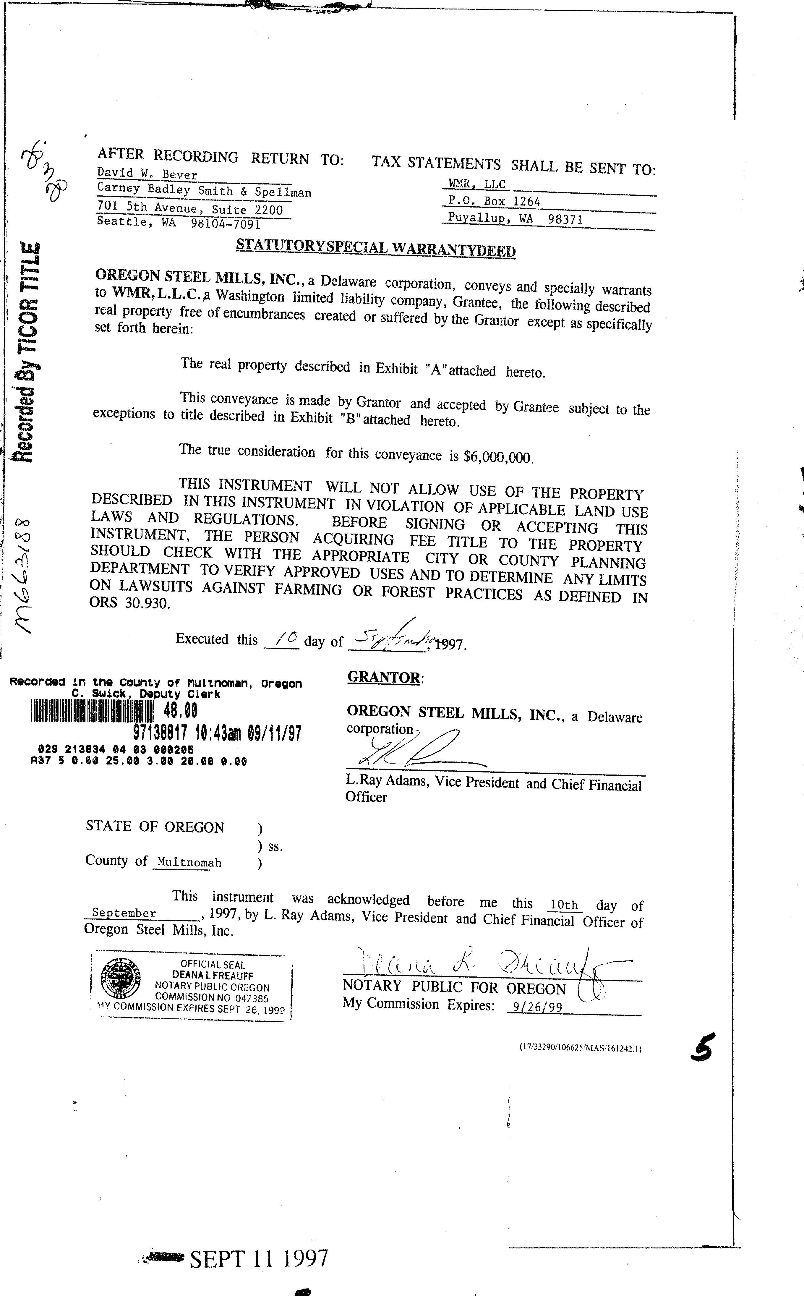
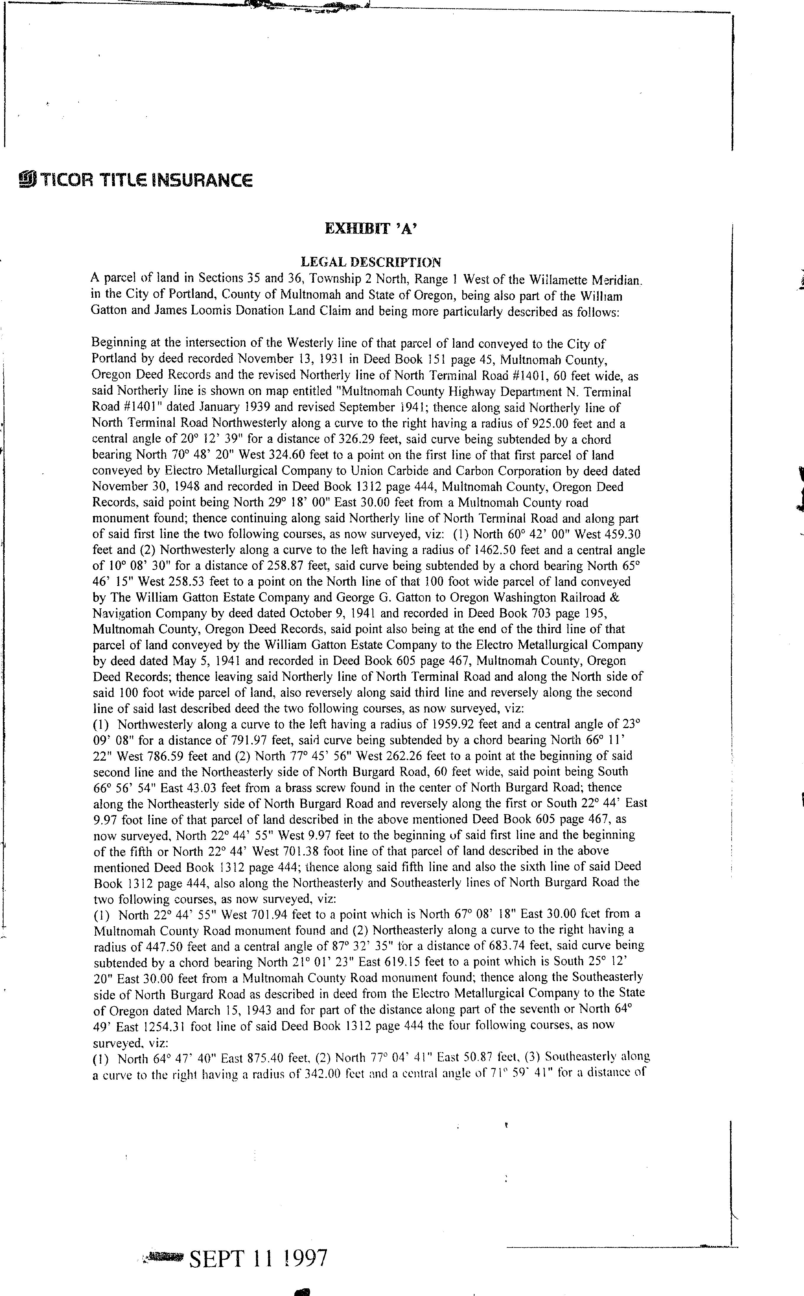
Vesting Deed
The information contained is provided by WFG’s Customer Service Department to our customers, and while deemed reliable, is not guaranteed.
PropertyDetailReport
Owner:WmrLLC
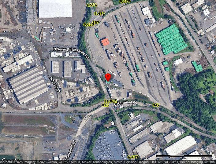
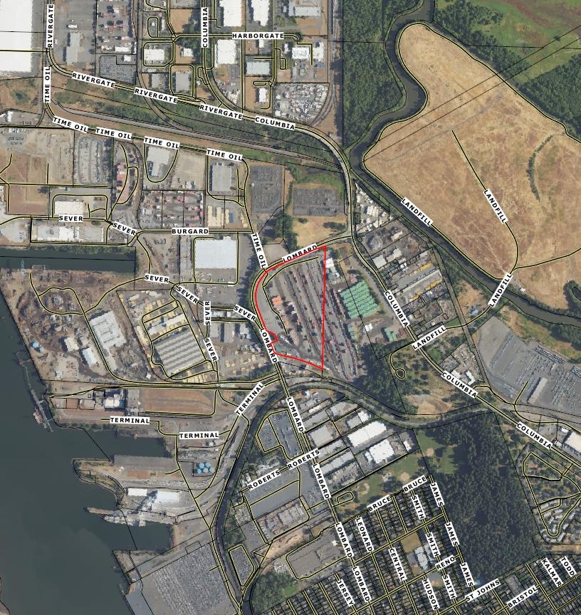
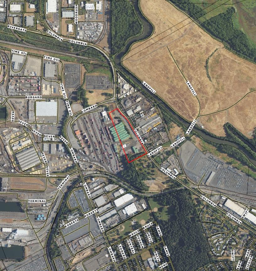
Site:11920NLombardStPortlandOR97203
Mail:3WaterwaySquarePl#110TheWoodlandsTX77380
LocationandSiteInformation
County: Multnomah
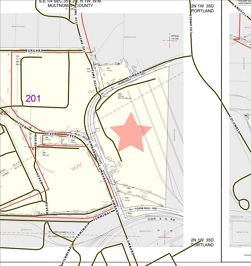
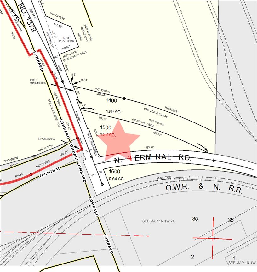
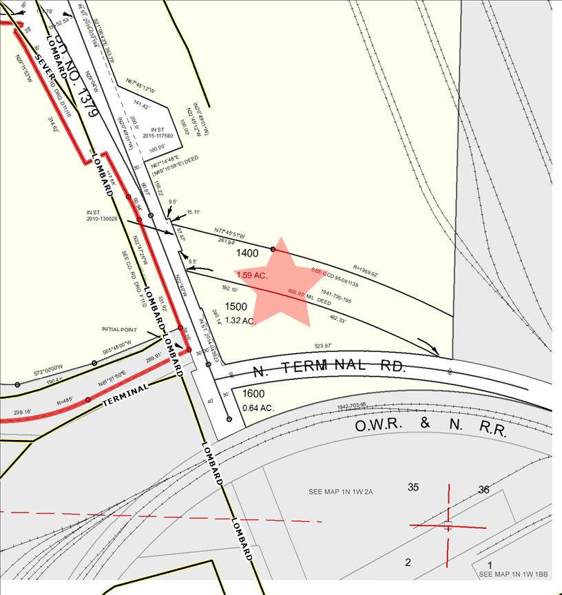
LegalDescription: SECTION352N1W,TL120028.63 ACRES,SPLITMAPR501677 (R971360410)
APN: R325486
TaxLot: 2N1W35D01200
Twn-Rng-Sec: 02N/01W/35/SE
Neighborhood: St Johns
Subdivision:
LegalLot/Block: 1
CensusTract/Block: 004104/1000
ElementarySchool: FaubionElementarySchool
MiddleSchool: FaubionElementarySchool
PropertyCharacteristics
TotalLivingArea: 5,440 Bedrooms:

LotSqFt: 1,247,171
LotAcres: 28.00
LandUse: 2013-Industrial,Manufacturing,Improved
LandUseSTD: Industrial(General)
CountyBldgUse: 5000-WhseGeneral/Misc
#Dwellings: 2
MapPage/Grid: 535-F7
Zoning: Portland-IH
Watershed: ColumbiaSlough-WillametteRiver
HighSchool: JeffersonHighSchool
SchoolDistrict: PortlandSchoolDistrict
FirstFloorSqFt: 5,440 BathroomsTotal: 1
YearBuilt/Eff: 1999
Heating: Forcedairunit
SecondFloorSqFt: BathroomsFull/Half: Cooling: BasementFin/Unfin: Stories: 1 Fireplace:
AtticFin/Unfin: Foundation: Pool: GarageSqFt: 800,000 RoofMaterial: RollComposition Kitchen: 0
AssessmentandTaxInformation
MarketTotal: $14,184,880.00
MarketLand: $10,725,670.00
MarketStructure: $3,459,210.00
AsssessmentYear: 2024
PropertyTax: $115,895.28
Exemption:
MarketImproved%: 24.00%
LevyCode: 201 AssessedTotal: $4,331,66000 MillRate: 267554
SaleandLoanInformation
SaleDate: 09/10/1997
SaleAmount: $6,000,00000
Document#: 97138817
DeedType: Deed
TitleCo:
Lender:
LoanAmount:
LoanType:
Price/SqFt: $1,102.94
SellerName: OREGONSTEELMILLSINC
PreparedBy:WFGNationalTitleCustomerServiceDepartment 12909SW68thPkwy,Suite350,Portland,OR97223 P:5036031700|3608915474E:cs@wfgnationaltitlecom|cccs@wfgtitlecom
SentryDynamics,Inc anditscustomersmakenorepresentation,warrantiesorconditions,expressorimplied, astotheaccuracyorcompletenessofinformationcontainedinthisreport
ParcelID:R325486
SiteAddress:11920NLombardSt
SentryDynamics,Inc anditscustomersmakenorepresentations, warrantiesorconditions,expressorimplied,astotheaccuracyor completenessofinformationcontainedinthisreport
ParcelID:R325486
SentryDynamics,Inc anditscustomersmakenorepresentations, warrantiesorconditions,expressorimplied,astotheaccuracyor completenessofinformationcontainedinthisreport
PropertyDetailReport
Owner:WmrLLC
Site:11920Wi/NLombardStPortlandOR97203
Mail:3WaterwaySquarePl#110TheWoodlandsTX77380
LocationandSiteInformation
County: Multnomah
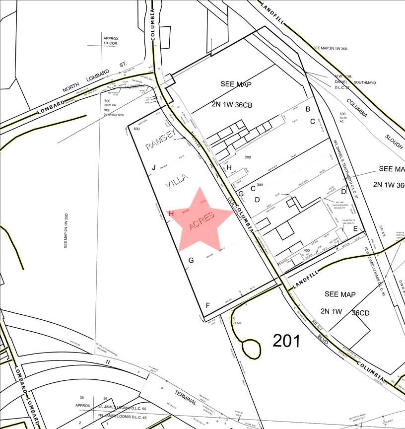
LegalDescription: RAMSEYVILLAAC,LOTF-H&JTL600
APN: R251997
TaxLot: 2N1W36C00600
Twn-Rng-Sec: 02N/01W/36/SW
Neighborhood: St Johns
Subdivision: RamseyVillaAc
LegalLot/Block: F-H,J
LotSqFt: 675,688
LotAcres: 15.00
LandUse: 2013-Industrial,Manufacturing,Improved
LandUseSTD: Industrial(General)
CountyBldgUse: 5000-WhseGeneral/Misc
#Dwellings:
MapPage/Grid: 535-G7
Zoning: Portland-IH CensusTract/Block: 004104/1000
Watershed: ColumbiaSlough-WillametteRiver
ElementarySchool: FaubionElementarySchool HighSchool: JeffersonHighSchool MiddleSchool: FaubionElementarySchool SchoolDistrict: PortlandSchoolDistrict
PropertyCharacteristics
TotalLivingArea: 6,300 Bedrooms:
YearBuilt/Eff: 2009
FirstFloorSqFt: 6,300 BathroomsTotal: Heating: SecondFloorSqFt: BathroomsFull/Half: Cooling: BasementFin/Unfin: Stories: 1 Fireplace:
AtticFin/Unfin: Foundation: Pool: GarageSqFt: 395,000 RoofMaterial: Kitchen: 0
AssessmentandTaxInformation
2024
SaleandLoanInformation
SaleDate: 09/10/1997
SaleAmount: $6,000,00000
Lender:
LoanAmount: Document#: 97138817
DeedType: Deed
LoanType:
Price/SqFt: $95238
TitleCo: SellerName: OREGONSTEELMILLSINC
PreparedBy:WFGNationalTitleCustomerServiceDepartment 12909SW68thPkwy,Suite350,Portland,OR97223 P:5036031700|3608915474E:cs@wfgnationaltitlecom|cccs@wfgtitlecom
SentryDynamics,Inc anditscustomersmakenorepresentation,warrantiesorconditions,expressorimplied, astotheaccuracyorcompletenessofinformationcontainedinthisreport
ParcelID:R251997
SiteAddress:11920Wi/NLombardSt
SentryDynamics,Inc anditscustomersmakenorepresentations, warrantiesorconditions,expressorimplied,astotheaccuracyor completenessofinformationcontainedinthisreport
ParcelID:R251997
SentryDynamics,Inc anditscustomersmakenorepresentations, warrantiesorconditions,expressorimplied,astotheaccuracyor completenessofinformationcontainedinthisreport
PropertyDetailReport
Owner:WmrLLC
Site:11920Wi/NLombardStPortlandOR97203
Mail:3WaterwaySquarePl#110TheWoodlandsTX77380
LocationandSiteInformation
County: Multnomah
LegalDescription: SECTION362N1W,TL70029.31 ACRES,SPLITMAPR325486 (R971350130)
APN: R501677
LotSqFt: 1,276,937
LotAcres: 29.00
LandUse: 2013-Industrial,Manufacturing,Improved TaxLot: 2N1W36C00700
Twn-Rng-Sec: 02N/01W/36/SW
Neighborhood: St Johns
LandUseSTD: Industrial(General)
CountyBldgUse: 5000-WhseGeneral/Misc
#Dwellings: Subdivision: MapPage/Grid: 535-G7
LegalLot/Block: 1
CensusTract/Block: 004104/1000
ElementarySchool: FaubionElementarySchool
Zoning: Portland-IH
Watershed: ColumbiaSlough-WillametteRiver
HighSchool: JeffersonHighSchool
MiddleSchool: FaubionElementarySchool SchoolDistrict: PortlandSchoolDistrict
PropertyCharacteristics
TotalLivingArea: 11,305 Bedrooms:
YearBuilt/Eff: 1999
FirstFloorSqFt: 11,305 BathroomsTotal: Heating:
SecondFloorSqFt: BathroomsFull/Half: Cooling: BasementFin/Unfin: Stories: 1 Fireplace:
AtticFin/Unfin: Foundation: Pool: GarageSqFt: 360,000 RoofMaterial: Metal Kitchen: 0
AssessmentandTaxInformation
MarketTotal:
$11,118,440.00 PropertyTax: $105,619.60
MarketLand: $8,912,670.00 Exemption: MarketStructure: $2,205,770.00 MarketImproved%: 20.00%
AsssessmentYear: 2024
LevyCode: 201 AssessedTotal: $3,947,60000 MillRate: 267554
SaleandLoanInformation
SaleDate: 09/10/1997
SaleAmount: $6,000,00000
Document#: 97138817
DeedType: Deed
TitleCo:
Lender:
LoanAmount:
LoanType:
Price/SqFt: $530.74
SellerName: OREGONSTEELMILLSINC
PreparedBy:WFGNationalTitleCustomerServiceDepartment 12909SW68thPkwy,Suite350,Portland,OR97223 P:5036031700|3608915474E:cs@wfgnationaltitlecom|cccs@wfgtitlecom
SentryDynamics,Inc anditscustomersmakenorepresentation,warrantiesorconditions,expressorimplied, astotheaccuracyorcompletenessofinformationcontainedinthisreport
ParcelID:R501677
SiteAddress:11920Wi/NLombardSt
SentryDynamics,Inc anditscustomersmakenorepresentations, warrantiesorconditions,expressorimplied,astotheaccuracyor completenessofinformationcontainedinthisreport

ParcelID:R501677
SentryDynamics,Inc anditscustomersmakenorepresentations, warrantiesorconditions,expressorimplied,astotheaccuracyor completenessofinformationcontainedinthisreport
PropertyDetailReport
Owner:WmrLLC
Site:11920Wi/NLombardStPortlandOR97203
Mail:3WaterwaySquarePl#110TheWoodlandsTX77380
LocationandSiteInformation
County: Multnomah
LotSqFt: 72,726
LegalDescription: SECTION352N1W,TL15001.67ACRESLotAcres: 1.00
APN: R325491
LandUse: 2013-Industrial,Manufacturing,Improved TaxLot: 2N1W35D01500
Twn-Rng-Sec: 02N/01W/35/SE
LandUseSTD: Industrial(General)
CountyBldgUse: 5000-WhseGeneral/Misc
Neighborhood: St Johns #Dwellings:
Subdivision: MapPage/Grid: 565-F1
LegalLot/Block: 1
CensusTract/Block: 004104/1002
Zoning: Portland-IH
Watershed: ColumbiaSlough-WillametteRiver
ElementarySchool: FaubionElementarySchool HighSchool: JeffersonHighSchool
MiddleSchool: FaubionElementarySchool SchoolDistrict: PortlandSchoolDistrict
PropertyCharacteristics
TotalLivingArea: Bedrooms: YearBuilt/Eff: 2003
FirstFloorSqFt: BathroomsTotal: Heating: SecondFloorSqFt: BathroomsFull/Half: Cooling: BasementFin/Unfin: Stories: Fireplace: AtticFin/Unfin: Foundation: Pool: GarageSqFt: 30,000 RoofMaterial:
Kitchen: 0
AssessmentandTaxInformation
MarketTotal: $679,06000 PropertyTax: $12,26104
MarketLand: $492,950.00 Exemption:
AsssessmentYear:
SaleandLoanInformation
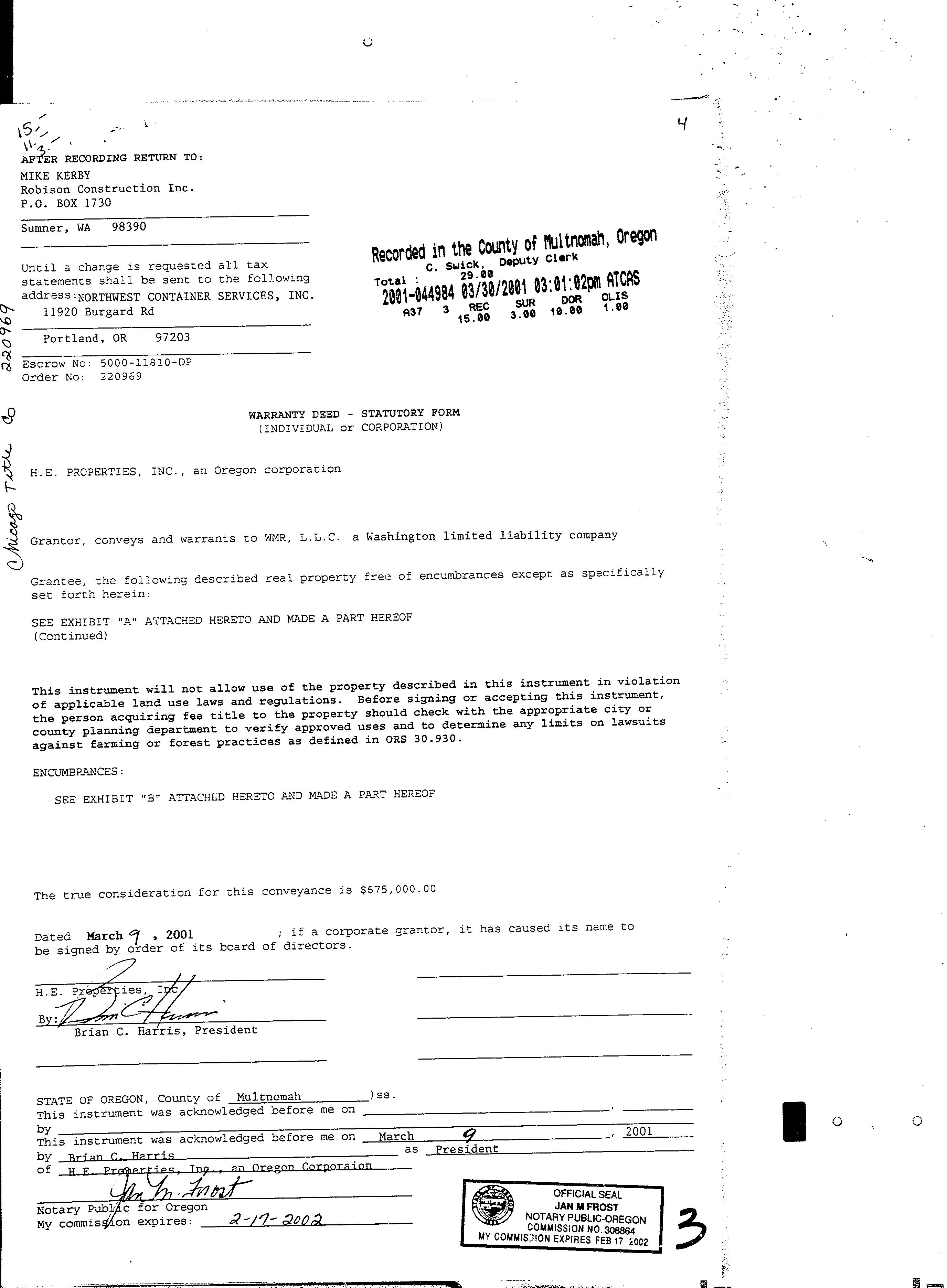
SaleDate: 03/09/2001
SaleAmount: $675,00000
Lender:
LoanAmount: Document#: 01044984
DeedType: Deed
TitleCo:
LoanType:
Price/SqFt: $000
SellerName: HEPROPERTIESINC
PreparedBy:WFGNationalTitleCustomerServiceDepartment 12909SW68thPkwy,Suite350,Portland,OR97223 P:5036031700|3608915474E:cs@wfgnationaltitlecom|cccs@wfgtitlecom
SentryDynamics,Inc anditscustomersmakenorepresentation,warrantiesorconditions,expressorimplied, astotheaccuracyorcompletenessofinformationcontainedinthisreport
ParcelID:R325491
SiteAddress:11920Wi/NLombardSt
SentryDynamics,Inc anditscustomersmakenorepresentations, warrantiesorconditions,expressorimplied,astotheaccuracyor completenessofinformationcontainedinthisreport
ParcelID:R325491
SentryDynamics,Inc anditscustomersmakenorepresentations, warrantiesorconditions,expressorimplied,astotheaccuracyor completenessofinformationcontainedinthisreport
PropertyDetailReport
Owner:WmrLLC
Site:11920Wi/NLombardStPortlandOR97203
Mail:3WaterwaySquarePl#110TheWoodlandsTX77380
LocationandSiteInformation
County: Multnomah
LotSqFt: 70,131
LegalDescription: SECTION352N1W,TL14001.61ACRESLotAcres: 1.00
APN: R325532
LandUse: 2013-Industrial,Manufacturing,Improved TaxLot: 2N1W35D01400
Twn-Rng-Sec: 02N/01W/35/SE
LandUseSTD: Industrial(General)
CountyBldgUse: 5000-WhseGeneral/Misc Neighborhood: St Johns #Dwellings:
Subdivision: MapPage/Grid: 565-F1
LegalLot/Block: 1
CensusTract/Block: 004104/1001
Zoning: Portland-IH
Watershed: ColumbiaSlough-WillametteRiver
ElementarySchool: FaubionElementarySchool HighSchool: JeffersonHighSchool
MiddleSchool: FaubionElementarySchool
PropertyCharacteristics
SchoolDistrict: PortlandSchoolDistrict
TotalLivingArea: 13,500 Bedrooms: YearBuilt/Eff: 2003
FirstFloorSqFt: 13,500 BathroomsTotal: Heating: SecondFloorSqFt: BathroomsFull/Half: Cooling:
BasementFin/Unfin: Stories: Fireplace: AtticFin/Unfin: Foundation: Pool: GarageSqFt: 48,000 RoofMaterial: Kitchen: 0
AssessmentandTaxInformation MarketTotal: $991,36000
SaleandLoanInformation
SaleDate: 03/30/2001
SaleAmount:
Document#: 01044982
DeedType: WD
TitleCo:
Lender:
LoanAmount:
LoanType:
Price/SqFt:
SellerName: HARRISENTERPRISESINC
PreparedBy:WFGNationalTitleCustomerServiceDepartment 12909SW68thPkwy,Suite350,Portland,OR97223 P:5036031700|3608915474E:cs@wfgnationaltitlecom|cccs@wfgtitlecom
SentryDynamics,Inc anditscustomersmakenorepresentation,warrantiesorconditions,expressorimplied, astotheaccuracyorcompletenessofinformationcontainedinthisreport
ParcelID:R325532
SiteAddress:11920Wi/NLombardSt
SentryDynamics,Inc anditscustomersmakenorepresentations, warrantiesorconditions,expressorimplied,astotheaccuracyor completenessofinformationcontainedinthisreport
ParcelID:R325532
SentryDynamics,Inc anditscustomersmakenorepresentations, warrantiesorconditions,expressorimplied,astotheaccuracyor completenessofinformationcontainedinthisreport
UTILITY
AS - BUILTS
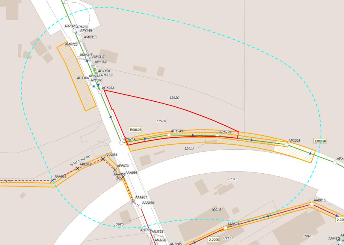
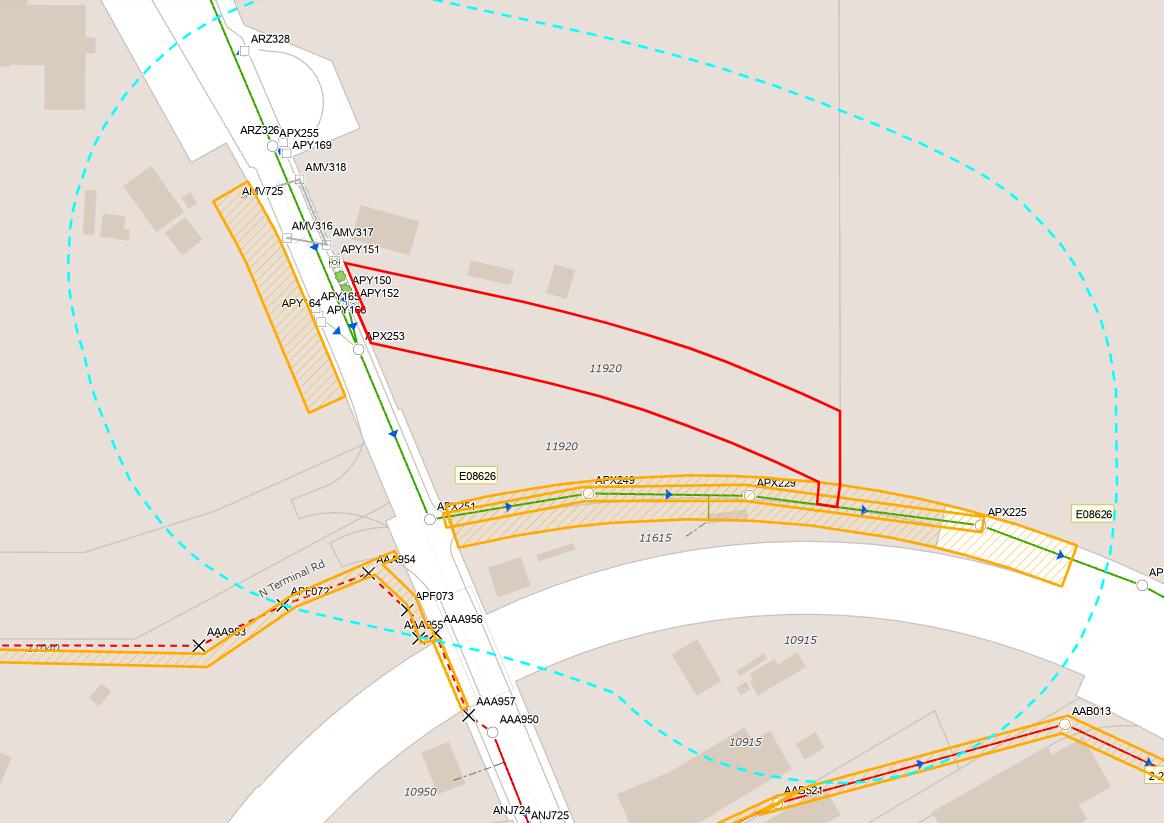
Water As-Built Maps
City of Portland
*Parcel size too large to show water lines, please contact City of Portland Water Bureau for more Information.
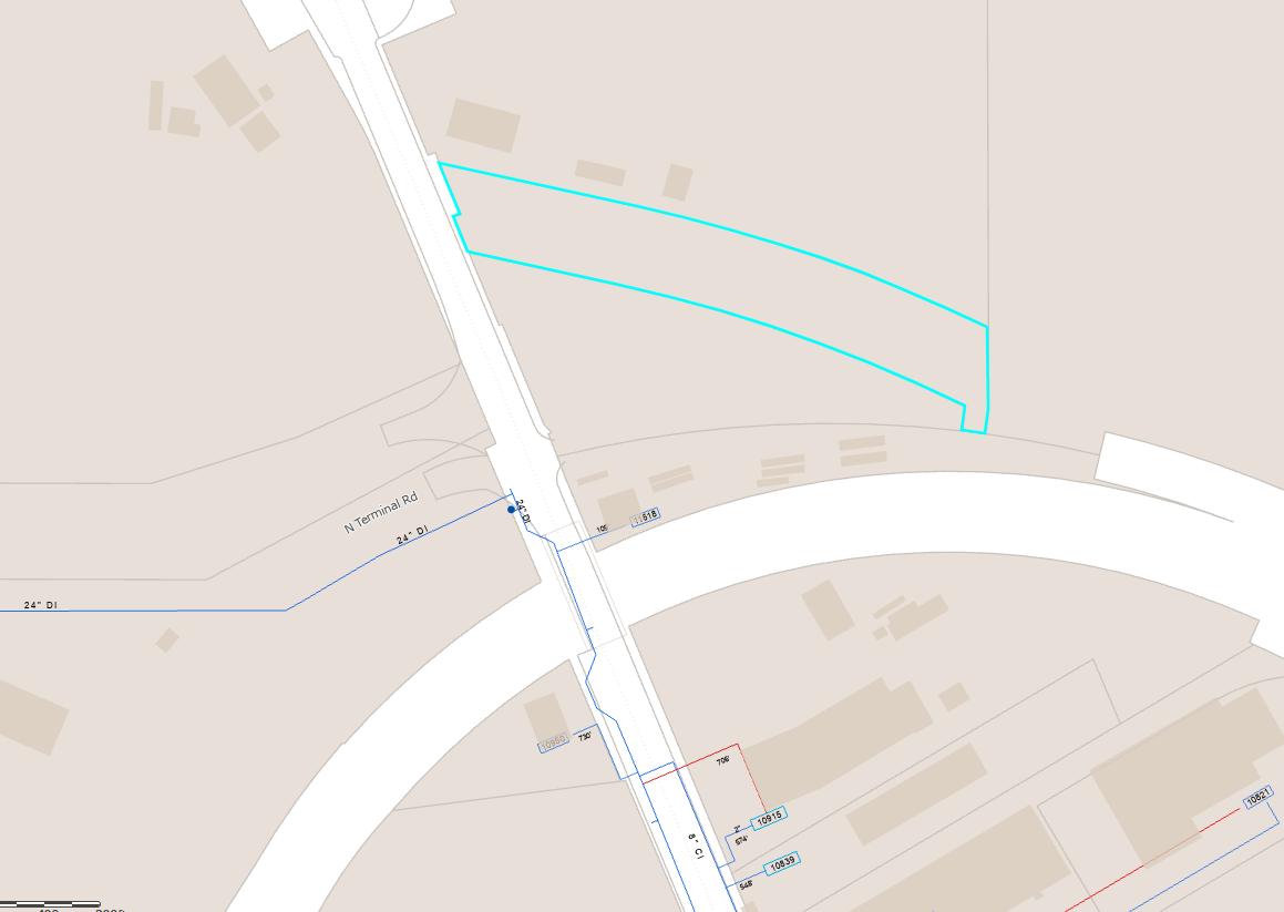
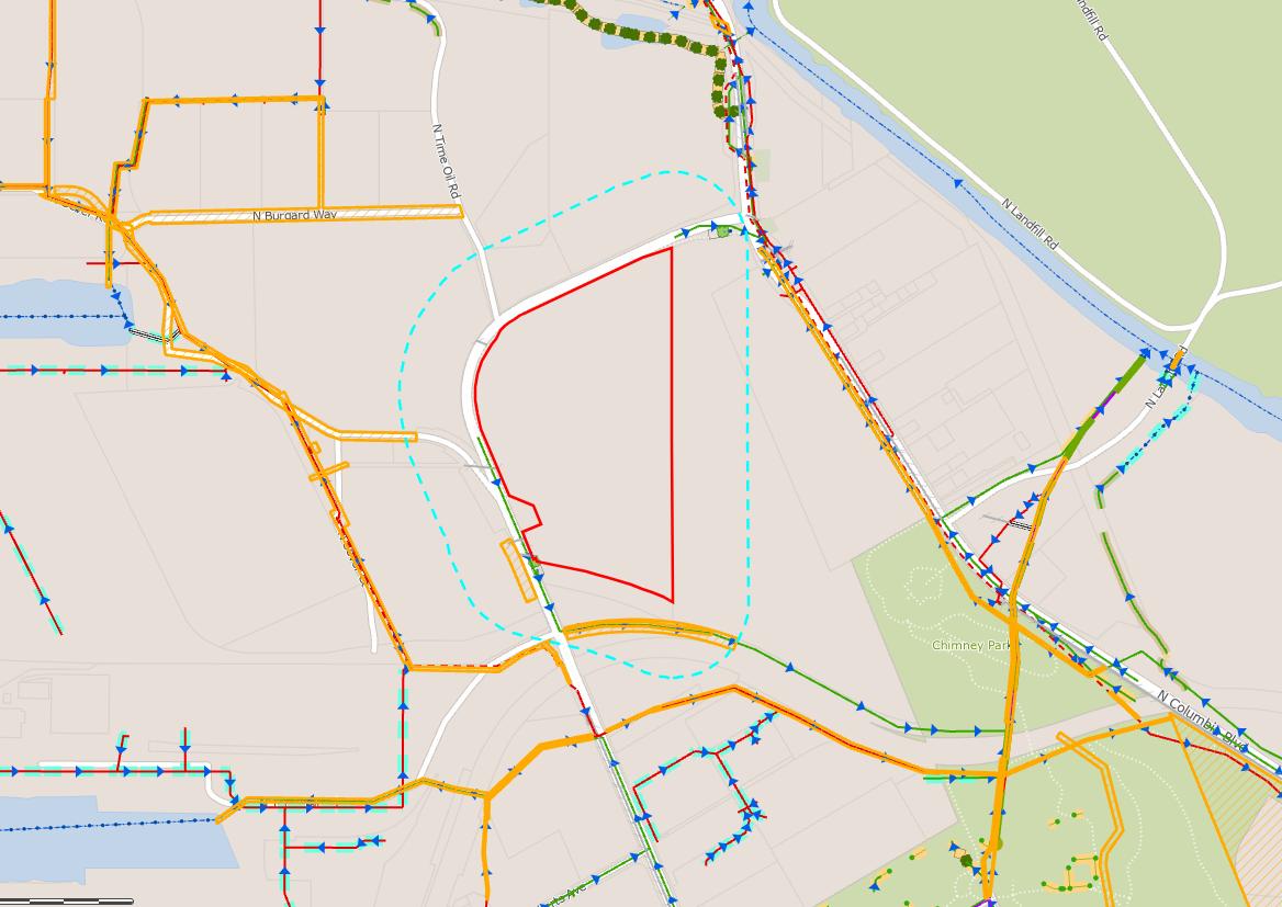
Sewer As-Built Maps
City of Portland
The information contained is provided by WFG’s Customer Service Department to our customers, and while deemed reliable, is not guaranteed.
WATER LINE MAP
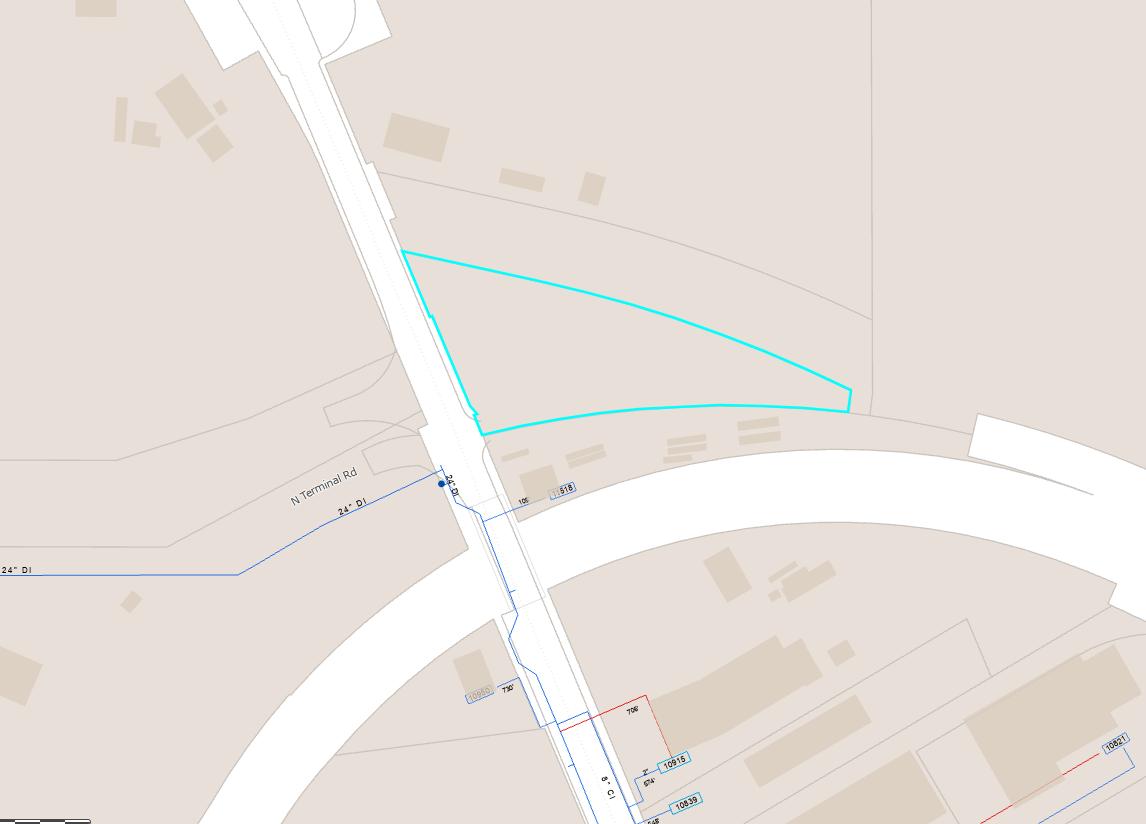
This map is a copy of public record and is provided solely for informational purposes.
WFG National Title assumes no liability for variations, if any, in dimensions, area or location of the premises or the location of improvements.
SEWER LINE MAP
This map is a copy of public record and is provided solely for informational purposes.
WFG National Title assumes no liability for variations, if any, in dimensions, area or location of the premises or the location of improvements.
WATER LINE MAP
This map is a copy of public record and is provided solely for informational purposes.
WFG National Title assumes no liability for variations, if any, in dimensions, area or location of the premises or the location of improvements.
SEWER LINE MAP
This map is a copy of public record and is provided solely for informational purposes.
WFG National Title assumes no liability for variations, if any, in dimensions, area or location of the premises or the location of improvements.
SEWER LINE MAP
This map is a copy of public record and is provided solely for informational purposes.
WFG National Title assumes no liability for variations, if any, in dimensions, area or location of the premises or the location of improvements.
SEWER LINE MAP
This map is a copy of public record and is provided solely for informational purposes.
WFG National Title assumes no liability for variations, if any, in dimensions, area or location of the premises or the location of improvements.
SEWER LINE MAP
This map is a copy of public record and is provided solely for informational purposes.
WFG National Title assumes no liability for variations, if any, in dimensions, area or location of the premises or the location of improvements.
ZONING
DETAILS
Detailed Zoning Information
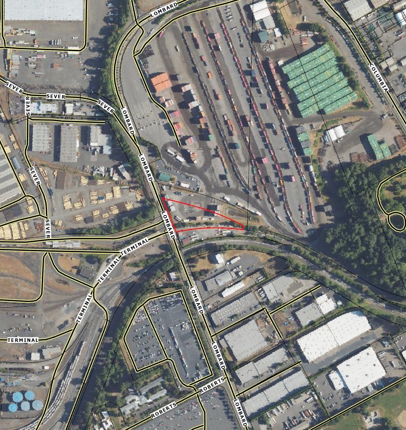
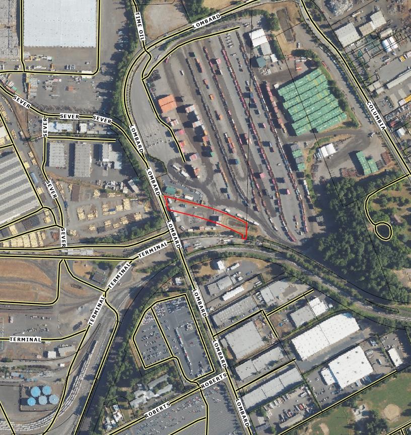
IH (Heavy Industrial) - Parcel 2N1W35D01200
Overlay K (Prime Industrial)
IH (Heavy Industrial) - Parcel 2N1W36C00600
Overlay K (Prime Industrial)
Overlay C (Environmental Conservation)
IH (Heavy Industrial) - Parcel 2N1W35D01500
Overlay K (Prime Industrial)
IH (Heavy Industrial) - Parcel 2N1W35D01400
Overlay K (Prime Industrial)
ZONING
DETAILS
Detailed Zoning Information Continued
IH (Heavy Industrial) - Parcel 2N1W36C00700
Overlay K (Prime Industrial)
Overlay C (Environmental Conservation)
Zoning Map
Community Jurisdiction
Title 33, Planning and Zoning
33.140 Employment and Industrial Zones
Sections:
General
33.140.010 General Purpose of the Zones
33.140.020 List of the Employment and Industrial Zones
33.140.030 Characteristics of the Zones
33.140.040 Other Zoning Regulations
33.140.050 Neighborhood Contact in EG and I Zones
33.140.055 Neighborhood Contact in EX Zone
Use Regulations
33.140.100 Primary Uses
33.140.110 Accessory Uses
33.140.140 On-Site Waste Disposal
Site Development Standards
33.140.200 Lot Size
33.140.205 Floor Area Ratio
33.140.210 Height
33.140.215 Setbacks
33.140.220 Building Coverage
33.140.225 Landscaped Areas
33.140.227 Trees
33.140.230 Windows in the EX Zones
33.140.235 Screening
33.140.240 Pedestrian Standards
33.140.242 Transit Street Main Entrance
33.140.245 Exterior Display, Storage, and Work Activities
33.140.250 Trucks and Equipment
33.140.255 Drive-Through Facilities
33.140.265 Residential Development
33.140.270 Detached Accessory Structures
33.140.275 Fences
33.140.280 Demolitions
33.140.290 Nonconforming Development
33.140.295 Parking, Loading, and Transportation and Parking Demand Management
33.140.300 Signs
33.140.310 Superblock Requirements
33.140.315 Recycling Areas
33.140.320 Inclusionary Housing
33.140.010 General Purpose of the Zones
The employment and industrial zones are for areas of the City that are reserved for industrial uses and for areas that have a mix of uses with a strong industrial orientation. The zones reflect the diversity of industrial and business areas in the City. The zones differ in the mix of allowed uses, the allowed intensity of development, and the development standards. The regulations promote areas which consist of uses and developments which will support the economic viability of the specific zoning district and of the City. The regulations protect the health, safety and welfare of the public, address area character, and address environmental concerns. In addition, the regulations provide certainty to property owners, developers, and neighbors about the limits of what is allowed.
33.140.020
List of the Employment and Industrial Zones
The full and short names of the employment and industrial zones and their map symbols are listed below. When this Title refers to the employment or E zones it is referring to the first three listed. When this Title refers to the industrial or I zones, it is referring to the last three listed.
33.140.030 Characteristics of
the Zones
A. General Employment. The General Employment zones implement the Mixed Employment map designation of the Comprehensive Plan. The zones allow a wide range of employment opportunities without potential conflicts from interspersed residential uses. The emphasis of the zones is on industrial, industrially-related, and office uses, typically in a low-rise, flexspace development pattern. Retail uses are allowed but limited in intensity to maintain adequate employment development opportunities. The development standards for each zone are intended to allow new development which is similar in character to existing development. The intent is to promote viable and attractive industrial/commercial areas.
1. General Employment 1. EG1 areas generally have smaller lots and a grid block pattern. The area is mostly developed, with sites having high building coverages and buildings which are usually close to the street. EG1 zoned lands will tend to be on strips or small areas.
2. General Employment 2. EG2 areas have larger lots and an irregular or large block pattern. The area is less developed, with sites having medium and low building coverages and buildings which are usually set back from the street. EG2 zoned lands will generally be on larger areas than those zoned EG1.
B. Central Employment. This zone implements the Central Employment map designation of the Comprehensive Plan. The zone allows mixed-uses and is intended for areas in the center of the City that have predominantly industrial type development. The intent of the zone is to allow industrial and commercial uses which need a central location. Residential
uses are allowed, but are not intended to predominate or set development standards for other uses in the area. The development standards are intended to allow new development which is similar in character to existing development.
C. General Industrial. The General Industrial zones are two of the three zones that implement the Industrial Sanctuary map designation of the Comprehensive Plan. The zones provide areas where most industrial uses may locate, while other uses are restricted to prevent potential conflicts and to preserve land for industry. The development standards for each zone are intended to allow new development which is similar in character to existing development. The intent is to promote viable and attractive industrial areas.
1. General Industrial 1. IG1 areas generally have smaller lots and a grid block pattern. The area is mostly developed, with sites having high building coverages and buildings which are usually close to the street. IG1 areas tend to be the City's older industrial areas.
2. General Industrial 2. IG2 areas generally have larger lots and an irregular or large block pattern. The area is less developed, with sites having medium and low building coverages and buildings which are usually set back from the street.
D. Heavy Industrial. This zone is one of the three zones that implement the Industrial Sanctuary map designation of the Comprehensive Plan. The zone provides areas where all kinds of industries may locate including those not desirable in other zones due to their objectionable impacts or appearance. The development standards are the minimum necessary to assure safe, functional, efficient, and environmentally sound development.
33.140.040 Other Zoning Regulations
The regulations in this chapter state the allowed uses and the development standards for the base zones. Sites in overlay zones or plan districts and designated historical landmarks are subject to additional regulations which supersede those of this Chapter. The Official Zoning Maps indicated which sites are subject to the additional regulations. Specific uses or development types may also be subject to regulations in the 200s series of chapters.
33.140.050 Neighborhood Contact in EG and I Zones
A. Purpose. Neighborhood contact is required when a new storage structure for any type of fuel will be built on a Bulk Fossil Fuel Terminal because of the impacts that fuel projects can have on the surrounding community.
B. Neighborhood contact requirement. Proposals meeting the following conditions are subject to the neighborhood contact steps of 33.705.020.B., Neighborhood Contact II. All of the steps in 33.705.020.B must be completed before an application for a building permit can be submitted
1. The proposed development has not been subject to a land use review; and
2. The proposed development includes at least one new structure for the storage of any type of fuel on a site with a Bulk Fossil Fuel Terminal use.
33.140.055
Neighborhood Contact in EX Zone
Neighborhood contact is a set of outreach steps that must be taken before certain developments can be submitted for approval. Neighborhood contact is required as follows:
A. Neighborhood contact I.
1. Neighborhood contact I requirements. When proposed development will add at least 10,000 square feet and not more than 25,000 square feet of net building area to a site, the neighborhood contact steps of 33.705.020.A., Neighborhood contact I, are required. All the steps in 33.705.020.A. must be completed before an application for a building permit can be submitted.
2. Exemption. If the proposed development has already met the neighborhood contact requirements as part of a land use review process, it is exempt from the neighborhood contact requirements.
B. Neighborhood contact II.
1. Neighborhood contact II requirements. When the proposed development will add more than 25,000 square feet of net building area to a site, the neighborhood contact steps of 33.705.020.B., Neighborhood contact II, are required. All of the steps in 33.705.020.B. must be completed before an application for a building permit can be submitted.
2. Exemption. If the proposed development has already met the neighborhood contact requirements as part of a land use review process, it is exempt from the neighborhood contact requirements.
Use Regulations
33.140.100
Primary Uses
A. Allowed uses. Uses allowed in the employment and industrial zones are listed in Table 1401 with a "Y". These uses are allowed if they comply with the development standards and other regulations of this Title. Being listed as an allowed use does not mean that a proposed development will be granted an adjustment or other exception to the regulations of this Title. In addition, a use or development listed in the 200s series of chapters is also subject to the regulations of those chapters.
B. Limited uses. Uses allowed that are subject to limitations are listed in Table 140-1 with an "L". These uses are allowed if they comply with the limitations listed below and the development standards and other regulations of this Title. In addition, a use or development listed in the 200s series of chapters is also subject to the regulations of those chapters. The paragraphs listed below contain the limitations and correspond with the footnote numbers from Table 140-1.
1. Household Living and Group Living uses in EGI and EG2 zones. This regulation applies to all parts of Table 140-1 that have a [1].
a. Limited use. Household Living and Group Living are allowed uses when an existing hotel or motel is converted to dwelling units and all of the converted
dwelling units are affordable to those earning no more than 60 percent of the area median family income. The property owner must execute a covenant with the City that meets the requirements of Section 33.700.060. The covenant must reflect that all dwelling units will be affordable at the specified income level for a minimum of 30 years.
b. Prohibited use. Except as specified in Subparagraph B.1.a, Household Living and Group Living use are prohibited.
2. Household Living and Group Living uses in I zones. This regulation applies to all parts of Table 140-1 that have a [2]. Household Living and Group Living in houseboats and houseboat moorages in I zones are regulated by Chapter 33.236, Floating Structures. Household and Group Living in other structures is prohibited.
3. EG Retail Sales And Service limitation. The following regulations apply to all parts of Table 140-1 that have a [3].
a. Limited uses. Except for sites with historic landmarks, the net building area plus any exterior display, storage, work and other exterior activity area for Retail Sales And Service uses is limited to 20,000 square feet or the square footage of the site area, whichever is less. On sites with historic landmarks, the net building area plus any exterior display, storage, work and other exterior activity area for Retail Sales And Service uses is limited to 20,000 square feet or twice the total square footage of the site area, whichever is less
b. Conditional uses. Retail Sales And Service uses that exceed the area limits in Subparagraph B.2.a. are a conditional use.
4. IG1 commercial limitation. This regulation applies to all parts of Table 140-1 that have a [4].
a. Limited uses. One Retail Sales And Service or Office use is allowed per site. The square footage of net building area plus the exterior display, storage, work and other exterior activity area may be up to 3,000 square feet.
b. Conditional uses.
(1) More than one Retail Sales And Service or Office Use on a site is a conditional use.
(2) Any Retail Sales And Service or Office Use where the net building area plus the exterior display, storage, work and other exterior activity area is more than 3,000 square feet is a conditional use.
c. Prohibited uses.
(1) Except for sites with a historic landmark, the net building area of all the Retail Sales And Service and Office uses on a site plus exterior display, storage, work and other exterior activity area, taken together, may not exceed 20,000 square feet or the square footage of the site area, whichever is less. Retail Sales And Service and Office uses that exceed these area limits are prohibited
(2) For sites with a historic landmark, the net building area of all the Retail Sales And Service and Office uses on a site plus the exterior display, storage, work and other exterior activity area, taken together, may not exceed 60,000 square feet or twice the square footage of the site area, whichever is less. Retail Sales And Service and Office uses that exceed these area limits are prohibited.
5. IG2 commercial limitation. This regulation applies to all parts of Table 140-1 that have a [5].
a. Limited uses. Up to four Retail Sales And Service or Office uses are allowed per site. The square footage of the net building area plus the exterior display, storage, work and other exterior activity area may be up to 3,000 square feet per use.
b. Conditional uses.
(1) More than four Retail Sales And Service or Office uses on a site is a conditional use.
(2) Any Retail Sales And Service or Office use where the net building area plus the exterior display, storage, work and other exterior activity area is more than 3,000 square feet is a conditional use.
c. Prohibited uses.
(1) Except for sites with a historic landmark, the net building area of all the Retail Sales And Service and Office uses on a site plus the exterior display, storage, work and other exterior activity area, taken together, may not exceed 20,000 square feet or the square footage of the site area, whichever is less. Retail Sales And Service and Office uses that exceed these area limits are prohibited.
(2) For sites with a historic landmark, the net building area of all the Retail Sales And Service and Office uses on a site plus the exterior display, storage, work and other exterior activity area, taken together, may not exceed 60,000 square feet or twice the square footage of site area, whichever is less. Retail Sales And Service and Office uses that exceed these area limits are prohibited.
6. IH commercial limitation. This regulation applies to all parts of Table 140-1 that have a [6].
a. Limited uses. Up to four Retail Sales And Service or Office uses are allowed per site. The square footage of the net building area plus the exterior display, storage, work and other exterior activity area may be up to 3,000 square feet per use.
b. Conditional uses.
(1) More than four Retail Sales And Service or Office use on a site is a conditional use.
(2) Any Retail Sales And Service or Office use where the net building area plus the exterior display, work and other exterior activity storage area is more than 3,000 square feet is a conditional use.
c. Prohibited uses.
(1) Except for sites with a historic landmark, the net building area of all the Retail Sales And Service and Office uses on a site plus the exterior display, storage, work and other exterior activity area, taken together, may not exceed 12,000 square feet or the square footage of the site area, whichever is less. Retail Sales And Service and Office uses that exceed these area limits are prohibited.
(2) For sites with a historic landmark, the net building area of all the Retail Sales And Service and Office uses on a site plus the exterior display, storage, work and other exterior activity area, taken together, may not exceed 25,000 square feet or twice the square footage of site area, whichever is less. Retail Sales And Service and Office uses that exceed these area limits are prohibited.
7. Self-Service Storage limitation. This regulation applies to all parts of Table 140-1 that have a [7]. The limitations are stated with the special regulations for these uses in Chapter 33.284, Self-Service Storage.
8. Waste-Related limitation. This regulation applies to all parts of Table 140-1 that have a [8]. All Waste-Related uses are conditional uses, unless they meet all of the following conditions in which case they are allowed by right.
a. The use must be approved by Metro under their authority as prescribed in ORS 268.317;
b. Metro’s approval of the use must include a mitigation plan. The requirements for the mitigation plan must be approved by the City Council through an intergovernmental agreement with Metro, adopted prior to Metro’s approval of the use; and
c. The location of the use must be in conformance with Metro’s Regional Solid Waste Management Plan.
9. Community Service uses in E zones. This regulation applies to all parts of Table 140-1 that have a [9]. Most Community Service uses are allowed by right. Short term, mass, and outdoor shelters are regulated by Chapter 33.285, Short Term, Mass, and Outdoor Shelters.
Table 140-1
Employment and Industrial Zone Primary Uses
Y = Yes, Allowed CU = Conditional Use Review Required
Notes:
L = Allowed, But Special Limitations N = No, Prohibited
• The use categories are described in Chapter 33.920.
• Regulations that correspond to the bracketed numbers [ ] are stated in 33.140.100.B.
• Specific uses and developments may also be subject to regulations in the 200s series of chapters.
140-1
Rail Lines And Utility Corridors Y Y Y Y Y Y Y = Yes, Allowed CU = Conditional Use Review Required L = Allowed, But Special Limitations N = No, Prohibited
Notes:
• The use categories are described in Chapter 33.920.
• Regulations that correspond to the bracketed numbers [ ] are stated in 33.140.100.B.
• Specific uses and developments may also be subject to regulations in the 200s series of chapters.
10. Daycare and Community Service in the I zones. This regulation applies to all parts of Table 140-1 that have a [10].
a. Short term and mass shelters are prohibited. Outdoor shelters are regulated by Chapter 33.285, Short Term, Mass, and Outdoor Shelters.
b. Daycare and all other Community Service uses up to 3,000 square feet of net building area are allowed. Uses larger than 3,000 square feet of net building area are a conditional use.
11. Basic Utilities in E zones. This regulation applies to all parts of Table 140-1 that have a [11]. Public safety facilities that include Radio Frequency Transmission Facilities are subject to the regulations of Chapter 33.274. All other Basic Utilities are allowed.
12. Basic Utilities in I zones. This regulation applies to all parts of Table 140-1 that have a [12]. Public safety facilities that include Radio Frequency Transmission Facilities are subject to the regulations of Chapter 33.274. Public safety facilities which have more
Chapter 33.140
than 3,000 square feet of floor area are a conditional use. The approval criteria are in Section 33.815.223. All other Basic Utilities are allowed.
13. Radio Frequency Transmission Facilities. This regulation applies to all parts of Table 140-1 that have a [13]. Some Radio Frequency Transmission Facilities are allowed by right. See Chapter 33.274.
14. Commercial Parking. This regulation applies to all parts of Table 140-1 that have a [14]. Except where plan district provisions supersede these regulations, Commercial Parking is a conditional use in the E and I zones. Within plan districts, there may be special regulations.
15. Agriculture. This regulation applies to all parts of Table 140-1 that have a [15]. Agriculture is an allowed use. Where the use and site meet the regulations of Chapter 33.237, Food Production and Distribution, the applicant may choose whether it is allowed as a Market Garden.
16. Bulk Fossil Fuel Terminals. This regulation applies to all parts of Table 140-1 that have a [16].
a. Existing Bulk Fossil Fuel Terminals. Bulk Fossil Fuel Terminals that existed on August 31, 2022 are allowed, but the total amount of fossil fuel that can be stored on the site in storage tanks is limited to the fossil fuel storage tank capacity that existed on August 31, 2022. Total fossil fuel storage tank capacity on the site in excess of the capacity that existed on August 31, 2022 is prohibited. Adding storage tank capacity exclusively for renewable fuels or to comply with the Renewable Fuel Standard (PCC Chapter 16.60 Motor Vehicle Fuels) is not considered an increase in capacity. Storing coal on the site is prohibited.
b. New Bulk Fossil Fuel Terminals are prohibited.
C. Conditional uses. Uses which are allowed if approved through the conditional use review process are listed in Table 140-1 with a "CU". These uses are allowed provided they comply with the conditional use approval criteria for that use, the development standards, and other regulations of this Title. Uses listed with a "CU" that also have a footnote number in the table are subject to the regulations cited in the footnote. In addition, a use or development listed in the 200s series of chapters is also subject to the regulations of those chapters. The conditional use review process and approval criteria are stated in Chapter 33.815, Conditional Uses.
D. Prohibited uses. Uses listed in Table 140-1 with an "N" are prohibited. Existing uses in categories listed as prohibited may be subject to the regulations of Chapter 33.258, Nonconforming Uses and Development.
33.140.110 Accessory Uses. Uses that are accessory to a primary use are allowed if they comply with specific regulations for the accessory uses and all development standards.
33.140.140 On-Site Waste Disposal
On-site disposal of solid wastes generated by a use is subject to the same regulations as for uses in the Waste-Related use category. See Table 140-1.
33.140.200 Lot Size
Development Standards
Lot size regulations are in Chapters 33.614 and 33.615.
33.140.205
Floor Area Ratio
A. Purpose. Floor area ratios (FARs) regulate the amount of use (the intensity) allowed on a site. FARs provide a means to match the potential amount of uses with the desired character of the area and the provision of public services. FARs also work with the height, setback, and building coverage standards to control the overall bulk of development.
B. The floor area standards. The FARs are stated in Table 140-2. The FAR standards of plan districts supersede the FAR standards of this chapter.
C. Bonus FAR. In the EX zone, bonus FAR is allowed as follows. Sites in the other employment and industrial zones are not eligible to use the bonus options. Adjustments to this Subsection, or to the maximum floor area allowed through the following bonuses, are prohibited:
1. Mandatory inclusionary housing. Bonus FAR is allowed up to the maximum FAR with inclusionary housing bonus stated in Table 140-2 for development that triggers the requirements of 33.245, Inclusionary Housing. The amount of bonus floor area allowed is an amount equal to the net building area of the building that triggers 33.245, up to the maximum FAR with bonus stated in Table 140-2. To qualify for this bonus, the applicant must provide a letter from the Portland Housing Bureau certifying that the regulations of 33.245 have been met.
2. Voluntary inclusionary housing. Bonus FAR up to the maximum FAR with inclusionary housing bonus stated in Table 140-2 is allowed when one of the following is met:
a. Bonus FAR is allowed for projects that voluntarily comply with the standards of 33.245.040 and 33.245.050. The amount of bonus floor area allowed is an amount equal to the net building area of the building that complies with 33.245.040 and .050, up to the maximum FAR with bonus stated in Table 140-2. To qualify for this bonus, the applicant must provide a letter from the Portland Housing Bureau certifying that the regulations of 33.245 have been met. The letter is required to be submitted before a building permit can be issued for development, but is not required in order to apply for a land use review; or
b. Bonus FAR is allowed in exchange for payment into the Affordable Housing Fund. For each square foot of floor area purchased a fee must be paid to the Portland Housing Bureau (PHB). The Portland Housing Bureau collects and administers the Affordable Housing Fund, and determines the fee. PHB determines the fee per square foot and updates the fee at least every three years. The fee schedule is available from Portland Permitting & Development. To qualify for this bonus, the applicant must provide a letter from PHB documenting the amount that has been contributed. The letter is required to be submitted before a building permit can be issued for development, but is not required in order to apply for a land use review.
D. Transfer of FAR from historic resources in the EX Zone. Floor area ratios may be transferred from a site zoned EX that contains a Historic or Conservation Landmark or contributing resource in a Historic or Conservation District as follows:
1. Maximum increase in FAR. An increase in FAR on the receiving site of more than 3 to 1 is prohibited. The total increased FAR includes FAR transferred from historic resources, and additional FAR allowed at the receiving site from bonus provisions, or from other transfers.
2. Development standards. The building on the receiving site must meet the development standards of the base zone, overlay zone, and plan district except floor area ratio, which is regulated by Subsection C;
3. Receiving site. The transfer must be to a site that is:
a. Zoned C or EX; and
b. Within the recognized neighborhood where the Historic or Conservation Landmark or contributing resource in a Historic or Conservation District is located, or to any site within two miles of the Historic or Conservation Landmark or contributing resource in a Historic or Conservation District; and
4. The property owner executes a covenant with the City that is attached to and recorded with the deed of both the site transferring and the site receiving the density reflecting the respective increase and decrease of potential FAR The covenants for both sites must meet the requirements of Section 33.700.060, Covenants with the City.
E. Transfer of FAR from historic resources in the EG Zones. Floor area may be transferred from a site zoned EG1 or EG2 that contains a Historic or Conservation Landmark or contributing resource in a Historic or Conservation District as follows:
1. Maximum increase in FAR. An increase in FAR on the receiving site of more than 3 to 1 is prohibited. The total increased FAR includes FAR transferred from historic resources, and additional FAR allowed at the receiving site from bonus provisions, or from other transfers.
2. Development standards. The building on the receiving site must meet the development standards of the base zone, overlay zone, and plan district except floor area ratio, which is regulated by Subsection C;
3. Receiving site. The transfer must be to a site that is:
a. Zoned EG1 or EG2; and
b. Within the recognized neighborhood where the Historic or Conservation Landmark or contributing resource in a Historic or Conservation District is located, or to any site within two miles of the Historic or Conservation Landmark or contributing resource in a Historic or Conservation District; and
4. The property owner executes a covenant with the City that is attached to and recorded with the deed of both the site transferring and the site receiving the density reflecting the respective increase and decrease of potential FAR. The covenants for
both sites must meet the requirements of Section 33.700.060, Covenants with the City.
33.140.210 Height
A. Purpose. The height standards work with the FAR, building setback, and building coverage standards to control the overall bulk and intensity of an area. The EG1 zone height limit is the same as the General Commercial zone because the EG1 zone often functions as a transition zone between industrial and residential or commercial zones. The EX zone height limit reflects its use in intense urban areas and the range of uses that are allowed. The other zones do not have height limits because tall buildings in these areas have traditionally not been a problem.
B. The height standard. The height limits for all structures, except detached accessory structures, are stated in Table 140-2. The height standards for detached accessory structures are stated in 33.140.270 Exceptions to the maximum height standard are stated below.
1. Projections allowed. Chimneys, flag poles, satellite receiving dishes, and other similar items attached to a building, with a width, depth, or diameter of 5 feet or less may rise 10 feet above the height limit, or 5 feet above the highest point of the roof, whichever is greater. If they are greater than 5 feet in width, depth, or diameter, they are subject to the height limit.
2. Parapets and rooftop railings may extend 4 feet above the height limit.
3. Rooftop mechanical equipment and stairwell enclosures that provide rooftop access may extend above the height limit as follows, provided that the equipment and enclosures are set back at least 15 feet from all roof edges on street facing facades:
a. Elevator mechanical equipment may extend up to 16 feet above the height limit; and
b. Other mechanical equipment and stairwell enclosures that cumulatively cover no more than 10 percent of the roof area may extend up to 10 feet above the height limit
4. Antennas, utility power poles, and public safety facilities are exempt from the height limit.
5. Small wind turbines are subject to the standards of Chapter 33.299.
6. Roof mounted solar panels are not included in height calculations, and may exceed the maximum height limit if the following are met:
a. For flat roofs or the horizontal portion of mansard roofs, they may extend up to 5 feet above the top of the highest point of the roof.
b. For pitched, hipped, or gambrel roofs, they must be mounted no more than 12 inches from the surface of the roof at any point, and may not extend above the ridgeline of the roof. The 12 inches is measured from the upper side of the solar panel.
Chapter 33.140
Maximum FAR (see 33.140.205)
Maximum FAR with Inclusionary Housing Bonus (see 33.140.205.C)
Maximum Height (see 33.140.210)
Min. Building Setbacks Street Lot Line (see 33.140.215)
- Lot line abutting an OS, C, E, or I zoned lot
- Lot line abutting an R zoned lot
Max. Building Stbks (see 33.140.215) Transit Street or Pedestrian District
Maximum Building Coverage (see 33.140.220)
Min. Landscaped Area (see 140.225)
Ground Floor Window Standards apply (see 33.140.230)
Pedestrian Standards Apply (see 33.140.240)
Table
Table 140-2
Development Standards
Table 140-3
Minimum Building Setbacks and Minimum Landscape Buffer From Residential Zone Lot Lines [1]
Notes: [1] Does not apply to lot lines that abut lots in the RX zone. See
33.140.215
Setbacks
A. Purpose. The setback standards promote different streetscapes. The EG2 and IG2 zone setbacks promote a spacious style of development. The EG1, IG1, and EX zone setbacks reflect the generally built-up character of these areas. The IH zone requires only a minimal setback to separate uses from the street. The setback standards are also intended to ensure that development will preserve light, air, and privacy for abutting residential zones. In the EG1 and EX zones, the setback requirements along transit streets and in Pedestrian Districts create an environment that is inviting to pedestrians and transit users.
B. Minimum building setbacks. The setback standards apply to all buildings and structures on the site except as specified in this section. Setbacks for exterior development are stated in 33.140.245 below, and for parking areas in Chapter 33.266.
1. Generally. The required building setbacks are stated in Table 140-2.
2. Lot line abutting R-zoned lot, except RX. Building setbacks and required landscape buffering on lot lines that abut lots in residential zones, except RX, are stated in Table 140-3. Required landscaped areas must comply with at least the L3 standard as stated in Chapter 33.248, Landscaping and Screening. Landscaping is not required where buildings abut a lot line.
3. Exceptions to the building setbacks.
a. Setback averaging. Outside of Pedestrian Districts and along non-transit streets, the street setback from a street lot line for buildings, decks, balconies, and porches may be reduced to the average of the existing respective setbacks on abutting lots. See Chapter 33.930, Measurements, for more information.
b. Split zoning. No setbacks are required from an internal lot line that is also a zoning line on sites with split zoning.
4. Extensions into required building setbacks.
a. The following features of a building may extend into a required building setback up to 20 percent of the depth of the setback. However, except for building eaves, they may not project into the landscape buffer required by Paragraph B.2.
(1) Eaves, chimneys, fireplace inserts and vents, mechanical equipment, fire escapes, water collection cisterns, and planters;
(2) Decks, stairways, wheelchair ramps, and uncovered balconies not meeting the standard of subparagraph B.4.b.; and
(3) Bays and bay windows extending into the setback also must meet the following requirements:
• Each bay and bay window may be up to 12 feet long, but the total area of all bays and bay windows on a building facade cannot be more than 30 percent of the area of the facade;
• At least 30 percent of the area of the bay which faces the property line requiring the setback must be glazing or glass block;
• Bays and bay windows must cantilever beyond the foundation of the building; and
• The bay may not include any doors.
b. The following minor features of a building are allowed to extend into required building setbacks but may not project into the landscaped buffer required by Paragraph B.2:
(1) Canopies, marquees, awnings, and similar features may fully extend into a street setback;
(2) Uncovered stairways and wheelchair ramps that lead to one entrance on the street-facing facade of a building may fully extend into a street setback;
(3) Uncovered decks, stairways, and wheelchair ramps that are no more than 21/2 feet above the ground may fully extend into a required building setback; and
(4) On lots that slope down from the street, vehicular and pedestrian entry bridges that are no more than 2-1/2 feet above the average sidewalk elevation may fully extend into a required building setback.
5. Detached accessory structures. For sites entirely in residential use, detached accessory structures are subject to the multi-dwelling zone standards of 33.120.280. The setback standards for detached accessory structures are stated in 33.140.270 below. Fences are addressed in 33.140.275 below.
C. Maximum building setbacks.
1. Building setbacks on a transit street or in a Pedestrian District. The maximum setback standards of this paragraph apply to buildings that are enclosed on all sides.
a. Where these standards apply. Except as provided in Subsection D. below, these setback standards apply to sites in the EG1 and EX zones.
b. Measurement.
(1) Where an existing building is being altered, the standards of this paragraph apply to the ground level, street-facing facade of the entire building. See Figures 140-1 and 140-2.
(2) Where there is more than one building on the site, the standards of this paragraph apply to the combined ground level, street-facing facades of all of the buildings on the site. See Figures 140-3 and 140-4.
(3) For buildings where all of the floor area is in residential use, the streetfacing facade of an open porch that meets the following standards is included as part of the ground level, street-facing facade of the building:
• For houses, attached houses, manufactured homes and duplexes, the porch must be at least 25 square feet in area. For multi-dwelling structures, the porch must be at least 9 feet wide and 7 feet deep;
• The porch must have at least one entrance facing the street; and
• The porch must have a roof that is:
No more than 12 feet above the floor of the porch; and At least 30 percent solid. This standard may be met by having 30 percent of the porch area covered with a solid roof, or by having the entire area covered with a trellis or other open material if no more than 70 percent of the area of the material is open.
c. Standards. There are two standards. Subparagraphs C.1.d. and e. specify where each standard applies:
(1) Standard 1: At least 50 percent of the length of the ground level streetfacing facade of the building must be within the maximum setback;
(2) Standard 2: 100 percent of the length of the ground level street-facing facade of the building must be within the maximum setback;
d. Outside a Pedestrian district. Where the site is not in a Pedestrian District:
(1) One transit street. Where the site is adjacent to one transit street, the standard of Standard 1 must be met on the transit street frontage;
(2) Two non-intersecting transit streets. Where the site is adjacent to two transit streets that do not intersect:
• Standard 1 must be met on the frontage of the transit street with the highest classification. If both streets have the same classification, the applicant may choose which street;
• If one of the transit streets intersects a City Walkway, Standard 1 must be met along both the transit street with the highest classification and the City Walkway;
(3) Two or more intersecting transit streets. Where the site is adjacent to two or more intersecting transit streets, Standard 2 must be met on the frontage of the transit street with the highest classification and Standard 1 must be met on an intersecting transit street. If two streets have the same highest classification, the applicant may choose which street.
e. In a Pedestrian District. Where the site is in a Pedestrian District:
(1) One street. Where the site is adjacent to only one street, Standard 1 must be met on that street frontage;
(2) Through lot with one transit street. Where the site is a through lot and one frontage is a transit street and one is a non-transit street, Standard 1 must be met on the frontage of the transit street;
(3) Through lot with two transit streets. Where the site is a through lot and both frontages are on transit streets, Standard 1 must be met on the frontage of the transit street with the highest classification. If both streets have the same classification, the applicant may choose which street;
(4) Through lot with no transit streets. Where the site is a through lot and neither frontage is on a transit street, Standard 1 must be met on one of the frontages. The applicant may choose on which street to meet the standard;
(5) One transit street and one intersecting non-transit street. Where the site is adjacent to a transit street and an intersecting non-transit street, the following standards must be met:
• Standard 2 must be met on the frontage of the transit street,
• Standard 1 must be met on the intersecting non-transit street;
(6) Two or more intersecting transit streets. Where the site is adjacent to two or more intersecting transit streets, the following standards must be met on the frontage of the transit street with the highest classification and any intersecting transit street:
• Standard 2 must be met on the frontage of the transit street with the highest classification. If both transit streets have the same classification, the applicant may choose which street; and
• Standard 1 must be met on an intersecting transit street;
(7) Three or more frontages, two non-intersecting transit streets. Where the site has three or more frontages, and two or them are transit streets that do not intersect, the following standards must be met on the frontage of the transit street with the highest classification and one intersecting street:
• Standard 2 must be met on the frontage of the transit street with the highest classification. If both transit streets have the same classification, the applicant may choose which street; and
• Standard 1 must be met on an intersecting street;
(8) Two or more frontages, no transit streets, two or more intersecting streets. Where the site has two or more frontages, none of them are transit streets, and two or more of the streets intersect, the following standards must be met on the frontage of one street and one intersecting street:
• Standard 2 must be met on the frontage of one street; and
• Standard 1 must be met on an intersecting street.
2. Exemption. The maximum building setbacks do not apply to primary structures under 500 square feet in floor area, or to detached accessory structures. The street-facing facades of detached accessory structures do not count towards meeting maximum setback standards. See Figure 140-3.
Title 33, Planning and Zoning
Figure 140-1
Alteration to Existing Building in Conformance with Maximum Setback Standard
Figure 140-2
Alterations to Existing Building
Chapter 33.140
Figure 140-3
Calculating Maximum Building Setback When More Than One Building On Site
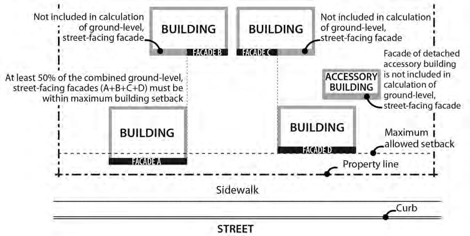
Figure 140-4
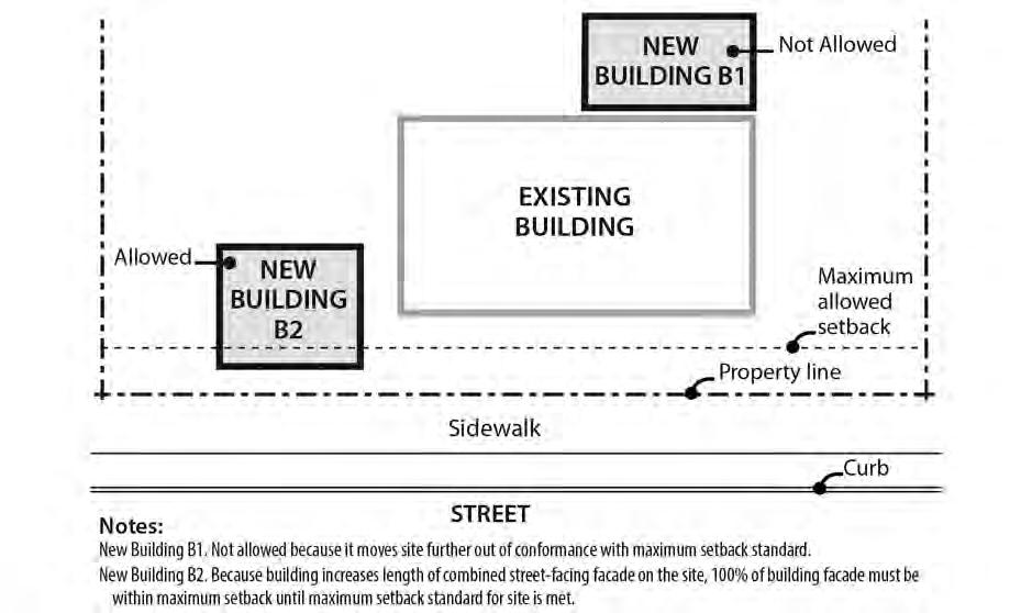
New Buildings on Sites with Buildings That Do Not Meet the Maximum Building Setback
D. Alternative maximum setback option for large retailers.
1. Purpose. The intent of these regulations is to allow deeper street setbacks for very large retail stores locating along transit streets or in Pedestrian Districts in exchange
for a pedestrian and transit-friendly main street type of development. These large retail sites can still be transit-supportive and pedestrian-friendly by placing smaller commercial buildings close to the street and by creating an internal circulation system that is similar to streets to separate the parking area into blocks. The intent is to encourage development that will, over time, form a pedestrian-friendly main street along the perimeter of the parking blocks and provide connectivity within the site and to adjacent streets and uses.
2. Regulation. Sites with a building having at least 100,000 square feet of floor area in Retail Sales And Service uses are exempt from the maximum setback requirement of Table 140-2 and the vehicle area frontage limitations of 33.266.130.C.3 if all of the requirements of this paragraph are met. For sites with frontage on more than one transit street or more than one street in a Pedestrian District, this exemption may be used only along one transit street frontage or frontage along a street in a Pedestrian District.
a. Other buildings on the site have ground level walls within the maximum setback for at least 25 percent of the frontage on a transit street or street in a Pedestrian District. These buildings must be constructed before or at the same time as the large retail store;
b. Internal circulation system. An internal circulation system that meets the following standards must be provided.
(1) Internal accessways that are similar to streets must divide the site into parking areas that are no greater than 55,000 square feet;
(2) These accessways must connect to the transit street, or street in a Pedestrian District, at least every 250 feet;
(3) Each internal accessway must have at least one auto travel lane, curbs, and unobstructed sidewalks on both sides. One of the following must be met:
• The sidewalks must be at least 10 feet wide and planted with trees a maximum of 30 feet on center. Trees must be planted in the center of unpaved tree wells at least 18 square feet, with a minimum dimension of 3 feet. The unpaved area may be covered with a tree grate. Tree wells must be adjacent to the curb, and must be located so there is at least 6 feet of unobstructed sidewalk; or
• The sidewalks must be at least 6 feet wide. There must be a planting strip at least 4 feet wide. The planting strip must be between the curb and the sidewalk, and be landscaped to at least the L1 standard except that trees cannot be grouped.
(4) Along each internal accessway that intersects a transit street, parking must be provided between both sidewalks and the auto travel lanes except for within 75 feet of the transit street intersection, measured from the street lot line, where parking is not allowed;
(5) Curb extensions that are at least the full depth of the parking must be provided, as shown in Figure 140-5, at the intersections of internal accessways that have parking; and
Chapter 33.140 Title 33, Planning and Zoning
(6) The internal accessways are excluded from the portion of the parking and loading area used to calculate required interior landscaping.
c. Connections between sites. This standard applies to all commercial, office, or institutional development that is adjacent to sites either developed for commercial, office, or institutional use, or zoned C, E, or I. The system must connect the buildings on the site to these adjacent sites.
Internal Circulation System

33.140.220 Building Coverage
A. Purpose. The building coverage standards work with the FAR, height, and setback standards to control the overall bulk of structures. The standards assure that taller buildings will not have such a large footprint that their total bulk will overwhelm adjacent development or be inconsistent with the desired character of the zone. In the EG1, EG2,
Figure 140-5
Title 33, Planning and Zoning
and IG2 zones, the standards work to assure that buildings will not dominate areas they are in. There is no limit to building coverage in the EX and IG1 zones because of the existing built-up character of the zones. There is no limit in the IH zone because the zone is designed to provide development flexibility.
B. The building coverage standards. The maximum building coverage for a site is stated in Table 140-2. The building coverage limits apply to all buildings and covered structures.
33.140.225 Landscaped Areas
A. Purpose. Landscaping is required to help soften the effects of built and paved areas. Landscaping also helps cool the air temperature, intercept rainfall and reduce stormwater runoff by providing non-paved permeable surface. Landscaping can also provide food for people and habitat for birds and other wildlife. Landscaping is required for all employment and industrially zoned lands abutting R-zoned lands to provide buffering and promote the livability of the residential lands.
B. Minimum landscaped area standard. The required amounts of landscaped areas are stated in Table 140-2. Required landscaped areas must be at ground level and comply with at least the L1 standard as stated in Chapter 33.248, Landscaping and Screening. However, up to one-third of the required landscaped area may be improved for active or passive recreational use, or for use by pedestrians. Examples include walkways, play areas, plazas, picnic areas, and unenclosed recreational facilities. Any required landscaping, such as for required setbacks or parking lots, applies towards the landscaped area standard.
33.140.227
Trees
Requirements for street trees and for on-site tree preservation, protection, and overall tree density are in Title 11, Trees. See Chapter 11.50, Trees in Development Situations.
33.140.230
Windows in the EX Zone
A. Windows in street-facing facades.
1. Purpose. In the EX zone, this standard:
• Ensures that there is a visual connection between activities occurring within a structure and the street;
• Enhances public safety by allowing people to survey their neighborhood from inside a structure; and
• Provides a more pleasant pedestrian environment by preventing large expanses of blank facades along streets.
2. Where this standard applies. This standard applies to street-facing facades of buildings in the EX zone. Where a proposal is for an alteration or addition to existing development, the applicant may choose to apply the standard either to the portion being altered or added, or to the entire street-facing facade.
3. Windows in street-facing facades. At least 15 percent of the area of each facade that faces a street lot line must be windows or main entrance doors. Windows used to meet this standard must allow views from the building to the street. Glass block does not meet this standard. Windows in garage doors do not count toward meeting this
standard, but windows in garage walls do count toward meeting this standard. To count toward meeting this standard a door must be at the main entrance and face the street lot line. For structures subject to ground floor window requirements, windows used to meet ground floor window requirements may also be used to meet this standard.
4. Exemption. Development on flag lots or on lots that slope up or down from the street with an average slope of 20 percent or more are exempt from this standard.
B. Ground floor windows.
1. Purpose. In the EX zone, blank walls on the ground level of buildings are limited in order to:
• Provide a pleasant, rich, and diverse pedestrian experience by connecting activities occurring within a structure to adjacent sidewalk areas, or allowing public art at the ground level;
• Encourage continuity of retail and service uses;
• Encourage surveillance opportunities by restricting fortress-like facades at street level; and
• Avoid a monotonous pedestrian environment.
2. Required amounts of window area. In the EX zone, all exterior walls on the ground level that are 20 feet or closer to a street lot line, sidewalk, plaza, or other public open space or right-of-way must have windows. The windows must be at least 50 percent of the length and 25 percent of the ground level wall area. For the purposes of this standard, ground level wall areas include all exterior wall areas from 2 feet to 10 feet above the finished grade. The requirement does not apply to the walls of residential units, and does not apply to the walls of parking structures when set back at least 5 feet and landscaped to at least the L2 standard.
3. Qualifying window features. Required window areas must be either windows that allow views into working areas or lobbies, pedestrian entrances, or display windows set into the wall. Display cases attached to the outside wall do not qualify. The bottom of the windows must be no more than 4 feet above the adjacent exterior grade.
4. Exceptions for Public Arts. Outside of the Central City plan district, public art is allowed instead of meeting the ground floor window provision. Covenants for the public art will be required, following the regulations of Section 33.700.060, Covenants with the City, to ensure the installation, preservation, maintenance, and replacement of the public art. To qualify for this exception, documentation of approval by the City Arts Program or its designee must be provided prior to approval of the building permit.
33.140.235 Screening
A. Purpose. The screening standards address specific unsightly features which detract from the appearance of an area.
B. Garbage and recycling collection areas. In all zones except the IH zone, exterior garbage cans, garbage collection areas, and recycling collection areas must be screened from the
street and any adjacent properties. Screening must comply with at least the L3 or F2 standards of Chapter 33.248, Landscaping and Screening.
C. Mechanical equipment. Mechanical equipment located on the ground, such as heating or cooling equipment, pumps, or generators, must be screened from the street and any abutting residential zones by walls, fences, or vegetation. Screening must comply with at least the L2 or F2 standards of Chapter 33.248, Landscaping and Screening, and be tall enough to screen the equipment. Mechanical equipment placed on roofs must be screened in one of the following ways, if the equipment is within 50 feet of an R zone:
1. A parapet along facades facing the R zone that is as tall as the tallest part of the equipment;
2. A screen around the equipment that is as tall as the tallest part of the equipment; or
3. The equipment is set back from roof edges facing the R zone 3 feet for each foot of height of the equipment.
D. Other screening requirements. The screening requirements for parking, exterior storage, and exterior display areas are stated with the regulations for those types of development.
33.140.240 Pedestrian Standards
A. Purpose. The pedestrian standards encourage a safe, attractive, and usable pedestrian circulation system in developments in the employment zones. They ensure a direct pedestrian connection between abutting streets and buildings on the site, and between buildings and other activities within the site. In addition, they provide for connections between adjacent sites, where feasible.
B. The standards. The standards of this section apply to all development in the EG1, EG2, and EX zones except houses, attached houses, and duplexes. An on-site pedestrian circulation system must be provided. The system must meet all standards of this subsection.
1. Connections. The on-site pedestrian circulation system must provide connections as specified below:
a. Connection between streets and entrances.
(1) Sites with one street frontage. Generally. There must be a connection between one main entrance of each building on the site and the adjacent street. The connection may not be more than 20 feet longer or 120 percent of the straight line distance, whichever is less.
• Household Living. Sites where all of the floor area is in Household Living uses are only required to provide a connection to one main entrance on the site. The connection may not be more than 20 feet longer or 120 percent of the straight line distance, whichever is less.
• Tree preservation. If a tree that is at least 12 inches in diameter is proposed for preservation, and the location of the tree or its root protection zone would prevent the standard of this paragraph from
being met, the connection may be up to 200 percent of the straight line distance.
(2) Sites with more than one street frontage. Where the site has more than one street frontage, the following must be met:
• The standard of B.1.a(1) must be met to connect the main entrance of each building on the site to the closest sidewalk or roadway if there are no sidewalks. Sites where all of the floor area is in Household Living uses are only required to provide a connection meeting the standard of B.1.a(1) to one main entrance on the site;
• An additional connection, which does not have to be a straight line connection, is required between each of the other streets and a pedestrian entrance. However, if at least 50 percent of a street facing facade is within 10 feet of the street, no connection is required to that street.
b. Internal connections. The system must connect all main entrances on the site, and provide connections to other areas of the site, such as parking areas, bicycle parking, recreational areas, common outdoor areas, and any pedestrian amenities.
2. Materials.
a. The circulation system must be hard-surfaced, and be at least 6 feet wide.
b. Where the system crosses driveways, parking areas, and loading areas, the system must be clearly identifiable, through the use of elevation changes, speed bumps, a different paving material, or other similar method. Striping does not meet this requirement. Elevation changes and speed bumps must be at least 4 inches high.
c. Where the system is parallel and adjacent to an auto travel lane, the system must be a raised path or be separated from the auto travel lane by a raised curb, bollards, landscaping or other physical barrier. If a raised path is used it must be at least 4 inches high and the ends of the raised portions must be equipped with curb ramps. Bollard spacing must be no further apart than 5 feet on center.
3. Lighting. The on-site pedestrian circulation system must be lighted to a level where the system can be used at night by the employees, residents, and customers.
4. EG1 and EX zones. The land between a building and a street lot line must be landscaped to at least the L1 level and/or hard-surfaced for use by pedestrians. This area may be counted towards any minimum landscaped area requirements. Vehicle areas and exterior display, storage, and work activities, if allowed, are exempt from this standard. Bicycle parking may be located in the area between a building and a street lot line when the area is hard-surfaced.
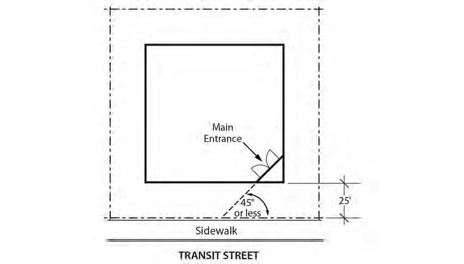
33.140.242 Transit Street Main Entrance
A. Purpose. Locating the main entrance to a use on a transit street provides convenient pedestrian access between the use and public sidewalks and transit facilities, and so promotes walking and the use of transit.
Title 33, Planning and Zoning
B. Applicability.
1. Generally. In the EX and EG1 zones, all sites with at least one frontage on a transit street, and where any of the floor area on the site is in nonresidential uses, must meet the following standards for the nonresidential uses. If the site has frontage on more than one transit street, the standards of Subsection C, below, must be met on at least one of the transit streets;
2. Small housing types. Houses, attached houses, manufactured homes, duplexes, attached duplexes, triplexes, and fourplexes must meet the standards of subsection 33.140.265.D, Residential Main Entrance, instead of the requirements of this section.
C. Location. For the portion of buildings that conform to the maximum building setback, at least one main entrance for each nonresidential tenant space on the ground floor must meet the standards of this section. The ground floor is the lowest floor of the building that is within four feet of the adjacent transit street grade. The main entrance must:
1. Be within 25 feet of the transit street;
2. Allow pedestrians to both enter and exit the building; and
3. Either:
a. Face the transit street; or
b. Be at an angle of up to 45 degrees from the transit street, measured from the street property line, as shown in Figure 140-6.
D. Unlocked during regular business hours. The main entrance that meets the standards of Subsection C must be unlocked during regular business hours.
Chapter 33.140
140-6
Transit Street Main Entrance
33.140.245 Exterior Display, Storage, and Work Activities
A. Purpose. The exterior development standards of this section are intended to assure that exterior display, storage, and work activities:
• Will be consistent with the desired character of the zone;
• Will not be a detriment to the overall appearance of an employment or industrial area, and exterior activities in the EG1 zone will be limited to a similar level as exterior activities in the Commercial Employment zone;
• Will not have adverse impacts on adjacent properties, especially those zoned residential; and
• Will not have an adverse impact on the environment.
B. Exterior display.
1. Employment zones. Exterior display of goods is allowed as follows. The setback and landscaping standards for exterior display areas are stated in Table 140-4:
a. Exterior display of goods is allowed in the EG1 zone except for uses in the Industrial categories. Exterior display of goods is not allowed for uses in the Industrial categories in the EG1 zone.
b. Exterior display of goods is allowed in the EG2 zone.
c. Exterior display of goods is allowed in the EX zone except for the display of motor vehicles, recreational vehicles, motor vehicle parts and supplies, building materials, and goods associated with an industrial use.
Figure
Title 33, Planning and Zoning
2. Industrial zones. Exterior display of goods is allowed in the I zones. The setback and landscaping standards for exterior display areas are stated in Table 140-4.
C. Exterior storage.
1. Employment zones. Exterior storage is allowed in the EG1 zones but is limited to 20 percent of the site area for all uses except lumber yards and other building material stores. Exterior storage is allowed in the EG2 zones. Exterior storage is not allowed in the EX zones. The setback and landscaping standards for exterior storage areas are stated in Table 140-4.
2. Industrial zones. Exterior storage is allowed in the I zones. The setback and landscaping standards for exterior storage areas area stated in Table 140-4.
D. Exterior work activities. Exterior work activities are allowed in the industrial zones but not the employment zones. The setback and landscaping standards for exterior activity areas are stated in Table 140-4.
E. Other exterior activities. Outdoor eating areas are allowed as an exterior activity in the employment and industrial zones.
F. Paving. All exterior development areas in the EG1, EX, and IG1 zones must be paved.
Table 140-4
Exterior Development Setbacks and Landscaping [1]
EG1, IG1 EG2, IG2
Exterior Display
Abutting a street 5 ft. / L1 10 ft. / L1
Abutting a C, E, I, CI or IR zone lot 0 0
Abutting an R or OS zone lot
Exterior Storage
/ L3
/
/ L1
/ L3
/ L3
Abutting a street [2, 3] 5 ft. / L3, or 5 ft./ F2 + L2 25 ft. / L3, or 25 ft. / F2 + L2 Not Allowed 5 ft. / L3, or 5 ft./ F2 + L2
Abutting a C, E, I, CI or IR zone lot 0 / F1 0 / F1 Not Allowed 0
Abutting an R or OS zone lot 5 ft. / L4, or 10 ft. / L3 10 ft. / L4, or 25 ft. / L3
Exterior Work Activities
Abutting a street [2, 3] Not allowed in EG1; 5 ft. / L3, or 5 ft./ F2 + L2 in IG1
Abutting a C, E, I, CI or IR zone lot
Abutting an R zone lot
Not allowed in EG1; 0 / F1 in IG1
Not allowed in EG1; 5 ft. / L4, or 10 ft. / L3 in IG1
Not allowed in EG2; 25 ft. / L3, or 25 ft. / F2 + L2 in IG2
Not allowed in EG2; 0 / F1 in IG2
Not allowed in EG2; 25 ft. / L3 or 25 ft. / F2 + L2 in IG2
Allowed 10 ft. / L4, or 25 ft. / L3
Not Allowed 5 ft. / L3, or 5 ft./ F2 + L2
Not Allowed 0
Not Allowed 25 ft. / L3
Notes:
[1] The development standards first state the required setback, then the required landscaping standard.
[2] If parking areas are placed between exterior storage areas and the street, an F2 screen only is required on the edge of the storage area.
[3] When the F2 + L2 option is used, the fence must be placed along the interior side of the landscaped area.
33.140.250 Trucks and Equipment
The regulations for truck and equipment parking apply to business vehicles that are parked regularly at a site. The regulations do not apply to pick-up and delivery activities, or to the use of vehicles during construction, or other service at the site which occurs on an intermittent and short-term basis. The truck categories are defined in Chapter 33.910.
A. Light and medium trucks. The parking of light and medium trucks and similar equipment is allowed in areas that meet the perimeter development standards for parking areas. The areas must be paved.
Title 33, Planning and Zoning
3/1/25
B. Heavy trucks. The parking of heavy trucks and similar equipment is allowed in zones that allow exterior storage. The development standards for exterior storage must be met in the area where the heavy trucks and similar equipment are parked.
33.140.255 Drive-Through Facilities
Drive-through facilities are allowed in the zones which are intended for auto- accommodating development. They are not consistent with or supportive of areas where the desired character is pedestrian-oriented development. The standards for drive-through facilities are stated in Chapter 33.224, Drive-Through Facilities.
A. EG and I zones. Drive-through facilities are allowed in the EG and I zones.
B. EX zone. Drive-through facilities are prohibited in the EX zone.
33.140.265 Residential Development
When allowed, residential development is subject to the following development standards:
A. Generally. Except as specified in this section, base zone development standards continue to apply;
B. Existing buildings. Residential uses in existing buildings have no density limit within the building;
C. New development. Residential uses in new development are subject to the development standards of the EX zone, except as specified in this section;
D. Residential main entrance.
1. Purpose. The main entrance standards serve several purposes:
• The main entrance standards, together with the window and garage standards ensure that there is a physical and visual connection between the living area of the residence and the street;
• They enhance public safety for residents and visitors and provide opportunities for community interaction;
• They ensure that the pedestrian entrance is visible or clearly identifiable from the street by its orientation or articulation; and
• They ensure that pedestrians can easily find the main entrance, and so establish how to enter the residence.
• Ensure a connection to the public realm for development on lots fronting both private and public streets by making the pedestrian entrance visible or clearly identifiable from the public street.
2. Where these standards apply.
a. The standards of this subsection apply to houses, attached houses, manufactured homes, duplexes, attached duplexes, triplexes, and fourplexes in the employment and industrial zones.
b. Where a proposal is for an alteration or addition to existing development, the standards of this section apply only to the portion being altered or added.
c. On sites with frontage on both a private street and a public street, the standards apply to the site frontage on the public street. On all other sites with more than one street frontage, the applicant may choose on which frontage to meet the standards.
d. Development on flag lots or on lots which slope up or down from the street with an average slope of 20 percent or more are exempt from these standards.
3. Location. At least one main entrance for each strucutre must:
a. Be within 8 feet of the longest street-facing wall of the structure; and
b. Either:
(1) Face the street. See Figure 140-7;
(2) Be at an angle of up to 45 degrees from the street; or
(3) Open onto a porch. See Figure 140-8. The porch must:
• Be at least 25 square feet in area;
• Have at least one entrance facing the street; and
• Have a roof that is:
No more than 12 feet above the floor of the porch; and
At least 30 percent solid. This standard may be met by having 30 percent of the porch area covered with a solid roof, or by having the entire area covered with lattice or other open material if no more than 70 percent of the area of the material is open.
4. Duplexes on corner lots. Where a duplex is on a corner lot, the requirements of Paragraph C.3, above, must be met for both dwelling units. Both main entrances may face the same street.
E. Street-facing facades.
1. Purpose. The standard:
• Together with the main entrance and garage standards, ensures that there is a visual connection between the living area of the residence and the street;
• Enhances public safety by allowing people to survey their neighborhood from inside their residences; and
• Provides a more pleasant pedestrian environment by preventing large expanses of blank facades along streets.
2. Where this standard applies. The standard of this subsection applies to houses, attached houses, manufactured homes, duplexes, attached duplexes, triplexes, and fourplexes in the Employment and Industrial zones. Where a proposal is for an alteration or addition to existing development, the applicant may choose to apply the standard either to the portion being altered or added, or to the entire street-facing
Planning and Zoning
facade. Development on flag lots or on lots that slope up or down from the street with an average slope of 20 percent or more are exempt from this standard.
3. The standard. At least 15 percent of the area of each facade that faces a street lot line must be windows or main entrance doors. Windows used to meet this standard must allow views from the building to the street. Glass block does not meet this standard. Windows in garage doors do not count toward meeting this standard, but windows in garage walls do count toward meeting this standard. To count toward meeting this standard, a door must be at the main entrance and facing a street lot line.
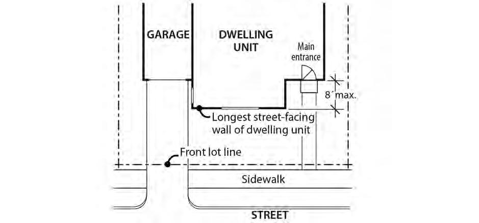
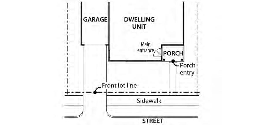
Figure 140-7
Main Entrance Facing the Street
Figure 140-8
Main Entrance Opening Onto a Porch
F. Garages.
1. Purpose. These standards:
• Together with the window and main entrance standards, ensure that there is a physical and visual connection between the living area of the residence and the street;
• Ensure that the location and amount of the living area of the residence, as seen from the street, is more prominent than the garage;
• Prevent garages from obscuring the main entrance from the street and ensure that the main entrance for pedestrians, rather than automobiles, is the prominent entrance;
• Provide for a more pleasant pedestrian environment by preventing garages and vehicle areas from dominating the views of the neighborhood from the sidewalk; and
• Enhance public safety by preventing garages from blocking views of the street from inside the residence.
2. Where these standards apply. The requirements of Paragraphs F.3 and F.4, below, apply to houses, attached houses, manufactured homes, duplexes, attached duplexes, triplexes, and fourplexes. When a proposal is for an alteration or addition to existing development, the standards of this section apply only to the portion being altered or added. Development on flag lots or on lots which slope up or down from the street with an average slope of 20 percent or more are exempt from these standards.
3. Length of street-facing garage wall. The length of the garage wall facing the street may be up to 50 percent of the length of the street-facing building facade. See Figure 1409. For attached houses and attached duplexes, the standard applies to the combined length of the street-facing facades of the attached units.
4. Street lot line setbacks.
a. Generally. A garage wall that faces a street may be no closer to the street lot line than the longest street-facing wall of the dwelling unit. See Figure 140-11.
b. Exception. A street-facing garage wall may be up to 6 feet in front of the longest street-facing wall of the dwelling unit, if:
(1) The street-facing garage wall is 40 percent or less of the length of the building facade; and
(2) There is a porch at the main entrance. The garage wall may not be closer to the street lot line than the front of the porch. See Figure 140-12. The porch must meet the following:
• The porch must be at least 48 square feet in area and have minimum dimensions of 6 feet by 6 feet;
• The porch must have a solid roof; and
• The roof may not be more than 12 feet above the floor of the porch.
Title 33, Planning and Zoning
c. Exemption. Where a lot has more than one street lot line, and there is an existing dwelling unit on the lot, this standard must be met only on the street-facing facade on which the main entrance is located.
33.140.270 Detached Accessory Structures
A. Purpose. These standards are intended to maintain separation and privacy to abutting residential lots from nonresidential development.
B. General standards.
1. The regulations of this section apply to detached accessory structures on sites with non-residential uses. For sites where all of the floor area is in residential use, detached accessory structures are subject to the standards of Section 33.120.280. Detached garages that are accessory to residential development are also subject to the standards of 33.140.265, Residential Development.
2. Unless stated in this section, the height and building coverage standards of the base zone apply to detached accessory structures.
C. Setbacks.
1. Uncovered accessory structures. Uncovered accessory structures, such as flag poles, lamp posts, signs, antennas and dishes, mechanical equipment, uncovered decks, play structures, and tennis courts, are allowed in a street setback, but not in a required setback from an abutting residential zone.
2. Covered structures.
a. Covered structures, such as storage buildings, greenhouses, work shed, covered decks, and covered recreational structures, are subject to the setbacks for buildings.
b. Water cisterns that are 6 feet or less in height are allowed in side and rear setbacks, including setbacks abutting a residential zone.
c. See Section 33.140.265, Residential Development, for additional requirements for garages that are accessory to residential development.
Chapter
Figure 140-9
Length of Street-Facing Garage Wall
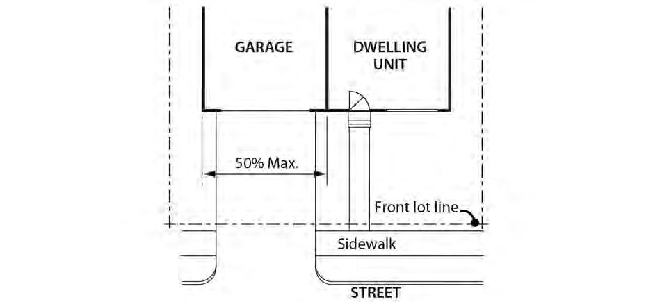
Figure 140-10
Length of Street-Facing Garage Wall Exception
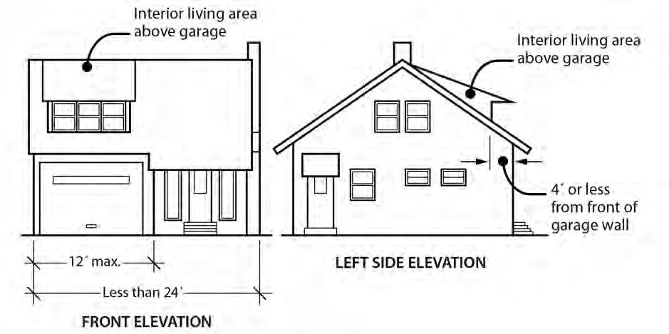
Title 33, Planning and Zoning
3/1/25
Figure 140-11
Street Lot Line Setback
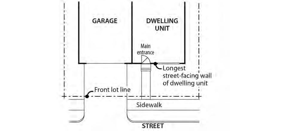
Figure 140-12
Garage Front Setback Exception
33.140.275 Fences
A. Purpose. The fence regulations promote the positive benefits of fences without negatively impacting the community or endangering public or vehicle safety. Fences near streets are kept low in order to allow visibility into and out of the site and to ensure visibility for motorists. Fences in any required side or rear setback are limited in height so as to not conflict with the purpose for the setback.
Chapter 33.140 Title 33, Planning and Zoning
B. Types of fences. The standards apply to walls, fences, and screens of all types whether open, solid, wood, metal, wire, masonry, or other material.
C. Location and heights.
1. Fences along street lot lines, including pedestrian connections.
a. EG1, IG1 and IH zones. In EG1, IG1, and IH zones, fences up to 3-1/2 feet high are allowed in a required street building setback, including setbacks from pedestrian connections.
b. EG2, EX and IG2 zones. In EG2, EX and IG2 zones, within 10 feet of a street lot line, fences that meet the following standards are allowed:
(1) Fences that are more than 50 percent sight-obscuring may be up to 3-1/2 feet high;
(2) Fences that are 50 percent or less sight-obscuring may be up to 8 feet high.
c. EG2 and IG2 zones. In EG2 and IG2 zones, fences that are more than 50 percent sight-obscuring may be up to 8 feet high within the street building setback if they are more than 10 feet from the lot line
2. Fences along other lot lines. Fences up to 8 feet high are allowed in required building setbacks along all other lot lines.
3. Fences in all other locations. The height for fences in locations other than described in Paragraphs C.1 and 2 is the same as the regular height limits of the zone.
D. Reference to other regulations. Electrified fences are regulated under Title 26, Electrical Regulations. The use of barbed wire is regulated under Title 24, Building Regulations
33.140.280 Demolitions
A. Generally. Demolition on a site that requires a demolition permit is subject to the tree preservation and protection requirements of Title 11, Trees. See Chapter 11.50, Trees in Development Situations.
B. Historic resources. Demolitions of historic resources is regulated by Chapter 33.445, Historic Resource Overlay Zone.
33.140.290 Nonconforming Development
Existing development that does not conform to the development standards of this chapter may be subject to the regulations of Chapter 33.258, Nonconforming Situations.
33.140.295 Parking and Loading
The regulations for vehicle parking, bicycle parking, loading, and transportation and parking demand management are stated in Chapter 33.266, Parking, Loading, and Transportation and Parking Demand Management.
33.140.300 Signs
The sign regulations are stated in Title 32, Signs and Related Regulations.
Title 33, Planning and Zoning Chapter 33.140 3/1/25 Employment and Industrial Zones
33.140.310 Superblock Requirements
Developments in the EX zone which are on land that includes vacated rights-of-way may be subject to the superblock standards of Chapter 33.293, Superblocks.
33.140.315 Recycling Areas
Requirements for recycling areas are regulated by the Bureau of Planning and Sustainability. See Section 17.102.270, Businesses and Multifamily Complexes Required to Recycle, of the Portland City Code.
33.140.320 Inclusionary Housing
The standards pertaining to inclusionary housing are stated in Chapter 33.245, Inclusionary Housing.
(Amended by: Ord. No. 165376, effective 5/29/92; Ord. No. 165594, effective 7/8/92; Ord. No. 166920, effective 10/1/93; Ord. No. 167186, effective 12/31/93; Ord. No. 167189, effective 1/14/94; Ord. No. 169535, effective 1/8/96; Ord. No. 169987, effective 7/1/96; Ord. No. 170704, effective 1/1/97; Ord. No. 171219, effective 7/1/97; Ord. No. 171718, effective 11/29/97; Ord. No. 173259, effective 5/14/99; Ord. No. 173593, effective 9/3/99; Ord. No. 173729, effective 9/8/99; Ord. No. 174263, effective 4/15/00; Ord. No. 174980, effective 11/20/00; Ord. No. 175204, effective 3/1/01; Ord. No. 175837, effective 9/7/01; Ord. No. 175966, effective 10/26/01; Ord Nos. 175965 and 176333, effective 7/1/02; Ord. No. 176469, effective 7/1/02; Ord. No. 177028, effective 12/14/02; Ord. No. 177422, effective 6/7/03; Ord. No. 177404, effective 7/1/03; Ord. No. 178172, effective 3/5/04; Ord. No. 178509, effective 7/16/04; Ord. No. 178832, effective 10/21/04; Ord. Nos. 179980 and 179994, effective 4/22/06; Ord. No. 180619, effective 12/22/06; Ord. No. 181357, effective 11/9/07; Ord. No. 182429, effective 1/16/09; Ord. No. 183598, effective 4/24/10; Ord. No. 184524, effective 7/1/11; Ord. No. 185412, effective 6/13/12; Ord. No. 185915, effective 5/1/13; Ord. No. 185974, effective 5/10/13; Ord. No. 186639, effective 7/11/14; Ord. No. 186053, effective 1/1/15; Ord. No. 187216, effective 7/24/15; Ord. No. 187471, effective 1/1/16; Ord. No. 188077, effective 12/9/16; Ord. No. 188142, effective 1/13/17; Ord. No 188162, effective 2/1/17; Ord. No. 188177, effective 5/24/18; Ord. No. 188958, effective 5/24/18; Ord. No. 189000, effective 7/9/18; Ord. No. 189488, effective 12/2/19; Ord. No. 189807, effective 12/18/19; Ord. No. 189805, effective 3/1/20; Ord. No. 190023, effective 8/10/20; Ord. No. 190380, effective 4/30/21 and 8/1/21; Ord. No. 190687, effective 3/1/22; Ord. No. 190978, effective 8/31/22; Ord. No. 191079, effective 3/31/23; Ord. No. 191310, effective 6/30/23; Ord. No. 191609, effective 3/1/24; Ord. No. 191779, effective 10/1/24; Ord. No. 191961, effective 3/1/25.)
Chapter
Title 33, Planning and Zoning
33.471 Prime Industrial Overlay Zone
Sections: General
33.471.010 Purpose
33.471.020 Map Symbol
33.471.030 Applying the Prime Industrial Overlay Zone
33.471.040 Initiating a Quasi-judicial Comprehensive Plan Map Amendment Use Regulations
33.471.050 Self-Service Storage
33.471.060 Commercial Outdoor Recreation
33.471.070 Major Event Entertainment
33.471.080 Parks and Open Areas Uses
33.471.010 Purpose
General
The purposes of the Prime Industrial overlay zone are to protect land that has been identified in the Comprehensive Plan as Prime Industrial, and to prioritize these areas for long-term retention. Prime Industrial Land is suited for traded-sector and supportive industries and possesses characteristics that are difficult to replace in the region. In Portland, Prime Industrial land consists of the Portland Harbor, Columbia Corridor, and Brooklyn Yard industrial districts. These freight-hub districts include Oregon’s largest seaport, rail hub, and airport. Existing and potential multimodal freight access in these districts support interregional transport, exporting industries, and associated industrial businesses and activities. The regulations protect these areas by preventing, or requiring an off-set for, conversion of the land to another zone or use that would reduce industrial development capacity.
33.471.020 Map Symbol
The Prime Industrial overlay zone is shown on the Official Zoning Maps with the “k” symbol.
33.471.030 Applying the Prime Industrial overlay zone
The Prime Industrial overlay zone is to be applied to all land designated as Prime Industrial in the Comprehensive Plan except for land that is zoned Open Space
33.471.040 Initiating a Quasi-judicial Comprehensive Plan Map amendment. In the Prime Industrial overlay zone, an applicant is prohibited from initiating a quasi-judicial Comprehensive Plan Map amendment unless the amendment is from Mixed Employment to Industrial Sanctuary.
Use Regulations
33.471.050 Self-Service Storage
Self-Service Storage is prohibited in the Prime Industrial overlay zone.
Chapter 33.471 Title 33, Planning and Zoning
Prime Industrial Overlay Zone 5/24/18
33.471.060 Commercial Outdoor Recreation
In the I and EG zones, Commercial Outdoor Recreation uses are limited to 20,000 square feet. More than 20,000 square feet in Commercial Outdoor Recreation use on a site is prohibited.
33.471.070 Major Event Entertainment
Major Event Entertainment is prohibited in the Prime Industrial overlay zone.
33.471.080 Parks and Open Areas
Parks and Open Areas are prohibited in the Prime Industrial overlay zone except for the following:
A. Parks and Open Areas that are 2 acres or less in size are allowed;
B. Nature preserves are allowed;
C. Recreational trails and boat launching areas are allowed. Trailheads, parking areas, bathroom facilities, educational kiosks and other development or facilities that are accessory to a recreational trail and boat launching areas are limited to 2 acres per site; and
D. Off-site mitigation is allowed if the mitigation is for impacts that occur in the Prime Industrial overlay zone.
(Adopted by: Ord. No. 188177, effective 5/24/18. Amended by: Ord. No. 188958, effective 5/24/18.)
33.430 Environmental Zones
Sections: General
33.430.010 Purpose
33.430.015 Purpose of the Environmental Protection Zone
33.430.017 Purpose of the Environmental Conservation Zone
33.430.020 Environmental Reports
33.430.030 Relationship to Other Environmental Regulations
33.430.033 Relationship to Scenic Resources Zone
33.430.035 Other City Regulations
33.430.040 Overlay Zones and Map Symbols
33.430.050 Subareas of Environmental Zones
33.430.060 Where These Regulations Apply
33.430.070 When These Regulations Apply
33.430.080 Items Exempt From These Regulations
33.430.090 Prohibitions
Development Standards
33.430.110 Purpose
33.430.120 Procedure
33.430.130 Permit Application Requirements
33.430.140 General Development Standards
33.430.150 Standards for Utility Lines
33.430.155 Standards Septic Systems
33.430.160 Standards for Land Divisions and Planned Developments
33.430.165 Standards for Property Line Adjustments and Replats
33.430.170 Standards for Resource Enhancement Projects
33.430.175 Standards for Right-of-Way Improvements
33.430.180 Standards for Stormwater Outfalls
33.430.185 Standards for Certain Flood and Water Control Facilities
33.430.190 Standards for Public Trails
33.430.195 Standards for Tree Removal in the Scenic Resources Zone
Environmental Review
33.430.210 Purpose
33.430.220 When Review is Required
33.430.230 Procedure
33.430.240 Supplemental Application Requirements
33.430.250 Approval Criteria
33.430.260 Use of Performance Guarantees
33.430.270 Special Evaluation by a Trained Professional
33.430.280 Modification of Base Zone Development Standards
Natural Resource Management Plans
33.430.310 Purpose
33.430.320 Scope
33.430.330 Procedure
33.430.340 Components
33.430.350 Approval Criteria for Adoption and Amendment Corrections to Violations of This Chapter
33.430.400 Purpose
33.430.405 Correction Options
33.430.407 Recurring Violations of This Chapter Notice and Review Procedure
33.430.410 Purpose
33.430.420 When These Regulations Apply
33.430.430 Procedure
Map 430-1 Environmental Overlay Zone Map Correction Project Area
Map 430-2 Columbia Corridor Industrial and Environmental Mapping Project Area
Map 430-3 East Buttes, Terraces and Wetlands Conservation Plan Area
Map 430-4 Johnson Creek Basin Protection Plan Area
Map 430-5 Northwest Hills Natural Areas Protection Plan Area
Map 430-6 East Columbia Neighborhood Natural Resources Management Plan Area
Map 430-7 Peninsula One Natural Resources Management Plan Area
Map 430-8 Forest Park Natural Resources Management Plan Area
Map 430-9 Middle Columbia Corridor/Airport Natural Resources Inventory
Environmental Mapping Project Area
Map 430-10 Bank Reconfiguration and Basking Features Area
General
33.430.010 Purpose
Environmental zones protect resources and functional values that have been identified by the City as providing benefits to the public. The environmental regulations encourage flexibility and innovation in site planning and provide for development that is carefully designed to be sensitive to the site's protected resources. These regulations also help meet other City goals, along with other regional, state, and federal goals and regulations. The environmental regulations also carry out Comprehensive Plan policies and objectives.
33.430.015 Purpose of the Environmental Protection Zone
The Environmental Protection zone provides the highest level of protection to the most important resources and functional values. These resources and functional values are identified and assigned value in the inventory and economic, social, environmental, and energy (ESEE) analysis for each specific study area. Development will be approved in the environmental protection zone only in rare and unusual circumstances.
33.430.017
Purpose of the Environmental Conservation Zone
The Environmental Conservation zone conserves important resources and functional values in areas where the resources and functional values can be protected while allowing environmentally sensitive urban development.
33.430.020
Environmental Reports
The application of the environmental zones is based on detailed studies that have been carried out within six separate areas of the City. The City’s policy objectives for these study areas are described in reports. Each study identifies the natural resource features and describes the functional values within resource sites. Functional values are the benefits provided by resources. The values for each resource site are described in the inventory section of these reports. The City has adopted the following six environmental study reports:
• Environmental Overlay Zone Map Correction Project
• Columbia Corridor Industrial and Environmental Mapping Project
• East Buttes, Terraces and Wetlands Conservation Plan
• Johnson Creek Basin Protection Plan
• Northwest Hills Natural Areas Protection Plan
• Middle Columbia Corridor/Airport Economic, Social, Environmental and Energy (ESEE) Analysis
33.430.030
Relationship To Other Environmental Regulations
Some of the six study areas discussed under Section 33.430.020 impose additional environmental regulations in Plan Districts. These additional regulations either supplement or supersede the regulations of this Chapter. Paragraph 33.700.070.E describes the hierarchy of regulations within the Zoning Code.
Additionally, Natural Resource Management Plans may contain regulations that supersede or supplement the regulations of this chapter. Whenever natural resource management plan provisions conflict with other provisions of this chapter, the natural resource management plan provisions supersede. Non-conflicting provisions supplement the provisions of this chapter. Maps 430-6, 7, and 8 show Natural Resource Management Plan areas.
The following Plan Districts and Natural Resource Management Plans have additional regulations that may supersede or supplement the environmental regulations of Chapter 430:
• The Balch Creek Watershed (see Chapter 33.563, Northwest Hills Plan District)
• Cascade Station / Portland International Center Plan District (see Chapter 33.508, Cascade Station / Portland International Center [CS/PIC])
• The Columbia South Shore within the Columbia Corridor (see Chapter 33.515, Columbia South Shore Plan District)
• Johnson Creek Basin (see Chapter 33.537, Johnson Creek Basin Plan District)
• Northwest Hills Natural Areas (see Chapter 33.563, Northwest Hills Plan District)
• Skyline West Conservation Plan area (see Chapter 33.563, Northwest Hills Plan District)
• East Columbia Neighborhood Natural Resources Management Plan (separate document)
• Forest Park Natural Resources Management Plan (separate document)
• Natural Resources Management Plan for the Peninsula Drainage District No. 1 (separate document)
• Portland International Airport Plan District (see Chapter 33.565, Portland International Airport Plan District)
Chapter 33.430 Title 33, Planning and Zoning
This chapter contains only the City's environmental regulations. Activities which the City regulates through this chapter may also be regulated by other agencies. In cases of overlapping City, Special District, Regional, State, or Federal regulations, the more stringent regulations will control. City approval does not imply approval by other agencies.
33.430.033 Relationship to Scenic Resources
When an environmental zone has been applied at the location of a designated scenic resource, environmental review must include consideration of the scenic qualities of the resource as identified in the Scenic Resources Protection Plan, Central City Scenic Resources Protection Plan, or River Plan / South Reach Scenic Resources Protection Plan, and any relevant development standards of 33.480
33.430.035 Other City Regulations
Other City regulations such as Title 10, Erosion Control, and Title 11, Trees, may apply to sites in the environmental overlay zones.
33.430.040 Overlay Zones and Map Symbols
There are two environmental overlay zones.
A. The Environmental Protection overlay zone is applied wherever the City determines that highly significant resources and functional values are present. The Environmental Protection overlay zone is shown on the Official Zoning Maps with either the "p" symbol or a dark green color
B. The Environmental Conservation overlay zone is applied wherever the City determines that significant resources and functional values are present. The Environmental Conservation overlay zone is shown on the Official Zoning Maps with either the "c" symbol or a light green color.
33.430.050 Subareas of Environmental Zones
Environmental overlay zones contain resource areas and transition areas. Resource areas contain significant resources and functional values. Transition areas surround the resource areas. Resources and functional values within transition areas are not significant, but they provide a buffer for the significant resources and functional values within the resource area. The transition area is measured as the first 25 feet inward from an environmental zone boundary. The remaining area is the resource area. See Figure 430-1. The following are three exceptions:
A. Where part of an environmental zone boundary is also the City Limits or Urban Service Boundary, there is no transition area.
B. Where environmental zone boundaries are contained within other environmental zone boundaries, there is no transition area.
C. Where environmental zone boundaries abut other environmental zone boundaries, transition areas are only measured from the combined outer-most boundaries of the environmental zones.
Title 33, Planning and Zoning
Environmental Zone Subareas
33.430.060 Where These Regulations Apply
These regulations apply to all environmental zones, except those in the Columbia South Shore Plan District that are south of NE Marine Drive, those in the Cascade Station/Portland International Center Plan District, City-owned land within the Forest Park Natural Resources Management Plan area, and the Peninsula Drainage District No. 1 Natural Resources Management Plan area. See also Section 33.430.030, Relationship to Other Environmental Regulations
33.430.070 When These Regulations Apply
Unless exempted by Section 33.430.080, below, the regulations of this chapter apply to the following:
A. Development;
B. All land divisions, property line adjustments, and replats except for middle housing land divisions. The regulations of this chapter do apply to development proposed on a middle housing land division site;
C. Removing, cutting, mowing, clearing, burning, or poisoning native trees and plants listed in the Portland Plant List;
D. Planting or removing trees and plants listed on the Nuisance Plants List, and planting or removing non-native non-nuisance trees and plants;
E. Changing topography, grading, excavating, and filling;
F. Resource enhancement; and
G. Dedication and expansions of rights-of-way.
Figure 430-1
33.430.080 Items Exempt From These Regulations
The following items, unless prohibited by Section 33.430.090, below, are exempt from the regulations of this chapter. Other City regulations such as Title 10, Erosion Control, and Title 11, Trees, must still be met.
A. Change of ownership;
B. Temporary emergency procedures necessary for the protection of life, health, safety, or property;
C. Dedicating right-of-way to widen an existing right-of-way;
D. Existing development, operations, and improvements, including the following activities:
1. Maintenance, repair, and replacement of existing structures, exterior improvements, roads, public trails, public rest points, public view areas, public interpretative facilities, and utilities. Except for the replacement of structures associated with a Basic Utility use, replacement is not exempt within the combined flood hazard area. Replacement is also not exempt whenever coverage or utility size is increased;
2. Continued maintenance of existing gardens, pastures, lawns, and other planted areas, including the installation of new irrigation and drainage facilities, new erosion control features, and the installation of plants except those listed on the Nuisance Plants List. Change of crop type or farming technique on land currently in agricultural use. Pruning trees and shrubs within 10 feet of buildings and structures attached to buildings, such as decks, stairs, and carports;
3. Changes to existing disturbance areas to accommodate the following when plantings do not include plants on the Nuisance Plants List and no trees 6 or more inches in diameter are removed;
a. Gardens, including raised beds no greater than 2 feet in height, and play areas surfaced with grass, groundcover plants, bark chips, sand or gravel;
b. Accessory structures with a footprint no larger than 100 square feet that are not on a foundation or concrete pad; and
c. Septic systems.
4. Alterations to buildings that do not change the building footprint and do not require adjustments to site-related development standards;
5. Operation, maintenance, and repair of the following:
a. Irrigation systems;
b. Stormwater management systems;
c. Pumping stations; and
d. Erosion control and soil stabilization features;
6. Operation, maintenance, and repair of drainage facilities, flood control structures, and conveyance channels that are managed by Drainage Districts as defined in ORS 547, and where the activity is conducted or authorized by the Drainage District. This
exemption does not apply if dredge spoils are placed onto the top of banks of the drainageway, or onto portions of the environmental overlay zone above the ordinary high water mark. Operation, maintenance, and repair of drainage facilities include:
a. Dredging and channel cleaning below the ordinary high water mark and vegetative maintenance within the minimum floodway cross-section of drainageways;
b. Operation, maintenance, and repair of drainage district pump stations, water control structures, or levees;
c. Reconfiguring the cross-section of drainage channels below the ordinary high water mark, or changing the location of the low flow channel within a wider drainage channel; and
d. Stabilizing banks and restoring levees back to original condition and footprint;
7. Removing or pruning the following trees and plants:
a. Trees. The following trees may be removed or pruned if no development or other activities subject to the regulations of this chapter are proposed and all removal or pruning activities are surrounded or protected to prevent erosion and sediment from leaving the site or negatively impacting resources on the site. Permanent erosion control, such as replanting areas of bare soil must be installed after removal or pruning:
(1) Dead, dying, diseased, or dangerous trees, or portions of trees, when they pose an immediate danger as determined by the City Forester or an arborist. On sites 7,000 square feet or larger in area, all sections of wood more than 12 inches in diameter must remain or be placed in the resource area of the site on which they were cut or within a commonly-owned environmental resource tract. These sections of wood are not required to remain when:
• The site contains only transition area; or
• The City Forester authorizes removal of diseased wood because it will threaten the health of other trees;
(2) Non-native non-nuisance trees located outside of the combined flood hazard area, except in the IH, IG2 and EG2 zones where non-native nonnuisance trees and plants can be removed within and outside of the combined flood hazard area;
(3) Trees listed on the Nuisance Plants List;
(4) Trees or portions of trees that are located within 10 feet of an existing building or structure attached to a building, such as a deck, stairs, or carport. This exemption does not apply to tree removal within the combined flood hazard area unless the tree to be removed is located on a lot zoned IH, IG2 or EG2; or
(5) Trees or portions of trees that exceed the height restriction of a view corridor with special height restrictions designated in the Scenic Resources
Protection Plan, Central City Scenic Resources Protection Plan or River Plan / South Reach Scenic Resource Protection Plan.
b. Other plants. The following may be removed or pruned if removal or pruning activities are surrounded or protected to prevent erosion and sediment from leaving the site or negatively impacting resources on the site. Permanent erosion control, such as replanting areas of bare soil, must be installed after removal or pruning:
(1) Plants that exceed the height restrictions of a view corridor with special height restrictions designated in the Scenic Resources Protection Plan, Central City Scenic Resources Protection Plan or River Plan / South Reach Scenic Resources Protection Plan; or
(2) Plants that block signage along a public recreational trail, within a resource enhancement area, or required by a state or federal agency; or
(3) Non-native plants and plants listed on the Nuisance Plant List.
8. Pruning trees in accordance with Title 11 permit requirements;
9. Alterations to existing houseboats or replacing houseboats in existing slips;
10. Development over existing paved surfaces that are not within the combined flood hazard area and are over 50 feet from any identified wetland or water body; and
11. Land divisions, Property Line Adjustments, or replats where all properties are developed, no additional building sites are created and no additional development is proposed.
E. The following new development and improvements:
1. Planting of native vegetation listed on the Portland Plant List when planted with handheld equipment;
2. Public street and sidewalk improvements meeting all of the following:
a. Improvements must be within a public right-of-way used by truck or automobile traffic; and
b. Streets and sidewalks must not exceed the minimum width standards of the Bureau of Transportation Engineering.
3. Groundwater monitoring wells constructed to the standards of the Oregon Water Resources Department and water quality monitoring stations, where access is by foot only;
4. Utilities installed above or below developed portions of public rights-of-way;
5. Utility service using a single utility pole or where no more than 100 square feet of ground surface is disturbed outside of the top of bank of water bodies and where the disturbed area is restored to the pre-construction conditions;
6. Temporary site investigative work including soil tests, land surveys, groundwater and water quality monitoring stations when all of the following are met:
a. The work is conducted using hand-held equipment only;
b. The disturbance is temporary;
c. Disturbance areas are restored to pre-existing conditions; and
d. No native trees are removed and within the combined flood hazard area located outside of the IH, IG2 and EG2 zones, no non-native non-nuisance trees are removed.
7. Installation of temporary fencing to protect resource enhancement project planting areas, or to close off or control the use of illegal trails. The fence must be removed within 5 years;
8. Installation of signage as part of public recreational trail, as part of a resource enhancement project, or as required by a state or federal agency;
9. Additional disturbance within an existing cemetery when all of the following are met:
a. The disturbance is for soil removal for a burial plot;
b. No more than 10 cubic yards of soil is removed per burial plot;
c. The disturbance area is set back at least 5 feet from the resource area of the environmental protection zone; and
d. No native trees 6 inches or more in diameter are removed;
10 Additional disturbance for gardens, play areas surfaced with grass, groundcover plants, bark chips, sand or gravel, and septic systems when the added disturbance area meets all of the following:
a. The added disturbance area does not exceed 500 square feet;
b. The total disturbance area on the site does not exceed standards in Table 430-1;
c. Outside the combined flood hazard area, no native trees 6 or more inches in diameter are removed;
d. Within the combined flood hazard area, no native or non-native non-nuisance trees 6 or more inches in diameter are removed; and
e. The disturbance area is located at least 30 feet from the top of bank of a stream or drainage and at least 50 feet from the edge of a wetland.
11. Trails and fire breaks meeting all of the following:
a. The trails or fire break must be confined to a single ownership or be within a public trail easement;
b. Widths must not exceed 36 inches. For trails, stair width must not exceed 50 inches, and trail grade must not exceed 20 percent except for the portion of the trail containing stairs;
Chapter 33.430 Title 33, Planning and Zoning
c. Plant trimming must not exceed a height of 8 feet and a width of 6 feet as shown in Figure 430-2;
d. Outside the combined flood hazard area, no native trees 6 or more inches in diameter and no native shrubs larger than 5 feet tall may be removed;
e. Within the combined flood hazard area, no native or non-native non-nuisance trees 6 or more inches in diameter and no native shrubs larger than 5 feet tall may be removed;
f. The trails or fire break must not be paved; and
g. The trails or fire break must be at least 15 feet from the top of bank of all water bodies.
12. All land divisions with tentative plans, final plans, and recorded plats showing all of the following for every lot created or adjusted; and Property Line Adjustments and replats with plans showing all of the following for each lot adjusted:
Figure 430-2
Trail Vegetation Pruning and Maintenance Area
a. Building sites at least five feet from all resource areas. For the purpose of this subsection, “building site” means an area of any shape in which a square 40 feet by 40 feet will fit;
b. Public and private utilities (including water lines, sewer lines or drain fields, and stormwater disposal facilities) where none of these utilities are in a resource area; and
c. Streets, driveways, and parking areas where all pavement is at least ten feet from a resource area.
F. Hand removal of trash, provided that native vegetation is not removed or damaged.
33.430.090
Prohibitions
The following items are prohibited in all environmental zones. Prohibitions apply to both transition areas and resource areas:
A. The use, packaging, transportation, or storage of hazardous substances, except as follows:
1. Transportation of hazardous substances through environmental zones by rail or on designated truck routes is allowed; and
2. Use of consumer quantities of hazardous substances within environmental zones is allowed subject to the regulations of this Title. Consumer quantities of hazardous substances are packaged and distributed in a form intended or suitable for sale through retail sales outlets for consumption by individuals for purposes of personal care and household use.
B. The planting or propagation of any plant listed on the Nuisance Plants List;
C. Exterior work activities, unless in conjunction with a river-related or river-dependent use. See Chapter 33.910, Definitions; and
D. Dumping of yard debris or trash.
Development Standards
33.430.110
Purpose
These development standards are intended to:
A. Encourage sensitive development while minimizing impact on resources;
B. Provide clear limitations on disturbance within resource areas;
C. Ensure that new development and alterations to existing development are compatible with and preserve the resources and functional values protected by the environmental zones;
D. Provide clear planting and erosion control requirements within resource areas;
E. Buffer the resource area from the noise, fumes, lights, and motion of vehicular traffic associated with industrial, commercial, and multi-dwelling residential uses; and
F. Limit the impacts on resources and functional values resulting from construction of certain types of utilities.
33.430.120 Procedure
A. Generally. Compliance with the development standards of this chapter is required for all development in the environmental zones and is determined as part of the building permit or development permit application process. For proposals that cannot meet all of the standards, Environmental Review is required. Where a proposal can meet all the standards, the applicant may choose to go through the discretionary environmental review process, or to meet the objective standards of this chapter.
The development standards are Sections 33.430.140 through .195; Sections 33.430.150 through .195 address specific types or aspects of development, while 33 430.140 applies to proposals not covered by the more specific sections. A proposal may be subject to several sections. For example, construction of a house may be subject to the General Development Standards of 33.430.140, the standards of 33.430.150, Utilities, and the standards of 33.430.180, Stormwater Outfalls. If the proposal can meet the general standards and standards for utilities, but not those for a stormwater outfall, environmental review is required only for the stormwater outfall. To be eligible to use the development standards for an aspect of a proposal, all of the standards within the relevant section must be met.
B. Adjustments prohibited. Adjustments to these standards are prohibited. Proposals that do not meet all the standards within each relevant section require approval through environmental review described in Sections 33.430.210 through .280.
33.430.130 Permit Application Requirements
A building permit or development permit application that is reviewed for compliance with the standards of this chapter requires more information than a permit not affected by these provisions. The information in Subsections A and B must be submitted with permit application plans Submission of the information in Subsection C is optional.
A. An existing conditions site plan including:
1. Location of all Environmental Zone lines on the site;
2. Outline of any existing disturbance area, including existing utility locations;
3. Location of any wetlands or water bodies on the site or within 50 feet of the site. Indicate the location of the top of bank, centerline of stream, or wetland boundary as appropriate;
4. Within the disturbance area, all trees that are 6 or more inches in diameter must be indicated by size and species. Trees outside of the disturbance area must be shown as crown cover with an indication of species composition;
5. Topography shown by contour lines at 2 foot vertical contours in areas of slopes less than 10 percent and at 5 foot vertical contours in areas of slopes 10 percent or greater; and
6. Extent of the combined flood hazard area.
B. Proposed development plan including:
1. Outline of the proposed disturbance area, including all areas of proposed utility work;
2. Location and description of all proposed erosion control devices;
3. A stormwater management plan;
4. A landscape plan indicating the size, species, and location of all vegetation to be planted in the environmental zone;
5. Trees proposed to be preserved and trees proposed to be removed. For trees to be preserved, tree protection, meeting the requirements of Chapter 11.60, Technical Specifications, must be shown. A tree plan may also be required to comply with Chapter 11.50, Trees in Development Situations;
6. Where applicable, the location and specifications of the site enhancement option with dimensions, a list of plants on the Nuisance Plants List to be removed, and a landscape plan indicating the size, species, and location of all vegetation to be planted;
7. Location and volume (cubic yards) of fill to be placed within the combined flood hazard area; and
8. Location, volume (cubic yards), and design of proposed cut within the combined flood hazard area.
C. Photographs of the site are not required but are encouraged to supplement the existing conditions site plan.
33.430.140 General Development Standards
The standards below apply to all development in the environmental zones except as follows:
• Utilities subject to Section 33.430.150;
• Septic systems subject to Section 33.430.155;
• Land divisions subject to Section 33.430.160;
• Property line adjustment subject to Section 33.430.165;
• Resource enhancement projects subject to Section 33.430.170;
• Rights-of-way improvements subject to Section 33.430.175;
• Stormwater outfalls subject to Section 33.430.180;
• Flood and water control facilities subject to Section 33.430.185;
• Public recreational trails subject to Section 33.430.190; and
• Tree removal in scenic resources zone subject to Section 33.430.195.
Standards A through C and G through S apply to new development in the resource area. Standards D through S except L apply to alterations to existing development in the resource area. Only standards E, J, K, N, Q, R, and S apply to new development and alterations to existing development in the transition areas. All of the applicable standards must be met.
A. The maximum disturbance area allowed within the resource area on the site is determined by subtracting all portions of the site outside the resource area from the number listed in
Note:
Table 430-1.
Table 430-1
50% of the base zone building coverage or 1 acre, whichever is less [1]
[1] Subtract the amount of area on the site outside the resource area from the number given in the table.
B. The disturbance area is set back at least 5 feet from the resource area of any environmental protection zone;
C. The disturbance area must be set back at least:
1. Fifty feet from the edge of any identified wetland;
2. Fifty feet from the top of bank of any identified water body within the Columbia Corridor or any identified water body within a protection zone on lots zoned R10, R20, or RF;
3. Thirty feet from the top of bank of any identified water body within a protection zone on all lots except those zoned R10, R20 or RF;
4. Thirty feet from the top of bank of any identified water body within a conservation zone except those within the Columbia Corridor; and
5. Five feet from the edge of the combined flood hazard area. This standard does not apply within the IH, IG2 and EG2 zones.
6. When reconfiguration of the bank carried out in accordance with subsection 33.430.170.A results in the top of bank shifting landward, the applicant may choose to measure the setback from the original top of bank. When this occurs, a survey of the original top of bank line and the new top of bank line must be submitted for verification and then recorded with the County recorder. In all cases the disturbance area must be set back at least 5 feet from the new top of bank line.
D. For alterations to existing development, one of the following must be met:
1. The disturbance area does not exceed the limitations of Table 430-1 and the disturbance area is not expanded into or within five feet of the resource area of an environmental protection zone or within five feet of the combined flood hazard area located outside of the IH, IG2 and EG2 zones; or
2. If the existing disturbance area now exceeds the limitations of Table 430-1, alterations are allowed within the existing disturbance area if the following are met:
a. The existing disturbance area may not be expanded; and
b. Increases in building coverage and exterior improvement area are allowed if:
(1) The increase is located outside of the combined flood hazard area. This standard does not apply within the IH, IG2 and EG2 zones; and
(2) A site enhancement option is completed on the site. Applicants must show that an area equivalent in size to at least 50 percent of the area proposed for development will be enhanced following one or more of the options described in Table 430-2. If the proposed development is less than 100 square feet, the minimum enhanced area will be 50 square feet.
E. The proposed development is set back at least 5 feet from the resource area of any environmental protection zone;
F. The proposed development must be set back at least:
1. Fifty feet from the edge of any identified wetland;
2. Fifty feet from the top of bank of any identified water body within the Columbia Corridor or any identified water body within a protection zone on lots zoned R10, R20, or RF;
3. Thirty feet from the top of bank of any identified water body within a protection zone on lots except lots zoned R10, R20 or RF;
4. Thirty feet from the top of bank of any identified water bodies within a conservation zone except those within the Columbia Corridor; and
5. When reconfiguration of the bank carried out in accordance with subsection 33.430.170.A results in the top of bank shifting landward, the applicant may choose to measure the setback from the original top of bank. When this occurs, a survey of the original top of bank line and the new top of bank line must be submitted for verification and then recorded with the County recorder. In all cases the disturbance area must be set back at least 5 feet from the new top of bank line.
G. The proposed buildings must be set back at least 5 feet from the edge of the disturbance area;
H. Where the distance between a building and the edge of the disturbance area is less than 10 feet, additional temporary disturbance area is allowed. The edge of the additional temporary disturbance area may extend no more than 10 feet from the building. The temporary disturbance area must be replanted with three different native shrub species at a minimum 1-gallon size or bare root, planted at a density of 3 plants per 10 square feet with the remaining area planted with native groundcover using a minimum of 4-inch pots at a density of 8 plants per 10 square feet;
I. Temporary disturbance areas and portions of the resource area where removal of nonnative vegetation occurs must be replanted so that the area achieves a 90 percent vegetation cover within one year;
J. Tree removal and replacement standards.
1. Removal of native trees is allowed as follows:
a. Trees removed from resource and transition areas must be replaced as shown in Table 430-3. Trees less than 6 inches in diameter do not have to be replaced.
b. In resource and transition areas, the combined total diameter of all trees removed may not exceed 225 inches, counting only native trees that are at least 6 inches in diameter;
c. In resource areas, trees may be removed only if one of the following is met:
(1) Within 10 feet of existing or proposed buildings and structures attached to buildings, such as decks, stairs, and carports;
(2) Within 10 feet of proposed driveways or right-of-way improvements; or
(3) To create up to 500 square feet of permanent disturbance area for uses such as gardens and play area.
2. Non-native non-nuisance trees may be removed if each tree at least 6 inches in diameter is replaced as shown in Table 430-3;
3. Trees listed on the Nuisance Plants List may be removed, if each tree at least 6 inches in diameter is replaced with one native tree; and
4. For replacement of non-native trees, applicants may pay a revegetation fee as described in Table 430-2 in lieu of planting on the site. The fee is based on the number of trees required under Table 430-3, Option A.
Option Action
Option 1 Restoration Planting
Option 2
Impervious Surface Reduction
Option 3
Parking Lot Retrofit
Option 4 Revegetation Fee
Table 430-2
Minimum Site Enhancement Options
Remove plants listed on the Nuisance Plants List. Plant the area with native plants at the following minimum planting density: 10 plants per 50 square feet at a ratio of one tree, two shrubs, and 7 groundcover plants. Trees must be at least one-half inch in diameter, shrubs must be at least 1 gallon, and groundcover plants a minimum pot size of 4 inches. The remaining area may be seeded with native grass seed.
Remove impervious surface to improve stormwater management, and replant the area with native plants at the following minimum planting density: 10 plants per 50 square feet at a ratio of one tree, two shrubs, and 7 groundcover plants. Trees must be at least one-half inch in diameter, shrubs must be at least 1 gallon, and groundcover plants must be a minimum pot size of 4 inches. The remaining area may be seeded with native grass seed.
Replace existing interior parking lot landscaping with a vegetated infiltration basin using native plants. The minimum planting ratio for this option is one tree and two shrubs for every 50 square feet of planting area, and groundcover plants to cover the remaining area, planted on 12-inch centers. Trees must be at least one-half inch in diameter, shrubs must be at least 1 gallon, and groundcover plants a minimum pot size of 4 inches. Enhancements must be approved by the Bureau of Environmental Services as meeting the Stormwater Management Manual, and must also comply with parking lot landscape requirements of this Title.
Pay a revegetation fee.
1. Fee use and administration. The revegetation fee is collected by PP&D and is administered by the Bureau of Environmental Services. The fees collected are used for revegetation projects on public or private property within the same watershed as the site.
2. Calculation of required fee contributions. Applicants must contribute the cost to purchase and plant trees, shrubs, and groundcover plants as set out in 3. below. The cost to purchase and plant trees and plants will be adjusted annually as determined by the Director of BES based on current market prices for materials, labor, and maintenance.
3. Required fee contribution. The applicant must contribute the following revegetation fee before a building permit will be issued:
- The cost to purchase, plant, and maintain one tree, two shrubs, and 7 groundcover plants for every 50 square feet of planting area;
- The fee calculation will be rounded up to the next multiple of $10; and
- The minimum area to be used in this calculation is 50 square feet. Calculations that are not a multiple of 50 will be rounded up to the next multiple of 50.
K. Replacement trees must be at least one-half inch in diameter; shrubs must be in at least a 1-gallon container or the equivalent in ball and burlap. All trees and shrubs must be selected from the Portland Plant List and planted on the site within the environmental zone. Conifers must be replaced with conifers and shrubs must consist of at least two different species;
L. Nuisance plants.
1. Remove plants on the Nuisance Plants List in an area on the site that is equal to 50 percent of the size of the proposed permanent disturbance area, or from the entire site, whichever is less.
2. Plant removal must occur outside of the permanent and temporary disturbance areas.
3. Nuisance plant removal entails actions such as the removal of: roots, the above ground portion of the plant, and the seeds of the plant such that existing nonnuisance or newly installed plants are able to grow and survive. The non-nuisance plants are maintained free of nuisance plants.
4. The cleared area must be replanted as follows:
a. Seed the entire area of removal with a native grass seed.
b. Install seven groundcover plants and two shrubs per 50 square feet. Groundcover plants must be a minimum size of four-inch pots and the shrubs a minimum size of one gallon pots.
c. Install one native tree that is at least one-half inch in diameter for every nuisance tree over 6 inches in diameter that is removed.
d. Planting native species listed on the Portland Plant List is required.
M. All vegetation planted in a resource area is native and listed on the Portland Plant List Plants listed on the Nuisance Plants List are prohibited;
Table 430-3
Tree Replacement in Environmental Overlay Zone
Size of tree to be removed (inches in diameter)
Option A (no. of native trees to be planted)
Option B (combination of native trees and shrubs)
At least 6 and up to 12 2 [1] not applicable
More than 12 and up to 20 3
More than 20 and up to 25 5
More than 25 and up to 30 7
More than 30 10
Note:
1 tree and 3 shrubs [2]
3 trees and 6 shrubs
5 trees and 9 shrubs
7 trees and 12 shrubs
[1] Within the combined flood hazard area located outside of the IH, IG2 and EG2 zones, Option A requires at least 3 native trees to be planted.
[2] Option B is not applicable within the combined flood hazard area except on lots zoned IH, IG2 or EG2.
N. The minimum front and street building setback and garage entrance setback of the base zone may be reduced to any distance between the base zone minimum and zero. Where a side lot line is also a street lot line the side building and garage entrance setback may be reduced to any distance between the base zone minimum and zero. Parking spaces may be allowed within the first 10 feet from a front lot line, and within a minimum side street setback;
O. Maximum front or street setbacks are as follows:
1. The front building or street setback of the base zone is the maximum building setback for primary structures.
2. On a lot with more than one street lot line the maximum setback standard applies to the street lot line that is farthest from the resource area
3. In zones with no minimum front or street setback, the maximum setback is 10 feet.
P. Fences are allowed only within the disturbance area;
Q. Parking and truck area buffers:
1. Auto and light truck areas. For commercial, industrial, and multi-dwelling residential uses, parking areas for autos and light trucks include a ten foot perimeter buffer from the resource area. The buffer is landscaped with plants listed on the Portland Plant List to at least the L2 standard, as stated in Chapter 33.248, Landscaping and Screening;
2. Medium and heavy truck areas. Where allowed by the base zone, the parking, loading, and maneuvering areas for medium and heavy trucks include a ten foot perimeter buffer from the resource area. The buffer is landscaped with plants listed on the Portland Plant List to at least the L3 standard, as stated in Chapter 33.248, Landscaping and Screening;
R. Exterior lights must be spaced at least 25 feet apart. Incandescent lights exceeding 200 watts (or other light types exceeding the brightness of a 200-watt incandescent light) must be placed so they do not shine directly into resource areas; and
S. Exterior storage and display areas include a ten-foot perimeter buffer from the resource area. The buffer is landscaped to at least the L3 standard, as stated in Chapter 33.248, Landscaping and Screening.
33.430.150 Standards for Utility Lines
The following standards apply to private connections to existing utility lines and the upgrade of existing public utility lines All of the standards apply in the resource area. Only standard E applies in the transition area.
A. The disturbance area for private connections to existing utility lines is no greater than 10 feet wide;
B. The disturbance area for the upgrade of existing public utility lines is no greater than 15 feet wide;
C. The utility construction does not occur within a stream channel, identified wetland, or water body;
D. Disturbance areas must be planted with native species listed in the Portland Plant List according to the following densities:
1. Three different native shrub species are required at a minimum 1-gallon size or bare root, planted at a density of 3 plants per 10 square feet;
2. The remaining area must be planted with native groundcover using a minimum of four inch pots at a density of 8 plants per ten square feet; and
3. Below the top of bank on slopes greater than 30 percent or in riprap areas, live stakes, 2 to 12 inches in diameter, may be substituted for the requirements of D.1 and D.2 above. Stakes must be installed at a density of 2 to 4 stakes per square yard. Detailed specifications for installing live stakes are found in the Erosion Control Manual.
E. Tree removal and replacement standards are as follows:
1. Native trees more than 12 inches in diameter may not be removed. Each native tree more than 6 but less than 12 inches in diameter that is cut must be replaced as shown in Table 430-3;
2. Non-native non-nuisance trees may be removed, if each tree 6 or more inches in diameter is replaced as shown in Table 430-3;
3. Trees listed on the Nuisance Plants List may be removed if each tree 6 or more inches in diameter is replaced with one tree;
4. Replacement trees and shrubs must meet the planting standards in 33.430.140.K; and
5. Where a utility line is approximately parallel with the stream channel at least half of the replacement trees must be planted between the utility line and the stream channel, except where a utility easement precludes tree planting.
F. Exemption. If a proposed utility line or upgrade to a utility line runs through an area that has already been approved as a disturbance area, or allowed by the standards of this chapter, it is exempt from Subsections A, B and D.
33.430.155
Standards for Septic Systems
The following standards apply to septic systems. All of the standards must be met
A. The maximum disturbance area allowed within the resource area on the site for the septic system is no greater than 2,000 square feet;
B. No trees greater than 6 inches in diameter may be removed;
C. The proposed disturbance area is located at least 50 feet from the top-of-bank of a stream or edge of any wetland; and
D. The proposed disturbance area is replanted with a minimum of eight ground cover plants per 10 square feet. The ground cover plants must be a minimum size of four inch pots and must be native species listed in the Portland Plant List
33.430.160
Standards for Land Divisions and Planned Developments
The following standards apply to land divisions and Planned Developments in the environmental overlay zones. All of the standards must be met.
A. All development, except for development associated with stormwater outfalls that meet Section 33.430.180, is outside the resource area of the environmental protection zone;
B. The total amount of disturbance area allowed within the resource area of the environmental zone is either the amount listed in Table 430-4 or 1 acre, whichever is less, minus the amount of area outside the resource area. Disturbance area associated with construction or installation of stormwater outfalls that meets Section 33.430.180 are not counted towards maximum disturbance area;
C. Where there is a house on the site that is in the environmental protection zone, it may remain if a new lot is created that meets the following:
1. The existing house will remain; and
2. A new lot is created that is no larger than required to contain the existing house, garage, minimum required setbacks, a 12-foot wide driveway, and an open area of 20 feet by 20 feet.
D. Resource areas of the environmental protection zone that are outside of lots being created under the provisions of Subsection B., above, are located entirely within environmental resource tracts. The tracts must be owned in common by all of the owners of the land division site, by a Homeowners’ Association, by a public agency, or by a non-profit organization;
Table 430-4
Maximum Disturbance Area for a Land Division and PD Allowed Within the Resource Area[1]
Notes:
[1] Disturbance area includes utility construction.
E. Resource areas outside designated disturbance areas must be placed entirely within environmental resource tracts. The tracts must be owned in common by all of the owners of the land division site, by a Homeowners’ Association, by a public agency, or by a nonprofit organization;
F. Tree removal is allowed as follows:
1. Native trees. In residential zones, the combined total diameter of native trees cut may not exceed 225 inches per lot, counting only native trees that are at least 6 inches in diameter. In all other zones, native tree removal is limited to the boundaries of the approved disturbance area. Native trees must be replaced as shown in Table 430-3;
2. Non-native non-nuisance trees. Non-native non-nuisance trees may be removed, but must be replaced as shown in Table 430-3; and
3. Nuisance trees. Trees listed on the Nuisance Plants List may be removed, but must be replaced. Each tree 6 or more inches in diameter must be replaced with one native tree.
G. The standards of Subsections 33.430.140.B, C, and K through R must be met.
H. Streets, alleys, walkways, and stormwater facilities are not created within 50 feet of an identified wetland or water body. The standard does not apply to recreational trails identified by the Comprehensive Plan;
I. New right-of-way and roadway widths do not exceed the maximums listed in Table 430-5; and
J. Utility construction must meet the applicable standards of Section 33.430.150. Private utility lines on a lot where the entire area of the lot is approved to be disturbed and where the private utility line provides connecting service directly to the lot from a public system are exempt from this standard; and
K. The standards of Subsection 33.430.180 must be met.
Table 430-5
Maximum
Right-of-way and Roadway Widths
Base Zone
33.430.165 Standards for Property Line Adjustments and Replats
The following standards apply to Property Line Adjustments (PLAs) and replats in the environmental overlay zones that do not meet one of the exemptions in 33.430.080.D.11 or 33.430.080.E.12. For purposes of this section, the site of a Property Line Adjustment is the two properties affected by the relocation of the common property line. All of the standards must be met.
A. A Property Line Adjustment or replat may not result in any property being entirely in the environmental protection zone or entirely in the combined flood hazard area unless that property was entirely in the environmental protection zone or combined flood hazard area before the PLA or replat, or the property will be dedicated or limited by deed restriction to the uses allowed in the OS zone.
B. The amount of area on each property that is outside of the resource area of the environmental overlay zone may not be reduced below the square footage in Table 430-6. A property that contains less than the area listed in Table 430-6 outside of the resource area of the environmental overlay zone may not move further out of conformance with Table 430-6.
Table 430-6
Minimum Area Required Outside of Resource Area
33.430.170 Standards for Resource Enhancement Projects
The following standards apply to resource enhancement projects in the environmental zones. The applicant for projects that will take place within the area shown on Map 430-10 may choose to meet all of the standards of subsection A, all of the standards of subsection B, or all of the standards of subsection C. Applicants for projects that will take place outside the area shown on Map 430-10 must meet all of the standards in subsection C.
A. Bank reconfiguration. The following standards apply to bank reconfiguration projects that take place in the Bank Reconfiguration and Basking Features Area shown on Map 430-10. Slough and drainageway banks, which are the area between the ordinary high water mark and the top of bank, may be regraded when all of the following are met:
1. The activity is conducted or authorized by the Multnomah County Drainage District #1 or Peninsula Drainage District #2;
2. The final slope above ordinary high water after grading is 33 percent or less (33 percent slope represents a rise to run ratio equal to 1:3);
3. Rock armoring may not be used except surrounding outfalls, inlets, culverts and bridge crossings, the rock armoring cannot exceed a distance of 5 feet from those features, and must be planted with live stakes of native plant stock, one half inch in diameter. Stakes must be used at a density of 2 to 3 stakes per 9 square feet. If the armoring is located on a levee, live stakes are not required;
4. The placement of large wood on the bank is allowed to improve bank stabilization if installed above the Base Flood Elevation (BFE), as defined on the Federal Emergency Management Agency Flood Insurance Rate Maps;
5. Trees or snags, 6 inches or greater in diameter, that are removed landward of the new top-of-bank must be replaced and meet the following:
a. Each tree or snag, 6 inches or greater in diameter, removed must be replaced as specified in Table 430-3, Tree Replacement;
b. Replacement trees and shrubs must be native and selected from the Portland Plant List;
c. Replacement shrubs must be in at least a 2-gallon container or the equivalent in ball or burlap;
d. Replacement trees must:
(1) Be at least one-half inch in diameter and have a maximum height-atmaturity that will not project above the height limit of the h overlay zone; and
(2) Be planted within a transition area or resource area on a property owned by the applicant; or for which the applicant possesses a legal instrument that is approved by the City (such as an easement or deed restriction) sufficient to carry out and ensure success of the mitigation; or can demonstrate legal authority to acquire the site through eminent domain;
e. If the replacement trees are planted within 100 feet of the Columbia Slough main channels or secondary drainageways, the trees must be planted above the Base Flood Elevation (BFE), as defined on the Federal Emergency Management Agency Flood Insurance Rate Maps.
6. The area between the ordinary high water mark and the new top of bank must be revegetated as specified in Figure 430-3 and Table 430-7, Bank Revegetation.
Figure 430-3 Bank Revegetation
Table 430-7
Bank Revegetation
Water Body
Zone (See Figure 565-2)
Zone 1
Sloughs and drainageways; except on levees
Zone 2
On levees Zone 1 and 2
Planting Requirements
A mix of native emergent wetland vegetation planted at a rate of 50 plugs of vegetation per 100 square feet of area, ten native shrubs for every 100 square feet of area and a native grass and forb seed mix at a rate of 30 pounds per acre. No trees may be planted in Zone 1.
A. Outside of the Airport Subdistrict of the Portland International Airport plan district, one native tree, three native shrubs and four other native plants for every 100 square feet of area. Trees may be clustered.
B. Within the Airport Subdistrict of the Portland International Airport plan district, Option A or ten native shrubs for every 100 square feet of area and a native grass and forb seed mix at a rate of 20 pounds per acre.
A native grass and forb seed mix at a rate of 50 pounds per acre or a grass seed mix approved by the US Army Corps of Engineers for use on levees applied at a rate of 50 pounds per acre.
7. Disturbance areas related to structure removal must be replanted with native plants to achieve a 90 percent vegetative cover within one year. Disturbance area that is related to the removal of structures from the water is exempt from this standard;
8. No structures are proposed except for public viewing areas developed as part of the project. The public viewing areas must meet the following:
a. The viewing area contains no more than 500 square feet of permanent disturbance area;
b. The viewing area is at least 30 feet from the top of bank of a stream, drainageway, wetland, or other water body;
c. The viewing area is not in the floodway;
d. Outside the combined flood hazard area:
(1) Native trees more than 10 inches in diameter are not removed; and
(2) Each 6 to 10-inch diameter native tree removed is replaced at a rate of three trees for each one removed. The replacement trees must be a minimum one-half inch diameter or 3 to 5-gallon conifers and be native trees listed on the Portland Plant List. All trees must be planted on the site;
e. Within the combined flood hazard area:
(1) Native and non-native non-nuisance trees more than 10 inches in diameter are not removed; and
(2) Each 6 to 10-inch diameter native or non-native non-nuisance tree removed is replaced at a rate of three trees for each one removed. The replacement trees must be a minimum one-half inch diameter or 3 to 5-gallon conifers and be native trees listed on the Portland Plant List. All trees must be planted on the site.
9. Temporary disturbance areas may be seeded with non-native seed that is sterile and is certified as 100 percent weed-free for erosion control purposes until replanting occurs.
B. Basking features. The following standards apply to the placement of large wood or large rocks as basking features for wildlife in the Bank Reconfiguration and Basking Features Area shown on Map 430-10. The placement of large wood or large rocks as basking features for wildlife within the Columbia Slough, Whitaker Slough, Buffalo Slough, Peninsula Canal, or other drainageways or identified wetlands is allowed when all of the following are met:
1. The activity is conducted or authorized by the Multnomah County Drainage District #1, Peninsula Drainage District #2 or the City of Portland Bureau of Environmental Services;
2. No native trees are removed and no non-native non-nuisance trees are removed within the combined flood hazard area;
3. The basking feature is installed above the Base Flood Elevation (BFE), as defined on the Federal Emergency Management Agency Flood Insurance Rate Maps;
4. Disturbance areas related to structure removal must be replanted with native plants to achieve a 90 percent vegetative cover within one year. Disturbance area that is related to the removal of structures from the water is exempt from this standard;
5. No structures are proposed except for public viewing areas developed as part of the project. The public viewing areas must meet the following:
a. The viewing area contains no more than 500 square feet of permanent disturbance area;
b. The viewing area is at least 30 feet from the top of bank;
c. The viewing area is not in the floodway;
d. Outside the combined flood hazard area:
(1) Native trees more than 10 inches in diameter are not removed; and
(2) Each 6 to 10-inch diameter native tree removed is replaced at a rate of three trees for each one removed. The replacement trees must be a minimum one-half inch diameter or 3 to 5-gallon conifers and be native trees listed on the Portland Plant List All trees must be planted on the site;
e. Within the combined flood hazard area:
(1) Native and non-native non-nuisance trees more than 10 inches in diameter are not removed; and
(2) Each 6 to 10-inch diameter native or non-native non-nuisance tree removed is replaced at a rate of three trees for each one removed. The replacement trees must be a minimum one-half inch diameter or 3 to 5-gallon conifers and be native trees listed on the Portland Plant List. All trees must be planted on the site; and
6. Temporary disturbance areas may be seeded with non-native seed that is sterile and is certified as 100 percent weed-free for erosion control purposes until replanting occurs.
C. All other resource enhancement projects. The following standards apply to all other resource enhancement projects not addressed by subsections 170.A or B. All of the following standards must be met:
1. There is no excavation or fill of, or construction activity within any wetland or water body;
2. There is no net fill, or increase in the amount of soil on the site;
3. Outside the combined flood hazard area, no native vegetation listed on the Portland Plant List is removed except as allowed by C.6. below Non-native trees and vegetation may be removed;
4. Within the combined flood hazard area, no native trees or vegetation listed on the Portland Plant List or non-native non-nuisance trees are removed, except as allowed by C.6. below;
5. Disturbance areas related to structure removal must be replanted with native plants to achieve a 90 percent vegetative cover within one year. Disturbance area that is related to the removal of structures from the water is exempt from this standard;
6. No structures are proposed except for public viewing areas developed as part of the project. The public viewing areas must meet the following:
a. The viewing area contains no more than 500 square feet of permanent disturbance area;
b. The viewing area is at least 30 feet from the top of bank;
c. The viewing area is not in the floodway;
d. Outside the combined flood hazard area:
(1) Native trees more than 12 inches in diameter are not removed; and
(2) Each 6 to 12-inch diameter native tree removed is replaced as shown in Table 430-3. Replacement trees and shrubs must comply with the planting standards of Subsection 33.430.140.K;
e. Within the combined flood hazard area:
(1) Native and non-native non-nuisance trees more than 12 inches in diameter are not removed; and
(2) Each 6 to 12-inch diameter native and non-native non-nuisance tree removed is replaced as shown in Table 430-3. Replacement trees and shrubs must comply with the planting standards of Subsection 33.430.140.K; and
7. Temporary disturbance areas may be seeded with non-native see that is sterile and is certified as 100 percent weed-free for erosion control purposes until replanting occurs.
33.430.175 Standards for Right-of-Way Improvements
The following standards apply to unimproved and partially improved rights-of-way. All of the standards must be met. New rights-of-way that are part of a proposed land division or planned development must be reviewed under the Standards for Land Divisions and Planned Developments in Section 33.430.160.
A. The proposed paved roadway portion of the right-of-way must not be more than 26 feet wide and 2600 square feet in area;
B. The proposed disturbance area for the right-of-way improvement must;
1. Be at least 50 feet from the edge of any wetland or waterbody;
2. Be at least 5 feet from the resource area of any environmental protection zone; and
3. Be no larger than 3300 square feet in area;
C. Planted areas, including stormwater swales, must be planted with native plants from the Portland Plant List;
D. Trees within the right-of-way may be removed within the improvement area and within 10 feet of the edge of the improvement except that native and non-native non-nuisance trees
greater than 6 inches in diameter located in the combined flood hazard area may not be removed. In no case may the combined total diameter of all trees removed exceed 225 inches, counting only native trees that are at least 6 inches. Trees that are not native trees do not count toward the 225 inches; and
E. The right-of-way improvements meet the development requirements of the City Engineer or the Permanent Rule for Private Rights-of-Way.
33.430.180 Standards for Stormwater Outfalls
The following standards apply to the installation of stormwater outfalls. All of the standards apply in the resource area. Only standards B through E and H apply in the transition area.
A. The temporary disturbance area for the stormwater outfall is no greater than 10 feet wide;
B. Native trees 12 or more inches in diameter may not be removed Each native tree at least 6 inches but less than 12 inches in diameter that is removed must be replaced as shown in Table 430-3;
C. Non-native non-nuisance trees may be removed. Each tree at least 6 inches in diameter must be replaced as shown in Table 430-3;
D. Trees listed on the Nuisance Plant List may be removed. Each tree at least 6 inches in diameter must be replaced with one tree.
E. Replacement trees and shrubs must comply with the planting standards of Subsection 33.430.140.K; and
F. Temporary disturbance areas must be planted with native species listed in the Portland Plant List according to the following densities:
1. Three different native shrub species are required at a minimum 1-gallon size or bare root, planted at a density of 3 plants per 10 square feet; and
2. The remaining area must be planted with native groundcover using a minimum of 4inch pots at a density of 8 plants per 10 square feet;
G. When constructed open channels or vegetated swales are proposed, the slope between the stormwater source and the waterbody does not exceed 15 percent at any point;
H. Only one outfall pipe may be used on a site. The outfall pipe size may not exceed 6 inches in diameter; and
I. If an outfall riprap pad is used it must be planted with live stakes of native plant stock, onehalf inch in diameter. Stakes must be installed at a density of 2 to 3 stakes per square yard. Detailed specifications for installing live stakes are found in the Erosion Control Manual
33.430.185 Standards for Certain Flood and Water Control Facilities
The following standards apply to minor improvements to certain existing flood and water conveyance control facilities. For the purposes of this Section, an existing flood or water conveyance control facility is defined as existing pump stations, wet wells, electrical panels or pads, and trash racks. The minor improvements that these standards apply to are defined as the addition or modification of handrails, access paths, ADA ramps, safety vaults, fall protection posts or pads, or Sewer Level Remote Telemetry (SLRT). All of the standards must be met.
A. The disturbance area for the minor improvement is not greater than 10 feet wide, not greater than 500 square feet total, and is contiguous to the existing disturbance area for the flood or water conveyance control facility that is being altered;
B. Temporary disturbance areas must be planted with native species listed in the Portland Plant List according to the following densities:
1. Ten native shrubs for every 100 square feet of temporary disturbance area and a native grass and forb seed mix at a rate of 20 pounds per acre; or
2. If on a levee, a native grass and forb seed mix at a rate of 50 pounds per acre or a grass seed mix approved by the US Army Corps of Engineers for use on levees at a rate of 50 pounds per acre.
C. The proposed disturbance area must be located above the ordinary high water mark and outside of wetlands;
D. No trees more than 6-inches in diameter are removed with the exception of nuisance species trees. Nuisance species trees 6 inches in diameter or larger that are removed must be replaced with one tree meeting the standard of 33.430.140.K; and
E. At least one site enhancement option must be completed on the site. Applicants must show that an area equivalent in size to at least 100 percent of the proposed permanent disturbance area will be enhanced following one or more of the options described in Table 430-2. If the proposed permanent disturbance area is less than 100 square feet, the minimum required enhanced area must be 100 square feet. The site enhancement area must be located outside of the proposed permanent and temporary disturbance area.
33.430.190
Standards for Public Trails
The following standards apply to public trails and viewing areas developed in conjunction with the public trail. All of the standards must be met.
A. The trail is located on public property or within a public trail easement;
B. The trail is no longer than 5,000 feet and no wider than 4 feet with a maximum vegetation clearance of 8 feet high and 2 feet on either side of the trail (see Figure 430-4);
C. If the trail crosses a waterbody it is constructed above the top of bank;
D. If a public viewing area is proposed, the following must be met:
1. The viewing area may create up to 500 square feet of permanent disturbance area;
2. The viewing area is at least 30 feet from the top of bank of a stream, drainageway, wetland or other water body; and
3. The viewing area is not in the floodway;
E. Tree removal and replacement standards:
1. Native trees up to 12 inches in diameter and non-native trees of any size may be removed with hand-held equipment or equipment with a wheel/surface-to-ground pressure of no more than 7.5 psi;
Chapter 33.430 Title 33, Planning and Zoning
2. Trees that are more than 6 inches in diameter that are removed must be replaced as shown in Table 430-3; and
3. Replacement trees must meet the planting standards in 33.430.140.K.
Figure 430-4
Trail Vegetation Pruning and Maintenance Area
33.430.195 Standards for Tree Removal in the Scenic Resources Zone
The following standards apply to removal of native trees up to 12 inches in diameter and non-native trees of any size that are located within an environmental overlay zone and the Scenic Resource zone:
A. Trees may be removed with hand-held equipment or equipment with a wheel/surface-toground pressure of no more than 7.5 psi;
B. Trees that are more than 6 inches in diameter that are removed must be replaced as shown in Table 430-3, and replacement trees must be planted outside of the Scenic Resource overlay zone;
C. Temporary disturbance areas caused by the tree removal must be replanted to meet one of the following options. Shrubs planted to meet this standard may be counted towards meeting the replacement requirements shown in Table 430-3:
1. Option 1. Three shrubs and four other plants must be planted for every 100 square feet of temporary disturbance area; or
2. Option 2. Three shrubs must be planted for every 100 square feet of temporary disturbance area and the remainder of the temporary disturbance area must be seeded with a grass and forb seed mix at a ratio of 30 pounds per acre; and
D. Replacement plantings must meet the planting standards in 33.430.140.K.
33.430.210 Purpose
Environmental review is intended to:
Environmental Review
A. Prevent harm to identified resources and functional values, compensate for unavoidable harm, and ensure the success of mitigation and enhancement activities;
B. Provide a mechanism to modify the development standards of this Chapter if the proposed development can meet the purpose of these regulations;
C. Provide flexibility for unusual situations. The review provides for consideration of alternative designs for development that have the least impact on protected resources in the environmental conservation zone and more exacting control over development in the environmental protection zone;
D. Allow for more accurate maps and more certainty for property owners by allowing for the location of the environmental zone boundary to be modified when permitted changes to a resource occur or when the boundary location is determined more precisely on a specific site through a more detailed environmental study; and
E. Provide for the replacement of resources and functional values that are lost through violations of this Chapter.
33.430.220 When Environmental Review is Required
Environmental review is required for all development in an environmental zone that does not meet the development standards of Sections 33.430.140 through .190 and for violations of this chapter. Environmental review is also required when an applicant wishes to fine-tune the zone boundary location based on a detailed environmental study. The City Council, Planning Commission, or Director of PP&D may initiate an environmental review for environmental zone boundary amendments to reflect permitted changes in the location or quality of resources or functional values. Removal of environmental zone boundaries are processed as a change of an overlay zone, as stated in Chapter 33.855, Zoning Map Amendments. The zone boundary change procedure does not apply to changes caused by violations of this chapter. The procedure for violations of this chapter is described in Section 33.430.400.
33.430.230 Procedure
Environmental reviews are processed through the following procedures:
A. Property Line Adjustments, replats, resource enhancement activities, public recreational trails, rest points, view points, and interpretative facilities are processed through the Type Ix procedure.
B. The following are processed through the Type II procedure:
1. Roads, driveways, walkways, stormwater disposal, and buried connections to existing utility lines;
2. Public safety facilities;
3. Septic systems;
4. Environmental zone boundary modifications;
5. All other uses and development in resource areas of Environmental Conservation zones; and
6. Development within the Transition Area only.
C. All other uses or development in resource areas of Environmental Protection zones are processed through the Type III procedure.
33.430.240 Supplemental Application Requirements
In addition to the application requirements of Section 33.730.060, the following information is required for an environmental review application:
A. Supplemental site plans required. One copy of each plan must be at a scale of at least one inch to 100 feet. The following supplemental site plans are required:
• Existing conditions;
• Conditions existing prior to a violation (if applicable);
• Proposed development;
• Construction management; and
• Mitigation or remediation.
A mitigation site plan is required whenever the proposed development will result in unavoidable significant detrimental impact on the identified resources and functional values. A remediation site plan is required whenever significant detrimental impacts occur in violation of the Code and no permit was applied for. The Director of PP&D may waive items listed in this Subsection if they are not applicable to the specific review; otherwise they must be included. Additional information such as wetland characteristics or soil type may be requested through the review process.
1. The existing conditions site plan must show the following for the entire site:
a. Combined flood hazard area and floodway boundaries;
b. Boundaries of the resource area and the transition area. These boundaries may be scaled in relation to property lines from the Official City Zoning Maps;
c. Topography shown by contour lines at two foot vertical contours in areas of slopes less than ten percent and at five foot vertical contours in areas of slopes ten percent or greater;
d. Drainage patterns, using arrows to indicate the direction of major drainage flow; and
e. Existing improvements such as structures, or buildings, utility lines, fences, etc.
2. The proposed development site plan must show the following:
a. Combined flood hazard area and boundaries of the resource area and the transition area;
b. In areas of the site that have been or will be part of the permanent disturbance area, distribution outline of shrubs and groundcovers, with a list of most abundant species;
c. In areas of the site that are and will remain undisturbed: Tree crown cover outline, and generalized species composition;
d. A grading plan showing proposed alteration of the ground at two-foot vertical contours in areas of slopes less than ten percent and at five-foot vertical contours in areas of slopes ten percent or greater;
e. Trees six or more inches in diameter, identified by species, with trees proposed to be preserved and removed indicated. In the case of violations, also indicate those that were cut or damaged by stump diameter and species;
f. Proposed development, including proposed buildings, walkways, decks, retaining walls, bridges, garages, utility lines, stormwater management systems; and
g. Proposed planting areas.
3. A construction management site plan must show the following:
a. Combined flood hazard area and boundaries of the resource area and the transition area;
b. Areas that will be temporarily or permanently disturbed, including equipment maneuvering areas, and perimeter controls;
c. Areas where existing topography and vegetation will be left undisturbed;
d. Location of site access and egress;
e. Equipment and material staging and stockpile areas;
f. Erosion control measures; and
g. Measures to protect trees and vegetation. Tree protection must meet the requirements of Chapter 11.60, Technical Specifications.
4. A mitigation or remediation site plan must show the following:
a. Dams, weirs, or other in-water structures;
b. Distribution outline, species composition, number, and percent cover of groundcovers to be seeded or planted;
c. Distribution outline, species composition, size, number, and spacing of shrubs to be planted;
d. Location, species, number, and size of each tree to be planted;
e. Stormwater management features, including retention, infiltration, detention, discharges, and outfalls;
f. Water bodies to be created, including depth;
g. Water sources to be used, including volumes; and
h. Information showing compliance with Section 33.248.090, Mitigation and Restoration Plantings.
B. Supplemental narrative. The following is required:
1. Impact evaluation. An impact evaluation is required to determine compliance with the approval criteria and to evaluate development alternatives for a particular site. The alternatives must be evaluated on the basis of their impact on the resources and functional values of the site. In the case of a violation, the impact evaluation is used to determine the nature and scope of the significant detrimental impacts. To the extent that the site resources and functional values are part of a larger natural system such as a watershed, the evaluation must also consider the cumulative impacts on that system. The impact evaluation is based on the resources and functional values identified as significant in the reports listed in section 33.430.020;
a. An impact evaluation includes:
(1) Identification, by characteristics and quantity, of the resources and their functional values found on the site;
(2) Evaluation of alternative locations, design modifications, or alternative methods of development to determine which options reduce the significant detrimental impacts on the identified resources and functional values of the site; and
(3) Determination of the alternative that best meets the applicable approval criteria and identify significant detrimental impacts that are unavoidable.
b. An impact evaluation for a violation includes:
(1) Description, by characteristics and quantity, of the resources and functional values on the site prior to the violation; and
(2) Determination of the impact of the violation on the resources and functional values.
2. Construction management plan. Identify measures that will be taken during construction or remediation to protect the remaining resources and functional values at and near the construction site and a description of how undisturbed areas will be protected. For example, describe how trees will be protected, erosion controlled, construction equipment controlled, and the timing of construction; and
3. Mitigation or remediation plan. The purpose of a mitigation or remediation plan is to compensate for unavoidable significant detrimental impacts that result from the chosen development alternative or violation as identified in the impact evaluation. A mitigation or remediation plan includes:
a. Resources and functional values to be restored, created, or enhanced on the mitigation or remediation site;
b. Documentation of coordination with appropriate local, regional, special district, state, and federal regulatory agencies;
c. Construction timetables;
d. Operations and maintenance practices;
e. Monitoring and evaluation procedures;
f. Remedial actions for unsuccessful mitigation; and
g. Information showing compliance with Section 33.248.090, Mitigation and Restoration Plantings.
33.430.250 Approval Criteria
An environmental review application will be approved if the review body finds that the applicant has shown that all of the applicable approval criteria are met. When environmental review is required because a proposal does not meet one or more of the development standards of Section 33.430.140 through .190, then the approval criteria will only be applied to the aspect of the proposal that does not meet the development standard or standards.
A. Public safety facilities, rights-of-way, driveways, walkways, outfalls, utilities, septic systems, land divisions, Property Line Adjustments, Replats, Planned Developments, and Planned Unit Developments. Within the resource areas of environmental zones, the applicant's impact evaluation must demonstrate that all of the general criteria in Paragraph A.1 and the applicable specific criteria of Paragraphs A.2, 3, or 4, below, have been met:
1. General criteria for public safety facilities, rights-of-way, driveways, walkways, outfalls, utilities, septic systems, land divisions, Property Line Adjustments, replats, Planned Developments, and Planned Unit Developments:
a. Proposed development locations, designs, and construction methods have the least significant detrimental impact to identified resources and functional values of other practicable and significantly different alternatives including alternatives outside the resource area of the environmental zone;
b. There will be no significant detrimental impact on resources and functional values in areas designated to be left undisturbed;
c. The mitigation plan demonstrates that all significant detrimental impacts on resources and functional values will be compensated for;
d. Mitigation will occur within the same watershed as the proposed use or development and within the Portland city limits except when the purpose of the mitigation could be better provided elsewhere; and
e. The applicant owns the mitigation site; possesses a legal instrument that is approved by the City (such as an easement or deed restriction) sufficient to carry out and ensure the success of the mitigation program; or can demonstrate legal authority to acquire property through eminent domain.
2. Public safety facilities. The public benefits of the proposal outweigh all significant detrimental impacts;
3. Rights-of-way, driveways, walkways, outfalls, utilities, and septic systems;
a. The location, design, and construction method of any outfall or utility proposed within the resource area of an environmental protection zone has the least significant detrimental impact to the identified resources and functional values of other practicable alternatives including alternatives outside the resource area of the environmental protection zone;
b. There will be no significant detrimental impact on water bodies for the migration, rearing, feeding, or spawning of fish; and
c. Water bodies are crossed only when there are no practicable alternatives with fewer significant detrimental impacts.
4. Land divisions, Property Line Adjustments, replats, Planned Developments, and Planned Unit Developments:
a. Proposed uses and development must be outside the resource area of the Environmental Protection zone except as provided under Paragraph A.3 above. Other resource areas of Environmental Protection zones must be in environmental resource tracts;
b. There are no practicable arrangements for the proposed lots, tracts, roads, or parcels within the same site, that would allow for the provision of significantly more of the building sites, vehicular access, utility service areas, and other development on lands outside resource areas of a conservation zone; and
c. Development, including building sites, vehicular access and utilities, within the resource area of a conservation zone must have the least amount of detrimental impact on identified resources and functional values as is practicable. Significantly different but practicable development alternatives, including alternative housing types or a reduction in the number of proposed or required units or lots, may be required if the alternative will have less impact on the identified resources and functional values than the proposed development.
B. Resource enhancement projects. In resource areas of environmental zones, resource enhancement projects will be approved if the applicant's impact evaluation demonstrates that all of the following are met:
1. There will be no loss of total resource area;
2. There will be no significant detrimental impact on any resources and functional values; and
3. There will be a significant improvement of at least one functional value.
C. Public recreational facilities. In resource areas of environmental zones, public trails, rest points, public viewing areas, and interpretative facilities will be approved if the applicant's impact evaluation demonstrates that all of the following are met:
1. Proposed development locations, designs, and construction methods are less detrimental to identified resources and functional values than other practicable and significantly different alternatives;
2. The public benefits of the proposal outweigh all significant detrimental impacts;
3. Areas disturbed during construction, that do not contain permanent development, will be restored with native vegetation that is similar to the vegetation existing on the site and found on the Portland Plant List; and
4. There will be no significant detrimental impact on resources and functional values in areas designated to be left undisturbed.
D. Modification of zone boundaries. Modifications of environmental zone boundaries that reflect permitted changes in the location or quality of resource areas will be approved upon finding that the applicant's statement demonstrates that either Paragraph D.1 or D.2 below are met. For the minor modification of environmental zone boundaries based on a more detailed site specific environmental study, the applicant's impact evaluation must demonstrate that Paragraph D.3 below is met:
1. Successful mitigation. An approved mitigation plan has been successful and a new, restored, or enhanced resource exists which, depending on its degree of significance, should be included in either the resource area of an Environmental Conservation zone or the resource area of an Environmental Protection zone; or
2. Approved loss of resource area. All of the following must be met:
a. All approved development in a resource area has been completed;
b. All mitigation required of this development has been successful; and
c. The identified resources and functional values at the developed site no longer exist, or have been subject to a significant detrimental impact.
3. The proposed environmental zone line location accurately reflects the location of the significant or highly significant resources and functional values on the site, plus 25 feet of transition area. The significant or highly significant resources are identified in the Resource Site Inventory of the relevant Environmental Study Report, see 33.430.020.
E. Other development in the Environmental Conservation zone or within the Transition Area only. In Environmental Conservation zones or for development within the Transition Area only, the applicant's impact evaluation must demonstrate that all of the following are met:
1. Proposed development minimizes the loss of resources and functional values, consistent with allowing those uses generally permitted or allowed in the base zone without a land use review;
2. Proposed development locations, designs, and construction methods are less detrimental to identified resources and functional values than other practicable and significantly different alternatives;
3. There will be no significant detrimental impact on resources and functional values in areas designated to be left undisturbed;
4. The mitigation plan demonstrates that all significant detrimental impacts on resources and functional values will be compensated for;
5. Mitigation will occur within the same watershed as the proposed use or development and within the Portland city limits except when the purpose of the mitigation could be better provided elsewhere; and
6. The applicant owns the mitigation site; possesses a legal instrument that is approved by the City (such as an easement or deed restriction) sufficient to carry out and ensure the success of the mitigation program; or can demonstrate legal authority to acquire property through eminent domain.
F. Other development in the Environmental Protection zone. In Environmental Protection zones the applicant's impact evaluation must demonstrate that all of the following are met:
1. All sites within the Portland city limits, in which the proposed use or development is possible, are also in the resource areas of Environmental Protection zones;
2. Of these sites, development on the proposed site would have the least significant detrimental environmental impact;
3. There is a public need for the proposed use or development;
4. The public benefits of the proposed use or development outweigh all significant detrimental impacts;
5. There will be no significant detrimental impact on resources and functional values in areas designated to be left undisturbed;
6. The mitigation plan demonstrates that all significant detrimental impacts on resources and functional values will be compensated for;
7. Mitigation will occur within the same watershed as the proposed use or development and within the Portland city limits except when the purpose of the mitigation could be better provided elsewhere; and
8. The applicant owns the mitigation site; possesses a legal instrument that is approved by the City (such as an easement or deed restriction) sufficient to carry out and ensure the success of the mitigation program; or can demonstrate legal authority to acquire property through eminent domain.
G. Corrections to violations. For corrections to violations of this Chapter the application must meet all applicable approval criteria stated in subsections A through F above, and paragraphs 1, 2.b and 2.c, below. If these criteria cannot be met, then the applicant’s remediation plan must demonstrate that all of the following are met:
1. The remediation is done in the same area as the violation; and
2. The remediation plan demonstrates that after its implementation there will be:
a. No permanent loss of any type of resource or functional value;
b. A significant improvement of a least one functional value; and
c. There will be minimal loss of resources and functional values during remediation until the full remediation program is established.
33.430.260
Performance Guarantees
The Director of PP&D may require performance guarantees as a condition of approval to ensure mitigation or remediation. See Section 33.700.050, Performance Guarantees.
33.430.270
Special Evaluation by a Professional
A professional consultant may be hired to evaluate proposals and make recommendations if the Director of PP&D finds that outside expertise is needed due to exceptional circumstances. The professional will have expertise in the specific resource or functional value or in the potential adverse impacts on the resource or functional value. A fee for these services will be charged to the applicant in addition to the application fee.
33.430.280
Modifications That Will Better Meet Environmental Review Requirements
The review body may consider modifications for lot dimension standards or site-related development standards as part of the environmental review process. Except as specified in 33.610.200 and 33.611.200, the review body may not consider modifications to standards for which adjustments are prohibited. Modifications are done as part of the environmental review process and are not required to go through the adjustment process. Adjustments to use-related development standards (such as floor-area ratios, intensity of use, size of the use, number of units, or concentration of uses) are subject to the adjustment process of Chapter 33.805. In order to approve these modifications, the review body must find that the development will result in greater protection of the resources and functional values identified on the site and will, on balance, be consistent with the purpose of the applicable regulations. For modifications to lot dimension standards, the review body must also find that the development will not significantly detract from the livability or appearance of the area.
Natural Resource Management Plans
33.430.310 Purpose
Natural resource management plans provide an alternative to case-by-case environmental reviews. These plans provide the means to evaluate the cumulative effects of development and mitigation proposed at different times and in different places within the same large ecosystem. These plans are of particular value in areas of multiple ownership. These plans also provide opportunities for coordination with, or joint adoption by, other local governments; special districts; and regional state, and federal agencies.
33.430.320 Scope
Natural resource management plans must cover large ecosystems such as a forests, creeks, sloughs, or watersheds. These plans must address all resources and functional values conserved and
protected by environmental zones within the plan boundaries. The plan must also address all significant detrimental impacts of uses allowed by the plan.
33.430.330 Procedure
Adoption and amendment of natural resource management plans is a legislative procedure. Whenever natural resource management plan provisions conflict with other provisions of this chapter, the natural resource management plan provisions supersede. Non-conflicting provisions supplement the provisions of this chapter.
33.430.340 Components
The applicant must submit a natural resource management plan with the following components:
A. Management objectives to maintain or enhance resources and functional values;
B. Lists of allowed and prohibited uses;
C. Maps of areas where these uses are allowed and prohibited;
D. Types of mitigation or enhancement required;
E. Maps of areas reserved for these mitigation or enhancement actions;
F. Timetables for development, mitigation, and enhancement; and
G. Procedures and criteria for approving uses.
33.430.350 Approval Criteria for Adoption and Amendment.
A natural resource management plan, or an amendment to a natural resource management plan, will be approved if it meets the following approval criteria:
A. Compliance with Sections 33.430.310 through 350;
B. Compliance with Statewide Planning Goals and the Portland Comprehensive Plan; and
C. If the natural resource management plan is approved as part of a plan district, the criteria for adoption of plan districts that are in Section 33.500.050 are met.
33.430.400 Purpose
Corrections to Violations of This Chapter
The purpose of Sections 33.430.400 and .405 is to ensure the timely restoration and remediation of natural resources and functional values that have been degraded due to a violation of this chapter. These sections establish a process to determine which review requirements will be applied to remedy a violation that takes place in the environmental overlay zone. The type of review required depends on the circumstances of the violation. Section 33.430.405 details methods for correcting such violations and Title 3 of the City Code details the enforcement penalties.
33.430.405 Correction Options
Applicants must choose one of the following options to correct environmental code violations.
A. When these options may be used.
1. If all of the following are met, the applicant may choose Option One, Option Two, or Option Three:
a. Tree removal:
(1) Only non-native trees have been removed;
(2) No more than 12 diameter inches of native trees have been removed; or
(3) No more than one of the following has been removed:
• A Madrone 4 inches or less;
• A Garry Oak 4 inches or less; or
• A Pacific Yew 2 inches or less;
b. No development, exterior alteration, or exterior improvement has occurred below the top of bank or within a wetland, stream channel, drainageway, or waterbody.
c. The proposal will remove all illegal development; and
d. The proposal will replant illegal clearing.
2. If any of the following apply, the applicant may not use Option One, but may chose either Option Two or Option Three:
a. Tree removal. More than 12 diameter inches of native trees have been removed;
b. More than one of the following has been removed:
(1) A Madrone 4 inches or less;
(2) A Garry Oak 4 inches or less;
(3) A Pacific Yew 2 inches or less;
c. Any of the following has been removed:
(1) A Madrone larger than 4 inches;
(2) A Garry Oak larger than 4 inches; or
(3) A Pacific Yew larger than 2 inches.
3. If the applicant cannot meet Options One or Two, Option Three must be used.
4. If the violation also violates a condition of approval of a land use review and no trees have been removed, the applicant may choose Option One or the process described in Section 33.730.140. The applicant may not choose Options Two or Three.
5. If the violation also violates a condition of approval of a land use review, and trees have been removed, the applicant must use the process described in Section 33.730.140. The applicant may not choose one of the options in this section.
B. Option One, Remove and Repair. This option results in removal of illegal development and replanting and repair of any damage. All of the requirements of this subsection must be met, and the notice and review procedure described in Sections 33.430.410 through 33.430.430 must be followed. Adjustments and modifications to these requirements are prohibited.
1. All items and materials placed in the area of violation are removed and no new disturbance area is created;
2. Any soil compaction resulting from the violation is tilled or otherwise broken up to a depth of 6 inches prior to planting; and
3. Violation remediation planting. The area to be planted is the area disturbed by the violation. All of the following must be met:
a. The area disturbed by the violation activity must be replanted;
b. One tree, 1 shrub, and 5 groundcover plants are required to be planted for every 50 square feet of planting area. Plants must be native and selected from the Portland Plant List;
c. A second area, equal in size to the area disturbed by the violation activity, must also be replanted as remediation, or 7 additional plants as described in B.3.b. must be planted on the site for every 50 square feet disturbed;
d. Any plants on the Nuisance Plants List on the Portland Plant List must be removed from the planting area and within 10 feet of the planting area;
e. Trees must be a minimum one-half inch in diameter unless they are oak, madrone, or conifer, which may be 3 to 5-gallon size. No more than 10 percent of the trees may be oak or madrone. Shrubs must be a minimum of 1-gallon size. All other species must be a minimum of 4-inch pots; and
f. The requirements of Section 33.248.090, Mitigation and Restoration Planting, must be met.
4. For violations involving the removal of trees, three native trees must be planted on the site for each tree removed, in addition to other remediation vegetation planted. If any tree removed was a Garry Oak, Madrone, or Pacific Yew, the replacement trees must be of the same species. Planted trees must be a minimum one-half inch in diameter unless they are oak, madrone, or conifer, which may be 3 to 5-gallon size.
C. Option Two, Retain and Mitigate. This option results in legalizing the illegal development and mitigating for any damage. All of the requirements of this subsection must be met and the notice and review procedure described in Sections 33.430.410 through 33.430.430 must be followed. Adjustments and modifications to these standards are prohibited.
1. The applicable standards of Section 33.430.140 through .190 must be met; and
2. Violation remediation planting. The area to be planted is the area disturbed by the violation. Where development is approved for the area disturbed by the violation, an area of the same size elsewhere on the site must be planted. All of the following must be met:
a. The area disturbed by the violation activity must be replanted;
b. One tree, 1 shrub, and 5 groundcover plants are required to be planted for every 50 square feet of planting area. Plants must be native and selected from the Portland Plant List
c. A second area, equal in size to the area disturbed by the violation activity, must also be replanted as remediation, or 7 additional plants as described in C.2.b must be planted on the site for every 50 square feet disturbed;
d. Any plants on the Nuisance Plants List on the Portland Plant List must be removed from the planting area and within 10 feet of the planting area;
e. Trees must be a minimum one-half inch in diameter unless they are oak, madrone, or conifer, which may be 3 to 5-gallon size. No more than 10 percent of the trees may be oak or madrone. Shrubs must be a minimum of 1-gallon size. All other species must be a minimum of 4-inch pots; and
f. The requirements of Section 33.248.090, Mitigation and Restoration Planting, must be met.
3. For violations involving the removal of trees, three native trees must be planted on the site for each tree removed, in addition to other remediation vegetation planted. If any tree removed was a Garry Oak, Madrone, or Pacific Yew, the replacement trees must be of the same species. Planted trees must be a minimum one-half inch in diameter unless they are oak, madrone, or conifer, which may be 3 to 5-gallon size.
D. Option Three, Environmental Review. This option requires Environmental Review, using the approval criteria and procedures below:
1. Approval criteria. The approval criteria of Subsection 33.430.250.G must be met.
2. Review procedures. Reviews are processed as follows:
a. Type III. The following situations require a Type III review:
(1) The removal of trees that exceeds the quantity of environmental standard 33.430.140.J.
(2) Any development, exterior alteration, or exterior improvement within or below top of bank of a wetland, stream channel, drainageway, or waterbody.
b. Type II. All other environmental reviews to correct environmental code violations are processed through a Type II procedure.
c. All environmental reviews must provide the information required in Section 33.430.240, Supplemental Application Requirements.
33.430.407 Recurring Violations of This Chapter
A. Recurring violations on a site. Sites where there have been more than one environmental violation while in the same ownership may be subject to fines under Title 3.
B. Recurring violations by an individual or business. Individuals or businesses who have committed more than one environmental violation may be subject to fines under Title 3.
33.430.410 Purpose
Notice and Review Procedure
The purpose of this notice and review procedure is to notify the public of the permit review process for development proposed in areas having identified significant resources and functional values.
33.430.420 When These Regulations Apply
These regulations apply when a building permit or development permit application is requested within the resource area of the environmental conservation zone and is subject to the Development Standards of Section 33.430.110 through .190, 33.430.405.B, or 33.430.405.C. These regulations do not apply to building permit or development permit applications for development that has been approved through environmental review.
33.430.430 Procedure
Applications for building permits or development permits as specified in Section 33.430.420 will be processed according to the following procedures:
A. Application. The applicant must submit a site plan with an application for a permit The site plan must contain all information required by 33.430.130, Permit Application Requirements, and any additional information required for a building permit or development permit review.
B. Notice of an application.
1. Notice on website Upon receipt of a complete application for a building or development permit, the Director of PP&D will post a notice of the application on the PP&D website and mail a notice of the request to all recognized organizations within 400 feet of the site. The posted notice of the application will contain at least the following information:
• A statement that a building or development permit has been applied for that is subject to the Development Standards of Section 33.430.110 through .190, 33.430.405.B, or 33.430.405.C.
• The legal description and address of the site;
• A copy of the site plan;
• The place where information on the matter may be examined and a telephone number to call; and
• A statement that copies of information on the matter may be obtained for a fee equal to the City’s cost for providing the copies.
The notice will remain on the website until the permit is issued and administrative decision is made, or until the application is withdrawn.
2. E-mailed notice to recognized neighborhood associations. At the time a notice is posted on the PP&D website, the Director of PP&D will e-mail information about the internet posting to all recognized neighborhood associations and neighborhood coalition offices within 400 feet of the site. When an e-mail address is not available, the notice will be mailed to the neighborhood association and coalition office.
C. Posting the site and marking development. The applicant must post notice information on the site and identify disturbance areas as specified below.
1. Posting notice on the site. The applicant must place a public notice about the request on the site when the application is deemed complete by Portland Permitting & Development. A posted notice must be placed on each frontage of the site. If a frontage is over 600 feet long, a notice is required for each 600 feet, or fraction thereof. Notices must be posted within 10 feet of a street lot line and must be visible to pedestrians and motorists. Notices may not be posted in a public right-of-way. The posted notice will contain the same information as the notice posted on the internet.
2. Marking proposed development on site. Prior to inspection of the site, the applicant will mark all trees over six inches diameter to be removed on the site and the building and pavement outlines with high visibility tape. The extent of the disturbance area must be marked with orange construction fencing or similar highly visible material. For corrections to violations, the disturbance area and remediation area to be planted must be identified with high visibility tape or similar high visibility material.
D. Site inspection. A PP&D inspector will inspect the site prior to issuance of the permit and will provide the Director of PP&D with one of the following:
1. An inspection report that confirms the accuracy of the site plan and conformance with the applicable development standards; or
2. A check sheet identifying the deficiencies in the plan. Deficiencies must be corrected before a building permit is approved, or they may be addressed through environmental review as described in Sections 33.430.210 through 33.430.280.
E. Comments. Any interested person may comment on the permit application by writing and specifically identifying errors or non-compliance with development standards.
F. Response to comments. If a comment is received, the Director of PP&D will respond in writing or in a manner suitable to the comment. The response will specifically address each comment that concerns compliance with the development standards of Section 33.430.140 through .190. The Director of PP&D will recheck permits for compliance with development standards and approve the permit if compliance is reaffirmed or when identified deficiencies are corrected, and when all applicable standards and regulations of the Zoning Code are met.
(Amended by: Ord. No. 167293, effective 1/19/94; Ord. No. 168698, effective 4/17/95; Ord. No. 169375, effective 10/4/95; Ord. No. 171219, effective 7/1/97; Ord. No. 171260, effective 7/12/97; Ord. No. 171740, effective 11/14/97; Ord. No. 173015, effective 2/12/99; Ord. No. 174263, effective 4/15/00; Ord. Nos. 175965 and 176333, effective 7/1/02; Ord. No. 177422, effective 6/7/03; Ord. No. 178509, effective 7/16/04; Ord. No. 178657, effective 9/3/04; Ord. No. 178961, effective 6/13/05; Ord. No. 179540, effective 9/26/05; Ord. No. 180619, effective 12/22/06; Ord. No. 181357, effective 11/9/07; Ord. No. 183598, effective 4/24/10; Ord. No. 183534, effective 7/1/10; Ord. No. 184235, effective 11/26/10; Ord. No. 183534 and Ord. No. 184524, effective 7/1/11; Ord. No. 184944, effective 11/18/11; Ord. No. 185915, effective 5/1/13; Ord. No. 184944, effective 12/31/13; Ord. No. 186639, effective 7/11/14; Ord. No. 186053, effective 1/1/15; Ord. No. 187216, effective 7/24/15; Ord. No. 188177, effective 5/24/18; Ord. No. 188958, effective 5/24/18; Ord. No. 189002, effective 7/9/18; Ord. No. 190023, effective 8/10/20; Ord. No. 190241, effective 3/1/21; Ord. No. 190851, effective 6/30/22; Ord. No. 190834, effective 10/1/22; Ord. No. 191477, effective 3/1/24.)

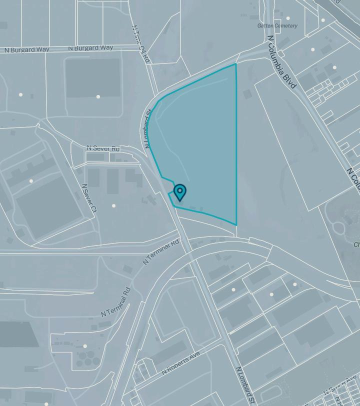
The material and information on this website are made available for general informational purposes only. Although Metro makes reasonable efforts to ensure the accuracy, completeness, and currency of this information, the data and maps may contain errors or inaccuracies. No representations or warranties of any kind, express or implied, are provided.
Metro councilor
Residential hauler Arrow Sanitary
Residential hauler phone (503) 257-3993
Commercial hauler Unfranchised
Commercial hauler phone No data
Dropbox provider Unfranchised
Dropbox provider phone No data
School district PORTLAND
School district number 1J
Fire district No data
Park district No data
Sewer district No data
Water district No data
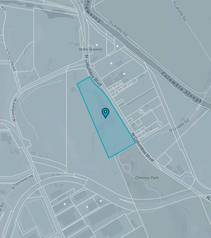
The material and information on this website are made available for general informational purposes only. Although Metro makes reasonable efforts to ensure the accuracy, completeness, and currency of this information, the data and maps may contain errors or inaccuracies. No representations or warranties of any kind, express or implied, are provided.
City
Metro councilor
Sub-watershed
Sub-basin
Residential hauler Arrow Sanitary
Residential hauler phone (503) 257-3993
Commercial hauler Unfranchised
Commercial hauler phone No data
Dropbox provider Unfranchised
Dropbox provider phone No data
School district PORTLAND
School district number 1J
Fire district No data
Park district No data
Sewer district No data
Water district No data
Searched location: 2N1W35D -01500
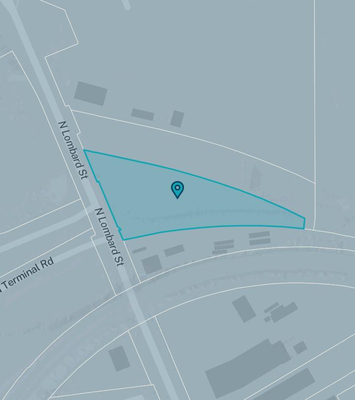
The material and information on this website are made available for general informational purposes only. Although Metro makes reasonable efforts to ensure the accuracy, completeness, and currency of this information, the data and maps may contain errors or inaccuracies. No representations or warranties of any kind, express or implied, are provided.
Metro councilor
Residential hauler Arrow Sanitary
Residential hauler phone (503) 257-3993
Commercial hauler Unfranchised
Commercial hauler phone No data
Dropbox provider Unfranchised
Dropbox provider phone No data
School district PORTLAND
School district number 1J
Fire district No data
Park district No data
Sewer district No data
Water district No data
Searched location: 2N1W35D -01400
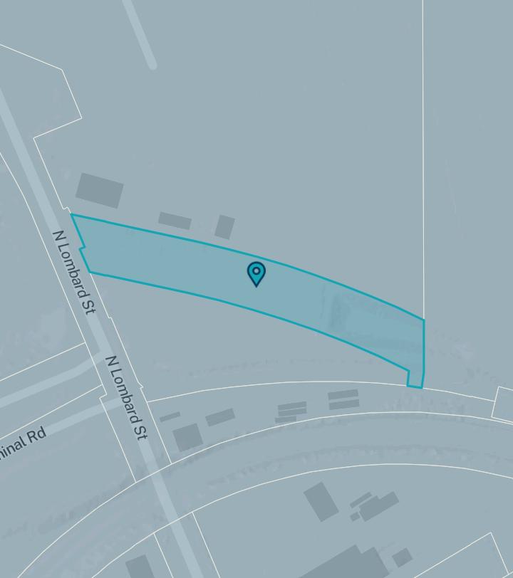
The material and information on this website are made available for general informational purposes only. Although Metro makes reasonable efforts to ensure the accuracy, completeness, and currency of this information, the data and maps may contain errors or inaccuracies. No representations or warranties of any kind, express or implied, are provided.
City
Metro councilor
Residential hauler Arrow Sanitary
Residential hauler phone (503) 257-3993
Commercial hauler Unfranchised
Commercial hauler phone No data
Dropbox provider Unfranchised
Dropbox provider phone No data
School district PORTLAND
School district number 1J
Fire district No data
Park district No data
Sewer district No data
Water district No data
The material and information on this website are made available for general informational purposes only. Although Metro makes reasonable efforts to ensure the accuracy, completeness, and currency of this information, the data and maps may contain errors or inaccuracies. No representations or warranties of any kind, express or implied, are provided.
Metro councilor
Sub-watershed
Sub-basin
Residential hauler Arrow Sanitary
Residential hauler phone (503) 257-3993
Commercial hauler Unfranchised
Commercial hauler phone No data
Dropbox provider Unfranchised
Dropbox provider phone No data
School district PORTLAND
School district number 1J
Fire district No data
Park district No data
Sewer district No data
Water district No data
Topography
CUSTOM
MAPS
Water Features
Aerial
Aerial Environmental
Community
Transit
Vacant Land
The information contained is provided by WFG’s Customer Service Department to our customers, and while deemed reliable, is not guaranteed.
Tran sit
COMMUNITY
Demographics
Traffic Counts
The information contained is provided by WFG’s Customer Service Department to our customers, and while deemed reliable, is not guaranteed.

11920 N Lombard St, Portland, OR 97203
11920 N Lombard St, Portland, OR 97203 Sitewise Online
Pop-Facts: Demographic Quick Facts
Pop-Facts:
Copyright © Claritas, LLC 2025. All rights reserved.
11920 N Lombard St, Portland, OR 97203
Sitewise Online
11920 N Lombard St, Portland, OR 97203 Sitewise Online
Pop-Facts: Demographic Snapshot (Part 1)
11920 N Lombard St, Portland, OR 97203 Sitewise Online
Pop-Facts:
11920 N Lombard St, Portland, OR 97203 Sitewise Online
Pop-Facts: Demographic Snapshot (Part 2)
Pop-Facts: Demographic Snapshot (Part 2) 11920
11920 N Lombard St, Portland, OR 97203 Sitewise Online
Pop-Facts: Demographic Snapshot (Part 2)
Pop-Facts: Demographic Snapshot (Part 2)
Pop-Facts: Demographic Snapshot (Part 2)
Pop-Facts: Demographic Snapshot (Part 2)
11920
11920 N Lombard St, Portland, OR 97203 Sitewise Online
Pop-Facts: Demographic Snapshot (Part 2)
Pop-Facts: Demographic Snapshot (Part 2) 11920 N
Copyright © Claritas, LLC 2025. All rights reserved.
* This row intentionally left blank. No Total Category.
**1939 will appear when at least half of the Housing Units in this reports area were built in 1939 or earlier.
11920 N Lombard St, Portland, OR 97203
Total retail trade including food and drink (NAICS 44, 45 and 722)
and parts dealers (NAICS 441)
dealers (NAICS 4411)
(NAICS 44111)
(NAICS 44112)
(NAICS 44121)
44122)
44412)
(NAICS 44419)
(NAICS 4442)
44421)
garden center, and farm supply stores (NAICS 44422)
(NAICS 445)
stores (NAICS 4451)
and other grocery (except convenience) stores (NAICS 44511)
stores (NAICS 44512)
food stores (NAICS 4452)
11920 N Lombard St, Portland, OR 97203 Sitewise Online
Retail Market Power Opportunity Gap Report By Retail Store Types
Retail Market Power Opportunity Gap Report By Retail Store Types
(NAICS 44521)
(NAICS 44522)
(NAICS 44523)
(NAICS 44529)
luggage, and leather goods stores (NAICS 4483)
(NAICS 451)
4511)
stores (NAICS 45111)
needlework, and piece goods stores (NAICS 45113)
(NAICS 452)
(NAICS 4523)
11920 N Lombard St, Portland, OR 97203
11920 N Lombard St, Portland, OR 97203 Sitewise
Online
Retail Market Power Opportunity Gap Report By Retail Store Types
Retail Market Power Opportunity Gap Report By Retail Store Types
store retailers (NAICS 453)
(NAICS 4531)
stationery, and gift stores (NAICS 4532)
and stationery stores (NAICS 45321)
(NAICS 45322)
(NAICS 4533)
miscellaneous store retailers (NAICS 4539)
(NAICS 45392)
(NAICS 45391)
(NAICS 45393)
(NAICS 45399)
(NAICS 453991)
miscellaneous store retailers (except tobacco stores) (NAICS 453998)
retailers (NAICS 454)
* GAFO (General merchandise, Apparel, Furniture and Other) represents sales at stores that sell merchandise normally sold in department stores. This category is not included in Total Retail Sales Including Eating and Drinking Places.
11920 N Lombard St, Portland, OR 97203
11920 N Lombard St, Portland, OR 97203 Sitewise Online
Retail Market Power Opportunity Gap Report By Retail Store Types
Retail Market Power Opportunity Gap Report By Retail Store Types
Retail Market Power data is derived from two major sources of information. The demand data is derived from the Consumer Expenditure Survey (CE Survey or CEX), which is fielded by the U.S. Bureau of Labor Statistics (BLS). The supply data is derived from the Census of Retail Trade (CRT), which is made available by the U.S. Census. Additional data sources are incorporated to create both supply and demand estimates. The difference between demand and supply represents the opportunity gap or surplus available for each merchandise line in the specified reporting geography. When this difference is positive (demand is greater than the supply), there is an opportunity gap for that merchandise line; when the difference is negative (supply is greater than demand), there is a surplus.
Copyright © 2025 Environics Analytics. All rights reserved.
11920 N Lombard
11920 N Lombard St, Portland, OR 97203
November 24, 2025