
International Research Journal of Engineering and Technology (IRJET) e-ISSN: 2395-0056
Volume: 12 Issue: 03 | Mar 2025 www.irjet.net p-ISSN: 2395-0072


International Research Journal of Engineering and Technology (IRJET) e-ISSN: 2395-0056
Volume: 12 Issue: 03 | Mar 2025 www.irjet.net p-ISSN: 2395-0072
Sanket S Motale1, Sampada S Urankar 2 ,
1Head of Civil Engineering Department Samajbhushan Eknathrao Dhakane College of Engineering Shevgaon
2Lecturer Civil Engineering Department Samajbhushan Eknathrao Dhakane College of Engineering Shevgaon ***
Abstract - A computer-based tool for mapping and evaluating geographical phenomena and occurrences on Earth is the geographic information system (GIS). Common database integration is a feature of GIS. It has functions like statistical analysis and inquiry. This feature sets GIS apart from other information systems and makes it useful for a variety of public and commercial businesses in terms of forecasting results, planning strategies, and explaining occurrences. Landslides, watershed management, urban planning, water resource engineering, and other areas are among the many uses of GIS in civil engineering. One of the natural disasters that involves the movement of rock, debris, and soil as a result of slope collapse and gravity is a landslide. There are fundamental causal factors that only determinethe severity and degree of landslide episodes, which might vary. Water always plays a part in social movements. Slopecollapse is frequently caused by human activities in additionto natural causes. It results in propertydamage,fatalities,anddamageto buildings. The use of GIS for landslides is covered in this work. In order to prevent landslides, preventive measures are also recommended.
Key Words: GIS,landslide,civil,engineering,slope,failure.
The fundamental area of engineering that has many applicationsinpeople'sdailylivesiscivilengineering.One computer-basedtechnologythatishelpfulinmanydifferent industriesistheGeographicInformationSystem,orGIS.It has the ability to store data and process it to produce an output.Geotechnicalengineering,watershedmanagement, pollution monitoring, transportation management, architecturalplanning,andotherareasofcivilengineering allbenefitfromtheuseofGIS.Oneofthenaturaldisasters that involves the movement of rock, debris, and soil as a resultofslopecollapseandgravityisalandslide.Thereare fundamentalcausalfactorsthatonlydeterminetheseverity anddegreeoflandslideepisodes,whichmightvary.Water always playsa partinsocial movements.Slopecollapse is frequentlycausedbyhumanactivitiesinadditiontonatural causes.Itresultsinpropertydamage,fatalities,anddamage tobuildings.AccordingtoVanWestenetal.(2006),theyare oftenseparateprocessesthatcanhappenfrequentlyevenif theymaynotbeparticularlysubstantialontheirown.
According to Varnes (1984), landslide hazard is the likelihoodthatlandslideswilloccurinsideaparticulararea and over a certain time period. Cruden (1991) defined a landslideasthemovementofamassofsoil,rock,ordebris downaslope.Scheidegger(1994)defineditasthelikelihood that a situation that is relatively steady might change suddenly.Thesize,volume,andvelocityoftheanticipated landslideshouldbeincludedinthedefinition,accordingto Guzzetti et al. (1999). Sharma (1996) underlined that the location and magnitude of a landslide should serve as the foundationforathoroughhazardassessmentandmapping.
Landslides are caused by many activities, such as falling, sliding, and flowing from one location to another,thatcausematerialsmadeofrocks,soils,manmade fills, or a mix of these elements to move downhill and outwardalongsurfacesofseparation.Evenwhilelandslides aremostlyassociatedwithhillyterrain,theycanalsohappen in places where open pit mining, surface excavation for structures,androadwaysareconducted.Thematerialsmay movebyslipping,spreading,toppling,dropping,orflowing. While some landslides happen quickly in a matter of seconds others may take hours, weeks, or even longer. Rainfall, earthquakes, geology, gravity, weather, groundwater, wave action, and human activity are all elementsthatcancauselandslides.Landslidescanhappenin placeswithlittlerelief,eventhoughtheyusuallyhappenon steep hills. Slope failures related to quarries and open-pit mining, cut-and-fill failures that may accompany constructionandhighwayexcavations,andgroundcollapse of river bluffs can all result in landslides. The word "landslide"referstoabroadrangeofprocessesthatcause rock,soil,artificialfill,oramixofthesetomoveoutwardand downwardandproduceslopes.Thematerialscanmoveby slipping, spreading, toppling, collapsing, or flowing. The sortsofmaterialusedandthewaytheytravelmaybeused to distinguish between the different types of landslides. Table 1 displays a categorization scheme based on these criteria.Additionalfactorsincludingthepaceofmovement andtheamountofwater,air,oriceinthelandslidedebris areincludedinothercategorizationschemes.

International Research Journal of Engineering and Technology (IRJET) e-ISSN: 2395-0056
Volume: 12 Issue: 03 | Mar 2025 www.irjet.net p-ISSN: 2395-0072
Falls RockFall Debrisfall Earthfall
Topples RockTopple Debris topple Earthtopple
Slides Rotational Translational Rockslide Debris slide Earthslide
Lateralspreads Rockspread Debris spread Earthspread
Flows Rock flows (deep creep) Debris flows Earthflow (soilcreep)
Complexmovements Combinationoftwoormoreprincipaltypes ofmovement
Table -1: Landslidetypesandthecondensedformof Varnes'slopemovementcategorization(Varnes1978)
LandslidesoccurregularlyinIndia'shillyregions.Landslides can be caused by a variety of factors, including human involvement, rainfall, earthquakes, and gravity. India is separatedintomanyzonesaccordingtolandslides.
•TheEasternandNorth-easternHimalayas(inthestatesof WestBengal,Sikkim,andArunachalPradesh);
• The Western Himalayas (in the states of Uttar Pradesh, Uttaranchal,HimachalPradesh,andJammu&Kashmir)
• The Naga-Arakkan mountain range, which includes the statesofTripura,Manipur,Mizoram,andNagaland.
•TheMeghalayaplateauinnortheasternIndia;theWestern Ghats area, which includes the Nilgiris (in the states of Maharashtra,Goa,Karnataka,Kerala,andTamilNadu);and thePeninsularIndiaPlateauboundaries.
Some of the major landslides that took place in different partsofIndiaaregiveninTable2.
August
Roadnetwork andbuildings damaged,Rs.5 milliondamage estimate
Itanagar 25peopleburiedalive,2kmroad damaged
Kalimpong ,
40peoplekilled,heavylossof property
A computer-based tool is the GIS. It is employed in the mapping and analysis of geographical phenomena and eventsthattakeplaceonEarth.Soilcharacteristics,photos, andtoposheetsarethedataneededforanalysis.Onefeature of GIS is the ability to integrate a shared database. It encompassesfunctionslikestatisticalanalysisandinquiry. GISdiffersfromotherinformationsystemsasaresult.Itis helpfulandimportanttoavarietyofpublicandcommercial companiesforstrategydevelopment,resultprediction,and eventexplanation.
TherearefourprimaryfunctionalsubsystemsofGIS.They are:
a. Datainputsystem
b. Datastorageandretrievalsubsystem
c. Datamanipulationandanalysissubsystem
d.Dataoutputanddisplaysubsystem
GISusesitsownhardwaretofunction.GISreliesheavilyon data. Spatial data may be integrated with other available dataresourceswiththehelpofGIS.Oneimportantfeature thatGISoffersistheabilitytointegratetabulardatastored inaDBMSwithgeographicaldata.Peoplewhooverseethe GISsystemplayacrucialrole.

International Research Journal of Engineering and Technology (IRJET) e-ISSN: 2395-0056
Volume: 12 Issue: 03 | Mar 2025 www.irjet.net p-ISSN: 2395-0072
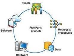
The components of GIS are:
a) Data
b) Software
c) Hardware
d) MethodsandProcedures
e)People
TheGIScomponentsareshowninFigure1
The approach includes:
a)Literaturestudyonthecausesandremediesoflandslides.
b) Gathering geotechnical and geographical data for the necessaryresearch.
c) To create thematic maps utilizing satellite imagery, District Resource Maps, and Survey of India (SOI) Toposheets.
d)Togatherthesampleinordertoascertainitsgeotechnical characteristics.
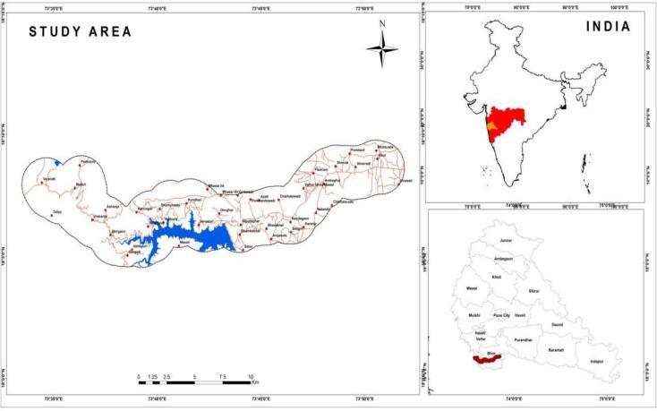
Therearehills,valleys,woods,farms,settlements,andother featuresintheVarandhaGhatregion.Withlatitudes18°04′ 34.77′′Nto18°09′46.37′′Nandlongitudes73°33′29.13′′E to73°51′54.81′′E,itissituatedintheBhorandVelhataluka ofthePunedistrict.Figure2'slocationmapoftheresearch region was created using Survey of India toposheets E 43 H/12andE43H/16,whichhaveascaleof1:50,000.IV.
Variousthemedmapsarecreatedusingthebasemapand remotesensingdata.Contouranddrainagemapsarecreated by digitizing the catchment area border contours and drainageonthebasemap.Georeferencingwasdoneonthe satellite data. Using controlled points that were already createdonthebasemap,scannedmapsweregeo-referenced inQGIS.Followingcorrection,thefourcontrolpointsinthe upperleft,lowerright,andlowerrightcornersofthemap were given the appropriate latitude and longitude values. QGIS software was then used to turn the points into a polyconic projection scheme. QGIS software was used to digitize scanned maps on-screen, and any problems that arose during the digitization process were fixed with the proper editing. Following completion, error-free coverage characteristicswereallocatedtovariouslanduse,drainage, andsoilgroups,amongothers.
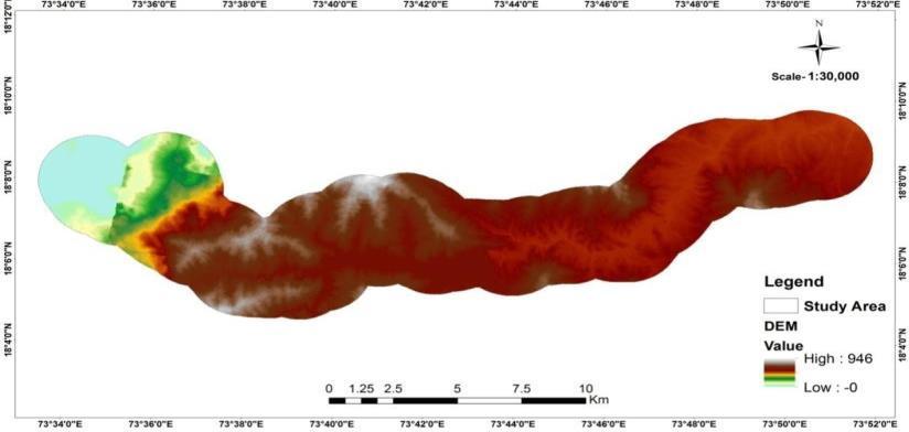
AltitudedatacanberepresenteddigitallyinaGIS system. DEM is the name of this system. It is therefore a computationaldepictionofthereliefoftheplanet.ADEMis a three-dimensional depiction of a terrain's surface. Triangulatedirregularnetworks,contourlines,conventional grids,anddisperseddatapointsareamongtheseveralforms (Gopi et al., 2007). Numerous fields of study, including geology,geomorphology,landscape,education,andhealth, can use it as a key input. For the DEM, topographic maps with contours are necessary. The topographic map is transformed into a digital version during the scanning procedure. Typically, it is included into the GIS database. Figure3displaystheresearcharea'sDEM.

International Research Journal of Engineering and Technology (IRJET) e-ISSN: 2395-0056
Volume: 12 Issue: 03 | Mar 2025 www.irjet.net p-ISSN: 2395-0072
In order to determine the locations of villages, landslides, soil types, rock types, land use, and land cover, a comprehensivefieldsurveywascarriedoutintheVarandha Ghat using GPS. We spoke with residents of these communities and learned about landslides. It was determinedwhichrocks,minerals,andgeologicformations werepredominant.Itwasobservedthattherewererivers, streams,bodiesofwater,flora,etc.Welookedathistorical rainfall, land use, and landslide data. Residents and local governmentagenciesalsoprovideinformation.
Afterobservingthesoilsamplesduringthefieldvisits,we were able todeterminethe kindofsoil.Wehaveseen the kindofrock,theflora, erosion,thesafetymeasuresput in placetopreventlandslides,etc.
Table3:FieldObservationsoftheVarandhaGhat

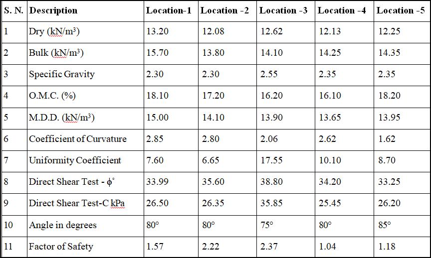
Theparametersofthesoilsampleswereascertainedinthe laboratory after they were taken from the location. The stabilityofaslopeiscomputedusingthesecharacteristics. Remedial actions might be recommended based on the safetyfactor.
Table4:TypicalPropertiesofsoilmassandFactorof SafetyatdifferentlocationsforVarandhaGhat
The research area's theme maps were created. Along the StateHighwaythatconnectsBhorandMahad,severalareas havebeenidentifiedasbeingatriskoflandslides.Atoolfor covering a wider area for examination is the GIS. The landslide-prone areas along the Bhor to Mahad State Highway are depicted in Figure 4. Remedial actions were also recommended to prevent landslide-related property andhumancasualties.
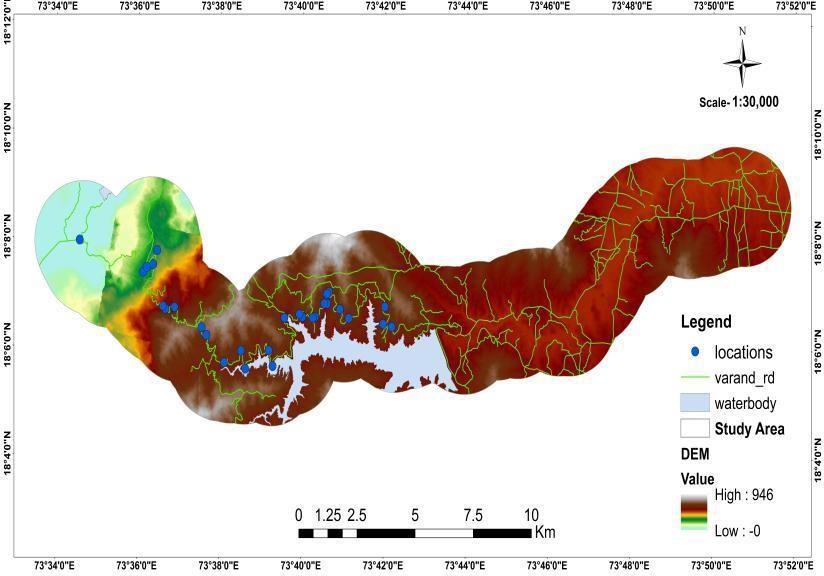
Figure4:LocationofthestudypointsofVarandhaGhat
Landslide Prevention Measures: Avarietyoftechniques areemployedtostoplandslides.Avoidthelandslide-prone areaasmuchasyoucan.
Beforebuyinganylandorbuilding,theopinionofageologist orgeotechnicalengineershouldbesought.Somecorrective actionstopreventlandslidesarelistedbelow.
a) Enhancing surface and subsurface drainage: Since water is a major contributing factor to landslides, a landslide-proneslope'sstabilitycanberaisedbyenhancing surface and subsurface drainage at the location. Water shouldbedirectedinadrainageditchtotheslope'sbasein ordertodrainsurfacewaterawayfromthelandslide-prone area. To prevent causing a landslide next to the site, the watershouldbedrainedcarefully.On thelandslide-prone slope,surfacewatershouldn'tbelettoaccumulate.
b) Slope Vegetation: Vegetating the slope is one of the simplest ways to prevent landslides along it. If the movementhasn'tstartedyetortheslopeisn'ttoosteep,this landslidepreventiontechniquecanbeused.Onecaneither employ a landscaper to vegetate the slope or do it themselvesbyplantinggroundcover.
d) Retaining walls:
To withstand the lateral pressure of soil, a strong, welldesigned retaining should be constructed from durable materialslikesteel,stone,brick,ormasonry.Awell-designed

International Research Journal of Engineering and Technology (IRJET) e-ISSN: 2395-0056
Volume: 12 Issue: 03 | Mar 2025 www.irjet.net p-ISSN: 2395-0072
drainage system behind the wall contributes to the wall's increasedstability.
d) Diverting Debris Pathways: By creating pathways to redirect debris, you can stop landslides on your property. Retainingwallscanbeusedtobuildtheseroutes.However, youareresponsibleforanydamageifthisdebrisflowends up on your neighbor's property because of the wall construction
[1] Cruden, D. M. (1991), “A simple definition of a landslide”.BulletinoftheInternationalAssociationof Engineering Geology. Pp. 27-29. DOI: 10.1007/BF02590167
[2] GopiS.,SathikumarR.,andMadhuN.,(2007),Text bookofAdvancedSurveying-TotalStation,GISand RemoteSending,Pearson.
[3] Guzzetti, F., Carrara, A., Cardinali, M. and Reiehenbaeh, P. (1999). “Landslide hazard evaluationareviewofcurrenttechniquesandtheir application in a multi-scale study”. Central Italy. Geomorphology,Vol.31,pp.181-216.
[4] Scheidegger,A.E.(1994)."Hazards:singularitiesin geomorphicsystems."Geomorphology,Vol.10,Pp. 19-25.
[5] Sharma, V. K., (1996), “A probabilistic approach of landslide zonation mapping in Garhwal Himalaya”. ProceedingsInternationalSymposiumonlandslides, Trondhein.Norway,17-21June,1996,pp.381-386.
[6] Varnes, D. J. (1984). “Landslide hazard zonation: a review of principles and practice”, United Nations International,Paris.Pp.1-55.
[7] Varnes, D. J. (1978), "Slope Movement Types and Processes." In: Schuster, R.L. and Krizek, R.J., Eds., Landslides, Analysis and Control, Transportation Research Board, Special Report No. 176, National AcademyofSciences,11-33.
[8] Van Westen, C. J., Van Asch, T.W.J. and Soeters, R. (2006),“Landslidehazardandriskzonation–whyitis stillsodifficult?”,Bull.Engg.Geol.Env.Vol.65,pp.167184.