34 East Concourse, Beaumaris - Information Memorandum
As Melbourne’s leading independent commercial property agency, we take pride in creating worth across all four points of this city.
01. Point of Interest 02. Point of View
Property Features 04. Property Particulars 05. Location
06. Sales Process
07. Appendices Zone and Overlays
Public Auction Thursday 27th November at 12pm onsite
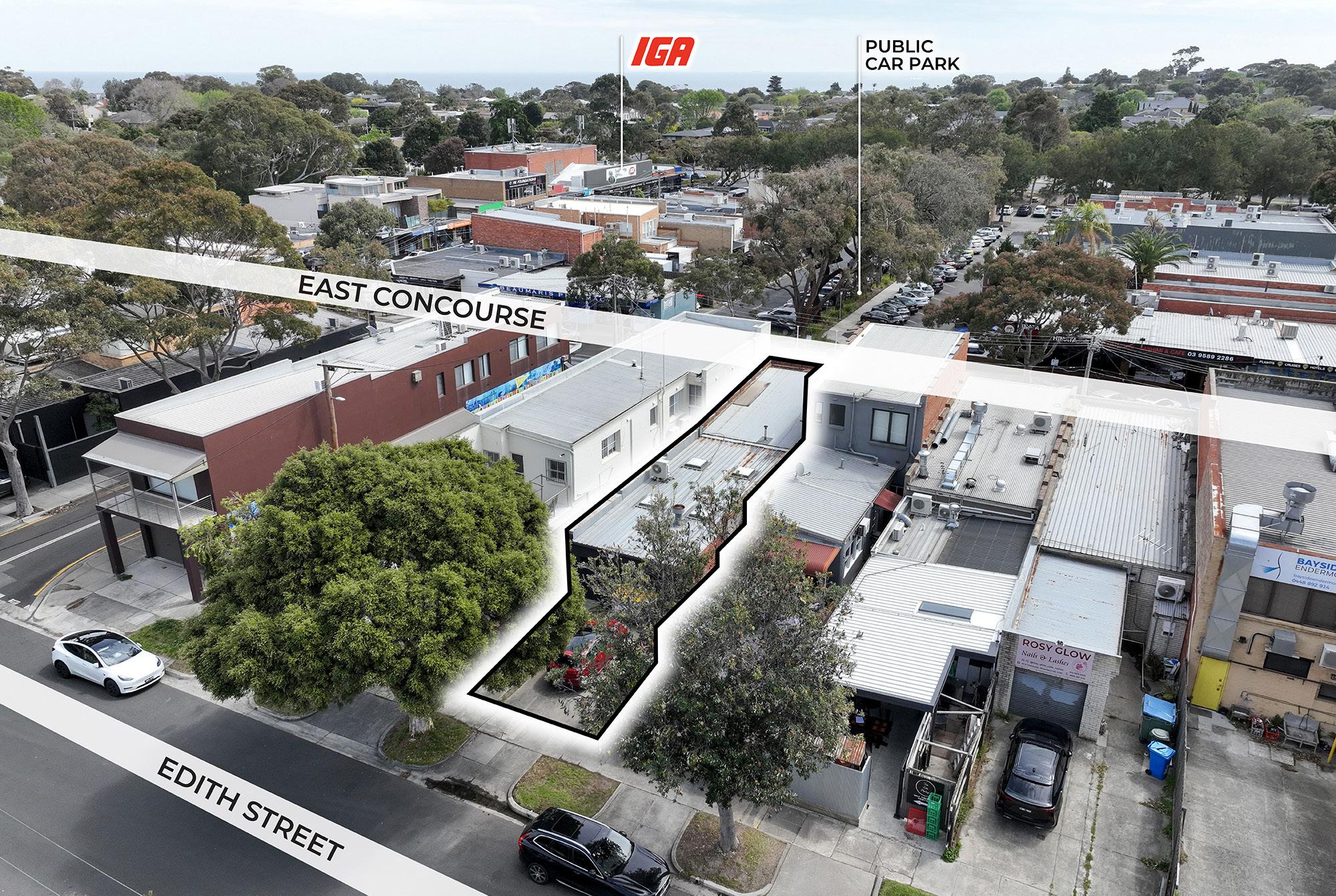
Like a timeless designer piece, 34 East Concourse is cut to perfection — refined, versatile, and impossible to overlook. Anchored in the heart of Beaumaris’ iconic Concourse, this freehold retail investment pairs classic commercial fundamentals with great taste. Currently leased to fashion boutique Jorge Lifestyle since 2008, the single-level shop presents a clean, light-filled interior of 146.5 sqm*, complete with heating and cooling, staff amenities, and valuable rear access with 2 on-title car spaces. With over 300 public car parks right at the doorstep and a generous 6 m* frontage, visibility and convenience are stitched into every seam. Set on 193 sqm* of Commercial 1-zoned land, this property delivers both security and style with a quality tenant in place and the flexibility to adapt for future retail, café, or hospitality use.
146.5 sqm*
193 sqm*
$49,624 p.a
Convenient
Leased Commercial 1
2
Allocated car spaces.
860 m*
Total building area.
Total land area.
Leasing income from April 2026. Perfectly surrounded by everyday conveniences and local favorites.
long-term tenant since 2008. Zone.
To Beach road.
Tightly held, consistently in demand, and proven to stand the test of time — for investors chasing a strong yield in a postcode that never goes out of fashion, this is the perfect fit.
“A proven tenant, strong yield, and unbeatable Beaumaris location — this is a secure investment with timeless appeal.”
Tim Cooney | 0468 860 737 tim.cooney@cva.melbourne Property Executive | Southern Region
After nearly two decades of experience across Australia and London, Tim brings a global perspective to local deals — paired with a distinctly Melbourne sense of approachability. Since joining CVA in 2021, he’s become known for his attention to detail, proactive mindset, and long-game thinking. For Tim, commercial real estate isn’t about chasing transactions, but building partnerships. He thrives on developing genuine, long-term relationships and takes the time to understand not just what clients want now, but what they’ll need next. Tim blends strategic thinking with day-to-day diligence, whether he’s running a campaign, structuring a deal or mapping out a multi-year leasing strategy, his goal is the same: deliver value, build trust, and exceed expectations.
“Stylish, stable, and set in Bayside’s best retail strip — 34 East Concourse is a smart addition to any portfolio.”
Honest. Ambitious. Professional. From scaffolding sites to sales doors, Stirling built his work ethic the hard way — early starts, long days and zero shortcuts. But it was in commercial real estate that he found his stride: where discipline meets people, hustle meets strategy, and every move is about doing right by clients — helping each make decisions that matter, not just closing deals. Because Stirling knows, real estate can be complicated — but it doesn’t have to be. As the bridge, he spots opportunities, clears obstacles, and keeps clients connected to what matters most. The outcome? Smarter strategies, stronger deals, and relationships that last well beyond the contract.
A well-presented single-level retail building that offers a bright and inviting interior, ideal for a variety of retail or lifestyle uses. The open-plan layout is complemented by polished timber flooring, high ceilings, and extensive downlighting, creating a warm and modern shopping environment.
Large display windows provide excellent natural light and street visibility, enhancing the sense of space while drawing attention from passing foot traffic. The interior fit-out features built-in shelving, hanging rails, and display zones, all arranged to maximise functionality and presentation.
The rear portion includes a comfortable lounge or fitting area, staff amenities, and direct rear access for deliveries and convenience. The property also benefits from two on-title car spaces and is positioned just steps away from over 300 public car parks within The Concourse precinct.
Meticulously maintained and tastefully finished, this property combines quality presentation with strong commercial fundamentals — a ready-made investment in one of Bayside’s most enduring retail locations.
Principle Outgoings
Site
Title particulars
Certificate of Title — Volume 8207 Folio 232 Lot. 34 LP40619
Zoning Commercial 1 Zone (CIZ)
Planning Overlays
Development Contributions Plan Overlay - Schedule 1 (DCPO1)
Design And Development Overlay - Schedule 7 (DDO7)
Special Building Overlay (SBO) Vegetation Protection Overlay - Schedule 3 (VPO3)
Municipality City of Bayside
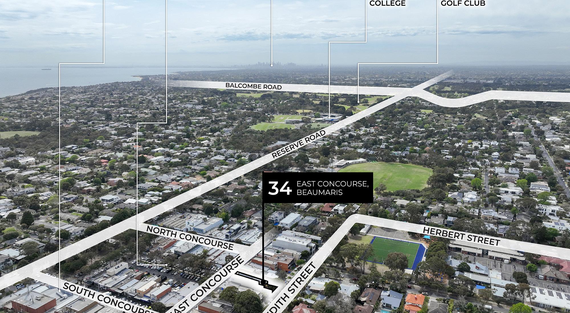
All signs point to: East Concourse.
Positioned in the heart of Beaumaris, East Concourse offers a thriving retail environment that blends community charm with enduring commercial strength. Here are some notable aspects and benefits of buying property in this area:
Established Retail Precinct:
East Concourse stands as the beating heart of Beaumaris’ local commerce, known for its boutique atmosphere and high community engagement. The area enjoys consistent daily foot traffic from both loyal residents and visitors who frequent the Concourse for dining, shopping, and services.
Affluent Local Demographics:
The surrounding Bayside community is one of Melbourne’s most desirable residential pockets, home to established families and professionals with strong disposable income. This demographic base creates steady demand for premium retail, fashion, and lifestyle offerings.
Ample Customer Parking:
With over 300 public car parks available throughout The Concourse, businesses benefit from exceptional accessibility and convenience. Easy parking encourages longer visits and repeat patronage, supporting sustained customer flow throughout the week.
Vibrant Retail and Service Mix:
The precinct hosts a healthy blend of local favourites and well-known retailers such as IGA, Hagen’s Organics, Terry White, and Beaumaris Cellars. This synergy between established brands and boutique operators enhances cross-exposure and creates a thriving commercial ecosystem.
Prime Coastal Position:
Located just 860 metres from Beach Road, East Concourse captures a unique blend of local and coastal traffic. Its proximity to the beach and main arterial routes makes it a preferred stop for shoppers, professionals, and weekend visitors, strengthening its longterm commercial appeal.
34 East Concourse places your business in a highly visible, tightly held retail strip surrounded by strong local operators, steady foot traffic, and an affluent customer base — ensuring long-term growth and stability in one of Bayside’s most sought-after commercial hubs. AND THE POINT?
All signs point to: Beaumaris.
Beaumaris is one of Melbourne’s most coveted Bayside suburbs, renowned for its pristine coastline, leafy streets, and timeless village atmosphere. Set along Port Phillip Bay, the suburb offers a perfect balance between seaside relaxation and urban convenience, attracting professionals, families, and retirees who value quality living and community connection.
The area is anchored by The Concourse — a vibrant local hub filled with cafés, boutiques, medical services, and specialty retailers that serve as the heart of daily life in Beaumaris. This strong sense of community fosters consistent foot traffic and loyal patronage, making it an ideal environment for local businesses to flourish.
Beyond its retail appeal, Beaumaris boasts a wealth of lifestyle amenities, including top-rated schools, sporting clubs, scenic walking trails, and easy access to public transport. Its proximity to
Beach Road also ensures strong exposure to both local residents and visitors exploring Melbourne’s famous Bayside strip.
With its mix of affluence, accessibility, and enduring charm, Beaumaris remains a highly desirable location for business owners and investors seeking stability and long-term growth in a truly premium coastal setting.
And the point?
Tightly held, consistently in demand, and positioned within one of Bayside’s most established retail strips — 34 East Concourse offers investors the rare combination of security, style, and long-term performance. With a quality tenant in place and exceptional local amenity at its doorstep, this freehold investment delivers lasting appeal in a location that continues to stand the test of time.
SALES PROCESS AUCTION
Public Auction Sale Process
At CVA Property Consultants, we are committed to providing a transparent and structured approach to public auctions, ensuring all interested buyers have an equal opportunity to participate. Here is an outline of the key steps in our auction process:
1. Registering to Bid
We request that all interested parties register prior to auction, to ensure they are kept informed of any changes or updates. Registration can be done with the agent you are dealing with or on-site or online, depending on the auction format. Please ensure you provide all required identification and contact detai
2. Auction Day
On the day of the auction, the property will be offered for sale to the highest bidder. Bidding will be open, and participants can place bids. The auctioneer will guide the process, and once the highest bid is reached and meets the vendor’s reserve price, the property will be declared sold to that bidder. If the reserve is not met, the vendor may choose to negotiate with the highest bidder or withdraw the property from sale.
3. Contract and Settlement
Following a successful auction, the winning bidder must immediately sign the contract of sale and pay a deposit (10% of the purchase price). The remaining terms, including the settlement date, will be finalised between the vendor and the successful buyer. The property is considered sold upon the fall of the hammer, and both parties are legally bound by the contract at this point.
We are dedicated to clear communication and ensuring that all participants are fully informed throughout the public auction process. Our goal is to facilitate a seamless and respectful transaction for all parties involved.
REIV Auction Rules:
1. The Auctioneer may make one or more bids on behalf of the vendor of the land at anytime during the Auction.
2. The Auctioneer may refuse any bid.
3. The Auctioneer may determine the amount by which the bidding is to be advanced.
4. The Auctioneer may withdraw the property from sale at any time.
5. The Auctioneer may refer a big to the vendor at any time before the conclusion of the Auction.
6. In the event of a dispute concerning a bid, the Auctioneer may re-submit the property for sale at the last undisputed bid or start the bidding again.
7. The Auctioneer must not accept any bid or offer for a property that is made after the property has been knocked down to the successful bidder, unless the vendor or successful bidder at the Auction refuses to sign the contract following the auction.
8. If a reserve price has been set for the property and the property is passed on below the reserve price, the vendor will first negotiate with the highest bidder for the purchase of the property.
For more information, contact
Tim Cooney
0404 530 393
john.nockles@ cva.melbourne
Stirling Findlay
0481 848 240 stirling.findlay@ cva.melbourne
SALES PROCESS
BAYSIDE PLANNING SCHEME
COMMERCIAL 1 ZONE
Shown on the planning scheme map as B1Z , B2Z , B5Z or C1Z
Purpose
To implement the Municipal Planning Strategy and the Planning Policy Framework
To create vibrant mixed use commercial centres for retail, office, business, entertainment and community uses.
To provide for residential uses at densities complementary to the role and scale of the commercial centre.
Operation
A schedule may apply under this zone to a planning scheme outside of metropolitan Melbourne That schedule may:
specify the maximum leasable floor area for office
specify the maximum leasable floor area for shop (other than restricted retail premises)
- Permit not
SALES PROCESS
BAYSIDE PLANNING SCHEME
Use
Informal outdoor recreation
Office
Place of worship
Railway
Retail premises (other than Shop)
Rooming house
Shop (other than Adult sex product shop)
Tramway
Any use listed in Clause 62.01
Section 2 - Permit required
Use
Adult sex product shop
Condition
The leasable floor area for all offices must not exceed any amount specified in the schedule to this zone.
The gross floor area of all buildings must not exceed 250 square metres.
Any frontage at ground floor level must not exceed 2 metres.
Must meet the requirements of Clause 52.23-2.
The leasable floor area for all shops must not exceed any amount specified in the schedule to this zone.
Must meet the requirements of Clause 62.01.
Condition
Must be at least 200 metres (measured by the shortest route reasonably accessible on foot) from a residential zone or, land used for a hospital, primary school or secondary school or land in a Public Acquisition Overlay to be acquired for a hospital, primary school or secondary school.
Agriculture (other than Animal production and Apiculture)
Container deposit scheme centre
Grazing animal production
Industry (other than Automated collection point and Container deposit scheme centre)
Leisure and recreation facility (other than Informal outdoor recreation, Major sports and recreation facility and Motor racing track)
Must not be a purpose listed in the table to Clause 53.10.
Page 2 of 8
SALES PROCESS
34 01-2
15/07/2013
VC100
Use
Place of assembly (other than Carnival, Cinema, Cinema based entertainment facility, Circus, Exhibition centre and Place of worship)
Utility installation (other than Minor utility installation and Telecommunications facility)
Warehouse
Any other use not in Section 1 or 3
Condition
Must not be a purpose listed in the table to Clause 53.10.
Must not be a purpose listed in the table to Clause 53.10.
34.01-3
31/07/2018
VC148
Section 3 - Prohibited
Use
Animal production (other than Grazing animal production)
Corrective institution
Major sports and recreation facility
Motor racing track
Small second dwelling
Use of land
A use must not detrimentally affect the amenity of the neighbourhood, including through the:
Transport of materials, goods or commodities to or from the land
Subject to Clause 71.06, an application under this clause for a development specified in Column 1 is a class of VicSmart application and must be assessed against the provision specified in Column 2.
Class of application
Subdivide land to realign the common boundary between 2 lots where:
The area of either lot is reduced by less than 15 percent. The general direction of the common boundary does not change.
Information requirements and decision guidelines
Clause 59.01
3 of 8
BAYSIDE PLANNING SCHEME
SALES PROCESS
Class of application
Subdivide land into lots each containing an existing building or car parking space where:
The buildings or car parking spaces have been constructed in accordance with the provisions of this scheme or a permit issued under this scheme.
An occupancy permit or a certificate of final inspection has been issued under the Building Regulations in relation to the buildings within 5 years prior to the application for a permit for subdivision.
Subdivide land into 2 lots if:
The construction of a building or the construction or carrying out of works on the land:
– Has been approved under this scheme or by a permit issued under this scheme and the permit has not expired.
– Has started lawfully
The subdivision does not create a vacant lot.
34 01-4
01/12/2023
VC217
Buildings and works
Information requirements and decision guidelines
A permit is required to construct a building or construct or carry out works
This does not apply to:
The installation of an automatic teller machine
An alteration to an existing building façade provided:
The alteration does not include the installation of an external roller shutter
At least 80 per cent of the building facade at ground floor level is maintained as an entry or window with clear glazing
An awning that projects over a road if it is authorised by the relevant public land manager
An apartment development must meet the requirements of Clause 58
VicSmart applications
Subject to Clause 71 06, an application under this clause for a development specified in Column 1 is a class of VicSmart application and must be assessed against the provision specified in Column 2
Class of application
Construct a building or construct or carry out works with an estimated cost of up to $500,000 where the land is not:
Within 30 metres of land (not a road) which is in a residential zone.
Used for a purpose listed in the table to Clause 53.10.
Used for an Adult sex product shop.
Information requirements and decision guidelines
Page 4 of 8
Clause 59.02
Clause 59.02
Clause 59.04
BAYSIDE PLANNING SCHEME
SALES PROCESS
BAYSIDE PLANNING SCHEME
Transitional provisions
Clause 58 does not apply to:
An application for a planning permit lodged before the approval date of Amendment VC136
An application for an amendment of a permit under section 72 of the Act, if the original permit application was lodged before the approval date of Amendment VC136
Maintenance
All buildings and works must be maintained in good order and appearance to the satisfaction of the responsible authority
34 01-5
08/09/2025 VC282
34 01-6
14/01/2025 VC237
Site description and design response
An application for any of the following must be accompanied by a site description and a design response as described in Clause 54 01, 55 01 or 57 01, as appropriate:
Construction or extension of one dwelling on a lot of less than 300 square metres.
Construction of a dwelling if there is at least one dwelling existing on the lot.
Construction of two or more dwellings on a lot.
Extension of a dwelling if there are two or more dwellings on the lot
Construction or extension of a dwelling on common property
Construction or extension of a residential building
Clause 34.01-5 does not apply to an apartment development.
Application requirements
Use
An application to use land must be accompanied by the following information, as appropriate:
The purpose of the use and the types of activities which will be carried out.
The likely effects, if any, on adjoining land, including noise levels, traffic, the hours of delivery and despatch of goods and materials, hours of operation and light spill, solar access and glare.
The means of maintaining land not required for immediate use
If an industry or warehouse:
– The type and quantity of goods to be stored, processed or produced
– Whether a Development Licence, Operating Licence, Permit or Registration is required from the Environment Protection Authority
– Whether a notification under the Occupational Health and Safety Regulations 2017 is required, a licence under the Dangerous Goods Act 1985 is required, or a fire protection quantity under the Dangerous Goods (Storage and Handling) Regulations 2022 is exceeded
– The likely effects on adjoining land, including air-borne emissions and emissions to land and water
Buildings and works
An application to construct a building or construct or carry out works must be accompanied by the following information, as appropriate:
A plan drawn to scale which shows:
SALES PROCESS
34 01-7
31/07/2018
VC148
34 01-8
08/09/2025
VC282
BAYSIDE PLANNING SCHEME
– The boundaries and dimensions of the site
– Adjoining roads
– The location, height and purpose of buildings and works on adjoining land
– Relevant ground levels – The layout of existing and proposed buildings and works – All driveway, car parking and loading areas
– Proposed landscape areas. –
All external storage and waste treatment areas.
Areas not required for immediate use.
Elevation drawings to scale showing the colour and materials of all buildings and works
Construction details of all drainage works, driveways, vehicle parking and loading areas
A landscape layout which includes the description of vegetation to be planted, the surfaces to be constructed, site works specification and method of preparing, draining, watering and maintaining the landscape area
An application to construct or extend an apartment development, or to construct or extend a dwelling in or forming part of an apartment development, must be accompanied by an urban context report and design response as required in Clause 58.01.
Exemption from notice and review
An application to subdivide land or construct a building or construct or carry out works is exempt from the notice requirements of section 52(1)(a), (b) and (d), the decision requirements of section 64(1), (2) and (3) and the review rights of section 82(1) of the Act. This exemption does not apply to land within 30 metres of land (not a road) which is in a residential zone, land used for a hospital or an education centre or land in a Public Acquisition Overlay to be acquired for a hospital or an education centre.
Decision guidelines
Before deciding on an application, in addition to the decision guidelines in Clause 65, the responsible authority must consider, as appropriate:
General
The Municipal Planning Strategy and the Planning Policy Framework
The interface with adjoining zones, especially the relationship with residential areas
Use
The effect that existing uses may have on the proposed use.
The drainage of the land.
The availability of and connection to services
The effect of traffic to be generated on roads
The interim use of those parts of the land not required for the proposed use
Subdivision
Provision for vehicles providing for supplies, waste removal and emergency services and public transport
The effect the subdivision will have on the potential of the area to accommodate the uses which will maintain or enhance its competitive strengths
SALES PROCESS
ZONE AND OVERLAYS
Building and works
BAYSIDE PLANNING SCHEME
The movement of pedestrians and cyclists, and vehicles providing for supplies, waste removal, emergency services and public transport.
The provision of car parking.
The streetscape, including the conservation of buildings, the design of verandahs, access from the street front, protecting active frontages to pedestrian areas, the treatment of the fronts and backs of buildings and their appurtenances, illumination of buildings or their immediate spaces and the landscaping of land adjoining a road.
The storage of rubbish and materials for recycling.
Defining the responsibility for the maintenance of buildings, landscaping and paved areas
Consideration of the overlooking and overshadowing as a result of building or works affecting adjoining land in a General Residential Zone, Housing Choice and Transport Zone, Neighbourhood Residential Zone, Residential Growth Zone or Township Zone
The impact of overshadowing on existing rooftop solar energy systems on dwellings on adjoining lots in a General Residential Zone, Housing Choice and Transport Zone, Mixed Use Zone, Neighbourhood Residential Zone, Residential Growth Zone or Township Zone
The availability of and connection to services
The design of buildings to provide for solar access
The objectives, standards and decision guidelines of Clause 54, Clause 55 and Clause 57 This does not apply to an apartment development
For an apartment development, the objectives, standards and decision guidelines of Clause 58
Transitional provisions
The objectives, standards and decision guidelines of Clause 55 of this scheme, as in force immediately before the approval date of Amendment VC136, continues to apply to:
An application for a planning permit lodged before that date.
An application for an amendment of a permit under section 72 of the Act, if the original permit application was lodged before that date.
Clauses 55 and 58 of this scheme, as in force immediately before the approval date of Amendment VC174, continue to apply to:
An application for a planning permit lodged before that date
An application for an amendment of a permit under section 72 of the Act, if the original permit application was lodged before that date
Clause 55 of this planning scheme, as in force immediately before the approval date of Amendment VC267, continues to apply to:
An application for a planning permit lodged before that date
An application for an amendment of a permit under section 72 of the Act, if the original permit application was lodged before that date.
Clause 54 of this planning scheme, as in force immediately before the commencement of Amendment VC282, continue to apply to:
An application for a planning permit lodged before that date
Page 7 of 8
SALES PROCESS
BAYSIDE PLANNING SCHEME
An application for an amendment of a permit under section 72 of the Act, if the original permit application was lodged before that date
34 01-9
31/07/2018
VC148 Signs
Sign requirements are at Clause 52.05. This zone is in Category 1.
Page 8 of 8
SALES PROCESS
45 06
31/07/2018
VC148
45.06-1
19/01/2006
VC37
BAYSIDE PLANNING SCHEME
DEVELOPMENT CONTRIBUTIONS PLAN OVERLAY
Shown on the planning scheme map as DCPO with a number
Purpose
To implement the Municipal Planning Strategy and the Planning Policy Framework
To identify areas which require the preparation of a development contributions plan for the purpose of levying contributions for the provision of works, services and facilities before development can commence
Development contributions plan
A permit must not be granted to subdivide land, construct a building or construct or carry out works until a development contributions plan has been incorporated into this scheme
This does not apply to the construction of a building, the construction or carrying out of works or a subdivision specifically excluded by a schedule to this overlay
A permit granted must:
Be consistent with the provisions of the relevant development contributions plan
Include any conditions required to give effect to any contributions or levies imposed, conditions or requirements set out in the relevant schedule to this overlay
45 06-2
19/01/2006
VC37
Preparation of a development contributions plan
The development contributions plan may consist of plans or other documents and may, with the agreement of the planning authority, be prepared and implemented in stages.
The development contributions plan must:
Specify the area to which the plan applies
Set out the works, services and facilities to be funded through the plan, including the staging of the provision of those works, services and facilities
Relate the need for the works, services or facilities to the proposed development of land in the area
Specify the estimated costs of each of the works, services and facilities.
Specify the proportion of the total estimated costs of the works, services and facilities which is to be funded by a development infrastructure levy or community infrastructure levy or both.
Specify the land in the area and the types of development in respect of which a levy is payable and the method for determining the levy payable in respect of any development of land.
Provide for the procedures for the collection of a development infrastructure levy in respect to any development for which a permit is not required.
The development contributions plan may:
Exempt certain land or certain types of development from payment of a development infrastructure levy or community infrastructure levy or both
Provide for different rates or amounts of levy to be payable in respect of different types of development of land or different parts of the area
SALES PROCESS
44 05
01/07/2021 VC203
44 05-1
31/07/2018 VC148
44 05-2
16/10/2025 VC288
BAYSIDE PLANNING SCHEME
SPECIAL BUILDING OVERLAY
Shown on the planning scheme map as SBO with a number (if shown)
Purpose
To implement the Municipal Planning Strategy and the Planning Policy Framework
To identify land in urban areas liable to inundation by overland flows from the urban drainage system as determined by, or in consultation with, the floodplain management authority.
To ensure that development maintains the free passage and temporary storage of floodwaters, minimises flood damage, is compatible with the flood hazard and local drainage conditions and will not cause any significant rise in flood level or flow velocity.
To protect water quality and waterways as natural resources by managing urban stormwater, protecting water supply catchment areas, and managing saline discharges to minimise the risks to the environmental quality of water and groundwater.
Flooding management objectives and statement of risk
A schedule to this overlay may contain:
Flooding management objectives to be achieved
A statement of risk
Buildings and works
A permit is required to construct a building or to construct or carry out works, including:
A fence
Roadworks, if the water flow path is redirected or obstructed
Bicycle pathways and trails.
Public toilets.
A domestic swimming pool or spa and associated mechanical and safety equipment if associated with one dwelling on a lot.
A rainwater tank with a capacity of not more than 10,000 litres.
A pergola or verandah, including an open-sided pergola or verandah to a dwelling or small second dwelling with a finished floor level not more than 800mm above ground level and a maximum building height of 3 metres above ground level.
A deck, including a deck to a dwelling or small second dwelling with a finished floor level not more than 800mm above ground level
A disabled access ramp
This does not apply:
If a schedule to this overlay specifically states that a permit is not required
To roadworks or bicycle paths and trails constructed or carried out by or on behalf of the Head, Transport for Victoria, to the satisfaction of the relevant floodplain management authority
To flood mitigation works carried out by the responsible authority or floodplain management authority
To the following works in accordance with plans prepared to the satisfaction of the responsible authority:
SALES PROCESS
ZONE AND OVERLAYS
BAYSIDE PLANNING SCHEME
– The laying of underground sewerage, water and gas mains, oil pipelines, underground telephone lines and underground power lines provided they do not alter the topography of the land
– The erection of telephone or power lines provided they do not involve the construction of towers or poles designed to operate at more than 66,000 volts
To landscaping, driveways, vehicle cross overs, footpaths or bicycle paths if there is no significant change to existing surface levels, or if the relevant floodplain management authority has agreed in writing that the flowpath is not obstructed
To an extension of less than 20 square metres in floor area to an existing building (not including an out-building), where the floor levels are constructed to at least 300mm above the flood level or if the relevant floodplain management authority has agreed in writing that the flowpath is not obstructed
To an upper storey extension to an existing building
To an alteration to an existing building where the original building footprint remains the same and floor levels are constructed to at least 300mm above flood level
To an out-building (including replacement of an existing building) if the out-building is less than 10 square metres in floor area and constructed to at least 150mm above the flood level or the relevant floodplain management authority has agreed in writing that the flowpath is not obstructed
To a replacement building (not including an out-building) if it is constructed to at least 300mm above the flood level and the original building footprint remains the same The responsible authority may require evidence of the existing building envelope
To fencing with at least 25% openings and with the plinth at least 300mm above the flood level
To a replacement fence in the same location and of the same type and materials as the existing fence
To a pergola or an open deck area with unenclosed foundations
To a carport constructed over an existing carspace
To an in-ground swimming pool and associated security fencing, where the perimeter edging of the pool is constructed at natural surface levels and excavated material is removed from the flowpath
To a tennis court at existing surface level with fencing designed to minimise obstruction to flows
To an aviary or other enclosure for a domestic animal if it is less than 10 square metres in floor area at ground level.
To open sided verandahs, open sided picnic shelters, barbeques and park furniture (excluding playground equipment) if there is less than 30mm change to existing surface levels.
To radio masts, light poles or signs on posts or attached to buildings.
VicSmart applications
Subject to Clause 71.06, an application under this clause for a development specified in Column 1 is a class of VicSmart application and must be assessed against the provision specified in Column 2.
Class of
SALES PROCESS ZONE AND OVERLAYS
44.05-3
16/10/2025 VC288
BAYSIDE PLANNING SCHEME
Subdivision
A permit is required to subdivide land
VicSmart applications
Subject to Clause 71.06, an application under this clause for a development specified in Column 1 is a class of VicSmart application and must be assessed against the provision specified in Column 2.
Class of application
Any of the following classes of subdivision:
Subdivide land to realign the common boundary between two lots where the area of either lot is reduced by less than 15 per cent and the general direction of the common boundary does not change.
Subdivide land into lots each containing an existing building or car parking space where:
– The buildings or car parking spaces have been constructed in accordance with the provisions of this scheme or a permit issued under this scheme.
– An occupancy permit or a certificate of final inspection has been issued under the Building Regulations in relation to the buildings within five years prior to the application for a permit for subdivision.
Subdivide land into two lots if:
– The construction of a building or the construction or carrying out of works on the land is approved under this scheme or by a permit issued under this scheme and the permit has not expired.
–
The construction or carrying out of the approved building or works on the land has started lawfully
– The subdivision does not create a vacant lot.
Subdivide land into two lots if:
A permit has been issued under a provision of a residential zone to construct up to two dwellings on the land and the permit has not expired.
Each lot will contain either:
one existing dwelling; or – one dwelling permitted to be constructed in accordance with the permit.
Provision
Clause 59.08
44.05-4
31/07/2018 VC148
Application requirements
Unless otherwise agreed in writing by the relevant floodplain management authority, an application to construct a building or construct or carry out works must be accompanied by a site plan which shows, as appropriate:
The boundaries and dimensions of the site
Relevant existing and proposed ground levels, to Australian Height Datum, taken by or under the direction or supervision of a licensed land surveyor
The layout, size and use of existing and proposed buildings and works, including vehicle parking areas
Floor levels of any existing and proposed buildings to Australian Height Datum
Cross sectional details of any basement entry ramps and other basement entries to Australian Height Datum, showing floor levels of entry and exit areas and drainage details
Page 3 of 4
SALES PROCESS
44.05-5
31/07/2018
VC148
44 05-6
31/07/2018
VC148
44 05-7
31/07/2018
VC148
BAYSIDE PLANNING SCHEME
Any other application requirements specified in a schedule to this overlay
Local floodplain development plan
If a local floodplain development plan has been developed for the area and has been incorporated into this scheme, an application must be consistent with the plan
Exemption from notice and review
An application under this overlay is exempt from the notice requirements of section 52(1)(a), (b) and (d), the decision requirements of section 64(1), (2) and (3) and the review rights of section 82(1) of the Act
Referral of applications
An application must be referred to the relevant floodplain management authority under Section 55 of the Act unless in the opinion of the responsible authority, the proposal satisfies requirements or conditions previously agreed to in writing between the responsible authority and the floodplain management authority.
Decision guidelines
Before deciding on an application, in addition to the decision guidelines in Clause 65, the responsible authority must consider, as appropriate:
The Municipal Planning Strategy and the Planning Policy Framework
Any local floodplain development plan
Any comments from the relevant floodplain management authority
The existing use and development of the land.
Whether the proposed use or development could be located on flood-free land or land with a lesser flood hazard outside this overlay.
The susceptibility of the development to flooding and flood damage.
Flood risk factors to consider include:
– The frequency, duration, extent, depth and velocity of flooding of the site and accessway
– The flood warning time available
– The danger to the occupants of the development, other floodplain residents and emergency personnel if the site or accessway is flooded
The effect of the development on redirecting or obstructing floodwater, stormwater or drainage water and the effect of the development on reducing flood storage and increasing flood levels and flow velocities
Any other matters specified in a schedule to this overlay
Page 4 of 4
SALES PROCESS ZONE AND OVERLAYS
42 02
31/07/2018
VC148
42 02-1
31/07/2018
VC148
42.02-2
28/10/2022
VC224
BAYSIDE PLANNING SCHEME
VEGETATION PROTECTION OVERLAY
Shown on the planning scheme map as VPO with a number
Purpose
To implement the Municipal Planning Strategy and the Planning Policy Framework
To protect areas of significant vegetation.
To ensure that development minimises loss of vegetation.
To preserve existing trees and other vegetation.
To recognise vegetation protection areas as locations of special significance, natural beauty, interest and importance
To maintain and enhance habitat and habitat corridors for indigenous fauna
To encourage the regeneration of native vegetation
Vegetation significance and objectives
A schedule to this overlay must contain:
A statement of the nature and significance of the vegetation to be protected The vegetation protection objectives to be achieved.
Permit requirement
A permit is required to remove, destroy or lop any vegetation specified in a schedule to this overlay
This does not apply:
If the table to Clause 42 02-3 specifically states that a permit is not required
To the removal, destruction or lopping of native vegetation in accordance with a native vegetation precinct plan specified in the schedule to Clause 52 16
VicSmart applications
Subject to Clause 71 06, an application under this clause for a development specified in Column 1 is a class of VicSmart application and must be assessed against the provision specified in Column 2
Class of application
Remove, destroy or lop one tree provided:
A permit has not been granted for a VicSmart application to remove, destroy or lop a tree on the same land within the last 12 months
There is no other current VicSmart application to remove, destroy or lop a tree on the same land
Information requirements and decision guidelines
Clause 59.06
SALES PROCESS
42.02-3
16/08/2024 VC262
Table of exemptions
BAYSIDE PLANNING SCHEME
The requirement to obtain a permit does not apply to:
Emergency works
Vegetation that is to be removed, destroyed or lopped:
in an emergency by, or on behalf of, a public authority or municipal council to create an emergency access or to enable emergency works; or where it presents an immediate risk of personal injury or damage to property Only that part of the vegetation that presents the immediate risk may be removed, destroyed or lopped under this exemption.
Extractive industry
Fire protection
Geothermal energy exploration and extraction
Greenhouse gas sequestration and exploration
Vegetation that is to be removed, destroyed or lopped to the minimum extent necessary to enable the carrying out of extractive industry in accordance with a work plan approved under the Mineral Resources (Sustainable Development) Act 1990 and authorised by a work authority granted under that Act.
Vegetation that is to be removed, destroyed or lopped to the minimum extent necessary to enable the carrying out of any of the following fire protection activities:
fire fighting; planned burning;
making or maintenance of a fuelbreak or fire fighting access track (or any combination thereof) that does not exceed a combined width of 6 metres;
making a strategic fuelbreak up to 40 metres wide by, or on behalf of, a public authority in accordance with a strategic fuelbreak plan approved by the Secretary to the Department of Environment, Land, Water and Planning (as constituted under Part 2 of the Conservation, Forests and Lands Act 1987 );
is ground fuel within 30 metres of a building and is vegetation other than native vegetation;
in accordance with a fire prevention notice issued under either: – section 87 of the Fire Rescue Victoria Act 1958 ; – section 65 of the Forests Act 1958 ; or – section 41 of the Country Fire Authority Act 1958 keeping vegetation clear of, or minimising risk of bushfire ignition from, an electric line in accordance with a code of practice prepared under Part 8 of the Electricity Safety Act 1998 ;
minimising the risk to life and property from bushfire on a roadside of a public road managed by the relevant responsible road authority, and carried out by, or on behalf of that authority in accordance with the written agreement of the Secretary to the Department of Environment, Land, Water and Planning (as constituted under Part 2 of the Conservation, Forests and Lands Act 1987 ). In this exemption, roadside, public road and responsible road authority have the same meanings as in section 3 of the Road Management Act 2004
Note: Additional permit exemptions for bushfire protection are provided at Clause 52.12.
Vegetation that is to be removed, destroyed or lopped to the minimum extent necessary in accordance with an operation plan approved under the Geothermal Energy Resources Act 2005
Vegetation that is to be removed, destroyed or lopped to the minimum extent necessary in accordance with an operation plan approved under the Greenhouse Gas Geological Sequestration Act 2008
2 of 5
SALES PROCESS ZONE AND
OVERLAYS
BAYSIDE PLANNING SCHEME
The requirement to obtain a permit does not apply to:
Land management and directions notice
Land use conditions
Mineral exploration and extraction
Vegetation that is to be removed, destroyed or lopped to the minimum extent necessary to comply with a land management notice or directions notice served under the Catchment and Land Protection Act 1994
Vegetation that is to be removed, destroyed or lopped to the minimum extent necessary to comply with a land use condition served under the Catchment and Land Protection Act 1994
Vegetation that is to be removed, destroyed or lopped to the minimum extent necessary by the holder of an exploration, mining, prospecting, or retention licence issued under the Mineral Resources (Sustainable Development) Act 1990:
that is low impact exploration within the meaning of Schedule 4A of the Mineral Resources (Sustainable Development) Act 1990 ; or in accordance with a work plan approved under Part 3 of the Mineral Resources (Sustainable Development) Act 1990
Note: Schedule 4A of the Mineral Resources (Sustainable Development) Act 1990 specifies limits on the extent of native vegetation that may be removed as part of low impact exploration.
Noxious weeds Vegetation that is a noxious weed subject of a declaration under section 58 or section 58A of the Catchment and Land Protection Act 1994 This exemption does not apply to Australian Dodder ( Cuscuta australis ).
Pest animal burrows
Vegetation that is to be removed, destroyed or lopped to the minimum extent necessary to enable the removal of pest animal burrows.
In the case of native vegetation the written agreement of an officer of the department responsible for administering the Flora and Fauna Guarantee Act 1988 is required before the vegetation can be removed, destroyed or lopped.
Planted vegetation
Railways
Vegetation that is to be removed, destroyed or lopped that was either planted or grown as a result of direct seeding for Crop raising or Grazing animal production.
Vegetation that is to be removed, destroyed or lopped to the minimum extent necessary to maintain the safe and efficient function of an existing railway, or railway access road, in accordance with the written agreement of the Secretary to the Department of Environment, Land, Water and Planning (as constituted under Part 2 of the Conservation, Forests and Lands Act 1987 ).
Regrowth Vegetation that is to be removed, destroyed or lopped that has naturally established or regenerated on land lawfully cleared of naturally established vegetation, and is:
bracken ( Pteridium esculentum ); or within the boundary of a timber production plantation, as indicated on a Plantation Development Notice or other documented record, and has established after the plantation.
This exemption does not apply to land on which vegetation has been destroyed or otherwise damaged as a result of flood, fire or other natural disaster
Road safety
Vegetation that is to be removed, destroyed or lopped to the minimum extent necessary by and on behalf of a public authority or municipal council to maintain the safe and efficient function of an existing public road in accordance with the written agreement of the Secretary to the Department of Environment, Land, Water and Planning (as constituted under Part 2 of the Conservation, Forests and Lands Act 1987 ).
Page 3 of 5
SALES PROCESS
BAYSIDE PLANNING SCHEME
The requirement to obtain a permit does not apply to:
Stone exploration Vegetation is to be removed, destroyed or lopped to the minimum extent necessary to enable the carrying out of Stone exploration.
The maximum extent of vegetation removed, destroyed or lopped under this exemption on contiguous land in the same ownership in a five year period must not exceed any of the following:
1 hectare of vegetation which does not include a tree.
15 trees with a trunk diameter of less than 40 centimetres at a height of 1.3 metres above ground level.
5 trees with a trunk diameter of 40 centimetres or more at a height of 1.3 metres above ground level.
This exemption does not apply to costeaning and bulk sampling activities.
Surveying
Vegetation that is to be removed, destroyed or lopped to the minimum extent necessary by, or on behalf of, a licenced surveyor (within the meaning of section 3 of the Surveying Act 2004 ) using hand-held tools to establish a sightline for the measurement of land.
Traditional owners Vegetation that is to be removed, destroyed or lopped by a person acting under, and in accordance with:
a natural resources agreement under Part 6 of the Traditional Owners Settlement Act 2010 ; or
an authorisation order made under sections 82 or 84 of the Traditional Owner Settlement Act 2010 as those sections were in force immediately before the commencement of section 24 of the Traditional owners Settlement Amendment Act in 2016 (1 May 2017).
Tram stops Vegetation that is to be removed, destroyed or lopped to the minimum extent necessary by or on behalf of the Head, Transport for Victoria to construct a tram stop, including a tram stop shelter
Transport land
Vegetation that is to be removed, destroyed or lopped to the minimum extent necessary by or on behalf of the Head, Transport for Victoria on land in a Transport Zone, or in a Public Acquisition Overlay if the Head, Transport for Victoria is the acquiring authority, to construct or maintain transport system infrastructure.
42.02-4 31/07/2018 VC148 Application requirements
An application must be accompanied by any information specified in a schedule to this overlay
42.02-5 31/07/2018 VC148 Decision guidelines
Before deciding on an application, in addition to the decision guidelines in Clause 65, the responsible authority must consider, as appropriate:
The Municipal Planning Strategy and the Planning Policy Framework
The statement of the nature and significance of the vegetation to be protected and the vegetation protection objective contained in a schedule to this overlay
The effect of the proposed use, building, works or subdivision on the nature and type of vegetation to be protected
The role of native vegetation in conserving flora and fauna
The need to retain native or other vegetation if it is rare, supports rare species of flora or fauna or forms part of a wildlife corridor
Page 4 of 5
SALES PROCESS
AND OVERLAYS
BAYSIDE PLANNING SCHEME
The need to retain vegetation which prevents or limits adverse effects on ground water recharge
The need to retain vegetation:
– Where ground slopes exceed 20 percent
– Within 30 metres of a waterway or wetland –
On land where the soil or subsoil may become unstable if cleared
– On land subject to or which may contribute to soil erosion, slippage or salinisation
– In areas where the removal, destruction or lopping of vegetation could adversely affect the integrity or long term preservation of an identified site of scientific, nature conservation or cultural significance
– Which is of heritage or cultural significance.
The need to remove, destroy or lop vegetation to create a defendable space to reduce the risk of bushfire to life and property.
Any relevant permit to remove, destroy or lop vegetation in accordance with a land management plan or works program.
Whether the application includes a land management plan or works program.
Whether provision is made or is to be made to establish and maintain vegetation elsewhere on the land
Any other matters specified in a schedule to this overlay