ACKNOWLEDGMENTS
Thank you to the following people for their role in development of the comprehensive plan and to all of the members of the public who participated in the plan.
Steering Committee
James L Alsop
Constance S Armstrong
Michael J. Axton
Charles Bandy
Christine Crews
Michael Guard
Erik Janik
Caroline Lewis
Jeanne Maudlin
Cesar Olivarez
Allison Pinnick
Diane Sanders
Teresa A. Archer-Smith
Johnathon Webber
Connie Weinzapfel
Dawn Worman
New Harmony Plan and Historic Preservation Commission
Tom Armstrong
Rodney Clark
Steve Huck
Tony Treadway
Johnathon Webber
Connie Weinzapfel
Angie Westfall
New Harmony Town Council
Lora DeFries Arneberg
Rodney Clark
Jeffrey Smotherman
Connie Weinzapfel
Thomas Williams
Institutional Support for the Process
Working Men’s Institute
New Harmony State Historic Site
Historic New Harmony
Robert L. Blaffer Foundation
Plan prepared by:


LOCATION, HISTORY, AND CONTEXT
Location
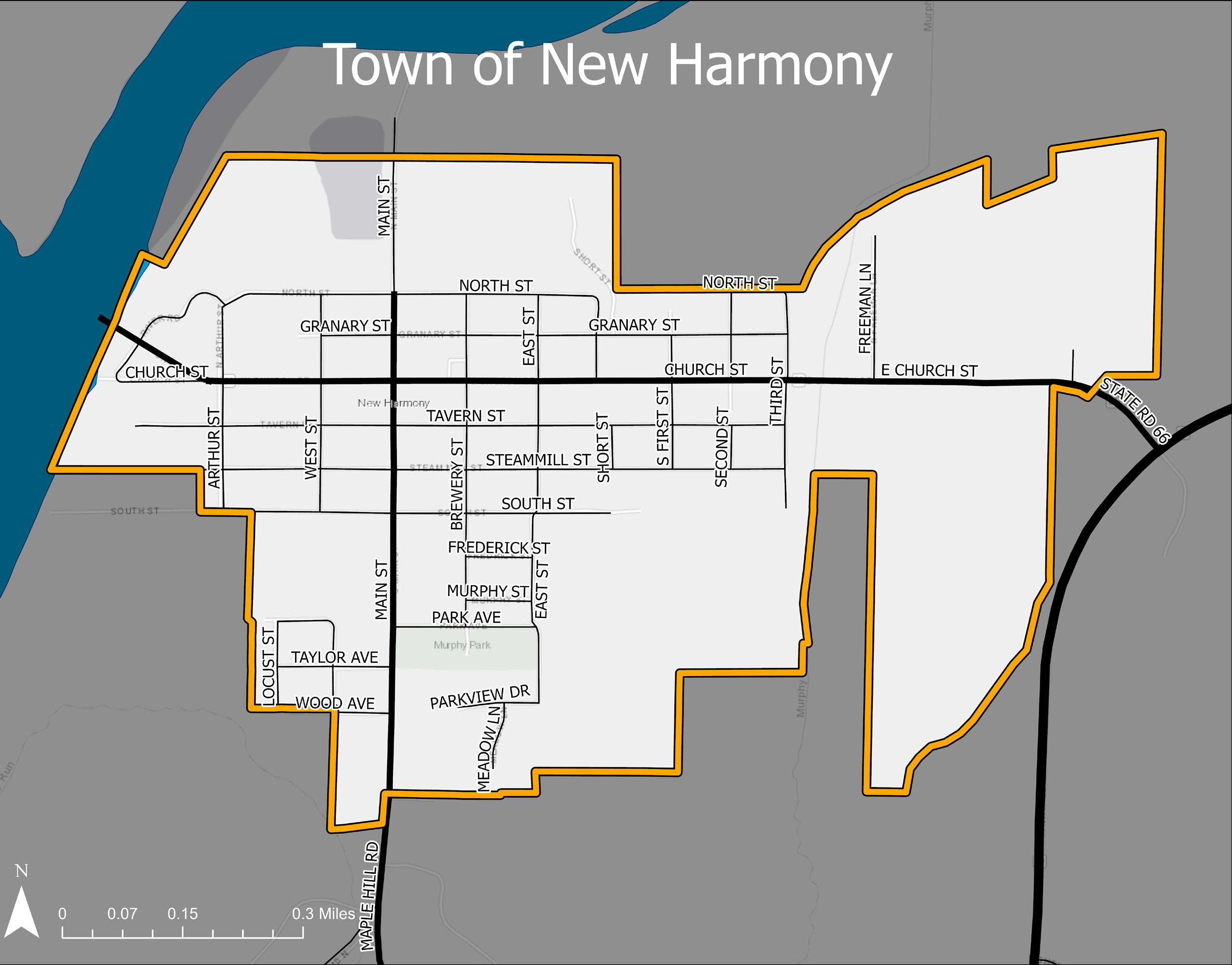
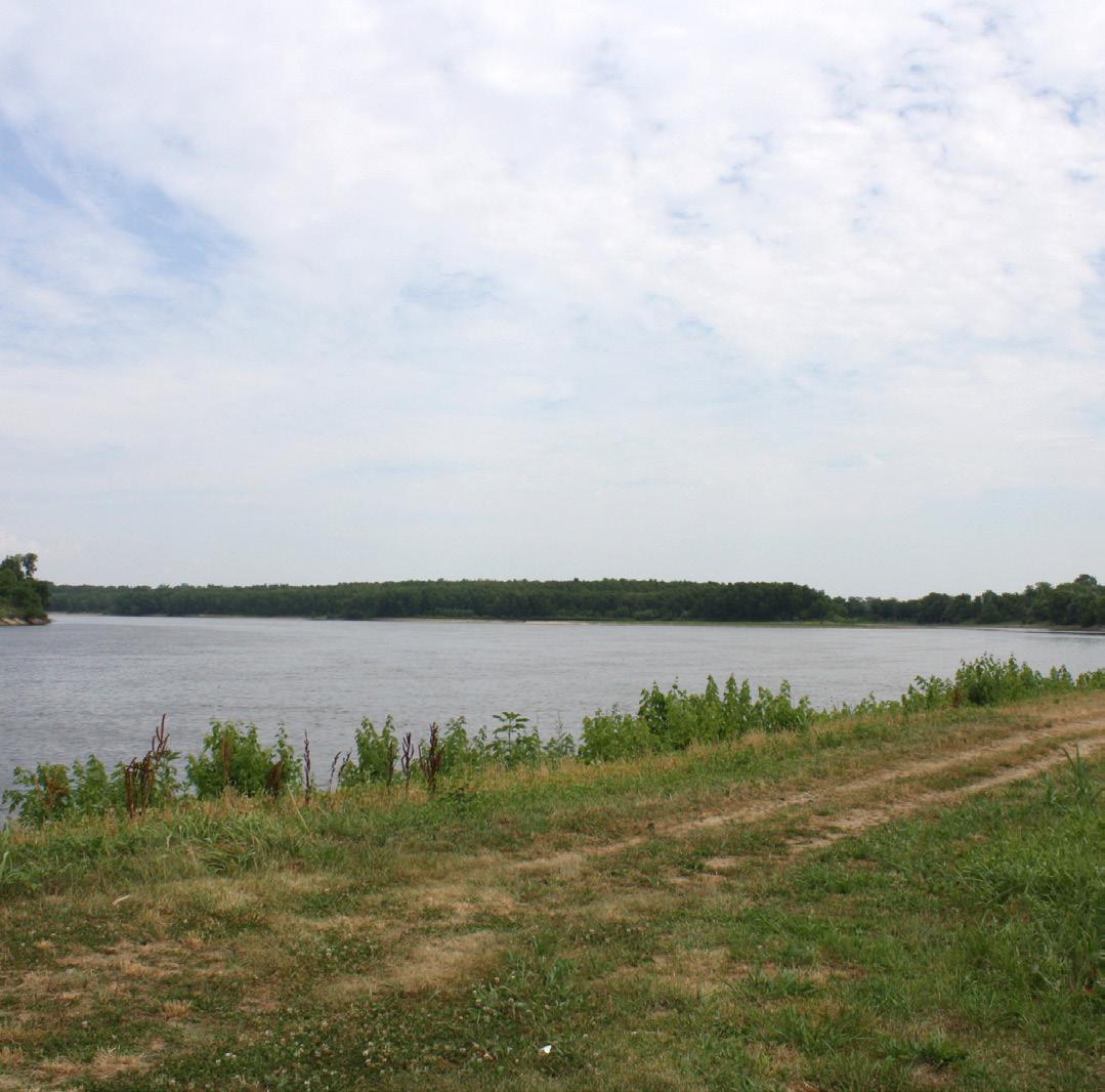
New Harmony is a historic town on the Wabash River in Harmony Township, Posey County, Indiana. It lies 15 miles north of Mount Vernon, the county seat, and is part of the Evansville metropolitan area. The Wabash River forms the western boundary of New Harmony. It is the westernmost settlement in Indiana.
History
New Harmony is the site of two American utopian communities. The Harmony Society, a group of separatists from the German Lutheran Church, founded Harmonie on the Wabash (1814-1824). In 1814, led by their charismatic leader Johann Georg Rapp, they left their first American home, Harmony, Pennsylvania. Indiana’s lower Wabash Valley on the western frontier gave them the opportunity to acquire a much larger tract of land where the Harmonie Society established a well planned town that included 3000 acres of highly cultivated land, including a 18-acre vineyard, a 35-acre orchard of choice apple and pear trees, and a 5-acre vegetable garden. Four large brick dormitories, 15 two-story brick and 25 two-story frame family residences were built in addition to many log cabins which were put up to house the first families coming to the town. As successful manufacturers, the Harmonists also built a steam engine, several mills, two large granaries, wool and cotton factories, a threshing machine, and warehouses and stores that were carefully cataloged in a final inventory of the town that was prepared prior to its sale in 1825 to Robert Owen of New Lanark, Scotland.
Robert Owen’ envisioned the site as a place to test his secular, socialist, and educational theories. World-renowned scientists
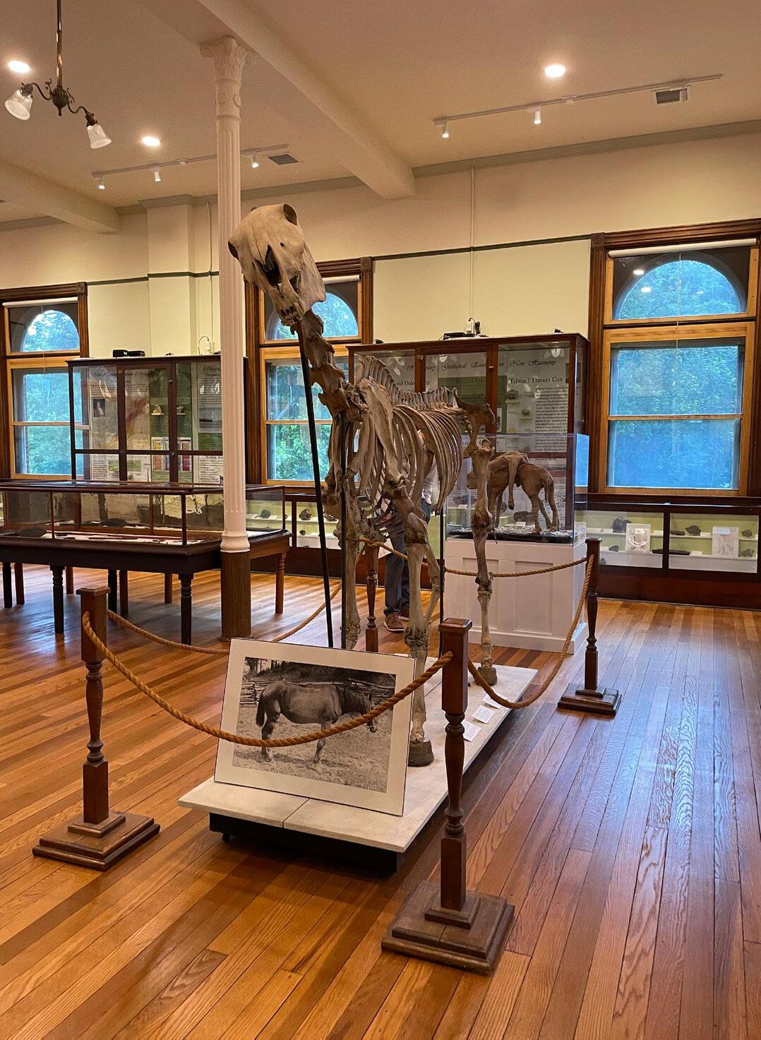
and educators settled in New Harmony. With the help of his partner William Maclure, of the Academy of Natural Sciences in Philadelphia, the Owen/Maclure community introduced educational and social reforms to America. New Harmony’s scientists provided the earliest geological and natural science collections for the beginnings of the Smithsonian Institution. From 1830 until 1860 New Harmony was one of the most important training and research centers for the study of the natural sciences in America.
Many original Harmonist structures remain in New Harmony, along with several Owen/Maclure-era structures. Seventeen structures comprise the National Historic Landmark (NHL) District, as designated by the United States National Park Service (NPS) in 1965. The NHL District was later amended to include the Working Men’s Institute and Murphy Auditorium. In 2001, the National Park Service designated the New Harmony National Register District, which includes most of the incorporated town of New Harmony. The Posey County Interim Report of 2004 details a complete inventory of structures that contribute to New Harmony’s historic district. In 1997, The American Institute of Certified Planners designated New Harmony a National Planning Landmark.
Context
Transportation, architectural assets, and historic assets are important to the context in which New Harmony has developed and exists today.
Wabash River
The Wabash River has served as a vital conduit for trade, travel and settlement in the Midwest for more than two centuries. It is inextricably linked to Indiana’s economy and well-being. The Wabash River is more than 500 miles long and spans the entire state of Indiana. It contains the longest stretch (411 miles) of freeflowing river east of the Mississippi River, with the Roush Dam in Huntington as the division.
In 2018, with funding support from Nestle’ Purina Pet Care, Walton Family Foundation and Enterprise Rent a Car Foundation, The Nature Conservancy established a partnership with Indiana State Department of Agriculture (ISDA) and United States Geological Survey (USGS) to install a super gage at the base of the Wabash River in New Harmony. The super gage, installed and managed by United States Geologic Survey, is continuously collecting water quality information from the river as it exits Indiana and pours into the Ohio River.
Harmony Way Bridge
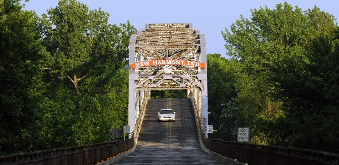
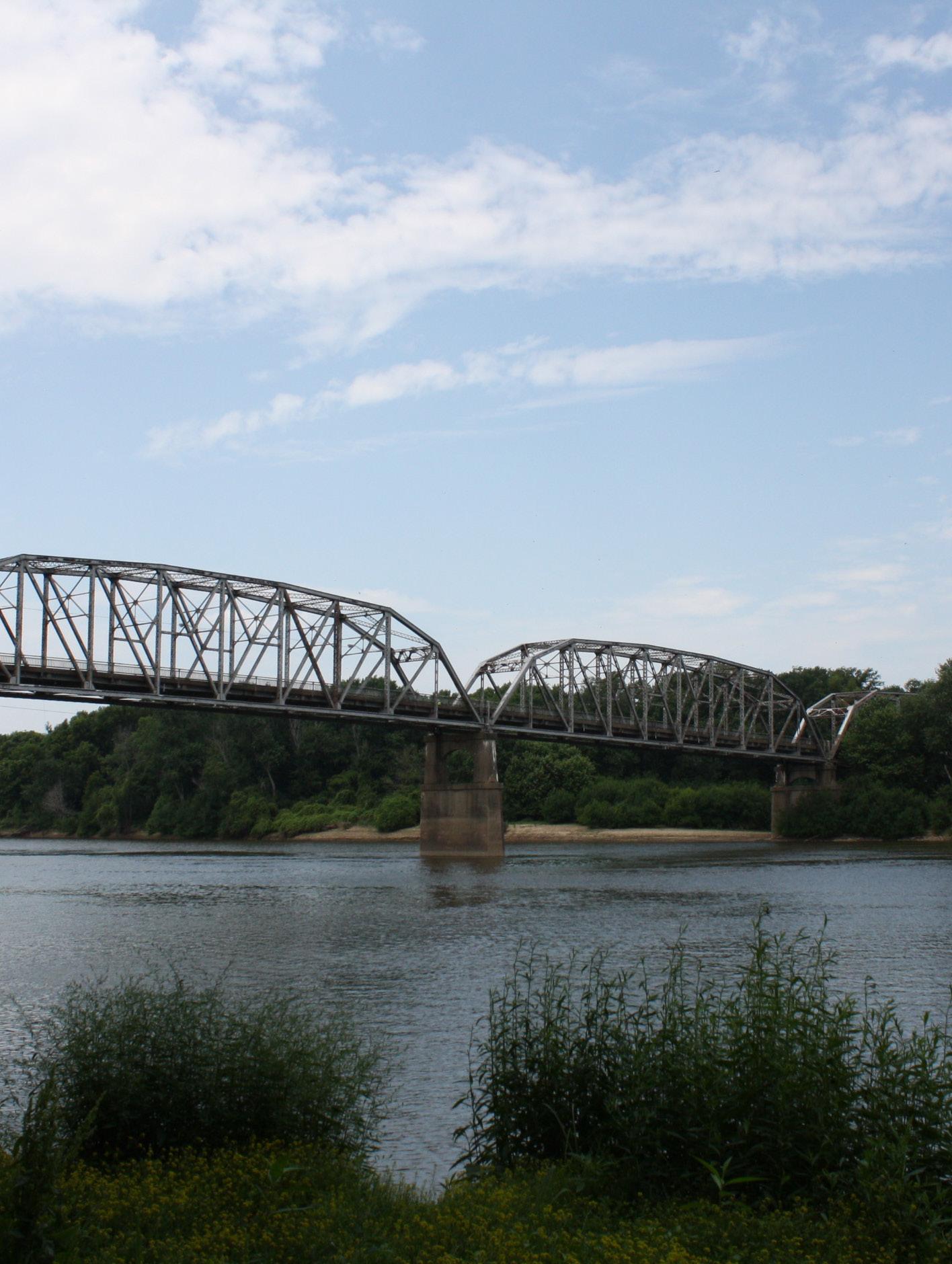
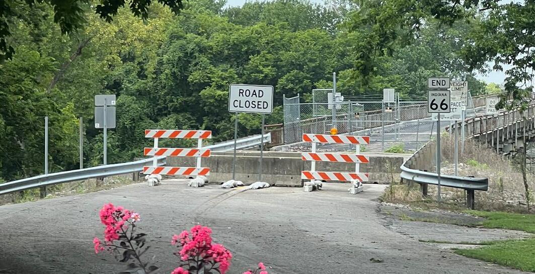
The Harmony Way Bridge, also known as the New Harmony Toll Bridge, served as a connection between White County, Illinois and Posey County, Indiana. The bridge was built by a private firm under charter by the federal government in 1930 and carried U.S. Route 460 from 1947 until the highway was decommissioned in 1974. The Harmony Way bridge is nearly half a mile long and crosses the Wabash River at New Harmony. The federal government took ownership of the bridge in 1941 and established the White County Bridge Commission with the authroity to operate and maintain the bridge. The commission continued to operate the bridge until it was closed in 2012 when the White County Bridge Commission could no longer afford the cost of needed repairs. In 2017, the State of Indiana passed legislation that created the New Harmony and Wabash River Bridge Authority, and the State of Illinois created its own entity called the Illinois New harmony River Bridge Authority. The federal government passed legislation in 2017 to formally pass ownership of Harmony Way Bridge from the federal government (and White County Bridge Commission) to the state entities (joint tenants in common) in February 2018. If and when the bridge is reopened it will connect Church Street (Indiana SR 66) to Illinois Route 14..
State Highways and Interstate Access
Two state roads are located in or near New Harmony. Indiana State Road 66 is also called Church Street in New harmony and ends at the now closed Harmony Way Bridge. Indiana State Road 69 connects New Harmony to Mount Vernon to the south and Interstate 64 at Griffin, Indiana to the north. It is considered a bypass of New Harmony on the eastern side of the community.
Architectural Assets
The architectural style of New Harmony spans two centuries and various aesthetics. Greek Revival, Romanesque Revival, Neoclassical, contemporary, Gothic Revival, Italianate and Federal style architecture are all represented in the town, along with vernacular German housing built by the Harmonists.
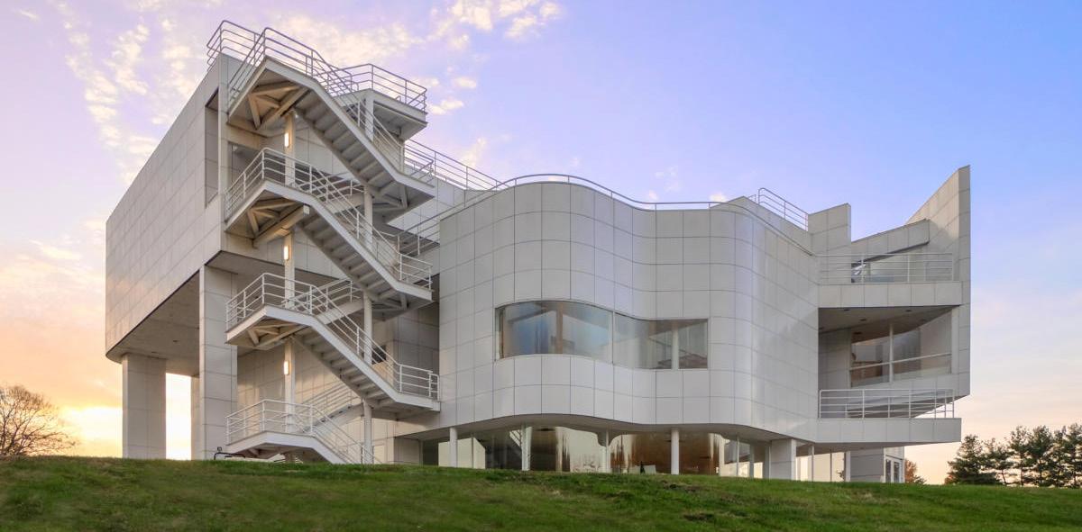
One of the most iconic buildings in New Harmony is The New Harmony Atheneum, built in 1979. The Atheneum was designed by the internationally celebrated architect Richard Meier and has won numerous awards including the Progressive Architecture Award in 1979, and the American Institute of Architects Award in 1982. It was designed as the visitors center for New Harmony and houses exhibits on the history of the town.
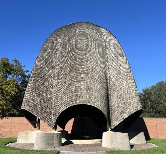
In 1957 Jane Owen engaged architect Philip Johnson to design an inter-denominational place of worship in New Harmony. Completed in 1960 by the Robert Lee Blaffer Foundation, the Roofless Church is situated on the northern edge of New Harmony overlooking the flood plain of the Wabash River. It respects the grid of the Town Plan.
Historical Assets
Of the eighteen listings in Posey County on the National Register of Historic Places , many are in New Harmony. New Harmony was designated a National Historic Landmark District in 1965.
The University of Southern Indiana operates the Historic New Harmony program as a department within their division of Outreach and Engagement. It aims to preserve the history, architecture, and utopian legacy of the town. Historic New Harmony encourages innovation and progressive thought through programs and collections. It aims to further the original founding concepts of New Harmony, being a place of knowledge, collaboration, and community.
COMPREHENSIVE PLAN
According to the Indiana Code 36-7-4 500 Series which enables local units of government to engage in comprehensive planning, comprehensive plans have three required elements.
A. A statement of objectives for the future development of the jurisdiction.
B. A statement of policy for the land use development of the jurisdiction.
C. A statement of policy for the development of public ways, public places, public lands, public structures, and public utilities.
There are optional elements that may be included at the discretion of those forming the comprehensive plan. They may include but are not limited to, parks and recreation, transit, environmental management, education, and redevelopment.
Comprehensive Plan Roadmap/ Addressing the Requirements
The statement of objectives for the future development of the jurisdiction is in Chapter 1 as the Vision and Guiding Principles.
The statement of policy for the land use development of the jurisdiction is in Chapter 2: Land Use, including the Future Land Use Map.
The statement of policy for the development of public ways is in the Chapter 3 Transportation section. The Chapter 3 Utilities and Infrastructure section has the policy for public utilities. The Chapter 3 Recreation and Cultural Assets section establishes the policy for public places, public lands, and public structures.
The plan is divided into chapters:
Chapter 1: Introduction
Chapter 2: Land Use
Chapter 3: Plan Elements
Chapter 4: Implementation
Appendices
The plan elements chapter includes housing, transportation, utilities and infrastructure, recreation and cultural assets, and economic development.
The appendices include definitions, the planning process, public engagement, and the existing conditions report.
VISION AND PRINCIPLES
The vision statement outlines the community’s long-term aspirations. The comprehensive plan sets a vision for 20 years into the future. The vision statement is intended to be read as stating what is true in New Harmony in the year 2045. Elements of the vision statement might already be true today, and that means it is important to preserve and carry forward those elements. The vision and guiding principles were developed from public input and reviewed by the steering committee as well as at a public open house.
Vision
Founded on communal principles, New Harmony is a welcoming and ever-evolving small town, with a resourceful, creative, and innovative spirit. There is a sense of educational, spiritual, and artistic inspiration that thrives. It is a place where history and nuanced ideas meet, where the natural world and human talent connect, and where a sense of community thrives.
Foundational Ideas of the Vision
Connecting Past and Future: The architectural and cultural heritage sites in New Harmony serve as constant reminders of the community’s rich history. The town cherishes its past while intentionally shaping its future – a future where residents continue to engage with their community and experience the beauty of the natural surroundings.
A Welcoming Home: New Harmony residents have opportunities to build fulfilling lives. The community continues to cultivate a welcoming atmosphere and create engaging opportunities for residents of all ages. New Harmony fosters a culture of life-long learning, inclusivity, and collaboration. There is a sense of community where residents connect with neighbors and express their creativity through education, art, volunteerism, and entrepreneurial pursuits.
A Sustainable and Thriving Future: New Harmony has a strong and reliable tourism base that supports diverse businesses and enables the local economy to flourish. Infrastructure improvements strengthen the community’s economic and environmental resiliency while enhancing quality of life.
An Exceptional Place: Collaboration among local institutions protects the many unique assets that distinguish New Harmony as an exceptional place. As a hub for creative and intellectual exchange and with its incredible architecture, artistic spirit, and dedication to preserving its identity, our community is a model of small-town vitality.
Guiding Principles
The guiding principles are the ideas that set the tone for making decisions in New Harmony. They are a framework that cuts across plan elements and guides the future of the community.
1. Protect and enhance New Harmony’s distinctive character, shaped by its unique history, open spaces, natural beauty, and iconic places.
2. Ensure quality development that complements the scale of its surroundings and contributes to the vitality of the community.
3. Provide more housing to support peoples’ needs, focusing on infill housing first.
4. Support, enhance, and foster Main Street and Church Street as the vibrant commercial core of the community.
5. Enhance and cultivate New Harmony as a tourism destination while balancing resident quality of life.
6. Maintain a sense of identity by defining the town’s edges with a transition from residential to agriculture or open space.
7. Preserve quality green spaces, parks, areas of natural beauty, the tree canopy, and agricultural assets that contribute to the town’s serene environment.
8. Pursue mitigation, conservation, and restoration strategies to maintain a resilient community.
9. Upgrade and maintain infrastructure to support the well-being of New Harmony.
10. Ensure the design of public buildings contributes to active streets and public spaces, while being compatible and sensitive to historic architecture.
11. Emphasize active transportation for both destinations and recreation, by connecting land uses through sidewalks and trails.
12. Support educational opportunities in New Harmony.


02
LAND USE
Land use is a foundational element of the comprehensive plan. It describes how land is used across New Harmony, whether for homes, farms, businesses, natural areas, or public spaces, and how these uses relate to one another. Thoughtful land use planning helps preserve what is important, supports development that fits in with its surroundings, and guides infrastructure and service decisions that support sustainable, balanced growth.
While land use does not change zoning or regulate individual properties, it provides a long-term framework that reflects the Town’s goals and values and helps achieve New Harmony’s vision for 2045.
New Harmony was designated as a National Planning Landmark in 1997. From its beginnings as a visionary communal settlement to its present-day role as a hub of arts, culture, and nature, the way land is used reflects the community’s values. This chapter builds on that legacy by outlining a land use approach that protects what makes New Harmony unique, supports residents of all ages, and enhances the Town’s historic and natural assets.
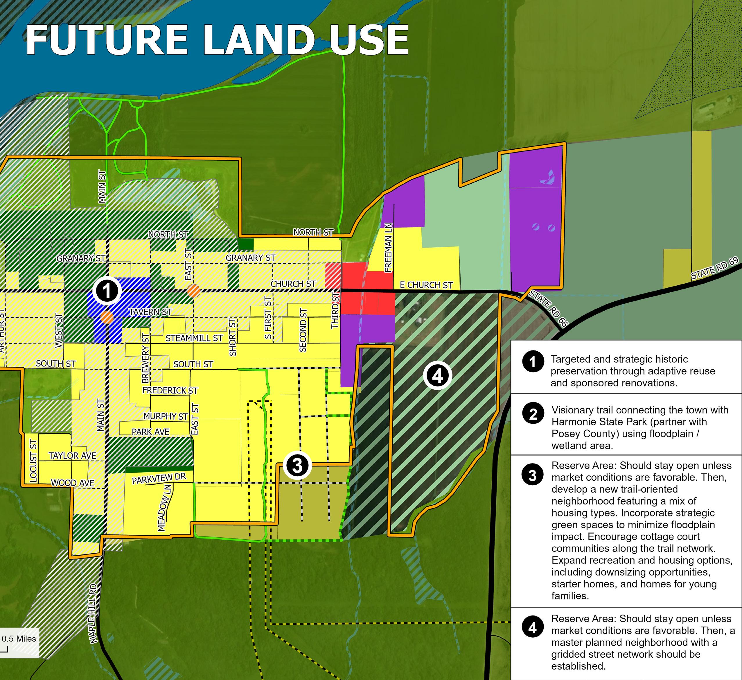
To help guide future decisions, the Comprehensive Plan outlines nine land uses categories:
1. Agricultural (350.3 acres)
2. Conservation (52.1 acres)
3. Residential (244.8 acres)
4. Business (7.9 acres)
5. Light Industrial (18.3 acres)
6. Downtown (8.5 acres)
7. Historic Overlay
8. Future Reserve (92.8 acres)
Each category includes general recommendations on the types of uses, development patterns, and character that are most appropriate. These designations provide a flexible foundation that promotes well-being and supports a cohesive land use pattern that supports the community while reinforcing New Harmony’s strengths.

AGRICULTURE
Agricultural land, the largest land use category, plays a key role in preserving New Harmony’s rural setting, environmental quality, and history. This land use is mainly located in the northeastern corner of town, near the intersection of State Road 66 and State Road 69.
While agriculture remains the primary use, compatible activities such as agritourism and preservation are encouraged. These uses help keep the town’s edges open and connected to its small-town identity.
Recommended Uses
• Crop production and limited non-commerical livestock
• Greenhouses, orchards, and specialty crops
• Preservation or managed open space
• Agricultural accessory units (e.g., barns, silos, farmhouses)
• Agritourism uses (e.g., seasonal farm stands, u-pick farms, educational tours or workshops)
• Historic farm building reuse for events or education, such as farm-to-table events, event venues, educational tours or workshops (permitted with special conditions)
Development Characteristics
• Large, uninterrupted areas for agricultural uses
• Very low-density development patterns—residential uses are limited to those that directly support farming operations
• Buffering of livestock from nearby residential or commercial areas
• Minimal impervious surfaces
• Simple structures reflect rural architecture in style, scale, and materials
CONSERVATION
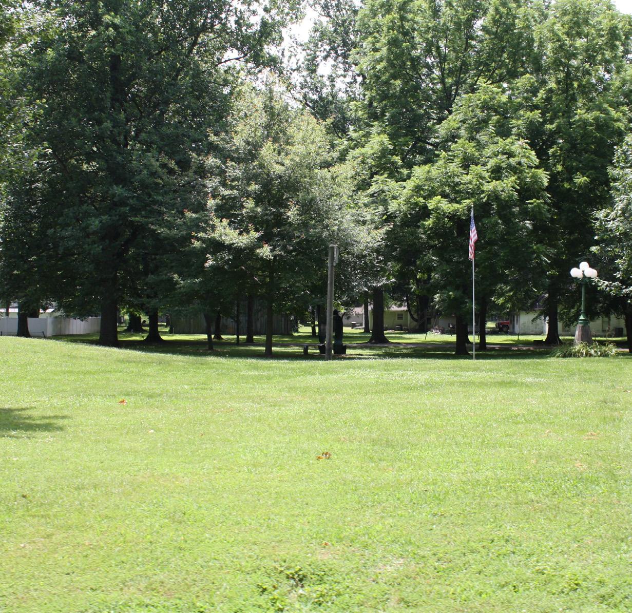
The conservation areas protect and celebrate New Harmony’s most cherished natural and cultural resources. These include parks, historic gardens, and iconic landmarks.
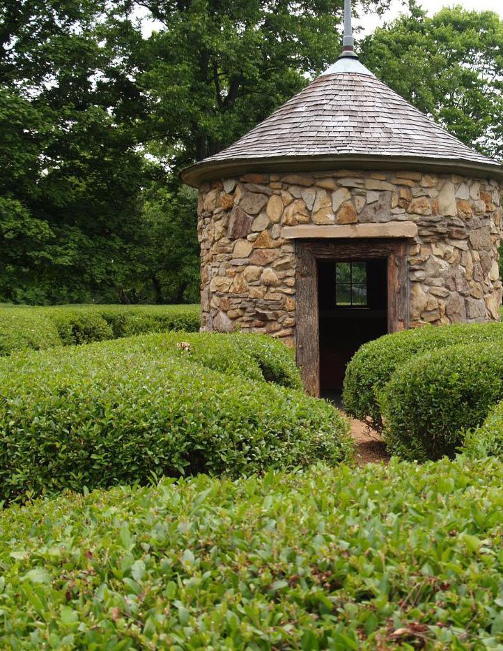
The conservation land use category largely surrounds the downtown core and includes many of New Harmony’s assets, including the Roofless Church, the Cathedral and Harmonist Labyrinths, Murphy Park, and other historic buildings. Conservation areas aim to form serene, open spaces and places that are vital to the town’s sense of place, while encouraging their use in ways that benefit the community.
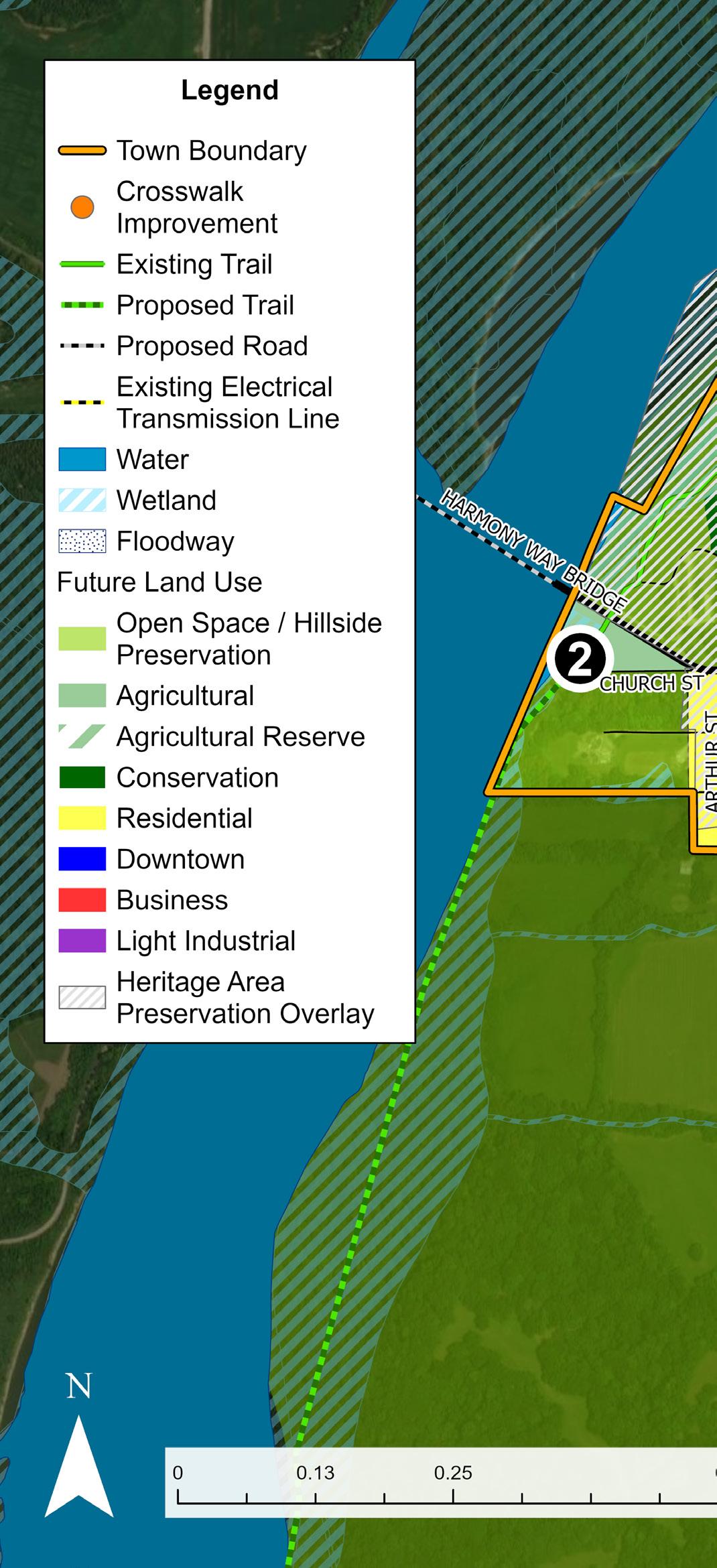
This land use supports long-term goals for environmental stewardship and connectivity. One opportunity is to create a potential trail system connecting New Harmony and Harmonie State Park, potentially in partnership with Posey County. This connection would use the existing floodplain and wetland areas to create a scenic and sustainable recreational amenity for residents and visitors.
Additionally, conservation areas can support compatible community activities, such as small-scale museums, cultural events, or low-impact commercial uses, specifically when these uses activate historic buildings in ways that honor their legacy.
Recommended Uses
• Parks, gardens, and open spaces
• Passive recreation (e.g., walking, birdwatching, meditation)
• Nature trails and scenic overlooks
• Preservation of wetlands, floodplains, and natural habitats
• Historic and cultural landmarks or places of worship
• Museums, inns, or galleries in historic structures
• Environmental or cultural education centers
• Community gardens or low-impact gathering spaces (permitted with special conditions)
• Small-scale, community-serving retail or event uses in historic buildings (permitted with special conditions)
Development Characteristics
• Minimal new development, with land preservation prioritization
• Structures are small, low-impact, and compatible with surroundings
• Infrastructure (e.g., trails, seating, signage) is minimal and maintains the area’s character
• Preservation of existing vegetation, especially mature trees and native plant species
• Lighting is limited, shielded, and preserves the night sky
• Public water fountains are restored and expanded for community use
RESIDENTIAL
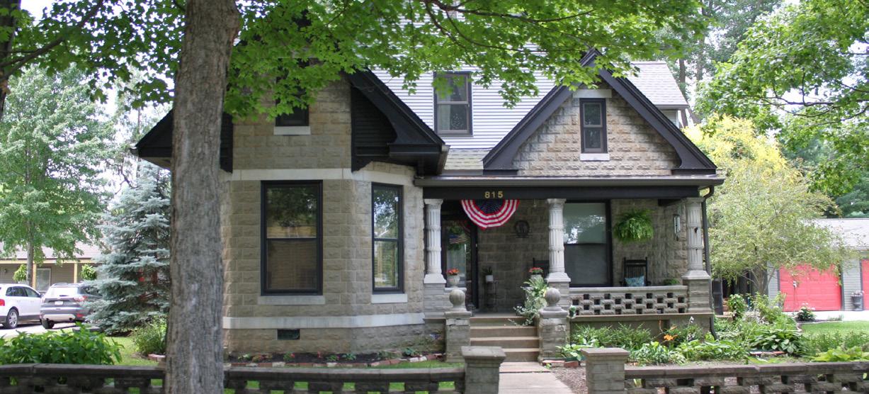
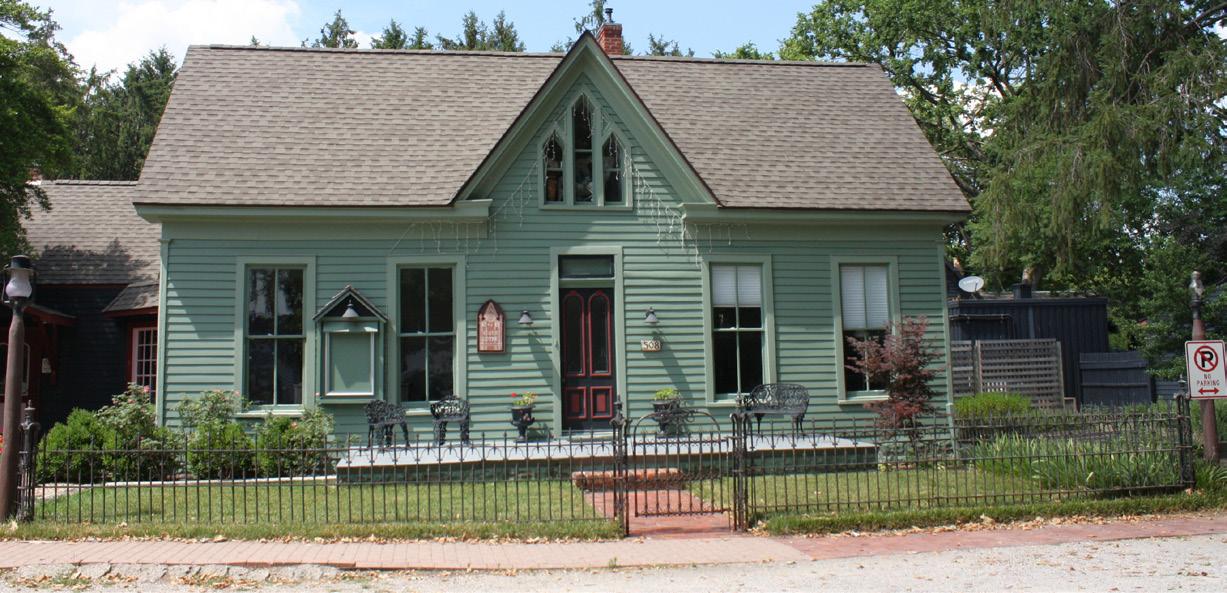
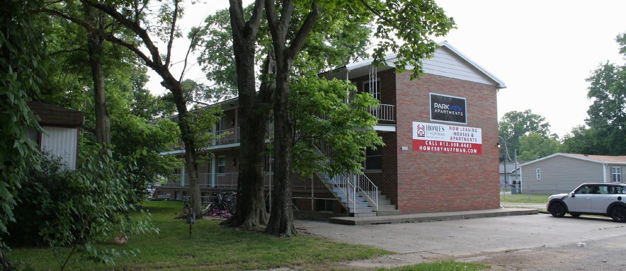
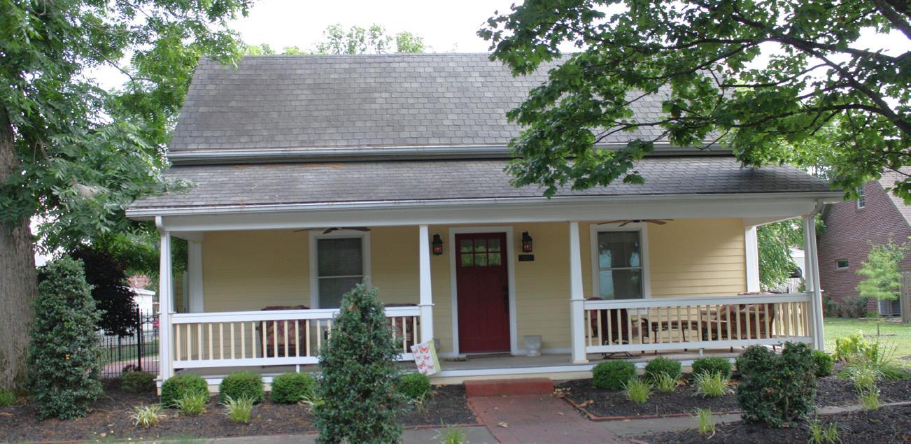
Residential areas offer housing and neighborhood-scale amenities that serve local residents. Residential land use is the second-most prominent category in New Harmony, including mostly single-family homes, but small-scale apartments, duplexes, and mobile homes also exist throughout the community.
This land use supports low-impact housing options that maintain the town’s small-town charm and historic character while providing choices to meet the needs of residents at different stages of life.
Residential land use encourages the preservation of existing homes, thoughtful infill, and context-sensitive new development that complements the surrounding buildings and neighborhood patterns.
Recommended Uses
• Single-family detached homes
• Duplexes and two-family homes (“missing middle” housing)
• Small-scale multi-family housing (e.g., triplexes, fourplexes, cottage courts)
• Single-family “tiny homes” with small footprints and permanent foundations)
• Appropriately detailed manufactured homes of various sizes
• Senior housing
• Accessory dwelling units (ADUs)
• Pocket parks, community gardens, and playgrounds
Development Characteristics
• Infill development is alley-loaded and matches the scale and form of nearby properties
• New neighborhoods should include sidewalks, open space, and connected streets
• Existing residential structures are maintained, with adaptive reuse and minor modifications allowed (minor modifications to be determined in the zoning ordinance)
• Housing types should support affordability and offer diverse options to meet all incomes, ages, and household size needs
• New development should incorporate green infrastructure and native landscaping
BUSINESS
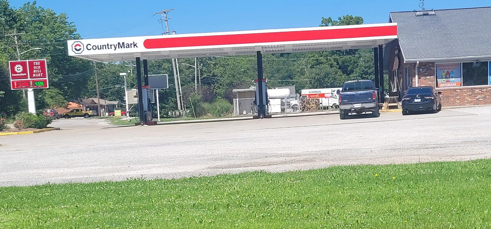
General business areas are where residents and visitors purchase groceries, gas, convenience items, or pick up food from quick-service or carry-out restaurants. It is also an area where services that are not suitable for dfowntown are appropriate. This land use is primarily on Church Street near the east end of town. These businesses are more auto-oriented than downtown businesses and need more consideration for parking, though people may still use other modes of transportation to visit.
Recommended Uses
• General merchandises
• Fast-food, carry-out, or quick-service restaurants
• Professional services and offices
• Public and municipal facilities (e.g., town services, fire stations)
• Health and personal services (e.g., clinics, pharmacies, salons)
• Grocery or speciality food stores
• Gas stations
• Veterinary services
Development Characteristics
• Parking may be located in front of the building but is screened from the street and adjacent properties
• Signs minimize visual clutter at the town gateway
• Sidewalks are provided for pedestrian use
• Lighting should not spill onto the street or adjacent properties
LIGHT INDUSTRIAL
The light industrial land use supports small-scale manufacturing, production, utilities, and distribution. These areas are located on the eastern edge of town and should be designed and operated to minimize their negative effects on the environment, nearby neighborhoods, and the overall community character.
Light industrial areas provide space for local jobs, creative industries, and essential services and infrastructure while maintaining a scale and appearance that respects nearby residential and natural areas.
Light industrial areas should support the continued operation of existing facilities, especially when upgrades are made to improve building resiliency. Older or underused sites may be redeveloped into small-scale, community-oriented industrial spaces. New development should focus on low-impact industries that add to the town’s economic vitality while remaining compatible with the surrounding context.
Recommended Uses
• Light manufacturing and assembly
• Warehousing and distribution
• Artisan and craft production (e.g., printmaking, small-bath manufacturing, creative or makers studios)
• Food production or packaging
• Green and sustainable industries (e.g., composting operations, plant nurseries, solar installation offices)
• Construction support businesses
• Repair services
• Small-scale warehousing or storage
Development Characteristics
• Operations must be low-impact and not produce significant noise, odor, or pollution (e.g., light, environmental, air)
• Site layouts have adequate buffering from residential and natural areas through landscaping or setbacks
• Outdoor storage should be well-kept and visually unobtrusive or screened from public view
• Buildings should be modest in scale and designed to fit the surrounding context
• New development or redevelopments should incorporate stormwater best practices and minimize impervious surfaces where possible
• Signage and lighting should be functional, minimal, or compatible with historic character
DOWNTOWN
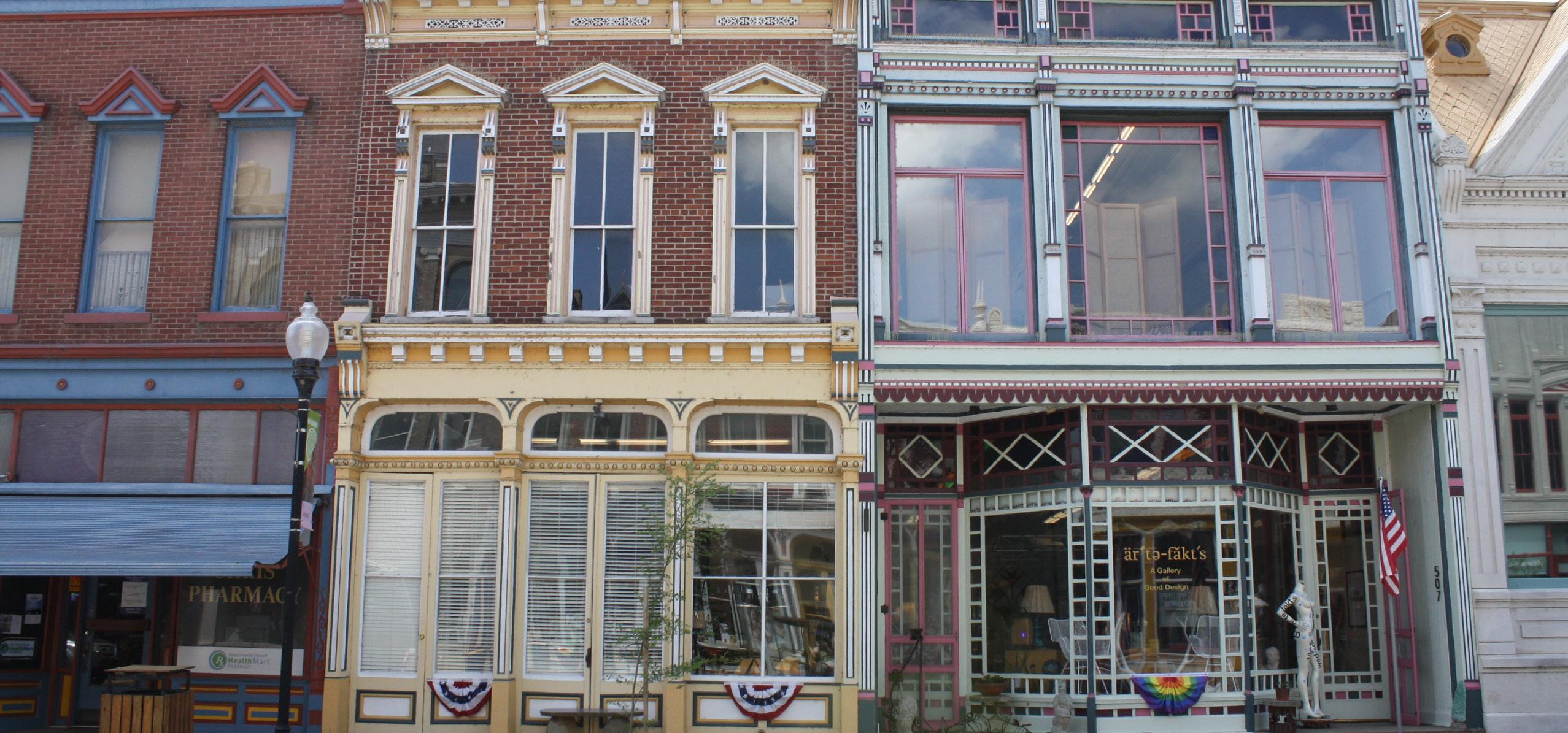
Downtown New Harmony is near the intersection of Church Street and Main Street. It is a compact, walkable area that brings together civic life, local commerce, and tourism. Downtown is one of the town’s gathering spaces. It is known for its well-preserved architecture and is defined by its human-scale streetscape. It serves as a destination for visitors while providing a vital space for residents’ everyday life and community connection.
The downtown land use category encourages a mix of uses that reflect its established character while supporting continued vitality through adaptive reuse, strategic preservation, and sensitive infill. Renovation efforts should celebrate and maintain the architectural integrity of the historic commercial core while enabling buildings to evolve for modern needs. Adaptive reuse of older buildings, paired with programs or incentives that support restoration, can help New Harmony retain its unique identity and ensure downtown remains an active, inviting, and economically resilient place.
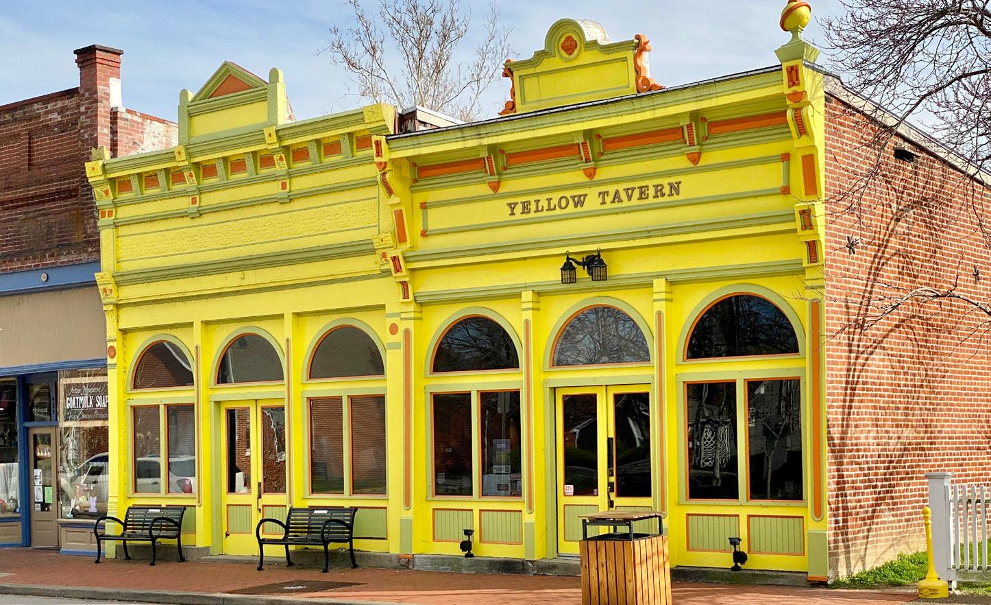
Downtown currently includes various uses such as retail shops, restaurants, cafes, museums and cultural destinations, government buildings, professional services, a florist, a winery and tavern, an event venue, banks, a post office, a local newspaper publisher, and more. Future land use should continue to support this diversity of activities.
Recommended Uses
• Retail shops and dining
• Art galleries, museums, and cultural venues
• Office and professional services
• Civic uses (e.g., plazas, meeting spaces, government buildings)
• Small-scale residential located above ground-floor commercial uses
• Community-serving businesses (e.g., pharmacies, financial services)
• Event and performance spaces
• Boutique inns or guest accommodations
• Educational facilities or research space
Development Characteristics
• Preserve historic buildings through sensitive renovations and adaptive reuse
• Encourage infill that complements the surrounding character and scale
• Street-level spaces are active and inviting
• Signage, storefront, and lighting should reflect the area’s identity
• Use upper floors for residential, office, or creative space
• Improve pedestrian amenities (e.g., seating, plazas, water fountains, restrooms, gathering spaces)
• Improve walkability and connections to trails, parks, and neighborhoods
FUTURE RESERVE
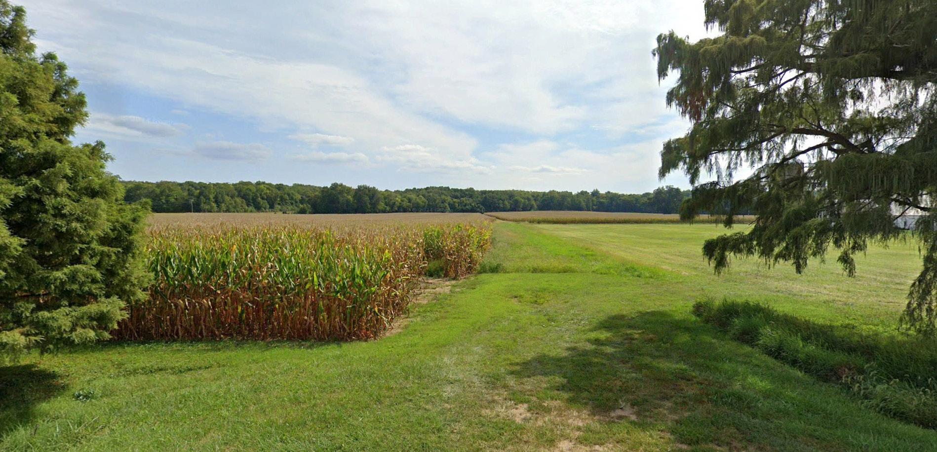
The Future Reserve area is approximately 62 acres at the southeastern edge of town (south of East Church Street and Freeman Lane). This land is not currently needed for development but is set aside for potential long-term growth.
At this time, the land should remain undeveloped and may continue to be used as agricultural or open space. However, if demands increase in the future, this area may be reconsidered for development. Any future development within this area should reflect New Harmony’s values of scale, community connectivity, and walkability. New neighborhoods should be planned comprehensively, rather than parcel by parcel, with a walkable street grid and housing.
Recommended Uses
• Future residential development, including a mix of small-scale housing types
• Neighborhood-serving amenities such as small parks, trails, or shared green spaces
• Preservation of natural features and open space until development occurs
Development Characteristics
• Development should only occur when demand and infrastructure capacity support it
• A master-planned neighborhood approach is encouraged
• Streets should connect surrounding areas and support walkability
• Housing should reflect New Harmony’s small-town character
• Open space and natural features should be preserved or integrated into neighborhood design

HERITAGE AREA PRESERVATION OVERLAY
The Heritage Area Preservation Overlay is not a separate land use category, instead acting as a layer of additional guidance applied to other land uses within the district, such as downtown, conservation, business, and residential, and mirrors the National Register of Historic Places District. Within this overlay (to be developed), preservation and adaptive reuse of historic buildings is strongly encouraged, and any new construction should complement the scale, materials, and character of its surroundings.
Key Considerations
• Complies with National Register of Historic Places and Indiana Division of Historic Preservation standards as appropriate for contributing buildings and resources
• Encourages the maintenance and sensitive reuse of historic buildings
• Supports architectural integrity, high-quality materials, and traditional building patterns
• Promotes context-sensitive infill that contributes to the existing area
GOAL AND POLICIES
Goal: Ensure development and redevelopment projects are consistent with the town’s existing character.
Policies:
1. Maintain the existing grid pattern for new development.
2. Prioritize and encourage infill development or redevelopment
3. Encourage non-residential development that meets local needs and attracts tourists.
4. New business development is intended to support residents’ needs while increasing tourism spending.
5. Home-based businesses are encouraged
6. New industrial development should locate near existing similar development and consider how truck traffic impacts other road users.
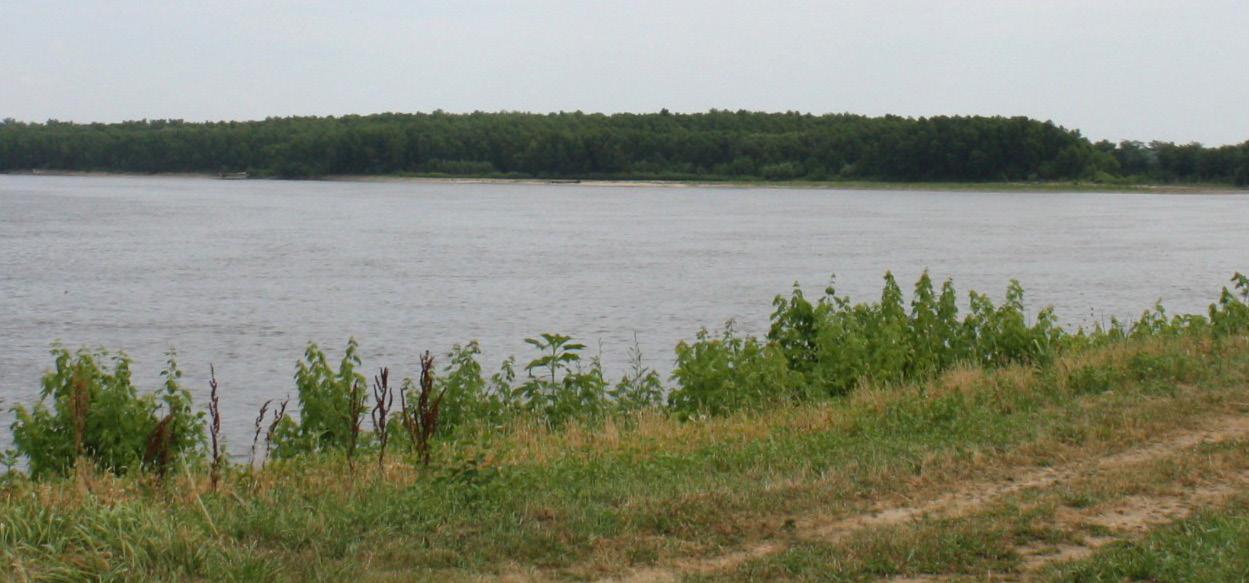
7. Protect natural areas and activate the riverfront.
8. Support agricultural businesses and tourism.
9. Encourage adaptive reuse and sponsored renovations of historic buildings.
This page was intentionally left blank.

03 PLAN ELEMENTS
The plan elements consider housing, transportation, utilities and infrastructure, recreation and cultural assets, and economic development in greater detail.
HOUSING
New Harmony’s housing reflects its small-town charm and historic character, but future growth must be approached with care. A thoughtful mix of infill, redevelopment, and new development can support community needs while preserving the town’s unique identity.
Infill Housing
Infill development offers an opportunity for New Harmony to grow in a way that complements its existing character. Vacant or underused lots within established neighborhoods can be repurposed for housing that fits the town’s scale and character. Infill also makes efficient use of existing infrastructure—like streets and utilities—and supports walkability by placing homes closer to community amenities.
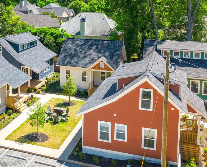
Encouraging infill housing types such as cottage courts , singlefamily homes, and accessory dwellings allows the town to meet housing demand while preserving its unique identity. Cottage court homes are a type of “missing middle” housing that is intended to serve the market for households between 80 and 100 percent of area median income that are seeking housing that is attainable, spending less than 30 percent of their household income on housing. Missing middle housing is also a range of housing types including duplexes, triplexes, townhouse (row houses) and smaller apartment buildings (as well as conversion of single-family homes to multiple units) that fit between singlefamily housing and larger apartment buildings with 10 or more units. This is market rate housing made affordable by smaller sizes and efficiency of land use.
Cottage court homes can fit on one or two standard residential lots and serve multiple households while still providing individual living spaces or entryways.
Accessory dwelling units are sometimes called “mother-in-law units” or “granny flats” and are smaller homes than the primary residence, but located on the same lot, and allow for more affordable housing that still has privacy for young adults, older adults, or people who need care by a family member. In some cases, they could be rented out to non-related individuals to provide additional income.
Redevelopment
Redevelopment focuses on revitalizing older or underperforming residential areas. In New Harmony, this may include improving housing conditions, replacing dilapidated structures, or converting underutilized properties into vibrant housing opportunities. Redevelopment efforts should be sensitive to the surrounding historic fabric and should aim to improve the livability and longevity of neighborhoods without compromising their character.
Through strategic partnerships and design review processes, redevelopment can serve as a tool to address housing needs while enhancing the aesthetic and cultural value of the community. Prioritizing walkable, connected neighborhoods ensures that redevelopment contributes positively to the broader town framework.
The former school site was recently sold to a developer who may be interested in building housing on the site. This could be a significant redevelopment project occurring in the town.
Small scale redevelopment opportunities should consider some of the same housing types as infill development.
New Development
New housing development could be needed to accommodate future population growth and ensure that a diverse range of residents can call New Harmony home. While growth will be modest, it must be thoughtful and aligned with the town’s values. New neighborhoods should reflect the scale, block pattern, and connectivity of traditional development in New Harmony.
Demographic trends in the community (see the existing conditions report) reflect broader age and gender trends in the community and highlight the need for housing options that support smaller households, aging residents, and a range of family structures.
New neighborhoods should connect to the existing street and sidewalk network, supporting community cohesion and walkability. Where appropriate, small-scale multi-family housing can provide additional options, as long as it remains compatible with neighborhood character.
Goals and Policies
Goal: Maintain the character of neighborhoods in New Harmony while inviting unique and interesting design.
Policies:
1. Support single-family development, cottage court housing, and accessory dwellings.
2. Establish dimensional standards (lot width/ depth, building height, lot coverage) for development, both infill and new development, that maintain the housing pattern.
3. Require new neighborhoods to connect to the existing neighborhood street and sidewalk network.
4. Require development plan review for multifamily development.
5. Ensure that new multi-family development is at a scale that is compatible with the surrounding character of the neighborhood.
TRANSPORTATION
Transportation is the networks that allow people to move between destinations in the community, in the region, and access the rest of the state, country, and world. Transportation modes and networks change over time based on new technologies or the cost of maintaining old technologies or modes in a particular location. Some of the infrastructure of older modes can be converted to support newer modes. In New Harmony’s early years the Wabash River played a significant role, bringing people and goods to the community. Now it is primarily not used for boat navigation, but as a recreational asset. State highway routes may be replaced with interstate highways to more efficiently move people and goods throughout the region. Passenger boats and passenger rail have been largely replaced by air travel. Golf carts have become a local transportation option.
State Highways
Moving most of the vehicular traffic in Posey County, state highways such as State Road 69, also known as New Harmony Bypass, and State Road 66, also known as Church Street, play an important role in bringing residents and tourists to the town. They also play an important role in enhancing the town’s visibility to travelers with signage and landmarks. The town’s visibility is especially important because:
1. The town only sits about 2,000 feet away from SR 69 but is almost completely hidden by trees
2. The Harmony Way Bridge has been closed for years, making Interstate 64 over the Wabash River into Illinois the primary route
3. There are few landmarks or signs indicating how to get to New Harmony from the state highway network
4. Higher visibility can better promote and attract people to the town’s local shops and attractions.
The state highways are owned and maintained by the Indiana Department of Transportation (INDOT) and the town can provide input to changes on state roads, but does not control their access, maintenance, design, or use.
State regulations also prohibit the use of golf carts, a major form of local transportation, on state highways. This regulation lowers the mobility of residents and visitors, who instead use local side streets and alleys to avoid SR 66.
Heavy trucks are permitted on Church Street per INDOT regulation.
Harmony Way Bridge
The Harmony Way Bridge is an integral part of local, state, and national history, becoming part of the National Register of Historic Places in 2007. It was developed by a private entity and was originally a toll bridge. Later, the federal government established an independent commission that was responsible for the bridge maintenance and tolling. It has been closed since 2012. Recently both Indiana and Illinois have created their own commissions that jointly own the bridge. They are currently conducting engineering, environmental, and other studies necessary before the bridge can be repaired. Their legislative mandate dictates reopening the bridge to at least one lane of traffic The authories are exploring options for bicycles and pedestrians.
The bridge carries important utility lines (gas and fiber optic internet services). If the bridge cannot be restored to traffic use or would need to be demolished, an alternate means of routing those utilities would need to be developed.
Residents have expressed interest in having the bridge reopened to bicycle and pedestrian use, however the engineering standards for those uses are the same as for vehicle use.
Local Roads and Streets
All other streets can be characterized as neighborhood-level streets, meaning there is little to no vehicular traffic, very little through-traffic, four-way stops, and low vehicle speeds.
Streets are used by vehicles, motorcycles, golf carts, bicycles, and pedestrians.
Intersections
Main and Church Streets form the main intersection of the town. The town’s historic business district radiates out from this intersection. There are no signalized intersections in town and four-way stops are common on neighborhood streets and Main Street. There are only two stops for vehicular traffic on Church Street — the intersection with Main Street and the intersection with SR 69. Designated pedestrian crossings are found at the intersections of Church/Main Streets, Church/Brewery Streets, and Main/Steam Mill Streets. Any new crosswalks on Church Street must be approved by the Indiana Department of Transportation (INDOT) since it is owned by the state.
Crosswalk improvements are recommended at Church and East Street and at Main and Tavern Streets. The town is working with INDOT on the Church Street intersection design.
These intersections see relatively high pedestrian traffic since there are nearby businesses and amenities that people use these streets to access. Crosswalk improvements make it safer for people to cross the street by improving the visibility of pedestrians to drivers and visually signaling drivers to pay extra attention since pedestrians frequently cross the street there. These crosswalk improvements could include curb bump-outs to reduce crossing distances, or painted crossings.
Sidewalks
Most sidewalks in town need repairs, especially in order to comply with the Americans with Disabilities Act (ADA) accessibility regulations. Because of low traffic volumes and speed residents and visitors alike find walking on the street is just as, if not more

comfortable, than walking on a sidewalk. The exception to this is Church Street, which carries the majority of vehicular traffic into and out of town. Sidewalks along Church Street are mostly in fair to poor condition and comply with ADA regulations. However, curb cuts for the town’s post office parking lot, located on the west side of the building, do not have ADA accessibility. While the ADA standards for sidewalks are the current standard, the federal government is in the process of considering new guidelines known as Public Right-of-Way Accessibility Guidelines (PROWAG). If adopted by the US Department of Justice and the US Department of Transportation , the PROWAG standards will be required in new projects.
The town’s sidewalk ordinance requires property owners to construct and maintain their own sidewalks. To improve the sidewalks in a timely and cost-effective manner the town should consider use of economic development funds for sidewalk maintenance and new segments or develop a cost share program with property owners.
Trails
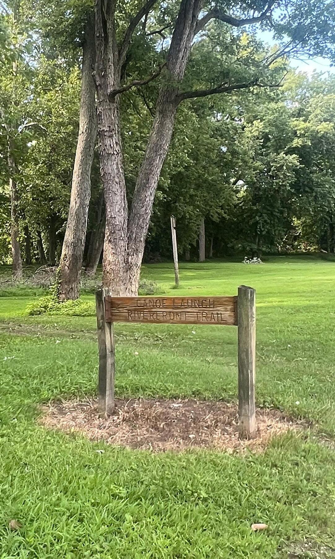
The town has several gravel trails that connect many of its riverfront amenities and northern-most attractions, including the Atheneum (Visitors Center), Roofless Church, New Harmony Inn, MacLeod Barn Abbey, and a canoe launch. There is also a gravel trail on the southern edge of town, looping around the former school on East Street. The trail utilizes easements for electrical lines, land which would otherwise have limited development potential.
Goals and Policies
Goal: Prioritize multiple transportation options in town, providing safe and convenient travel for all road users including passenger vehicles, delivery vehicles, golf carts, bicycles, and pedestrians.
Policies
1. Continue to restrict non-delivery semitractor trailers, except those needed for construction to state routes.
2. Increase the availability of bike racks at locations that experience a significant number of visits by bike as the need develops.
3. Maintain and improve existing sidewalks.
4. Continue to require sidewalks for new development.
5. Reopen Harmony Way Bridge to traffic that includes bicycles and pedestrians. Vehicle traffic will be involved as part of the legislative mandate from both Indiana and Illinois.
6. Partner with Posey County and the Indiana DNR to expand the trail network to connect the town to Harmonie State Park.
UTILITIES AND INFRASTRUCTURE
Utilities include both public and private services for gas, electricity, water and wastewater (sewer), telecommunications, and solid waste management/recycling.
Gas
New Harmony has a municipal gas utility. The New Harmony Gas & Street Superintendent is the department responsible for natural gas emergencies. The town council has general supervisory powers over the gas utility per town ordinances.The gas mains generally run along the town’s street grid, with most lines running along the east-west streets.
Electricity
Electricity in New Harmony is provided by CenterPoint Energy. The town has an Electric Substation north of the former school off South Street. The electricity utility is a private company.
Water and Wastewater
The Town of New Harmony operates a wastewater and water department, New Harmony Water Works. The town’s water infrastructure generally follows the existing street grid. Service also extends south and east of the town boundary.
The New Harmony Sewage Treatment facility is located off Tavern Street on the west side of town. Wastewater and stormwater lines generally follow the existing street grid.
Telecommunications
Land line phone service is provided by AT&T. New Harmony has two internet providers: AT&T and Sparklight. According to the Federal Communications Commission, most locations in New Harmony have access to broadband.
In surveys, visitors expressed that they were unable to get adequate cell service coverage in the community and recommended town-wide wifi. New Harmony recently received a grant to expand data service downtown and will provide public wifi downtown.
Solid Waste Management/ Recycling
New Harmony provides residential trash collection for a monthly fee paid to the sewage utility.
The New Harmony Recycling Center located on East South Street is operated by the Posey County Solid Waste District. Collected materials are brought to the Mt. Vernon Recycling Center for processing and shipping.
Goals and Policies
Goal: Ensure New Harmony residents and businesses have clean water and wellmaintained sewage and drainage systems.
Policies
1. Continue to monitor federal guidance on water quality
2. Monitor the needs for upgraded and expanded wastewater treatment.
3. Monitor the needs for drainage and stormwater improvements.
RECREATION AND CULTURAL ASSETS
With its unique location, foundation story, and history, New Harmony has recreation and cultural assets that would be significant for any community and are particularly important for a small town in terms of opportunities for residents, ability to attract new residents, and tourist visits and spending.
Key stakeholders in the preservation and management of New Harmony’s historical and cultural properties include the Blaffer Foundation, the University of Southern Indiana’s Historic New Harmony initiative, the Indiana State Museum and Historic Sites, the Rapp-Owen Granary Foundation, and the Owen Maclure Foundation. The assest described in this chapter are not an exhaustive list of the cultural assets, historical assets, and historic buildings in New Harmony.
One New Harmony
One New Harmony is the Indiana Main Street Organization for New Harmony and they market the community under “Visit New Harmony.” One New Harmony was formed in 2022 to expand on the New Harmony Business Associates group established in 1981 to promote the town. The organization focuses on day visitors to New Harmony, partnering with Visit Posey County for marketing to overnight visitors.
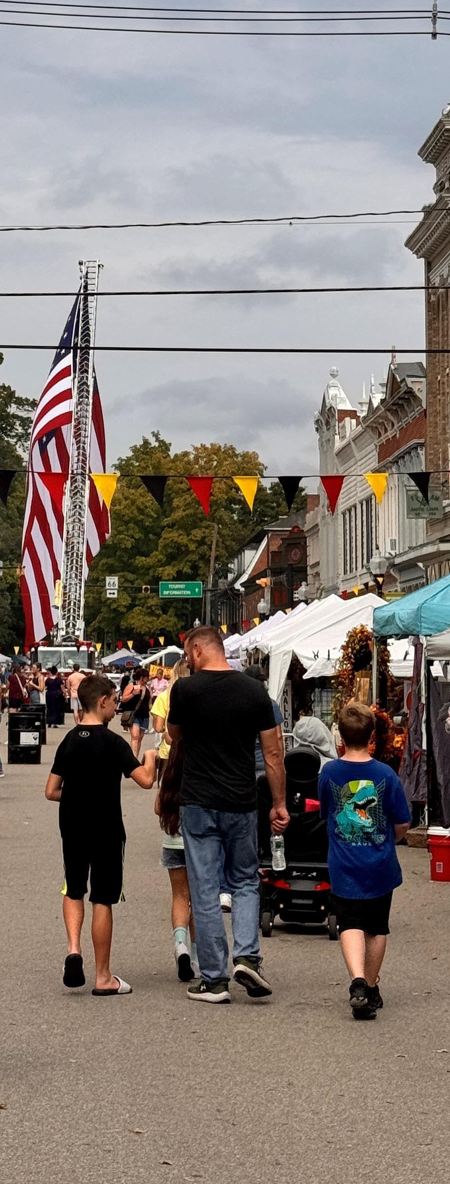
The organization also hosts and coordinates events like Arts in Harmony, Kunstfest, Christmas in New Harmony, the Firefly Festival, and Antique Show.
Visit Posey County
Visit Posey County is funded with the Innkeeper’s Tax and their primary responsibility for marketing in Posey County, including New Harmony, is reaching overnight guests.
Their marketing efforts included experiences focused on local eating and drinking places, exploration and recreation, weddings, and resort/conference events. Their website promotes the town for various visits such as weddings, honeymoons and anniversaries; business meetings; family reunions; and renewal.
State of Indiana managed assets
The Indiana State Museum and Historic Sites plays a major role in the ownership and preservation of New Harmony’s historic properties. As part of the Indiana state government’s historic site system, the museum manages several important properties in the town, ensuring their preservation and accessibility.
The museum’s role in New Harmony is crucial to maintaining the town’s position as a historical and cultural destination. By preserving these properties, the museum ensures that the town’s unique architectural and social history remains accessible to the public.
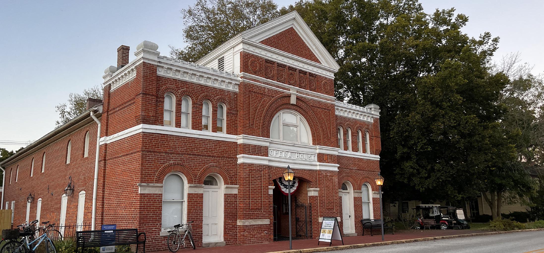
Thrall’s Opera House
The Harmonist’s Community House Number 4, the last of their major building projects before leaving New Harmony, was used as an automobile mechanic’s shop in the early 1900s. The owners kept the building from falling into disrepair. In 1964 the Indiana Department of Conservation purchased it and restored the exterior. In the late 1960s it was restored on the interior to its opera house period. The opera house period had been from the mid to late 1800s.
Native American Burial Mounds and Harmonist Cemetery
Eight Native American burial mounds are located within the later brick-walled cemetery in northwest New Harmony. The Harmonists used the space around the mounds as a cemetery shortly after their arrival in 1814. During the first year, many Harmonists died of malaria and were buried in unmarked graves.
Harmonie State Park
While outside the town, the Harmonie State Park spans over 3,400 acres of protected land, including wetlands, forests, and prairie. The park offers camping, hiking trails, picnic areas, and opportunities for birdwatching,;providing a space for visitors to connect with nature while exploring the town’s scenic landscape.
Community House No. 2
Community House Number 2 appears much the same as it did when used as a Harmonist dormitory. This was the largest of the four community homes. The State of Indiana purchased the building in 1940 and it is now owned and managed by the Indiana State Museum and Historic Sites.
University of Southern Indiana managed assets
The University of Southern Indiana (USI) is another key stakeholder in the ownership and management of properties in New Harmony. Through its Historic New Harmony initiative, USI works to preserve the town’s historical assets while promoting education and community engagement.
USI’s involvement in New Harmony is centered around educational outreach, connecting its faculty, students, and the general public to the town’s historical and cultural legacy. This initiative also promotes scholarly research into New Harmony’s role in the development of American utopianism and social reform.
The Atheneum
Designed by Richard Meier, the Atheneum serves as the visitor center for New Harmony. This building offers interpretive exhibits, guided tours, and educational resources that explore the town’s unique history. As a modern architectural landmark, the Atheneum is a focal point for tourism and learning.
The New Harmony Gallery of Contemporary Art
Founded in 1975, the New Harmony Gallery of Contemporary Art showcases works by both local and national artists, providing a platform for emerging talent while contributing to the town’s thriving arts scene. The gallery hosts rotating exhibitions, offering visitors a constantly evolving experience of contemporary visual arts.
Blaffer Foundation
The Robert Lee Blaffer Foundation plays a significant role in New Harmony, focusing on the preservation of its historic structures and landscapes. The Owen Maclure Foundation is a philanthropic organization with deep ties to the historical legacy of Robert Owen and his descendants. Although the Owen family no longer directly owns much of the property in New Harmony, the foundation continues to play a role in supporting the preservation of the town’s historical heritage and in promoting educational and cultural initiatives.
The Roofless Church
One of the most iconic landmarks in New Harmony, the Roofless Church was designed by renowned architect Philip Johnson. The Blaffer Foundation owns and maintains this outdoor sanctuary, symbolizing a space of spiritual openness. The church is not only a religious and spiritual site but also an architectural masterpiece, attracting visitors from around the world.
The Rapp-Owen Granary
Originally built by the Harmonists and later used by Robert Owen’s community, the Rapp-Owen Granary is one of New Harmony’s most historically significant structures. Rapp-Owen Granary Foundation has been instrumental in the restoration efforts of the Granary and supports its use as a venue for events, educational programs, and exhibitions.
William Maclure used the granary for his laboratory and he and other natural scientists stored their specimens at the granary.
David Dale Owen then converted the space for use as his geological laboratory including a lecture room, library, and museum. While he served as the Indiana State Geologist the granary became the center of American geological studies. It was restored by Robert Owen’s descendant Kenneth Dale Owen in 1999.
Barn Abby
The MacLeod Barn Abbey is a private retreat center, originally designed for extended spiritual retreats in Historic New Harmony, Indiana and named after one of Jane Blaffer Owen’s spiritual mentors. The purpose-built center is ideal for professional or organizational meetings that require onsite kitchen facilities and overnight accommodations.
Local Assets
Working Men’s Institute
The Working Men’s Institute was founded in 1838 as a library and technical school. The building is now a library, museum, archive, and art gallery. It also includes rooms for meetings and lectures.
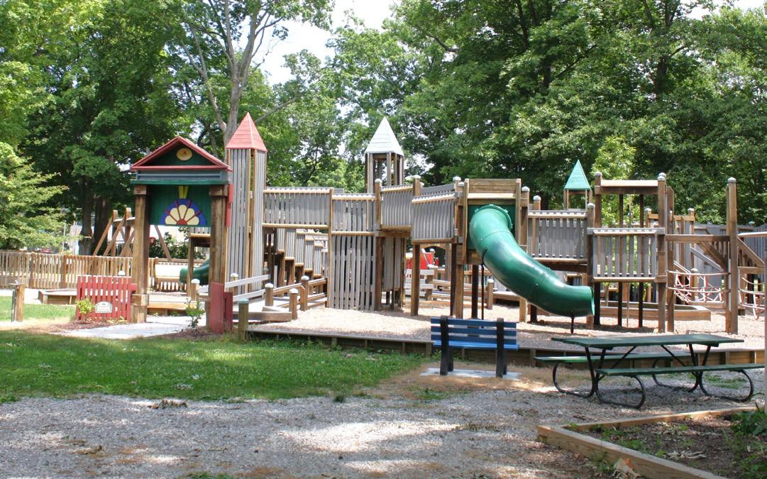
Murphy Park
Murphy Park is one of the central recreational spaces in New Harmony, Indiana, offering locals and visitors a peaceful, scenic retreat. Known for its welcoming, family-oriented atmosphere, Murphy Park serves as a hub for camping, shelters, outdoor activities, community events, and leisurely relaxation. Among its many features is Playtopia, a large and vibrant playground that has become a favorite spot for children and families alike.
Wabash River
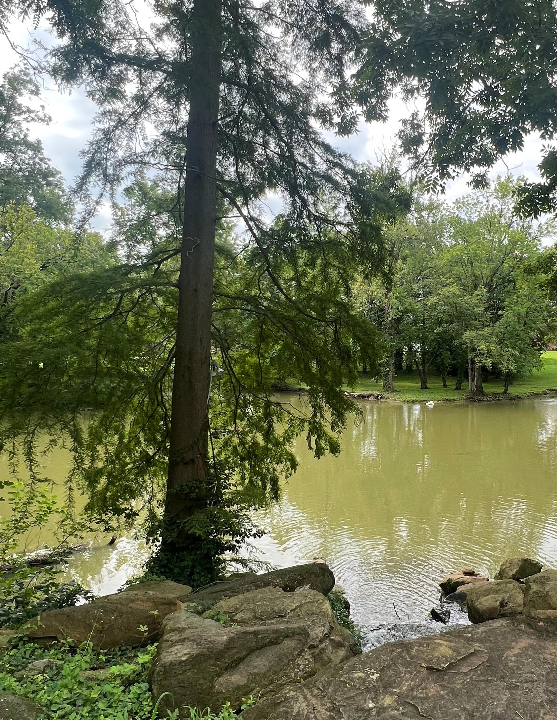
Historically, the Wabash River played a crucial role in New Harmony’s development, serving as a transportation route for goods and people. While river travel is less common today, the town maintains a strong connection to the Wabash River, with efforts to preserve its scenic views and waterfront areas.
Other Buildings and Sites
Several buildings from the original Harmonist settlement remain, offering a glimpse into the town’s early 19th-century past. The Lenz House is among the most well-preserved examples of Harmonist architecture. The building reflects the group’s values of simplicity, functionality, and communal living, and many are now part of guided tours and historical exhibitions. The Lenz House is leased by Historic New Harmony. Behind the Lenz House is the double log cabin, which was moved to New Harmony from a location near modern day SR 68 and SR 66.
Other log cabins on West Street were moved to New Harmony from Spencer Farm in White County and were placed on the original sites of Harmonist cabins.
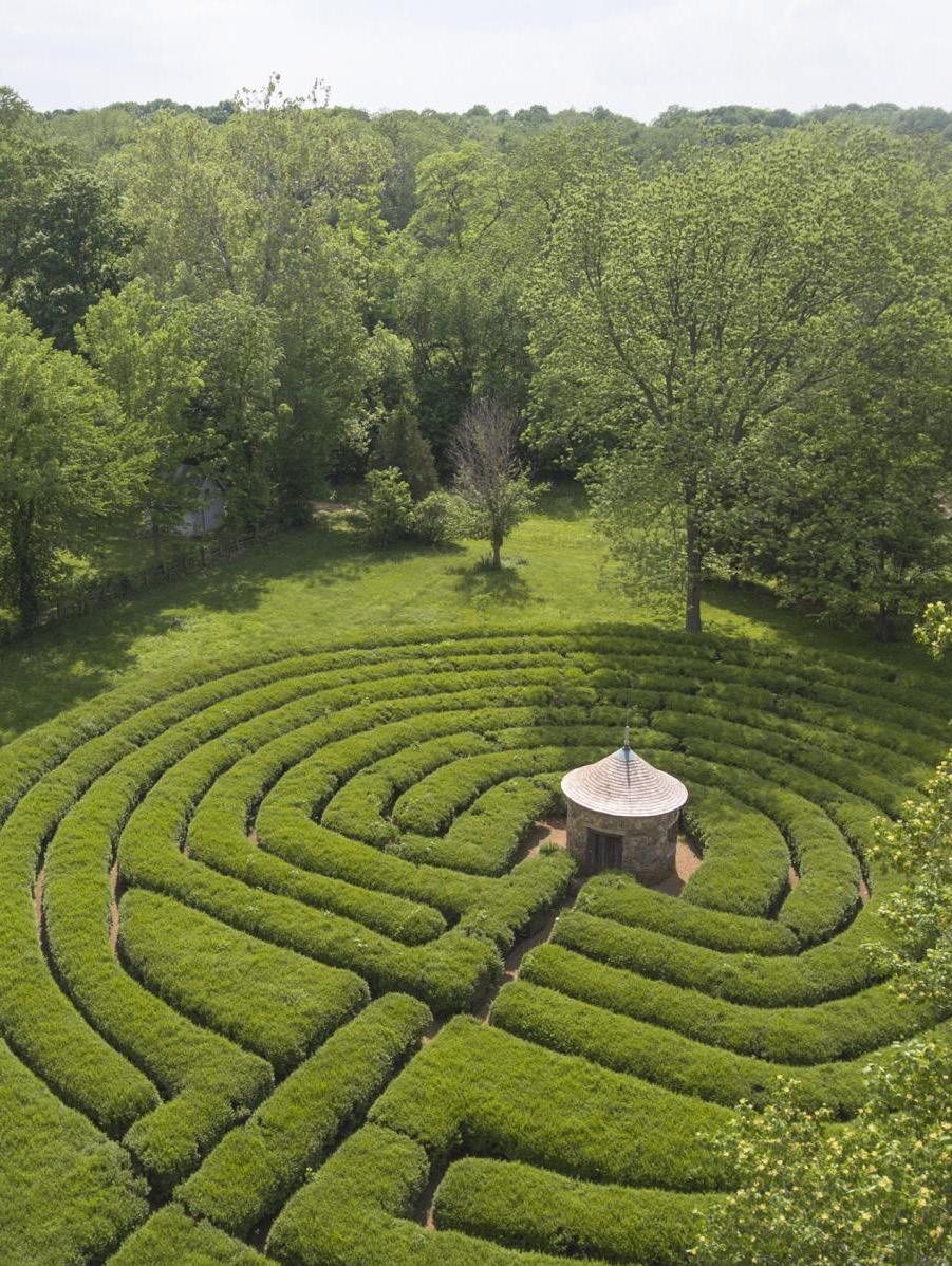
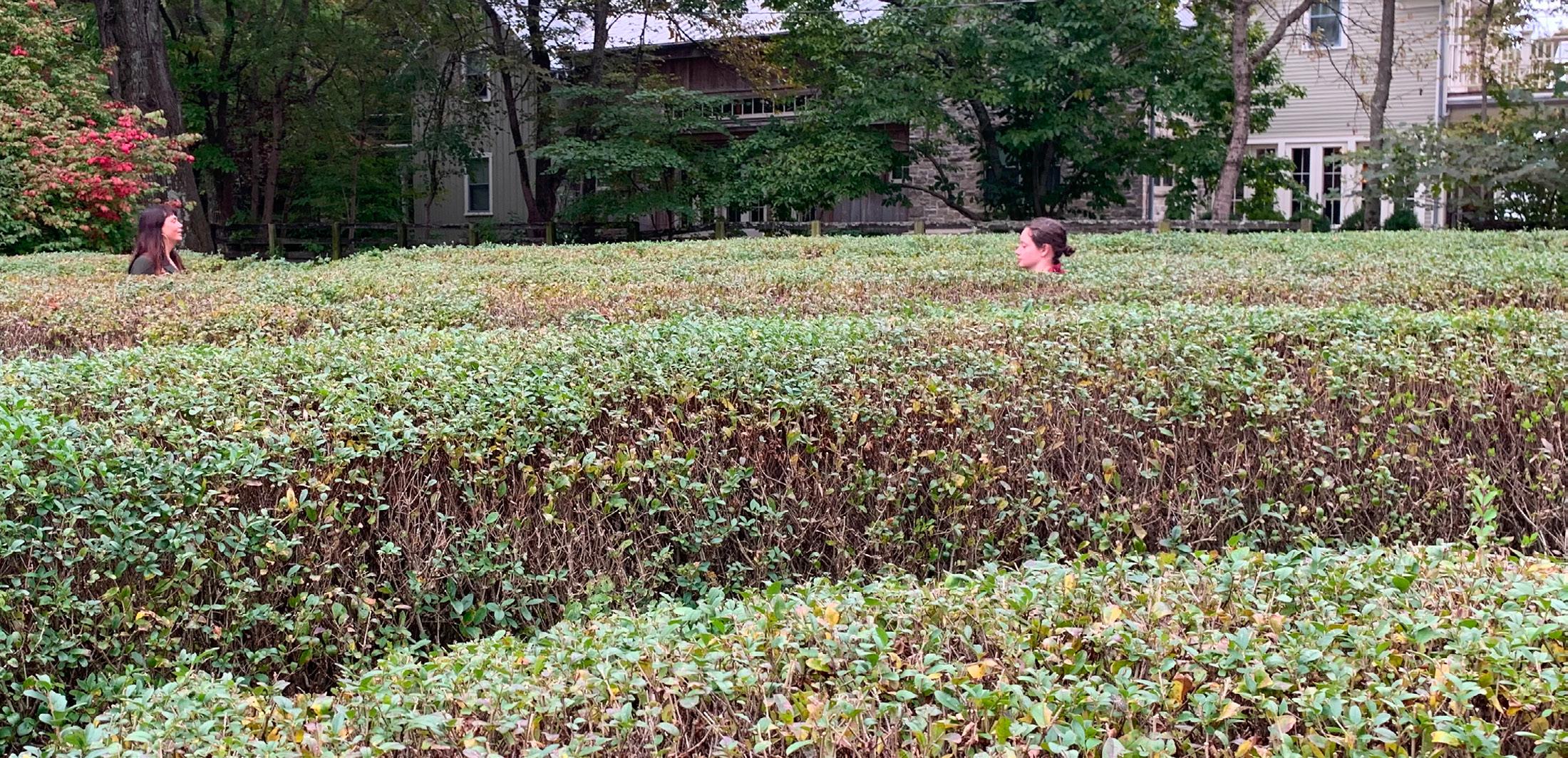
New Harmony features two labyrinths, each with its own historical and symbolic significance. The Harmonist Labyrinth, originally constructed by the Harmonists, was designed as a meditative space where visitors could reflect and find inner peace. A modern reconstruction of the labyrinth exists today. In 1997, a new labyrinth, the Cathedral Labyrinth, was built to offer a place for quiet contemplation, symbolizing the town’s ongoing connection to spiritual and intellectual exploration.
Goals and Policies
Goal: Celebrate the local natural, historic, and cultural assets and outdoor recreation activities for residents and visitors.
Policies
1. Activate the Wabash riverfront for fishing, canoeing, and kayaking.
2. Work with Posey County Visitors Bureau to continue to promote packages for New Harmony including further development of packages for recreation and cultural heritage tourism.
3. Encourage local businesses to continue golf cart rental and consider adding rental bikes.
ECONOMIC DEVELOPMENT
Economic Development broadly means the way a community brings revenue into the local economy and how it circulates through the community. Revenue that comes in from nonresidents adds new opportunity to the community in the form of jobs and wages, tax revenues, and word-of-mouth marketing when people have a good experience. Revenue leaks from the community when residents spend money outside of town, perhaps when commuting to another community to work or shop. Revenue that circulates within the community means residents supporting the livelihood of other residents.
Tourism
Tourism is the primary industry for New Harmony. Local shops that produce goods and services depend on outside visitors to generate sustainable income. Many of the businesses also serve residents. The challenge in tourism-based economies is always balancing the experiences for residents with those for visitors.
Places like the New Harmony Inn and Resort, bed and breakfast establishments (and short term rentals), antique shops, artists and art galleries, restaurants, and similar businesses are part of the tourism industry. Other places like the cultural assets depend on tourist visits to attract funding and donations.
Non-Tourism Business
Non-tourism businesses that are also not locally serving (like gas stations and grocery stores) include Hoehn Plastics Plant 3, which is headquartered in Poseyville, and the Wabash Valley Tree Service.
In line with the tourism economy, the largest employment sector in New Harmony is accommodations and food service. This sector includes all lodging places, restaurants, and bars.
The second largest employment sector in New Harmony is health care and social assistance. This sector includes nursing and residential care facilities like the Charles Ford Retirement Communities of New Harmony.
New Harmony residents leave the community to work in manufacturing, health care and social assistance, and accommodations and food service. Spending money in New Harmony supports local employment and continued operation of local businesses. When they shop outside the community while commuting to and from work, that spending is lost locally.
Goal and Policies
Goal: Retain and support development of local businesses that meet the needs of residents, provide jobs, and attract tourist spending to balance quality of life and the local tax base.
Policies:
1. Ensure home-based businesses, cottage industries, and small-scale manufacturing are permitted in appropriate zones through revision of the zoning ordinance.
2. Continue to market day, overnight, and weekend tourism packages to market segments like history enthusiasts, outdoor recreation adventure seekers, art and architecture admirers, wellness seekers, and educational explorers. Spend more of the available economic development revenue on tourism marketing.
3. Develop land and water-based recreation assets to attract tourist spending.
4. Market the community to work-fromanywhere professionals.
5. Leverage local and outside funds to improve tourism assets and quality of life amenities.
6. Repair and maintain sidewalks and trails to support walkability and tourism (See previous Transportation section)


The implementation chapter establishes the administrative elements of the postadoption process, outlines how the plan should be interpreted, establishes that the plan should be reviewed periodically, expresses how the plan should be used in decision-making, considers boundary adjustments and procedures for annexation that should be implemented, outlines considerations for the zoning and subdivision control ordinance update, and establishes priorities through an action plan implementation matrix.
ADMINISTRATION
Administration of the plan is a community-wide effort. The comprehensive plan is not a plan solely for the New Harmony Plan and Historic Preservation Commission to use, but for all town boards, commissions, and elected officials as well as nonprofit organizations, business owners, and property owners in the community.
Post adoption, there are steps to ensure that the plan is widely used and implemented:
Share the Plan Broadly
The plan document should be available where it will be used by the community, online and in person, but community leaders also need to continue to remind organizations and individuals that they should check the plan. This can take the form of briefings at community or organization meetings, reminders in community newsletters, and social media activities. It can also be coffee talks between leaders and members of the community.
Recruit Partners
Some of the partners are included in the implementation plan because the action step matches their purpose and mission. Town leaders will need to connect with organization leadership to ensure that the partners are aware of the plan, direction, and how they can play a critical role in implementation of the plan.
Secure Community Buy-In for the Plan
The plan had considerable engagement from the beginning of the process, but engaging people and sharing the plan ideas with them and adapting as needed is important to moving forward.
Empower Staff and Partners to Act
The leads and partners need to know that they move forward in implementing ideas in the plan. Communication is key to ensure that there isn’t duplication of efforts with limited resources or conflicting efforts, but this should not result in the plan stalling.
Schedule Recurring Updates
The plan needs to be reviewed annually for what has been accomplished. Those accomplishments should be communicated to the public, businesses, organizations, and partners. The annual review is also an opportunity to identify changes that may require a plan amendment or additional studies.
Under state law the comprehensive plan needs to be recorded with the Posey County Recorder’s office after adoption.
INTERPRETATION
A comprehensive plan is a policy document for the community. It is adopted by resolution of the New Harmony Plan and Historic Preservation Commission and the Town Council. It is used by the plan commission and town council in considering zoning changes, permits, or investments but it is also flexible to change as there are opportunities for the community. A comprehensive plan is different from the zoning and subdivision control ordinances, which are recommended by the New Harmony Plan and Historic Preservation Commission and adopted by ordinance of the New Harmony Town Council. These are the regulations for development in the community that require approvals, permits, and compliance.
PERIODIC REVIEW
Every five years there should be an update to the plan to address new realities with development, population changes, state and federal laws, and funding opportunities. A major change or disruptor in the community may trigger the need for an update outside the recommended pattern.
USING THE COMPREHENSIVE PLAN IN DECISION MAKING
When the plan commission has an opportunity to review a development proposal, any recommendation or decision should include how the proposal is in agreement with the comprehensive plan recommendations, guiding principles, and vision. This practice will facilitate consistency in decision making.
The comprehensive plan should, however, be interpreted broadly with the key consideration of how a proposal fits in the vision and aligns with the guiding principles more than any specific recommendation or action.
BOUNDARIES AND ANNEXATION
The corporate boundaries of the Town of New Harmony are documented inconsistently between the town and various county offices. The boundaries shown in the comprehensive plan include both the legally recorded boundaries with the Posey County Recorder’s Office and parcels that are included in the Town of New Harmony property tax district records maintained by the county. Reconciling these boundaries with the county offices will assist the town in legal matters moving forward.
When future annexations are made by the town, it is critical that state code regarding publication and recording be followed to ensure that the legal status of the property, the town boundary, and tax records are correct.
ZONING AND SUBDIVISION CONTROL ORDINANCE UPDATES
The town’s current zoning and subdivision control ordinances do not provide an adequate development regulatory framework for the town to ensure compatible development or development that aligns with expressed values. The ordinance should be updated, including processes and procedures for the plan commission and forms/processes for applicants.
Specific considerations include:
• Consider allowing accessory dwelling units
• Amend floodplain requirements in alignment with new state and federal guidance
• Remove requirements that are not applicable
• Amend uses to align with the comprehensive plan
• Resolve inconsistent provisions
• Amend district development standards to support the character desired by the town
• Consider adding provisions for missing middle housing types like duplexes or cottage court apartments
The State of Indiana does not provide grant funding for updates of zoning and subdivision control ordinances.
PRIORITIES
The priorities are presented as a matrix that includes the action, next step type, primary leads and partners, and an estimated timeframe. They are arranged by plan element after an overall/ administrative set of priorities.
The next steps are categorized as act now, prepare, or learn Some of the steps are things the town and partners can begin now. Others may require preparation such as funding, legal or engineering work, or additional information before they can begin. Some of the actions may require additional study or learning before a path forward can be determined. There are some actions that need to occur on a regular basis and those are identified as ongoing.
Potential funding is listed from known grants for which the town may be eligible and known town funding sources. Other funding may be identified by the town or partners as the plan is implemented.
Greater detail about the actions is included in each of the Chapter 4: Plan Elements sections. Definitions, acronyms, and agencies are described in the Appendices.
ADMINSTRATION
A0: File the comprehensive plan with the Posey County Recorder’s Office
A1: Correct recording of the town boundaries
A2: Establish procedures to ensure future annexations are properly published and recorded
A3: Develop an annexation strategy for annexing the town owned property straddling the river (Parcel ID 65-03-36-200003.000-006)
A4: Update the zoning and subdivision control ordinances
A5: Annual review of the comprehensive plan for accomplishments and changed circumstances
A6: 5 year review of comprehensive plan for needed amendments
A7: Implement the recommendations of the Baker Tilly financial study
A8: Support continuing education for the Clerk-Treasurer and Town Council as well as town staff
LAND USE
LU1: Draft, adopt, and enact a Heritage Area Preservation Overlay District including boundaries and regulations
HOUSING
H1: Study and consider accessory dwelling units and missing middle housing types for inclusion in the zoning ordinance
Step
TRANSPORTATION
T1: Work with INDOT to design and install crosswalks at Church and East Streets and Main and Tavern Streets Act Now
T2: Fund and develop a costshare program for sidewalk repair
T3: Ensure minimum ADA compatibility for sidewalks and crossings
T4: Consider adopting PROWAG as the town’s accessibility standard
T5: Plan for repaving local roads and streets
INDOT
T6: Develop a trail to Harmonie State Park Prepare Town of New Harmony, Posey County, Indiana DNR
T7: Open the Harmony Way Bridge Learn
UTILITIES
U1: Continue to implement the town’s “Lead and Copper Rule Improvements” in accordance with the EPA baselines and deadlines.
U2: Implement a study for expansion and upgrades to the town’s sewage treatment plant.
U3: Implement a study of the town’s storm water system and consider funding sources for its maintenance and upgrades
U4: Develop an infrastructure plan for the town.
ECONOMIC DEVELOPMENT
ED1: Increase marketing spending with One New Harmony Act Now
ED2: Fund a grant writer/ coordinator with One New Harmony to leverage local funds with state, federal, and philanthropic grants to support programs and facilities
ED3: Study the potential for creating an Economic Development Commission or Redevelopment Commission for use of economic incentives like tax abatement and tax increment finance (TIF)
ED4: Construct and maintain downtown restrooms Act Now
ED5: Seek volunteers interested in renewing the farmer’s market to feature local and Midwest products derived from locally sourced ingredients and materials
RECREATION AND CULTURAL ASSETS
RC1: Install a fishing pier at the Wabash River Act Now
RC2: Install a kayak launch at the Wabash River Act Now
RC3: Install a shared lifejacket station at the Wabash River
RC4: Established the town owned property on the west bank of the Wabash as a picnic site
RC5: Maintain and upgrade parks facilities and equipment as recommended in the 5-Year Parks and Recreation Master Plan
RC6: Install historical and interpretative signs as recommended in the 5-Year Parks and Recreation Master Plan
economic development fund
economic development fund

APPENDIX A: DEFINITIONS AND RESOURCES
DEFINITIONS
Accessory Dwelling Units
An Accessory Dwelling Unit (ADU), also known as a granny flat or an in-law suite, is a secondary residential unit on a property that is typically attached to or near the main single-family residence. These units provide independent living space with a full kitchen and bathroom, often used for family members, renters, or as a source of income.
Legislation in Indiana allows for the creation of ADUs, specifying that their size range from a minimum of 220 square feet to a maximum of 800 square feet. An ADU must also be smaller than the main residence, typically not exceeding 50% of the primary dwelling’s living space.
ADA (Americans with Disabilities Act)
Accessibility standards issued under the Americans with Disabilities Act (ADA) apply to places of public accommodation, commercial facilities, and state and local government facilities in new construction, alterations, and additions. The ADA Standards are based on minimum guidelines set by the Access Board.
The Department of Justice (DOJ) and the Department of Transportation (DOT) issue the ADA Standards. DOJ’s ADA Standards apply to all facilities except public transportation facilities, which are subject to DOT’s ADA Standards. This version of the ADA Standards combines both documents and notes unique provisions in the DOJ Standards and the DOT Standards.
Agricultural Business (Small
Scale)
Small-scale agricultural businesses can be profitable and sustainable by focusing on high-value crops, utilizing efficient farming methods, and diversifying income streams. Examples include microgreens farming, beekeeping, mushroom cultivation, organic farming, event barns/venues, and agritourism.
Community Crossings
Community Crossings Matching Grant Program provides funding to cities, towns, and counties across Indiana to make improvements to local roads and bridges.
Community Crossings is a partnership between INDOT and Hoosier communities, both urban and rural, to invest in infrastructure projects that catalyze economic development, create jobs, and strengthen local transportation networks.
INDOT holds two CCMG Call for Projects each year, one in January and one in July. Projects that are eligible for funding through Community Crossings include road and bridge preservation projects with Americans with Disabilities Act (ADA) compliance in connection with these projects. Material costs for chip sealing and crack filling operations are also eligible for funding. CCMG awards state funds for CONSTRUCTION ONLY; maintenance of traffic is part of construction and DOES NOT participate in contingency fees on contractor contracts.
Cottage Court Housing
A group of small (1 to 1.5-story), detached structures arranged around a shared court visible from the street. The shared court is an important community-enhancing element and unit entrances should be from the shared court. It replaces the function of a rear yard.
Cottage Industries
A cottage industry business is a small manufacturing business typically operated from the home or a small workshop, usually by family members or a close-knit community. The term “cottage industry” refers to when skilled craftsmen and artisans crafted goods within their cottages, utilizing their own equipment and resources.
Cottage industries are often small-scale, family-run small businesses that have a rich history dating back centuries and continue to play a significant role in various economies worldwide.
Examples of cottage industries include traditional trades, agricultural pursuits, or older industries. Some cottage industries include maple syrup and honey production, pottery, microbreweries, distilleries, and woodworking.
Economic Development Commission
Economic Development Commissions can be established by local units of government. They operate under the same general circumstances as redevelopment commissions, but they are engaged in the work of economic development areas (not meeting the findings of an area in need of redevelopment). Their primary purpose is to attract or retain jobs, increase the property tax base, improve the diversity of the economic base, or provide similar economic benefits to the community.
Farm to Table
Farm-to-table is a movement promoting locally sourced food, aiming to connect consumers directly with the producers of their food. This can involve restaurants sourcing ingredients directly from farms, farmers’ markets, or even having their own gardens. The goal is to support local economies, reduce food miles, and provide fresher, potentially more nutritious food.
More information is available at https://www.access-board. gov/ada/#department-of-transportation-ada-standards-fortransportation-facilities-2006
Indiana DNR
The Indiana Department of Natural Resources
The Indiana Department of Transportation
National Register of Historic
Places
The National Register of Historic Places is the official list of the nation’s historic places worthy of preservation. Authorized by the National Historic Preservation Act of 1966, the National Park Service’s National Register of Historic Places is part of a national program to coordinate and support public and private efforts to identify, evaluate, and protect America’s historic and archeological resources.
Listing in the National Register is the first step towards eligibility for National Park Service-administered federal preservation tax credits that have leveraged more than $45 billion in private investment and National Park Service grant programs like Save America’s Treasures and Preserve America.
Next Level Trails
Next Level Trails has invested $180 million – the largest infusion of State trail funding in Indiana history – toward the development of regionally and locally significant trails throughout Indiana. As part of former Governor Holcomb’s broader Next Level Connections infrastructure program, Next Level Trails (NLT) is designed to incentivize collaborative efforts to accelerate trail connections. There is currently no Next Level Trails Funding, a fifth round would depend on future funding. The Next Level Connections transportation initiative was focused on improving the state’s transportation infrastructure through investment in roads, bridges, and other related projects. The is also a Next Level Connections Broadband Program. Until the new administration programs and budget is established the future of these programs is unknown.
PROWAG (Public Right of Way Accessibility Guidelines
The Access Board has published new guidelines under the Americans with Disabilities Act (ADA) and the Architectural Barriers Act (ABA) that address access to sidewalks and streets, crosswalks, curb ramps, pedestrian signals, on-street parking, and other components of public right-of-way. These guidelines also review shared use paths, which are designed primarily for use by bicyclists and pedestrians for transportation and recreation purposes. The Access Board is an independent federal agency that advances accessibility through leadership in accessible design and the development of accessibility guidelines and standards. These guidelines contain scoping and technical requirements to ensure that pedestrian facilities located in the public right-of-way (including a public right-of-way that forms the boundary of a site or that lies within a site bounded by a property line), are readily accessible to and usable by pedestrians with disabilities. These guidelines do not address existing pedestrian facilities unless the pedestrian facilities are altered at the discretion of a covered entity. All newly constructed pedestrian facilities and altered portions of existing pedestrian facilities for pedestrian circulation and use located in the public right-of-way shall comply with these guidelines.More information is available at https://www.accessboard.gov/prowag/
Redevelopment Commission
In Indiana, a Redevelopment Commission (RDC) is a local government entity established to promote economic development and address blight in specific areas. These commissions are authorized under Indiana Code 36-7-14 and can be created by counties, cities, or towns. Their primary tools include Tax Increment Financing (TIF) and other redevelopment strategies to encourage private investment and revitalize areas needing improvement. Redevelopment Commissions typically engage in the work related to areas of redevelopment.
Tax abatement (Real Property)
A property tax deduction from the assessed valuation granted by the designating body for the construction of a new structure or a rehabilitation of property in an ERA. (It does not include land.) Eligible property includes construction of new structures, additions to existing structures, or the remodeling, repairs, or betterments of property if it increases the assessed value.
Tax Increment Finance
Tax Increment Finance (TIF) provides for the temporary allocation to redevelopment districts of increased tax proceeds (known as “increment”) in an allocation area generated by increases in assessed value. Thus, TIF permits units to use increased tax revenues stimulated by redevelopment to pay for the capital improvements needed to induce the redevelopment.
US DOJ
The United States Department of Justice
The United States Department of Transportation
RESOURCES
Indiana Comprehensive Plan
Enabling
Statute
The enabling legislation for comprehensive planning is found in Indiana Code 36-7-4 in the 500 series.
Indiana Code 36-7-4 500 Series
IC 36-7-4-500 Series Comprehensive plan
Sec. 500. This series (sections 500 through 599 of this chapter) may be cited as follows: 500 SERIES COMPREHENSIVE PLAN.
[Local Government Recodification Citation: New.]
As added by Acts 1981, P.L.309, SEC.23.
IC 36-7-4-501 Comprehensive plan; requirement; approval; purpose
Sec. 501. A comprehensive plan shall be approved by resolution in accordance with the 500 series for the promotion of public health, safety, morals, convenience, order, or the general welfare and for the sake of efficiency and economy in the process of development. The plan commission shall prepare the comprehensive plan.
[Pre-Local Government Recodification Citations: 18-7-2-31; 18-74-501; 18-7-4-36; 18-7-5-32.]
As added by Acts 1981, P.L.309, SEC.23. Amended by Acts 1981, P.L.310, SEC.26; P.L.335-1985, SEC.3.
IC 36-7-4-502 Comprehensive plan; contents
Sec. 502. A comprehensive plan must contain at least the following elements:
(1) A statement of objectives for the future development of the jurisdiction.
(2) A statement of policy for the land use development of the jurisdiction.
(3) A statement of policy for the development of public ways, public places, public lands, public structures, and public utilities.
[Pre-Local Government Recodification Citations: 18-7-4-502; 18-7-4-33.]
As added by Acts 1981, P.L.309, SEC.23. Amended by Acts 1981, P.L.310, SEC.27; P.L.335-1985, SEC.4.
IC 36-7-4-503 Comprehensive plan; additional contents
Sec. 503. A comprehensive plan may, in addition to the elements required by section 502 of this chapter, include the following:
(1) Surveys and studies of current conditions and probable future growth within the jurisdiction and adjoining jurisdictions.
(2) Maps, plats, charts, and descriptive material presenting basic information, locations, extent, and character of any of the following:
(A) History, population, and physical site conditions.
(B) Land use, including the height, area, bulk, location, and use of private and public structures and premises.
(C) Population densities.
(D) Community centers and neighborhood units.
(E) Areas needing redevelopment and conservation.
(F) Public ways, including bridges, viaducts, subways, parkways, and other public places.
(G) Sewers, sanitation, and drainage, including handling, treatment, and disposal of excess drainage waters, sewage, garbage, refuse, and other wastes.
(H) Air, land, and water pollution.
(I) Flood control and irrigation.
(J) Public and private utilities, such as water, light, heat, communication, and other services.
(K) Transportation, including rail, bus, truck, air and water transport, and their terminal facilities.
(L) Local mass transit, including taxicabs, buses, and street, elevated, or underground railways.
(M) Parks and recreation, including parks, playgrounds, reservations, forests, wildlife refuges, and other public places of a recreational nature.
(N) Public buildings and institutions, including governmental administration and service buildings, hospitals, infirmaries, clinics, penal and correctional institutions, and other civic and social service buildings.
(O) Education, including location and extent of schools and postsecondary educational institutions.
(P) Land utilization, including agriculture, forests, and other uses.
(Q) Conservation of energy, water, soil, and agricultural and mineral resources.
(R) Any other factors that are a part of the physical, economic, or social situation within the jurisdiction.
(3) Reports, maps, charts, and recommendations setting forth plans and policies for the development, redevelopment, improvement, extension, and revision of the subjects and physical situations (set out in subdivision (2) of this section) of the jurisdiction so as to substantially accomplish the purposes of this chapter.
(4) A short and long range development program of public works projects for the purpose of stabilizing industry and employment and for the purpose of eliminating unplanned, unsightly, untimely, and extravagant projects.
(5) A short and long range capital improvements program of governmental expenditures so that the development policies established in the comprehensive plan can be carried out and kept up-to-date for all separate taxing districts within the jurisdiction to assure efficient and economic use of public funds.
(6) A short and long range plan for the location, general design, and assignment of priority for construction of thoroughfares in the jurisdiction for the purpose of providing a system of major public ways that allows effective vehicular movement, encourages effective use of land, and makes economic use of public funds.
[Pre-Local Government Recodification Citations: 18-7-4-503; 18-7-4-37; 18-7-5-37.]
As added by Acts 1981, P.L.309, SEC.23. Amended by Acts 1981, P.L.310, SEC.28; P.L.335-1985, SEC.5; P.L.220-1986, SEC.9; P.L.185-2005, SEC.6; P.L.2-2007, SEC.386.
IC 36-7-4-504 Comprehensive plan; consideration of policy and pattern; validation, continuance, and consolidation of preexisting plans
Sec. 504. (a) After the comprehensive plan is approved for a jurisdiction, each governmental entity within the territorial jurisdiction where the plan is in effect shall give consideration to the general policy and pattern of development set out in the comprehensive plan in the:
(1) authorization, acceptance, or construction of water mains, sewers, connections, facilities, or utilities;
(2) authorization, construction, alteration, or abandonment of public ways, public places, public lands, public structures, or public utilities; and
(3) adoption, amendment, or repeal of zoning ordinances, including zone maps and PUD district ordinances (as defined in section 1503 of this chapter), subdivision control ordinances, historic preservation ordinances, and other land use ordinances.
(b) A comprehensive plan or master plan adopted or approved under any prior law is validated and continues in effect as the comprehensive plan for the plan commission in existence on September 1, 1986, or any successor plan commission until the plan becomes a part of or is amended or superseded by the comprehensive plan of the latter plan commission. In addition, a thoroughfare plan adopted or approved under any prior law is validated and continues in effect as a part of the comprehensive plan on and after September 1, 1986, until the thoroughfare plan is amended or superseded by changes in the comprehensive plan approved under this chapter.
(c) AREA. To effect the consolidation of the various plans and ordinances in force in the county and in the participating municipality into one (1) comprehensive plan, the area plan commission shall approve the comprehensive plans of the participating municipalities as its first comprehensive plan. The commission shall also recommend under applicable law to the participating legislative bodies, without amendment, the adoption of the zoning, subdivision control, thoroughfare, and other ordinances relating to the jurisdiction of the participating legislative body. If lands within the jurisdiction of the commission are not regulated by zoning ordinances, the commission shall classify those lands as residential or agricultural, until they can conduct such land use studies as are necessary for reclassification and zoning. Because the unification of the planning and zoning function is of an emergency character, the commission and
the participating legislative bodies shall initially adopt these preliminary plans and ordinances by simple resolution, to continue in effect until finally adopted in conformity with the area planning law.
[Pre-Local Government Recodification Citations: 18-7-3-12; 187-4-504; 18-7-4-45; 18-7-4-94 part; 18-7-5-45.]
As added by Acts 1981, P.L.309, SEC.23. Amended by P.L.3351985, SEC.6; P.L.220-1986, SEC.10; P.L.320-1995, SEC.5.
IC 36-7-4-504.5 Comprehensive plan; township advisory committee
Sec. 504.5. (a) In preparing or revising a comprehensive plan for a township, the legislative body of the consolidated city shall adopt an ordinance requiring the plan commission to establish an advisory committee of citizens interested in problems of planning and zoning for that township, a majority of whom shall be nominated by the township legislative body.
(b) An advisory committee created under subsection (a) must include a representative of the affected township legislative body as determined by procedures established in an ordinance adopted by the legislative body of the consolidated city.
As added by P.L.164-1995, SEC.18.
IC 36-7-4-505 Comprehensive plan; requests for related information
Sec. 505. (a) When the plan commission undertakes the preparation of a comprehensive plan, the commission may request any public or private officials to make available any information, documents, and plans that have been prepared and that provide any information that relates to the comprehensive plan.
(b) All officials and departments of state government and of the political subdivisions operating within lands under the jurisdiction of the plan commission shall comply with requests under subsection (a).
(c) All officials of public and private utilities operating within lands under the jurisdiction of the plan commission shall comply with requests under subsection (a) to furnish public information.
[Pre-Local Government Recodification Citations: 18-7-2-32 part; 18-7-4-505; 18-7-4-40.]
As added by Acts 1981, P.L.309, SEC.23. Amended by Acts 1981, P.L.310, SEC.29; P.L.335-1985, SEC.7.
IC 36-7-4-506 Thoroughfare plans included in comprehensive plans; location, change, vacation, or improvement of thoroughfares
Sec. 506. (a) A thoroughfare plan that is included in the comprehensive plan may determine lines for new, extended, widened, or narrowed public ways in any part of the territory in the jurisdiction.
(b) The determination of lines for public ways, as provided in subsection (a), does not constitute the opening, establishment, or acceptance of land for public way purposes.
(c) After a thoroughfare plan has been included in the comprehensive plan, thoroughfares may be located, changed, widened, straightened, or vacated only in the manner indicated by the comprehensive plan.
(d) After a thoroughfare plan has been included in the comprehensive plan, the plan commission may recommend to the agency responsible for constructing thoroughfares in the jurisdiction the order in which thoroughfare improvements should be made.
[Pre-Local Government Recodification Citations: 18-7-2-32 part; 18-7-4-506; 18-7-4-38; 18-7-5-38.]
As added by Acts 1981, P.L.309, SEC.23. Amended by Acts 1981, P.L.310, SEC.30; P.L.335-1985, SEC.8; P.L.220-1986, SEC.11.
IC 36-7-4-507 Comprehensive plan; notice and hearings before adoption
Sec. 507. Before the approval of a comprehensive plan, the plan commission must:
(1) give notice and hold one (1) or more public hearings on the plan;
(2) publish, in accordance with IC 5-3-1, a schedule stating the times and places of the hearing or hearings. The schedule must state the time and place of each hearing, and state where the entire plan is on file and may be examined in its entirety for at least ten (10) days before the hearing.
[Pre-Local Government Recodification Citations: 18-7-2-33; 187-4-507; 18-7-4-41; 18-7-5-39.]
As added by Acts 1981, P.L.309, SEC.23. Amended by Acts 1981, P.L.45, SEC.18; P.L.335-1985, SEC.9.
IC 36-7-4-508 Comprehensive plan; adoption; certification; plan and summary availability for inspection; legalization of certain comprehensive plans
Sec. 508. (a) After a public hearing or hearings have been held, the plan commission may approve the comprehensive plan.
(b) ADVISORY AREA. Upon approval, the plan commission shall certify the comprehensive plan to each participating legislative body.
(c) The plan commission may approve each segment of the comprehensive plan as it is completed. However, that approval does not preclude future examination and amendment of the comprehensive plan under the 500 series. A comprehensive plan that:
(1) was approved before March 14, 1994, under this subsection as in effect before March 14, 1994; and
(2) was not filed in the county recorder’s office as required by this subsection as in effect before March 14, 1994; is legalized.
(d) METRO. As used in this subsection, “comprehensive plan” or “plan” includes any segment of a comprehensive plan. Approval of the comprehensive plan by the metropolitan development commission is final. However, the commission may certify the comprehensive plan to the legislative body of each municipality in the county, to the executive of the consolidated city, and to any other governmental entity that the commission wishes. The commission shall make a complete copy of the plan available for inspection in the office of the plan commission. One (1) summary of the plan shall be recorded in the county recorder’s office. The summary of the plan must identify the following:
(1) The major components of the plan.
(2) The geographic area subject to the plan, including the townships or parts of townships that are subject to the plan.
(3) The date the commission adopted the plan.
[Pre-Local Government Recodification Citations: 18-7-2-34; 187-4-508; 18-7-4-42 part; 18-7-5-40; 18-7-5-41.]
As added by Acts 1981, P.L.309, SEC.23. Amended by P.L.3351985, SEC.10; P.L.31-1994, SEC.11; P.L.220-2011, SEC.661.
IC 36-7-4-509 Comprehensive plan; legislative approval, rejection, or amendment
Sec. 509. (a) ADVISORY AREA. After certification of the comprehensive plan, the legislative body may adopt a resolution approving, rejecting, or amending the plan. Such a resolution requires only a majority vote of the legislative body, and is not subject to approval or veto by the executive of the adopting unit, and the executive is not required to sign it.
(b) ADVISORY AREA. The comprehensive plan is not effective for a jurisdiction until it has been approved by a resolution of its legislative body. After approval by resolution of the legislative body of the unit, it is official for each unit that approves it. Upon approval of the comprehensive plan by the legislative body, the clerk of the legislative body shall place one (1) copy of the comprehensive plan on file in the office of the county recorder.
[Pre-Local Government Recodification Citations: 18-7-2-35 part; 18-7-4-509; 18-7-4-42 part; 18-7-4-43 part; 18-7-5-42.]
As added by Acts 1981, P.L.309, SEC.23. Amended by P.L.3351985, SEC.11; P.L.220-1986, SEC.12.
IC 36-7-4-510 Comprehensive plan; procedure following legislative rejection or amendment
Sec. 510. (a) ADVISORY AREA. If the legislative body, by resolution, rejects or amends the comprehensive plan, then it shall return the comprehensive plan to the plan commission for its consideration, with a written statement of the reasons for its rejection or amendment.
(b) ADVISORY AREA. The commission has sixty (60) days in which to consider the rejection or amendment and to file its report with the legislative body. However, the legislative body may grant the commission an extension of time, of specified duration, in which to file its report. If the commission approves the amendment, the comprehensive plan stands, as amended by the legislative body, as of the date of the filing of the commission’s report with the legislative body. If the commission disapproves the rejection or amendment, the action of the legislative body on the original rejection or amendment stands only if confirmed by another resolution of the legislative body.
(c) ADVISORY AREA. If the commission does not file a report with the legislative body within the time allotted under subsection (b), the action of the legislative body in rejecting or amending the comprehensive plan becomes final.
[Pre-Local Government Recodification Citations: 18-7-4-510; 18-7-5-43.]
As added by Acts 1981, P.L.309, SEC.23. Amended by Acts 1981, P.L.310, SEC.31; P.L.335-1985, SEC.12; P.L.220-1986, SEC.13.
IC 36-7-4-511 Comprehensive plan; amendment approval; preparation and submission of amendments
Sec. 511. (a) Each amendment to the comprehensive plan must be approved according to the procedure set forth in the 500 series.
(b) ADVISORY AREA. If the legislative body wants an amendment, it may direct the plan commission to prepare the amendment and submit it in the same manner as any other amendment to the comprehensive plan. The commission shall prepare and submit the amendment within sixty (60) days after the formal written request by the legislative body. However, the legislative body may grant the commission an extension of time, of specified duration, in which to prepare and submit the amendment.
[Pre-Local Government Recodification Citations: 18-7-2-35 part; 18-7-4-511; 18-7-4-43 part; 18-7-5-44.]
As added by Acts 1981, P.L.309, SEC.23. Amended by P.L.3351985, SEC.13; P.L.220-1986, SEC.14.
IC 36-7-4-512 Comprehensive plan; capital improvement projects
Sec. 512. METRO. This section applies only to capital improvement projects consisting of real or personal property (or improvements) that have a useful life of more than one (1) year and a value of more than one hundred thousand dollars ($100,000). At least thirty (30) days before a governmental entity within the county:
(1) undertakes or acquires any such capital improvement project;
(2) starts the required proceedings to spend money or let contracts for such a project; or
(3) authorizes the issuance of bonds for the purpose of financing such a project; the governmental entity must notify the metropolitan development commission in writing of the location, cost, and nature of the project. The commission may by rule limit the kinds of capital improvement projects that are subject to the notification requirement of this section. The commission may designate an agency responsible for fiscal analyses or control to receive notifications required by this section.
[Pre-Local Government Recodification Citations: 18-7-2-36; 187-3-13 part; 18-7-4-512; 18-7-4-44; 18-7-5-46.]
As added by Acts 1981, P.L.309, SEC.23. Amended by Acts 1981, P.L.310, SEC.32; P.L.335-1985, SEC.14.
PLANNING PROCESS
The consultant, Rundell Ernstberger Associates (REA) used the following four-stage approach to develop the comprehensive plan:
1. Discovery: Community Needs Assessment & Analysis
2. Visioning: Input Meetings & Vision Setting
3. Framework: Plan Elements
4. Action: Implementation, Draft Plan
Phase 1: Discovery
In the discovery phase, REA kicked off the project with the town’s project manager, reviewed existing demographics and physical conditions data, analyzed that data collected by the town, and began to organize opportunities and issues to be addressed in the plan. The outcome of this phase was to identify the strengths, weaknesses, issues, and opportunities that will be built upon or addressed in the plan based on the current conditions and needs. REA also identified key trends that need to continue, change, or be developed. The information from this phase helped to inform the vision for the future as well as recommendations in plan development.
The project kicked off with a meeting and tour of the town to discuss opportunities/challenges, initial impressions, and potential outcomes for the comprehensive plan.
REA created a demographic profile of the community including number of people, households, households by age, income, race and ethnicity, educational attainment, etc. The purpose of this information is to understand what the trends are and how they have changed. REA also reviewed relevant plans and documents provided by the town, reviewed demographic and economic data, and assessed the town’s plans to understand goals and policies for areas such as land use, transportation, infrastructure, quality of life, and environmental/natural resource conditions.
A Steering Committee helped develop a list of key stakeholders and participated in opportunity and issue identification exercises for the comprehensive plan. The Steering Committee also discussed a vision for the future, values, and goals to be included in the plan.
Phase 2: Visioning
Building upon the results of the discovery phase, the visioning phase focused on the 20-year vision of the comprehensive plan. This included developing a vision statement and identifying key community values as well as the goals and objectives for each plan element. Visioning set the policy basis for the recommendations in the plan. Based on the vision, land use and transportation concepts were prepared and reviewed by the Steering Committee and public for comment.
Community Planning Week was a 4-day workshop where the consultant team hosted a series of workshops with a variety of stakeholders including plan commission, town council, stakeholder groups, and the public. The consultant team was available throughout the week, in an open office-style setting, to engage with stakeholders and host informal meetings to showcase project progress and collaborate as a team on plan development. The first evening of Community Planning Week involved a community workshop for input to the planning process. At the conclusion of Community Planning Week, REA reported back to stakeholders and the public on general findings, project direction, and next steps.
Phase 3: Framework
During the framework phase REA used the technical analysis from the discovery phase combined with community input and results of the visioning phase to create the plan elements and policy recommendations. The outcome was the future land use map, policies, and recommendations that will guide staff, elected and appointed officials in their decision making.
REA developed a future land use plan that includes pattern and character of growth; location and intensity of various development types; protection and preservation of natural resources and historic features; and needed amendments to public policy (zoning and subdivision control).
REA identified transportation elements in alignment with the land use plan. This includes improvements to key intersections and new roadways to serve additional development. The utilities component focused on recommendations for water, sanitary sewer, and stormwater systems.
The economic development plan included review of existing regional plans and coordination with economic development players in the area to tailor a strategy that best fits the goals of the town.
Recreation and cultural assets was another element of the plan. While the 5-Year Parks and Recreation Master Plan was developed concurrently with the comprehensive plan, there are important aspects of the town’s cultural assets related to tourism that are important to the tourism economy and local quality of life.
REA developed a set of project priorities that are in harmony with the overall goals of the comprehensive plan and address anticipated needs.
Phase 4: Action
During the action phase, the implementation strategies were created and the draft comprehensive plan was prepared — containing the project process, outcomes, vision, plan elements and recommendations, and implementation plan. The plan was presented at a community open house and a public hearing for the community review.
An implementation strategy provides guidance for the town to make decisions and implement plan recommendations.

PUBLIC ENGAGEMENT
The public engagement process for the New Harmony Comprehensive Plan ran parallel to the 5-Year Parks and Recreation Master Plan. The comprehensive plan engagement activities included surveys, a community event, community planning week, a project webpage, and a community open house.
Surveys
Two types of surveys were conducted during the comprehensive plan process. The first was a survey to solicit information from those who live or work in New Harmony about their experiences with the community and a separate survey for visitors. The other type of survey was the participant demographic survey that was used to further engage with people who participated in the public events (in person or online) and be able to identify how the people participating represented the town’s demographics.
Resident and Employee Survey
Visitor surveys were conducted during early October 2024 and available both online and in hard copy. 12 surveys were filled out. Participants were:
• Retired (10)
• Lived in New Harmony (9) or in Posey County outside New Harmony (2)
• Lived in New Harmony for more than 11 years or all their life (8)
• Were over age 55 (12), some over 75 (5)
• Male (7)
• Did not have children under 18 living at home (11)
• Own their home and it is their primary residence (7)
• White (11)
• Had incomes under $75,000 (10)
In response to the question about change they would like to see in New Harmony the responses were:
• Opening the bridge (2)
• Resurfacing Church Street
• Stop cutting down trees
• A more cohesive sense of community
• A small grocery store
• Daily lunch service (restaurant)
• More services for older residents
Total Surveys Completed:
163
Resident and Employee Surveys:
12
Visitor Surveys:
26
Demographic Surveys:
125
Concerns about the future included:
• Increased cost of living (4)
• Housing affordability (6)
• Environmental issues (4)
• Maintaining legacy and rising to the challenge
• Availability of health care services (5)
• Low wages from jobs in New Harmony
• Public safety
• Aging or missing infrastructure
• Access to regional destinations (4) Participants rated the following services out of 5 stars:
• Safety – 4
• Water and Sewer Service – 3
• Broadband – 2.8
• Parks, Trails, and Recreational Facilitie – 3.9
• Healthcare Facilities – 2.9
1.
2.
7.
?
9.
4.
6.
Visitor Survey
Visitor surveys were conducted during early October 2024 and available both online and in hard copy. There were 26 surveys completed. Twenty-five of the participants indicated that they would recommend New Harmony as a travel destination to friends or family. Stays ranged from part of a day (common) to 3-5 days (5 participants). Most participants visit New Harmony less than once a year.
Several satisfaction questions were asked with participants responding on a scale from one to five, with five being the highest score. The average score for each topic was:
• Cleanliness – 4.7
• Quality of Attraction – 4.3
• Accessibility – 4.5
• Availability of Information/Tourist Guides – 4.4
• Friendliness/Hospitality of Locals – 4.7
• Safety and Security – 4.6
• Generosity – 4
• Social Support Services – 3.3
• Trust in Local Government – 3.5
Comments included that the town needs wifi on a communitywide basis because of the limited cellular service and that longer weekend hours for dining would be appreciated.
5. What activities have you participated in during your visit to New Harmony ? Select all that apply.
a. Sightseeing / Tours
b. Dining
c. Shopping
d. Outdoor recreation (e.g., hiking, biking)
e. Cultural / Historical Sites
f. Attending Social Events (e.g., festivals, fairs, concerts)
g. Other (please specify)
6. What do you like most about New Harmony ? Select up to 3 choices
a. Natural Scenery
b. Historic Sites
c. Local Culture / Community
d. Dining Options
e. Shopping Opportunities
f. Outdoor Activities
g. Festivals / Events
h. Other (please specify)
7. What improvements would enhance your experience in New Harmony ? Select up to 3 choices
a. More attractions
b. Improved transportation
c. Better signage / information
d. More dining options
e. Increased safety measures
f. More shopping opportunities
g. Increased cultural / entertainment events
h. More lodging options
i. Improved bike lane / sidewalk / trail connections
j. Other (please specify)
1 = Very Dissatisfied
5 = Very Satisfied
8. How satisfied are you with New Harmony cleanliness?
9. How satisfied are you with New Harmony’s quality of attractions?
10. How satisfied are you with New Harmony 's availability of accessibility?
11. How satisfied are you with New Harmony’s availability of information / tourist guides?
New Harmony Comprehensive Plan Visitor Survey
This survey is intended for New Harmony visitors and tourists only. If you live or work within New Harmony, please take the Resident Survey. Your feedback is critical in helping us enhance the experience for visitors like you. This survey will take approximately 5 minutes to complete. Thank you for taking the time to complete our survey!
1. In what zip code is your home located?
(Enter 5-digit zip code; for example, 47280 or 46160)
2. What are the main reasons you visit New Harmony? Select all that apply.
a. Tourism / Vacation
b. Business / Work
c. Visiting Family / Friends
d. Attending Festivals / Social Events (Kunstfest, etc.)
e. Attending Religious Services
f. Shopping / Dining
g. Recreation
h. Other (please specify)
3. How often do you visit New Harmony ?
a. Daily
b. Weekly
c. Monthly
d. A few times a year
e. Once a year
f. Less often than once a year
4. For your most recent visit to New Harmony, how long did you stay?
a. Part of a day; I did not stay overnight
b. Two days I stayed overnight
c. 3-5 days
d. 5-7 days
e. One week or more
f. Other
12. How satisfied are you with New Harmony's hospitality / friendliness of locals?
13. How satisfied are you with New Harmony's safety and security?
14. Please feel free to elaborate on any of the above elements.
15. Would you recommend New Harmony as a travel destination to others?
a. Yes
b. No
16. Any additional comments or suggestions about New Harmony as a travel destination?
Participant Demographic Surveys
Between the three public workshops/open house events, 175 people completed demographic surveys. Highlights from the surveys are:
• 85 percent of participants were New Harmony residents
• 50 percent were retired
• 58 percent were female
• 40 percent were age 65 to 74
• 26 percent were age 75+
• 35 percent had a master’s or professional degree
• 89.7 percent were homeowners
• 58.3 percent did not have children under 18 in their household
3.What is your sex?
Female
Male
Prefer not to answer
4.What is your race? (check all that apply)
White/Caucasian
Black/African American
Asian or Pacific Islander
Indigenous/Native American Latinx or Hispanic
Other:____________________
Prefer not to say
5.What is your living arrangement? Homeowner
Renter
Other: ______________________
Prefer not to say
6.What is your age? Under 18 years old 18 to 24 years old
25 to 44 years old 45 to 64 years old
65 to 74 years old
75 years old and over
Prefer not to say
3.What is your sex?
Female
Male
7.What is your highest level of education? No diploma
High School diploma/GED only
Some college, no degree
Prefer not to answer
Associate / technical degree
Bachelor’s degree
4.What is your race? (check all that apply) White/Caucasian
Master’s / professional degree
Prefer not to say
8.What is annual income range of your household?
Indigenous/Native
Less than $25,000
$25,000 to $49,999
Other: __________________________
Prefer not to say
$50,000 to $74,999
$75,000 to $100,000
More than $100,000
Prefer not to say
9.Are there children under 18 in your household?
Other:
Prefer
Yes No
6.What is your age?
75 years old
Prefer not
7.What is your highest No diploma High School
Some college, Associate Bachelor’s Master’s / Prefer not
8.What is annual Less than $25,000 to $50,000
$75,000 to More than Prefer not 9.Are there children Yes No
Kunstfest
REA asked attendees of Kunstfest for their favorite places, events, or activities in New Harmony and what additional thing would make their visit better through interactive boards and direct conversation.
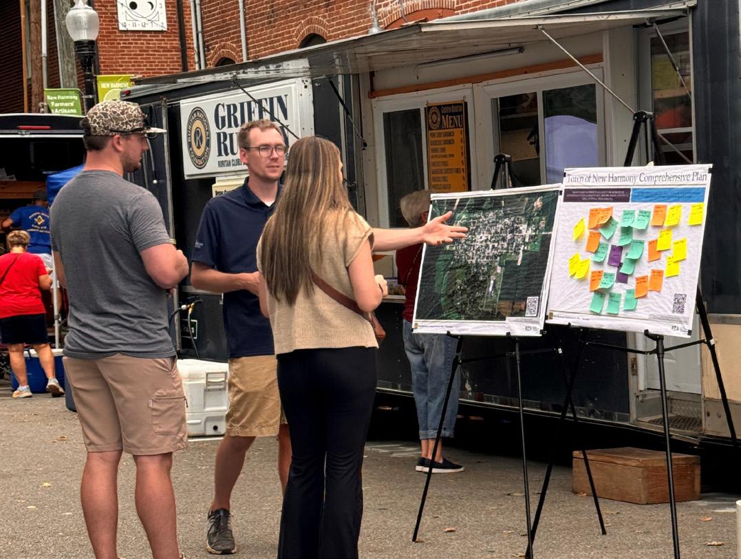
Location: Booth at Church & Main
Date: September 21, 2024
Number of Attendees:
Approximately 25-30 direct responses; conversions with many others also occurred
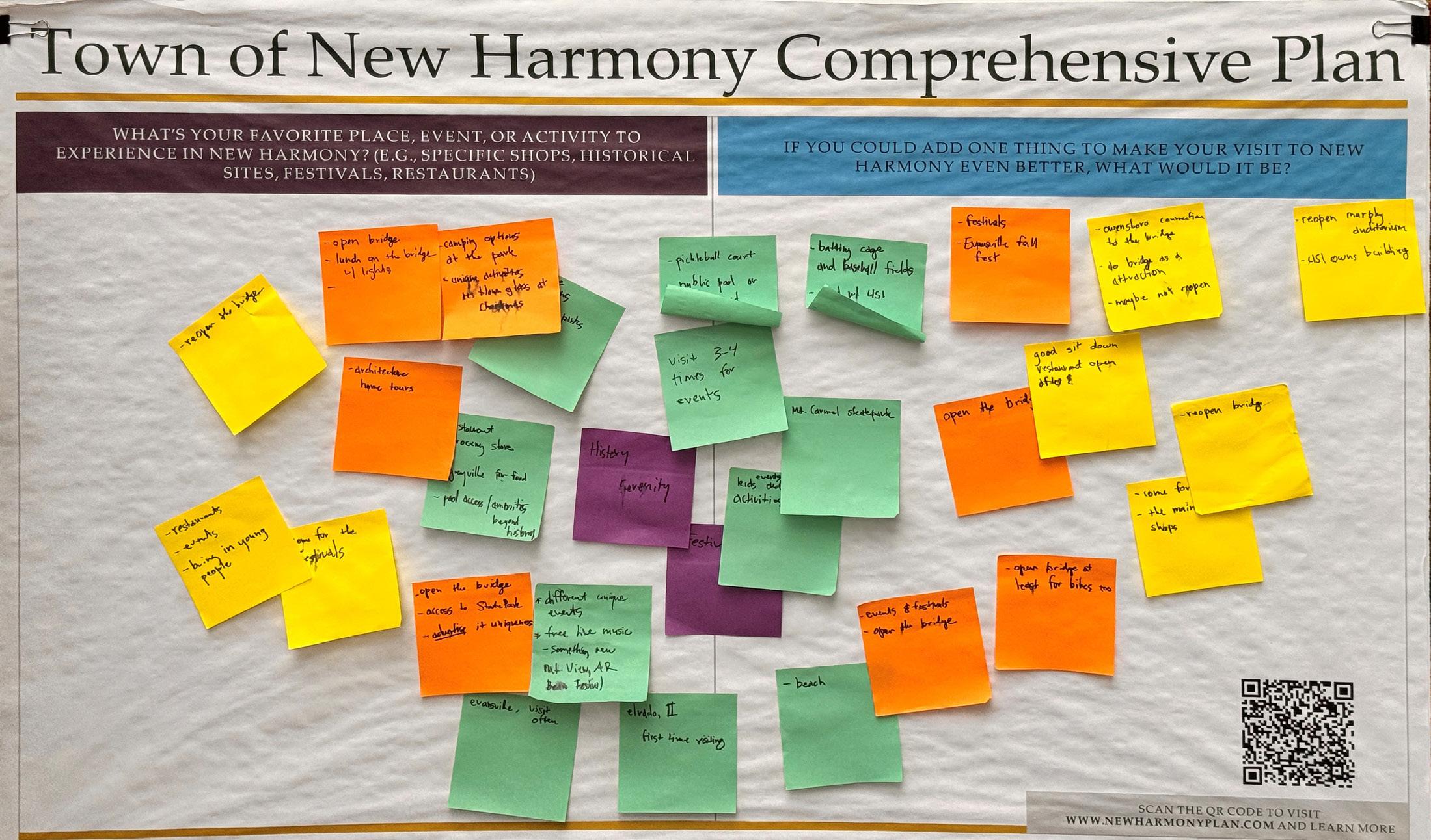
Community Planning Week
Community Planning Week took place from September 30, 2024 to October 3, 2024. The consulting team was in residence in New Harmony for focus group meetings, a community workshop, a steering committee meeting, and a community open house.
Focus Groups
The following focus groups were held during Community Planning Week:
• Real Estate/Property/Housing (5 participants)
• Previous Town Council Members (6 participants)
• Cultural Not-for-Profits (8 participants)
• Ministerial Association (5 participants)
• Blaffer and Granary Foundations (4 participants)
• Kiwanis (10 participants)
• Businesses (7 participants)
• Parks and Trails (working group for the 5-Year Parks and Recreation Plan) (9 participants)
• Young Families
• Local 8th Grade Students
Location: The Scholar’s house
Date: September 30, 2024
Number of Attendees:
More than 54 people across all focus groups.

Key themes that emerged from the focus group conversations were:
• Housing availability
• Affordable housing for young people
• Growing a sustainable business economy and resident capacity
• Maintaining structures
• Bridge repair
• Streetscape
• Community identity
• A sense of unity and community
• Vision for a clean, safe, small, natural community
• Vision for more housing, improved infrastructure and historic preservation
• Vision to remain historical and cultural
• Coordination between/organizing internal and external entities and organizations
• Cohesive programs for organizations to bring in visitors and residents
• Vibrant art community
• Information communicated through multiple methods
• Farm-to-table efforts
• Challenge is getting people to town to visit, need proper marketing
• Staffing is a challenge for the town
• Need for a school gymnasium or community facility/fitness center
• Increased family dining options
Public Workshop
The opening public workshop had 75 sign-ins on the sign up sheet but also saw participation from media, consultants, or elected officials of the town who did not sign in. Activities included an analysis of strengths, opportunities, challenges, and barriers to success; a visioning exercise; and an idea asking for one “big idea” for New Harmony.
Key comments from the first community workshop were:
• The Wabash River is an asset that could be expanded/ enhanced
• Concern about subsidized housing
• Zoning needs to be updated; the town is vulnerable without updated zoning
Location: Thrall’s Opera House
Date: September 30, 2024
Number of Attendees: Approximately 100 people
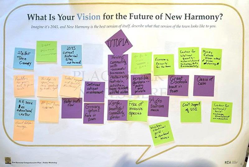
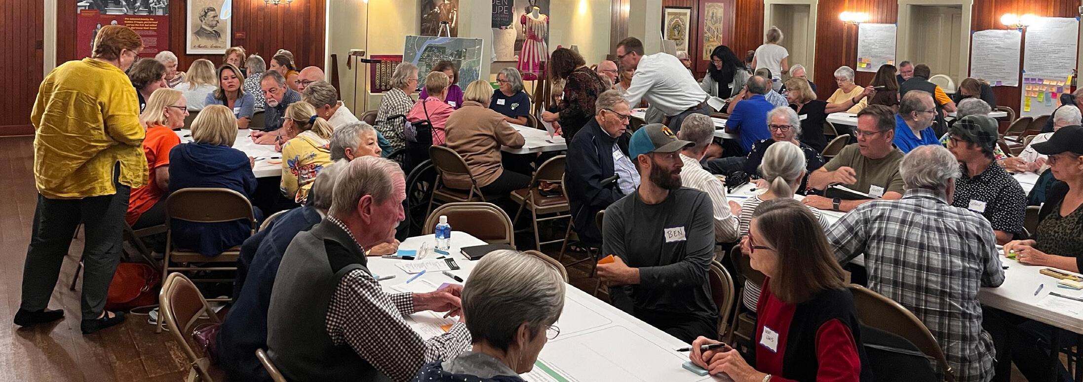
Open House
A public open house was held at the end of Community Planning Week to share the ideas generated during the week and seek input on the direction for the plan. Sixty participants signed-in for this event, though more attended. Engagement activities included housing preferences, vision and guiding principles, and draft future land use concepts.
Key comments from the open house were:
• Consistency and enforcement with zoning
• The historic district should be preserved, not adaptively reused
• Historic preservation needs to also allow for daring new design
• Trails need to be properly funded and maintained before adding more
• People can walk or use golf carts, there is no need for corner shops
• School building is an opportunity (many different ideas on use)
Location: Thrall’s Opera House
Date: October 3, 2024
Number of Attendees: Approximately 80 people
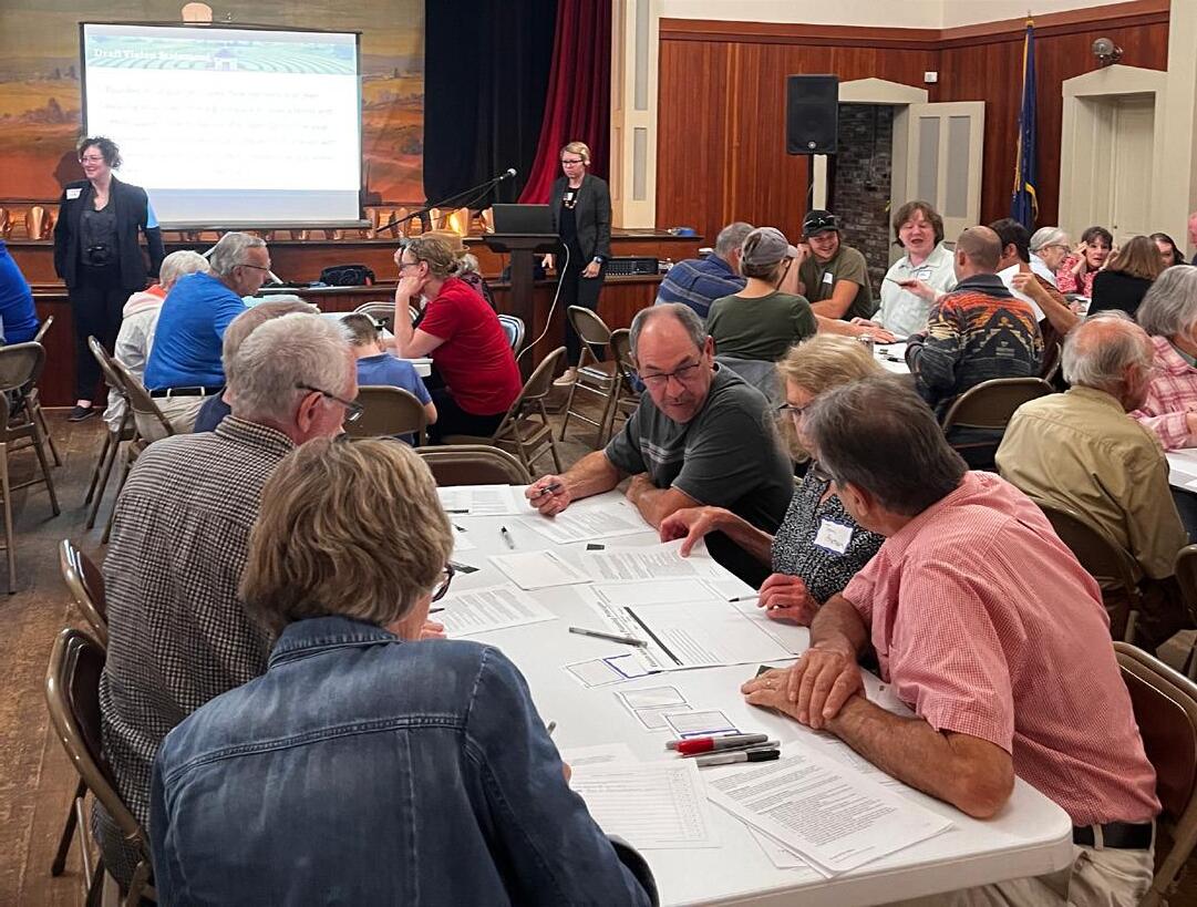

Project Webpage
A webpage was developed for the project at newharmonyplan.com to share information about the planning process, including materials from the public workshops and open house events. An interactive mapping exercise was open between Community Planning Week and mid-October as well as a resident/employee survey and separate visitor survey.
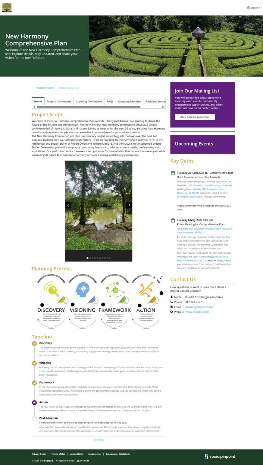
Visits: 1,268
Unique Visitors: 839
Contributions: 151
Comments on Interactive Map: 20
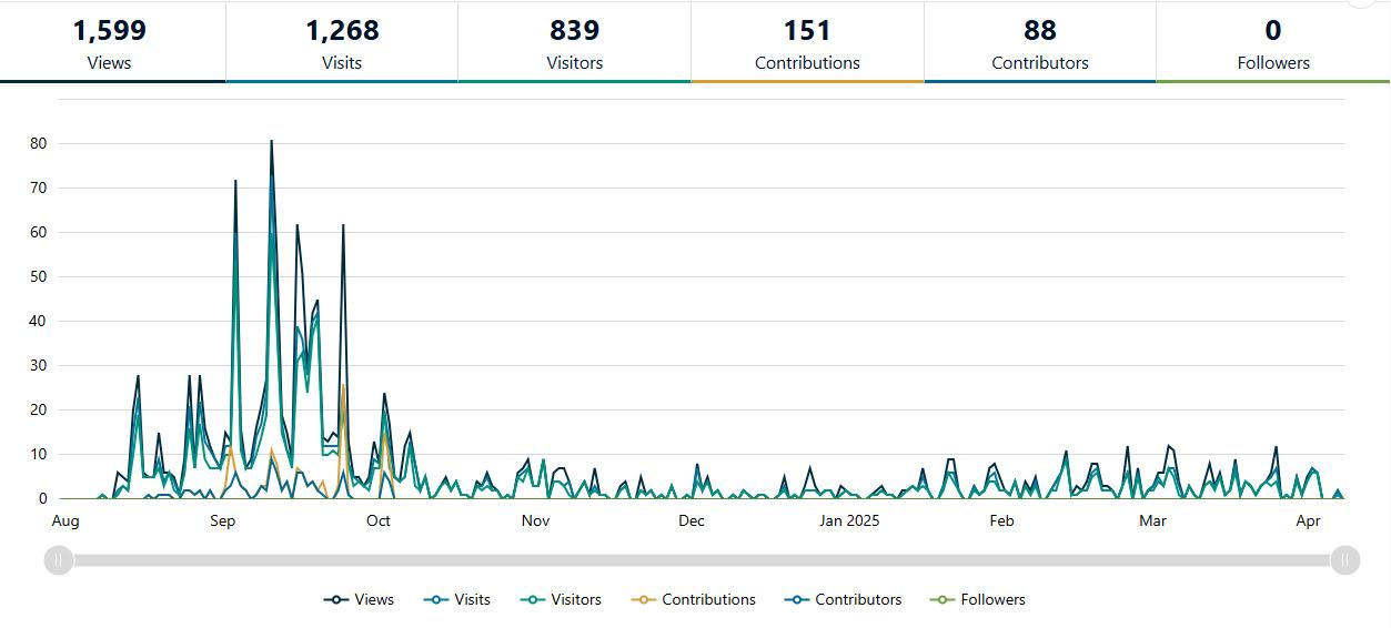
Community Open House
A final community open house included activities for the New Harmony Comprehensive plan and the 5-Year Parks and Recreation Master Plan.
Public input opportunities were provided on the vision and guiding principles, each of the plan elements, and the future land use map for the comprehensive plan.
Participants generally agreed with the vision statement and guiding principles.
Comments on the plan elements included:
• Agreement on the need for more housing, but concerns about affordability and financing for local workers and the need to prioritize infill development over expansion. A need for more information about cottage court housing and accessory dwellings.
• Strong support for enhancing local businesses and tourism while retaining New Harmony’s small town charm.
• Interest in the riverfront as a recreational and economic asset.
• Widespread support for improving sidewalks and expanding active transportation. Divided comments on the Harmony Way Bridge between vehicle transportation and bicycle/pedestrian transportation.
• Strong agreement on prioritizing infill development, preserving historic structures and natural areas, and adaptive reuse of historic buildings.
Location: Thrall’s Opera House
Date: March 19, 2025
Number of Attendees: Approximately 60 people
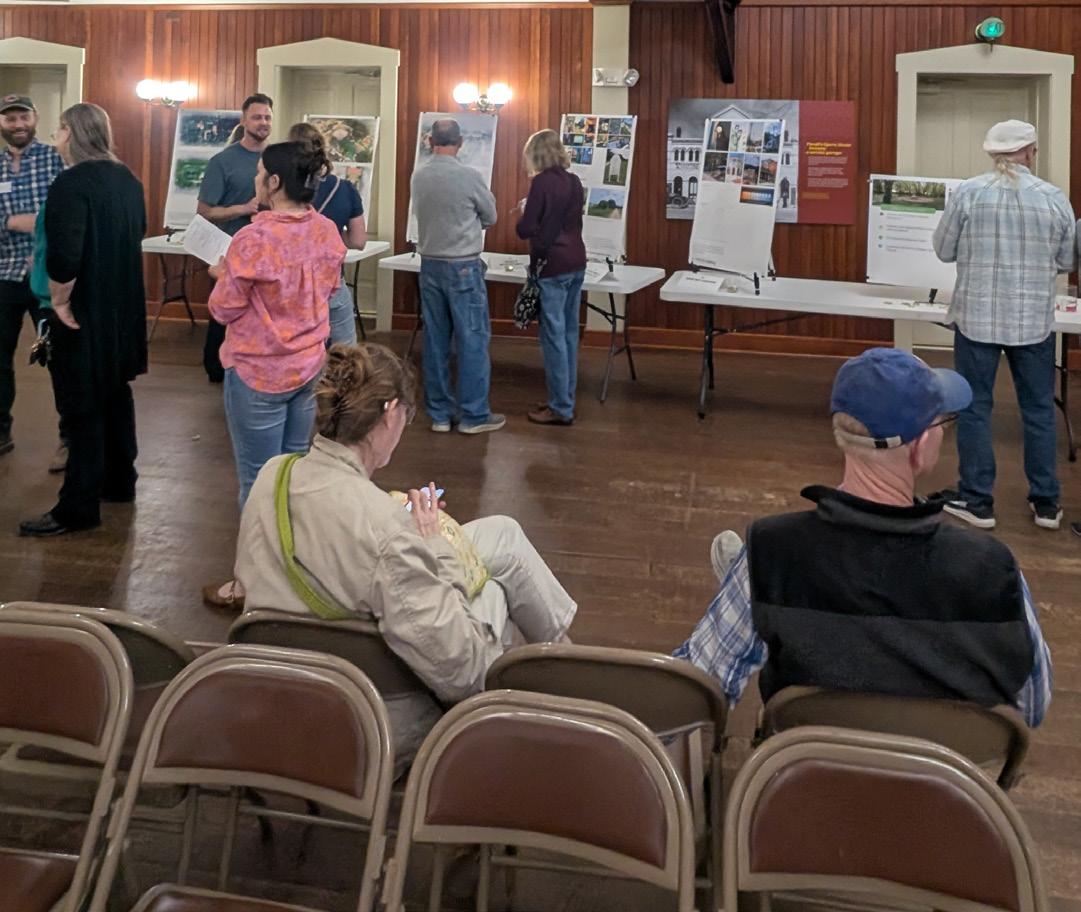
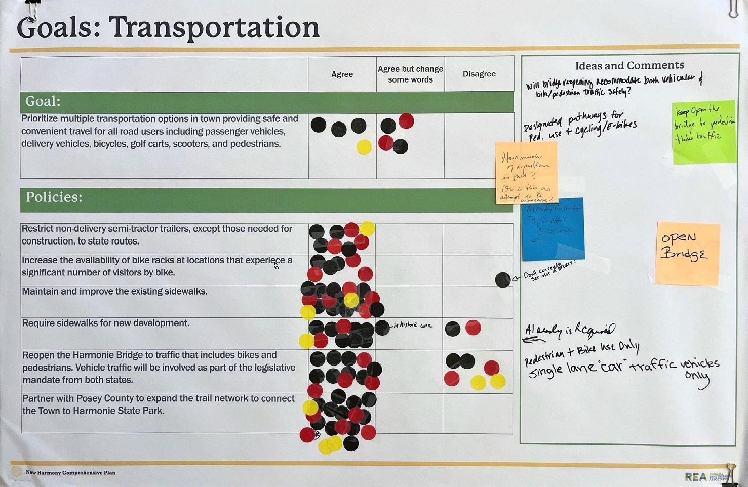
APPENDIX B: EXISTING CONDITIONS REPORT
CONTEXT AND KEY TRENDS
CONTEXT
Location
New Harmony is a historic town on the Wabash River in Harmony Township, Posey County, Indiana. It lies 15 miles north of Mount Vernon, the county seat, and is part of the Evansville metropolitan area. The Wabash River forms the western boundary of New Harmony. It is the westernmost settlement in Indiana.
Government Structure
Town Government
New Harmony has a five-member town council and an elected clerk-treasurer.
The New Harmony Plan Commission also serves as the Historic Preservation Commission. The town administers its own zoning and has a Board of Zoning Appeals.
Other service departments include the New Harmony Parks & Recreation and Tree Board, Maple Hill Cemetery, the gas and street department, and the water and wastewater department.
Posey County
Posey County is the southernmost, southwestern most, and westernmost county in the State of Indiana. Its southern border is formed by the Ohio River, and its western border by the Wabash River, a tributary to the Ohio. Posey County is part of the Evansville, Indiana metropolitan statistical area. The Ports of Indiana-Mount Vernon, on the Ohio River, is the seventh-largest inland port complex in the nation based on the tons of materials handled.
The County Council is the legislative branch of the county government and controls spending and revenue collection in the county. Representatives are elected to four-year terms from single-member districts of roughly equal population in the county. They set salaries, the annual budget, and special spending. The council has limited authority to impose local taxes, in the form of an income and property tax that is subject to state level approval, excise taxes, and service taxes.
The County Commissioners serve as the executive body of the county. The board is a three-person board of commissioners, who are elected at-large (county-wide), to staggered four-year terms. One commissioner serves as president. The commissioners execute acts legislated by the council, collect revenue, and manage the county government.
Other county elected offices include sheriff, coroner, auditor, treasurer, recorder, surveyor, and circuit court clerk. Each serves a four-year term.
The county has an Area Plan Commission that serves as the plan commission for unincorporated Posey County, Poseyville, and Cynthiana.
KEY TRENDS/ISSUES
Regional Context
Posey County is in the Evansville Regional Economic Partnership region in southwestern Indiana (E-REP), which works closely with the Southwest Indiana Regional Development Authority for initiatives like the Indiana Regional Economic Acceleration and Development Initiative (READI) program. The county is also part of the Evansville Metropolitan Planning Organization area, but outside the urbanized area.
Assessed Value and Property Taxes
The total assessed value for the Town of New Harmony for 2024 was $37,440,905. The state approved a budget of $693,847 for the town from local property taxes. The tax rate for the Town of New Harmony is 2.43 per $100 of assessed valuation (AV). Taxes outside of the town, in Harmony Township are $1.75 per $100 of AV. Relative to other incorporated communities in Posey County the local tax rate is lower.
Declining Population
The town population has decreased from its high of approximately 1,400 in 1940 to approximately 700 in 2020. The population forecast for 2030 shows the population will decline by another 100 residents. There are few families in New Harmony and without a nearby school or child care it is challenging to attract families to the community for population growth.
High Expectations of Local Government
The town government is operated largely by residents who have been elected to Town Council, as Clerk-Treasurer, or serve on appointed boards and commissions. This requires elected and appointed officials to volunteer may hours and learn complex state and federal processes and regulations in addition to hiring staff or vendors to maintain the water and sewer system; the roads, trails, and sidewalks; the park facilities; police; and similar functions of government. Many residents have lived in larger communities with more resources – both funding and personnel –to manage the day-to-day operations of the government.
Tourism Economy
Residents noted that the local economy was based in tourism and is visitor dependent. Others noted that the community is an authentic destination and that the Wabash River needed to be more focused on as part of the New Harmony experience. Some residents have noted the divided ownership/management of cultural assets. Twenty-six visitor surveys were completed as a part of the engagement process. Observations included:
• “I had no idea New Harmony is a destination town. It would benefit from more statewide marketing.”
• “I loved that I could rent a golf cart. It allowed me to see a lot in the short time I was here and was oh so fun!”
• “Enjoyed our visit. Will return. More info on social media. We only heard about it through friends.”
• “Would come and stay for several days – take a class.”
Historic New Harmony is a program of the University of Southern Indiana (USI). In 1985, the University of Southern Indiana assumed management of Historic New Harmony, creating cultural and educational programs, while maintaining historic properties. Within the USI Foundation, the Historic New Harmony Advisory Board supports the mission of Historic New Harmony.
The Indiana State Museum and Historic Sites plays a major role in the ownership and preservation of New Harmony’s historic properties. As part of the Indiana state government’s historic site system, the museum manages several important properties in the town, ensuring their upkeep and accessibility. The Indiana State Museum also offers community tours in New Harmony.
Floodplain
Residents expressed concern that changes to Indiana floodplain definitions could hinder building and adding on to existing buildings in the community and that there are existing homes in the floodplain that are difficult to sell because of the cost of flood insurance. Others expressed concern about flooding itself.
According to the Indiana Floodplain Information Portal 2.0, significant portions of New Harmony are in the floodplain of the Wabash River. There are areas that are within the corporate boundaries, not yet developed, that are outside the floodplain. Most notably on the south and east sides of the community. The designation that applies to areas in New Harmony is Zone A and AE. The Federal Emergency Management Agency (FEMA) Zones A and AE are high-risk flood zone with a one percent annual chance of flooding, or a 26 percent chance of flooding over the life of a 30-year mortgage. The difference between Zone A and AE is that AE has base flood elevations provided. Construction in the floodway area requires a permit from the DNR, Division of Water. Local floodplain ordinances require local construction permits. Flood insurance is strongly recommended and may be required by FEMA. Under the federal regulations of FEMA, the National Flood Insurance Program (NFIP) requires the purchase of flood insurance on buildings in the FEMA mapped Special Flood Hazard Area (Zones A, AE, AH, AO, AR, A99, or VE) that have a federally backed mortgage.
The mapping process is underway in 2025.
Bridge
Some residents expressed a desire for the Harmony Way Bridge to be open to bike and pedestrian traffic, others suggest passenger vehicle traffic without heavy trucks, and others suggest a new bridge that can accommodate farm equipment. The most common desire expressed is for the bridge to be opened to bikes and pedestrians.
The bridge carried US 460 from 1947, though it had opened in 1930, until the highway was decommissioned in 1974. The bridge is currently owned by the White County Bridge Commission. In 1941, Congress created the White County Bridge Commission as a joint Illinois-Indiana agency to purchase the bridge from the Big Wabash Bridge Company which had been chartered by Congress to build the bridge. The next bridge upstream is I-64, which does not allow farm vehicles and the next bridge downstream is the Wabash Memorial Bridge in Mount Vernon, approximately 15 miles south of New Harmony. On May 21, 2012, it was announced that the bridge would close permanently at noon on May 29, 2012. An effort to fund repair was made in 2021 but lacked support from the Indiana congressional delegation.
The Harmony Way Bridge is jointly owned by the Wabash River Bridge Authority in Illinois and the New Harmony and Wabash River Bridge Authority in Indiana. The Harmony Way Bridge is on the National Register of Historic Places. Currently both states (Indiana and Illinois) have established a commission to study the viability of the bridge with the goal of reopening it to at least one lane of vehicle traffic, with the potential for pedestrian and bike uses. Additional engineering studies will be conducted in 2025.
School Property
Residents expressed concerns over the future of the school property.
New Harmony Town and Township Consolidated Schools was a school district headquartered in New Harmony, Indiana. It operated one school, New Harmony School, with grades Kindergarten through 12. In December 2011, the board of education chose to close the K-12 school. The New Harmony town council paid $10 and acquired the school building. In 2019, an individual acquired the school building from the town council for $125,000 and stated a desire to preserve its historic character. A developer purchased the property in 2024. The community believes that there will be a proposal for residential development on the site.
PEER COMMUNITIES BENCHMARKS
Peer communities for New Harmony are Colfax, Cynthiana, Kirklin, Shoals, and Nashville, Indiana. Nashville is a larger community but has a similar unique quality with their arts colony. Peer communities are typically similar in size, location or natural attributes, history, or unique characteristics. Some of the peer communities also have one or more properties or districts on the National Register of Historic Places.
CONTEXT
Colfax
Colfax is a town in Clinton County, Indiana. Colfax was laid out in 1849 by Montgomery Stroud. It was originally named Midway for its position between Chicago and Louisville along the IC&L railroad. In 1853 the town gained a post office named Colfax, and in December 1857 the name of the town itself became Colfax, by petition of the residents. The Colfax Carnegie Library and Rosenberger Building are listed on the National Register of Historic Places.
Cynthiana
Cynthiana is a town in Posey County, Indiana. Cynthiana was named for Cynthiana, Kentucky, from where a group of settlers had come in 1815. More settlers from the same area continued to migrate to the area over the following several years. On March 6, 1817, the town was laid out by William Davis, with the plat recorded in March 1817. It was not until April 22, 1896, that the town incorporated. A post office has been in operation at Cynthiana since 1820.
Kirklin
Kirklin is a town in Clinton County, Indiana. Nathan Kirk, the first white settler in eastern Clinton County, laid out the town of Kirklin in the early 1830s, the original plat consisting of a row of seven blocks on either side of the Michigan Road (Main Street). An addition in 1836 added blocks to the east, west and south sides of the original plat. The town was incorporated in 1876. The Kirklin Public Library was listed on the National Register of Historic Places in 1995.
Shoals
Shoals is a town in Martin County that serves as the county seat. Shoals is best known for the Jug Rock, the only free-standing table rock formation east of the Mississippi River. Shoals was originally called Memphis and was platted in 1844. The post office at Shoals has been in operation since 1869. The East Fork of the White River flows through the center of town, running south and west to join the White River northeast of Petersburg.
Nashville
Nashville is a town in Brown County, Indiana. The town is the county seat of Brown County and is the county’s only incorporated town. The town is best known as the center of the Brown County Art Colony and as a tourist destination. The first Nashville courthouse was constructed in 1837 and a jail was added in the same year. The town was officially incorporated in 1872. In the early twentieth century, several artists settled in the area, most notably T. C. Steele, the American Impressionist painter. These artists were the basis for the Brown County Art Colony, which continues as the Brown County Art Guild. The Brown County Courthouse Historic District and F.P. Taggart Store are listed on the National Register of Historic Places.
PEOPLE AND HOUSEHOLDS
Population
The population of the peer communities is similar, and all except Nashville have experienced a shrinking population between 2000 and 2020. Nashville grew 46 percent in that time and in 2020 had a population of 1,256. Proximity to the Indianapolis metro region has supported Nashville’s growth, though Colfax and Kirklin are closer to Indianapolis and have not experienced population growth. The natural beauty of Brown County and the Nashville community itself have also supported growth. Prior to 2010, Nashville had also been declining in population after growth in the 1980s.
Age
Over time the median age in Nashville and New Harmony has increased and is higher than the state median. Both New Harmony and Nashville had a median age over 50 in 2020, though the median age in New Harmony had come down some between 2010 and 2020, while it increased by 7 years in Nashville during that time. Colfax, Kirklin, and Cynthiana have a median age closer to the statewide median, falling in the mid-30s. Shoals population aged between 2010 and 2020 from under 40 to nearly 57. Communities with rapidly increasing median ages are not generally supporting children or attracting young adults. Risk factors of an older community are the disposable income of households, the need for social and medical services, the ability to sustain local schools, and the ability to cultivate and sustain local businesses and organizations.
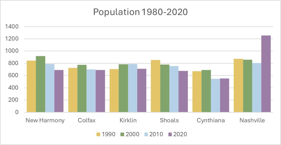
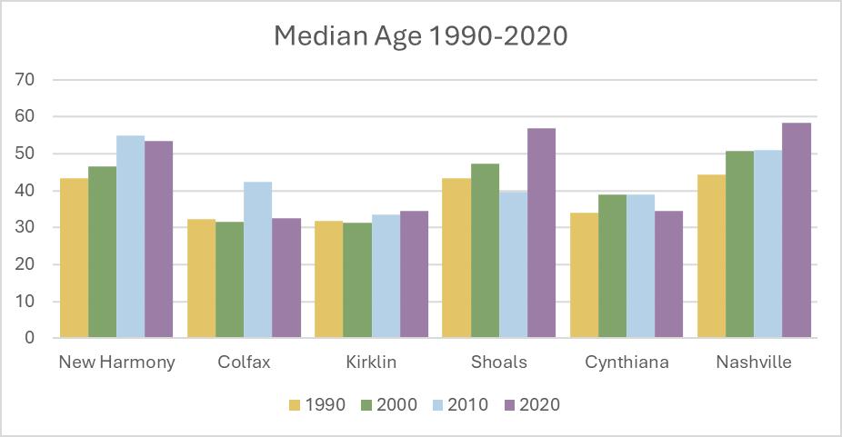
Households
The number of households and the housing units needed for those households can vary significantly by household size. There has been a general reduction in household size over the past two decades that has changed housing assumptions. In a community with a stable household size and no population growth, a need for new housing would not be anticipated. But if the household size decreases due to changes in household structure, more housing would be needed for the same number of people. A typical household from a generation or two ago consisted of two adults and approximately two children living in one house. If the adults separate, there are now two housing units needed for the same people who lived in one previously. When a child grows, if they stay in the community, they will also want a home of their own.
Nashville has experienced growth in households that aligns with its population growth. Kirklin and Colfax have experienced more modest increases in the number of households, while households in New Harmony have declined.
Of the peer communities, only Colfax and Cynthiana have experienced an increase in the average household size between 2010 and 2020. Communities with older heads of household tend to have a smaller average household size as adult children have moved away or partners have passed away.
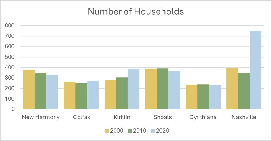
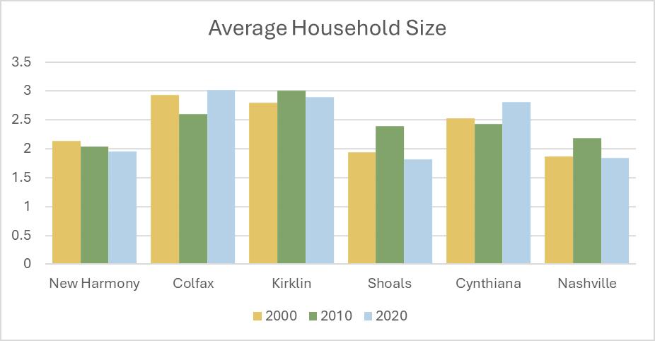
Families
The Census defines a family as a group of two or more people living together who are related by birth, marriage, or adoption. Family households may include people who are not related to the family living with the family. Married couples are families, as are single householders with one or more children of their own living at home. New Harmony’s peer communities have different experiences with changes in the number of families, in part related to the change in population. Kirklin and Nashville have seen the greatest increases in the number of families, while New Harmony and Shoals have seen the biggest decreases.
The average family size is generally larger than the average household size because by definition a family includes two or more people. In New Harmony the average household size is below two, but the average family size is over two and a half.
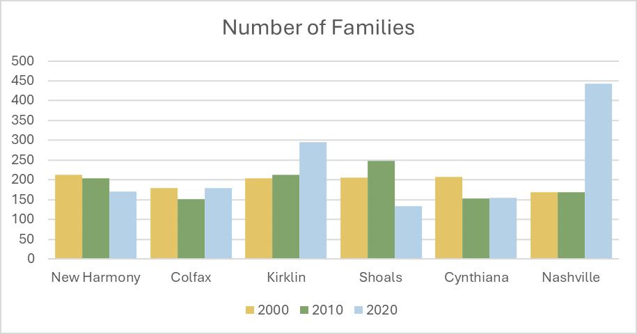
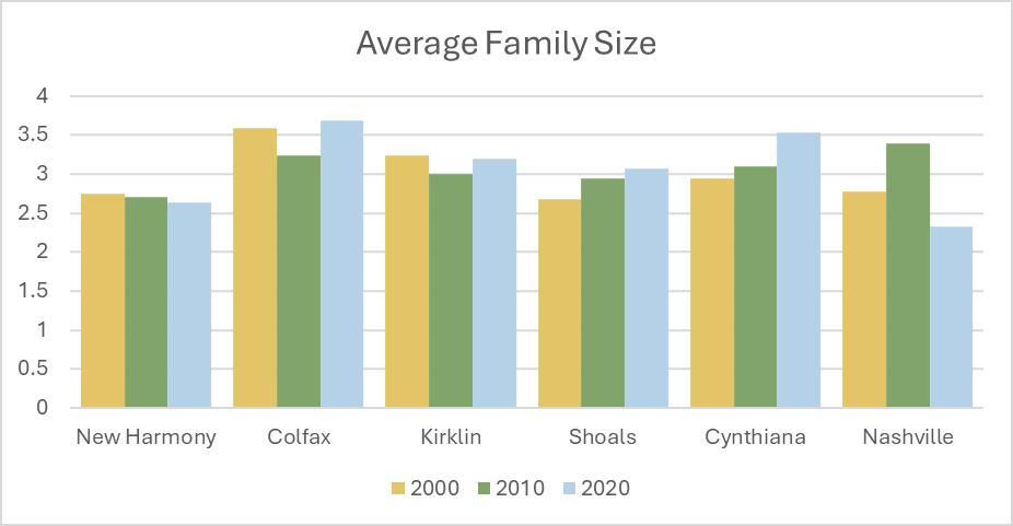
BUILT ENVIRONMENT
New Harmony and many of its peer communities have mostly residential uses comprising their built environment other than their transportation infrastructure. Housing is the focus of the comparison between the peer communities.
Housing
Some of the peer communities, in addition to New Harmony, lost housing units between the 2010 and 2020 Census. This could be a data collection error from 2010 or houses were lost in the communities due to flooding, fire, or other demolition. The only peer community with significant housing growth in the period was Nashville, which has also experienced population growth.
In all the peer communities most housing units are owneroccupied. Nashville has seen steady growth in rental units in addition to owner-occupied units between 2010 and 2020. The housing and banking market crash in late 2008 that led to the Great Recession explains why some communities had a loss of owner-occupied units between 2000 and 2010 – people lost their mortgages in the banking crisis or were not able to convert their loans into fixed rate mortgages when their adjustable-rate mortgages were reset.
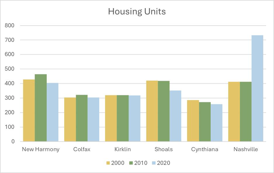
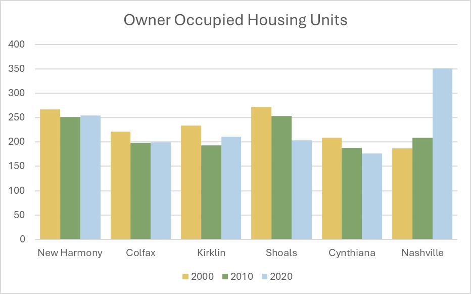
WORKFORCE AND ECONOMY
The number of jobs, commuting patterns, and educational attainment of workers, as well as median household income, provide insight to the local economy function.
Employment
The workforce, residents who live in a community and work, regardless of where they work is one measure of the local economy and is tied to population and population age.
The other way to look at employment is how many people work in the community, even if they do not live there. New Harmony (261) has a similar number of jobs to Kirklin (284) and Cynthiana (270), more than Colfax (36), and fewer than Shoals (382) and Nashville (501).
The largest employment sectors for jobs located in New Harmony are Accommodations and Food Service (36 percent) and Health Care and Social Assistance (34 percent).
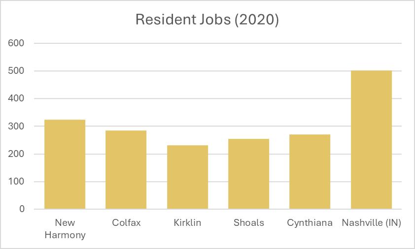
On the Map (Census)
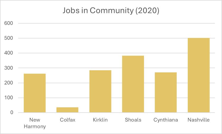
Commuting
In the peer communities only, a small number of people both live and work in any community; most have a smaller number of workers coming in from other communities to work and a larger number of residents leaving the community to work elsewhere. For opportunities to capture spending from people who are in the community during the day, it is important to understand these work travel flows. Local income taxes are paid to the county of residence rather than the county of work, which means it is beneficial to Posey County if people who live outside the county work inside the county. Local option income taxes like the County Adjusted Gross Income Tax (CAGIT) or the County Option Income Tax (COIT) or the County Economic Development Income Tax (CEDIT) are smaller shares than that paid to the state, however. Also, they are county revenues, rather than municipal revenues. Property taxes still make up the largest share of local government revenue.
One unique situation among the smaller peer communities is the number of workers who come into Shoals for work. US Gypsum and National Gypsum are large employers in Martin County and are both located in Shoals. Significantly more workers come into Nashville than leave as well, but Nashville is a larger community and has employers like the state park, inns and resorts, as well as large education, religious, and health care employers.
Inflow is the number of people coming into the community to work, outflow is the number of people leaving the community to work.
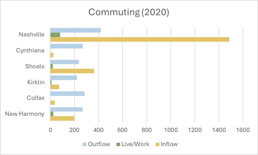
Source: On the Map (Census)
Household Income
The median household income for all communities across decades has been adjusted to 2020 dollars, making the 2010 and 2000 numbers comparable to 2020. Household income is one of the indicators that businesses use, along with rooftops, to determine if there may be sufficient market for them to locate in a community. Median household income is also connected to the home value that people can afford, meaning that they spend less than 30 percent of their income on housing costs and less than 45 percent of income on housing and transportation combined.
Most of the peer communities experienced real income growth between 2010 and 2020, with New Harmony and Kirklin being the exception. However, New Harmony income remained generally flat, while Kirklin experienced a decline in real median household income. New Harmony also did not lose ground on median household income in the aftermath of the Great Recession as much as some peer communities.
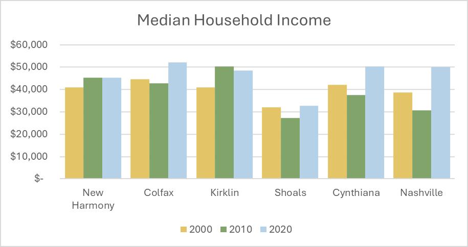
2000 Decennial Census (PCT039), 2010/2020 ACS 5-Year (S2503)
Jobs by Earnings
For the people who work in the peer communities, regardless of where they live, the wage levels tell another part of the story since not all income is from employment earnings. The percentage of jobs with earnings over $3,333 per month (approximately $40,000 per year) is highest in Cynthiana and Kirklin and lowest in New Harmony.
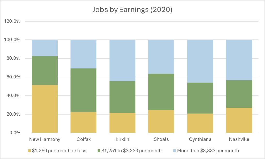
Source: On the Map (Census)
Educational Attainment
For residents who work, regardless of where they live, educational attainment is consistent across the peer communities. Cynthiana has a larger percentage of young workers who are not included in the data, as does Kirklin. Kirklin has a smaller percentage of residents who work and have college degrees, while Nashville has a larger share of college-educated residents who work.
For those who work in the communities, regardless of where they live, the educational attainment speaks to what level of training is needed for local jobs. In the peer communities a college degree is not needed for employment in most cases. In communities where there are schools and/or medical facilities there are more workers who have degrees because they are required to teach and work as a medical doctor or dentist.
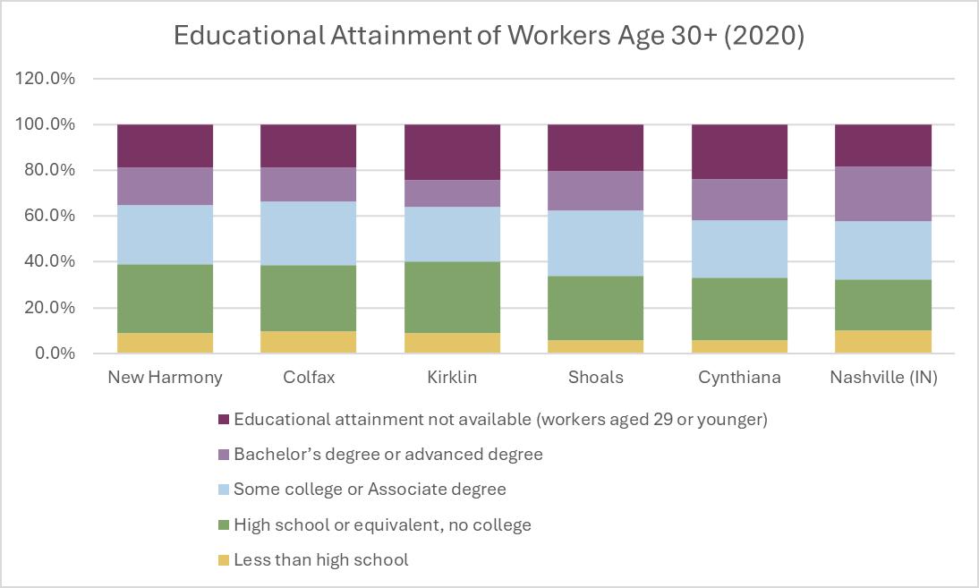
Source: On the Map (Census)
NATURAL ENVIRONMENT
The natural environment of New Harmony has shaped its past and is part of why people are currently drawn to the area to live and visit. The Wabash River is the defining natural feature of the community and how settlers arrived in the area over time. Hillsides frame the southern boundary of the community and connect into Harmonie State Park. New Harmony played a significant role in the study of geology in Indiana and across the United States.
WABASH RIVER
The Wabash River forms the western boundary of the Town of New Harmony. Further south in Posey County is where the Wabash River converges with the Ohio River. The river flows freely for 411 miles south of the dam at Huntington, Indiana.
The name of the river comes from the river’s natural limestone bottom up near Huntington, which is largely obscured by sediment along the river’s corridor. The river has officially been recognized as the state river for Indiana. While now considered a tributary of the Ohio River, until the mid-18th century the Ohio River was considered a tributary of the Wabash. During the 19th century the Wabash was navigable by large ships between Terre Haute and the Ohio River.
The river flows primary west from its headwaters in Ohio to the City of Covington, where it turns south and widens as it moves south. The Wabash is joined by its largest tributary, the White River, near Mount Carmel, Illinois. Further south the Patoka River meets the Wabash. New Harmony is between natural enclaves in the river between Indiana and Illinois.
The Wabash follows the path of the pre-glacial Teays River. The river has shifted course several times along the Indiana and Illinois border, creating cutoffs where parts of the river are entirely in either Indiana or Illinois. However, both states generally regard the middle of the river as the state border.
The Wabash River floods and has a significant impact on development in New Harmony. The flood maps are under revision to better reflect the current risk levels.
HILLSIDES AND RAVINES
Harmonie State Park is located south of the Town of New Harmony. One of the defining features of the park is its steep ravines that were carved by glacial meltwaters at the end of the last ice age. These hillsides and ravines start just south of the town boundary and continue into and throughout the park. Residents have expressed appreciation for the beauty of the hillsides.
GEOLOGY
New Harmony holds a special place in the study of geology – not so much for the geology of the town and the surrounding areas as for the influence residents had on the field at the state and federal level. The name “New Harmony Group” has been given to subsurface lower Devonian rocks that were identified in the Ford Well in White County, Illinois, which is near New Harmony. The rock group consists of two basic kinds of mostly pale carbonate rocks.
David Dale Owen was trained as a medical doctor, but after returning to New Harmony was influenced by William Maclure and Gerard Troost (a Dutch geologist). Owen went on to become the state geologist for Indiana and conducted the first official survey of Indiana between 1837 and 1839. He became the US Geologist in 1839 and led federal surveys in the Midwest. He was the first state geologist in three states (Kentucky, Arkansas, and Indiana). His museum and lab in New Harmony were the largest west of the Allegheny Mountains. Some men in his circle of influence went on to become prominent geologists and for a brief period of time the Illinois State Geological Office was headquartered in New Harmony.
BUILT ENVIRONMENT
The built environment refers to all structures, places, and systems that have been built to support people living in and visiting the community. This includes a variety of land uses, housing, historic districts and structures, and the transportation system.
LAND USE
Land uses are typically described by their primary function and land use categories often apply to large areas of a community even if there are small buildings or structures that are not of the same function or have mixed functions (like apartments over commercial spaces). Land use is not the same as zoning classification, which is the use assigned on a parcel-by-parcel basis that determines the regulations governing how that parcel can be developed including use, setbacks, building height, and in some cases materials or design.
Residential
Residential land uses include single-family homes, live-over-work spaces, townhouses, and apartments. It applies whether the building is owner occupied or renter occupied. Renter occupied residential uses may be long-term rental (typically a year or longer lease) or short-term rental which may be overnight or up to a few months. Residential uses contribute to the local property tax base at a lower level than commercial or industrial uses unless they are non-homestead (rental) properties.
Commercial
Commercial land uses include retail, service, and similar operations where transactions between the business and customers is done in person or by mail/internet. Restaurants, retail shops, and professional services are the primary uses in the downtown area. Hotels and nursing/assisted living facilities are also considered commercial land uses.
Downtown and historic area commercial uses have a different character than more suburban commercial uses like gas stations and convenience stores.
Commercial uses contribute more to the local property tax base than residential uses.
Industrial
Industrial uses include manufacturing, fabricating, assembly, warehousing, and distribution/ logistics. These are often uses that have larger lots and may have heavy truck access for material delivery or shipment. They are employers in the community, providing jobs for people who live in town or commute from the surrounding areas. Industrial land uses contribute more to the local tax base than residential uses.
Industrial uses are fairly limited in New Harmony and are primarily adjacent to Church Street/SR 66 on the northeast side of the community.
TRANSPORTATION
Non-Profit/Institutional
Non-profit and institutional uses are treated differently than some other primary land uses. The difference between a non-profit and a for-profit is largely tax base related as non-profits don’t pay property taxes. Institutional uses like schools, places of worship, most parks, and some community buildings also generally don’t pay property tax but have special roles and impacts on the community. Traffic circulation, parking, and emergency response for these places is different than some of their residential, commercial, or industrial counterparts. Often places of worship, schools, and parks are located within residential neighborhoods. They may be a special use or a permitted use within residential zoning districts rather than a stand-alone district, though some communities use that approach.
Examples of non-profit or institutional uses in New Harmony include town hall, the parks, churches and other places of worship, and anything owned by the University of Southern Indiana, the State of Indiana, or a community foundation with non-profit status.
Parks and Open Space
Murphy Park
Murphy Park is one of the central recreational spaces in New Harmony, Indiana, offering locals and visitors a peaceful, scenic retreat. Known for its welcoming, family-oriented atmosphere, Murphy Park serves as a hub for outdoor activities, community events, and leisurely relaxation. Among its many features is Playtopia, a large and vibrant playground that has become a favorite spot for children and families alike. Playtopia is a creatively designed playground with various play structures that encourage physical activity, imaginative play, and social interaction.
Maclure Park
Maclure Park is a community park named after William Maclure, a prominent geologist and philanthropist who was instrumental in the town’s early utopian experiment. The park provides a scenic and welcoming space for recreation and relaxation, with facilities that include playground equipment, picnic areas, and a bandstand.
Roads and Bridges
State Road 66 is known as Church Street in town and is the main east-west road in the community core. The road is maintained by the State of Indiana Department of Transportation. As such the state also regulates the uses of the road. Heavy trucks are allowed to use Church Street, but golf carts are not permitted on the road as the state does not recognize them as vehicles. Since the closure of the Harmony Way bridge there is less incentive for heavy trucks to use Church Street unless they are making local deliveries and most truck traffic bypasses town to cross into Illinois on the interstate. Heavy vehicles are not permitted on local roads by town ordinance. The town does require golf cart drivers to be licensed, register their carts with the town, and have insurance.
State Road 69 is the New Harmony bypass and it routes traffic east of town to I-64 north or Mount Vernon south. It intersects with SR 66 northeast of New Harmony’s boundary.
Main Street is the primary north-south road in the community. South of the town boundary it splits into Old Dam Road (secondary) and Maple Hill Road (primary). Old Dam Road leads to Harmonie State Park, while Maple Hill Road connects to SR 69 north of Harmonie State Park.
Traffic Counts
Two locations that are related to New Harmony vehicle traffic have average annual daily traffic counts (AADT) from the Evansville MPO: Main Street south of Church Street and SR 69 south of Church Street. The counts are measured north/east and south/west. These counts were conducted in October 2023.
Both locations have nearly the same traffic volume in both directions. Main Street has a flashing signal at Church Street and striped pedestrian crossings in all directions. There are no pedestrian crossing signals. Church Street is also known as SR 66. Where SR 69 crosses Church Street/SR 66 is a highway intersection. There is a flashing signal on SR 69 and a stop sign at SR 66. East of SR 69, Church Street becomes a driveway to a residence/farm. There are no marked pedestrian facilities. Both roads have wide shoulders at the intersection.
Truck Traffic
The same intersections have truck counts separated from the total AADT. For Main Street there are 24 trucks per day south of Church Street. SR 69 has 997 trucks per day.
Functional Classification
Functional classification is a system that is used at the local, regional, state, and national levels to identify a type of roadway and determine maintenance schedules and available funding for construction and major road preservation. Classifications range from local roads and streets to collectors and arterials, through the interstate highway system. Collectors and arterials may be further classified as minor, major, or principal. The Evansville MPO maintains classifications for the regionally significant roads. In New Harmony this includes Church Street, Main Street, and SR 69. Church Street is classified as a minor arterial, Main Street as a major collector, and SR 69 as an “other Principal Arterial” (non-interstate highway).
Harmony Way Bridge
The Harmony Way Bridge is closed and to cross into Illinois vehicles must use SR 69 to I-64 West to cross the Wabash River. Currently working through a newly appointed bi-state commission, the bridge is undergoing engineering studies to determine the feasibility of reopening to at least one lane of vehicle traffic and potentially bicycle and pedestrian traffic.
Sidewalks
Sidewalks exist in most of the developed area of New Harmony. Many of the segments are in poor repair or have been impacted by tree roots pushing them up. The town has a sidewalk ordinance that requires property owners to maintain and repair/replace sidewalks on their property at their own expense. Walking through the community on sidewalks is one of the primary ways visitors move around the community aside from golf carts.
Trails
The trails in New Harmony are crushed limestone and primarily exist along the river to the west and through undeveloped areas north of town with connections back to the downtown core. They are shared use between pedestrians, cyclists, and golf cart users. There is a southern trail near Murphy Park.
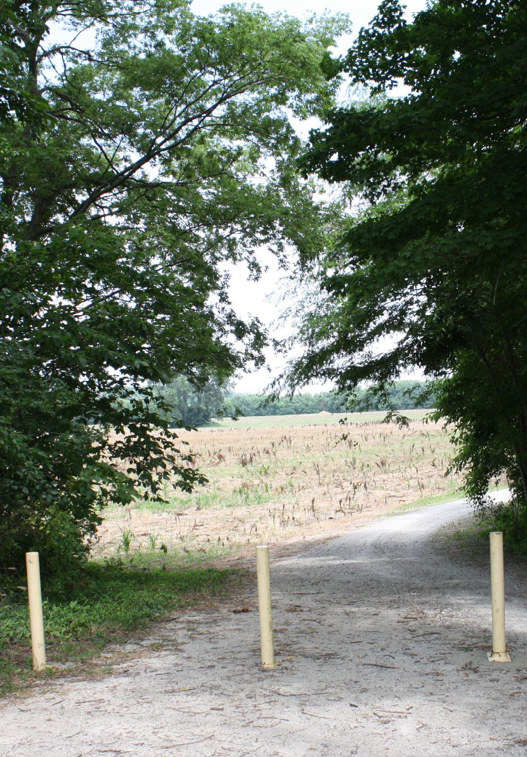
PEOPLE AND HOUSEHOLDS
Population is defined as the number of people residing in a specified area at a given time. By understanding how New Harmony’s residents have changed over time, the town can prepare for its future needs and promote healthy growth that aligns with the community vision.
POPULATION
Population Density
New Harmony is a small town, covering less than one square mile, totaling approximately 512 acres. With a population of 690 residents in 2020, the town has a population density of approximately 1.4 people per acre.
Changes by Decade
According to U.S. Decennial Census Data, New Harmony’s peak population was in 1940 with 1,390 residents. The town has declined every decade, with a slight increase in 2000, then dropping to its smallest at 690 people in 2020. It is projected by the Census Bureau to fall by another 100 residents by 2030 based on trends since 2000.
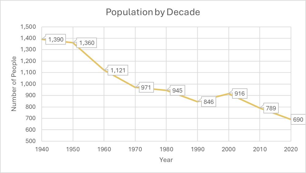
Source: Stats Indiana Decennial Population Counts
Population by Age
In 2020, the largest portion of the population is people 65 years and older, at 42 percent. This is well above the national average of 16 percent as of 2020. An aging population can contribute to shrinking population if new residents are not attracted to the community or enough of the population is not in their childbearing years and interested in raising families in the community.
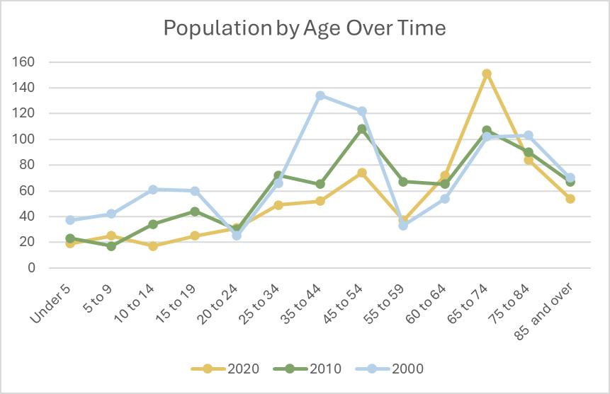
The age distribution of a community is typically largest in the working years (ages 25 to 64), with a smaller population age 20 to 24 unless there is a university, and then larger groups of schoolaged children. As seen in the age pyramid, this is not the case for New Harmony, where the largest groups are generally over age 45 and the most significant groups are older than the typical working years. The small number of school-age children both reflects that there isn’t a school in New Harmony for children to attend so families aren’t attracted to the community, and that the schoolaged population is too small to support a school.
The current largest age group is ages 65 and older, the majority of those being age 65 to 74. The most represented generation is the Baby Boomers. The town has not attracted a large population of Generation X or Millennials, who are the strongest workforce groups currently. Generation Z has entered the workforce but is also a small percent of the population in New Harmony. There are not a significant number of children in New Harmony that may stay in the town or return to raise families.
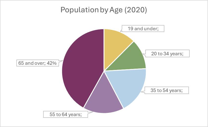
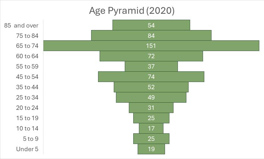
Population by Sex
In 2020, there were approximately 100 more women than men living in New Harmony—a 56 percent female and 44 percent male distribution. Indiana had a more typical distribution of 51 percent female and 49 percent male the same year. Women generally outnumber men, but in most communities the percent difference is small. The small population of New Harmony increases the percent difference but there is a difference of more than 100 people.
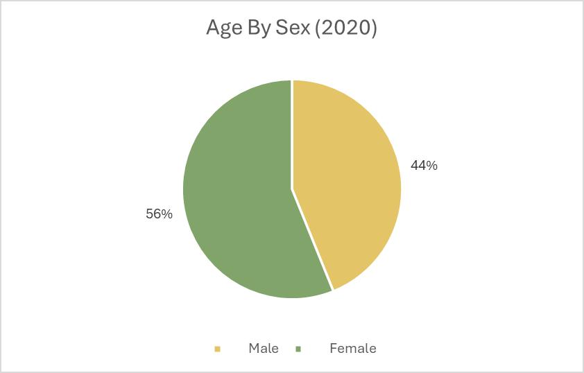
Educational Attainment
Educational attainment for adults in New Harmony has risen and fallen over time. The percentage with less than a high school diploma has decreased by 12 percent since 2000, as has the percentage with some college education but no degree. The percent of those with a bachelor’s degree nearly doubled between 2010 and 2020 from 9.8 percent to 17.9 percent. However, the small population of New Harmony means that this is a change of only a few people. Graduate and professional degree attainment has decreased slightly by around two percent between both 2000 to 2010 and 2010 to 2020, again this is a small number of individuals.
The majority of enrollment in New Harmony is for grades one through eight. There was significantly more enrollment in college or graduate school in 2010 compared to both 2000 and 2020. This could be attributed to younger residents going to college and not being replaced by younger students in the high school. College enrollment was also higher in the period immediately after the Great Recession than it had been before and has returned to a lower level of enrollment since. Those who were 18 (starting college) in 2010 were 28 (in the workforce) in 2020, past the school enrollment data generally.
New Harmony is part of the Metropolitan School District of North Posey County Schools. The total number of students enrolled in North Posey County Schools remained relatively stable from 2019 to 2022, but fell between 2022 and 2023, from 1,483 students to 1,379 students.
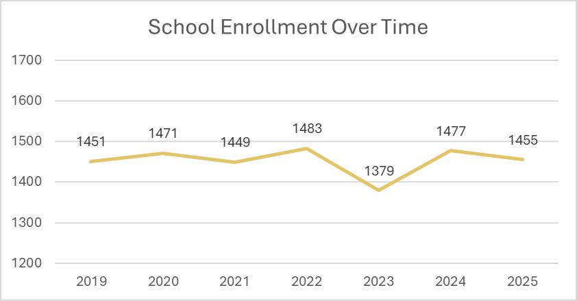
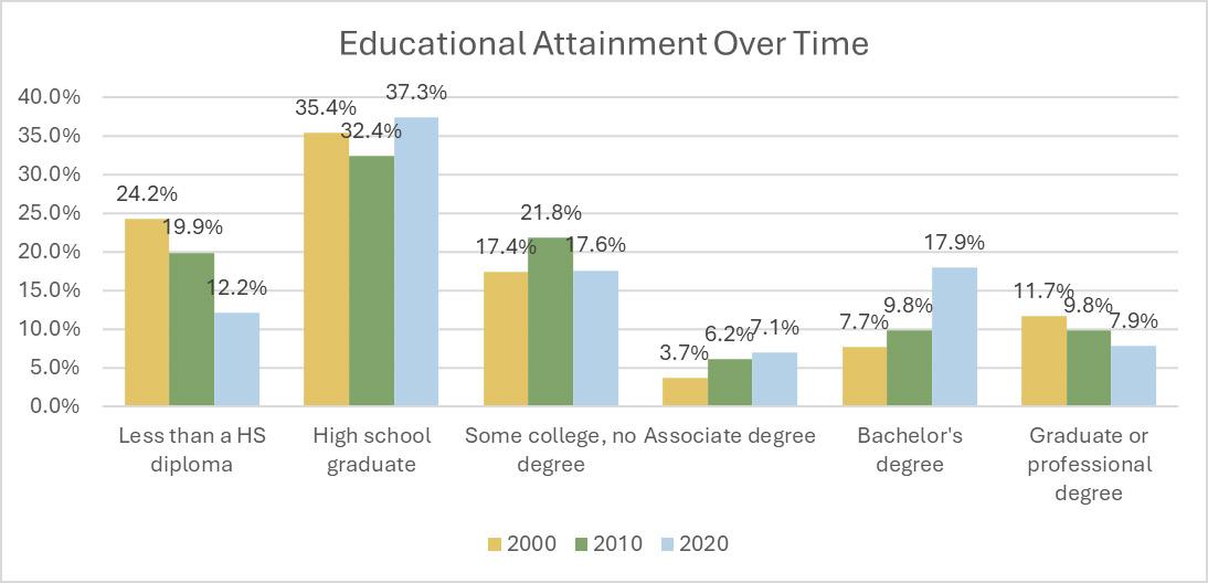
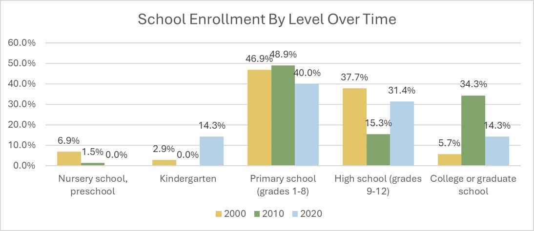
North Posey County Schools report much lower rates of chronic absenteeism compared to the state of Indiana. North Posey Schools reported an 8.5 percent chronic absenteeism compared to Indiana’s 17.8 percent chronic absenteeism. Students in North Posey are only half as likely to be chronically absent as they are statewide. Causes of chronic absenteeism are generally related to transportation, children needing to work or care for others, or lack of access to food and clean clothing. Many of these issues are more prevalent in larger cities.
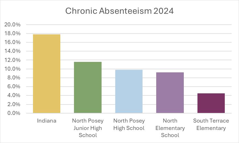
Source: Indiana Department of Education 2013-2024 Chronic Absenteeism Rates
Attendance is high in the school district at an average of 95.75 percent. The state average is slightly lower at 93.22 percent.
With vouchers, school choice, and homeschooling, the State of Indiana tracks students who transfer into districts from other districts, private school, or homeschool situations as well as those who transfer out. Incoming and outgoing student transfers have stayed mainly consistent over the past four semesters. There was a slight increase in both incoming and outgoing transfers during the Fall 2024-2025 semester but a lower number of net transfers that semester. Incoming transfers are consistently notably higher than outgoing transfers, meaning the school system is desirable compared to other options.

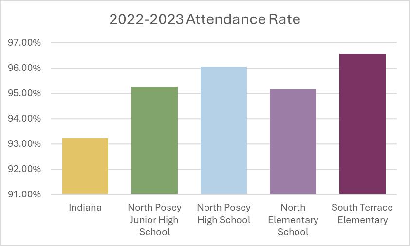
Households
In 2020 there were 334 households in New Harmony. The average household size was 1.95, or fewer than two people per household. Most households (approximately 53 percent) have no children under age 18 living at home, and 165 households have a person over age 65 in the household. Married couples are more than half of households, with single female heads of households representing one-third of households. The household types reinforce the age and gender data for the New Harmony community.
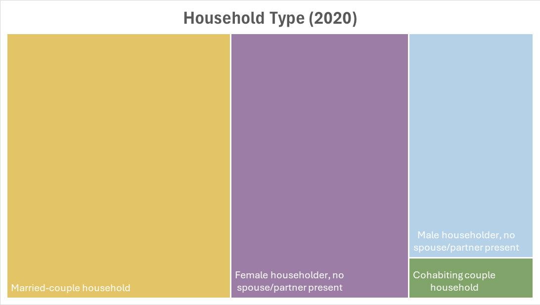
Source: 2020 Decennial Census (DP1)
HOUSING
HOUSING UNITS
As of the 2020 Decennial Census there were 404 housing units in New Harmony. Of these 334 were occupied and 70 were vacant. The vacancy status was approximately one-third in transaction (for sale or rent or sold/rented but not occupied), one-third for seasonal use, and one-third vacant for other reasons – or roughly 24 units in each category. Homeowner vacancy was very low, under one percent so there were few homes available for purchase. Renter vacancy was 11.5 percent, meaning it was fairly easy to find a rental unit. A healthy overall vacancy rate is around six percent to allow people to have housing choice.
OCCUPANCY CHARACTERISTICS
More than three-quarters of the occupied housing units were owner occupied. Owner-occupied units were primarily one or two person households, accounting for approximately 60 percent of these units. There were few large households in New Harmony with five or more people. Half of all renter-occupied units were occupied by a single person. Nearly three-quarters of renteroccupied units were occupied by one or two people. There were larger households in rental housing in the community, with nearly 10 rental units having five or more people.
The largest homeowner age brackets were 65 to 74 years old (more than 80 households) and 75 to 84 years old (nearly 45 households). Renter age brackets were more distributed with a dozen households each in the three age brackets spanning 25 to 54 years old and a dozen each spanning the two age brackets from 60 to 74 years old.
Source: 2020 Decennial Census
Source: 2020 Decennial Census
FINANCIAL CHARACTERISTICS
The median home value in New Harmony was $120,000 in 2020, up from $71,500 in 2000. Inflation alone would account for 2020 home median value of $107,800, rather than the actual $120,000, so there was some real growth in the value of homes between 2000 and 2020.
The median gross rent in New Harmony for 2020 was $802 per month, up from $445 in 2000. Most of the increase in rents occurred between 2000 and 2010, with rents increasing by $238 during the 2000s and only $74 in the 2010s.
The past few years have seen rapid rises in housing costs in most places, with rent increasing more than homeownership costs.
WORKFORCE AND ECONOMY
This section explores the major employers, employment by industry, and commuting patterns for New Harmony.
MAJOR EMPLOYERS
According to the Evansville Region Economic Partnership, there are 14 companies that employ over a thousand people in the region that includes Gibson, Posey, Warrick, and Vanderburgh Counties. Most of the major employers are regional, not local to New Harmony or Posey C`ounty. There are no employers significant to the region that are based in New Harmony. Most of the jobs in Evansville are within an hour drive from New Harmony.
Source: Evansville Regional Economic Partnership
EMPLOYMENT BY INDUSTRY
There are 261 jobs in New Harmony. The largest employment sectors in New Harmony are Accommodations and Food Service (36 percent) and Health Care and Social Assistance (34 percent). Retail trade is the third largest sector at 12 percent. Approximately onethird of workers in New Harmony are over age 55 and the workforce is largely female (67 percent).
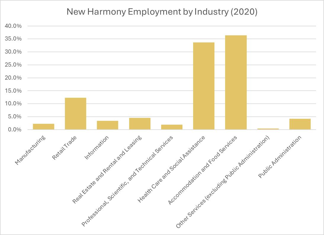
Source: On the Map (Census)
People who live in New Harmony primarily have jobs somewhere else. There are 324 people who live in New Harmony and work, half of them are age 30 to 54. People who live in New Harmony generally have higher incomes than those who work in New Harmony. Approximately 45 percent of people who live in New Harmony and work earn more than $40,000 per year while 17 percent of people who work in New Harmony have that level of earnings.
New Harmony residents work in a wider variety of economic sectors. The top five sectors are Manufacturing (22 percent); Health Care and Social Assistance (13 percent); Retail Trade (11 percent); Accommodation and Food Services (10 percent); and Construction (7 percent).
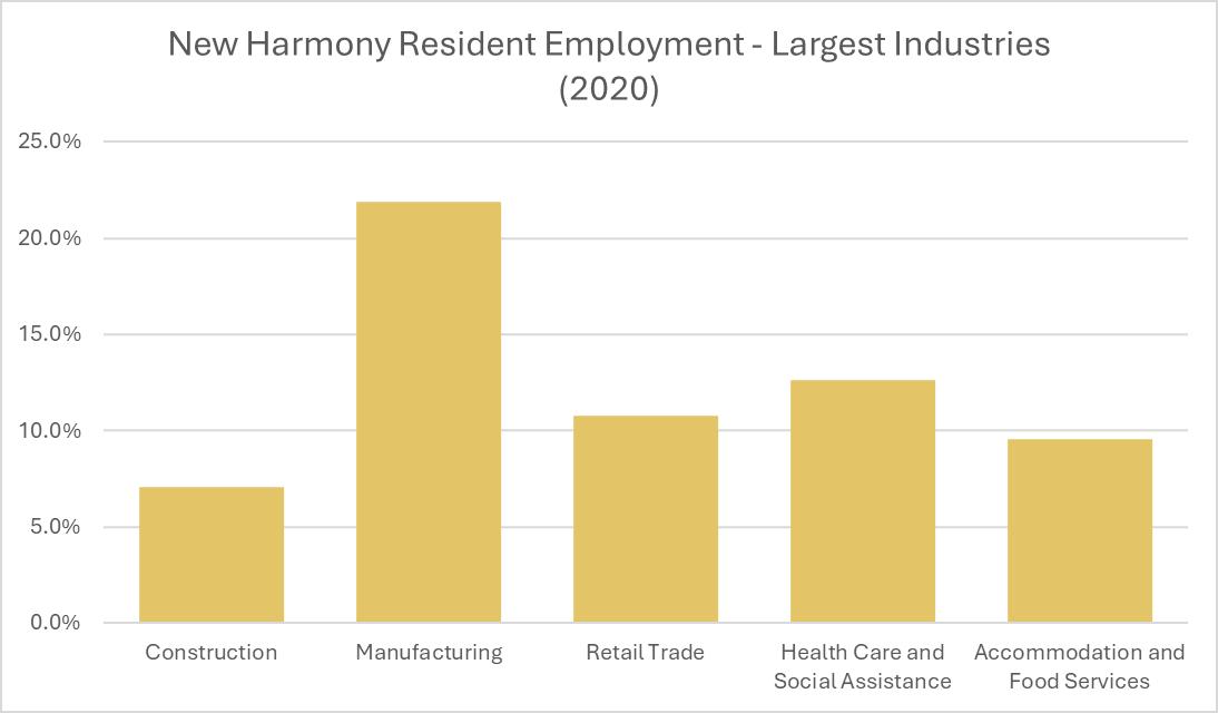
Source: On the Map (Census)
COMMUTING PATTERNS AND MEANS OF TRANSPORTATION TO WORK
Most employees in New Harmony commute to work by car, truck, or van, and drive alone. There is an average commute time of 22 minutes and 41.4 percent of people work outside Posey County. Most residents drive to work, with a few walking or using a bicycle, golf cart, motorcycle, or other means of transportation.

According to Census data from 2000, only 25 people both live and work in New Harmony. Most people work in places that are not identified by the Census (148) but a number of people work in Evansville (79) and Mount Vernon (32). There is a difference of fewer than 100 people that come into New Harmony to work and those who leave New Harmony to work. Due to skills, education, type of work, and income expectations there is not a significant change in commuting patterns anticipated without location of a significant new employer (or several) in New Harmony or the region.

Source: On The Map (US Census)
NOTE: Overlay Arrows do no indicate actual direction of worker flow between home and employment locations.
Employed and Live in Selection Area
Employed in Selection Area, Live Outside
Live in Selection Area, Employed Outside
01 October 2025 Replace Future Land Use Map to correct Heritage Area Preservation Overlay
02 October 2025 Add infrastructure plan to Utilities implementation matrix
