

SF Bay Trail Risk Assessment and Adaptation Prioritization Plan
CONCLUSION:
Across the region and beyond, the effects of climate change – including sea level rise – need innovative, thoughtful approaches to be developed and tested. This series of project case studies aims to serve as a blueprint for similar areas that face similar effects on public resources, natural habitats and ecology. The planning and design processes are built upon input from a broad cross-section of
the community and stakeholders, reflecting a wide spectrum of perspectives which have informed the direction of the solutions, and collaboration across of multiple agencies, local civic leadership knowledge, and skillsets to ensure that projects benefit from and are in alignment with existing efforts along the regional shoreline.
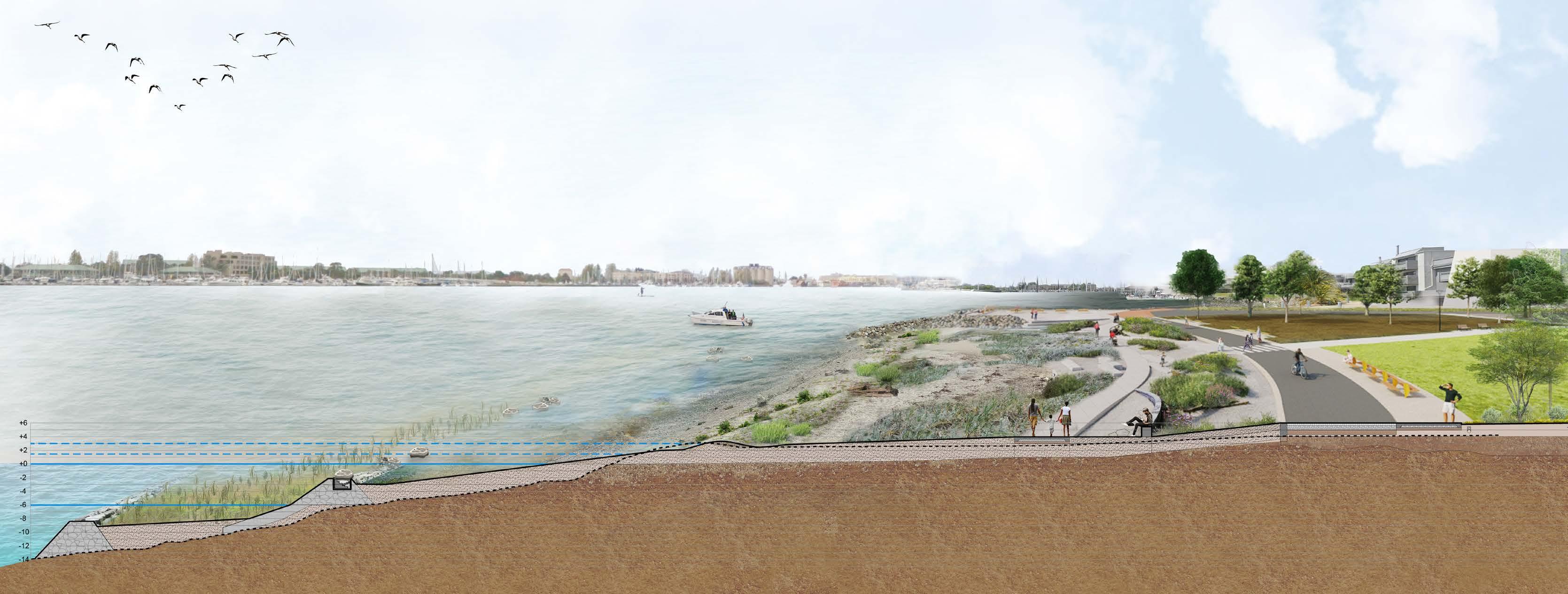
8’ Rock Toe MLLW MHW 2070 MHHW 2100 MHHW 20’-25’ Sloping Eelgrass Bed 15’ ROCKY SUBSTRATE/ OYSTER HABITAT 5’ BEACH TOE 40’ BEACH FACE Existing Grade 10’-15’ ACTIVE BEACH BERM 30’-40’ WASHOVER FAN 12’ SEATING POCKET VARIES BACKSHORE PLANTING, TERRESTRIAL MOUNDS 20’ ASPHALT EVA AND BAY TRAIL 6’-6’’ SEATING ZONE MULTI-USE LAWN 6’ CONCRETE PATH
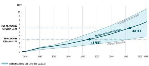
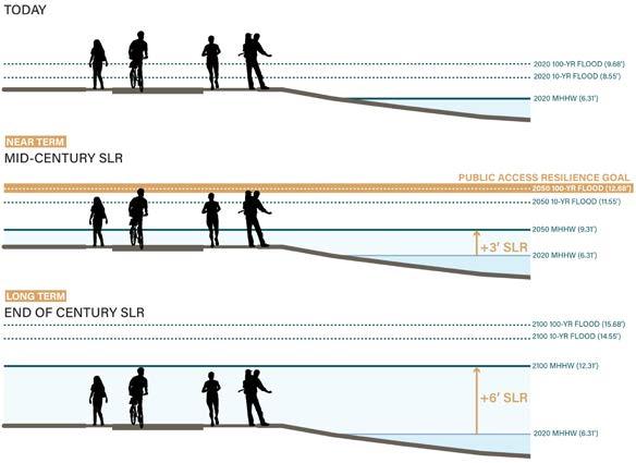
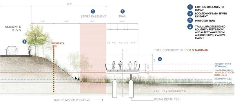
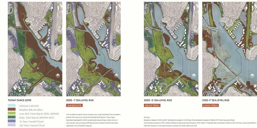
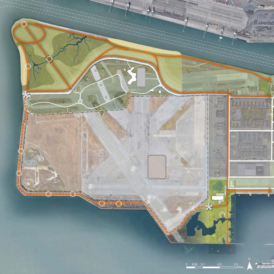
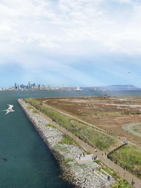
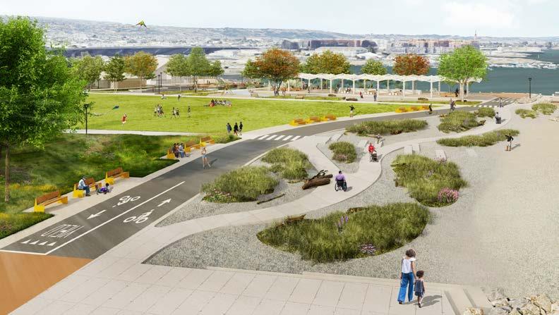
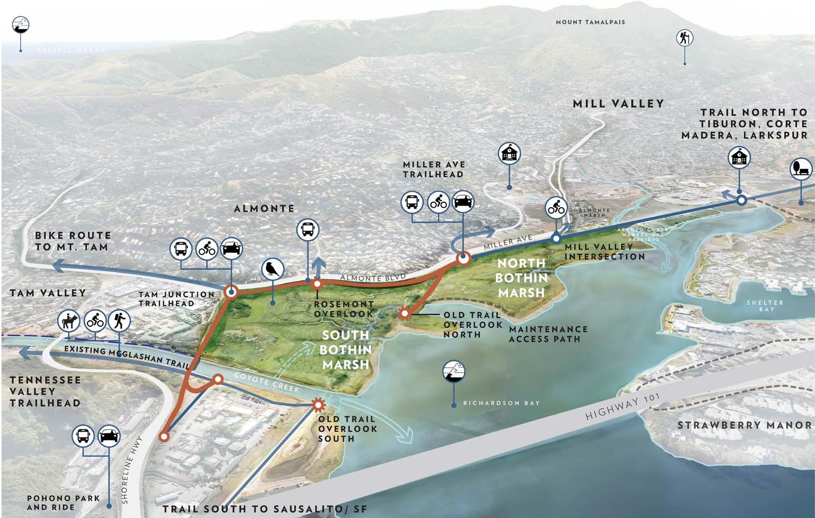
REGIONAL PARK: NORTHWEST TERRITORIES VETERANS AFFAIRS: CLINIC & COLUMBARIUM CITY OF ALAMEDA: REGIONAL SPORTS COMPLEX CITY OF ALAMEDA: ADAPTIVE REUSE AREA CITY OF ALAMEDA: WATERFRONT PARK CITY OF ALAMEDA: DE-PAVE PARK VETERANS AFFAIRS: LEAST TERN PRESERVATION AREA (ACCESS RESTRICTED) SOUTHWEST SEASONAL BAY TRAIL LEAST TERN COLONY The Northwest Territories will be regional park that supports a range of ecological diversity and provides year-round public access to the shoreline. The regional sports complex will be multi-use facility for Alameda residents. The adaptive reuse area will create a compact, transit oriented, mixed-use urban core that will leverage the unique character and existing assets of the area. De-Pave Park will transform the paved tarmac into a thriving ecological park that adapts to sea level rise inundating over time to create tidal wetlands and wildlife habitat. The VA Clinic & Columbarium will provide greater range of veteran services to the Bay Area. WHY IS THE SOUTHWEST BAY TRAIL SEASONAL? Alameda Point is home to colony of Least Terns, an endangered species whose nesting season lasts from April to August. The seasonal trail offers an opportunity to learn about the special species during non-nesting season. The Bothin Marsh Open Space Preserve is simultaneously Marin County Parks’ most visited and most vulnerable open space. It currently floods more than 30 times a year with projections estimating 220 flood days per year with one foot of sea level rise. Once completed, the high-volume public trail will be fully accessible year-round, while providing the space for the marsh to evolve in the coming years to support the abundant wildlife and plant species that call the marsh home. The project is strong example of the importance of procedural equity in the planning and design process. Through the One Tam partnership (including the Golden Gate National Parks Conservancy and Marin County Parks), the project has led both community-wide educational engagement activities focused on climate adaptation, and participated in Countywide agency conversations related to sea level rise preparation. The Estuary Park Renovation + Expansion project presents an opportunity to significantly improve a treasured waterfront space in the city of Oakland. is located on the Oakland Estuary at the mouth of the Lake Merritt Channel and surrounded by a rapidly developing new residential district adjacent to Jack London Square. Developed between 1969 and 1972 based on plans by Lawrence Halprin, the park has fallen into disrepair in recent years. Through additional funding, the resources for complete renovation of the park and its expansion from 7 acres to 11 acres have been acquired. As the project moves forward and incorporates highly-valued resilient shoreline features to accommodate sea level rise, the City of Oakland is proactively securing new grant opportunities to complete the implementation. Championing Messy and Complex Shorelines There are multifaceted challenges across the SF Estuary that come together along our politically messy and complex shorelines. Consensus-building and decision-making as a community have never been more important and the complexity is compounded by forces such as sea level rise, housing crises, recreational access, habitat loss, jurisdictional overlap, historic fill, contamination, and cost. The overview highlights recent projects grappling with these variables to build a clear decision-making process, aiming to break down silos and weave together the intricate interplay between human activities, habitat preservation, and resilience strategies. To convey these complex issues to the community, project teams rely on clear graphics and frameworks to understand the diverse ABSTRACT: tradeoffs and symbiotic interconnectedness inherent in shoreline management. Recognizing the vital functions performed by shorelines, the research explores win-win scenarios and strategies for advancing multi-benefit projects. The poster delves into three examples, including the SF Bay Trail Risk Assessment and Adaptation Prioritization Plan (RAAPP) with the East Bay Regional Park District, Bothin Marsh with ONE TAM (Marin County Parks and the Golden Gate National Parks Conservancy), and Estuary Park with the City of Oakland. The RAAPP covers shoreline decision-making at a large scale. Bothin Marsh illustrates the balancing act required to enhance community resilience while addressing multiple goals, such as retaining sediment, adapting public access, and ensuring habitat Planning horizons illustrate the implications of sea level rise on the elevation of resilient Bay Trail. For the purposes of this study, when applying sea level rise projections to a typical shoreline cross-section, the total water level builds from the existing mean higher-high water level (MHHW) identified at the site and includes sea level rise and 100year storm event levels in combination. Other factors like wave run-up conditions and erosion were considered and included in the risk assessment separately. Projects undergoing design review with BCDC typically provide an adaptation plan that maintains public access resilient to 100-year storm and sea level rise through the year 2050. For the purposes of each study, the “Public Access Resilience Goal” is defined for the mid-century scenario and varies based on the combination of coastal hazards. ADAPTATION APPROACHES:
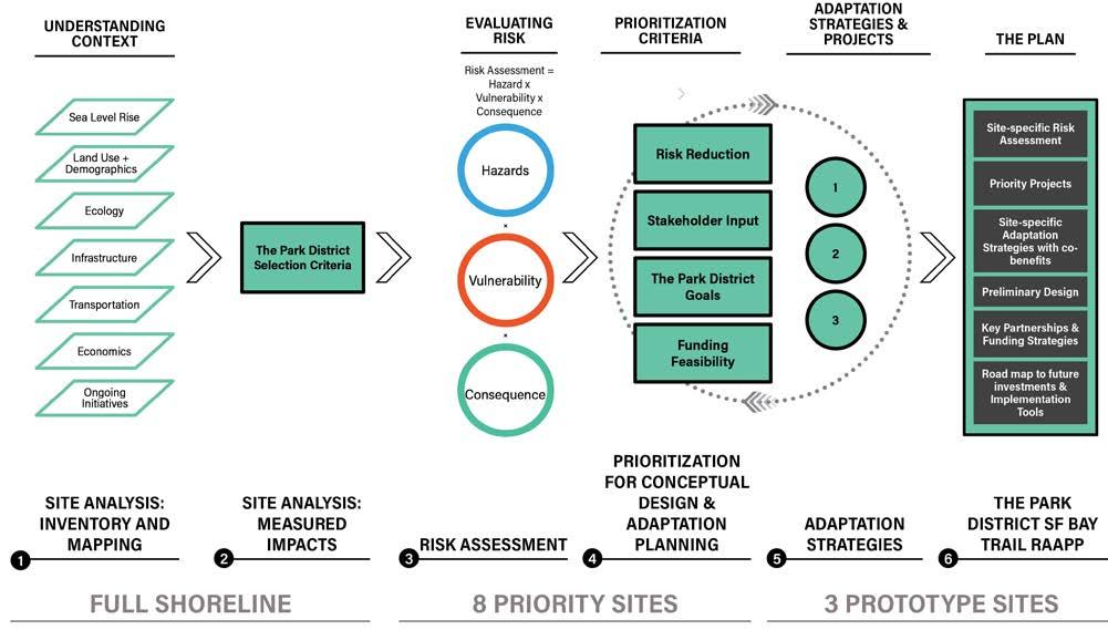
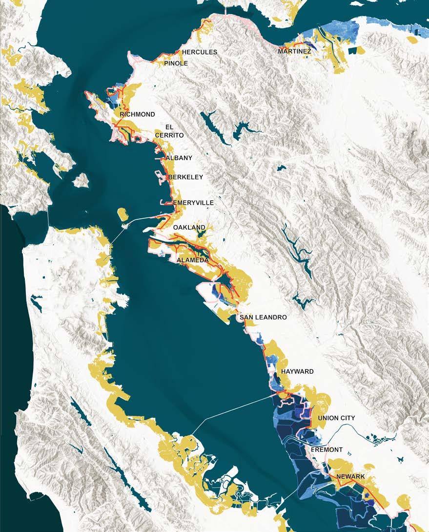
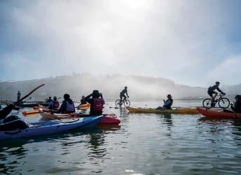
WORK BAY TRAIL VULNERABILITY Source: WRT, LIDAR & SFEI Shoreline Inventory ART CoSMoS PLANNING HORIZONS (2018) Source: Graphic by WRT, based on OPC’s State of California SeaLevel Rise Guidance, 2018. DESIGN GUIDANCE MODEL Source: WRT, based on OPC’s State of California Sea-Level Rise Guidance, 2018. The SF Bay Trail RAAPP approach is structured around process that explores the existing conditions and predicted impacts of climate change and sea level rise across multiple scales. First, by looking across the full East Bay shoreline along both Alameda and Contra Costa counties, identifying the top at-risk zones and developing Risk Assessment; and then by zooming in to exemplar focus areas to illustrate potential adaptation strategies and approaches that could be applied in multiple locations across the region. At each scale, and through the process, the analysis and design are guided by the Park District goals and informed by ongoing conversations with key partners and stakeholders. Alameda Point and more specifically, the Northwest Territory, is at risk in both the midand end-of-century planning scenarios explored in this study. The site is in the process of being planned as new regional park with a Bay Trail extension to be managed by the Park District and is part of a larger master plan coordinating contamination mitigation, and ongoing planning processes with the Park District’s partners, including the City of Alameda, the US Navy, and the US Department of Veterans Affairs (VA). The recommended adaptation approaches vary based on the long-term decisions related to site cleanup, but both examples show the potential for the Bay Trail and the new regional park to adapt through the end-of century. 1. RESILIENCE TO COASTAL HAZARDS 2. RESTORATION POTENTIAL 3. MINIMIZE RECURRING MAINTENANCE 4. ADJACENCY TO CRITICAL INFRASTRUCTURE 5. SERVING DISADVANTAGED COMMUNITIES 6. ACCESS TO NATURE, USER EXPERIENCE 7. FUNDING AND PARTNERSHIP POTENTIAL 8. ALIGNMENT WITH PARK DISTRICT MASTER PLAN GOALS AND PRIORITIES 9. REPRESENTATION OF A DIVERSITY OF COASTAL CONDITIONS AND GEOGRAPHIES HOLD THE LINE Maintains and defends existing shoreline configuration by upgrading flood protection infrastructure and limited use of natural and nature-based adaptation approaches. BUFFER WITH PUBLIC OPEN SPACE Moving the existing first line of shoreline defense landward by creating buffer of public open space where some areas can be temporarily inundated, providing potential additional habitat. Requires minimal reconfiguration of existing vulnerable infrastructure. Use of nature-based adaptation measures as necessary for identified vulnerabilities. MAXIMIZE HABITAT AND REALIGNMENT Realignment of vulnerable shoreline infrastructure as necessary in order to maximize opportunities for nature-based approaches, with an emphasis on restoring/enhancing connectivity of natural processes. HYBRID APPROACH Combines different strategies over time and/or space to balance objectives for infrastructure, open space, and habitat. ALAMEDA POINT: NORTHWEST TERRITORY & ADJACENT PLANNING Source: WRT ANALYSIS ROADMAP Source: Graphic by WRT ALAMEDA POINT: SEASONAL TRAIL Source: WRT ESTUARY PARK RESILIENT SHORELINE PLAN Source: WRT BAY TRAIL & SHORELINE DESIGN ALONG ESTUARY PARK Graphics & landscape architecture by WRT, environmental engineering by ESA PARTNERING TO ADAPT MARSH HABITAT AND PUBLIC ACCESS Cyclist on the Mill Valley-Sausalito Pathway passes kayakers during typical King Tide PREDICTED SEA-LEVEL RISE IMPACTS ON BOTHIN MARSH Source: WRT ELEVATED TRAIL SECTION ALONG ALMONTE BLVD Source: WRT ESTUARY PARK RESILIENT SHORELINE SECTION Graphics & landscape architecture by WRT, environmental engineering by ESA PUBLIC AGENCY LED RESILIENT SHORELINE DESIGN
BUILDING TOWARDS ADAPTATION Cristina Bejarano, AICP, ASLA, Planner + Urban Designer; Peter Trio, Landscape Architect; Can Liu, ASLA, PLA, LEED AP ND, Landscape Architect; Yue Hu Landscape Designer Location: Alameda and Contra Costa County, CA Client: East Bay Regional Park District; Consultant Team: WRT with support from ESA, Arup, OnClimate SUB-TIDAL ZONE INTER-TIDAL ZONE BEACH BERM BACKSHORE TRANSITIONAL BACKSHORE UPLAND PARK longevity. Special attention is given to minimizing the impacts of trails and public access without disrupting crucial habitat and landscape processes. The Estuary Park project is highlighted for its integrated, multi-benefit design solution, incorporating elevated embankments, beaches, and buffering transition zone to enhance aquatic ecology. Concluding insights emphasize team leadership, effective translation of scientific knowledge, and the navigation of diverse agency jurisdictions. Empowering communities, fostering community champions, and ensuring fluency in adaptation concepts emerge as critical components in creating a unified vision, building consensus, and fostering collaboration to advance shoreline management efforts. 1 Estuary Park Renovation + Expansion Location: Oakland, CA Client: City of Oakland; Consultant Team: WRT with support from ESA 2 Bothin Marsh Adaptation Project Location: Marin County, CA Client: One TAM (Golden Gate National Parks Conservancy & Marin County Parks); Consultant Team: WRT & ESA 3 PROPOSED TRAIL & MARSH ADAPTATION Source: WRT BAY TRAIL ADAPTATION PLANNING GOALS:
CONSENSUS