42 l Glaciers of the Himalayas
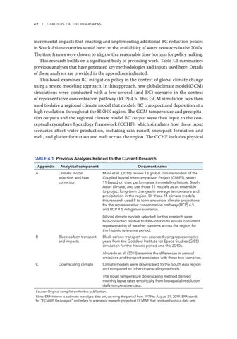
incremental impacts that enacting and implementing additional BC reduction polices in South Asian countries would have on the availability of water resources in the 2040s. The time frames were chosen to align with a reasonable time horizon for policy making. This research builds on a significant body of preceding work. Table 4.1 summarizes previous analyses that have generated key methodologies and inputs used here. Details of these analyses are provided in the appendixes indicated. This book examines BC mitigation policy in the context of global climate change using a nested modeling approach. In this approach, new global climate model (GCM) simulations were conducted with a low-aerosol (and BC) scenario in the context of representative concentration pathway (RCP) 4.5. This GCM simulation was then used to drive a regional climate model that models BC transport and deposition at a high resolution throughout the HKHK region. The GCM temperature and precipitation outputs and the regional climate model BC output were then input to the conceptual cryosphere hydrology framework (CCHF), which simulates how these input scenarios affect water production, including rain runoff, snowpack formation and melt, and glacier formation and melt across the region. The CCHF includes physical
TABLE 4.1 Previous Analyses Related to the Current Research Appendix A
Analytical component Climate model selection and bias correction
Document name Mani et al. (2018) review 18 global climate models of the Coupled Model Intercomparison Project (CMIP5), select 11 based on their performance in modeling historic South Asian climate, and use those 11 models as an ensemble to project long-term changes in average temperature and precipitation in the region. Of these 11 climate models, this research used 8 to form ensemble climate projections for the representative concentration pathway (RCP) 4.5 and RCP 4.5 mitigation scenarios. Global climate models selected for this research were bias-corrected relative to ERA-Interim to ensure consistent representation of weather patterns across the region for the historic reference period.
B
Black carbon transport and impacts
Black carbon transport was assessed using representative years from the Goddard Institute for Space Studies (GISS) simulation for the historic period and the 2040s. Alvarado et al. (2018) examine the differences in aerosol emissions and transport associated with these two scenarios.
C
Downscaling climate
Climate models were downscaled to the South Asia region and compared to other downscaling methods. The novel temperature downscaling method derived monthly lapse rates empirically from low-spatial-resolution daily temperature data.
Source: Original compilation for this publication. Note: ERA-Interim is a climate reanalysis data set, covering the period from 1979 to August 31, 2019. ERA stands for “ECMWF Re-Analysis” and refers to a series of research projects at ECMWF that produced various data sets.


