
Devon and Cornwall Soils Alliance Knowl Water – Business Case


Phil Metcalfe & Sophia Craddock
December 2021
© Copyright Roger A Smith (CC BY-SA 2.0)1 Introduction
The following report provides a brief business case overview of the findings from the feasibility study area, which is one of nine across the Devon and Cornwall region funded by the Water Environment Grant (WEG). These waterbodies fail the WFD for sediment related issues and these business cases provide evidence as to type and location of soil and sediment issues, degree of farm advice and grant required to support business, regulatory issues/failings and whether current farming practices within the catchment are aligned with inherent land capability.
2 Knowl Water
2.1 Background
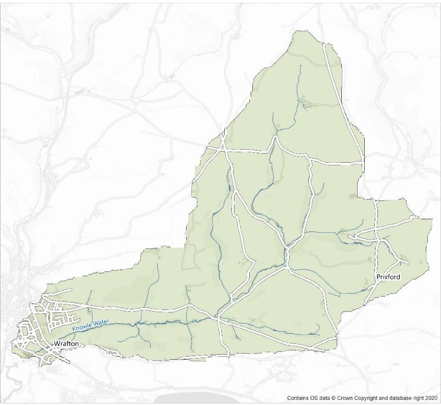
The Knowl Water catchment is situated in North Devon, it feeds into the Taw-Torridge estuary and is approximately 1180ha (Figure 1). The catchment has a high presence of rotational arable field management, and a number of issues were observed during wet-weather walkover surveys, including, soil compaction, run-off, poaching and erosion.
2.2 Deskbased study
The maps provided by the Westcountry Rivers Trust (WRT) in the map pack were generally accurate and provided a good reflection of the catchment.
The data presented in the map pack provided by WRT were generally accurate The study team have surveyed this catchment several times over the last four years and had sufficient reconnaissance data to understand where water quality pressure would occur. There are a plethora of issues that have gone unresolved and a number of landowners replete with repetitive issues that have sadly dismissed advice and support. Known problematic areas
where categorised as key targets prior to undertaking site walkovers. When priority sites visits were complete a broad catchment survey was planned.
2.3 Literature summary
A search for literature on the catchment returned nothing of relevance. Previous project work undertaken by the Environment Agency and North Devon Biosphere through the North Devon Focus Area Project and Wrafton NFM study provided adequate baseline information on the catchment.
2.4 Fieldwork findings
Much of this arable area is currently under short term rye grass leys with some sporadic postharvest maize areas, arable stubbles, and fodder crop remnants. Many fields are sitting wet and are generating soil mobilisation and runoff issues during rainfall events. Poor drainage across soils in the catchment is a consequence of poaching and compaction caused by mistimed/inappropriate agricultural activities. Land use is dominated by arable cropping/rotations and permanent grassland pastures in approximate equal measures. There are limited wooded areas, mostly confined to the steepest valleys or combes. Dominant soil problems identified through this study are poaching, capping and soil movement/loss from parcels through mistimed agricultural activity, high risk cropping, poor management of vehicular access and overstocking onwet soils. The core soil issues observed are directly linked to arable systems, grazed fodder crops and outwintered stock. As a high proportion of the current arable area is under rye grass leys, the full scale of arable management risks were not present to be documented as they have been in previous years and will be in years to come.
Soil compaction and surface runoff is widespread throughout the Knowl Water, however it is several holdings that are responsible for a high proportion of the soil health issues identified, but these were distributed evenly across the catchment.
2.5 Regulation
The Soil Mentor was asked a series of questions that related to the issues and failings they observed in the catchment. These questions and the Soil Mentor’s responses are outlined in (Table 1). In the Knowl Water catchment it was estimated that between 51-75% of the highlighted issues were classed as regulatory failings, which is similar to the majority of the catchments surveyed.
Of the issues highlighted in the feasibility report, what percentage of these issues would be classed as regulatory failings? E.g. SSAFO, FRFW, X compliance. Please note, this is for the % of issues highlighted, not the % of the whole catchment?
Would better enforcement of current regulations such as FRFW, X-compliance, NVZ work towards improving the issues highlighted?
2.6 Land capability and landuse type
The observations of the Soil Mentor in the Knowl Water catchment suggest that there are areas where the farming practices are not aligned to the capability of the land. With all observations of soil mobilisation, surface runoff and pollution threats arising from poor soil management and unsuitable stocking practices.
2.7 Solutions and recommendations
The Soil Mentor thought that all the issues observed in the catchment could be improved by better enforcement of current regulations and suggested that multiple approaches were needed, including:
- Farm advisors to identify issues and educate land-owners;
- A wholesale change of farming practice, including a complete revision of the farm business/ethos;
- Holdings that contribute relatively less frequent/severe impacts, they may be resolved through conventional existing/future agri-environment programmes.
3 Estimated cost of remediation
The approximate costs of addressing the pollution issues in the catchment are shown in Table 2.
Recommendation
Estimated cost
Watercourse fencing -2,104m + 5 gates £20,000
Riparian and catchment/cross slope woodland creation – 4.55ha £41,000
Wetland creation - 6,980m2 £70,000
Infill and relocate gateway - 5 £500
Soil decompaction/aeration – 55ha £1,000
Reversion to grass/herbal lay – 55ha £17,000
Track diverter – 5 £500
10 holdings to engage, approximately 2 - 3 year timeframe £162,000
Total cost £312k (medium)
3.1 Risks and barriers associated with solutions
The risks associated with the approaches outlined above identified by the Soil Mentor included: - Landowner engagement; - Upcoming changes to the income support system.
3.2 Benefits of change
The benefits brought about by the recommendations of this study could potentially lift water quality standards in the catchment in line with WFD requirements. The confidence ascribed to this assertion is based on a knowledge of where the greatest pressures on water quality arise in the catchment. By ameliorating the risks of several landowners and features in the area the study team believe that the largest contributions of sediments and pollutants will be eliminated. Sediment burdens from targeted land holdings under arable rotations would be dramatically reduced and soils will remain within parcels and holdings rather than be washed into the local river network and out to sea.
Land managers entering into woodland creation agreements may be eligible to apply for some form of carbon payment. Current offers are based on creating >5 ha of new woodland but there may be changes to this threshold in the coming years.
If natural capital accounts are integrated into business plans for land holdings entering into ELMS agreements some of the natural solutions advised in the report including woodland and wetland creation could be eligible for future area-based payments.
3.3 Lessons learnt
The study period operated through the Covid-19 Pandemic and therefore had a baring on several activities including, but not limited to:
- Restrictions to meeting with receptive landowners
- Restrictions to undertaking site walkovers with receptive landowners
- Restrictions to undertaking site investigations through soil pit analysis
Beyond the limiting factors of Covid-19, the study team were unable to survey the full length of watercourses in the catchment due to access restrictions and this has had an impact on our complete understanding of soil/sediment burdens on the water network.
Maptionnaire was a useful tool for quickly mapping out survey findings and drawing interventions. Its main limitations are that once a session has been saved and closed the user can no longer see or revisit/edit what they have previously entered. This is an unhelpful aspect of the programming as it renders the user unable to retrace or refine previous entries. We were advised that the new system would include the option to go back and review previously submitted data but this feature never materialised.
The timeframe and time period of the project alsohad an impact on the outcome of this report. The relatively short timescale, incorporating the Christmas holidays, reduced the opportunity to capitalise on some of most persistent and heavy rain events that occurred over the winter period potentially limiting the successfulness of identifying all areas with soil mobilisation and surface runoff issues.
Positive aspects of the study were the informative and challenging discussions that were held during the workshops and gaining a perspective of issues in other catchments and how co advisors sought best to resolve them. Communication from the project team and one to one discussions have been very helpful.