

Plaza de Armas and the Cathedral
The central fountain from 1845 stands out in the Plaza de Armas (main square). To carve it, the Italian architect Julio Seretti used a large granite stone (pacarina) that was the object of worship for the ancient inhabitants of the area. The cathedral exhibits canvases from the Cusco school and a carving of the Señor de Burgos, king and patron of Huánuco, the work of Jerónimo Scorcetto, declared a Cultural Heritage of the Nation. Its silver chandeliers of almost 2 meters high are a great attraction.
Museo Regional Leoncio Prado
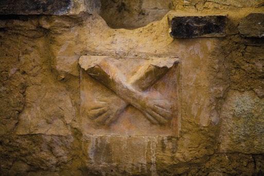
Jr. Dos de Mayo 680. Mon-Fri, 9:00-13:00. Entrance fee charged. The regional museum is named after Leoncio Prado, hero of the battle of Huamachuco. It preserves the archaeological, historical, artistic, and ethnographic heritage of Huánuco. The replica of the crossed hands of Kotosh, the halls of Archaeology and Natural History, and the room of photographs and testimonies of the national hero’s life are of great interest for visitors.
Churches
The colonial architecture of this city is best appreciated through its churches (visits during mass or prior coordination with their parish secretariats). San Francisco (Jr. Damaso Beraún 391) is a neoclassical style church, its altars are covered with gold leaf, of colonial and mestizo baroque style. San Sebastián (Jr. Dos de Mayo, cdra. 3) and La Merced (Jr. Hermilio Valdizán, cdra. 4) are also noteworthy.
Puente Calicanto
984 ft (300 m) from the Plaza de Armas of Huánuco (5 min walk)
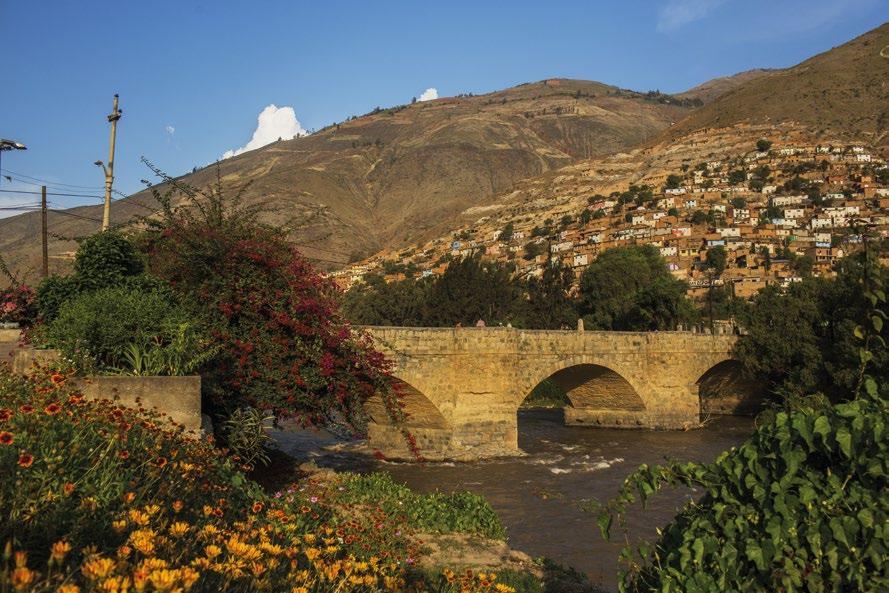
The masonry bridge was built on the Huallaga river between 1879 and 1884. It has three arches and two central abutments and is 60 meters long. On the sides of the road, on the central jetties, there are four viewpoints with stone benches for rest. Made of granite, the bridge connects the districts of Huánuco and Amarilis.
Sala de Exhibición de Historia y Arte Religioso Churubamba
Jr. Javier Lindo Zárate 110, Churubamba, 21 km north of the city of Huánuco (30 min by car). Mon-Sun, 8:00-16:00. Entrance fee charged.
The museum of history and religious art exhibits a collection of mummies found in the archaeological complex of Papahuasi, as well as lithic and ceramic pieces.
Zona arqueológica monumental de Kotosh
3 miles (5 km) west of the city of Huánuco (15 min by car or mototaxi). Mon-Sun, 9:00-16:30. Entrance fee charged.
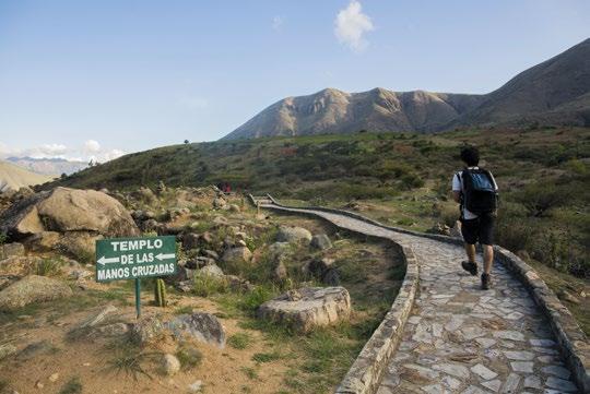
Three temples form Kotosh archaeological complex dating back to 2000 BC — Nichitos, Blanco and Manos Cruzadas. The latter is named after two sculptures that adorn its larger niche and represent duality. Kotosh is the earliest evidence of public and ceremonial architecture in the Andes. It has a magnetic point that amplifies the visitor’s voice in front of others equidistant from him.
Casa Hacienda Shismay
11 miles (17 km) east of the city of Huánuco (45 min), HuánucoLa Esperanza-Shismay route. Visits after prior coordination. Entrance fee charged. The hacienda was built by German settlers in 1857. It stands on a stone platform supported by 12 stone buttresses standing 26 ft (8 m) high. On the façade, an arched corridor stands out, leading to a colonial altar chapel consecrated to the Virgen de las Mercedes and San Sebastián, patrons of the ranch. Declared a historical monument, it is currently a site museum. It also offers accommodation and a cuisine with an identity based on fresh products from its gardens.
Área de Conservación Regional Bosque Montano de Cárpish
25 miles (40 km) northeast of the city of Huánuco, towards Tingo María (1 h by car). Mon-Sun, 8:00-16:00.
The Cárpish mist forest marks the passage from the mountains to the jungle. It is the ideal place to appreciate the wide variety of flora and fauna of the high jungle.
In 2020, the Área de Conservación Regional Bosque Montano de Cárpish was created to preserve a representative sample of the Peruvian yungas and wet punas of the central Andes, and the biodiversity of the Carpish mountain range.
Jatun Uchco
15 miles (24 km) south of the city of Huánuco (40 min by car) by paved road, then a 20-minute walk (0.3 miles / 500 m). Mon-Sun, 9:00-15:00.
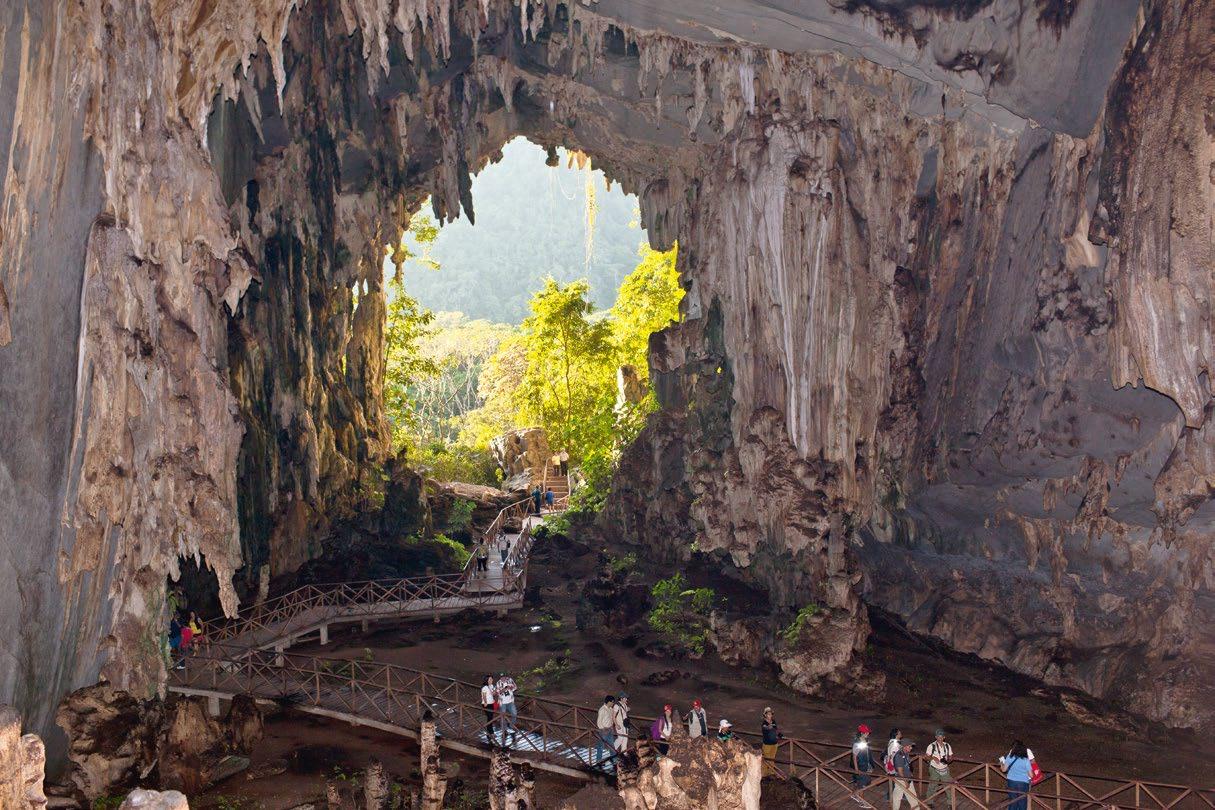
Jatun Uchco, “large hole” in Quechua, is a mysterious cave located 2,570 m south of Ambo Plaza de Armas. The remains of a saber-toothed tiger were found in the cave, and they are currently exhibited in the town hall. Also, from the entrance of the cave, the panoramic view of the city and the valley of the Huallaga river is simply delightful.

Tomay Kichwa / Casa de “La Perricholi”
Tomay Kichwa, 12 miles (19 km) south of the city of Huánuco and four blocks away from the Plaza de Armas (30 min by car and 5 min on foot) Mon-Sun, 8:00-18:00. Entrance fee charged. It is the hometown of Micaela Villegas, “La Perricholi,” lover of Viceroy Amat y Junyent in the eighteenth century. Walking by its narrow streets you can appreciate the traditional houses with large courtyards, and the beautiful landscapes. The house, built in adobe in 1739, preserves furniture from those times. Due to its location on a steep slope, the panoramic view of the village of Tomay Kichwa is amazing.
Lagunas Pichgacocha
22 miles (35.4 km) southeast of the city of Huánuco, on the Huánuco-Conchamarca-Yaurin-Pichgacocha route (1 h by car and 15 min on foot) There are five lagoons, at an elevation of 11,155 - 13,123 ft (3,700 - 4,000 m), connected through streams and waterfalls. In their water mirrors you can take boat trips and practice sport fishing.
Complejo arqueológico Atash

30 miles (48 km) by dirt and paved road. Route: Huánuco-Ambo-Huácar (1 h and 30 min by car). Mon-Sun, 8:00-16:00. Entrance fee charged. Atash archeological complex has two areas clearly differentiated — the residential core and the surrounding agricultural area, made up of thousands of platforms and dozens of terraces. This pre-inca archaeological site (13th-15th centuries) has an extension of approx. 10 to 15 hectares.
Fundo Cachigaga
10 miles (16 km) south of the city of Huánuco (25 min by car) Route: Huánuco-Las Pampas-Cachigaga. Mon-Sun, 9:00-17:00. The landed property has sugarcane plantations, used as raw material for the production of aguardiente, and a mill where sugarcane brandy, rum, guarapo, anise, chancaca, panela, cane honey and vinegar are currently produced.
Zona Arqueológica Monumental Garu
47 miles (75 km) northwest of the city of Huánuco on the Huánuco-Choras-Garu (2 h and 30 min by car) route. Mon-Sun, 8:30-17:00. Entrance fee charged. The housing, administrative, religious and defense constructions within the archeological area of Garu indicate that the site might have been the political-administrative headquarters of the Yaros. It was one of the most organized and populated complexes in ancient Peru. From the Lacshahuarina hill (“crown of the Inca”) you can contemplate a panoramic view of the mountain range.

Cordillera Huayhuash: Nevado Yerupajá
Route 1: 72 miles (166 km) southwest of Huánuco (4 h by car and 3 h on foot).
Route Huánuco-Jesús-Baños-Queropalca-Carhuacocha lagoon-Huayhuash mountain range. / Route 2: 63 miles (101.7 km) southwest of La Unión (4 h by car and 3 h on foot). La Unión-Baños-Queropalca-Carhuacocha lagoon-Huayhuash mountain range. Visits from May to September. Entrance fee charged. It is preferable to use a travel agent.
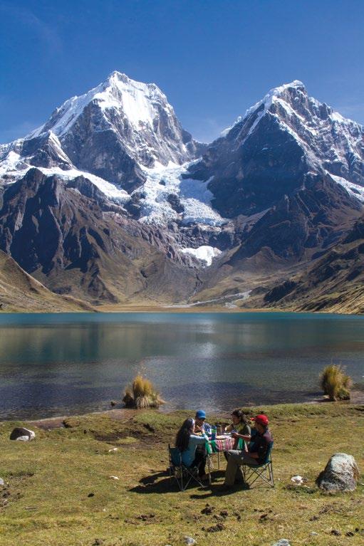
The 9-day trek begins in Queropalca. Huayhuash is a mountain range of 19 miles (30 km) long, located on the border of Huánuco, Lima and Áncash, and it is ideal to go climbing. Its highest and most challenging snow-capped mountains are the Yerupajá (21,765 ft / 6,634 m), the Siula (20,814 ft / 6,344 m), the Sarapo (20,102 ft / 6,127 m) and the Rondoy (19,288 ft / 5,879 m).
Yerupajá is the second highest snow-capped mountain in Peru and a real challenge for climbers due to the steep slope of its ice walls. The lower limit of the snow is at approx. 14,108 ft (4,300 m) high and it occupies an area of 0.8 sq. miles (2.1 km2).
Laguna Carhuacocha
96 miles (155 km) southwest of Huánuco (4 h by car and 3 h on foot via Queropalca). Route: Huánuco-Jesús-Baños-Queropalca-Carhuacocha lagoon. Open from May to September. Entrance fee charged.
The Carhuacocha lagoon is located at the foot of the Yerupajá mountain and it has a beautiful landscape. It is one of the most beautiful lagoons on the trekking route in the Huayhuash mountain range, with a mirror of turquoise water. You can practice sport fishing and boating, and you can camp nearby. There are various animals to watch, such as tarucas, vizcachas, foxes, skunks, and various species of birds (ducks, huachas, puffins, and hawks).
Laguna de Lauricocha
75 miles (120 km) southwest of the city of Huánuco on the Huánuco-Jesús-Cauri-Lauricocha route (4 h and 30 min by car). Mon-Sun, 8:00-18:00.
The Lauricocha lagoon is located at the foot of the Raura mountain range, at an elevation of 13,123 ft (4,000 m). Totora reeds grow on its shores, and trout are the most common fish in its waters. Here you can find tarucas, vizcachas, foxes and skunks, as well as various species of birds such as ducks, huachas, cranes, puffins, partridges, bandurrias, goldfinches and hawks. Nearby, in the Lauricocha cave, the remains of the oldest man in America (10,000 BC) were found.
Aguas termales de Baños
69 miles (111 km) southwest of the city of Huánuco on the Huánuco-Jesus-Baños route (3 h and 30 min by car). Mon-Sun, 8:00-17:00. Entrance fee charged.
In the bathhouse of the Inca there are two wells with channels for hot and cold water where the Inca used to bathe.
Bosque Montepotrero
Umari District, Pachitea Province. 34 miles (55 km) from the city of Huánuco, along the Huánuco-Tambillo-Piñaurco route, and about 2,000 ft (600 m) on foot (2 h by car and 20 min by rural road). Mon-Sun, 8:00-17:00. Entrance fee charged. Montepotrero forest is a beautiful and peaceful place, and it forms part of the chain of mist forests that, due to its ecogeographic characteristics, is home to a biodiversity of flora and fauna. It is the ideal place for watching birds, orchids, and native fauna, as well as for practicing eco-adventure.

Zona arqueológica monumental Huánuco Pampa
93 miles (149 km) west of the city of Huánuco (4 h 30 min by car) Mon-Sun, 8:30-16:30. Entrance fee charged.
The construction of this Inca administrative center began in 1460 and stopped in 1539 due to the Spanish conquest. The buildings in the archeological site include the Inca Wasi, the bathhouse of the Inca, the three-door palace, the unfinished temple and the Ushno where the Inca celebrated the Inti Raymi (unique in all of Peru). The representation of the Inti Raymi (Festivity of the Sun) takes place every July 27.
Hot springs
Conoc: 1.9 miles (3 km) north of La Unión (10 min by car)
Tauripampa: 1.9 miles (3 km) south of La Union (10 min by car)
The opening hours for both attractions are Mon-Sun, 6:00-20:00. Entrance fee charged.
Beautiful landscapes surround the bathhouse. The water has a temperature of about 113 °F (45 °C) and it is beneficial to people with rheumatic conditions.
Zona arqueológica monumental de Tantamayo
99 miles (160 km) northwest of the city of Huánuco (5 h by car). Huánuco-Tingo Chico-Tantamayo Route. Mon-Sun, 8:00-16:00.
Pre-Inca buildings are grouped according to their functions: housing, administrative, religious and defense. Some had up to 5 floors. Susupillo, Selmín Granero, and Piruro I and II stand out in this architectural complex. In the city of Llata you can visit the chapel of Señor de Rondos, a promenade called Vuelta al Mundo and the chapel of Virgen del Carmen.
Catarata Santa Carmen
4.3 miles (6.87 km) from Tingo María, at the crossing with the Central highway (La Perla, 20 min by car) via a paved road. Then 1.92 miles (3.10 km) from the Central highway to the Santa Carmen waterfall (30 min walk). Mon-Sun, 8:00-16:00. Entrance fee charged.
It has a drop of approx. 60 ft (18 m) forming a natural pool of crystal-clear water.
Aguas sulfurosas de Jacintillo
3 miles (5 km) from Tingo María (7 min by car), paved road. Mon-Sun, 8:00-18:45. Entrance fee charged. The sulfurous waters of Jacintillo form a beautiful natural pool located on the route to the cave Las Lechuzas. The turquoise waters have a high concentration of sulfur and are attributed with medicinal properties to treat skin diseases. The average water temperature is 64 °F (18 °C) throughout the year.
Catarata Honolulo
12 miles (19 km) from the city of Tingo María, southeast of the San Miguel de Honolulo hamlet, Mariano Dámaso Beraún District (30 min by car and 20 min on foot). Mon-Sun, 9:00-16:00. Entrance fee charged. It is a circuit of waterfalls surrounded by abundant vegetation (ferns, medicinal plants, and forest trees), where rappelling and climbing are practiced. You can also enjoy a refreshing dive in its waters (hydrotherapy).
Catarata Otorongo
48 miles (76.9) km from the city of Tingo María, in the town center of Maronilla, Pucayacu District (1 h 20 min by car and 20 min on foot). Mon-Sun, 8:00-16:00. Entrance fee charged.
It is located in the buffer zone of the National Park Cordillera Azul. It is surrounded by abundant vegetation, birds, butterflies, and wild animals. It is recommended to bring a change of clothing and appropriate footwear.
Tingo María City
75 miles (120 km) northeast of the city of Huánuco (2 h 30 min by car)
The city rests on the banks of the Huallaga River and, because it is close to the jungle, it boasts beautiful landscapes and tourist routes. From the Cruz de San Cristóbal viewpoint, you can see the Bella Durmiente (Sleeping Beauty) mountain range and the city of Tingo María. From the Jacintillo viewpoint (2.5 miles / 4 km away) you can see the basin of the Huallaga river to the north and the meeting of the Monzón river with the Huallaga river to the south. 14 km away is the beautiful Velo de las Ninfas waterfall, around which adventure sports are practiced.
Parque Nacional Tingo María
6 km southwest of Tingo María (close to the Cueva de las Lechuzas) /17 km from Tingo María (near the Tres de Mayo sector). Mon-Sun, 8:30-17:30.
Entrance fee charged.
It occupies the mountain range of the Bella Durmiente (Sleeping Beauty), known for the silhouette formed by its peaks, which resemble the profile of a woman lying down. It has a variety of 104 species of wild animals. The National Park of Tingo María is home to the Cueva de las Lechuzas, a gigantic limestone cave where the guácharo (a native bird) lives.
Catarata Gloriapata
9 miles (14 km) (30 min by car), then 1.8 km (45 min) on foot Mon-Sun, 8:00-15:00.
To entry to this beautiful place, you need to pass the Tambillo Grande suspension bridge walk for about 45 minutes. During the tour you can see rocky mountains, insects (butterflies, beetles), birds, medicinal, forestry and ornamental plants. Its crystal clear waters will refresh you and fill you with energy.
Laguna de los Milagros
15.5 miles (25 km) north of the city of Tingo Maria (30 min by car) to El Milagro, then a 0. 12 mile (200 m) hike (5 min). Mon-Sun, 9:00-16:00. Fed by two small streams, the lagoon has a wide variety of fish and birds. The place is home to local food restaurants that offer boat rentals and excursions to Bethlehem hill and the surrounding areas. On the way, you can visit the Villa Hidalgo fish farm, which specializes in the breeding of paiches.
Río Hirviente de la Amazonía
It is 240 miles (385.9 km) to the district of Honoria (9 hours by car and approx. 30 min sailing along the Pachitea river). Mon-Sun, 8:00-17:00. Entrance fee charged.
The heat of Shanay-Timpishka (“boiled with the heat of the sun”) comes from an ancient crater. The water of the Mayantuyacu boiling river exceeds 194 °F (90 °C) and form a unique geothermal ecosystem. The inhabitants say that the spirits of the waters dwell in this place, which makes it a sacred place.

City Center
Urban zone
Catedral de Huánuco
Iglesia San Francisco
Iglesia San Sebastián
Iglesia La Merced
Puente Calicanto
Museo Regional
Leoncio Prado
Cl. JorgeChá vez
Av .Perú
Cl. 8 de Enero
Av.18deAgosto
0 200 400 meters
Elevation: 6,273 ft (1,912 m)
Cl.César Vallejo
Cl. Buenos Aires
Av.Aparicio Pomares
Parque
Cl. El Lindero
Cl. Simón Bolívar
Pje. Cusco
Cl. Cusco
Cl. Miraflores
Cl. El Amauta
to the airport to Tingo María to Pucallpa
ga
Jr. 12 de Diciembre
Av.AlamedadelaRepública
Real Plaza Huánuco
Av. Alfonso Ugarte
Jr.14deAgosto
Jr.PedroBarroso
Cl. Fausto Meza
Cl. Tacna
Cl. Puno
Cl.Amazonas
Cl.Ñuñash
Cl.LosÁngeles
Jr.LosPinos
Jr.Independencia
Jr.Independencia
Jr.Leoncio Prado
Jr.San Martín
Jr.Aguilar
Jr.PedroPuelles
Parque Tabaco
Cl.Illathupac
Jr.SanMartín
Jr.CrespoyCastillo
Jr.DámasoBeraún
Jr.GeneralPrado
Mercado Modelo
Jr.AbtaoAv.Huallayco
Pje.Ramírez
Jr.Progreso
Jr.2deMayo
Plaza de Armas
Jr.Huánuco
Estadio Leoncio Prado
Jr.Tarapacá
Jr.Junín
Jr.Ayancocha
Pje.Mayro
Jr.Mayro
Pje.DosAguas
Jr.Libertad
Jr.SeichiIzumi
Av.LosLaureles
Jr.LosTulipanes
Jr.LosJazmines
Girasoles
Jr.Cahuide
Jr.28deJulio
Jr.Hermilio Valdizán
Jr.Bolívar
Malecón Daniel Alomía Robles
Puente San Sebastián
Primer Parque
Jr.Humalíes
Pje. Lima
Cl.Ica
Cl.Perú
Jr.14deAgosto
Jr.PedroBarroso
Av.AlamedadelaRepública
Jr.PedroPuelles
Jr.Constitución
Jr.Hermilio Valdizán Jr.Bolívar
Cl.SanCristóbal
Jr.Ayacucho RíoHuallaga
Jr.Loreto
Jr. Abancay
Jr. Túpac Amaru
Jr. Mariano Melgar
Jr.Áncash
Jr. Cusco
Cl.Lima
Jr. Colonial Av. Circunvalación
to Lima
Cl.Tacna
Puente Esteban Pavletich
Malecón Centenario
Jr.San Cristóbal
Car. Central Huánuco (Carretera Interregional)
Puente Señor de Burgos
Puente Calicanto
Jr.PillcoMozo
Jr. Mayro
Cl.LasRosas
Cl. Pasco
Cl.Piura
Pje.Florián
Jr. Lambayeque
Cl. Napo
Cl. Tambopata
Pr.Majes
Location
Mountains and northeastern forest of Peru
Capital
Huánuco (at 6,273 ft / 1,912 m)
Min.:
Max.:
548 ft (167 m) (Honoria)
13,451 ft (4,100 m) (Yarumayo)
Rainy season: December-March
Drought season: March-November
By land
Lima-La Oroya-Huánuco: 255 miles (410 km) / 10 h
Pucallpa-Huánuco: 228 miles (367 km) / 9 h
Huaraz-Huánuco: 216 miles (347 km) / 7 h
Lima-Canta-Huayllay-Huánuco: 235 miles (378 km) / 7 h
By air
Lima-Huánuco: 45 min
LA LIBERTAD
Huacrachuco
San Buenaventura
SAN MARTÍN
San Pedro de Chota
Pinra
Huacaybamba
ÁNCASH
Cochabamba
Tantamayo
Jircan
Department capital
Province capital
District capital
Tourist attraction
Provincial border
Main road
Paved road
to Tarapoto UCAYALI LORETO
Catarata Otorongo
o Hual l a ga
Aguas sulfurosas de Jacintillo
Zona arqueológica monumental de Tantamayo
Llata
Baños termales de Conoc
Aguas termomedicinales de Tauripampa
Zona arqueológica monumental Huánuco Pampa
Aguas termales de Baños
Pachas Choras
Zona arqueológica monumental Garu
Baños
Airport
Protected Natural Area

Jesús
Laguna de los Milagros
Dirt road Rí o P a c h
Río Hirviente de la Amazonía
Cueva Las Lechuzas
Parque Nacional Tingo María
Catarata Gloriapata
Las Palmas
Área de Conservación
Regional Bosque Montano de Cárpish
Unchog (zona de avistamiento de aves)
Zona arqueológica monumental Kotosh
Conchamarca Churubamba
Complejo arqueológico de Atash
Nevado Yerupaja Queropalca
Zona Reservada Cordillera Huayhuash
LIMA
Laguna Lauricocha
Laguna de Carhuacocha
Tingo María
Catarata Santa Carmen
Cascada Velo de las Ninfas
Catarata Honolulo
Acomayo
Bosque Montepotrero
Huánuco
La Unión Chavinillo Panao Ambo
San Rafael Monzón
Mosca Colpas Huacar
Chaglla
Casa hacienda Shismay
Lagunas Pichgacocha
Tomay Kichwa Fundo Cachigaga
Casa de la Perricholi
Cueva de Jatun Uchco
to Pasco to Lima
Codo del Pozuzo




From the city of Huánuco:
DESTINATION
Ambo (Ambo Province)
La Unión (Dos de Mayo Province)
Llata (Huamalíes Province)
Tingo María (Leoncio Prado Province)

½ day
1 day
Historic Center and Surroundings, Kotosh, Tomay Kichwa, and Casa Hacienda Shismay
Garu monumental archaeological zone, thermo-medicinal springs of Tauripampa, and thermal springs of Conoc. Huánuco Pampa monumental archaeological zone. Las Lechuzas cave and Gloriapata waterfall (from Tingo María). Pichgacocha Lagoons, Sala de Exhibición de Historia y Arte Religioso Churubamba.

2 days
Huayhuash Mountain Range
Tingo María National Park
Tantamayo monumental archaeological site, city of Llata, chapel of Señor de Rondos, Vuelta al Mundo promenade and chapel of Virgen del Carmen.


Jun 24
Jul 27
Aug 15
Oct 15
Oct 27-30
Dec 24-Jan 19
Feast of San Juan
Feast of the Sun
Anniversary of the Spanish Foundation of Huánuco
Anniversary of Tingo María
Festivity of Señor de Burgos
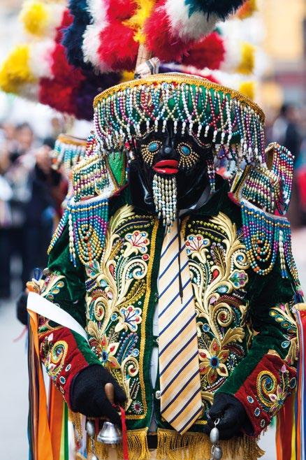
Festivity of Negritos de Huánuco in honor of the Child Jesus
Tinkuy Carnival Feb. - mar.
Locro de gallina and picante de cuy are popular. Potato is used in savory preparations such as pachamanca, and in desserts such as sweet potato. Desserts such as prestiños and picarones are not to be missed. To drink, the chicha de jora, aguajina (aguaje drink), shacta and chicha de molle stand out. In Tingo María you must try the juanes, tacacho with cecina, stir-fry of cecina and frozen coffee.
In Huánuco, craftsmen produce artwork with straw and cabuya fiber, a kind of local cactus. Its embroidery, masks, ceramics and carvings in leather, horn and topa wood are also traditional.

iperu@promperu.gob.pe
The information contained in this brochure has been updated in September 2023. To prepare it, PROMPERÚ has used information from the Regional Directorate of Foreign Trade and Tourism (DIRCETUR) - Huánuco and other official sources.
The opening hours and telephone numbers are subject to vary at each tourist attraction. Confirm the hours and telephone numbers with IPERÚ.
Published by PROMPERÚ - Peru for Exports and Tourism Promotion Agency Calle Uno Oeste 50, 14th Floor, Urb. Córpac, San Isidro, Lima, Perú Tel. +511 616-7300 www.promperu.gob.pe © PROMPERÚ. All rights reserved
Legal Deposit in Biblioteca Nacional del Perú No. 2023-10875
Printed by WORK UP E. I. R. L. (Calle Albert Einstein 165, Ate, Lima) Lima, October 2023