S. Genesio Altopiano del Salto Jenesien - Salten
ER tr.
o ensteinstr. Via B. Arrig egg
e
o nic
p Gam
V ia R
e n cio
L
arc o d’Is i n a V. Pi PIANI DI BOLZANO BOZNER BODEN
ano Via del Mac V. C el Via May lo Schlachth r Nusserofstr Via di Mezzo ai Piani Mitterweg Str. . P.te Virgolo F I U ME I Virglbrücke SAR CO Innsb rucke r Str . - Via P.te Campiglio EISACK Innsbru Kampillerbrücke ck
4 00
Rentscher S tr.
aB
olza
A
re n n
e ro /
B ahnlin
i e B oz
en- B
re n n
hn
S. Martino St. Martin
na
o
Castel Campegno Schloss Kampenn
de
Bolzano Nord Bozen Nord
Brennero Brenner
Cardano Kardaun
Colle di Villa Bauernkohlern
rg o l
ggiata Passe
Zona vinicola Costa Weingebiet Leitach
er
Cardano-Kardaun
A22 Autostrada del Brennero - Brenner Autoba
Funivia del Colle Kohlerer Seilbahn
l Vi
o
no -B
de
me lpro Virg
i - Str.
Via
ic lio N ure
Altopiano del Renon Ritten
RENCIO - RENTSCH
Via Macello - S c hl
r.
-S t
St. Vig ilstr. Via S. Vigilio ud
3 90
Lee gto rw eg
V ia
Funivia del Renon Rittner Seilbahn
Val d’Ega Eggental Latemar Catinaccio Rosengarten
Bagni S. Isidoro Bad St. Isidor
ASLAGO - HASLACH
Colle - Kohlern 1.134 m
OLTRISARCO - OBERAU
t r.
Via Via
el-S
t r.
ürer
-Str.
na lini
ahn /B
ona Pfar
r hof
s t r.
Ve r vo g
Bike Sharing
Cimitero comunale Städtischer Friedhof
Zona sportiva Maso della Pieve Sportzone Pfarrhof
Trento-Trient Verona
Aeroporto Flugplatz
Tourist Information Municipio / Rathaus Town hall / Mairie
Carabinieri Vigili urbani / Stadtpolizei Municipal Police / Police Municipale
Stazione FS / Hauptbahnhof Railway station / Gare Deposito bagagli / Gepäckaufbewahrung Left-luggage office Base Camp Dolomites Stazione autocorriere / Busbahnhof (Überlandlinien) / Bus station / Gare routière Aeroporto / Flughafen / Airport / Aéroport
Ospedale / Krankenhaus Hospital / Hôpital
Parcheggio / Parkplatz / Parking
Posta centrale / Postamt Post office / Poste centrale
WC pubblico / Öffentliche Toilette / Public toilet
Taxi
Teatro / Theater / Theatre / Théâtre
Ciclabile / Fahrradweg / Bike path
Conservatorio / Konservatorium Conservatory / Conservatoire
Zona a traffico limitato Verkehrsbeschränkte Zone
Auditorium Haydn
Centro culturale Trevi / Kulturzentrum Trevi Cultural centre Trevi / Centre Culturel Trevi Università / Universität University / Université Biblioteca / Bibliothek Library / Bibliothéque
donnerstags von April bis Oktober
Tour in bici guidato da Laives Tourismusverein Leifers Branzoll Pfatten Associazione turistica Laives Bronzolo Vadena
Noleggio bici – Radverlieh - Bike Rental
Castello / Schloss / Castle / Château Fiera / Messe / Fair / Faire
Südtirol Rad Alto Adige Via Renon - Rittner Strasse 45 www.suedtirol-rad.com
Sala congressi / Tagungszentrum Congress centre / Centre aux congresses Parco giochi / Kinderspielplatz Play ground / Plaine de jeux Impianti sportivi / Sportanlagen Sport centre / Etablissement sportif
Franziskanergasse 3 via Francescani Museumstraße 10 via Museo Weintraubengasse 44 via Grappoli Bindergasse 2 via dei Bottai Obstplatz 8/9 piazza delle Erbe Rentschner Straße 43 via Rencio Quireiner Straße 8 via S. Quirino Vittorio Veneto Straße 11 via Vittorio Veneto
Geführte Radtour ab Leifers
Punti ricarica E-Bike E-Bike-Ladestationen E-Bike recharging points
Museo / Museum / Museum / Musée
www.franziskanerbaeckerei.it Hier finden Sie uns • Dove siamo
ogni giovedì da aprile ad ottobre
Stazione di pompaggio Pumpstationen Pumping station
e ro
n- V
oze
eB
r.
i-St
no -
K ra
Via D
tze Gru
van olza
Palaonda Eiswelle
Schneiderwiesen
Castel Flavon - Haselburg
Info Punti d’acqua potabile Trinkwasserstellen Potable water points
Colle dei Signori Herrenkohlern
Cla
a
S. Maddalena St. Magdalena
no lza i Bo eg ni d od e n w a i P V i a z n er B tr. Bo r-S
ho a c ht
V. SüdAtiltroo leAdige rstr.
V. Carducci-Str.
Via Dante-Str.
Via Weggen s t
V. Tal ve Sparka ra Talf ssenstr.
ia Rosmini - Str. V. C. di R isparmio
r. V.le Venezia Venedigerstr. lvera San Quirino Lungota FIUME TALVERA
iners t Quire
rino . Qui V ia S
H Selig einrichstr.
Lun Cador gota n astr. lvera G ri es Lun - Griese gota r Was lvera serm Bolz au ano B ozner Wasse rma ue
Cad orn a Via
TALF ER
r-S tr. ax Va llie
V. M
V. M ont ello -St r.
Horazstr.
Corso Italia Italien-Allee
V. Amba Alagi-Str .
e z s t rn. ze
Rovigo-Str.
Via
r. -St cia
ust
P.za Oltrisarco Oberauplatz
Zona vinicola S. Maddalena Weingebiet St. Magdalena
Virgolo - Virgl
lo d
V. P
Str . ttiino
Pac Via
Lan ie -S
zzo - G rutzenweg
ste
ale
rmo
-St
r.
V. Sorren to-Str.
Via eeg Str
ia
g Au
r. -St
nade
Osw ald we g
Polizia / Fremdenpolizei / Police
e
Cu r
viar
aria
f e r ro
V. M
- S t r.
ia B
Fiera - Messe te i n
Via P oloStr.
della
-Str .
Linea
d-Ge berD
ann
aso
Eins
ltm
nw eg
SALEWA-CUBE
Via W altra u
Via
S. A
V ia M
Trento-Trient Verona
Via B uozz to -S i-St t r. r.
Alumix
Gal
Via
Giot
Vi Via A a Ipazia . Me -Str. ucciV ia T Str. o ni E b ne r V ia G . Di Vittor Str. io-Str.
Via
Via
n St r.
Buo zziStr.
t r.
Str.
Via
er-S Ke p l
P.zza Verdi Platz
m
Campo di atletica leggera Leichtathletikplatz
Via avon - Küepachwe C a stel Fl g
V. Ro nco Ne
V. Alessandria-Str.
Edis o
ia Roma
igna lla V V. de
Via Parma-Str.
Via Resia Reschenstr. Via Similaun-Str.
V ia T . A.
Volt a-
Via Agr u
E EA DIG
V ia
Romstr. V
V. Colo gna Glaninge r we g
g
weg rten
inga We Via C. M. Giulini-Str. V. G. Puccini-Str.
Via Ortles Ortler Str.
mo-Str.
Via N. Ras
n
FIU M
o lin o Müh
no Meranerstr. Via Mera
Via Leopoldo L eopoldstr. ETS CH
Mera
tr.
Pie v
FIUME ADIGE ETSCH
ozen-
ic
i-S ell
Bolzano Sud Bozen Süd
Via
Tre nto -Tr ien t
. -Str
ro m e
fst r.
/ Bahnlinie B
r To r Via
tro des
Via Agr u zzo
leo Gali
lei Gali
aldp
m
Chiesa del Calvario e di S.Vigilio Kalvarienberg mit St. Vigl ude Geltr eg V. S. rtraudw St. Ge
-Merano
a G enov V ia G CK EISA rco obahn o Isa t Lung nner Au e l a n re B Argi ero renn del B a d a r utost A22 A Via Sie me ns -St r.
Via
V iale
. Os val do
r. P.zza Stazione aldi - St Bahnhofsplatz Garib
P.te Loreto Brücke
tnerstr. Trien
to Tren
aS
Via Vintler-Str.
P.te Roma Rombrücke
str. kufer Eisac P.te Palermo Palermobrücke
V
lzano
str. enua
piazzetta Hans e Sophie Scholl Hans und Sophie Scholl Platz
O sw
V V. And ia Cavour-S t reas H ofer-S r. tr. P.zza Erbe V. Dr.Streiter-Gasse P.zza Dogana Obstmarkt Zollstange V. M useo - Muse umstr. Portici V. Brenn Lauben Ötzi ero Bre Via Pi a ve - Str. nner V. L. da Vinc Str. i-Str. Piazza - Str. P.zza Domenicani Walther V. Crispi Dominikanerplatz Platz
P.te Druso Via Marconi-Str. Drususbrücke
Fir Via loren F Tri e Viale
S. Osvaldo - St. Oswald
ldo
i
a Bo rco isa o g Lun
Via B
r. ari-St
E
FIUM
CO ISAR
llee
anger Gasse
s va
iar
iari r kufe isac E s hte Rec
V. B erg
P.te Talvera P.zza Vittoria Talferbr. Siegesplatz
V.Vanga W
St. Peter
S. O
ov
rov
Merano Meran
Via Cag liari-S tr.
P.te Resia Reschenbrücke
im ria h e
g we
Mailandstr.
P.zza Don Bosco Platz
Via Piacenza-Str.
Pass. della memoria
a
r. atienstr. urinst Via Dalmazia Dalm ino T r o T Via P.zza Matteotti Platz
tr. o-S am
fer
Castel Firmiano - Schloss Sigmundskron
Via SassariStr.
Europaallee weg uch
V ia V i s i t a z io n e - M
Drususa
lla Neustifterweg V. Novace
erg.
ta
err
ea
MMM Firmian
Via Mil ano
e
Via Orazio
Via C. Mareccio Maretschg.
gia
af
L V.le W. A. Mozart-Alle
zi o n isita
Piazza IV Novembre IV November Platz
eg
ine
ubr
V ia V
M Viale Druso
r.
Pa ss
- Str.
Viale Europa
Palasport Stadthalle
in
Caldaro Kaltern
g imwe ariahe
Drususallee
V. G. Deleda
P.zza Tribunale Gerichtsplatz
nast
r
V. Laurin
Merano-Meran (MEBO) Appiano - Eppan Caldaro - Kaltern
Str. oenVia R
Via Capri-Str.
Via Positano-Str. Viale Druso
Allee
Cornaiano - Girlan
inano Sigmundskroner Str. l Firm
Alte Mendelstr.
ndola Via Me
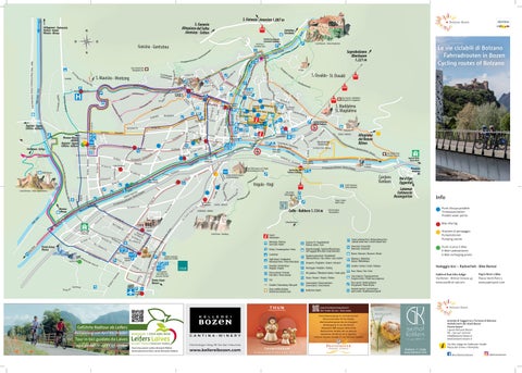
Le vie ciclabili di Bolzano Fahrradrouten in Bozen Cycling routes of Bolzano
Soprabolzano Oberbozen 1.221 m
Vi
V
tr. egal-S ia Pen
ando D
Gun tsch
r. iaz- St
ertà P.zza Mazzini Fre iheitss Platz tr. V. Cesare Battisti-St r.
sta -
Appiano - Eppan Caldaro - Kaltern e Cast
V. R. M
e r-W
Castel Roncolo - Schloss Runkelstein
i V. Bottass e Binderga
e kell
Dre V.T ihe re S ilig an en ti ga sse
a d’Ao
ise n Via E
GRIES
V ia Ar m
r. e - St
llee ia-A avo
a ig n
P.zza Gries Grieserplatz C.so L ib
uc V.le D
lla V Via de
Weingartenweg
V. Marcelli n
di S
Via Lorenz Böhler-Str.
. om hpr c a lb
. P. E V.le
Via Vittorio Venet o-Str.
ago V ia F
tr.
g
V. Pacher-Str. . V.Segantini- S t r
a
V.lo del B Schießstaersaglio ndweg
S. Maurizio - Moritzing
er
nstr. Fage
V. Knoller-S
ri z i o Mo ritzi nge r We
u
n unci
San u
Camping
Zona vinicola Gries Weingebiet Gries
na - G
de ena om r p hna ntsc
Via G
Via
Funivia San Genesio . Jenesiener Seilbahn St r ler Torre Druso nt a r a S Gscheibter Turm ns nto ti n o n e r t. A a S A R Via S VE nio E TAL a S. Anto FIUM Vi P.te S. Antonio St. Anton Brücke
ein W
i el Gunc Passeggiata d
Ma
Superstrada Merano- Bolzano / Schnellstrasse Meran- Bozen MEBO
Guncina - Guntschna
Sarentino Sarnthein
TAL F
Settequerce - Siebeneich Terlano -Terlan Merano - Meran
Via
S. Genesio -Jenesien 1.087 m
hotel. restaurant. idyll.
Papin Rent a Bike Piazza Verdi Platz 5 www.papinsport.com
Azienda di Soggiorno e Turismo di Bolzano Verkehrsamt der Stadt Bozen Tourist board I-39100 Bolzano Bozen Tel. +39 0471 307000 info@bolzano-bozen.it www.bolzano-bozen.it
Kohlern Kohlern11, 11 Bozen Colle www.kohlern.com www.kohlern.com
Via Alto Adige 60 Südtiroler Straße Piazza del Grano 11 Kornplatz @visitbolzanobozen
@bolzanobozen
Le vie ciclabili di Bolzano
Fahrradrouten in Bozen
URBAN2
MERANO, CITTÀ GIARDINO
URBAN2
8 km, 30 metri di dislivello
Fino a Merano: 32 km, 70 metri di dislivello – Tour completo 64 km
8 km, Höhenunterschied: 30 m
Partiamo da piazza della Vittoria, a ridosso del polmone verde dei prati del Talvera, nel cuore del quartiere razionalista per iniziare un percorso squisitamente urbano lungo i bei portici di corso Libertà, impreziositi da locali e negozi per raggiungere piazza Gries, altro punto di riferimento della città di Bolzano. Dalla chiesa dei Benedettini di Muri Gries che troneggia sulla piazza, lasciamo la rotonda in direzione Ospedale (seconda uscita a destra) per percorrere via Vittorio Veneto. Questa via è parte di uno dei quartieri residenziali più prestigiosi della città, sede di ville e residenze storiche, ma anche luogo dove la cultura contadina resiste attraverso la cura dei bellissimi vigneti, molti dei quali vocati alla produzione del tipico vino bolzanino Lagrein. Dall’Ospedale, sempre sulla ciclabile, ci si riconnette con via Merano e via Resia addentrandosi in quelli che una volta erano i quartieri abitati dalle famiglie operaie della zona industriale. Merita una sosta rispettosa, a circa metà di via Resia, al numero civico 80, il muro di cinta dell’ex Lager, una delle stazioni dei luoghi della memoria, dal quale vennero deportate numerose vittime destinate a diversi campi di concentramento in Germania. Il percorso prosegue da qui sulle sicure ciclabili di viale Europa, via Capri e via Roen fino in piazza del Tribunale, pregevole esempio di architettura razionalista con i due edifici del Tribunale e dei palazzi finanziari. Su quest’ultimo troneggia il bassorilievo di Hans Piffrader, di chiara epoca fascista, seppur ultimato dopo la guerra, storicizzato dalla celebre frase di Hannah Arendt “nessuno ha il diritto di obbedire”. Al centro della piazza fa bella mostra di sé la fontana delle Naiadi. Imboccando da qui l’adiacente corso Italia ci si ricongiunge a corso Libertà per far ritorno a piazza della Vittoria. Il percorso si affaccia sulle diverse architetture della città che simboleggiano epoche diverse e uno sviluppo della città tutto orientato a sud-ovest, un percorso che cela interessi inaspettati e una qualità di alto livello, in parte con motivi di riflessione sulla travagliata storia dei due dopoguerra, riflessi che ancora oggi un attento visitatore può respirare in tono originale.
NATURA & MURA ANTICHE 13,6 km, 80 metri di dislivello Poche realtà della dimensione di Bolzano godono della vista di residenze e castelli nelle immediate vicinanze se non addirittura nel centro cittadino, una densità che riporta alla storia dello sviluppo della città voluta dal Vescovo Ulderico di Trento e ben presto, grazie alla successiva appartenenza alla contea del Tirolo ed alla sua favorevole posizione geografica, degna di un notevole sviluppo di commercio, tanto da divenire sede di ben quattro delle più importanti fiere dell’arco alpino. Un luogo strategico per costruire fortezze, ma anche un mezzo per mostrare il proprio status, attraverso costruzioni erette in luoghi impervi o in centro città, affrescate secondo le mode e i gusti del tempo. Per questo tour si parte da piazza Walther per raggiungere attraverso il centro in direzione occidentale il greto del torrente Talvera e costeggiare le belle passeggiate pianeggianti, il polmone verde del centro cittadino, congiunzione fra l’urbanità e la natura che si insinua nel centro urbano. Sulla sinistra orografica, collocato in due ettari di vigneto Lagrein si erge Castel Mareccio, centro di manifestazioni e convegni, per poi puntare con la bussola di Castel Rafenstein verso Castel Roncolo, il maniero illustrato, custode del più importante ciclo di affreschi profani medievali dell’arco alpino. Ivi si narrano l’amor cortese, i giochi sociali, le partite di caccia e pesca, le allegorie di personaggi famosi nella storia della letteratura e nei miti europei, nonché la leggenda di Tristano ed Isotta, segno che già nel XIV secolo gli scambi con la cultura in voga in Europa erano abituali, non solo accettati, ma ricercati. Riscendendo la destra orografica del Talvera si attraversa tutta la città in un tripudio di colori e giardini ben curati sui quali si affacciano gli edifici dei vari quartieri per arrivare, dopo ponte Resia e il quartiere Casanova, al bivio per Merano. Risalendo l’Adige si arriva alla stazione di Ponte Adige dalla quale si può raggiungere Castel Firmiano, uno dei castelli del famoso alpinista Reinhold Messner, sede del museo MMM Firmian; un must per chi vuole non solo fare un tuffo nella storia dell’Alto Adige in un luogo che è stato emblematico nei secoli fino ai giorni nostri, ma anche per coloro che sono incuriositi dal rapporto uomo-montagna che in esso si profila. Il ritorno in piazza Walther può avvenire sullo stesso percorso dell’andata oppure sulla direttissima via Castel Firmiano, via Druso, via Capri, via Roen, piazza Tribunale, piazza della Vittoria e ponte Talvera fino in centro.
LA STRADA DEL VINO Fino ad Ora: 35 km, 280 metri di dislivello – Tour completo 53 km, 290 metri dislivello Il percorso parte dalla realtà urbana di Bolzano per addentrarsi nello spettacolare saliscendi della Strada del Vino dell’Alto Adige con le colline, i sentieri impreziositi dai filari di vite, la vista spettacolare sulla vallata dell’Adige, i suoi laghi e il contorno montano, spesso innevato fino a stagione inoltrata. Partendo da piazza della Vittoria si prende la ciclabile lungo il torrente Talvera in direzione di viale Trieste e costeggiando l’Isarco destro fino al bivio Appiano/Merano si raggiunge il ponte di ferro. Si prosegue poi in direzione Appiano con vista sulle belle residenze e i castelli medievali, per arrivare prima a Caldaro con l’omonimo lago e infine ad Ora. Il rientro è possibile in treno oppure percorrendo la ciclabile lungo il fiume Adige fino a Bolzano. Tutto il percorso è costellato di ottime cantine vinicole, con possibilità di sosta per una degustazione.
Prendendo come punto di partenza piazza della Vittoria si imbocca la ciclabile lungo il torrente Talvera per imboccare la direzione di viale Trieste e costeggiando l’Isarco destro fino al bivio Appiano/Merano, si prosegue senza mai lasciare la ciclabile fino alla bella città del Burgraviato con le sue passeggiate, i bei locali attorno al Kurhaus e i Portici. Meritano una visita le Terme con le piscine e la SPA, i giardini di Trautmannsdorff con il Museo del Turismo e Palazzo Mamming. Lungo il percorso sono possibili deviazioni verso i pittoreschi paesi della valle dell’Adige: Terlano, Vilpiano, Lana con il Museo della Mela e l’altare gotico di Hans Schnatterpeck nella chiesa Parrocchiale di Lana di Sotto. Anche in questo percorso è possibile il rientro in treno che collega ogni ora la città del Passirio con il capoluogo. E ancora…
IL LAGREIN STORICO: GRIES E SAN MAURIZIO 11, 5 km, 100 metri di dislivello Questo percorso si sviluppa tra le vie, poco trafficate, e le ciclabili cittadine nei quartieri di Gries, in via Fago e sulle passeggiate del Lungo Talvera attraversando i territori storici del Lagrein sul cosiddetto conoide del torrente Talvera, partendo da San Maurizio e Gries per raggiungere i vigneti presenti ancora oggi in centro città.
I VIGNETI LUNGO LE VIE CICLABILI DEL FIUME ISARCO 8,1 km, 130 metri di dislivello In buona parte questo percorso si sviluppa su piste ciclabili pianeggianti, affiancando per lunghi tratti il fiume Isarco e collegando il quartiere di Aslago con i Piani per proseguire fiancheggiando il territorio del S. Maddalena Classico fino al paese di Cardano. La vista sulla collina di Santa Maddalena con l’antica chiesetta sulla sommità è da cartolina. A circa metà del percorso per i più allenati è possibile seguire una breve deviazione molto impegnativa che risale in direzione del Colle in una ripida salita di circa 100 metri di dislivello.
PETER’S* WINE TOUR 17 km, 158 metri di dislivello Partendo da piazza Walther e imboccando via Alto Adige, poi piazza Verdi e finalmente la ciclabile verso nord lungo l’Isarco destro si possono visitare molte delle cantine presenti in città, testimoni di grande cultura e qualità vitivinicola: Nusserhof e Pranzegg, a Cardano la tenuta Unterganzner, rientrando verso la città il Larcherhof e il Griesbauerhof. Fra queste ultime due si può deviare verso il Waldgries e godere dell’imbocco della suggestiva passeggiata dedicata ai vini “Rebe”. Rientrando attraverso via Rencio e Sant’Osvaldo si raggiunge la tenuta Malojer per poi attraversare dopo aver risalito via Beato Arrigo, il torrente Talvera e toccare la tenuta Rottensteiner. Subito dopo si imbocca via Fago per giungere alla tenuta Schmid-Oberrautner, piazza Gries con il Convento Muri e l’omonima cantina e ancora più ad ovest la Cantina Bolzano dalla quale si può rientrare su via Merano e viale Druso.
PETER’S* CASTLE RIDE 20,5 km, 179 metri di dislivello Questo tour tocca i principali castelli della conca bolzanina partendo da Castel Mareccio e toccando, con alcuni metri di dislivello, i castelli che si ergono nelle immediate vicinanze: Castel Roncolo con vista sulla rovina di Castel Rafenstein, Castel Klebenstein/Sant’Antonio, lambendo la torre Druso per arrivare in piazza Gries e proseguire verso San Maurizio. Da quel punto in poi Castel Firmiano rimane a vista. Percorrendo la ciclabile dell’Adige in direzione sud fino all’innovativa Alperia Tower ci si connette con la ciclabile dell’Isarco e si rientra in centro.
ARCHI–TOUR Fino a Gries 15 km, fino a piazza Walther 17 km L’ultimo percorso suggerito tocca i principali stili architettonici che caratterizzano la città oltre le caratteristiche medievali del suo nucleo centrale: Museion, i quartieri razionalisti da piazza della Vittoria fino a piazza Tribunale lungo corso Italia. Rientrando sulla ciclabile dell’Isarco si raggiunge l’innovativa Alperia Tower per poi rientrare nella ben organizzata e piacevole Bolzano Sud con il Salewa Cube, Fiera Bolzano, il NOI Techpark Alto Adige e le vie una volta popolate dalle grandi fabbriche. Si rientra in via Resia per una rispettosa visita al muro del Lager e lungo i nuovi quartieri si rientra in città. I titoli contrassegnati con Peter’s* sono suggerimenti dell’albergatore Peter Trafojer, titolare del rinnovato Hotel Scala Stiegl che con la sua provata passione per la bicicletta ha voluto regalarci per diffondere la cultura dell’urban cycling nella nostra bella ed amata città.
Wir starten vom Siegesplatz, in unmittelbarer Nähe der TalferPromenade - Bozens grüner Lunge. Dieser Platz bildet das Herz des Stadtteils im rationalistischen Baustil. Hier beginnt die ausgesprochen urbane Route entlang der Laubengänge der Freiheitsstraße: ein typischer „Corso“ voller Bars und Geschäfte. Unser erstes Ziel ist der Grieser Platz, ein weiteres Wahrzeichen der Stadt. Hier beherrschen die Benediktinerkirche und das Kloster Muri Gries die Gegend. Wir verlassen den Kreisverkehr in Richtung Krankenhaus (zweite Ausfahrt rechts) und radeln die Vittorio-Veneto-Straße entlang. Diese Straße gehört zu einem der prestigevollsten und grünsten Wohnviertel Bozens, in dem Villen und historische Anwesen inmitteln von Weinpergeln stehen. Gries ist nämlich auch für seine Weinproduktion bekannt, für die jahrhundertealte Pflege bäuerlicher Kultur. Viele dieser Rebflächen dienen der Herstellung des Lagrein, zusammen mit dem St. Magdalener Bozens typischer Rotwein. Der Radweg führt bis vor das Landeskrankenhaus und darüber hinaus über die Meraner Straße in die Reschenstraße. Hier begegnet uns ein ästhetisch völlig anderes Stadtviertel; es handelt sich um das frühere Arbeiter-Wohnviertel im Vorfeld der Industriezone. Auf halber Strecke der Reschenstraße (Hausnummer 80, rechte Straßenseite) befindet sich eine Gedenktafel samt Kunstinstallation: Sie weist auf die Mauerreste des ehemaligen Bozner NS-Durchgangslagers. Dieser Ort ist eine zentrale Etappe des Parcours „Historischen Stätten und Objekte“. Von diesem Lager aus wurden zahlreiche Opfer des Nationalsozialismus in verschiedene deutsche Konzentrationslager deportiert. Die Tour führt auf sicheren Radwegen in die Europaallee und weiter über die Capri- und Roenstraße bis zum Gerichtsplatz, einem schönen Beispiel rationalistischer Architektur mit den zwei sich gegenüberstehenden imposanten Gebäuden von Landesgericht und Finanzgebäude. Letzteres wird vom Relief Hans Piffraders dominiert, das eindeutig aus der Zeit des Faschismus stammt, obwohl es erst nach dem Krieg fertiggestellt wurde. Die monumentalen Spuren der Diktatur wurden letzthin historisiert. Seit Ende 2017 leuchtet auf dem Relief das berühmte Hannah Arendt Zitat „Kein Mensch hat das Recht zu gehorchen“ und macht aus dem Denkmal ein Mahnmal. Davor steht mit seinem Wasserspiel mitten am Platz der Najaden-Brunnen. Angrenzend verläuft die Italienallee Richtung Mazziniplatz, wo sie die Freiheitsstraße kreuzt, auf der man unverzüglich wieder auf den Siegesplatz gelangt. Diese innerstädtische Rad-Tour wirft einen Blick auf die sehr unterschiedlichen Architekturen der Stadt - Spiegel der verschiedenen Epochen und der Entwicklung nach Südwesten hin. Die überraschende Vielfalt von Bauweise und Ästhetik weist auf die verworrene Geschichte des 20. Jahrhunderts, vor allem auf die zwei Nachkriegszeiten. Und sie ermöglicht aufmerksamen Besucher*innen eine Reflexion über Zeitläufe und Menschenschicksale.
NATUR & ALTES GEMÄUER 13,6 km, Höhenunterschied: 80 m Nur wenige Städte von Bozens Größe erfreuen sich in solchem Ausmaß des Anblicks von Burgen, Schlössern und alten Anwesen in unmittelbarer Nähe oder gar in ihrem Zentrum. Die Dichte in und um Bozen ist beachtlich und erzählt uns von der frühen Stadtentwicklung, die hauptsächlich Bischof Ulrich von Trient angestoßen hat und später von der Zugehörigkeit zur Grafschaft Tirol bestimmt war, ebenso von der günstigen geographischen Lage, die bald eine Blütezeit des Handels hervorbrachte – Grund dafür, dass Bozen zum Sitz von vier der wichtigsten Messen im Alpenraum wurde. Kein Wunder, dass Bozens Lage auch für den Festungsbau strategisch wurde, genauso spielte aber beim Bau von Prunkbauten eine Rolle, dass Geld und Macht zur Schau gestellt werden wollen. Das machte man mit Gemäuern, die entweder an unzugänglichen Stellen oder im Stadtzentrum entstanden und die entsprechend der Mode und dem Geschmack der Zeit mit prunkvollen Fresken ausgestattet wurden. Für diese Tour starten wir am Waltherplatz. Die Route führt durch das Zentrum und nach Westen zum Flussbett der Talfer, entlang seiner schönen ebenen Promenaden, der grünen Lunge Bozens. Sie ist die perfekte Verbindung von Urbanität und Natur. Auf der orografisch linken Seite, eingebettet in zwei Hektar Lagrein-Reben, erhebt sich Schloss Maretsch, Kultur- und Kongressstätte. Das Schloss weist wie eine Kompassnadel auf Schloss Rafenstein, das wiederum hindeutet auf „die Bilderburg“ Schloss Runkelstein: Sie ist die Hüterin des bedeutendsten Zyklus profaner mittelalterlicher Fresken im Alpenraum. Die beeindruckenden Wandmalereien stellen höfische Liebe, Gesellschaftsspiele, Jagd- und Fischerei-Szenen dar genauso wie Allegorien berühmter Figuren aus der Literaturgeschichte und aus europäischen Mythen. Besonders berühmt sind die Fresken aus der Erzählung von Tristan und Isolde, ein Zeichen dafür, dass im 14. Jahrhundert auch in Bozen der Austausch mit der in Europa angesagten Kultur gesucht wurde. Auf der orographisch rechten Seite der Talfer kann man am Flussgrün entlang die gesamte Stadt durchqueren – in einem Farbenrausch und mit Blick auf gepflegte Gärten, die von den Gebäuden der sehr unterschiedlichen Stadtteile überragt werden. Nach der Reschen-Brücke gelangt man in den modernen Stadtteil Casanova und zur Abzweigung nach Meran. Wenn man die Etsch entlang gegen die Flussrichtung fährt, erreicht man den Bahnhof von Sigmundskron, von dem aus man Schloss Sigmundskron ansteuern kann. Diese Ruine gehört zu jenen Burgen, die der berühmte Südtiroler Bergsteiger Reinhold Messner bespielt; sie beherbergt das MMM Firmian – ein Muss für alle, die in die wirren Geschichtsläufe des 20. Jahrhunderts eintauchen wollen. Doch das Museum spiegelt darüber hinaus auch die Beziehung zwischen Mensch und Berg wider. Schloss Sigmundskron ist ein emblematischer Ort für die Südtiroler Autonomiegeschichte. Die Rückfahrt zum Waltherplatz kann entweder auf der gleichen Strecke erfolgen oder auf dem direkteren Weg über die Drususstraße, die Capri-, Roenstraße, den Gerichtsplatz, den Siegesplatz und die Talferbrücke.
DIE WEINSTRASSE Bis Auer: 35 km, Höhenunterschied: 280 m – Gesamttour: 53 km, Höhenunterschied: 290 m Die Route beginnt im urbanen Bereich und führt aus dem Stadtzentrum hinaus und durch das spektakuläre Auf und Ab der Südtiroler Weinstraße mit ihren Hügeln, auf den von Rebzeilen verzierten Wegen mit spektakulärem Blick auf das Etschtal, seine Seen und die bergige Umgebung, die oft bis spät im Jahreslauf schneebedeckt sein kann. Ausgehend vom Siegesplatz fahren wir auf dem Radweg entlang des Flusses Talfer in Richtung Triestallee und folgen dem Flusslauf des Eisacks auf seiner rechten Seite zur Kreuzung nach Eppan und Meran bis zur Eisenbrücke. Dann geht es weiter in Richtung Eppan. Der Blick weitet sich und bleibt auf den bemerkenswerten Ansitzen und mittelalterlichen Schlössern haften, um später den Ortskern von
Cycling routes of Bolzano Kaltern und den gleichnamigen See zu erreichen. Ziel ist das Dorf Auer. Die Rückfahrt kann mit der Eisenbahn erfolgen oder auf dem Radweg der Etsch entlang nach Bozen. Auf der gesamten Strecke befinden sich ausgezeichnete Weinkeller, die zum Verweilen und zur Verkostung von edlen Tropfen einladen.
MERAN GARTENSTADT Bis Meran: 32 km, Höhenunterschied: 70 m – Gesamttour: 64 km, Höhenunterschied: 70 m Auch in diesem Fall wählen wir den Siegesplatz als Startpunkt und suchen den Einstieg zum Radweg entlang des Flusses Talfer in Richtung Triestallee. Von dort wechseln wir auf das rechte Ufer des Flusses Eisack und erreichen, immer auf dem Radweg, die Kreuzung Eppan/ Meran. Hier bestimmt in Richtung Meran weiterfahren. Der Radweg nach Meran bringt uns bis ins Zentrum der Gartenstadt, Mittelpunkt des Burggrafenamts. Die Promenaden bestimmen hier den Ton, auch die schönen Lokale in der Nähe des Kurhauses und der Lauben. Einen Besuch wert sind eindeutig die Therme mit ihrem Thermalpark, den Schwimmbecken und dem ganzjährig geöffneten Indoor-SPA, außerdem die Gärten von Schloss Trauttmansdorff mit dem Touriseum, dem Südtiroler Landesmuseum für Tourismus, aber auch Palais Mamming mit dem Meraner Stadtmuseum. Entlang der Strecke laden Abstecher in die malerischen Dörfer des Etschtals: nach Terlan, Vilpian, Lana mit seinem Apfelmuseum und dem gotischen Schnatterpeck-Altar in der Pfarrkirche von Unterlana. Die Rückfahrt kann mit dem Zug erfolgen; dieser fährt stündlich von der Passerstadt Meran in die Landeshauptstadt Bozen. Und weiter …
HISTORISCHER LAGREIN: GRIES UND MORITZING 11, 5 km, Höhenunterschied: 100 m Dieser Parcours verläuft auf wenig befahrenen Straßen und auf den Radwegen des Stadtteils Gries: der Fagenstraße entlang, am Radweg auf den Promenaden längs der Talfer, um die historischen Gebiete des Lagreins auf dem so genannten Talfer-Flusskegel zu durchqueren. Ausgangspunkt oder Ziel ist der Stadtteil Moritzing. Das Viertel Gries wird so durchquert, um schließlich die zahlreich noch vorhandenen Weinanlagen im Stadtzentrum zu erreichen.
WEINHÜGEL ENTLANG DER RADWEGE AM EISACKDAMM 8,1 km, Höhenunterschied: 130 m Diese Route verläuft größtenteils auf flachen Radwegen, über weite Strecken entlang des Flusses Eisack, der die Ortsteile Haslach und Rentsch verbindet, und weiter zum Gebiet des St. Magdalener Classico und zum Dorf Kardaun. Der Blick auf den St. Magdalener Hügel mit dem alten Kirchlein auf seiner Anhöhe ist postkartenreif. Ungefähr auf der Hälfte der Strecke ist für Geübte ein kurzer steiler Abstecher in Richtung Kohlern möglich, der sehr anspruchsvoll ist, weil etwa 100 Höhenmeter zu bewältigen sind.
PETER’S* WINE TOUR 17 km, Höhenunterschied: 158 m Ausgehend vom Waltherplatz über die Südtiroler Straße, den Verdiplatz und schließlich den Radweg am rechten Eisackufer Richtung Norden kann man viele der städtischen Weinkeller besuchen, die von Weinkultur zeugen – Tradition gepaart mit Qualität: Nusserhof und Pranzegg, in Kardaun das Weingut Unterganzner und, zurück in Richtung Stadt, der Larcherhof und der Griesbauerhof. Zwischen den beiden letzteren zweigt man ab zum Waldgries, wo übrigens die malerische Wanderung „Rebe“ zwischen den Rebzeilen beginnt. Auf der Rückfahrt durch die Stadtteile Rentsch und St. Oswald erreicht man das Weingut Malojer. Von dort aus schlängelt sich die Selig-Heinrich-Straße bis zum Talferbach und dem Weingut Rottensteiner auf der anderen Flussseite. Von hier aus erreicht man die Abzweigung zur Fagenstraße mit dem Wein-Erbhof Schmid-Oberrautner in der Nähe des Grieser Platzes, wo sich auch das Kloster Muri Gries befindet, das für seine historische Weinproduktion bekannt ist. Weiter östlich in Richtung Krankenhaus befindet sich die modernst ausgestattete Kellerei Bozen, auch einen Besuch wert. Die Rückfahrt kann über die Meraner Kreuzung und die Drususstraße abgekürzt werden.
PETER’S* CASTLE RIDE 20,5 km, Höhenunterschied: 179 m Diese Tour führt an den wichtigsten Burgen des Bozner Talbeckens vorbei, ausgehend von Schloss Maretsch im Stadtkern und mit einigen Höhenmetern Aufstieg den Burgen in unmittelbarer Nähe: Schloss Runkelstein mit Blick auf die Ruine von Schloss Rafenstein, Ansitz Klebenstein, den Gscheibten Turm fast berührend, um von dort aus zum Grieser Platz zu gelangen und weiter nach Moritzing. Schloss Sigmundskron ist da schon im Blickfeld. Dem Etsch-Radweg in südlicher Richtung folgend bis zum Alperia Tower (Wärmespeicher des modernen Fernheizwerks), erreicht man die Verbindung zum Eisack-Radweg, der ins Zentrum zurückführt.
ARCHITEK–TOUR Bis Gries: 15 km, bis zum Waltherplatz: 17 km Die letzte unserer Radtour-Empfehlungen durch Bozen berührt die wichtigsten architektonischen Stile, die Bozen außerhalb ihres mittelalterlichen Stadtkerns charakterisieren: das Museion (Museum für moderne und zeitgenössische Kunst), die rationalistisch geprägten Stadtteile um den Siegesplatz, den Gerichtsplatz und entlang der Italienallee. Zurück auf dem Eisackradweg erreichen wir in südlicher Richtung den modernen Alperia-Turm, die Industrie- und Gewerbezone Bozen Süd mit dem Salewa Cube, der Messe Bozen, dem NOI Techpark Südtirol und den Straßen, die einst von großen Industriehallen gesäumt waren. Die Rückfahrt führt der Reschenstraße entlang vorbei an einem wichtigen Gedenkort für die Stadt: zu den Mauerresten des ehemaligen NS-Durchgangslagers. Von hier aus erreicht man das Zentrum, indem man durch die neueren Wohnviertel zurückradelt. Die mit Peter’s* gekennzeichneten Titel sind Tipps aus dem Rad-Fundus des Hoteliers Peter Trafojer, Besitzer des jüngst renovierten Hotels Scala Stiegl. Er hat uns mit seiner Leidenschaft fürs Radfahren ein Geschenk gemacht. Und mit diesen Tipps lassen wir die Kultur des Urban Cycling in unserer Stadt hochleben.
URBAN2 8 km, elevation gain 30 metres Starting from Piazza della Vittoria, right next to the lush, green Talvera promenade, at the heart of the Rationalist district, set off on a wonderfully urban trail. It will take you through the portici of Corso Libertà, lined on either side by cafes, bars and shops, all the way to Piazza Gries, another Bolzano landmark. From the Chiesa dei Benedettini di Muri Gries – the jewel in the crown of the square – head off towards the hospital (Ospedale, second exit on the right of the roundabout) down Via Vittorio Veneto. This road is one of the most prestigious residential areas of the city, full of historic villas and homes. At the same time, though, it is a place where farming and agriculture can be found to this day, reflected in the vineyards, many of which grow grapes used to produce Lagrein, a wine local to Bolzano. Continuing on the cycle path from the hospital, head onto Via Merano and Via Resia and into the area once home to industrial workers and their families. Around halfway down the street, you can stop at number Via Rencio - Reschenstraße 80 at the walls of the transit camp where many victims began their journey to concentration camps in Germany to pay your respects. From here the route continues down the cycle paths on Viale Europa, Via Capri and Via Roen all the way to Piazza del Tribunale. The two court buildings and financial offices on the square are exquisite examples of Rationalist architecture. The real jewel of this architecture is Hans Piffrader’s postwar, fascist-era bas-relief bearing Hannah Arendt’s famous quotation, “Nobody has the right to obey”, written in Italian, German and Ladin. The Fountain of the Naiads stands proudly in the centre of the square. From here, turn onto the adjacent Corso Italia leading to Corso Libertà, which will take you back to Piazza della Vittoria. The route covers a great deal of the city’s architecture representative of the different eras in the city’s history and development. Developing along the southwest, it contains a number of hidden gems, part of which give us pause to reflect on the torment of the two post-war periods. Even today, observant visitors can see traces of this troubled past and feel how the past is never truly forgotten.
NATURE AND ANCIENT WALLS 13.6 km, elevation gain 80 metres Not many places the size of Bolzano can enjoy this kind of view: stately homes and castles practically next to – if not in – the city centre. The sheer number of villas, castles, and manors reflects the history of how this city – originally envisaged by Bishop Ulrich – has developed over time. As it was part of the Countship of Tyrol and by luck of geography, it soon developed so well economically that it became home to no fewer than four of the most important markets and fairs in the Alpine area. It was both a strategic place to build fortresses and a way of showing one’s status by building in inaccessible places or in city centres, frescoed in line with contemporary trends and fashions. This route sets off from Piazza Walther and heads west through the centre to the banks of the Talvera river and goes along the lovely flat promenades, the city’s green belt where urban life and nature become intertwined. To the left in the middle of two hectares of a Lagrein vineyard you can see Castel Mareccio, where events and conferences often take place. From there head to Castel Rafenstein and Castel Roncolo, the illustrated manor, home to the Alps’ most important Medieval profane fresco cycles. The frescoes depict scenes of courtly love, social games, hunting, fishing, allegories of famous historical figures from European myths and legends. The legend of Tristan and Isolde is a reminder that as early as the 14th century cultural exchange in Europe was normal – not merely accepted, but desired. Sloping down to the right of the Talvera, you cross a city resplendent in colour and well-kept gardens next to the buildings of the various districts, crossing the Resia bridge and the Casanova district to the Merano crossroads. Follow the Adige river until Ponte Adige station which will take you to Castel Firmiano, one of the castles owned by the famous mountaineer Reinhold Messner. It is now home to the MMM Firmian, an unmissable experience for anyone who wants to dive into South Tyrol’s history in a building which has been emblematic throughout the ages, as well as for those with an interest in the relationship between mankind and mountains, which this museum explores. You can retrace the same route you took back to Piazza Walther, or you can take the direct route to the centre through Via Castel Firmiano, Viale Druso, Via Capri, Via Roen, Piazza Tribunale, Piazza della Vittoria and the Talvera bridge.
.
MERANO, A GARDEN CITY To Merano: 32 km, elevation gain 70 metres – Full tour: 64 km
Piazza della Vittoria is also the starting point for this route. From here, follow the cycle path along the Talvera towards Viale Trieste and go along the right-hand side of the Isarco to the Appiano/Merano crossroads. From here, stay on the cycle path and follow signs for Merano to the stunning town of Burgraviato with its promenades, beautiful hospitality venues around the Kurhaus, and its Portici. The Terme thermal baths, its pools and spa, the Trautmannsdorff gardens with the Museum of Tourism, and the Palazzo Mamming are all worth a visit. Why not wander off the beaten track and visit some beautiful villages in the Adige valley? Head to Terlano, Vilpiano, and Lana – home to the Museum of Fruit-Growing and the gothic altar designed by Hans Schnatterpeck in the Lana di Sotto parish church. You can head back from here by train, with an hourly service running between Passirio and Bolzano. We are not done yet...
THE HISTORIC LAGREIN: GRIES AND SAN MAURIZIO 11.5 km, elevation gain 100 metres This route goes along low-traffic roads and the cycle paths in the Gries district, along Via Fago and the Lungo Talvera promenades. It crosses the historic Lagrein sites on what is known as the conoid of the Talvera river, starting from San Maurizio and Gries before reaching the vineyards which can still be found in the city centre to this very day.
WINEYARDS ALONG THE ISARCO RIVER CYCLE PATHS 8.1 km, elevation gain 130 metres Most of this route follows custom-built cycle paths and stretches of it follow the Isarco river, connecting the Aslago district with the Piani district. It then hugs along the side of Santa Maddalena as far as the town of Cardano. The view of the Santa Maddalena hill with the tiny ancient church perched on top is simply picture perfect. Roughly halfway along the route, more experienced cyclists might want to take a short but difficult detour towards the Colle, with a rapid ascent boasting an elevation gain of some 100 metres.
PETER’S* WINE TOUR 17 km, elevation gain 158 metres Setting out from Piazza Walther to enter Via Alto Adige across Piazza Verdi and, lastly, the cycle path northwards along the right-hand side of the Isarco, you can visit many of the town’s wine cellars. These wine estates reflect the quality and prestige of winemaking in the region: Nusserhof and Pranzegg, the Unterganzer estate in Cardano, and the Larcherhof and Griesbauerhof on the way back into the city. Between the Larcherhof and Griesbauerhof you can also take a detour and enjoy the start of the the beautiful wine trail “Rebe” dedicated to the vineyards. Returning along Via Rencio and Sant’Osvaldo, you arrive at the Malojer estate before climbing Via Beato Arrigo and crossing the Talvera, skirting the Rottensteiner estate. You then head into Via Fago and continue to the Schmid-Oberrautner estate, Piazza Gries with the Muri Gries Abbey and wine cellar, and further west to the Cantina Bolzano winery. From there you can make your way back along Via Merano and Viale Druso.
PETER’S* CASTLE RIDE 20.5 km, elevation gain 179 metres This tour hits all of the main castles in the Bolzano basin, starting with Castel Mareccio and going up a slight incline towards the neighbouring castles: Castel Roncolo, with a view of the ruins of Castel Rafenstein, Castel Klebenstein/Sant’Antonio, curving around the Druso Tower to reach Piazza Gries and heading towards San Maurizio. From there onwards, you will have a clear view of Castel Firmiano. Following the Adige cycle path southwards to the innovative Alperia tower, you will then join the Isarco cycle path and return to the city centre.
ARCHITEC–TOUR
THE WINE ROAD
To Gries: 15 km – to piazza Walther: 17 km
To Ora: 35 km, elevation gain 280 metres – Full tour: 53 km, elevation gain 290 metres
This last suggested route takes you through the main styles of architecture found in the city and shows off the Medieval features in the town centre: the Museion and the Rationalist architecture on Corso Italia between Piazza della Vittora and Piazza Tribunale. Return on the Isarco cycle path to swing by the innovative Alperia Tower before entering the lovely, well-organised Bolzano Sud – home to the Salewa Cube, Fiera Bolzano, the NOI Techpark Alto Adige and roads where large factories once stood. Then head to Via Resia to pay your respects at the wall of the Holocaust-era transit camp, before returning to the city centre through the new districts.
This route heads out from the centre of Bolzano into the deep winding hills of the Alto Adige Wine Road boasting verdant hills, pathways flanked by rows of vines, an outstanding view of the valley with its lakes, and surrounded by mountains often covered with snow until late in the season. Starting at Piazza della Vittoria, take the cycle path along the Talvera river towards Viale Trieste; then, follow the right-hand side of the Isarco to the Appiano/Merano crossroads. Keep going until you reach the iron bridge. Follow signs to Appiano, with an outstanding view of the Medieval stately homes and castles, and you will reach Caldaro – the town and the lake share a name – and, lastly, Ora. You can take the train back to Bolzano or follow the cycle path alongside the Adige river. Fantastic wine cellars are dotted around this route, so you can sample exquisite labels while you take a break from cycling.
Headings marked Peter’s* are suggestions put together by hotelier Peter Trafojer, owner of the refurbished Hotel Scala Stiegl. He is a passionate cyclist and gave us these suggestions to promote a culture of urban cycling in our beautiful, beloved city.