Landeck EN
Tourist Office Prutz /Faggen
Strengen Tobadill
Fließ Urgen
L17
Kreuzjöchl 2589m
Pillerhöhe
Neuer Zoll Niedergallmigg
1122 m 581 m
l
ta
rg U
Aifneralm
Nedermaiswald Neuegg
Competition.
Salzburg DE
Plattkopf 2 8 93 m
Kufstein Innsbruck
Landeck
TOURIST INFORMATION OFFICETIROL PFUNDS / SPISS
Hexenkopf 3 03 4 m
AT
Riefenkopf 2654m
Geierskopf 2580m
Schafberg 2560m
Re
860 m
7,6 km
7131 Verpeilalm 510 m
4,4 km
#E2
ac
h
Ulrichskapelle
du
Ulrichswald
Ulrichskopf 245 7m
Waterfall
Turning point
Mountain pass
Rest options
Summit
Unmanaged alpine pasture
Main road
Information
Country road
Point of interest
Street
Sight
Border
MTB route
Hiking trail
ra
Direction of travel
e
Sch
St
Bathing lake
weiz
ich
B184
n
ns
tra
rT se
rs
ch
Feichten 7133
Ta l w a l d
R
u
Adlerblick Bergwerksblick
Karlspitze 2918m
2
In n
Anton-RenkHütte Fallender Bach
Zirmesspitze 2 9 45 m
Großer See
Leiterkopf
7132
Gasthaus Berghof
Hochjoch 28 9 6 m
Riedwald
Bergler Fernerkopf 31 0 4 m
Bergwerk Platzertal
Wildmoos B180
3
A
Sunntigwaidschrofen 2552m
750 Pfunds Wand
#B3
264 m
630 m 800 m
5,0 km 4,7 km
1050 m 650 m
8,5 km 4,0 km
10,1 km
8,4 km 2,8 km
751 Bike & Hike Radurschltal
#B3
754 Rund um den Frudiger
#B3
755 Gschneier Alm
#B3
7132 Pfundser Tschey Platzer Alm
#B3
7156 Bike & Hike Frudiger
#B3
1210 m 320 m
11,3 km 7,7 km
25,1 km
11,3 km 1,5 km
14,8 km 2,4 km 9,6 km 1,3 km
7092 Zanders - Fließer Alm 630 m 440 m
Hohenzollernhaus
C
#B3
Spiss
Radurschl alm
Nauders B
#B3
264 m
930 m 240 m
751
4 km
23,9 km 1,5 km
749 Tschingls - St.Ulrich
1080 m 370 m
Gamorkopf 2 769 m 2
#C2
1075 m
Schmalzkopf 2 7 24 m
MTB route – variant
7157 Bike & Hike Matonkopf
840 m 420 m
Platzer Alm
755
Affenkopf 2626m
#C2
21,3 km
Roundabout Pfunds
3
Gaißpleiskopf 27 71m
763 Römerweg-Tour
950 m 770 m
Serneskopf 2 7 03 m
Rauher Kopf 2 695 m
10,6 km 2,2 km
753 Kobler Alm - Gstalda
Pfroslkopf 314 8 m
Gschneier Alm
997 m 420 m
752 Pfundser Ochsenbergalpe #B3
Langezbergalpe
Lahnkopf 247 1 m
9,0 km
Tourist Office Pfunds
Verpeilalm
7156
Greit lk la m m
Rosskopf 24 61 m
ch
Route number
ße
L348
erre
es
Öst
Pf
7132
Brunnwald
Church Cable car
l
755 Ra
751
ße
Pfundser Frudiger 214 0 m
nd
rschlb
Wa l d
Noggels
1
Gamsköpfe 2 8 07m
Langhaus
754
Frudigerkopf 2149 m
Pfunds
749
Tschingls
Rauher Kopf Noggler 2 05 2 m
Entry point
0
7140
St a u se e
#E2
7156
Freibad Pfunds
Gstalda
11
Verpeilschlucht Quellalpin
Matonkopf 216 8 m
Tösener Frudiger 215 3 m
720 m
1.360 m 180 m
Schweikert 2 8 81 m
G e p a ts ch
7133 Langetsbergalpe
750
749
Inn
Hinterkobl
Starting point
h
ltal
18,8 km
753
Kobler Alm
Key
Aussichtspunkt Langetsberg
Gampen
Pleiskopf 24 6 0 m
6,9 km
738 m
Vergötschen
Langetsbergalpe lb a c
bach
rsch
810 m
h
adu
#E1
#E1
ac
Sonnenhof
Spiss
7157
622 m
12,3 km
Gemeindeamt Tösens
Boden
du
7130 Wallfahrtskirche Kaltenbrunn
#D1
nb
Margreid
752 753
Vorderkobl
er
7,2 km 6,0 km
Wand Stube
754
Ra
700 m 260 m
7092
din
7127 Falkauns Alm
752
Kobler Schutzwald
Kreuzjoch 2 69 8 m
ga
3,1 km
Wa n d e r Wa l d 750
Hahntennenberg 2 67 8 m
E
310 m
Ladstatt
Kesselwald
O
L65
R
7129 Schnadinger Weiher
Roter Schrofen 2 7 02 m
U r fe
Stalanzer Alm
ey
Perflkopf
Ochsenbergalpe
In der Keil 2 67 9 m
he
Gallruth Alm
G s a ll
Fendler Alm
7157
sch
TVB Tiroler Oberland
Data sources: Tiroler Oberland Tourismus State of Tyrol – data.tirol.gv.at, © OpenStreetMap contributors
Kaunertal
Sattelklause
Gfrans
Hohleneggkapelle
7131
7138
ri
Praiskopf 24 4 0 m
sc
ße
ta
Toarjoch
Hoher Kopf 24 4 0 m
Fließer Alpe
Muttakopf 2525m
u re
Mittagskopf 2 616 m
Schlanterkopf 2 519 m
Gande Kalvarienkapelle
ra ns t
h
Platz
759
Tschuppbach Obertösens
754
Blauwand 2822m
A-6531 Ried i. O. · Kirchplatz 48 Despite careful amendments and printing errors may occur. T. +43 (0)research, 50 225 100 · office@tiroler-oberland.com The Tourist Board accepts no liability for any errors. www.tiroler-oberland.com
rM
237 m
7138
7109
Langebene
talbach
Concept, cartography & graphics (2025): max2 gmbh – sign & design, Innsbruck www.max2.at
dle
Übersachsen
Vorderer Heuberg 2353m
tt b a c
Nufels
Freitzberg
Tösner
Matthäuskopf 2 743 m
Fen
Tösens
759
Fließer Stieralphütte
Legal Notice Responsibility for content: Tourismusverband Tiroler Oberland
Langwiese
B180
Blautalkopf 2834m
Frudigerkopf 2822m
G a ll ru
Fendels
750 m
#D1
7140 Bike & Hike Stalanzer Alm #D1
G u g g e r Wa l d
7089
L65
Sankt Georgen
763
Hinterer Heuberg 2578m
Gmaierkopf 2 914 m Gmairsee
You can find our current opening hours on our website: IT www.tiroler-oberland.com/service
Rodelswald
Grasse
Brenner
Stuben 40Scuol ReschenCH pass Meran A-6542 Pfunds Bozen Tel. +43(0)50/225300 pfunds@tiroler-oberland.com St. Moritz
Sankt Christina
Madatschen
nn
Arlbergpass
be
LIE
Frauns
763
Ser fauser Feld
Michaelskopf 1892 m
Leitenwald
7127
B odenb ac h
763
763
Speicherteich Hög
Wiesenhof Bichlwies
Gemeindeamt Ried i. O.
7138 Sattelklause-Fendler Alm Variante Eggböden #D2
Falkaunsalm
7130 Wallfahrtskirche Kaltenbrunn
Burgschrofen 2 519 m
Erlebnisbad Prutz
Ried
L19
Serfaus
Arrezkopf 2 8 45 m
Martinsbach L18
ba c h
Badesee Ried 7105
Freinekapelle
Lawenskopf 2 87 7m
TOURIST INFORMATION OFFICE PRUTZ / FAGGEN Hintergasse 2 A-6522 Prutz Tel.Bregenz +43(0)50/225500 Fernpass prutz@tiroler-oberland.com
Fiss
Beutelkopf 17 95 m
Furgler 3004m Berglialpe
Fa gg en
12,0 km 5,0 km
7138 Sattelklause-Fendler Alm #D2
Oberfalpetan
Grünig
759
763
München
Prantach
7130
Prutz
Wolfssee
Inn
Kirchplatz 48 A-6531 Ried i. O. Tel. +43(0)50/225100 office@tiroler-oberland.com
Hinterer Sattelkopf 2 67 0 m
Blankakopf 2 8 92 m
TOURIST INFORMATION OFFICE RIED / TÖSENS
Kauns
Unterfalpetan
Kaunerberg
5,7 km
7109 Ried–Fendels
K a u n e r ta l
www.tiroler-oberland.com www.tiroler-oberland.com
Burg Laudegg
Köpfle 2834m
Ladis
Zwölferkopf 2 59 6 m
Here’s how to participate: Scan the QR code, fill out the short online survey on the topic of „Holiday destination Austria“ – and with a little luck, you could soon escape the daily grind and enjoy a well-deserved break in the Tyrolean Alps. Rotpleiskopf 2 93 6 m Medrigalpe
Summercard BASIC Enjoy numerous regional offers, such as free use of public transport. This card is provided by your host.
© TVB Tiroler Oberland – Rudi Wyhlidal
Faggen
Lader Weiher
1
7129
759
Inn
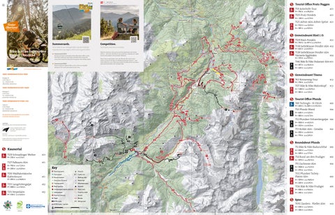
Overview map & routes
Schnadiger Weiher
B180
Speichersee Frommes Frommes 24 8 8 m
Gamsbergspitze Take the chance to share your personal impressions and wishes 3 9 m two-night with us – and with a bit of luck, you could win a2 8relaxing stay for two people in the Tyrolean Oberland.
7125
In n
Tiroler Oberland
Waldkapelle
Obladis
Summercard GOLD Get your premium card easily at the information office or the mountain cableways and enjoy unlimited rides along with many other attractive discounts throughout the holiday region.
Natur- und Wandererlebnis
Gamsbergkopf 2 8 21 m
Participate and win a vacation.
Your ticket to an unforgettable summerholiday experiencein our region with a lot of great offers
Seekopf 2583m
L ahnb ach
Anton Renk & Bike & Hike Experience Stalanz
See
Summercards.
Asterhöfe
Schöngampwald
Straßberger See
Hohe Aifnerspitze 2779m
L63
Wa l d r i e f e
Matekopf 2 24 8 m
#D1
29,2 km
7125 Aifner Alm-Aifner Spitze #D1
Pontlatz
R u n s e g g e r Wa l d
Giggler Spitze 2 614 m Seekopf Kegelkopf 2 8 5 5 m 2 8 3 7m
7105 Prutz-Fendels 530 m
Kleine Aifnerspitze 2558m
Josefskapelle
Pezinerspitze 2550m
#D1
792 m
L76
Hochgallmigg
759 Asterhöfe-Tour
D
E
5,6 km 1,8 km
#A3
Landeck
Route network on the cycle path
Prutz
Innradweg & Via Claudia Augusta
Fiss
In addition to the mountain-biking paths, two longdistance cycle paths also lead through the Tiroler Oberland:
•
Innradweg: This popular long-distance cycle path runs through the middle of the eponymous upper Inn Valley, leading from the proud two- and three-thousand-metre peaks in the Engadine and Tyrol to the rolling hills of Bavaria and Upper Austria. Also along the way: famous cities and heritage sites, as well as culinary delights from three countries. In the Tiroler Oberland, you can still experience the Inn as wild and untamed, just as it should be with a real river that originates in the mountains.
•
755 Gschneier Alm
Faggen
Via Claudia Augusta: This long-distance cycle path is for those who like things not quite fast, but longer. The popular Via Claudia Augusta long-distance cycle path takes ambitious cyclists from Donauwörth in Germany all the way to Venice. Have unforgettable experiences along the historic Roman road and cycle towards the sea, kilometre by kilometre!
Kaunertal
1.080 m
Demanding mountain bike tour in the direction of Pfundser Tschey to the Gschneier Alm.
Serfaus
Tösens
Start Pfunds 966 m
Margreid
1.700m 1.500m 1.300m
2km
1.100m 10km 900m
Pfunds
EASY Family-friendly mountain bike path with a mostly good road surface. Uphill and downhill gradients barely exceed 5%, with a maximum of 15% on short distances. As a rule, there are no special danger areas and, if they exist, they are indicated by special markings (e.g. signs). MEDIUM DIFFICULTY Requires athletic cycling skills and particularly defensive cycling behaviour. Mountain bike equipment is recommended. Uphill and downhill gradients between 5% and 12%, up to a maximum of 17% over short distances. There are confusing, winding sections along the route.
Guidance systems MTB&Single Trail Direction
Route number
754 Rund um den Frudiger
Route number
7089 Wildbachtrail
4km
1.210 m
Route name
Colour-coded icon to indicate difficulty level
Direction
Start Pfunds 966 m
6km
8km
Route name
Arlbergpass
LIE
TIROL AT
CH
Scuol
Reschenpass
Meran Bozen
Infos bike. rental Feeling like a spontaneous tour? – Then rent the right equipment and you‘re ready to go! In the local sports shops, you can rent e-bikes, mountain bikes, and accessories, and start your own tour right away.
TVB Tiroler Oberland
Erlebnisraum Tiroler Oberland A-6531 Ried · Kirchplatz 48 T. +43 (0) 50 225 100 · office@tiroler-oberland.com www.tiroler-oberland.com
Intersport Pregenzer | 6522 Prutz, Dorfstraße 11 | +43 5476 200 86 20 Sport Burtscher | 6531 Ried im Oberinntal, Str. 22 | +43 650 774 35 99 Tom‘s Bikeshop | 6542 Pfunds, Dorf 407 | +43 664 750 700 18 Bacher Bike & More | 6542 Pfunds, Dorf 104 | +43 5476 69 55 40
Take the difficulty of a route into account and make an accurate assessment of your experience and skills as a cyclist. Protect your head with a helmet and check your equipment (brakes, bell, light) before starting every bike tour.
•
Stop at barriers and respect the fact that a particular path is primarily intended for agriculture and forestry. Close pasture gates behind you.
•
Be considerate of nature and wildlife. Do not leave marked routes, do not leave open paths and finish your bike tour before dusk. Do not leave any waste behind.
112 140 Alpine-Emergency Euro-Emergency
10km
900m
Mountain rescue © TVB Tiroler Oberland – Rudi Wyhlidal
Dealing with grazing livestock
10,6 km
1.
Avoid contact with grazing livestock. Do not feed animals and keep a safe distance.
2.
Keep calm; do not frighten grazing cattle.
3.
Mother cows protect their calves; encounters between mother cows and dogs must be avoided.
4.
Keep dogs under control and on a short leash at all times. If an attack by a grazing animal is to be expected, release them immediately.
5.
Do not leave hiking trails on alpine pastures and meadows.
6.
If your path is blocked by grazing cattle, walk around them while keeping as much distance as possible.
7.
If you‘re approached by grazing cattle, stay calm, don‘t turn your back on the animals and avoid them.
8.
Leave pasture areas quickly at the first signs of restlessness among the animals.
9.
Pay attention to fences. If there is a gate, use it, then close it again properly and cross the pasture quickly.
10. Treat the people working here, nature and animals with respect. Start Ried 873 m
Finish Platzer Alm 14,8 km
Start Pfunds 966 m Greit Gasthaus Berghof
755
4km
6km
8km
10km
12km
1.900m 1.700m 1.500m 1.300m 1.100m 900m 14km
Finish Stalanzer Alm 10,6 km Gfrans
The mountains of Tyrol Experience together
1.400m 1.200m 1.000m
© TVB Tiroler Oberland – Rudi Wyhlidal
2km
4km
6km
8km
800m 10km
© TVB Tiroler Oberland – Rudi Wyhlidal
7109 Ried-Fendels 750 m
237 m
7138 Sattelklause-Fendler Alm
12,3 km
622 m
From an idyllic valley to a mountain village: the mountain bike tour to Fendels.
General Information about Guided Bike Tours: Participants must be at least 12 years old to join the e-bike tours What to bring: bike-friendly clothing, drinks, and a small snack. Route changes possible – tours will be adjusted according to the group Contact information Bike programme Ried - H2O Adventures H2O Adventures Ried | Hnr. 231 | 6531 Ried im Oberinntal Contact: +43 (0) 5472 6699 | info@h2o-adventure.at
If you‘re looking for an alternative descent, choose the way back via the Eggböden. From the Fendler Alm, you return to the Sattelklause, where you turn right onto another forest road. This leads back to Fendels via the Eggböden and offers a varied complement to the main route.
Start Fendels 1.352 m
Finish Fendels 12,3 km
Start Ried 873 m
Bike programme Pfunds - Tom‘s Bikeshop Tom‘s Bikeshop | Dorf 407 | 6542 Pfunds Contact: +43 (0) 664 75070018 | info@tomsbikeshop.at
Gfrans
6,9 km
The tour starts at the mountain station of the Ried to Fendels gondola. From here, the path initially leads to the left over a wooden bridge to the nearby car parking. Cross this and follow the road to the right towards Sattelklause and Fendler Alm. The first few metres are easy and paved. On the way you pass the inviting Truyenstube and the idyllically situated St Hubert‘s Chapel. Soon, the landscape opens up and the first alpine meadows line the route. Here the road turns into a gravel path. From now on you need to be more athletic as the path winds steadily uphill in wide, even bends to the Sattelklause. Once you reach the top, the Sattelklause invites you to stop and take a breath. Then comes the last section: an undemanding forest path takes you to the Fendler Alm in about 20 minutes. The rustic Alm is the destination of the tour. Invigorating regional specialities and a magnificent view of the surrounding mountains will quickly make you forget the effort. Return via the Eggböden (alternative route):
The mountain bike route from Ried to Fendels offers a varied cycling experience for sporty cyclists with good basic fitness. The tour starts in the centre of Ried and leads comfortably along the Inn Cycle Path and then turns left towards Langwiese. From here on, you pass by idyllic meadows and farms. Once you get up as far as the hamlet of Gfrans, you come across a barrier that announces the transition to the forest path, which is laid out in a steady climb towards Fendels. Along the whole route you are accompanied by wonderful views of the Upper Inn Valley and the surrounding mountains in the dramatic Tiroler Oberland. In the upper section, you pass shady forests and smaller clearings – perfect for a short break. The route continues on forest and gravel paths through the forest, over the Fendler Mure creek, which is occasionally filled with water, and over the old sled run to Fendels. Once you arrive in Fendels, stop for a rest at one of the inns in the village. If you want, you can continue from here towards Sattelklause or the Fendler Alm (7138 Sattelklause to Fendler Alm).
St. Moritz
IT
8km
From the starting point at the Ried local authority offices, the route first runs through the village of Ried and on the cycle path parallel to the 7109 Ried to Fendels mountain biking route. Passing meadows and farms, it continues gently uphill towards Gfrans, where route 7109 branches off to the left and the Stalanzer Alm Bike & Hike route continues straight ahead on a forest road. The roar of the Stalanzer creek, which only a little further on becomes visible deep down in the gorge, surrounded by the massive Schlanterkopf (2,519 m) and Zirmesspitze (2,945 m) mountains, slowly becomes audible. The path now leads parallel to the Stalanzer Bach, where the road becomes increasingly steep and demanding and requires a high degree of technical skill. Once you have reached the small bridge, you have to climb the last kilometre to the Stalanzer Alm. Nestled on a small plateau, you will then come to the Stalanzer Alm, which is open in summer and invites you to linger and enjoy the breathtaking view of the Anton-Renk Falls. Bear in mind when you take the same way back down, the path is very steep and requires technical cycling skills.
Minimum participants: Guided bike tours will take place with a minimum of three participants. A maximum of 15 people can join each tour so the guides can provide individual attention to each participant.
Brenner
6km
From the starting point in Pfunds, this tour runs parallel to tour 755 Pfunds to Gschneier Alm. If you are still undecided at the start about which tour to take, you can decide at the latest at the Greiter Säge junction. First, follow the ascending asphalt road, past Margreid and Greit to the Greiter Säge and on to the Pfundser Tschey car parking. From here, the breath-taking high valley, with its lush mountain meadows and countless hay barns, opens up ahead of you. Once you have crossed the Tschey and reached its highest point, turn right and a little later you will come to the Platz creek, which leads you further and further into the Platzertal. On the way uphill, you cross several bridges and remain within at least earshot of the Platz creek at all times. After reaching the remains of the former ore and silver processing plant, the gravel path continues until you reach the Platzer Alm at 2,181 m. During the alpine pasture season, you will be provided with drinks and delicacies. If you still have some energy left, you can explore the restored ruins of the old Plaztertal mine, which can be reached on foot. Take the same route on the way back.
Registration bike. programme: Registration is required by 4:30 pm on the evening before. Simply scan the QR code and enter the event code for the bike tour, or register at the information office.
Innsbruck Landeck
4km
Demanding mountain bike tour for technically experienced bikers, with some very steep sections in the last section of the route.
DE
Bregenz
•
1.300m
997 m
All informaion about the guided bike tours.
Kufstein
Be considerate of hikers and pedestrians and overtake at walking pace only.
SOS-EU-Alp App
7140 Bike & Hike Stalanzer-Alm
Infos bike. programme
Fernpass
•
1.500m
Beautiful but difficult tour through the high valley of the Pfundser Tschey and along the thundering Platz creek to the Platzer Alm.
2km
Salzburg
Always ride at a controlled speed so as to allow stopping within half the visible distance, especially on bends, as obstacles can be expected at any time (e.g. stones, branches, temporary wood stores, grazing cattle, cattle grids, barriers, tractors, forestry machines, vehicles of authorised persons).
1.100m 2km
© TVB Tiroler Oberland – Rudi Wyhlidal
14,8 km
Margreid
München
Wildmoos
•
Help in emergencies
Finish Radurschlalm 11,3 km
Ulrichskapelle
7132 Pfundser Tschey - Platzer Alm
Colour-coded icon to indicate difficulty level
DIFFICULT Demanding mountain bike route with numerous hazards. Exceeds the maximum gradient of the red route and with even more challenging route characteristics. Mountain bike equipment is mandatory. Situation-adapted, forward-looking cycling is required.
In contrast to classic mountain bike routes, single trails run not only on forest, alpine and farm roads, but also along narrow paths and climbs. The single trails in the Nauders – Tiroler Oberland – Kaunertal adventure region are also signposted with the official Tyrolean signage system.
A beautiful, but also demanding mountain bike tour through the breathtaking forests of the Radurschl valley. From the starting point at the roundabout, after leaving the cycle path, it continues uphill towards Ulrichs chapel. In the shelter of the trees, this tour is a pleasure even in the height of summer and provides sufficient cooling on the climb of over 800 metres in altitude. Along the slope, the easily passable forest road winds its way into the valley to the valley junction, where you leave the Pfundser Tschey on the left and now follow the Radurschlbach. The forests become lighter and more and more mountain meadows appear as you progress along the valley, making this tour a true nature experience. The Radurschlalm, where you can refresh yourself with drinks or light meals, is peacefully located at the highest point, at an altitude of about 1,800 m. If you still haven‘t had your fill, you can continue to the valley station of the Hohenzollernhaus material cable car and then walk to the Hohenzollernhaus. The route back leads along the same path to the starting point in Pfunds.
Finish Gschneier Alm 11,3 km Greiter Mühle
Rules of conduct
11,3 km
Winding through the wild and romantic Radurschltal, this tour runs through beautiful natural landscapes up to a spot on the Radurschlalm that‘s ideal for a hearty snack.
Innradweg Via Claudia Augusta
Greit Gasthaus Berghof
The Tiroler Oberland offers numerous official mountain bike routes. These are marked and signposted with the Tyrolean mountain biking Model 2.0 guidance system. Driving on all other forest roads, alpine roads and alpine trails is prohibited by the Forest Act.
840 m
From the starting point at the Pfunds roundabout, you wind your way through the narrow streets of the village. As soon as you have left the last houses of Pfunds behind you, the long, challenging climb to the Gschneier Alm begins. The ratio between length and altitude on this tour is quite easy to remember: for every 1 kilometre, the altitude increases by 100 metres. You pass the lower Ackerleweg up to the paved road to Greit and follow it until you reach the hamlet of Greit and the Greiter Säge (half of the tour). In front of the famous Pfundser Tschey, the route branches off to the right over the bridge onto a forest road and continues uphill through the Riedwald forest. You catch a glimpse of the countless haystacks of the Tschey alpine meadows before the tour winds its way over the Gschneier creek into a tributary valley. With the Gschneier Alm now within reach, you can count the last five bends with one hand while drawing on your last reserves of energy. Once you have reached the top, you can enjoy some things you‘ve brought from home. Follow the same route on the descent back to the starting point in Pfunds.
Ried
All mountain bike starting points can be reached along the two long-distance cycle paths.
Nauders
751 Bike & Hike Radurschltal
11,3 km
Finish Fendler Alm 6,9 km
1.400m
Hohleneggkapelle
1.200m 1.000m
© TVB Tiroler Oberland – Rudi Wyhlidal
2km
4km
6km
8km
800m 10km
© TVB Tiroler Oberland – Rudi Wyhlidal
2km
4km
1.600m 1.400m 1.200m 6km