PAGE 8, Friday, August 30, 2019
THE TRIBUNE
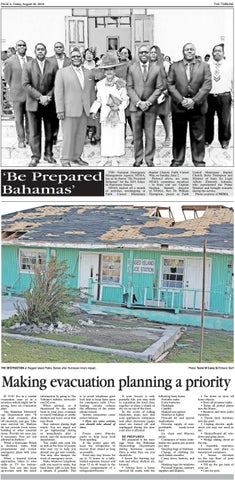
‘Be Prepared Bahamas’
THE National Emergency Management Agency, NEMA, has as its theme “Be Prepared Bahamas” for the 2019 Atlantic Hurricane Season. NEMA kicked off a month of activities worshipping at Faith United Missionary
Baptist Church, Faith United Way, on Sunday, June 2. Pictured above are some NEMA committee members - in front row are Captain Stephen Russell, director of NEMA, Rev Dr William Thompson, pastor at Faith
THE DESTRUCTION at Ragged Island Police Station after Hurricane Irma’s impact.
United Missionary Baptist Church, Betty Thompson and Minister of State for Legal Affairs Elsworth Johnson, who represented the Prime Minister and brought remarks during the service. Photo courtesy of NEMA
Photo: Terrel W Carey Sr/Tribune Staff
Making evacuation planning a priority IF YOU live in a coastal evacuation zone or in a structure which might not be strong, have an evacuation plan. The Bahamas Meteorology Department says: “If you must evacuate, shut off electricity and gas; Take your survival kit. Shelters do not provide food, water, bedding or other essential items. Provide for your pet, if necessary. Pets are not allowed in shelters.” When a Hurricane Watch is declared, make final preparations and review emergency plans with your family. When a tropical system approaches, listen to your radio or TV for instructions. You can also keep up-to-date with the latest
information by going to The Tribune’s website, www.tribune242.com. When advised, or if threatened by the conditions in your area, evacuate to sturdy buildings or public shelters and leave areas that may flood. Stay indoors during high winds. You are urged not to go ‘sightseeing’ during or immediately after a storm, says the meteorology department. You could risk your life as well as the lives of people who may try to help you should you get into trouble. You may also hamper the work of emergency crews. Make whatever telephone calls you need to make, but limit those calls to less than a minute if possible. This
is to avoid telephone gridlock and to keep lines open for emergency calls. Overloading circuits reduces the efficiency of the entire phone system. Storms sometimes cause power failures. • Here are some actions you should take ahead of time: Freeze some blue-ice packs to help keep food from spoiling. If the power goes off, keep the refrigerator or freezer door closed as long as possible. Food may stay frozen for up to 72 hours in a fullyloaded separate freezer and from 12 to 48 hours in the freezer compartment of a refrigerator-freezer.
If your freezer is only partially full, you may wish to reposition the food close together or place a chunk of dry ice on top of the food. In the event of rolling blackouts, make sure that your appliances, computers and other electronic equipment are turned off and unplugged during the time your area is affected. BE PREPARED BE prepared is the message from the Bahamas Meteorology Department during hurricane season. Here is what they say you should do: • Know the warning signals and where shelters are located. • Always have a home survival kit ready, with the
following basic items: Portable radio Extra batteries Flashlight Candles Manual can opener Matches or lighter First-aid kit and special medications Five-day supply of nonperishable, ready-to-eat food Ice chest and blue-ice packs Containers of water (minimum two quarts per person per day) Sleeping bags or blankets Change of clothing for each family member Camp stove, lantern, and fuel Masking tape for windows Personal hygiene, sanitary supplies and diapers.
• Tie down or store all loose objects. • Store all propane tanks. • Bring all potted plants into the house. • Remove and store patio furniture. • Throw deck furniture into the pool. • Unplug electric appliances you may not need or use. • Shutter/board all windows and glass doors. • Wedge sliding doors at the top. • Assemble insurance documents and place in waterproof containers. • Secure elevators on the top floor of your condominium. • Fill up the gas tank of your car. • Care for pets.
THE TRIBUNE
Friday, August 30, 2019, PAGE 9
added to the high tide, creating a storm tide of 17 feet. The combination of high winds and storm tide topped with battering waves can be deadly and cause tremendous property damage along an area of coastline hundreds of miles wide. The destructive power of storm surge and large battering waves can result in loss of life, buildings destroyed, beach and dune erosion and road and bridge damage along the coast. Storm surge can travel several miles inland. In estuaries and bayous, salt water intrusion endangers public health and the environment. The strong winds of a tropical cyclone can cause dangerous waves that pose a significant hazard to mariners and coastal residents and visitors. When the waves break along the coast, they can produce deadly rip currents - even at large distances from the storm. Rip currents are channelled currents of water flowing away from shore, usually extending past the line of breaking waves, that
NE ICA HU RR
A STORM surge is a dome of water topped by battering waves that sweeps the coastline when a hurricane hits shore. At the water’s edge, it is the greatest threat to life and property. Storm surges can be up to 100 miles wide.
E FIL
STORM surge and large waves produced by hurricanes pose the greatest threat to life and property along the coast. Storm surge is an abnormal rise of water generated by a storm’s winds. Storm surge can reach heights well over 20 feet and can span hundreds of miles of coastline. In the northern hemisphere, the highest surge values typically occur in the right front quadrant of a hurricane coincident with onshore flow; in the southern hemisphere, the left front quadrant. More intense and larger hurricanes produce higher surge. In addition, shallower offshore waters contribute to higher storm surge inundation. Storm surge is by far the greatest threat to life and property along the immediate coast. Storm tide is the water level rise during a storm due to the combination of storm surge and the astronomical tide. For example, if a hurricane moves ashore at a high tide of two feet, a 15 foot surge would be
CT FA
STORM SURGE: COULD IT BE THE DEADLIEST PART OF A HURRICANE?
ROUGH seas flood a seawall on the eastern end of Nassau, Bahamas, on Saturday, September 9, 2017, as Hurricane Irma moves along the coast of Cuba. (AP Photo/Tim Aylen) can pull even the strongest swimmers away from shore. In 2008, despite the fact that Hurricane Bertha was more than a 1,000 miles offshore, the storm
resulted in rip currents that killed three people along the New Jersey coast and required 1,500 lifeguard rescues in Ocean City, Maryland, in a week.
In 2009, all six deaths in the United States directly attributable to tropical cyclones occurred as the result of drowning from large waves or strong rip currents.
WHAT TO DO WHEN THE STORM THREATENS
COVER all of your windows. Permanent storm shutters offer the best protection.
WHEN a hurricane threatens your community, be prepared to evacuate if you live in a storm surge risk area. Allow enough time to pack and inform friends and family if you need to leave your home. Secure your home Cover all of your home’s windows. Permanent storm shutters offer the best protection for windows. A second option is to board up windows with 5/8 inch exterior grade or marine plywood, built to fit, and ready to install.
Buy supplies before the hurricane season rather than waiting for the prestorm rush. Stayed tuned in Check the websites of your local National Weather Service office and local government/emergency management office. Find out what type of emergencies could occur and how you should respond. Listen to NOAA Weather Radio or other radio or TV stations for the latest storm news. Follow instructions issued by local
officials. Leave immediately if ordered! If NOT ordered to evacuate: Take refuge in a small interior room, closet, or hallway on the lowest level during the storm. Put as many walls between you and the outside as you can. Stay away from windows, skylights, and glass doors. If the eye of the storm passes over your area, there will be a short period of calm, but at the other side of the eye, the wind speed rapidly increases to hurricane force winds coming from the opposite direction.
PAGE 10, Friday, August 30, 2019
THE TRIBUNE
When the storm hits • PREPARATION – Determine safe evacuation routes inland. – Learn locations of official shelters. – Check emergency equipment, such as flashlights, generators and battery-powered equipment such as cell phones. – Buy food that will keep and store drinking water. – Buy plywood or other material to protect your home if you don’t already have it. – Trim trees and shrubbery so branches don’t fly into your home. – Clear clogged rain gutters and downspouts. – Decide where to move your boat. – Review your insurance policy. – Find pet-friendly hotels on your evacuation route. – Post emergency telephone numbers by the phone. –Inspect your home for items that can move, fall, break or catch fire and correct them. – Have your family learn basic safety measures, such as how and when to turn off water. – Teach children how and when to call the emergency numbers. – Keep enough supplies in your home for at least three days. – Assemble an emergency supplies kit. Store these supplies in sturdy, easy-to-carry containers, such as backpacks or duffle bags. Keep important documents in a waterproof container. Keep a smaller emergency supplies kit in the trunk of your car. – Keep at least a threeday supply of water (one gallon per person, per day); at least, one change of clothing and shoes per person; one blanket or sleeping bag per person – Frequently listen to the radio across the Tribune News Network, go to our
DAMAGES done in Bimini by hurricane Irma. website www.tribune242. com or watch the television. – Fuel and service family vehicles. • DURING A HURRICANE WATCH – Inspect and secure mobile home tie downs. – Ensure you have extra cash on hand. – Prepare to cover all windows and doors with shutters or other shielding materials. – Check batteries and stock up on canned food, first aid supplies, drinking water and medictions. – Bring in light-weight objects such as garbage cans, garden tools, toys and lawn furniture. • DURING A HURRICANE WARNING – Closely monitor radio, TV and the internet. – Close storm shutters. – Follow instructions issued by officials. Leave immediately if ordered!
– Stay with friends or relatives at a low-rise inland hotel or at a designated public shelter outside the flood zone. – Do not stay in a mobile or manufactured home. – Notify neighbours and a family member outside of the warned area of your evacuation plans. Take pets with you if possible, and if the public shelter allows. • DURING THE STORM Plan to leave if you ... – Live in a mobile home. They are unsafe in high winds, no matter how well fastened to the ground. – Live on the coastline, or near a river or a flood plain. – Live in a high rise building. Hurricane winds are stronger at higher elevations. What to bring to a shelter If you are told to leave your home, do so immediately! What to bring to a shelter: First-aid kit (if possible), medicine, prescriptions,
baby food and diapers, games, books, music players with headphones, toiletries, battery-powered radio and cell phone, flashlights, extra batteries, a blanket or sleeping bag for each person, identification, copies of key papers such as insurance policies, cash, credit card Staying in a home – Turn refrigerator to maximum cold and keep it closed. – Turn off utilities if told to do so by authorities. –Turn off propane tanks. – Unplug small appliances. – Fill bathtub and large containers with water in case clean tap water is unavailable. Use water in bath tubs for cleaning and flushing only. Do not drink it. If winds become strong – Stay away from windows and doors, even if they are covered. – Take refuge in a small interior room, closet or hallway.
Photo: Terrel W Carey Sr/Tribune Staff
– Close all interior doors. Secure and brace external doors. – If you are in a two-storey house, go to an interior first floor room. – If you are in a multistorey building and away from water, go to the first or second floor and stay in the halls or other interior rooms away from windows. – Lie on the floor under a table or other sturdy object. Be alert for: – Tornadoes, which are often spawned by hurricanes. – The calm eye of the storm, which may seem like the storm is over. After the eye passes, the winds will change direction and quickly return to hurricane force. • AFTER THE STORM – Keep listening to radio, TV and, if possible, keep checking The Tribune’s website. Wait until an area is declared safe before entering.
– Watch for closed roads. If you come upon a barricade or a flooded road, turn around to avoid danger of drowning. – Stay on firm, dry ground. Moving water only six inches deep can sweep you off your feet. – Standing water may be electrically charged from power lines. – Never use a generator indoors. – Avoid weakened bridges and washed out roads. – Once home, check gas, water and electrical and appliances for damage. – Use a flashlight to inspect damage. Never use candles and other open flames indoors. – Wear proper shoes to prevent cutting feet on sharp debris. – Do not drink or prepare food with tap water until officials say it is safe. – Avoid electrocution by not walking in areas with downed power lines.
SAFETY COMES FIRST WHEN INVESTING IN A GENERATOR By FARRAH JOHNSON LOCAL technicians and electronic retailers revealed the benefits of investing in a good generator and have shared safety tips on how to properly handle the machines this hurricane season. Johann Pyfrom, a certified FG Wilson technician from Pyfrom’s Generator Sales & Service, said generators are ideal due to their convenience. He stated there are two types of generators – portable generators, and those that are permanently installed – and explained that when it comes to purchasing one, a customer will have to choose between “affordability and longevity.” Speaking about portable generators, Mr Pyfrom said: “They are a lot cheaper because they are a cheaper model design which uses two-stroke gasoline engines which they convert into a propane engine.” He added that a diesel engine is a “much better product,” but is worth twice the price. Still, he admitted that he would recommend the diesel generators to “anybody who could afford one,” because while propane generators are more affordable, they last “nowhere near as long” as their counterparts. Mr Pyfrom also added that he would not recommend running a generator during a hurricane, because the objective is to save the generator’s power for the aftermath of the storm. “An engine needs air and fuel and spark to create a combustion. So when you suck in that turbulent air that is around that generator from the hurricane, it’s either too much or the wrong velocity… and it shuts down the engine,” he said. “That’s why our utility company shuts down the
PORTABLE generators are a lot cheaper because they are a cheaper model design which uses two-stroke gasoline engines. Running a generator during a hurricane is not recommended because the objective is to save the generator’s power for the aftermath of the storm. power so you don’t have tragedies like the house burning down from an electrical shortage, or a tree falling on a line pole and the wire pops and kills somebody – that type of thing,” he furthered. Recalling an incident when a young man was electrocuted while handling a portable generator, Mr Pyfrom insisted that patrons should be very careful, because even “highly trained technicians” practice extreme caution when dealing with the machinery. “We know what to look for, and we are very mindful and cautious of what to look for, versus a novice who doesn’t know much,” he said. “The young man was running in the rain, he had a portable generator and a drop chord (and) was standing in water. He had a short (and) he was electrocuted. Those type of things you want to avoid,” he stated. In terms of generator safety, Nick Rademaker from Harbourside Marine One retail store said it is important to ensure a generator is not running in a closed space. He called a 2016 incident when a married couple
died because their generator, installed hours earlier in a washroom off the house, blew deadly carbon monoxide in their home. “The second thing is you want to make sure the generator is the right (one) for the usage, meaning you’re not trying to put too much load on the generator and burn it out and create problems,” he said. Mr Rademaker also said generator owners should make sure that their machine is “in the right application” for what they are using. “Like the R7200 (generator) can run the fridge, freezer, light, and a small air condition, but it can’t run a four or five-bedroom house with the oven, and the dryer, and everything else,” he explained. Patrick Petty, owner of Carib Generators, told The Tribune: “As a rule of thumb a person who is not familiar with a generator - any generator, has no business fooling with it … the secret is don’t wait until a hurricane is on the way to have your generator serviced because the technicians will all be busy and getting to you might not happen.”
Friday, August 30, 2019, PAGE 11
A BOY walks in the floodwaters of Hurricane Irma, in Fort-Liberte, Haiti, on September 8, 2017. Irma rolled past the Dominican Republic and Haiti and battered the Turks and Caicos with waves as high as 20 feet (6 metres). (AP Photo/Dieu Nalio Chery) which means a category two hurricane which hits a major city will likely do far more cumulative damage than a category five hurricane that hits a rural area. The agency cited various hurricanes as reasons for removing the “scientifically inaccurate” information, including Hurricane Katrina (2005) and Hurricane Ike (2008), which both had stronger than estimated storm surges, and Hurricane Charley (2004), which had weaker than estimated storm surge. In 2012, the NHC made slight changes to the windspeed range for category three, four and five hurricanes.
SAFFIR-SIMPSON SCALE CATEGORY 1 Sustained winds of 74-95mph. DAMAGE: very dangerous winds will produce some damage.
HURRICANE KATRINA, above, generated a 27-foot storm tide in Mississippi in 2005.
BACK IN TIME: HISTORY OF STORM HORROR TIDES HURRICANES 1900: Galveston, Texas. A hurricane resulted in more than 8,000 deaths, most by storm tide. 1969: Hurricane Camille produced a 24-foot storm tide in Mississippi. 1989: Hurricane Hugo generated a 20-foot storm tide in South Carolina. 1992: Hurricane Iniki produced a six-foot storm tide on the island of Kauai in Hawaii. 2005: Hurricane Katrina generated a 27-foot storm tide in Mississippi. 2008: Hurricane Ike produced a 20-foot storm tide in Texas. TORNADOES Hurricanes and tropical storms can also produce tornadoes. These tornadoes most often occur in thunderstorms embedded in rain bands well away from the centre of the hurricane; however, they can also occur near the eyewall. Usually, tornadoes produced by
tropical cyclones are relatively weak and short-lived, but they still pose a significant threat. RAINFALL Tropical cyclones often produce widespread, torrential rains in excess of six inches, which may result in deadly and destructive floods. In fact, flooding is the major threat from tropical cyclones for people living inland. Flash flooding, defined as a rapid rise in water levels, can occur quickly due to intense rainfall. Longer term flooding on rivers and streams can persist for several days after the storm. Rainfall amounts are not directly related to the strength of tropical cyclones but rather to the speed and size of the storm, as well as the geography of the area. Slower moving and larger storms produce more rainfall.
MINOR damage to exterior of homes, toppled tree branches, uprooting of smaller trees, extensive damage to power lines, power outages. CATEGORY 2 Sustained winds of 96-110mph. DAMAGE: extremely dangerous winds will cause extensive damage. MAJOR damage to exterior of homes, uprooting of small trees and many roads blocked; guaranteed power outages for long periods – days to weeks. CATEGORY 3 Sustained winds of 111-129mph. DAMAGE: devastating. Extensive damage to exterior of homes; many trees uprooted and many roads blocked; extremely limited availability of water and electricity. CATEGORY 4 Sustained winds of 130156mph. DAMAGE: catastrophic. Loss of roof structure and/or some exterior walls; most trees uprooted and most power lines down; isolated residential areas due to debris pile up; power outages lasting for weeks to months.
NE
HU RR
CATEGORY 5 Sustained winds of 157mph or higher. DAMAGE: catastrophic. A high percentage of homes
Hurricanes pack sustained winds of 74mph or more and gusts can be much faster. With sustained winds of 175mph, Hurricane Gilbert (1988) is the strongest hurricane to hit western hemisphere.
will be destroyed, fallen trees and power lines isolate residential areas; power outages lasting for weeks to months; most areas will be uninhabitable.
E FIL
THE Saffir-Simpson Hurricane Wind Scale classifies hurricanes into five categories based on their sustained wind speed at the indicated time and provides information on wind impacts. The scale does not address the potential for other hurricane-related impacts, such as storm surge, rainfall-induced floods and tornadoes. Hurricanes reaching category three and higher are considered major hurricanes because of their potential for significant loss of life and property. Category one and two storms are still dangerous, however, and require preventive measures. The scale was developed in 1971 by civil engineer Herbert Saffir and meteorologist Bob Simpson, who at the time was director of the US National Hurricane Centre (NHC). The scale was introduced to the general public in 1973, and saw widespread use after Neil Frank replaced Simpson at the helm of the NHC in 1974. The initial scale was developed by Saffir, a structural engineer, who in 1969 went on commission for the United Nations to study low-cost housing in hurricane-prone areas. While performing the study, Saffir realised there was no simple scale for describing the likely effects of a hurricane. Mirroring the utility of the Richter magnitude scale in describing earthquakes, he devised a one-to-five scale based on wind speed that showed expected damage to structures. Saffir gave the scale to the NHC and Simpson added the effects of storm surge and flooding. In 2009, the NHC made moves to eliminate pressure and storm surge ranges from the categories, transforming it into a pure wind scale, called the Simpson Hurricane Wind Scale. The new scale became operational on May 15, 2010. The scale excludes flood ranges, storm surge estimations, rainfall and location,
CT FA
HOW IS A HURRICANE CLASSIFIED?
ICA
THE TRIBUNE
PAGE 12, Friday, August 30, 2019
THE TRIBUNE
THE TRIBUNE TRIBUNE
Friday, August Friday, June 30, 28, 2019, PAGE 13
The warming world
WHEN massive storms inundate coastlines or a veritable “snowpocalypse” keeps a city buried for days, the first question on many minds is: Was climate change to blame? It may play more of a role than previous studies have suggested, according to scientists who advocate a different approach to searching for the fingerprints of warming in extreme weather. In a study detailed in the journal Nature Climate Change, these scientists suggest that if investigations focus on the well-known and robust effects of temperature and increased water vapour in the atmosphere, they will find that these factors tend to exacerbate the impacts of such weather events. Examples in the study ranged from the record-breaking rains and flooding that occurred in Boulder, Colorado, in September 2013 to the devastation of Hurricane Sandy. Not all scientists engaged in the burgeoning field of extreme event attribution agree, though, arguing that the approach advocated in the study doesn’t give a full picture of what led to extreme weather. Still, it could be useful for supplementing other attribution efforts,
or to give some idea of the role of warming played in events that are difficult to represent in climate models, other scientists say. Traditionally, extreme weather attribution efforts have used statistical analyses and climate modelling to examine what role the overall warming of the planet plays in the rarest of weather events. But models are limited in the types of events they can reliably resolve, which can mean that clear climate change impacts - the amount of rain or snow that falls or the severity of a drought or heat wave, for example - could be missed, Kevin Trenberth, a climate scientist at the National Centre for Atmospheric Research (NCAR) in Boulder, and two colleagues argue in the study. Trenberth has long been bothered by news headlines proclaiming that warming was or was not to blame in certain events, and thought that this problem was partly a factor of the way the question of climate change’s role was being approached. Any extreme weather event is affected both by the atmospheric setup that leads to it, such as the patterns of high and low pressure in the atmosphere and
the position of the jet stream, as well as what is called the thermodynamic environment, or the changes in atmospheric temperature and water vapour. Warmer air could mean higher temperatures in a heat wave, or could exacerbate a drought. And because the water vapour in the atmosphere increases by seven per cent for every degree Celsius of warming, it can also mean more fuel for rainstorms. Traditionally, attribution studies have included both aspects to get a full picture of a particular event, but NCAR models have suggested that the change in atmospheric dynamics from warming is swamped by the natural variability of Earth’s climate now (and is likely to be for some time), while the changes to temperature and water vapour are some of the most well understood and robust responses to warming. So Trenberth thinks that taking out the atmospheric circulation from the equation can simplify the question and enable scientists to make clearer statements about the role of warming. In the new study, he and his co-authors examined four extreme events: the February
WAVES slam the Oceana Pier & Pier House Restaurant in Atlantic Beach, North Carolina, last year as Hurricane Florence approaches the area. Photo: Travis Long/The News & Observer via AP
2010 “snowmaggedon” in Washington, DC, Hurricane Sandy, Super Typhoon Haiyan and the torrential rains and flooding in Boulder in September 2013. In all four events, the authors point out, warm sea surface temperatures played a role. In Haiyan and Sandy, that ocean warmth meant a higher sea surface, which meant more storm surge. In the snow and rain events, the warmer waters provided more moisture to fuel snows and rains. Essentially, while the occurrence of each event was in part, or perhaps even almost entirely, a matter of the random, chaotic nature of the atmosphere, climate change helped drive up how extreme they were. (Some of the ocean warming in each case was due to natural variability, but a significant part is the result of man-made warming.) In the case of the flooding in Boulder, a previous study had
concluded that such an event should become less likely with warming. While climate change may have little to no impact on the atmospheric setup of the event, the authors of the study say, it did mean more moisture was available for the rains. Trenberth said he hopes that the attribution community will implement these types of studies. “I hope that the attribution science community will do things rather differently in future, and I think there is a good chance that this will change things substantially, but it may take a few years and meet some resistance,” he said. “But quite a number of colleagues have responded that what we propose makes sense to them.” Others in the attribution community argue that to really know how events might be affected by warming, the full atmospheric picture must be taken into account. “The problem with their proposal is that events are influenced by both dynamic and thermodynamic factors and only by allowing the inclusion of both in attribution analyses can we fully inform decision-making in the face of such extremes,” Peter Stott, who leads the climate monitoring and attribution team at the United Kingdom’s Met Office and works with Climate Central on such efforts, said. It could be that such events become less likely or are relatively unchanged, he added. Stott and others did say that where models can’t resolve events, the types of studies proposed by Trenberth and his co-authors could at least allow them to say something about the possible role of warming. “This approach is useful in that it allows us to simplify our explanations of extreme events’ relation to climate change by focusing on the role of those aspects which are most easily explained and predicted,” Columbia University climate researcher Adam Sobel, who was not involved with the study, said. “That is, we know the planet is warming and that this is causing more moisture to be in the air.”
One storm away
PAGE 14, Friday, August 30, 2019
THE TRIBUNE
ELECTRICITY poles and lines lay toppled on the road after Hurricane Maria hit the eastern region of the island, in Humacao, Puerto Rico, in 2017. Photo: Carlos Giusti/AP By NATARIO MCKENZIE Tribune Business Reporter nmckenzie@tribunemedia.net BAHAMAS Power & Light’s (BPL) ongoing challenges mean this nation could be “one storm away” from a Puerto Ricolike disaster, a Chamber of Commerce executive warned yesterday. Debby Deal, head of the chamber’s energy and environment division, said that ongoing load shedding exercises had exposed just how fragile BPL’s existing generation assets and transmission and distribution (T&D) network are. She expressed concern that a major hurricane could inflict similar devastation on BPL’s energy grid to Hurricane Maria’s 2017 impact on Puerto Rico, which has struggled ever
since to fully restore its power network. Ms Deal described New Providence’s current energy supply situation as “frustrating” for businesses and residents. While BPL’s $95m investment in 132 megawatts (MW) of new generation capacity is set to be installed at its Clifton power plant over the next several months, the utility’s executives have admitted the new engines will not be ready to meet peak summer demand. “I can only say that it’s been frustrating,” Ms Deal said. “Initially they were saying there wouldn’t be any outages, and then they acknowledged that they continue to have challenges. If they could be consistent with what they’re saying it
might be a bit easier for the public. “If they are load shedding then then they should be fair. Some areas are off for far too long based on what I have heard. We are struggling to meet our energy needs and we’re heading into the warmer summer months and into hurricane season. We’re one storm away from being like Puerto Rico.” Ms Deal added: “I don’t know how the small businesses are going to make it like this, the hair dressers, the mom and pop stores, the small businesses that don’t have a generator. This kind of thing is really cutting into the business sector. It’ very sad that we have gotten to this stage. How can a lot of our SMEs start and survive if they don’t have constant supply of energy?”