Geography - Our Vision
Within the geography department we aim to inspire students about the varied, exciting and constantly changing world we live in. Through the study of both physical and human topics, students develop a deep knowledge and understanding of places and environments from across the globe. A mix of enquiry based, decision-making and challenging activities provide the framework for students to expand their geographical, literacy and critical thinking skills whilst also encouraging a reflective approach to their learning. As a result, students leave us as well-informed, open minded, responsible citizens who can play a positive and active role in the 21st Century and flourish in life. Year 7
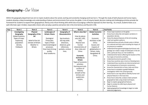
Term 1 Investigating Geography Global locations. Types of maps. Explaining population density. Fieldwork
Term 2 Physical Geography of the UK Relief of the UK. Climate of Britain. Weather in Britain.
Term 3 Landscapes of Britain: Rivers
Term 4 Geography of Gloucestershire
Geological Timescales. Types of Rock Geomorphological processes. River basin & long profile. River landforms
Key locations. OS map skills: directions, distances, grid references, symbols, contour lines.
Term 5 What is Asia like? How do places vary (AC, LIDC, EDC) Physical and human characteristics of Asia, India and China Economic Activities in Britain Types of economic activities. Farming and soils. Location of Industry. Growth of the tertiary and quaternary sectors.
Term 6 Global Economic Activities
End Points
Economic Activities in SW China. Causes and impacts of globalisation in Britain, India, Bangladesh & China.
●
● ●
●
●
● ● ● ● ● ● ● ● ● ● ●
1
Know major locations on the globe. Know how to describe and explain variations in population density. Know the physical features of the UK including relief and weather patterns. Understand how and why climate varies in Britain at a national and local scale including the impact of air pressure on weather. Understand how geomorphological processes and geology can create a range of landscapes in the UK with a particular focus on river landforms. Understand the factors affecting the location of the four types of economic activities. Understand economic growth in Asia. Know how countries vary in terms of development. Understand how countries are interconnected and the consequences of economic connections. Know the characteristics of Asia, India and China Know how to complete a guided fieldwork investigation within the school grounds. Know how to use map skills to identify human and physical features in the local area. Know how to describe, analyse and/or present geographical data using simple techniques. Begin to explain geographical features. Begin to analyse by referring to physical and human features Apply geographical knowledge to begin to make balanced judgements.
Geography - Our Vision
8
Urbanisation Growth of settlements. Urban land use in AC and LIDC cities. Challenges of urban areas. Creating sustainable urban areas. Fieldwork
Coastal Landscapes
Population and Migration
Hydrology & Flooding
Geography of Africa
Coastal processes; formation of wave-cut platforms, stacks and spits; Coastal management
Causes of population growth. Patterns of life expectancy. Causes and impacts of migration.
Water Cycle. Causes of flooding. Hydrographs. Impacts of flooding. Management of floods.
Key locations. Characteristics of Eastern Africa; Physical Geography: climate and biomes. Influence of physical geography on aspects of life e.g. tourism, piracy
International Development
● ● ●
Variations in global development. Causes of variations.
●
● ● ●
●
● ● ● ● ● ● ● ● ●
2
Understand how and why populations change over time. Understand the causes and effects of internal and international migration. Understand how geomorphological processes and geology create varied coastal landscapes and that these short term changes need to be managed in a sustainable manner. Understand how urban areas have grown, the resulting characteristics and how urban areas can be improved sustainably. Understand how changes in the hydrological cycle and human activity cause flooding. Understand how the impacts and responses to flooding vary between countries. Understand the characteristics and locations of selected ecosystems / biomes such as coral reefs, hot deserts, tropical grasslands. Understand how economic activities can be dependent on physical factors (farming in Africa, tourism in Kenya, piracy in Somalia) and international links (tourism, Chinese investment in Africa). Know how and why development levels vary. Know the physical and human characteristics of Africa and factors influencing these characteristics. Know the key locations in the Middle East. In groups, know how to plan and complete a fieldwork investigation within the school grounds. Know how to use OS map evidence to describe landscape features. Know how to describe, present and/or analyse geographical data using more complex techniques. Know how to provide partly developed explanations for geographical features. Analyse geographical issues by referring to social, economic and environmental features. Apply geographical knowledge in order to make balanced judgements.
Geography - Our Vision
Year 9
Term 1
Term 2
Tectonics and Development
Glaciated Landscapes
Earth’s Structure. Processes at plate boundaries. Causes, consequences and responses relating to volcanic eruptions and earthquakes. Methods to improve development levels
Distribution of global ice. Glacial processes. Erosional landforms. Changes in glaciers and the impact on human activity.
Term 3
Term 4
Term 5
Term 6
21st Century Issues: 21st Century Issues: Climate Change Resource Use
GCSE Sustaining Ecosystems
GCSE Sustaining Ecosystems
Causes of climate change. Global variations in emissions. Global variations in impacts. Appropriate solutions to global warming.
What is an Ecosystem? Characteristics of world biomes. Characteristics of Tropical Rainforests
Human use of rainforests. Threats to Rainforests. Case study of sustainable use of rainforests.
Distribution of global resources. Competition for resources. Conflicts arising from resource use.
End Points ● ● ●
●
● ● ● ●
● ●
● ● ●
3
Understand the basic processes occurring at four types of plate boundaries. Understand the causes and consequences of tectonic events. Understand how impacts and responses to tectonic events may vary according to levels of development. Understand how glacial landscapes can change over long periods of time and how human activity can adapt sustainably to these changes. Understand the causes, effects and responses to global climate change. Understand how competition for resources can lead to conflict (Middle East, Arctic). Know how global agreements can be used to tackle climate change. Know the characteristics of global ecosystems and understand the impacts to, and management of, tropical rainforests. Know the key locations in Bangladesh and Russia. Know how to describe, analyse and present geographical data using complex techniques including statistical testing. Know how to provide developed explanations for geographical features. Analyse geographical issues by referring to local, national and global scales. Know how to apply geographical knowledge and place detail in order to make balanced judgements and evaluations.
Geography - Our Vision
GCSE Specification: OCR Geography B Year 10
Term 1 Sustaining Ecosystems – Polar environments. Polar climates with foci on the Arctic and Antarctica. Tectonic Hazards Processes at plate boundaries. Causes. effects and management of volcanoes and earthquakes
Term 2
Term 3
Term 4
Term 5
Term 6
Changing Climates
Distinctive Landscapes
Urban Fieldwork – Gloucester
Rivers Fieldwork – Forest of Dean
Geomorphic processes in coasts, Holderness case study, management strategies
Fieldwork write-up tasks.
Preparing for fieldwork, Carrying out fieldwork in the Forest of Dean, Fieldwork write-up tasks
Climatic Hazards Global atmospheric circulation. Extreme Weather: drought, tropical storms, floods
Changing Climates Long term changes in temperature. Evidence for climate change.
Human and physical causes of climate Change. Impacts of climate change. Distinctive Landscapes Characteristics of landscapes, human and physical impacts on landscapes
End Points ● ●
Urban Fieldwork – Gloucester
Distinctive Landscapes Geomorphic processes in rivers. River Tees case study including human actions.
Preparing for fieldwork and carry out fieldwork
●
● ●
Distinctive Landscapes
●
River Tees case study including human actions.
● ●
●
● ● ● ●
4
Know the characteristics of polar environments. Understand the impacts to, and management of, polar environments. Understand how global air circulation affects weather patterns and the global distribution of biomes. Understand the causes and impacts of extreme and hazardous weather events. Understand the causes, impacts and management of volcanic and seismic events. Understand the long and short term causes of climate change; the evidence to support climate change, and the effects on the UK and wider world. Understand the characteristics of landscapes which make them distinctive. Understand how geology and climate can influence the morphology of river and coastal landscapes, and how human activity, including management, can alter these landscapes. In groups, know how to complete guided fieldwork investigations in human and physical environments outside of the school grounds. Know how to use OS map skills to describe physical landscapes in less familiar situations. Know how to apply analytical skills to a wide range of geographical data. Know how to provide well-developed explanations for varied geographical features. Know how to select and apply relevant knowledge in order to discuss, assess and evaluate geographical issues and reach balanced judgements.
Geography - Our Vision
11
Dynamic Development Factors affecting development, Zambia an LIDC, Rostow’s model /Millennium Development Goals/ Transnational Corporations and trade with the context of Zambia
Urban Futures
Resource Reliance
Urbanisation in LIDCs and ACs, Opportunities and challenges in London and Lagos
Overview of demand and supply for resources (food, water, energy) Food security, food security in Tanzania
UK in the 21st Century
Revision Final exams
UK population change, UK’s changing socioeconomic, cultural and political structure
Revision Final exams
●
●
●
●
●
●
● ● ● ●
5
Understand the nature and causes of differences in development between countries and how these differences can be addressed. Understand how the processes of migration, urbanisation and urban growth affect the characteristics of global cities. Understand how ways of life vary in cities, how this creates challenges in global cities and that these challenges can be addressed sustainably. Understand the causes and impacts of the demand for resources outstripping supply with particular reference to achieving a sustainable food supply and food security. Understand how the UK has changed economically, demographically and socially in the 21st Century including its global connections. Know the physical and human characteristics of the UK including population density, land use, relief and the associated issues of water stress and housing shortages. Know how to use OS map skills to describe human landscapes in less familiar situations. Know how to apply analytical skills to a wide range of geographical data. Know how to provide well-developed explanations for varied geographical features. Know how to select and apply relevant knowledge in order to discuss, assess and evaluate geographical issues and reach balanced and reasoned judgements.
Geography - Our Vision
A Level Specification: OCR Year 12 Teacher 1 (4 lessons per fortnight)
Term 1
Term 2
Term 3
Term 4
Term 5
Term 6
End Points
Exploring Oceans
Exploring Oceans
Exploring Oceans
Exploring Oceans
Exploring Oceans
Earth’s Life Support Systems
●
Characteristics of Oceans
Marine resources. Socio-economic and political factors.
Socio-economic / political factors (continued).
Climate Change
Pollution How important are water and carbon cycles to life on earth?
● ● ●
12 Teacher 2 (4 lessons per fortnight)
Coastal Landscapes
Coastal Landscapes
Changing Places, Making Spaces
Changing Places, Making Spaces
Changing Places, Making Spaces
Earth’s Life Support Systems
Geomorphic processes, Erosional and depositional landforms Coasts as Systems
Emergent and submergent landforms Human activity on coastlines
Place Identity including built environment, physical landscape, demographic, socio-economic, cultural and political characteristics
Understanding places: perception, representation, emotional attachment. Social Inequality Impact of changes in economic activity on places
Impact of changes in economic activity on places. Place making; rebranding
How important are water and carbon cycles to life on earth?
● ●
● ●
● ● ● ● ●
● ●
6
Understand how flows and connections shape the characteristics of places and result in changes to places and people's perceptions of those places. Understand how places can be represented in different ways. Understand how social inequality varies at a local, national and international level. Understand how economic change can impact places and how this is influenced by different players. Understand how places are created through placemaking processes. Understand how coastal landscapes can operate as a system. Understand how coastal landforms develop in high and low energy environments. Understand how climate change and human activity can affect coastal landscapes. Understand how climate change is affecting coastal landscapes and ocean systems including island nations and the Arctic Ocean region. Understand the physical and biological characteristics of oceans. Understand the consequences of human activities on oceans. Understand how socio-economic and political factors have influenced the use of oceans. Understand why carbon and water are important to life on Earth. In groups, know how to plan and complete fieldwork investigations in unfamiliar physical and human environments Know how to create GIS maps using primary fieldwork data. Know how to apply and evaluate analytical skills to a wide range of geographical data.
Geography - Our Vision
●
●
12 NEA (2 lessons per fortnight)
Introduction to fieldwork Planning fieldwork Writing an Introduction Writing methods Northleach fieldwork
Writing up fieldwork investigations Presenting Data ArcGIS maps Analysing Data Writing Conclusions Evaluating fieldwork
Analysing fieldwork data
Fieldwork Preparation
Statistical Tests Data Presentation Initial research for own investigations Safety Investigations
Analysing data from safety investigation Planning Swanage fieldwork Swanage follow-up work
Urban Fieldwork
NEA Preparation
Writing questionnaires Birmingham fieldwork Use of Excel to analyse data
Completing own proposal forms Planning data collection
Term 5
Term 6
●
Know how to explain in detail a variety of geographical processes and features including independently identify and explain links between Exploring Oceans and other A level topics. Know how to apply knowledge and understanding to unknown situations and to construct well-developed, evidenced arguments which reach reasoned conclusions.
Understand how to plan, undertake and evaluate an individual investigation.
Year
Term 1
Term 2
Term 3
Term 4
7
End Points
Geography - Our Vision
13 Teacher 1 (4 lessons per fortnight)
Powers and Borders Challenges to sovereignty and territorial integrity, global governance of conflicts
Hazardous Earth
Hazardous Earth
Hazardous Earth
Processes and features at plate boundaries
Vulcanicity; volcano case studies, management of volcanic hazards
Seismicity; earthquake case studies, management of seismic hazards
Revision
Final Exams
●
● ● ● ● ●
13 Teacher 2 (3 lessons per fortnight)
13 NEA (2 lessons per fortnight)
Global Migration
Global Migration
What are the contemporary patterns of global migration, why has it become increasingly complex and what are the associated issues with unequal flows of global migration?
What are the contemporary patterns of global migration, why has it become increasingly complex and what are the associated issues with unequal flows of global migration?
Writing up NEA: Introduction; Methods
Data Presentation and analysis
Earth Life Support Systems How do the water and carbon cycle operate in contrasting locations. (Tropical rainforest and Arctic Tundra). How much change occurs over time in the water and carbon cycle.
Writing conclusion and evaluation
Earth Life Support Systems
Revision
Final Exams
● ● ●
To what extent are the water and carbon cycle linked and how are they managed globally
● ● ● ●
●
Final checks; contents page; bibliography
Revision for final exams
8
●
Understand how sovereignty and territorial integrity can be challenged, and how global governance can address the consequences of these challenges. Understand how the water and carbon cycles operate in contrasting locations. Understand how water and carbon cycles can change over time. Understand how the water and carbon cycles are linked. Understand contemporary patterns of migration and how these are increasing in complexity. Understand the impacts and issues arising from unequal flows of migrants. Understand the theory of plate tectonics and the evidence to support this theory. Understand the processes occurring at plate boundaries. Know the main hazards generated by volcanic and seismic activity. Understand the impacts, responses and mitigation strategies associated with tectonic hazards. Understand how the risk of a hazard changes over time and is linked to the occurrence of disasters. Know how to create GIS maps independently using own fieldwork data. Know how to explain in detail a variety of geographical processes and features including independently identify and explain links between Tectonics and other topics. Confidently know how to apply knowledge and understanding to unknown situations and to support well-developed, thoughtfully evidenced arguments which reach substantiated conclusions.
Know how to plan, undertake and evaluate an individual investigation.