SURVEYING OF FIRST NATION LANDS MANAGED UNDER THE INDIAN ACT
SURVEYING OF FIRST NATION LANDS MANAGED UNDER THE INDIAN ACT
Cat. No. M124-12/2023E-PDF (Online)
ISBN 978-0-660-48200-2
Aussi disponible en français sous le titre : Arpentage des terres des Premières Nations gérées en vertu d’un code foncier.
© His Majesty the King in Right of Canada, as represented by the Minister of Natural Resources, 2023
This guide, prepared by the Surveyor General Branch, is intended to provide First Nations who are managing a survey project with information, tools and links to additional resources when considering having land survey work conducted on their reserve lands. The format of this guide is intended to enable the reader to determine the level of information they require, whether it is a high-level overview of the survey project process in a checklist-style format or a more detailed explanation of the process, including helpful tools and examples.
This Guide is intended to complement the information provided by the Association of Canada Lands Surveyors in their “Surveys of Indigenous Lands Toolkit” (refer to Appendix 9 for additional information on the Toolkit).
The first section of this guide outlines the survey process, from determining the type of survey plan or land description required to the final approval and recording of the survey plan. The second section builds on the survey process components identified in the first section and provides a more in-depth description of each part of the process. The reader of this guide can determine the amount of detail or information they require for each step and flip back and forth between these two sections depending on the level of information that is needed. The last section of the guide contains examples, additional information and links to other resources related to the survey process.
The three sections in this guide are:
I. An overview of the survey process: This section identifies the four main parts of a survey project and provides a short description of the key activities associated with each part.
II. The Survey Process in Detail: This section provides a detailed description of each of the four main parts of a survey project, including links to additional reference information.
III. Appendices: This section provides additional information, examples and images, the Surveyor General Branch Regional office contact information, roles and responsibilities within the survey process and other helpful links.
Throughout this guide, any numbers shown as superscript text (e.g.,2) are hyperlinks to the applicable appendix in the last section of this guide.
Confirmation that the lands are Reserve Lands (as defined under the Indian Act)
Reserve held in common/jointly with other First Nations
Review of applicable policies and other documents
Review of records and documents (registered and unregistered)
Application of the Interdepartmental Letter of Agreement (ILA)
References in existing documents registered in the Indian Lands Registry System (ILRS)
Existing survey plans and their current uses
Using a textual description (not surveyed)
Determining the survey project Scope of Work (SOW)
Preparing the sketch
Written listing of interests (e.g., Land Status Report)
Exterior boundary surveys
Written survey project agreement
Written permission
First Nation review of the plan
First Nation approval of the plan
Surveyor General Branch review of the plan
First Nation re-approval of the plan
Other plan approvals
Surveyor General Branch signing of the plan
Recording of the plan in the Canada Lands Surveys Records (CLSR)
Filing of the plan in the applicable Provincial or Territorial Land Title/Registry Office
Referencing the plan in the document to be registered
: Considerations for determining the type of survey plan or land description required for a transaction
Appendix 2: Considerations for preparing a textual description (not surveyed)
Appendix 3: Considerations for determining the survey project scope of work and preparation of the required documents
Appendix 4: Defining Canada Lands and a Canada Lands Surveyor (CLS), and how to locate a CLS in your area
Appendix 5: The contents and importance of survey instructions
Appendix 6: Considerations when reviewing and approving the survey plan
Appendix 7: Using the SGB Project Search website to track the status of the survey plan
Appendix 8: Using the SGB Plan Search website to view and download a copy of the recorded survey plan
Appendix 9: Additional Resources and links

AIt is recommended that the First Nation review their applicable policies, records and documents that may relate to or impact the survey project.
BThe First Nation will need to confirm the intent of the proposed transaction to identify the survey plan(s) and/or land description option(s) that may be available for the transaction.1
CWhere it has been determined that an existing survey plan or land description can be used for the transaction,1 no new survey work is needed and no further steps in the survey process is required.
Note:
The First Nation may also contact the Regional Surveyor General Branch office,9 the Regional Indigenous Services Canada office,9 the National and/or Regional Land Managers Association9 or the Canada Lands Surveyor, to assist in reviewing applicable documents, preparing the survey project scope of work and/or required accompanying documentation.
Refer to pages 14 to 26 for a detailed explanation of Part 1.
DWhere a new survey plan is required, the First Nation will identify the survey project scope of work and prepare/obtain the required documents (sketch, Land Status Report, etc.).3
EThe First Nation will contact the Canada Lands Surveyor(s)4 to discuss the survey project and obtain a cost.
The First Nation will hire the Canada Lands Surveyor (CLS), confirm the survey project scope of work, and provide written permission3 for the CLS to access the reserve for the survey.
Depending on the complexities, project scheduling, and other factors of the survey project, the CLS may not be on-site to conduct the field work. Instead, the field crew may carry out the field work requirements under the guidance of the CLS. If desired, confirmation of the CLS’ on-site attendance for the field work can be specified in the survey project scope of work.3
AThe CLS will submit the sketch and written permission to the Surveyor General Branch (SGB) and request survey instructions5 to be issued for the survey project.
BThe CLS will correspond with the First Nation to confirm the timeframe for the field work and any changes to the survey project scope of work and any specific site considerations (i.e., access, safety, etc.).
CThe CLS or field crew may meet with the First Nation, adjoining interest holders or other parties, as required. The field work will conclude with the required measurements being made, the survey monuments being placed, found, flagged, etc., in accordance with the survey instructions and survey project scope of work.3
AThe data collected from the field work will be reviewed and analyzed in the office. Various calculations and checks will be made with the data prior to the drafting of the survey plan.
BThe survey plan is to be prepared in accordance with the National Standards for the Survey of Canada Lands9 (National Standards). The CLS will conduct a quality control check and review of the drafted survey plan.
CNote:
Where changes to the survey project scope of work are required,3 it is important to identify them as early in the project as possible.
“Even though it may seem to be as easy as “moving some lines and text around,” there is a lot more involved in the re-drafting of a plan. There is a lot of data associated/tagged with each point, line and text in a CAD file, moving one line can cause a lot of additional work to address other parts of the digital file.”
Association of Canada Lands Surveyors. (2019). Cost Drivers: Plan Preparation and Office Work [Brochure]
Once the CLS is satisfied the drafted survey plan meets the requirements of the National Standards,9 survey instructions5 and First Nation’s survey project scope of work,3 it will be signed and sent to the First Nation for their review and approval.6

Refer to pages 31 to 33 for a detailed explanation of Part 3.
The First Nation will need to confirm the parties that are required to review and approve the survey plan. It is recommended to have the First Nation’s Land office involved in the review and approval process to ensure they can provide their knowledge and input.6
BUpon receiving the signed survey plan, the First Nation will need to review it and, once satisfied it meets their requirements, provide written approval6 of the survey plan to the CLS.
The CLS will submit the survey plan, written approval, and any other required documents to the Surveyor General Branch for their review7 and recording of the plan.
COnce the survey plan is deemed to meet the requirements of the National Standards,9 and all required approvals7 and documents have been provided, the survey plan is recommended for approval/confirmation.
DThe survey plan is approved/confirmed by an authorized representative of the Surveyor General Branch and recorded in the Canada Lands Surveys Records (CLSR).8 The digital image of the survey plan is made available to the public.
AIt is recommended that the First Nation review their applicable policies, records and documents that may relate to or impact the survey project.
A First Nation will need to confirm that the lands to be surveyed are a reserve as defined under the Indian Act. There are certain situations where a portion of land acquired or currently used by a First Nation, is yet to be confirmed to be reserve lands. For example, where lands have been acquired for an addition to reserve and while the intent is to have them form part of the reserve, they may not have been officially added to the reserve (i.e., through a Ministerial Order). Another example is where there may have been an oversight in the additions to reserve process and even though the lands were transferred to Canada and have been used and occupied by the First Nation for many years, the lands may not have been confirmed as having reserve status through an Order in Council (OIC) or other formal document, due to a missed step in the process. The following documents and/or sources9 may to assist in determining if the lands are confirmed to be reserve lands:
Registered and non-registered
instruments: A search of the ILRS can be conducted to locate those documents (i.e., OIC, Ministerial Order, etc.) that would assist in determining the status of the lands. While all instruments that affect the exterior boundaries of a reserve are intended to be registered in the ILRS, there may be some rare instances where the instrument may not have been registered (whether it is in the process of being registered or was not registered in error). In those situations, a First Nation can contact their local Regional ISC office9 to try to locate and register the document and/or confirm the status of the land.
Order in Council: Prior to the passing of the Addition of Lands to Reserves and Reserve Creation Act in 2018, an OIC would be the main legal instrument used to add lands to or establish a reserve. An OIC would be recommended by the Minister of ISC and then directed through the process to be approved and signed by the Governor General. Due to the numerous processes to be followed to pass an OIC, there could be a significant time delay from the date that it was initially submitted to when it was signed (passed). In the provinces of Alberta, Saskatchewan and Manitoba, a Ministerial Order could be used to set apart lands as an addition to a reserve or to establish a new reserve instead of using an OIC, under the Claim Settlements (Alberta and Saskatchewan) Implementation Act and the Manitoba Claim Settlement Implementation Act, where the agreement with the First Nation was listed in the schedule of the Act.

https://laws-lois.justice.gc.ca/eng/ acts/A-1.3/FullText.html
Ministerial Order(s): Prior to 2018, Ministerial Orders to add lands to or establish a new reserve was limited in use. Upon the passing of the Addition of Lands to Reserves and Reserve Creation Act in 2018, the use of a Ministerial Order was expanded to all First Nations across Canada to add lands to their existing land base.
It is important to thoroughly read the Ministerial Order to confirm its effect, as some Ministerial Orders may only confirm the future intention to add the lands and not actually add the lands to or establish a reserve.
. Regional ISC office: One of the roles of the Regional ISC office9 is to examine, register and record documents related to reserve lands in the ILRS. The Regional ISC office may be able to assist in determining the status of the lands through a search of their files, records and the registered instruments in the ILRS. As their office is also involved in the addition to reserve (ATR) process, they may be able to provide a potential update or timeframe for the completion of the ATR.
Once it is confirmed that the lands to be surveyed are reserve lands, a First Nation will need to determine if there are other applicable policies, records or documents that may affect the survey project.
Where a survey is proposed for a reserve that is held in common or jointly with other First Nations, it is highly recommended that the First Nation that is initiating the survey, discuss the project with the other First Nations and ensure there is an agreement to proceed with the proposed survey project. Written permission for the surveyor to access the reserve, and subsequent written approval for the survey plan, would need to be provided by all of the First Nations that are associated with the reserve. Therefore, it is best for all of the First Nations to be in agreement with the survey project prior to the work being conducted.
A First Nation may have certain requirements, restrictions or policy(s) in relation to a survey that is carried out on their lands. Some First Nations are working on establishing a written survey policy that will clearly identify the authority and roles of their Land Department, the applicant, the forms to be used, etc.
• Where a First Nation has a written survey policy in effect, it is recommended to bring this to the attention of the CLS. The policy may identify the authority for each survey-related activity, such as: who can request a survey, what are the requirements for the survey (i.e., a specific size of lot is required), who can provide written permission for the CLS to access the land for the survey, and who can approve the survey plan.
• Where a First Nation does not have a written survey policy in effect, there is usually an unwritten process that is followed. It is recommended to discuss the expected process to be followed with the CLS.
This document can assist in guiding a First Nation through the survey process and where desired, be used as a source of information to assist in the establishment of their own written survey policy.
The First Nation will need to confirm the current interest(s) in the land to be surveyed. It is recommended that a First Nation:
• Conduct a thorough review of their internal records (i.e., unregistered interests) and the ILRS9 documents to confirm the interest in the land. All current and/or potential interest holders that may be affected by the survey will need to agree to the survey being conducted. Refer to Part 1C. below, for more information regarding the review of applicable records and documents (i.e., Land Status Report).
• Refer to the Band-Reserve Report (under the Reports tab in the ILRS) as it will identify the First Nation(s) associated with the reserve.
• Be aware of any potential or known conflicts, whether boundary- or interest-related. In some situations, it may be necessary to reach a resolution before proceeding with the survey. If you are unsure if a survey should proceed due to a potential conflict, you may want to discuss the issue with the Regional Surveyor General Branch office9 or the Regional ISC office9 before contacting the CLS for a cost.
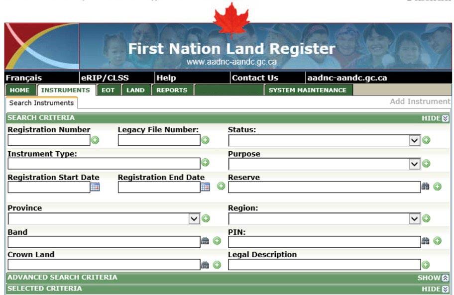
https://services.aadnc-aandc.gc.ca/ILRS_Public/Default.aspx
The First Nation will need to confirm the intent of the proposed transaction to identify the survey plan(s) and/or land description option(s) that may be available for the transaction.1
The minimum required type of survey plan or land description needed for a transaction that is to be registered in the ILRS is determined by aligning both the purpose and term of the proposed transaction within Chart “A” of the Interdepartmental Letter of Agreement.9
The Interdepartmental Letter of Agreement Related to the Cooperation in the Area of Surveys and the Specifications for Descriptions of Land for Transactions on Reserve Lands, 2014 is applicable for surveys conducted on reserve lands managed under the Indian Act.
Chart “A” of the current ILA: This Chart identifies the minimum survey and land description requirements where a transaction is to be registered in the ILRS;9 however, where desired, a First Nation may choose a higher standard of survey or land description for the transaction. For example, a textual description is the minimum requirement for a lease of a building unit for 10 years or less. However, a First Nation may determine that a Plan of Building Unit(s) should be prepared instead. A Plan of Building Unit(s) is considered to be a higher standard of survey and can provide a more concise representation of the unit boundaries (e.g., internal wall measurements, unit area, etc.), exclusive use area(s) (e.g., parking stalls, decks, etc.), measurements and relationship to any other units and the underlying lot boundaries.
Once the type of survey plan required for the transaction has been determined, it is recommended that the First Nation confirm that there is no existing survey plan (recorded in the CLSR8) or land description that could be used.
https://clss.nrcan-rncan.gc.ca/clss/ standards-normes/dl?p=InterdepartmentalAgreement2014_Eng.pdf&type=data
Due to recognizing the need to make improvements on available survey products to support a First Nation’s land management needs, the current ILA9 and National Standards9 have evolved over time and, therefore, the requirements for surveys and land descriptions have changed. A survey plan that may have been accepted for a document to be registered in the ILRS in 2014 based on the previous Chart “A” applicable at that time, may now be different from what is acceptable today due to the current Chart “A.”
While a currently registered interest in the ILRS9 may reference an existing survey plan or land description, if there is an update or transfer to be registered for that interest today, there may be the possibility that same survey plan or land description reference may no longer be suitable for use as it may not meet the current Chart “A” requirements. You will need to use the current Chart “A” requirements for any new transactions to be registered in the ILRS, which includes updates to or transfers of an interest.
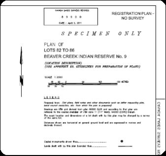

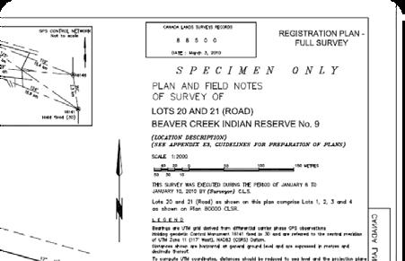
Those Registration Plan – Full Survey plans prepared under previous survey standards and the ILA (dated 2009), have been redesigned and are called a “Parcel Survey Plan” under the new National Standards and the current ILA (dated 2015). Therefore, a Registration Plan – Full Survey plan is technically equivalent to a “Parcel Survey Plan” and can be used for any current transactions in Chart “A” that indicate a Parcel Survey Plan is required.
For example, until 2015 there were three types of registration plans that could be prepared:
Registration Plan – No Survey: this type of plan would usually be prepared using mathematics from other survey records (plans and/ or field notes). Where the survey monuments shown on the plan were usually copied from the existing survey records as no new survey monuments were placed.
Registration Plan – Partial Survey: this type of plan would be prepared from field work, as the lot(s) being created required a minimum of two survey monuments to define the extents of the lot.
Registration Plan – Full Survey: this type of plan would be prepared from field work, as the lot(s) being created required survey monuments to be located at every lot corner.
As of 2015, the current ILA9 and National Standards,9 did not reference to or did not include registration plans (whether a no-survey, partial-survey, or full-survey plan) as these types of plans were no longer prepared.
For example: An existing allocation of land (e.g., held by a certificate of possession) that references a Registration Plan – No Survey or a Registration Plan – Partial Survey does not require a Parcel Survey Plan to be prepared until there is a change to be made in the ILRS9 (i.e., update or transfer). A Parcel Survey Plan would then be required and survey monuments would need to be placed at all lot corners. However, if the existing allocation had referenced a Registration Plan – Full Survey, the same plan may be referenced in a subsequent transaction.
While certain types of survey plans are no longer prepared under the National Standards,9 some of these existing plans may still be used if they are deemed to be technically equivalent/comparable to a survey plan under the current standards. As mentioned on the previous page, a Registration Plan – Full Survey is technically comparable to a Parcel Survey Plan under the new National Standards,9 as survey monuments were required at all lot corners (i.e., the lot is fully surveyed). Therefore, the Registration Plan – Full Survey could continue to be referenced for new transactions that require a Parcel Survey Plan under the current Chart “A.”
However, caution is advised when using any existing/recorded survey plans as current occupation or activities may no longer be within the boundaries of the existing lot. Where there may be questions or potential issues relating to the existing occupation and the surveyed boundary lines, it is recommended to have the CLS conduct a boundary investigation prior to registering an interest in the lot. A boundary investigation may include locating the survey monuments that define the lot, identifying the location of the boundaries (e.g., with flagging or stakes), and confirming the existence of any potential encroachments.
The First Nation may also contact the Regional Surveyor General Branch office,9 the Canada Lands Surveyor or the Regional ISC office,9 or the National and/or Regional Land Managers Association9 to assist in determining if an existing survey plan is technically comparable to use, considerations for having a CLS conduct a boundary investigation or if a new survey plan should be prepared.
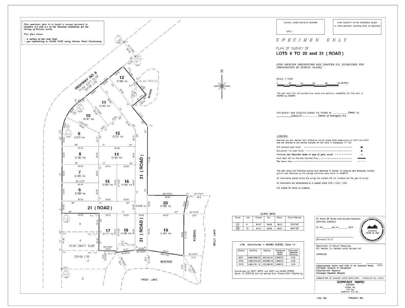
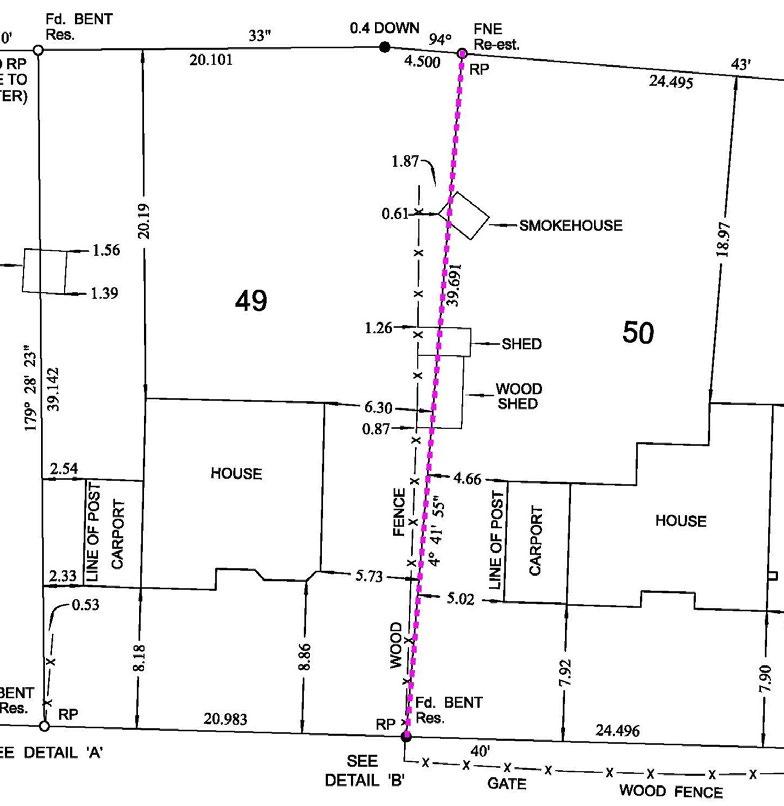
The pink-dashed line shows the boundary line between lots 49 and 50.
Where a textual description2 is to be prepared for the transaction,1 a First Nation should be aware that the textual description:
a. will not appear graphically on the ILRS e-RIP or on any of SGB’s mapping, survey records or databases9 (e.g., Google Earth overlay, CLSR, map browser, etc.) as there is no survey plan used to represent the area described.
b. should be prepared by someone who has experience in preparing and understanding these types of descriptions (i.e., prepared in such a manner that would enable a CLS to locate it on the ground and where it can only be interpreted one way).
c. can be prepared by: (I) written text only (commonly referred to as a “metes and bounds description”) – meaning there is no visual depiction/sketch of the lands dealt with, as the description is only referencing directions, distances or geographic coordinates using written text only; (ii) graphically—meaning there is only a sketch of the lands dealt with, showing distances and other references that would assist in locating it on the ground; or (iii) a combination of both text and graphical references;
The First Nation may also contact the Regional Surveyor General Branch office9 or a CLS to assist in reviewing the textual description and its intended use.
d. may not be based on field work or measurements and, therefore, the accuracy of its location may vary (depending on the reliability and accuracy of the information that is available);
e. is not recorded in the CLSR8 and, therefore, does not require survey instructions5 or formal written approval.6
f. does not split or subdivide the underlying lot. As a textual description is for a temporary interest, the existing lot or lands underlying the area described by the textual description remain whole.
Where a new survey plan is required, the First Nation will identify the survey project scope of work and prepare/obtain the required documents (sketch, Land Status Report, etc.).3
Where is has been determined that a new survey plan is to be prepared for the transaction,1 the First Nation will need to determine the full scope of the project, prepare a sketch and determine the current interests in the land being surveyed.3
The CLS will need clear direction as to what the survey project is for, what the proposed transaction will be, expected timelines, etc. Preparing a survey project scope of work3 (SOW) or setting out the project requirements in writing, will add clarity to the expectations of the First Nation and the CLS, will reduce the potential for miscommunication between the parties, minimize additional project costs and potentially avoid delays in the final project deliverables. Some potential considerations for the SOW may be:
• The timing of the field work may be impacted by many factors, which can include environmental, cultural, or site-specific considerations. When the First Nation is establishing their SOW, these considerations may affect the overall survey project timeframe and budget.
For example:
Environmental considerations: these may include when the site can be safely accessed, current water levels (e.g., a natural boundary survey may require the ability to take measurements at a natural/ordinary water level as opposed to higher levels in the spring), the season and/or weather (e.g. the time needed to locate and place monuments could be impacted by ice and snow), density or vegetation growth (e.g. the ability to use certain survey equipment can be impacted by tall or dense vegetation).
Cultural or site-specific considerations: these may include special or accompanied access to the survey area, or the limiting of access during certain times of the day or season (e.g., due to the sensitive nature of the site).
• Where a First Nation may require certain work or activities to be conducted, which are in addition to or outside of the scope of the National Standards,9 they should ensure that these are described in the SOW.3 For example, expected project communication (e.g., attending Chief and Council meetings to explain the survey), potential hiring of First Nation members to accompany the field crew, boundary line cutting (where not required under the National Standards), etc.
The First Nation will need to have a sketch3 prepared that clearly outlines the area to be surveyed and relates the new lot boundaries to existing surveys or roads in the area. Where applicable, approximate measurements and other details should be included on the sketch, such as centring the house in the lot, use the existing fence lines for the new lot boundaries, or each lot is to be 0.5 acres, etc. An existing survey plan or imagery (i.e., Canada Lands overlay in Google Earth9) could be used as the base from which to create the sketch. Where a First Nation has the CLS prepare the sketch, it is recommended that the First Nation reviews and confirms the information shown on the sketch.
Note:
For additional information or assistance in conducting a review of the interests and internal documents, a First Nation may request assistance from the Regional ISC office9 or the National and/or Regional Land Managers Association.9
We recommend that the First Nation conduct a thorough review of their internal documents/records3 (i.e., unregistered interests) and those registered documents within the ILRS9 to confirm the existing interests in the land to be surveyed, as the CLS will need to be aware of these for the survey project. While the CLS should also conduct their own search of the ILRS, the CLS does not have access to the unregistered interests that would be stored within the First Nation’s own internal records. Most Regional ISC offices can provide assistance in the preparation of the Land Status Report for the lands affected by the survey project. A written listing of interests (e.g., Land Status Report) should be provided to the CLS(s) in preparation of their cost.
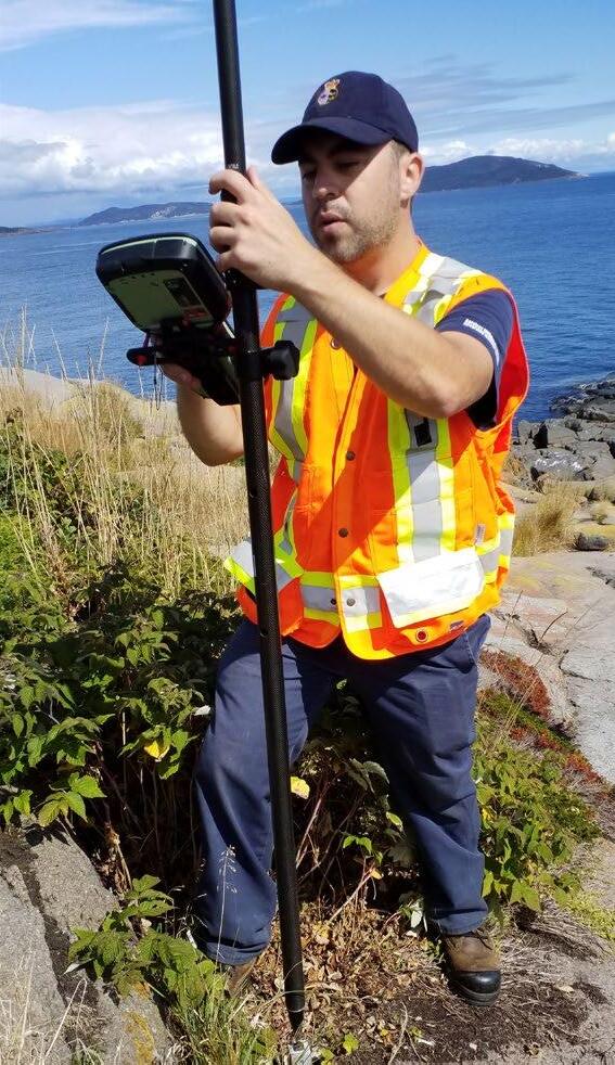
The First Nation will contact the Canada Lands Surveyor(s)4 to discuss the survey project and obtain a cost.
Only an individual who is licenced by the Association of Canada Lands Surveyors4 as a Canada Lands Surveyor (CLS) would be legally able to conduct a land survey on a First Nation’s reserve lands, also known as Canada Lands.4
The Association of Canada Lands Surveyors website9 provides additional information on the Association and how to find a CLS in your area.
https://clss.nrcan-rncan.gc.ca/data-donnees/sgb-maps-dag-carte/terre-canada-land/terre-canada-land_letter. pdf?_gl=1*1l0hpzr*_ga*NzE1OTg2MjgxLjE2NzQ1OTc1NDA.*_ga_C2N57Y7DX5*MTY3NDU5NzU0MC4xLjEuMTY3NDU5NzU5Mi4wLjAuMA
Where a survey project includes surveying on a boundary that is common with another jurisdiction (i.e., a province), such as for a survey of the exterior boundary(s) of a reserve, the CLS will also need to be commissioned or licenced as a surveyor within that province. Or the CLS would need to have another surveyor commissioned or licenced within that province to also sign the survey plan. For example, a survey of an exterior boundary for a reserve in Saskatchewan, would require the plan to be signed by a CLS and a Saskatchewan Land Surveyor (SLS).
A First Nation may use the ACLS website4 to locate a CLS in the area and then discuss with the CLS (where required) if an additional provincial commission or licence is necessary for the project and if the CLS were able to conduct the survey being requested. In many cases, the CLS would have the additional provincial commission or licence for the survey project.
Each First Nation can determine if they want to contact more than one CLS to provide them with a cost. A First Nation that has developed a strong working relationship with a CLS may choose to request a cost from that specific CLS only.
Where a First Nation decides to request a cost from more than one CLS, it is recommended that each CLS be provided with the exact same information (i.e., written project scope, sketch, Land Status Report, etc.). A true evaluation of the cost can then be conducted as all costs submitted would have been prepared using the same information.
The Association of Canada Lands Surveyors9 has prepared a brochure on the Project Scope, Planning and Research aspects of the survey process that provides potential ways to mitigate costs and other considerations for this part of the process.

Project initiation, preliminary planning and research for performing a legal survey on First Nation Reserve Lands generally follow a series of steps to effectively conduct the survey. These steps include:

• Initial discussion with client (usually the Land Manager)
• Review of the site in person and/or with online tools and aerial photography
• Research all land interests
• Research any previous and/or adjoining surveys
• Determine an estimate of costs
• Prepare a sketch of the proposed survey
• Obtain approvals from the applicable First Nation representative (usually the Land Manager) and any other stakeholders
• Submit the sketch, approvals, and land status documents to the Surveyor General Branch (SGB)1 to obtain Survey Instructions
http://www.nrcan.gc.ca/sites/www.nrcan.gc.ca/files/earthsciences/files/pdf/geomatics/Getting_a_Survey_Done_eng.pdf
Throughout the process, many cost driving factors may come into play that can cause the cost of a survey to escalate. The following cost drivers should be reviewed with the surveyor to provide the First Nation (i.e. Land Manager) with ways to maintain or potentially reduce the budget for the survey and overall project.
EThe First Nation will hire the Canada Lands Surveyor (CLS), confirm the survey project scope of work, and provide written permission3 for the CLS to access the reserve for the survey.
Where a First Nation has opted to contact more than one CLS to provide a cost, a thorough review of the costs will be required to determine who will be selected for the survey project. While the overall project cost may be the main factor in selecting the CLS, we also recommend that a First Nation ensures the contents of any cost they receive from a CLS accounts for the full scope of work, project returns, and timeframes as requested in the SOW.3 Where a First Nation is uncertain about a specific part or concept of the cost, it is recommended that they contact the CLS to obtain clarification prior to awarding the project. It is recommended that the First Nation request any additional clarification in writing. This provides a record of the supplemental information/correspondence that is in addition to the original cost.

Once the First Nation has confirmed which CLS will be hired for the survey project, they should consider having a written agreement or contract that references or outlines the project expectations. Depending on the total cost of the project and prior experience in working with the CLS, the First Nation may require the services of a lawyer to assist in preparing the written agreement. The written agreement may include the SOW3 and any additional clarification or correspondence between the First Nation and CLS with regards to the project cost, payment milestones, contact information, etc. In some instances, a survey company may provide their own agreement for the First Nation to sign.
Where an issue arises between any of the parties, the written agreement may be relied upon when attempting to determine if the determined project expectations have been met or to clarify any misunderstandings.
Where an issue or issues are identified with a project that cannot be easily resolved between the parties, the ACLS4 may be contacted to assist in reaching a resolution. Where necessary, the ACLS’ complaints process may be used to file a formal complaint.
The CLS requires written permission3 to access the reserve for the survey before they can proceed with requesting survey instructions5 from the Surveyor General Branch. If a First Nation is seeking multiple costs, they may want to wait to provide the written permission until the CLS has been selected. A First Nation’s policies may indicate who has the authority to provide the written permission3 and the format that it is to take (i.e., e-mail, letter, or Band Council Resolution). In the absence of any applicable policies, the permission may take a format determined by the First Nation and can be in any written format of an e-mail, letter, or Band Council Resolution (BCR). As a minimum, it is recommended that the permission includes:
a. the date of the permission
b. the name of the surveyor receiving permission
c. the name of the reserve that is to be accessed
d. the name(s) and title(s) of the person(s) providing the permission on behalf of the First Nation
AThe CLS will submit the sketch and written permission to the Surveyor General Branch (SGB) and request survey instructions5 to be issued for the survey project.
As required under section 24(2) of the Canada Lands Surveys Act, a CLS that will be conducting a survey and/ or preparing a survey plan on First Nation lands will need to request survey instructions5 from the Regional SGB offices9 on behalf of the Surveyor General of Canada Lands.
A Surveyor General Branch project number—this number is used for tracking the project within their various online systems.
The name of the surveyor to whom the instructions are issued.
A brief description of the survey project and the lot numbers or designators assigned.
The name of the reserve and the province.
The type of survey plan to be prepared.
Any specifics in relation to the survey project (e.g., research, monumentation required, First Nation contact information)
The CLS will complete a request through an online system called My Canada Lands Survey System (MyCLSS).9 The request will identify the type of survey to be carried out, the number of lots to be created (if applicable), together with a copy of the written permission and the sketch. Within two business days of receiving a completed MyCLSS request, the applicable Regional SGB office9 will issue survey instructions5 to the CLS.
Generally, the survey instructions will include the following type of information:
Refer to page 10 for an overview of Part 2
Usually, the survey instructions5 are brief in nature and do not repeat the requirements already contained within the National Standards or other Interdepartmental or Intergovernmental Agreements.9
It is recommended that the First Nation request a copy of the survey instructions5 to confirm the information (e.g., type of survey plan, number of lots, name of reserve, etc.). If there are any questions or concerns regarding the survey instructions, the First Nation may consult the CLS and/or the Regional SGB office.9
BThe CLS will correspond with the First Nation to confirm the timeframe for the field work and any changes to the survey project scope of work and any specific site considerations (i.e., access, safety, etc.)
The CLS should be in contact with the First Nation prior to the start of the field work, confirming the survey work is still able to proceed according to schedule or if there is a timeline or project revision required.
Once the survey instructions are issued5 and there are subsequent changes to the project requirements, the First Nation should consult with the CLS to discuss the impacts of these changes. In some situations, the number of lots to be surveyed may need to be increased or decreased, the size and/or shape of the lots may need to be reconfigured, or the timeframe for the survey may need to be changed or delayed (i.e., due to weather, safety concerns, etc.). Some of these changes may require an amendment to the survey instructions.
Any adjustments to the timing of the field work may also impact the timeframe for the submission of the survey plan and other project deliverables. Where one of the project timeframes is to be amended, the impact on the remaining project timeframes should also be reviewed for resultant changes.
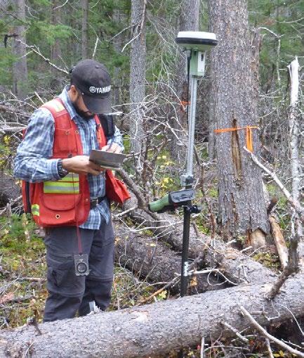
The CLS or field crew may meet with the First Nation, adjoining interest holders or other parties, as required. The field work will conclude with the required measurements being made, the survey monuments being placed, found, flagged, etc. in accordance with the survey instructions and survey project scope of work.3
The CLS may not be personally on site where a survey project could be less complex in nature (e.g., a new lot being surveyed with no identified issues) or where the project may not require the CLS to attend in person to evaluate the evidence in the field (e.g., all previously established boundaries are evident). Instead, the CLS may be represented by their field crew. The field crew would receive their direction from the CLS for the survey project and would be in direct communication in case potential issues or questions arise. The field crew may gather and document evidence, find and place survey monuments, but they are unable to evaluate the boundary and provide an opinion on the survey evidence, only the CLS is able to carry out this role. In such cases, the CLS may be called to the field to assist the field crew.
In addition, there may be situations where meetings are required to review the survey evidence, discuss the location of the boundaries, etc. Depending on the complexity of the issues or questions, the field crew may not be able to fully address the questions and the CLS may be called upon.
The work to be conducted for the survey project will depend on the survey project requirements as per the SOW,3 the survey instructions,5 and the National Standards.9 Within the National Standards, some procedures are optional, therefore, the SOW would need to confirm if they are to be included as part of the work. For example:
Where survey monuments placed during previous surveys cannot be located during this survey, should they be replaced?
Where a boundary investigation or field notes are being prepared, the replacing of survey monuments is not a requirement under the National Standards.9 Where a First Nation wanted these (not located) monuments replaced, it would need to be clearly identified in the SOW.3
What type of ancillary monumentation is to accompany the newly placed survey monuments? And should ancillary monuments accompany the existing (found) survey monuments located during the survey?
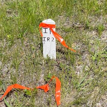
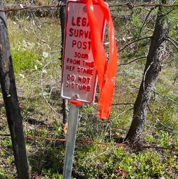
An ancillary monument is a supplemental device or marker (e.g., a wood lath, guard stake, reference post, pit, stone mound, bearing tree, etc.) that is placed near a survey monument to assist in locating the monument in the future and to protect it from destruction. The National Standards9 do not require ancillary monuments to be placed beside the existing (found) survey monuments, however, ancillary monuments are required to accompany each placed survey monument, provided that their placement does not pose a safety hazard to people or vehicles. The type of ancillary monument placed during a survey can vary from a wooden stake to metal reference posts depending on the request of the First Nation and the region where the First Nation is located.
Where a First Nation may find it to be beneficial to have ancillary monuments placed beside those existing (found) survey monuments during the survey, the First Nation should identify this as a requirement in the SOW 3
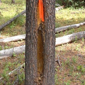
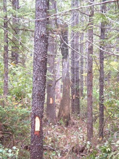
Are all boundary lines to be cut out or marked on the ground?
Boundary lines may be clearly marked or visible through line cutting, tree blazing, placement of line markers or flagging. While it may be preferable to have boundary lines cut or trees blazed, consideration must be given to environmental effects and economic factors (e.g., increase in the survey project cost). A First Nation should confirm in their SOW,3 or through discussions with the CLS, as to whether the boundary lines are to be marked and the preferred marking method.
The Association of Canada Lands Surveyors9 has prepared a brochure on the field work aspects of the survey process that provides potential ways to mitigate costs and other considerations for this part of the process.
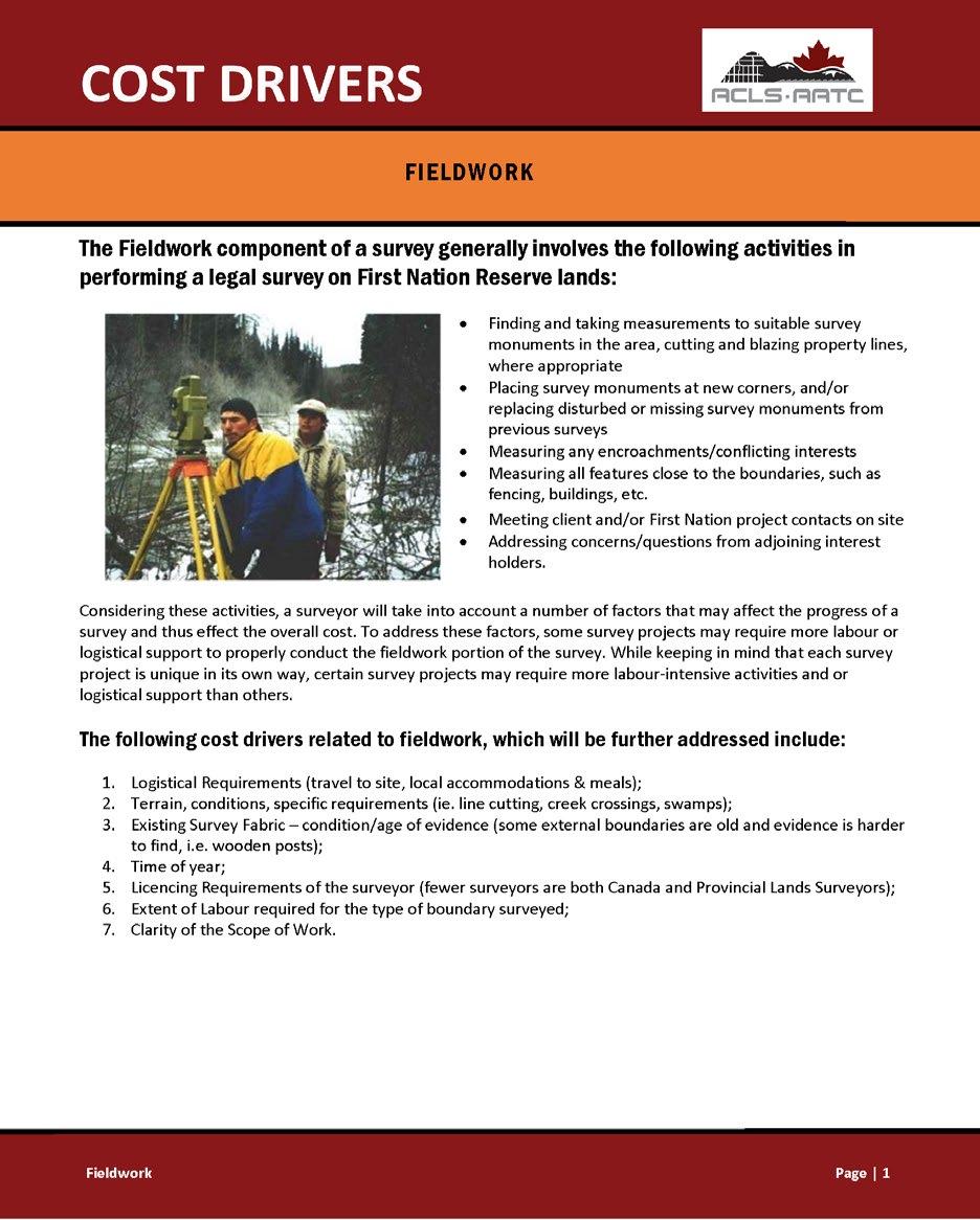
The Fieldwork component of a survey generally involves the following activities in performing a legal survey on First Nation Reserve lands:
• Finding and taking measurements to suitable survey monuments in the area, cutting and blazin g property lines, where appropriate
• Placing survey monum e nts at n ew corners and/or replacin g d isturbed or missin g survey monuments from p r ev ious surveys
• Measurin g any enc r oachments/conflicting interests
• Measuring all features close to the boundaries such as fencing, bu i ld ngs, etc.
• M ee ting client and/or First Nation project contacts on site
• Addressing concerns/questions from adjoining interest ho lders,
Considering th ese acti vities, a surveyo r w ill take into account a numbe r of factors that may affect the progr ess of a survey and thus effect the overall cost. To address these factors, some surv ey projects m ay require more labo ur or logistical support to properly conduct the fie ldwork portion of the survey. While keeping in mind that eac h survey project is unique in its own way ce rtain survey projects may require more labou r -i ntensive activities and or logistica l suppo r t than othe r s.
The following cost drivers related to fieldwork , which will be further addressed include:
1. Logistica Requirements (trave to site, loca acco mmodations & meals);
2. Terrain, co ndit ions, specific requi r ements (ie. l ine cutting, c reek crossi ngs, swa mps) ;
3. Existing Survey Fabri c-co ndition/age of evidence (some externa l boundari es are old and evidence is harder to fi n d, i.e. wooden posts);
4. Time of year;
5 Li ce ncing Requirements of the su r veyor (fewe r surveyors are both Canada and Prov i ncia l Lands Surveyors);
6. Extent of Labour r eq uired for the typ e o f boundary surveyed ;
7. Clarity of th e Scope of Work.
https://www.acls-aatc.ca/wp-content/uploads/2019/07/ACLS-Cost-Drivers_Field-Work.pdf
AThe data collected from the field work will be reviewed and analyzed in the office. Various calculations and checks will be made with the data prior to the drafting of the survey plan.

All data collected during the field work from the instruments, notes from the field crew, photographs, discussions with affected parties, etc. will be reviewed and analyzed. The CLS will be involved in evaluating the information and providing their opinion regarding the location of the boundaries depicted by the survey plan.
Various calculations will be performed to ensure the fieldwork measurements meet or exceed the accuracies required by the National Standards.9 Once the calculations are completed and the required accuracies are confirmed, the survey plan can be drafted. Where accuracies are not met, additional field work may be required. Where a CLS or field crew needs to conduct additional field work, they should contact the First Nation to advise them of the additional work and potential impacts on the survey project timeline. The CLS may be consulted throughout the drafting of the plan to ensure that the boundaries are being correctly depicted on the survey plan.
BThe survey plan is to be prepared in accordance with the National Standards for the Survey of Canada Lands9 (National Standards). The CLS will conduct a quality control check and review of the drafted survey plan.
The CLS will need to review the survey plan to ensure that it meets the SOW3 requirements, Survey Instructions5 and National Standards.9 Each survey company or CLS may have their own templates or preference as to how and where certain elements of the plan are shown. A choice of font style, location of information or preference of symbols or linework may vary, but in general the survey plans will contain the same basic information.
The Association of Canada Lands Surveyors9 has prepared a brochure on the Plan Preparation and Office Work aspects of the survey process that provides potential ways to mitigate costs and other considerations for this part of the process.
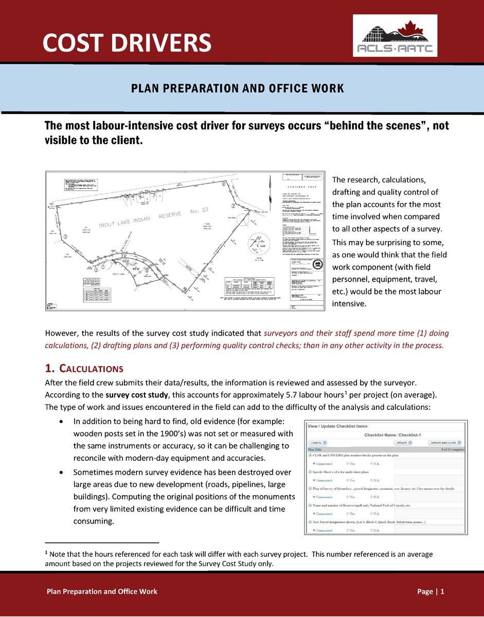
The most labour-intensive cost driver for surveys occurs " behind the scenes" , not visible to the client.
The research, ca lcu lations, drafting and qua lity contro l of the plan accounts for the most time involved when compared to all other aspects of a survey This may be surp ri sing to some, as one wou ld think that the field work component (with fie ld personnel, equipment, travel , et c. ) wou ld be th e most labour intensive.
However, the results of the survey cost study i ndicated that surveyors ond their staff spend more time (1) doing calculations, (2) drafting plans and (3) performing quality control checks; than in any other activity in the process.
After the field crew submits thei r data/results, the information is reviewed and assessed by the surveyo r According to the su rv ey cost study this accounts for approximately 5.7 labour hours 1 pe r project (on average). The type of work and issues encountered in the field can add to the difficulty of the analysis and calculat ions:
• In addition to being hard to find o ld evi dence (for example: wooden posts set in the 1900's) was not set or measured with the same instruments or accu r acy, so it can be challenging to reconcile with modern -day eq uipment and accuracies.
• Sometimes modern survey evidence has been destroyed over large areas due to new development (road s, pipeline s, large buildings). Computing the or igin al positions of the monuments from very limited existing evidence can be difficult and time consuming.
https://www.acls-aatc.ca/wp-content/uploads/2019/07/ACLS-Cost-Drivers_Plan-Preparation-and-Office-Work.pdf
COnce the CLS is satisfied the drafted survey plan meets the requirements of the National Standards,9 survey instructions5 and First Nation’s survey project scope of work,3 it will be signed and sent to the First Nation for their review and approval.6
Each CLS may have their own process as to when a survey plan is discussed with a First Nation. In some instances, a CLS may want to ensure that the survey plan accurately reflects the request of the First Nation prior to signing the plan and requesting the First Nation’s written approval of the plan. While another CLS may sign the plan and then discuss the plan with the First Nation and request their approval.
Whenever a CLS requests written approval for a survey plan from a First Nation,6 the plan being considered for approval should be the signed version of the plan.
A signed survey plan consists of the CLS’s certification and signature, whether the signature is handwritten (in ink) or in a digital format.
Sec1io,, 38, Canada Land s Surveyors Regulations CERTIFIED CORRECT
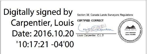
Date: 2016.10.20 '10: 17:21 -04'00
LoCJis Carpentier, C L S
When the CLS signs or certifies the survey plan, it is done according to section 38 of the Canada Lands Surveyors Regulations. 9 Section 38 is the statement of professional responsibility that the CLS takes for the plan:
38 (1) A statement of responsibility shall be in the form “certified correct”, if the survey and all associated work, documents and drawings to which the statement applies (a) were made by or under the direct supervision of that member; (b) were made in accordance with the instructions, requirements and standards applicable to the purposes for which they were made; (c) were made in accordance with the instructions of the client; and (d) are correct and true to the best of the member’s knowledge and belief.
As the CLS’ signature on the plan is confirmation that they have directly supervised the project, the project was conducted according to the standards9 and requirements5 and per the request3 of the First Nation and that it is correct and true to the best of their knowledge, it is recommended that only signed plans be considered for review and approval by a First Nation.
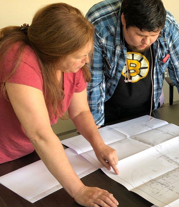
Upon receiving the signed survey plan, the First Nation will need to review it and, once satisfied it meets their requirements, provide written approval6 of the survey plan to the CLS.
A First Nation can determine the factors or items they will review on the plan, to ensure that it meets the survey project requirements stated in the SOW, written agreement, and survey instructions.6
Some items for consideration by the First Nation when reviewing the plan may include:
• Ensuring the plan shows the extent of survey work, in the correct location and configuration for the work as per the SOW3 and meets any applicable planning/land use requirements and/or policies. For example, if the First Nation had requested an existing lot be subdivided into five smaller lots, does the survey plan correctly reflect the configuration and number of lots requested in the SOW?3
• Ensuring the reserve name, road names, etc. are correct.
• Comparing the survey plan prepared to the survey instructions,5 in regard to the type of survey plan prepared, the title of the plan and the surveyor signing the plan is the person with whom the instructions were issued to.
Where a First Nation may have questions or concerns related to the plan, they should request clarification from the CLS before written approval is provided.

Once the First Nation is satisfied the survey plan meets their expectations, written approval6 will be required. A First Nation’s policies may indicate who has the authority to provide the written approval and the format that it is to take (i.e., e-mail, letter, or Band Council Resolution). In the absence of any applicable policies, the approval may take a format determined by the First Nation, and can be in any format of an e-mail, letter, or Band Council Resolution (BCR).
As a minimum, it is recommended that the approval includes:
a. the date of the approval
b. the name(s) and title(s) of the person providing the approval on behalf of the First Nation
c. the title of the survey plan
d. the name of the CLS
e. the date the CLS signed the survey plan.
A copy of the written approval will need to be sent to the CLS in order for them to submit the plan to the SGB for further processing.
The CLS will submit the survey plan, written approval and any other required documents to the Surveyor General Branch for their review7 and recording of the plan.
The CLS will submit the signed survey plan and copy of the written approval through the MyCLSS website.9
The SGB will be notified of the submission of the survey plan and it will be put in the queue for their review. Once the review of the survey plan has been initiated by the SGB, the information in the SGB Project Search website7 will be updated.
It is the responsibility of the SGB to ensure that the survey plan meets the requirements of the National Standards9 and the survey instructions.5 The plan review performed by the SGB does not ensure the requirements of the agreement between the First Nation and CLS are met, rather the SGB review is in relation to the requirements of the National Standards,9 applicable Legislation,9 and the survey instructions.5

The CLS will be notified through MyCLSS9 of any major error (or may also be termed a “critical error”) identified during the SGB review.
A critical error may include (but not limited to):
• changes to the plan title block
• changes to the size or shape of the parcel(s)
• where additional field work is required.
The CLS will need to review the information from MyCLSS and where necessary, complete any amendments and re-sign the survey plan.
The CLS is required to obtain a First Nation’s re-approval9 of the plan where any amendments are made to the survey plan due to a critical error (as described above).
Once the survey plan is deemed to meet the requirements of the National Standards,9 and all required approvals7 and documents have been provided, the survey plan is recommended for approval/confirmation.
Most Administrative (Section 31) types of survey plans prepared only require the First Nation’s written approval for the plan to be processed and recorded in the CLSR. An Official (Section 29) type of survey plan would require the First Nation’s written approval, in addition to the Regional Indigenous Services Canada (ISC) office and possibly the province (where there is a jurisdictional boundary surveyed on the plan).
Where a survey plan requires additional approvals, the SGB will contact the Regional ISC office and/or the province to request those approvals. Once all of the required approvals have been received, the survey plan will be signed by the SGB. The Surveyor General Branch Project Search website7 will show the status of the requested approvals.
Once all approvals are received and the SGB has confirmed the plan meets the requirements of the National Standards,9 applicable legislation,9 and the survey instructions,5 the survey plan will be recommended for signing by the Surveyor General or their designate.
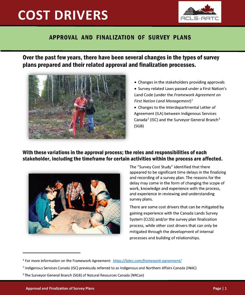
The Association of Canada Lands Surveyors9 has prepared a brochure on the Approval and Finalization of Survey Plans aspect of the survey process that provides potential ways to mitigate costs and other considerations for this final part of the process.
https://www.acls-aatc.ca/wp-content/uploads/2019/07/ACLS-CostDrivers_Approvals-Registration.pdf
tha t there appeared to be significant time delay s in the final i zing and recording of a su rvey pla n . The r easons for the delay may come in th e form of chang ng the scope of work, kn owledge an d experience with the proce ss, and exper ence in reviewing and understanding survey p lans. There are some cost drive r s that can be mitigated by gaining expe ri ence with the Canada Lands Su rvey System (CLSS) and/or the survey plan finalization process while oth er cost drive r s that can only be mitigat ed through the development of internal processes and bu ilding of rel at ionships
1 For more information on the Framework Agreement : https:/labrc .com/framework-agreement/
2 Indigenous Services Ca nada (ISC) previous y refer red to as Indigenous and Northern Affairs Canada (INAC)
3 The Surveyor General Branch (SGB} of Natural Resources Canada (NRCan) Approval and Anahzalton of Survey Plans
The survey plan is approved/confirmed by an authorized representative of the Surveyor General Branch and recorded in the Canada Lands Surveys Records (CLSR).8 The digital image of the survey plan is made available to the public.
Once the survey plan has been signed by the Surveyor General or their designate, the plan will be sent for recording in the CLSR. The SGB Project Search website7 will be updated with the assigned CLSR plan number. The digital image of the survey plan is available for download through the SGB Project Search website7 or Plan Search website8 within a few days of receiving the CLSR number.
The SGB’s digital data sets9 will be updated within approximately 3 weeks of receiving the CLSR number.

As per Section 30 of the Canada Lands Surveys Act, Official (Section 29) types of survey plans of exterior boundaries will also be sent for filing with the applicable provincial or territorial land title or registry office. The filing of this plan in the applicable provincial or territorial land title/registry office assists to ensure that anyone conducting surveys on lands adjoining Canada Lands has access to the information.
The provincial or territorial land title/registry number will be added as indexing information to the plan information within the SGB Plan Search website8 when it becomes available.
Where a document is to be registered in the ILRS, the lot number(s) and CLSR plan number can now be referenced in the document. The First Nation may work with the Regional ISC office to have the document registered in the ILRS.
While this document provides an extensive amount of information on the survey process, there may be additional questions or concerns that have not been addressed by this document. If additional assistance is required, a First Nation may contact:
• the applicable Regional Surveyor General Branch office (https://www.nrcan.gc.ca/maps-tools-and-publications/ maps/canada-lands-surveys/about-canada-lands/10855)
• the National and/or Regional Land Managers Association (https://nalma.ca/)
• the local CLS
for determining the type of survey plan or land description required for a transaction..
The intent of the proposed transaction to be registered in the ILRS, and in some cases the length of time or term of the transaction, will assist in identifying the minimum requirement of the type of survey plan or land description that is necessary. The Interdepartmental Letter of Agreement Related to the Cooperation in the Area of Surveys and the Specifications for Descriptions of Land for Transactions on Reserve Lands, 2014 (ILA)9 applies to surveys conducted on lands managed under the Indian Act
The column on the left within Chart “A,” titled “Land Transaction Purpose” contains five main headings for the types of transactions and the corresponding column on the right lists the minimum type of survey plan required for that transaction
I – Additions to Reserve
II – Band vote for designation
III – Disposition of Reserve
IV – Exclusive use
V – Non-exclusive use
A First Nation will need to identify the purpose and term of their proposed transaction in the “Land Transaction Purpose” column to determine the type of survey plan or land description required. Once the determination has been made, it is recommended that the First Nation confirms that there is no existing survey plan (recorded in the CLSR) or land description that could be used for the proposed transaction.
As a minimum, any lands that are added to a First Nation’s land base, outside of the territories, will require a provincial survey plan; for lands within the territories, the requirement is a survey plan prepared under the National Standards (filed in the appropriate land titles office). For those lands outside of the territories, a provincial survey plan to be prepared as the lands would still be considered as provincial lands (not Canada Lands) until the transfer is complete to Canada through a Ministerial Order. The provincial lands would be surveyed by a land surveyor licenced within that particular province, with the survey plan being filed in the applicable provincial land title/registry office. A copy of the filed provincial survey plan would then be recorded in the CLSR. The provincial plan will have a different appearance (i.e., title block, approvals, etc.) from that of survey plans prepared under the National Standards. However, once a copy of the provincial plan is recorded in the CLSR, it is viewed to be comparable to that of a survey plan prepared under the National Standards. Once the provincial plan is recorded in the CLSR, it may be used for subsequent transactions in the ILRS where the provincial plan is of a similar standard to a survey plan that would be prepared under the National Standards.9 For example, where the provincial plan (now recorded in the CLSR) is considered to be fully surveyed (i.e. survey
monuments are located in all corners of the parcel), it would be equivalent to a “Plan of Survey (Administrative Plan)” and could be used for those transactions listed in Chart “A,” where the “Plan of Survey (Administrative Plan)” is shown in the right side column, provided that the survey plan reflects all of those lands to be dealt with in the transaction.
As a minimum, where there is to be a vote on designating a First Nation’s interests in a portion of or all of their Reserve land, an Explanatory Plan (Administrative Plan) is required [https://clss.nrcan-rncan.gc.ca/clss/ surveystandards-normesdarpentage/dl?p=12B_Explanatory_Plan_of_ Parcel_Sep2014.pdf&type=spec]. When there is to be an interest issued on the designated lands (i.e., a lease), the purpose of that new transaction will need to be related to the “Land Transaction Purpose” column in Chart “A” and a new type of survey plan or land description will likely be required.
(a) Surrender of Parcel – the term surrender in Chart “A” is understood to be an absolute surrender as per subsection 38(1) of the Indian Act. Therefore, a “Plan of Survey (Official Plan)” is required for the parcel that will be transferred from the reserve. An official plan would be prepared, as a jurisdictional boundary would be created upon the land being transferred from the reserve. This type of plan is also referred to as a “Section 29 Plan” (referencing Section 29 of the Canada Lands Surveys Act9) or a “Jurisdictional Boundary Survey Plan” in Section 2.3 of the National Standards.9
(b) Highway/Right of Way Transfer – the term transfer in Chart “A” is understood to be an absolute surrender as per subsection 38(1) of the Indian Act. Therefore, a “Plan of Survey (Official Plan)” is required to depict those lands required for the highway/right of way parcel(s), that will be transferred from the reserve [https://clss.nrcan-rncan.gc.ca/clss/ surveystandards-normesdarpentage/dl?p=8_Plan_of_Survey_of_Highway_ Widening_Sep2014.pdf&type=spec]. An official plan would be prepared, as a jurisdictional boundary would be created upon the land being transferred from the reserve. If lands are to be exchanged with another party (i.e., those reserve lands are to be transferred to the province, in exchange for provincial lands to be added to the reserve), those lands that are intended to be added to the reserve will be surveyed as per the process described in I – Additions to Reserve above.
As a minimum, the following types of transactions will require a “Plan of Survey (Administrative Plan).” This type of plan is also referred to as an “Administrative Plan,” a “Section 31 Plan” (referencing Section 31 of the Canada Lands Surveys Act9), or a “Parcel Survey Plan” in Section 2.4 of the National Standards9 [https://clss.nrcan-rncan.gc.ca/clss/surveystandardsnormesdarpentage/dl?p=4_Plan_of_Survey_of_Parcel_and_Road_ Sep2014.pdf&type=spec].
A textually described parcel does not appear on the SGB mapping (Google Earth overlay, Map Browser) and is not recorded in the CLSR. The textually described parcel is also not depicted on the ISC E-RIP, which may create complexities when trying to determine the location and existing interests in the land.
The term “lease” may include a head lease or sublease.
• allotment of land – e.g., lawful possession, transfers, community purposes
• lease of land for longer than 10 years
As a minimum, the lease of land for 10 years or less will require a textual description if the registry feels it is in the best interests of the First Nation, to do so, given the circumstances. However, in most cases an Explanatory Plan (in Section 2.8 of the National Standards9 [https://clss.nrcan-rncan. gc.ca/clss/surveystandards-normesdarpentage/dl?p=12B_Explanatory_ Plan_of_Parcel_Sep2014.pdf&type=spec]) would be required for this type of transaction. As there currently are no standards or guidelines for the preparation of a textual description, there is no consistency in the appearance of each or guarantee that the description can be uniformly interpreted by different parties.
As a minimum, the lease of a building unit for longer than 10 years will require a “Plan of Building Unit(s) (Administrative Plan)” [https://clss.nrcanrncan.gc.ca/clss/surveystandards-normesdarpentage/dl?p=20A_Plan_of_ Survey_of_Building_Units.pdf&type=spec]. This type of plan is also referred to as a “Building Unit Survey” in Section 7.1 of the National Standards.9 Whereas the lease of a building unit for 10 years or less would require a textual description (refer to Using a Textual Description (not surveyed) on page 20 for additional information on a textual description).
The creation of an “airspace” parcel is done through a “Plan of Airspace Parcel(s) (Administrative Plan)” [https://clss.nrcan-rncan.gc.ca/clss/ surveystandards-normesdarpentage/dl?p=26_Plan_of_Survey_of_Air_ Space_Parcels_Sep2014.pdf&type=spec]. This type of plan is also referred to as an “Airspace Parcel Survey” in Section 9.1 of the National Standards.9 While not a common type of parcel created, an air space parcel defines a volume of space for such uses as an underground tunnel or parkade, bridge, overhead walkway. These types of parcels are defined by threedimensional coordinates.
Permit or licence will require a textual description if the registry feels it is in the best interests of the First Nation to do so, given the circumstances. However, in most cases an Explanatory Plan (in Section 2.8 of the National Standards9 [https://clss.nrcan-rncan.gc.ca/clss/surveystandardsnormesdarpentage/dl?p=12B_Explanatory_Plan_of_Parcel_Sep2014. pdf&type=spec]) would be required for these types of transactions.
Utility permit over unencumbered lands as a minimum will require a textual description. However, Section 2.5.2 of the National Standards9 describes those situations of where the right of-way crosses a large, not surveyed area (more than one kilometre), or if the boundaries of the right-of-way cannot easily be related to existing surveyed boundaries or monuments, a “Plan of Survey (Administrative Plan)” of the right-of-way would need to be prepared. The necessity for the “Plan of Survey” is usually reserved for those major utility lines crossing over extensive areas of unencumbered reserve lands.
Note:
While access to a parcel may be shown on a survey plan, the survey plan itself does not legally establish recognized access to the parcel. An interest (i.e., access agreement) should be registered in the ILRS where legal access is required for a parcel.
The First Nation may also contact the Regional Surveyor General Branch office,9 the CLS or the National and/or Regional Land Managers Association9 to assist in determining the minimum type of land description required and potential options available for the transaction.
In addition, there may be areas of planned future development and it will be important to know the location of the utility infrastructure (e.g., fibre-optic line, water line, sewer line, etc.). In these situations, it is recommended that there be an “Explanatory Plan (Administrative Plan)” prepared as described in Section 2.8 of the National Standards9 [https:// clss.nrcan-rncan.gc.ca/clss/surveystandards-normesdarpentage/ dl?p=12A_Explanatory_Plan_of_Utility_Right_of_Way_Sep2014. pdf&type=spec].
Utility permit over encumbered lands will require an “Explanatory Plan (Administrative Plan)” as described in Section 2.8 of the National Standards9 [https://clss.nrcan-rncan.gc.ca/clss/surveystandardsnormesdarpentage/dl?p=12A_Explanatory_Plan_of_Utility_Right_of_ Way_Sep2014.pdf&type=spec]. The preparation of an explanatory plan will assist in locating the permit area in relation to the boundaries of the parcel and help provide a clear description of the permit area that the encumbered lands may be subject to (if desired)
Access agreement (access right-of-way) over allotted or leased lands as a minimum will require a textual description. A textual description can be sufficient for a short term or an occasional access (e.g., seasonal purposes) interest. Where long-term access is to be granted, it is recommended to define the access right-of-way by an “Explanatory Plan (Administrative Plan)” or a “Plan of Survey (Administrative Plan)” [https:// clss.nrcan-rncan.gc.ca/clss/surveystandards-normesdarpentage/dl?p=6A_ Plan_of_Survey_of_Lots_and_Road_and_Right-of-Way.pdf&type=spec]. The survey plan for the right of way does not have to sever (subdivide) the underlying parcel, rather the survey plan would clearly define that portion of the existing parcel that would be subject to the right-of-way.
Agricultural permits will require a “Land Use Area Plan (Administrative Plan).” This type of plan is also referred to as “Administrative Area and Land Use Area Plans” in Section 2.9 of the National Standards.9 These types of plans are commonly prepared for agricultural permits as these interests are short term and the boundaries of the interest do not need to be defined by or referenced to surveyed boundaries. The boundaries on these plans can reference natural or man-made features, coordinates, existing plans, etc. Refer to Section 2.9.2 of the National Standards9 for the full listing of the information sources for the preparation of these types of plans.
(a) Existing survey plans: Before requesting a new survey plan to be prepared by a Canada Lands Surveyor, it is recommended that a First Nation review the existing CLSR survey plan(s) for the area to see if there is an existing and appropriate survey plan that could be used for the transaction. Where an existing survey plan can be used for the transaction, a new survey plan is not required. However, a First Nation may request to have the boundaries of the previously surveyed lot(s) clearly identified on the ground (e.g., to confirm the existence of encroachments or identify the extent of the parcel). Field notes of the survey work conducted by the CLS may be prepared, which will identify where survey monuments have been found, placed, the extent of encroachments, etc. [https://clss.nrcan-rncan.gc.ca/clss/ surveystandards-normesdarpentage/dl?p=13_Field_Notes_of_Survey_ of_Jurisdictional_Boundary_in_Plan_Form_Sep2014.pdf&type=spec]
To use an existing survey plan for a new transaction, that survey plan must meet the current plan standards and the plan must be the latest survey plan of the lot. For example: If Lot 1 was surveyed on Plan 1234
CLSR, with the entire Lot being later subdivided into Lots 1-1 and 1-2, Plan 2345
CLSR. Lot 1 Plan 1234
CLSR has been superseded (replaced) by Plan 2345
CLSR and can no longer be referenced in any new transactions.
As field notes do not create boundaries of parcels (rather, they reflect the results of the CLS’ field work), the document to be registered in the ILRS will still refer to the existing survey plan number (not the CLSR number assigned to the newly prepared field notes).
(b) Preparation of a compiled plan – a compiled plan is produced from combining information from existing* survey plans and field notes in the CLSR and/or may include information from a plan filed in the provincial or territorial land title/registry office. These types of plans have specific applications and require specific instructions from the SGB. The CLS must demonstrate the suitability of using this type of survey plan for a specific purpose. (Refer to Chapter 2.7 of the National Standards9 for the four specific uses of this type of plan [https://clss.nrcan-rncan.gc.ca/ clss/surveystandards-normesdarpentage/dl?p=10_Compiled_Plan_of_ Lots_March2020.pdf&type=spec].)
*New field work may be required to prepare this type of plan, and the field notes from the field work are to be recorded in the CLSR prior to the recording of the compiled plan, or the information may be included on the compiled plan, provided it can be depicted in a clear and organized manner. [https://clss.nrcan-rncan.gc.ca/clss/ surveystandards-normesdarpentage/dl?p=11A_Compiled_Plan_of_ Lots_and_Field_Notes_February2021%20WCAG.pdf&type=spec]
(c) Textual/graphical description – as mentioned in Using a Textual Description (not surveyed) on page 20 of this document, a textual description2 may be used as the minimum description requirement for certain transactions listed in Chart “A” of the current ILA.9 A textual description is not a survey and may use text, graphics, or a combination of both.
As there is no survey plan prepared or used to represent the area described in a textual description, there will be no graphical depiction of the interest on the ILRS e-RIP or on any of SGB’s mapping, survey records or databases9 (e.g., Google Earth overlay, CLSR, map browser, etc.). The accuracy of the location for the area described by the textual description may vary as it is dependent on the accuracy and reliability of the source information used to prepare the description.
It is strongly recommended that a textual description be prepared by a CLS, or by someone who has experience in preparing and understanding these types of descriptions (i.e., prepared in such a manner that would enable a CLS to locate it on the ground and where it can only be interpreted one way).
A textual description may be prepared in different formats:
(i) written text only (commonly referred to as a “metes and bounds description”)—meaning there is no visual depiction/sketch of the lands dealt with, as the description is only referencing directions, distances or geographic coordinates using written text only. The description will usually have a point of beginning and then textually describe the boundaries of the parcel (usually proceeding in a clockwise direction), with description closing back on the point of beginning.
For example: Beginning at the intersection of the southern boundary of Beaver Creek Indian Reserve No. 9, Plan 12345 CLSR and the east limit of an unsurveyed road (known as Valley Road), being 15 metres from the centreline of the travelled road surface; thence north and parallel with the east limit of said road a distance of 100 metres; thence east and parallel with the south limit of Beaver Creek Indian Reserve No. 9, Plan 12345 CLSR a distance of 49.5 metres; thence south and parallel with the east limit of the unsurveyed road (known as Valley Road) to the intersection with the southern boundary of Beaver Creek Indian Reserve No. 9, Plan 12345 CLSR, being an approximate distance of 100 metres; thence westerly along the southern boundary of Beaver Creek Indian Reserve No. 9, Plan 12345 CLSR at an approximate distance of 49.5 metres to the point of beginning. Containing 0.495 hectares (1.22 acres), more or less.
(ii) graphically – meaning there is only a sketch of the lands dealt with, showing distances and other references that would assist in locating it on the ground; or
(iii) a combination of both text and graphical references.
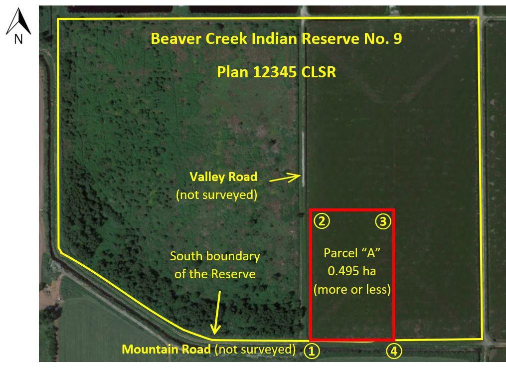
1 (intended to be coincident with the south boundary of the Reserve and the east limit of Valley Road)
2 (intended to be coincident with the east limit of Valley Road)
3
4 (intended to be coincident with the south boundary of the Reserve along Mountain Road)
UTM coordinates values in NAD83 (CSRS) EPOCH 2002.0.
Note: Where there may be a discrepancy between the coordinate value and the intended feature, the feature will override the coordinate value in the chart.
Using the example above, the textual description referenced within the document that is to be registered in the ILRS, could be:
• Parcel “A” outlined in red on the attached sketch, containing 0.495 hectares, more or less; or
• Parcel “A” outlined in red on attached Schedule “I,” containing 0.495 hectares, more or less.
o Reference to a numbered/lettered schedule is usually done for documents that have more than one attachment.
It is imperative that where additional documentation is referenced (i.e., attached sketch or Schedule “I”), that it be included with the document being registered, and colour-scanned if there is a colour referenced in the description (i.e., in this example it would be in red).
Additionally, in this example the “attached sketch” is prepared using GPS coordinates to define the corners of the parcel, overlaid on a Google Earth image. It is recommended to add as much supporting information as possible, such as road names, north arrow, etc. on the sketch to ease in the locating of the parcel. The table of coordinates lists the point number and intended feature/limit with the corresponding coordinate value and the coordinate reference datum (i.e., NAD83 (CSRS) EPOCH 2002.0). A notation is also added to indicate that in the situation where the coordinate value and intended feature do not align, the actual feature/limit will override the coordinate value.
When preparing the survey project scope of work (SOW), a First Nation may want to consider incorporating the answers to some of the following questions with their SOW:
• What is the intended transaction?
• Who will be the First Nation contact(s) for the project?
• Are there any known or potential disputes between adjoining interest holders?
• Is there concern for encroachments over the existing boundaries?
• Are there any existing policies that the CLS should be aware of for the survey? Where these policies are publicly available, reference should be provided as to where they can be accessed. Where these policies are not publicly available, the applicable sections or references should be provided.
• How will access to the survey area be obtained? And is access only during certain times? For example, is the road gated, are there certain hours that the survey crew cannot be on-site, can it be accessed by a truck, etc.?
• Where it is not already a requirement under the National Standards,9 and where applicable to the project, do you want any missing survey monuments for the lot replaced?
• Do you want the boundary lines cut out by the survey crew? Or do you want the lines to be clearly marked (i.e., with flagging, line markers, etc.) with minimal to no cutting involved?
• Do you want guard posts/marker posts placed beside all survey monuments (in those locations where not currently required under the National Standards9 and where safe to do so)? If so, what type is preferred?
• What are the expected project returns and when are they due by:
o Do you want a digital or paper version of the survey plan? If paper, how many copies do you require?
o Do you want to be shown the boundaries on the ground?
o Do you want the surveyor to attend a meeting (virtual or in-person) to discuss the plan?
Note:
The First Nation should be aware that there may be a need to include a contingency within the project budget for any unforeseen items or issues that may arise.
o Is the deadline for the plan submission fixed (the plan must be submitted by this date) or suggested (the plan should be submitted around this date)?
• Who is the party responsible for paying for the survey and what is their contact information?
• When is the cost from the Canada Lands Surveyor due by and to whom is it to be sent?
• Are you expecting the CLS to be on-site for the duration of the project or only in those situations where the CLS’ presence is required (i.e., evaluate evidence to determine the location of the boundary)?
• Canada Lands are defined in Section 24(1) of the Canada Lands Surveys Act as:
(a) any lands belonging to His Majesty in right of Canada or of which the Government of Canada has power to dispose that are situated in Yukon, the Northwest Territories or Nunavut and any lands that are
(i) surrendered lands or a reserve, as those expressions are defined in the Indian Act, other than reserve lands described in regulations made under section 4.1 of the First Nations Commercial and Industrial Development Act,
(ii) Category IA-N land, as defined in subsection 2(1) of the Naskapi and the Cree-Naskapi Commission Act,
(ii.1) Category IA land, as defined in subsection 2(2) of the Cree Nation of Eeyou Istchee Governance Agreement Act,
(iii) shíshálh lands, as defined in subsection 2(1) of the shíshálh Nation Self-Government Act,
(iv) settlement land, as defined in the Yukon First Nations Self-Government Act, and lands in which an interest is transferred or recognized under section 21 of that Act,
(v) lands in the Kanesatake Mohawk interim land base, as defined in the Kanesatake Interim Land Base Governance Act, other than the lands known as Doncaster Reserve No. 17, or
(vi) Tlicho lands, as defined in section 2 of the Mackenzie Valley Resource Management Act; and
(a.1) any lands belonging to His Majesty in right of Canada or of which the Government of Canada has power to dispose that are situated in any National Park of Canada or in the Rouge National Urban Park established by the Rouge National Urban Park Act; and
(b) any lands under water belonging to His Majesty in right of Canada or in respect of any rights in which the Government of Canada has power to dispose.
((UNITEDSTATESOFAMERICA) ÉTATSUNISD'AMÉRIQUE)
LabradorSea MerduLabrador
OCÉANATLANTIQUE
https://clss.nrcan-rncan.gc.ca/data-donnees/sgb-maps-dag-carte/terre-canada-land/terre-canada-land_letter. pdf?_gl=1*1l0hpzr*_ga*NzE1OTg2MjgxLjE2NzQ1OTc1NDA.*_ga_C2N57Y7DX5*MTY3NDU5NzU0MC4xLjEuMTY3NDU5NzU5Mi4wLjAuMA
• A Canada Lands Surveyor (CLS) is the only person who is legally authorized to conduct land surveys on Canada Lands. A CLS is an expert in property rights systems and is able to provide advice on property boundary-related matters, various types of surveys, land management and administration. Refer to: https:// www.acls-aatc.ca/what-is-a-canada-lands-surveyor-cls/ for additional information on a CLS, including the extensive education and training required to become a licenced CLS.
The Association of Canada Lands Surveyors has prepared a brochure on the Role of a Canada Lands Surveyor. It includes the responsibilities of a CLS, the Code of ethics, and how a CLS differs from a provincial land surveyor.

“No development will take place without having a spatial dimension, and no development will happen without the footprint of surveyors the land information professionals.” 1
There are 4 main components2 of a survey project for which a surveyor is responsible:
• Project initiation, Preliminary planning and Research: discussions with the client, researching land interests, estimating the project costs, etc.
• Fieldwork: locating survey evidence, placing survey monuments, taking measurements, etc.
• Plan preparation and office work: research, drafting plans, calculations, quality control
• Approvals and Finalization of a Survey Plan: the discussions, review and approval of the survey plans and reports, and the recording of these documents in the Canada Lands Survey Records (CLSR)
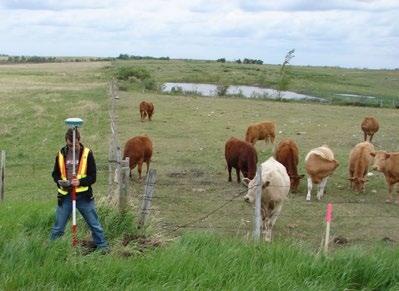
“The survey plan must be a memorial of the entire effort, an accurate reflection of the evidence which was uncovered, weighted and/or rejected, in the fact matrix which forms the opinion on the location of the boundary, akin to reasons for a judicial decision” 3
a. Client vs. Public
Although one property owner may hire the land surveyor to determine the location of the property line between one or more adjoining property owners, the land surveyor cannot favour their client. “Land surveyors are public officers. They do not represent a single client in establishing client’s boundaries but rather they represent society at large.”4 A land surveyor is to be impartial when carrying out their duties and will formulate an opinion through evaluating the evidence to determine the extent of a parcel, rather than basing it on who their client is.
1 Professional Surveyors Canada https://www.psc-gpc.ca/a-career-as-a-professional-surveyor/surveyors-and-what-we-do/
2 For a further analysis of these components and their affects on the cost of a survey, refer to: https://www.acls-aatc.ca/aboriginal-expertise/surveys-onIndiegenous-Lands-Toolkit/
3 Surveys: “They Work Great if you Know How to Use Them” presentation by Geoffrey Connolly, QC, P. Eng. and Serge Bernard, P. E
4 Association of Prince Edward Island Land Surveyors http://www.apeils.ca/
www.acls-aatc.ca/wp-content/uploads/2019/08/ACLS-Role-of-a-Surveyorfinal-draft.pdf
• The Association of Canada Lands Surveyors (ACLS) was established as a self-regulating entity to protect the interest of the public in relation to the practice of surveying on Canada Lands, in accordance with three main parts of federal legislation:
Canada Lands Surveys Act: https://laws-lois.justice.gc.ca/eng/acts/L-6/page-1.html#h-344804
Canada Lands Surveyors Act: https://laws.justice.gc.ca/eng/acts/L-5.8/page-1.html#h-344098
Canada Lands Surveyors Regulations: https://laws-lois.justice.gc.ca/eng/regulations/sor-99-142/index.html
The ACLS oversees the professional development, licencing, membership of the profession of surveying on Canada Lands, while ensuring the interest of the public is protected. The ACLS is governed through a Council elected by the membership, and has established bylaws, standards, licencing requirements, including investigation and discipline procedures for its members.
• If a First Nation does not have a CLS whom they regularly work with, they have a few ways to locate one in their area.
(a) Asking the Regional SGB office for a listing of CLS that may be contacted.
(b) Using the ACLS website: https://www.acls-aatc.ca/find-a-surveyor/
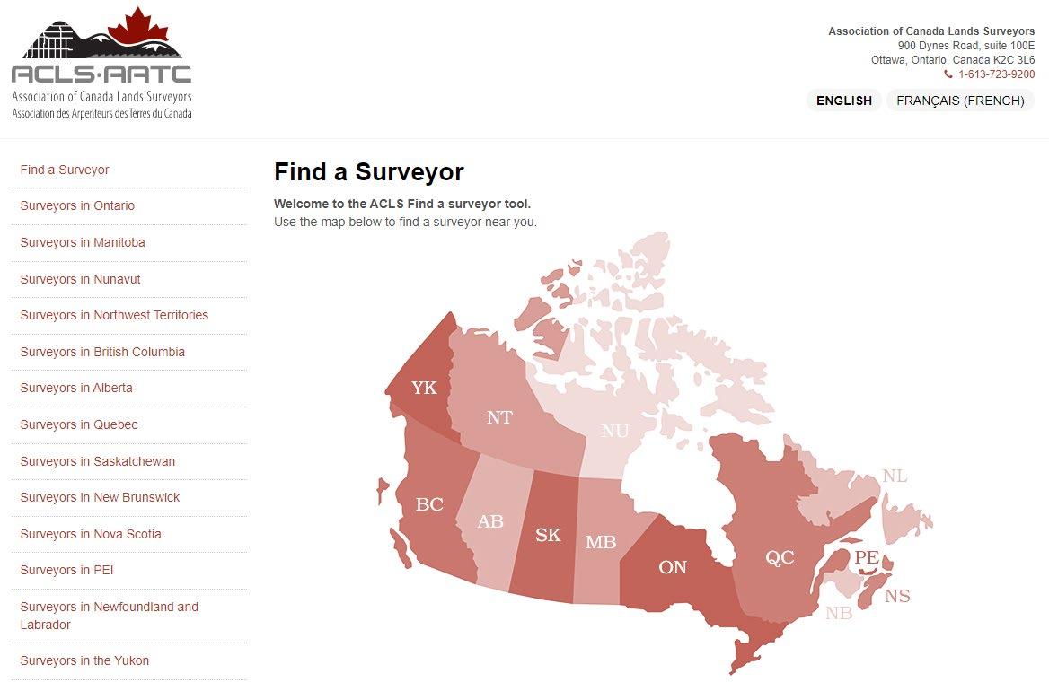
Once you select the applicable province from the listing on the left side of the page, a listing of the CLS, their associated survey company and phone number will appear.
Once a First Nation has selected a CLS, they could discuss the scope of the project and whether an additional provincial commission or licence is necessary for the project. In many cases, the CLS would have the additional provincial commission or licence for the survey project.
Under Section 24(2) of the Canada Lands Surveys Act it is stated: Surveys of Canada Lands shall be made in accordance with the instructions of the Surveyor General
It is important to also note that not all survey-related work requires survey instructions from the SGB. Those types of surveys that will not be recorded in the CLSR and where parcel boundaries have not been created, such as: topographic surveys, building layout and other construction-related surveys do not require survey instructions to be issued by the SGB.
1 Project number: A unique project number is assigned to each survey project opened by the SGB, consisting of three elements:
• The fiscal year: the example shows it was opened in the 2018-19 fiscal year.
• The region: each region is assigned a numerical number. 14 represents the province of Ontario.
• The numerical order in which the project was opened: the example shows it was the first project opened in the fiscal year.
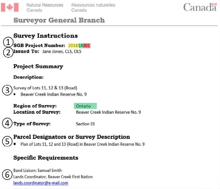
2 Issued to: The name of the surveyor to whom the instructions are issued. The example shows the instructions are issued to Jane Jones, who is a Canada Lands Surveyor (CLS) and an Ontario Land Surveyor (OLS).
3 Description: A brief description of what the survey is for and any lot numbers or designators that have been assigned. The example shows the survey is for three, being Lots 11 and 12, with Lot 13 being a road, within Beaver Creek Indian Reserve No. 9.
4 Type of survey: This references the type of survey product or plan being prepared (i.e., Section 29 plan, Section 31 plan, field notes, etc.). The example shows the survey is for a Section 31 plan.
5 Parcel Designators/Survey Description: The survey description is the proposed title of the survey plan. Where there are changes to the SOW (e.g., additional lots being added), amended survey instructions may be required to provide the new title of the plan. The example shows the title of this plan will be “Plan of Lots 11, 12 and 13 (Road) within Beaver Creek Indian Reserve No. 9.”
6 Band Liaison: The name and contact information for the liaison from the First Nation is also provided on the survey instructions. The SGB may provide the First Nation contact with a copy of the survey instructions and may need to contact them to obtain clarification regarding the survey and/or plan. The example shows the contact to be Samuel Smith.
The remaining sections of the survey instructions may provide:
• a link to the National Standards for the Survey of Canada Lands.
• specific requirements, which may highlight or waive certain requirements of the National Standards, guidance for research for the CLS.
• a reference to the SOW (provided to the CLS) or some of the applicable requirements from the SOW.
• general notes, which include who prepared the instructions and the timeframe for which the instructions are valid.
• the SGB project contact.
The survey instructions will not instruct or limit the CLS on what evidence they are to rely on or what opinion they are to provide, as the CLS will use their own professional judgment based on the evidence collected and their experience to formulate their opinion. In certain situations, the CLS may be asked to provide additional documentation or information that supports their opinion if it is not clear from their survey plan and/or survey report that is submitted to the SGB.
It is recommended that a First Nation review the survey instructions when they are first issued by the SGB, to ensure the description, location, type of survey, Band Liaison and other requirements are the same as what was discussed with the CLS. Where there are any questions or changes required, the First Nation can discuss it with the CLS or the local SGB office.
Before a survey plan is to be recorded in the CLSR, the First Nation is provided an opportunity to review and approve the survey plan. The SGB will require a copy of the First Nation’s written approval of the survey plan to be provided by the CLS, for the plan to be reviewed for recording in the CLSR. A First Nation’s policies may indicate who may approve the survey (e.g., Land manager, Chief and Council, etc.) and the format of the written approval (e.g., BCR, letter, e-mail, etc.).
Where applicable, a First Nation may consider the following items when considering approving the survey plan:
A survey report is not required for all surveys. It is only prepared where the National Standards require it, or where it is specifically requested as part of the project (i.e., in the SOW).
• in reviewing the main components of the survey instructions (i.e., type of survey, parcel designators/survey description, specific requirements requested by the First Nation) and the agreed upon SOW does the survey plan depict those?
• based on the sketch provided and your discussions with the surveyor, is the configuration, size and location of the parcels shown on the survey plan what you had expected?
• consider approval of the signed version of the survey plan (as discussed on page 33 of this document).
Where a survey report has been prepared to accompany the survey plan, the First Nation should receive a copy from the CLS to assist in their review with the plan. Portions of the survey report may contain technical information about the survey, equipment, etc. which the First Nation may not find relevant to their review. However, there may be information about whom the survey crew met with during the survey, the intent of the survey, who requested the survey, etc. that the First Nation may want to review and confirm. As the survey report will be recorded in the CLSR with the survey plan, it is recommended that the First Nation review the contents of the report, where a survey report has been prepared.
Where a First Nation has questions or concerns about the survey plan or survey report, it is recommended they contact the CLS for clarification.
The SGB has created a website that enables the tracking of the status of a survey project, from the issuing of the survey instructions to the approvals and recording of the survey plan in the CLSR. The Survey Project Search website shows the completion date for each applicable milestone in the plan process including providing a link to the recorded survey plan. Copies of the documents referenced, such as the survey instructions, approvals, etc. are not available through the website.
The Survey Project Search website is available at: https://clss.nrcan-rncan.gc.ca/clss/project-projet/searchrecherche
Once a CLS has submitted the required information (as discussed on page 27 of this document) through MyCLSS to request survey instructions, the survey project number is automatically assigned. This survey project number can be entered into the Survey Project Search website to view the status of the project.
If the survey project number is not known, there are a few other ways to search the website to locate it, such as by the reserve name (Canada Land), name of the CLS (Surveyor), etc. The Survey Project Search user guide has been prepared to assist in using the website to find the applicable survey project information. The user guide is available by clicking the link on the Survey Project Search website.
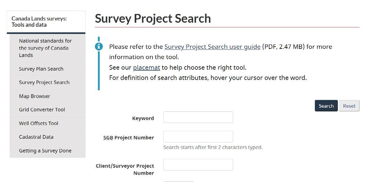
Once the survey project number has been selected from the search results, the Survey Project Details information will appear (refer to page 12 of the Survey Project Search user guide for additional information on the search results).
The Survey Instructions tab will show the dates of:
1 when the CLS requested survey instructions (as discussed on page 27 of this document)
2 when the SGB issued the survey instructions.
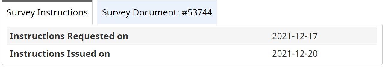
The Survey Document tab will only appear where the CLS has started the on-line submission of the survey plan through MyCLSS.
Within the Survey Document tab, there are several dates that will be filled in according to where the survey plan is in the finalization process.
Survey Instructions Survey Document : #53744
Survey Document Name FINAL PLAN / /
Survey Document Type Plan of Survey of Parcel
Checklist Number 9030
Signed Returns Received 2022-02-24 • by SGB
Outstanding Critical Issue No ••-------
Final Returns Received
Surveyor General
Approved/ Confirmed
CLSR Number
Plan Image Uploaded
Datasets Updated
LTO Number 2022-02-24 ...___ 2022-03-07 1 109 4 9 CLSR BC 2022-03- 10 .____ 2022-03-29 (_____________)
File name assigned by CLS through MyCLSS
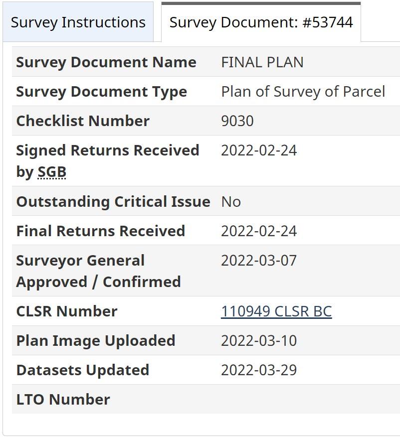
Type of survey plan being prepared
# assigned to online checklist completed by the CLS through MyCLSS. This # will also appear on the survey plan.
Date the CLS submits all required survey project returns to the SGB through MyCLSS
Yes/No box indicates if the survey project returns are acceptable to the SGB or require amendments by the CLS
Date the survey project returns are deemed to be acceptable to the SGB
Date the plan is digitally signed by the SGB representative
CLSR # assigned to the survey plan & also a hyperlink to download the plan
Date the scanned image of the plan was available
Date the SGB’s digital dataset was updated with the applicable survey plan linework and CLSR # Provincial/territorial registry # (applicable only for Official Plans)
A First Nation may find it helpful to refer to this website when trying to determine if survey instructions have been issued, the status of the project once they have approved the plan, the date the surveyor submitted the plan to be reviewed by the SGB, the recording of the plan and the CLSR assigned.
Using the SGB Plan Search website to view and download a copy of the recorded survey plan..
The SGB has created a website that enables the searching and viewing of the scanned Canada Lands Surveys Record(s). The CLSR records include the finalized survey plans, recorded survey reports, field notes, etc. Only those documents that have been recorded in the CLSR are available for viewing through this website. Other documents such as survey instructions, sketches, etc. are not recorded in the CLSR, a First Nation would need to contact the applicable SGB office to inquire about non-recorded survey-related documents.
The Survey Plan Search website is available at: https://clss.nrcan-rncan.gc.ca/clss/plan/search-recherche
Once a survey plan has been assigned a CLSR number (as discussed on page 37 of this document) and the number has been added to the plan, a digital version of the plan is made available for download. If the CLSR number is not known, there are a few other ways to search the website to locate it, such as by the reserve name (Canada Land), name of the CLS (Surveyor), etc. The Survey Plan Search user guide has been prepared to assist in using the website to find the applicable survey project information. The user guide is available by clicking the link on the Survey Plan Search website.
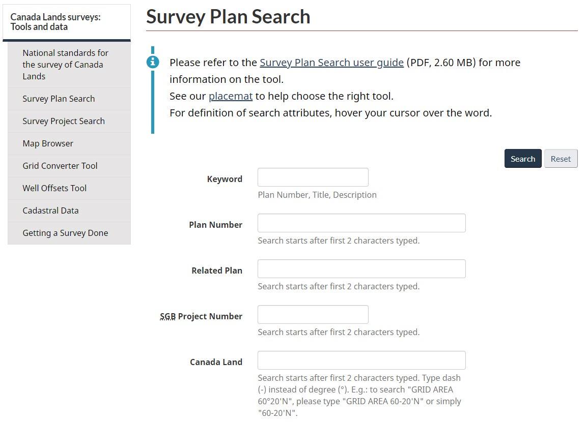
Association of Canada Lands Surveyors (ACLS): https://www.acls-aatc.ca/
• Surveys on Indigenous Lands Tool Kit: https://www.acls-aatc.ca/aboriginal-expertise/surveys-on-indigenous-lands-toolkit/
• Governance and Legislation: https://www.acls-aatc.ca/about-the-association-of-canada-lands-surveyors-acls/governance/
• Find a surveyor tool (locating a CLS in your area): https://www.acls-aatc.ca/find-a-surveyor/
Indian Lands Registry System (ILRS):
• Public Registry (view registry reports): https://services.aadnc-aandc.gc.ca/ilrs_public/Home/Home.aspx?lang=en
• Secured Access (review and retrieve documents and view registry reports): https://pa-ap.sac-isc.gc.ca/logon/LogonPoint/tmindex.html
• Electronic Registry Index Plan (e-RIP): https://geo.aandc-aadnc.gc.ca/erip-prre/splash.html
Indigenous Services Canada (ISC):
• Regional Offices: https://www.sac-isc.gc.ca/eng/1100100016936/1534342668402
• Additional information regarding designation and surrenders: https://www.sac-isc.gc.ca/eng/1385399547742/1613657284614
• Land management programs and information: https://www.sac-isc.gc.ca/eng/1587563382582/1587563402582
Interdepartmental Agreement related to the Cooperation in the Area of Surveys and Specifications for Descriptions of Lands for Transactions on Reserve Lands, 2014 (ILA): https://clss.nrcan-rncan.gc.ca/clss/standards-normes/dl?p=InterdepartmentalAgreement2014_Eng. pdf&type=data
MyCLSS: https://www.myclss.ca/
• ACLS checklist examples (e.g., items that are to be completed by the CLS): https://www.myclss.ca/myclss/index/chcklst-ex/
• Surveyor General Branch review checklist (e.g., items that are reviewed by the SGB upon the plan being submitted by the CLS): https://www.myclss.ca/myclss/index/pc/
• Written permissions/authorizations:
- Prior to the field work (i.e., First Nation written permission): https://www.myclss.ca/myclss/index/pm/
- After the field work (i.e., First Nation approval and re-approval information): https://www.myclss.ca/myclss-monsatc/pdf/BandApprovalForm_e.pdf?version=2.1.2.43
National Aboriginal Land Managers Association (NALMA): https://nalma.ca/
• Staff Contact Information (Head Office): https://nalma.ca/contact
• Regional Lands Associations: https://nalma.ca/associations
• Training Unit Information: https://nalma.ca/units
National Standards for the Survey of Canada Lands (including specific regional chapters): https://clss.nrcan-rncan.gc.ca/clss/surveystandards-normesdarpentage/
Surveyor General Branch datasets/websites:
• Survey Project Search (includes a link to the user guide for this website): https://clss.nrcan-rncan.gc.ca/clss/project-projet/search-recherche
• Survey Plan Search (includes a link to the user guide for this website): https://clss.nrcan-rncan.gc.ca/clss/plan/search-recherche
• CLSS Map Browser (includes a link to the user guide for this website): https://clss.nrcan-rncan.gc.ca/mb-nc/en/index.html
• Canada Lands in Google Earth overlay (includes a link to the user guide for this website): https://www. nrcan.gc.ca/maps-tools-and-publications/maps/canada-lands-surveys/tools-applications-canada-landssurveys/11094#c2
• Canada Lands digital cadastral data: https://clss.nrcan-rncan.gc.ca/data-donnees/sgb_datasets/
• SGB Service Standards (in relation to issuing survey instructions, recording survey documents, and updating the digital cadastral datasets): https://www.nrcan.gc.ca/maps-tools-and-publications/maps/canada-lands-surveys/service-standards-thecanada-lands-survey-system/22954
• Regional offices: https://www.nrcan.gc.ca/maps-tools-and-publications/maps/canada-lands-surveys/aboutcanada-lands/10855