
INTERTIDAL AND SHALLOW SUBLITTORAL FISH AT WALBERSWICK, SUFFOLK J. R. ELLIS
The Suffolk coastline comprises a range of habitats, including large sections of open coast that are generally comprised of pebbles, shingle and sand, and several estuaries (e.g. Rivers Stour, Orwell, Deben, Alde and Ore, and Blyth) with associated mudflats and salt marshes (Hiscock, 1998). Whilst there are a range of trawl surveys in coastal waters (Rogers et al., 1998; Ellis & Rogers, 1999) and some fish sampling from the intake screens at Sizewell (Henderson, 1989), the shallow water marine fauna for most parts of this dynamic coastline has not been subject to meaningful study (Hiscock, 1998). Indeed, the shingle beaches can be quite steeply shelving, which hampers shore-based sampling, and the high turbidity of the southern North Sea, especially in the surf zone, restricts visual surveys.
In addition to the natural sand and gravel habitats along the open coast, there are also a range of artificial habitats, including groynes, piers and harbour walls (Fig. 1). These hard structures provide habitats for a range of marine taxa, including algae, barnacles, hydroids and bryozoans, which provide habitat for associated motile invertebrates, including small crabs, amphipods and shrimps. Such habitats can also support a range of fish species, as they provide shelter and food resources.
The beach at Walberswick, on the south side of the estuary of the River Blyth, comprises a range of sediments, including swathes of sand as well as areas of more


2. Polychaetes and other sessile fauna on the harbour wall at Walberswick (left) and aggregation of sand mason worm Lanice on the sand at Walberswick (right).
mixed sediment, comprising shingle, pebbles and cobbles. It is a dynamic environment and the extent of sandy areas, and how much it may overlay the pebbles and cobbles, varies over time. The harbour wall (and earlier, wooden piling structures immediately to the south) provide hard substrata that may be utilised by those fish that may associate with reefs, as well as providing shelter (and potential feeding grounds) for those fish species occurring on the adjacent sand and sand-pebble habitats. The lower parts of the harbour wall are covered with a complex community of hydroids, bryozoans and polychaetes (Fig. 2), with a few colonies of Sabellaria also present close by. The sediments between the harbour wall and the older piling structures are quite variable with regards the spatial extent of sandy sediments, with aggregations of the polychaete Lanice observed occasionally (Fig. 2).
Preliminary studies on the intertidal and shallow-sublittoral fish occurring at Walberswick, in the vicinity of the harbour wall, were undertaken from June to October in 2022 and 2023. Sampling was generally undertaken at low water, during spring tides, using a small hand net or push net. A small beach seine net was used on one occasion, and a drop net trialled on another occasion, the latter at high water. Fish were kept in seawater after collection, then measured (to the millimetre below) and returned to the sea.
Notes on the various fish taxa recorded are given below, with the taxonomic ordering based on Eschmeyer's Catalog of Fishes (Fricke et al., 2023). All measurements refer to total length, with the sample sizes and length ranges for the observed fish species provided below.
Clupea harengus Linnaeus, 1758
FAMILY CLUPEIDAE
Atlantic herring
This small pelagic fish was only caught when using a beach seine, with 19 specimens recorded on 5 July 2023. The mean length of these specimens was 53.7 mm, and the observed length range was 49–59 mm.
Sprattus sprattus (Linnaeus, 1758) Sprat Two small specimens (length range: 41–52 mm) caught by drop net (11 August 2023).
FAMILY GAIDROPSARIDAE
Ciliata mustela (Linnaeus, 1758)
Five-bearded rockling
Two specimens (42 and 50 mm) caught by hand net on 15 July 2022, and two larger specimens (101 and 103 mm) caught by hand net on 16 August 2023. This species is known to be relatively abundant along parts of the Suffolk coast (Rogers et al., 1998).
FAMILY CALLIONYMIDAE
Callionymus lyra Linnaeus, 1758
Common dragonet
One specimen (61 mm, Fig. 3) caught by hand net on 1 September 2023. This individual was in one of the scoured pits that surround some of the concrete pilings and are exposed at low water, forming an intertidal pool.

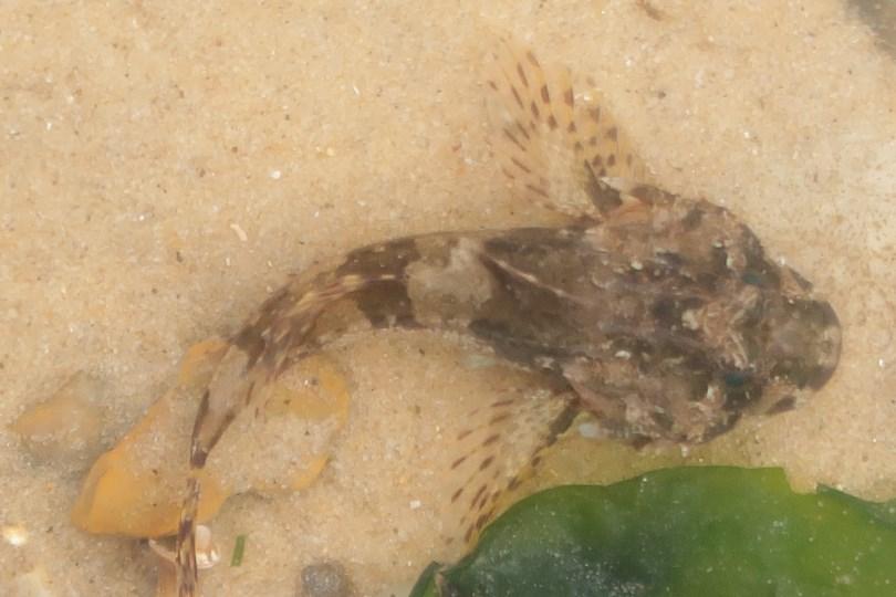
Figure 3. Common dragonet Callionymus lyra (left) and sea scorpion Taurulus bubalis (right) caught at Walberswick (1 September 2023).
FAMILY SYNGNATHIDAE
Entelurus aequoreus (Linnaeus 1758)
Snake pipefish
Two specimens (49 and 302 mm) caught by hand net on 13 September 2023. Whilst other species of pipefish that are more typical of inshore waters would also be expected to occur (Collings, 1933), the snake pipefish reported here were found after some poor weather and so may have been brought inshore by water movements.
FAMILY GOBIIDAE
Pomatoschistus minutus (Pallas, 1770)
Sand goby
A single specimen (67 mm) caught by hand net on 13 October 2023 on the sand between the harbour wall and wooden pilings.
Pomatoschistus spp.
Three other species of the genus Pomatoschistus are known to occur in the shallow waters of the southern North Sea, namely common goby Pomatoschistus microps (Krøyer, 1838), which typically occurs in more estuarine waters, painted goby Pomatoschistus pictus (Malm, 1865) in inshore waters, and Lozano’s goby Pomatoschistus lozanoi (de Buen, 1923) in inshore waters and outside estuaries (Fonds, 1973; Miller, 1986; Kirby et al., 2003). Species-specific data were not always collected for gobies in the genus Pomatoschistus. The correct identification of some members of this genus, including P. minutus and P. lozanoi, can be problematic
(Webb, 1980), as some distinguishing features (such as markings and coloration) vary between sexes and maturity stage. The more robust identification features, such as the arrangement of the suborbital papillae, requires microscopic identification (Miller, 1986; Hamerlynck, 1990), and so cannot be done reliably in the field. Furthermore, there is also evidence that some members of this genus can hybridize, including P. minutus and P. lozanoi (Wallis & Beardmore, 1980).
During 2022, members of this genus were observed on 15 July (n = 2; 23–24 mm), 14 August (n = 3; 23–36 mm), 10 September (n = 2; 28–32 mm), 11 September (n = 4; 31–52 mm) and 8 October (n = 3; 24–46 mm). During 2023, they were observed on 5 July (n = 8; 36–49 mm), 4 August (n = 2; 22–46 mm), 11 August (n = 1; 58 mm), 17 August (n = 2; 14–17 mm), 13 September (n = 5; 14–37 mm), 28 September (n = 1; 26 mm) and 29 September (n = 8; 25–43 mm).
FAMILY SCOPHTHALMIDAE
Scophthalmus rhombus (Linnaeus, 1758)
Brill
One specimen (106 mm; Fig. 4) caught by push net on 11 September 2022. The early stages of this flatfish are often found on exposed sandy beaches.
FAMILY PLEURONECTIDAE
Platichthys flesus (Linnaeus, 1758) Flounder
One specimen (39 mm) caught by push net on 22 June 2023. This is a relatively common flatfish along the Suffolk coast (Rogers et al., 1998), and the young are usually associated with estuarine waters.
Pleuronectes platessa Linnaeus, 1758 European plaice
One specimen (51 mm) caught by push net on 22 June 2023. This is a relatively common and widespread flatfish along the Suffolk coast (Rogers et al., 1998) occurring in more saline waters than flounder.
FAMILY SOLEIDAE
Solea solea (Linnaeus, 1758)
Common sole
Single specimens caught by push net on 11 September 2022 (108 mm) and 17 August 2023 (82 mm; Fig. 4). This is a relatively common and widespread flatfish along the Suffolk coast (Rogers et al., 1998).


FAMILY MUGILIDAE
Mugilidae (indet.) Grey mullets
Large numbers of grey mullet fry (15–26 mm) were observed on 10 and 11 September 2022, with further specimens (11–26 mm) observed on 8 October 2022. These specimens were mostly sampled from small pools of water that had been cut off by the falling tide. Three species of grey mullet reproduce in UK waters, and correct species identification of the early stages requires close examination of the chromatophores on the ventral surface of the head (Reay & Cornell, 1988).
FAMILY BLENNIIDAE
Lipophrys pholis (Linnaeus, 1758) Shanny Shanny (or blenny; Fig. 5) was encountered frequently, being the main species caught by hand net at the base of the harbour wall. During 2022, specimens were recorded on 14 August (n = 11; mean length = 36.9 mm; length range = 30–46 mm), 10 September (n = 14; mean length = 44.9 mm; length range = 37–54 mm), 11 September (n = 4; 38–53 mm) and 8 October (n = 1; 45 mm).
During 2023, specimens were recorded on 6 June (n = 1; 65 mm), 22 June (n = 5; mean length = 62.2 mm; length range = 58–69 mm), 2 August (n = 19; mean length = 22.8 mm; length range = 14–36 mm), 4 August (n = 35; mean length = 20.9 mm; length range = 16–33 mm), 16 August (n = 22; mean length = 27.7 mm; length range = 18–40 mm), 31 August (n = 10; mean length = 39.7 mm; length range = 26–67 mm), 1 September (n = 4; length range = 27–40 mm), 13 September (n = 6; length range = 31–51 mm), 15 September (n = 6; length range = 23–49 mm) and 28–29 September (n = 2; 51–59 mm).
Specimens recorded in early August 2023 included several early stages, with those in the 14–17 mm length range included post-larval forms with a translucent body and

FAMILY TRACHINIDAE
Echiichthys vipera (Cuvier, 1829) Lesser weever
A frequent species at Walberswick, being collected by push net, beach seine and even hand net. Specimens were recorded on 19 June 2022 (129 mm), 10 September 2022 (64 mm), 5 July 2023 (n = 4; 68–105 mm), 2 August 2023 (72 mm) and 4 August 2023 (64 mm). Lesser weever (Fig. 6) was observed on the sandy sediments south of the pilings, and also on the sandy sediments close to the harbour wall. Lesser weever is relatively abundant along parts of the Suffolk coast (Rogers et al., 1998). It is an ambush predator that feeds on small crustaceans and small fish (Creutzberg & Witte, 1989; Vasconcelos et al., 2004) and so would likely benefit from the abundant small

FAMILY COTTIDAE
Taurulus bubalis (Euphrasen, 1786) Sea scorpion
Single specimens caught by hand net on 1 September 2023 (62 mm; Fig. 3) and 13 September 2023 (65 mm).
FAMILY MORONIDAE
Dicentrarchus labrax (Linnaeus, 1758) European sea bass
One specimen (96 mm) caught by beach seine on 5 July 2023. This is a fast-moving fish and further beach seine sampling would be required to sample this species more effectively.
The above list, comprising 16 taxa, should be recognised as being from preliminary observations, and further sampling and/or the use of different gears would be expected to yield further fish species. Nevertheless, the current observations provide initial data for the inshore marine fish of this location, noting that there are limited, site-specific data for the shallow, sublittoral fish occurring along the Suffolk coast.
Whilst there are seemingly no earlier data relating specifically to the harbour wall and adjacent beach at Walberswick, Wake (1842) provided an early list of the fishes occurring in Southwold Bay, though these were likely based largely on those fish landed by commercial fishers. Wake’s (1842) list of fishes is shown overleaf in Appendix 1, with an updated scientific nomenclature. Collings (1933), in his account of the fishes of Suffolk, gave detailed notes on the fish species that had been observed at Southwold, Walberswick and from the River Blyth, and more than thirty of these species had not been noted by Wake (1842). In terms of the more inshore and coastal fish species reported by Collings (1933) from the study area, these included common stingray Dasyatis pastinaca, allis shad Alosa alosa, twaite shad Alosa fallax, sand smelt Atherina presbyter, bib Trisopterus luscus, garfish Belone belone, three-spined stickleback Gasterosteus aculeatus, greater pipefish Syngnathus acus, broad-nosed pipefish Syngnathus typhle, bullrout Myoxocephalus scorpius, sea scorpion Taurulus bubalis, sea-snail Liparis liparis, Montagu's sea-snail Liparis montagui, pogge Agonus cataphractus, European sea bass Dicentrarchus labrax, ballan wrasse Labrus bergylta, shanny Lipophrys pholis, eelpout (or viviparous blenny) Zoarces viviparus, greater weever Trachinus draco, transparent goby Aphia minuta, sand goby Pomatoschistus minutus and common dragonet Callionymus lyra. Interestingly, eelpout was considered to be common in the estuarine parts of the River Blyth at this time (Collings, 1933), although none were observed during the present study.
Despite the extensive data relating to the marine fish of the southern North Sea, as derived from trawl surveys (Heessen et al., 2015; Broad & Ellis, 2020), there are more limited data on the coastal and estuarine fish of the county and more detailed studies of this fish assemblage are required in order to provide a more robust, contemporary account of the ichthyofauna of Suffolk.
Acknowledgements
Many thanks to Gen Broad for providing comments on the paper.
References
Broad, G. & Ellis, J. R. (2020). Marine fishes of the south-western North Sea. Trans. Suffolk Nat. Soc., 56: 37–50. Collings, D. W. (1933). The fishes of Suffolk. Trans. Suffolk Nat. Soc., 2: 104–133. Creutzberg, F. & Witte, J. I. (1989). An attempt to estimate the predatory pressure exerted by the lesser weever, Trachinus vipera Cuvier, in the southern North Sea. Journal of Fish Biology, 34: 429–449.
Ellis, J. R. & Rogers, S. I. (1999). The marine fauna off the coast of East Anglia. Trans. Suffolk Nat. Soc., 35: 45–56. Fonds, M. (1973). Sand gobies in the Dutch Wadden Sea (Pomatoschistus, Gobiidae, Pisces). Netherlands Journal of Sea Research, 6: 417–478.
Ford, E. (1922). On the young stages of Blennius ocellaris L., Blennius pholis L., and Blennius gattorugine L. Journal of the Marine Biological Association of the United Kingdom, 12: 688–692.
Fricke, R., Eschmeyer, W. N. & Van der Laan, R. (Eds) (2023). Eschmeyer's Catalog of Fishes. Available at http://researcharchive.calacademy.org/research/ichthyology/ catalog/fishcatmain.asp). Electronic version accessed 08 08 2023.
Hamerlynck, O. (1990). The identification of Pomatoschistus minutus (Pallas) and Pomatoschistus lozanoi (de Buen)(Pisces, Gobiidae). Journal of Fish Biology, 37: 723–728.
Heessen, H. J. L., Daan, N. & Ellis, J. R. (Eds.) (2015). Fish atlas of the Celtic Sea, North Sea, and Baltic Sea. Wageningen Academic Publishers / KNNV Publishing, 572 pp. Henderson, P. A. (1989). On the structure of the inshore fish community of England and Wales. Journal of the Marine Biological Association of the United Kingdom, 69: 145–163.
Hiscock, K. (1998). Marine Nature Conservation Review. Benthic marine ecosystems of Great Britain and the north-east Atlantic. Joint Nature Conservation Committee (Peterborough).
Kirby, M. F., Bignell, J., Brown, E., Craft, J. A., Davies, I., Dyer, R. A., Feist, S. W., Jones, G., Matthiessen, P., Megginson, C. & Robertson, F. E. (2003). The presence of morphologically intermediate papilla syndrome in United Kingdom populations of sand goby (Pomatoschistus spp.): endocrine disruption? Environmental Toxicology and Chemistry: An International Journal, 22: 239–251.
Miller, P. J. (1986). Gobiidae. In: Fishes of the North·eastem Atlantic and the Mediterranean. Volume 3 (P.J.P. Whitehead, M.-L. Bauchot, J.-C. Hureau, J. Nielsen and E. Tortonese, Eds.). Paris: UNESCO, pp. 1019–1085.
Reay P. J. & Cornell, V. (1988). Identification of grey mullet (Teleostei: Mugilidae) juveniles from British waters. Journal of Fish Biology, 32: 95–99.
Rogers, S. I., Millner, R. S. & Mead, T. A. (1998). The distribution and abundance of young fish on the east and south coast of England (1981 to 1997). Science Series Technical Report (CEFAS, Lowestoft), 108: 130 pp.
Vasconcelos, R., Prista, N., Cabral, H. & Costa, M. J. (2004). Feeding ecology of the lesser weever, Echiichthys vipera (Cuvier, 1829), on the western coast of Portugal. Journal of Applied Ichthyology, 20: 211–216.
Wake, R. (1842). Southwold, and its vicinity, ancient and modern. Second Edition. London: W. H. Dalton, xviii + 420 pp.
Wallis, G. P. & Beardmore, J. A. (1980). Genetic evidence for naturally occurring fertile hybrids between two goby species, Pomatoschistus minutus and P. lozanoi (Pisces, Gobiidae). Marine Ecology Progress Series, 3: 309–315.
Webb, C. J. (1980). Systematics of the Pomatoschistus minutus complex (Teleostei: Gobioidei). Philosophical Transactions of the Royal Society of London B, Biological Sciences, 291(1049): 201–241.
J.R. Ellis, CEFAS, Pakefield Road, Lowestoft, Suffolk, NR33 0HT
Appendix I Updated nomenclature for Wake’s (1842) list of fishes of Southwold Bay
20 Lotidae
19
Lota vulgaris
Molva molva (L., 1758)
Burbot
Ling
[8] See p.
Lota molva
Ling-
Gaidropsaridae Ciliata mustela (L., 1758) Fivebearded rockling Motella glauca Mackarel midge [7]
18 Zeidae
Zeus faber L., 1758 John dory
Zeus faber Dory
17 Osmeridae Osmerus eperlanus (L., 1758) Smelt Osmerus eperlanus
Smelt
16 Salmo trutta L., 1758 Sea trout Salmo trutta Salmon trout
15 Salmonidae
Salmo salar L., 1758
Atlantic salmon
Salmo salar
Salmon
14 Alosa sp. ( Alosa alosa ( L., 1758)) Shad Alosa communis Shad [6]
13 Sprattus sprattus (L., 1758) Sprat
Clupea sprattus Sprat-Clupea alba White bait [5]
12 Clupea harengus L., 1758
Atlantic herring Clupea harengus Herring
11 Clupeidae Sardina pilchardus (Walbaum, 1792) Pilchard Clupea pilchardus
10 Anguillidae
Pilchard
Anguilla anguilla (L., 1758) European eel Anguilla acutirostris
Sharpnosed eel
9 Congridae Conger conger (L., 1758) European conger eel Conger vulgaris Conger eel
8 Acipenseridae Acipenser sturio L., 1758
Atlantic sturgeon Acipenser sturio
Common sturgeon
7 Raja montagui Fowler, 1910 Spotted ray Raia maculata Homelyn ray, homer
6 Raja clavata L., 1758 Thornback ray Raia clavate Thornback
5 Rajidae
4 Squatinidae
3
2
1
-
Scyliorhinidae
Dipturus batis (L., 1758)
Common blue skate
Raia batis
Skate-Raia chagrinea Longnosed skate [4]
Squatina squatina (L., 1758) Angel shark
Scyliorhinus stellaris (L., 1758)
Greaterspotted dogfish
Scyliorhinus canicula (L., 1758) Lesserspotted dogfish
Squatina angelus
Scyllium catulus
Angel fish
Scyllium canicula
LamnidaeCarcharias vulgaris
Largespotted dog fish [3]
Alopiidae
Alopias vulpinus (Bonnaterre, 1788)
Common thresher
Carcharias vulpes
Smallspotted dog fish
White shark [2]
Branchiostomatidae
Family
Fox shark
lanceolatum (Pallas, 1774)
Lancelet
Branchiostoma
Scientific name (current)
Common name (current)
Amphioxus lanceolatus
Lancelet [1]
Scientific name (Wake, 1842)
Common name (Wake, 1842)
Notes
See p. 79
44 Molidae Mola mola (L., 1758)
43 Lophiidae
42 Cyclopteridae
41 Triglidae
Sunfish
Lophius piscatorius L., 1758
Cyclopterus lumpus L., 1758
Orthagoriscus mola
Anglerfish Lophius piscatorius
Lumpsucker Cyclopterus lumpus
Chelidonichthys cuculus (L., 1758) Red gurnard Trigla cuculus
40 Trachinidae Echiichthys vipera (Cuvier, 1829)
Lesser weever Trachinus vipera
Sun fish
Fishing frog
Lump sucker
Red gurnard
Lesser weever
39 Hyperoplus lanceolatus (Le Sauvage, 1824) Greater sandeel Ammodytes lancea Sand launce [13]
38 Ammodytidae Ammodytes tobianus L., 1758
Common sandeel Ammodytes tobianus Sand eel
37 Mugilidae Chelon sp. Grey mullet Mugil capito Gray mullet [12]
36 Soleidae Solea solea (L., 1758)
SoleExocoetidaeExocetus volitans
Flying fish [11]
35 Hippoglossus hippoglossus (L., 1758)
34 Limanda limanda (L., 1758)
33 Platichthys flesus (L., 1758)
32 Pleuronectidae
Pleuronectes platessa L., 1758
31 Bothidae Arnoglossus laterna (Walbaum, 1792)
30 Scophthalmus rhombus (L., 1758)
29 Scophthalmidae
Scophthalmus maximus (L., 1758)
28 Syngnathidae Nerophis lumbriciformis (Jenyns, 1835)
27 Scombridae Scomber scombrus L., 1758
26 Merlucciidae Merluccius merluccius (L., 1758)
25
24
23
22
Common sole Solea vulgaris
Atlantic halibut Hippoglossus vulgaris
Dab Platessa limanda
Flounder Platessa flesus
European plaice Platessa vulgaris
Scaldfish Rhombus arnoglossus
Brill Rhombus vulgaris
Turbot
Pollachius pollachius (L., 1758)
Pollachius virens (L., 1758)
Merlangius merlangus (L., 1758)
21 Gadidae
Rhombus marinus
Worm pipefish Syngnathus lumbriciformis
Atlantic mackerel Scomber scomber
European Hake Merluccius vulgaris
Pollack
Merlangius pollachius
Saithe Merlangus carbonarius
Whiting
Holibut
Common dab
Flounder
Plaice
Scald fish
Brill
Turbot
Worm pipe fish
Mackarel
Hake
Pollack
Coal fish [10]
Merlangus vulgaris
Melanogrammus aeglefinus (L., 1758) Haddock Morrhua aeglefinus
Whiting
Haddock [10]
No.
Gadus morhua L., 1758
Family Scientific name (current)
Appendix I continued
Atlantic cod
Common name (current)
Morrhua vulgaris
Common cod-Morrhua callarias
Dorse [9]
Scientific name (Wake, 1842)
Common name (Wake, 1842)
Notes
Notes:
[1] Whilst Branchiostoma lanceolatum is a chordate, it is not a ‘fish’ and not within the taxa Agnatha, Chondrichthyes or Osteichthyes.
[2] Wake (1842) listed white shark Carcharias vulgaris, which would be questionable. It may possibly refer to a misidentified porbeagle Lamna nasus or blue shark Prionace glauca.
[3] Wake (1842) listed large-spotted dog fish Scyllium catulus. This binomen is generally considered a junior synonym of Scyliorhinus canicula, although the common name used would indicate the record referred to Scyliorhinus stellaris.
[4] Wake (1842) listed long-nosed skate Raia chagrinea, which is unclear. Raia chagrinea is a junior synonym of shagreen ray Leucoraja fullonica, whilst long-nosed skate is generally used for Dipturus oxyrinchus. Both these species occur much further offshore and would be unlikely to occur in Southwold Bay, and so this record is not accepted here.
[5] Wake (1842) listed ‘white bait’ Clupea alba which presumably relates to juvenile herring Clupea harengus.
[6] Wake (1842) listed shad as Alosa communis. Whilst A. communis is a junior synonym of Alosa alosa (L., 1758), it is accepted here at the genus level only (Alosa sp.), as both Alosa alosa and Alosa fallax were reported from the area by Collings (1933).
[7] Wake (1842) listed mackarel midge Motella glauca. This is presumed to be the early stage of a rockling, the most likely to occur being five-bearded rockling Ciliata mustela.
[8] Wake (1982) listed burbot Lota vulgaris (now valid as Lota lota), which is a freshwater species and so would not be expected to occur in Southwold Bay. The record may possibly have related to another species of rockling.
[9] Atlantic cod was recorded under two scientific names, with Morrhua callarias a junior synonym.
[10] Both haddock Melanogrammus aeglefinus and saithe Pollachius virens are more northerly fish species, and now infrequent in the southern North Sea.
[11] Wake (1982) listed flying fish Exocetus volitans (=Exocoetus volitans), although this is a tropical species and not reported from the waters around the British Isles. Other species, such as Mediterranean flying fish Cheilopogon heterurus and blackwing flying fish Hirundichthys rondeletii may occur to the southwest of the British Isles, and so this record requires further investigation before it can be validated.
[12] Wake (1842) listed ‘gray mullet’ Mugil capito. Whilst M. capito is regarded as a junior synonym of Chelon ramada (Risso, 1827), it is accepted here at the genus level only (Chelon sp.), as three species of grey mullet are known to reproduce in UK waters.
[13] Wake (1842) listed sand eel Ammodytes tobianus and sand launce Ammodytes lancea. Whilst the latter is considered to be a synonym of Ammodytes tobianus (see Fricke et al., 2023), the listing of two sandeel species indicates that the latter name may have been used for greater sandeel Hyperoplus lanceolatus, given that this species also occurs in the area.