
A LOOK BACK AT THE HOLTON GRAVEL PIT IN N.E. SUFFOLK HOWARD MOTTRAM & BOB MARKHAM
This defunct gravel pit is located to the south-east of the village of Holton, at around OS National Grid Reference TM 404 773. The Holton Pit is not shown on the OS maps that were published up to and including 1946 but it is shown, following resurveying up to 1947, on the OS map at the 1:10,560 scale that was published in 1951. However, the pit shows on an RAF aerial photo dated 1945. It is therefore likely that the pit opened up in the 1940s for the post-World War II construction boom that gained momentum in the early 1950s.
A written account of how these workings had stood in 1953 confirmed that they lay to the north of the B1123, Southwold Road, and the account added that the workings progressed approximately eastwards (Spencer, 1972 p.342-345). The pit faces at that time were described as exhibiting the Westleton Beds as dipping beds of flint gravel without thick intervening beds of sand. Cutting down into the top of the Westleton Beds were channels infilled with glacial till (Lowestoft Till).
NB Spencer’s account also refers to Gipping Till and Norwich Brickearth. Today we understand that these are weathered forms of Lowestoft Till.
The pit appears little changed by the time of the release of the OS 1:10,560 map published in 1958 and which incorporated resurvey updates to 1957, see Fig. 1.

In 1958, the site was visited by the Geologists’ Association. It is most likely that the observations made during this field trip concurred with the previous descriptions as the only new insight into the geology was that Harold Spencer had found the dog whelk (Nucella lapillus) at the site (Baden-Powell & West, 1960).
There is a more detailed account of the stratigraphy that was visible in the early to mid-1960s (Hey, 1967). The exposure by then was described as about 320m long x 12m high. The western end of the workings mainly displayed beds of flint gravel, as noted earlier, with the beds of gravel dipping down south-eastwards at 10°. At the eastern end of the workings, the dip of the beds of gravel had flattened off to 3° and beds of sand became more common, particularly at the higher levels where they overlay the beds of gravel “unconformably” (cut and fill). The beds of sand dipped east-south-eastwards at 10° and passed upwards into more flint gravel (only 2% of the pebbles in the 32-16mm dia. size range were composed of anything other than flint). Occasionally, the tops of the beds of flint gravels were cut into by shallow channels of “quartzose gravels”. The orientation of the channels was not stated but it is unlikely that they would have been readily recognised as channels unless they ran through the face somewhat obliquely. These so called “quartzose gravels”, initially referred to as White Ballast (Hey, archived working papers) and then Upper Gravels (Hey, 1967), were still largely composed of flint pebbles. In the 32-16mm dia. size range, Hey’s sample was composed of 81% flints, 16% vein quartz and quartzite rock and 3% chert (mainly Carboniferous but a little from the Lower Greensand). Heavy mineral analysis of the 120-85 µm fraction revealed 40% zircon, 28% tourmaline, 11% rutile, 8.5% garnet, 6.5% stauralite and 6.5% kyanite.

It was mentioned that as the pit was worked northwards, towards Blyford Lane, the ground level became higher and commensurately the till became thicker (Spencer, 1972). As this observation was qualified as only having been recorded a few years before being published, it presumably indicated how the site had progressed by the late 1960s to early 1970s. See also Fig. 2.
There are some 50 specimens of fossils and rocks, collected from various levels of the site, which are lodged at the Ipswich Museum. Specimens collected from below the water table included large erratics, shale with traces of coal, antler fragments, teeth and material that has often been partly pyritsised, namely; - bones, shells and wood (including pine and oak). The bones were stated to include comb-antlered deer (Euctenoceras sedgwicki, E. falconeri, E. cf. tetraceros), moose (Cervalces gallicus), horse (Equus) and the southern mammoth (Mammuthus meridionalis) (Spencer, 1972). Ferruginious bones, mainly of mammoth, were also noted from above the water table but at the higher levels the bones became less ferruginous so that they were more friable and difficult to preserve.

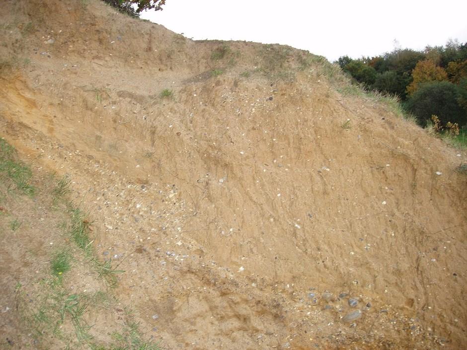
By the 1980s the exposures in the main area of the pit had become degraded and only glimmers of what had been here were visible, see Fig. 3.
There was also some shallower working north of Blyford Lane at around TM 4061 7745 that was only poorly visible in 1985. However, by 1988 exposures had improved and had extended westwards. Natural England, then known as English Nature, designated the new workings as an SSSI. The BGS referred to these exposures as “rear face” and in 1992 described them as exposing the uppermost 6m or so of the strata at
Holton (Moorlock et al., 2000, p.41). The BGS stated that the exposures mainly revealed sand and that there was no perceptible change upwards from the Westleton Beds into a 0.3m thick bed of gravel with a sand matrix where 10% of the pebbles were quartzose. Shortly afterwards, in 1994, Natural England visited the site and its SSSI citation states that there was around 5m of the Westleton Beds. Natural England attributed the overlying “quartzose gravels” to the Kesgrave Sands & Gravels which were overlain by Lowestoft Till.
By 2004, when geological sites in Suffolk were being surveyed by GeoSuffolk, the exposures in the “rear face” were rapidly degenerating. Fortunately, Lowestoft Till that had slumped or flowed into a channel in the underlying beds was identifiable, see Fig. 4.
NB As ideas developed in the 1970s and early 1980s, widely spread “quartzose gravels” in Suffolk were often attributed to the Kesgrave Sands & Gravels that had been deposited by a pre-glacial forerunner of the River Thames during the Lower to Middle Pleistocene. By the mid to late 1980s, it was considered that in northern Suffolk, that the “quartzose gravels” were deposited by a contemporaneous river, the Ingham/Bytham River. During its remapping of north-eastern Suffolk between 1990 and 1993, the BGS reported that it had only found Ingham/Bytham deposits in this
area in boreholes. “Quartzose gravels” that the BGS found near the surface or beneath the Lowestoft Till in the vicinity of Holton were shown as glacial outwash on the revised geological map of the area (BGS, 1996).
By the late 1990s, the Wroxham Crag, which is also quartzose, was newly inserted into the stratigraphic column and the current BGS Lexicon of Named Rock Units states that the Wroxham Crag extends at least as far south as Halesworth. It appears that the BGS has therefore informally reassigned, to the Wroxham Crag, some of the deposits that it had previously designated as Ingham/Bytham Sands & Gravels or Glacial Sands & Gravels.
However, we have previously noted that quartzose pebbles can occur within the Westleton Beds. At Covehithe (Mottram, 1989) these pebbles seem to be due to fluctuations of the sediment supply but when quartzose pebbles occur within the top of the Westleton Beds, particularly directly beneath till, we have to be wary that these “quartzose gravels” could be glacial outwash deposits. Therefore, the attribution of the “quartzose gravels” at Holton would benefit from further work as a glacial origin is very creditable, with outwash streams possibly having reworked the underlying crags and river deposits such that the resulting glacial outwash deposits would be difficult to distinguish from the underlying crag and river sediments from which they may have been largely derived.

References
Baden-Powell, D. F. W & West, R. G. (1960). Summer Field Meeting in East Anglia. 1424 August 1958. Proc. Geol. Assoc., 71: 61-80.
BGS, (1996). 1:50,000 geological map series, New Series Sheet 176 (Lowestoft), solid and drift geology. British Geological Survey, Keyworth.
Hey, R. W. (1967). The Westleton Beds reconsidered. Proc. Geol. Assoc. 78: 427-445.
Moorlock, B. S. P., Hamblin, R. J. O., Booth, S. J. & Morigi, A. N. (2000). Geology of the country around Lowestoft and Saxmundham. Memoir of the British Geological Survey, Sheets 176 and 191 (England and Wales). British Geological Survey, Keyworth.
Mottram, H. B. (1989). The Upper Caenozoic sequences around The Long Row, Covehithe. Trans. Suff. Nat. Soc. 25: 86-91.
https://issuu.com/suffolknaturalistssociety/docs/tsns25t.
Sedgwick Museum Archives - OE368 (Hey). Sedgwick Museum of Earth Sciences, University of Cambridge.
Spencer, H. E. P. (1972). A contribution to the geology of Suffolk – Part 5. Trans. Suffolk Nat. Soc. 15: 279-356.
https://issuu.com/suffolknaturalistssociety/docs/tsns15_4_d
Suffolk Geosite Records - Holton. GeoSuffolk.
Corresponding author
H. B. Mottram salhow@talktalk.net