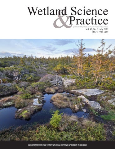
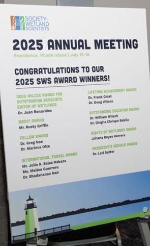
Proceedings from the 2025 Annual Meeting of the Society of Wetland Scientists
July 2025 • Providence, Rhode Island
This year’s annual meeting was held in Providence, Rhode Island from July 15-18. The general theme for the meeting was “Navigating the Waters: Wetland Science, Evolving Policy, and the Future of Our Landscape.”
Many symposia were organized to address a variety of topics:
1. Wetland restoration planning considering marsh migration
2. Wetland carbon policy and science
3. Functions of wetland ecosystems in coastal watersheds
4. Adaptation of wildlife conservation to changing wetland dynamics and policies
5. Updates on the effects of US Supreme Court decision on Sackett vs EPA
6. Rights of wetlands policy
7. Lessons learned from adding sediment to coastal marshes
8. Remote sensing approaches to quantifying wetland functions
9. Microbial activity in wetlands
10. Wetland conservation in Peru
11. Science-based wetland management for climate benefits
12. Evolving wetland policy at federal, state, and local levels
13. Water quality monitoring for wetland restoration
14. Wetland biogeochemistry and global change
The conference also included presentations on a range of topics under six general headings:
1. Biology and ecology
2. Global climate change and policy
3. Education and communication
4. Management and applied science
5. Physical sciences
6. Policy
The following are the abstracts from the oral and poster sessions, listed by the date of the presentations. The proceedings include the presentations and posters where an abstract was provided. Thanks to Peter Backhaus for assembling these abstracts. Minor editing was done mainly for formatting.
Symposia:
Navigating Upstream:
Planning and Implementing Restoration with Consideration for Marsh Migration (July 16)
The focus of this symposium is to present a variety of wetland restoration projects as case studies, at different phases (early development, feasibility, engineering, permitting, design, and construction / implementation) which all share a common thread, enabling marsh migration. Additional talks may include detailed discussions of tools available to estimate, model, and predict sea level rise relevant to the restoration planning phase. The goal of this symposium is to share examples of both intentional planning and results that address consideration of sea level rise, and migration, as well as examples where marsh migration may have happened organically as a consequence of restoration methodology to share, discuss and generally improve best practices and knowledge for restoration practitioners.
Planning for Marsh Migration and Sea Level Rise: Massachusetts Salt Marsh Restoration Case Studies
Cristina Kennedy, MA Division of Ecological Restoration, cristina.g.kennedy@mass.gov
Sea level rise (SLR) must be considered in salt marsh restoration projects. Hydrodynamic modeling that includes SLR projections is commonly used in project planning, however the choice of SLR scenario and future time horizon have major implications in terms of projected flood impacts and salt marsh migration potential. This talk will review SLR modeling results and mapping outputs from recently completed and active restoration projects in coastal Massachusetts. For example, modeling using a more conservative estimate of SLR (using down-scaled data for Massachusetts based on the 2017 National Climate Assessment) may predict that upstream freshwater wetlands have no marsh migration potential because the area will be permanently inundated by 2070, whereas using more recent climate change data indicates that tidal conditions may be appropriate to allow for salt marsh establishment. As SLR data becomes more commonly used in salt marsh restoration projects practitioners need
to think carefully about what data to use and how to interpret the data.
Paddling through Planning: The Early Stages of the Pamet River
Restoration
Project
Elizabeth Gorrill, MA Division of Ecological Restoration, elizabeth.gorrill@mass.gov
The Pamet River located in Truro, Massachusetts flows west from the back side of barrier beach dunes on the Atlantic to Cape Cod Bay. In 1869, the river was diked forming the first of two major restrictions that exist around the mid-point of the 4.2 mile river. The restrictions block salt water and tidal flow from the former salt marsh in the upper portion of the system and cause slow drainage of the upper system during overwash events from the Atlantic. The Pamet River Restoration Project aims to restore tidal flow to the upper portion of the river system to restore the salt marsh ecology and increase resiliency for the properties along the river. The paddle through planning will discuss the measures being taken in the planning process to address sea-level rise and marsh migration, as well as the rough waters we’ve faced in planning due to the intricacies of the project.
Runnel Restoration and Marsh Migration in Cape Cod Salt Marshes
Hillary Sullivan, Woodwell Climate Research Center, hillary.marchwinski@gmail.com
Microtidal marshes on the south side of Cape Cod have high vulnerabilities to sea level rise and other anthropogenic stressors and are increasingly experiencing an emergence of pannes with shallow standing water. In December 2023, we installed runnels, shallow channels designed to promote drainage and revegetation, in five salt marsh pools in the most degraded marsh in Waquoit Bay’s Sage Lot Pond complex. Runnels reduced standing water and increased sediment redox potential thus leading to conditions suitable for vegetation recolonization. Based on the success of hydrological manipulations in Sage Lot and in nearby Buzzards Bay, MA, we undertook restoration planning for two additional marsh complexes in Waquoit Bay, MA. However, the marsh elevation capital is very low in Sage Lot Pond and small-scale hydrological manipulations will not ensure persistence of vegetated marsh with accelerating
climate change impacts coupled with the transition to an upward phase of the metonic cycle. We will describe our successful hydrological restoration, and introduce additional restoration plans in the current tidal frame using landscape scale tools and elevation models to identify areas suitable for marsh migration. A variety of approaches are envisioned for marsh migration facilitation including removing barriers to natural halophyte colonization, sediment augmentation, and propagating early successional halophytes into bare areas of the marsh.
Coastal Cranberry Bogs as Future Salt Marsh Migration Corridors
Evelyn Mortimer, Buzzards Bay Coalition, mortimer@savebuzzardsbay.org
Former coastal cranberry bogs in Southeastern Massachusetts restrict natural tidal flow due to undersized culverts and remnants of agricultural infrastructure. This disruption inhibits marsh hydrology, chemistry, and vegetation, therefore increasing vulnerability to climate threats such as sea level rise and storm surge. The Buzzards Bay Coalition, in collaboration with several project partners, is working to restore coastal wetland habitat by integrating cranberry bog restoration and salt marsh migration to inform future restoration efforts throughout the region. A technical memorandum and hydrodynamic modeling—incorporating hydrologic and hydraulic analyses, sea level rise projections, salinity, and tidal data—have guided the initial engineering designs. Conceptual designs consider future sea level rise and storm surge scenarios, with the goal of restoring tidal marsh to the greatest extent under these conditions. Key discussion essential for the next phase of the project will focus on strategies to eliminate barriers to tidal inundation and facilitate marsh migration without increasing flood risk to surrounding infrastructure.
Salty Cranberries: Planning for the Future of the Cold Brook Preserve
Eric Ford, MA Division of Ecological Restoration, eric.ford@mass.gov
The Robert F. Smith Cold Brook Preserve is a 66+/acre tract of conservation land located in Harwich Port, Massachusetts. Cold Brook (which runs through the property), along with its associated riparian
wetlands and supporting upland areas were altered and subsequently managed for commercial cranberry production from the late 1800s to 2001, when the Harwich Conservation Trust acquired the property. This long-term management of the bogs resulted in degradation of the site’s aquatic and semi-aquatic resources. The Cold Brook Eco-Restoration Project seeks to implement comprehensive, process-based restoration actions across the site to create a highquality and self-sustaining wetland system. While the site currently harbors a predominantly freshwater chemistry, downstream portions of the site are tidally influenced, and this influence is expected to expand in the face of sea-level rise. This presentation will discuss the multi-year planning and design process used to address sea-level rise and marsh migration. Special attention will be given to the challenges of balancing this with other (and sometimes competing) project goals and objectives.
Tidal Restorations on the Edge - Examining Marsh Migration Through Tidal Restriction Removal Long-Term Data
Georgeann Keer, MA Division of Ecological Restoration, georgeann.keer@mass.gov
To date, the majority of MA Division of Ecological Restoration’s supported Projects in the Coastal Zone have focused on the replacing crossings to restore tidal flow to historically restricted marshes. The primary goal for these projects focused on an opportunity to restore lost salt marsh functions and values. During the implementation and monitoring phases, greater attention was placed on observations of changes in salt marsh vegetation and habitat within zones identified as historically-lost marsh zones at upland boundaries nearest restrictions. However, explicit establishment of long-term marsh migration monitoring stations in upstream corridors was lacking. We will present evidence from evaluation of existing long-term monitoring data and site observations from 8 Cape Cod and 5 North Shore MA sites that have identified evidence of marsh restoration via migration along the upland edge boundaries as evidenced by increasing halophytes in the upland transition and shifts of low and high marsh zones nearest restrictions. We will discuss the findings from past long-term monitoring data sets in Massachusetts marshes and provide recommendations
to improve establishing baseline monitoring to observe, capture, characterize and distinguish rapid changes along the marsh edge from restriction removal vs. the upstream corridor for longer term migration tracking.
Symposia:
Navigating the Wetland Carbon Policy Landscape: Science, Technology, & Stakeholder Needs (July 16)
Many policymakers at national and sub-national levels understand the well-documented value of wetlands for carbon storage and sequestration and are now evolving wetland policy accordingly by converting this science into meaningful policies and regulations. This symposium will share insights into the specific data and technologies that are needed at the appropriate scale to support science-based policymaking that protects and restores existing wetland carbon stocks and fluxes and mitigates for impacts to wetland carbon. Discussion will include wetland carbon flux and stock data needs, innovative wetland extent and carbon mapping approaches informed by machine learning; community, stakeholder, and governance engagement, software tools for wetland carbon assessment and management, wetland carbon considerations for wetland restoration, and challenges and options for overcoming these challenges;. The goal of this symposium is to provide participants with an understanding of how to develop science-based wetland carbon policy, including addressing scientific, technical, and stakeholder issues that arise so that successful outcomes are achieved.
The target audience is wetland scientists and policymakers who are interested in developing wetland carbon policies at all scales. People benefitting most would be those who are considering working on, or are already working on, developing science-based wetland carbon (or similar) policy or developing the scientific tools, data, and technologies to support science-based wetland carbon policy. Others who will benefit are those who may not yet have given thought to this policy approach, and who are interested in learning more about it.
Linking Wetland Carbon Science to Policy & Practice: Approaches, Challenges, and Practical Considerations
Gillian Davies, BSC Group, Inc & Tufts University Global Development & Environment Institute, gdavies@bscgroup.com
Understanding the well-documented value of wetlands for carbon storage and sequestration, governments at national, regional/state, and local levels are seeking or developing wetland carbon databases, mapping, tools, and assessments, and beginning to use these information sources as the scientific basis for wetland carbon policy and regulatory development. Such wetland carbon policy development can assist governments to reach carbon emission targets and to contribute to carbon emission mitigation, if based on sound science and if effective tools are available. This presentation will outline where such policy development is happening in the US, what some of the goals of different governments are with regard to wetland carbon, and what some of the various policies are. Wetland carbon policy, regulatory approaches, and goals will be discussed relative to data needs, stakeholder concerns, and both technical and social/governance challenges. Approaches to engaging communities and governing bodies in development of wetland carbon policies and regulations also will be discussed, including case studies. Wetland carbon policy can be implemented at a variety of scales, local, state, regional, national, and international governance levels. Information relevant to each of these scales will be included.
Developing a Regional Wetland Carbon and Greenhouse Monitoring and Modeling Network
Jennifer Watts, Woodwell Climate Research Center, jwatts@woodwellclimate.org
A need for integrated wetland carbon and greenhouse monitoring systems; motivation, where we are now, and pathways forward. Balancing economic development with wetland protection has been a collaborative effort among different stakeholders such as developers, investors, consultants, and regulatory agencies. In this poster, Verdantas presents a case study that measures the impacts of the Sackett Decision and the March 12, 2025 memorandum regarding the definition of “continuous surface connection” for a specific project. The case study will explore how the removal of the
“significant nexus” and introduction of the “continuous surface connection” rule have significantly reduced the amount of federally regulated wetlands on the project site. Additionally, we will delve into how these policy changes have influenced our fieldwork processes, interpretation of regulatory policies, client interactions, and the permit application and approval process for this project.
Active Microbial Community Dynamics in Sediments Reveals Higher Methane Production Potential from a Restored Wetland in Delmarva Bays, USA
Taniya RoyChowdhury, Woodwell Climate Research Center, troychowdhury@woodwellclimate.org
Active microbial community dynamics in sediments reveals higher methane production potential from a restored wetland in the Delmarva Bays, USA. Wetlands are the largest natural source of methane (CH4), a potent greenhouse gas produced by methanogens. Methanogenesis rates are controlled by environmental factors such as redox potential, temperature, and carbon and electron acceptor availability and are presumably dependent on the composition of the active methanogen community. We collected intact soil cores from a restored and natural freshwater depressional wetland on Maryland’s Delmarva Peninsula (USA) to assess the effects of wetland restoration and redox shifts on microbial processes. Intact soil cores were incubated under either saturated (anoxic) or unsaturated (oxic) conditions and amended with 13C-acetate for quantitative stable isotope probing (qSIP) of the 16S rRNA gene. Restored wetland cores supported a distinct community of methanogens compared to natural cores, and acetoclastic methanogens putatively identified in the genus Methanosarcina were among the most abundant taxa in restored anoxic and oxic cores. The active microbial communities in the restored wetland cores were also distinguished from those in the natural wetland by the unique presence of facultatively anaerobic bacteria belonging to the orders Firmicutes and Bacteroidetes. In natural wetland incubations, methanogen populations were not among the most abundant taxa, and these communities were instead distinguished by the unique presence of aerobic bacteria in the phyla Acidobacteria, Actinobacteria and class Alphaproteobacteria. Iron-reducing bacteria, in the
genus Geobacter were active across all redox conditions in both the restored and the natural wetland cores, except the natural oxic-anoxic condition. These findings suggest an overall higher potential for methanogenesis in the restored compared to the natural wetland site, even when there is evidence of Fe-reduction.
Carbon Storage in Tidal Freshwater Forested Wetlands and Their Salty Future
Samantha Hamilton, Baruch Institute of Coastal Ecology and Forest Science Clemson University, shami22@clemson.edu
In the southeastern United States, upper estuarine forested wetlands are transitioning to oligohaline marshes due to sea level rise and salinization. This is characterized by reduced tree diversity and growth rates, and a subsequent shift to primarily herbaceous marsh vegetation. In forested systems, carbon is primarily stored aboveground while marsh systems store more carbon belowground. To better understand how these vital systems change with global warming and sea level rise, we compared the aboveground carbon storage dynamics in forested ecosystems along a gradient spanning from recently converted oligohaline marsh to non-tidal forested ecosystems (bottomland hardwood swamps). We found the highest aboveground carbon storage in sites located at head of tide and non-tidal locations, decreasing downstream. We compared these aboveground carbon storage rates with mangroves and other blue carbon ecosystems as well as other bottomland hardwood and upland forest ecosystems. This contextualizes the changes in carbon storage during the transition of forested wetlands to marsh ecosystems and compares the relative abilities of various ecosystems to convert atmospheric carbon to plant biomass.
Symposia:
Quantifying and Enhancing Wetland Ecosystem Functions in Coastal Watersheds (July 16)
This symposium will key issues that watershed and wetland scientists and managers face in small coastal watersheds. These include high nutrient exports, changing stream flows and stream water and nutrient exports caused by climate change, managing the ways
that active agriculture alters hydrology and nutrient movement, and the opportunities and potential for wetland and stream channel restoration to recreate more natural hydrology, reduce nutrient export, increase habitat connectivity, and increase regional biodiversity.
Work in Wetland-rich Coastal Watersheds Connects Wetland Science to Conservation, Ecosystem Services, and Climate Adaptation
Chris Neill, Woodwell Climate Research Center, cneill@woodwellclimate.org
Work in wetland-rich coastal watersheds in eastern Massachusetts connects wetland science to conservation, ecosystem services, and climate adaptation. Small and wetland-rich coastal watersheds in the Northeast US are tightly coupled to downstream estuaries. They are places in which ongoing wetland and watershed science connects directly to regional conservation, ecosystem services, and climate adaptation. Multiple examples in the region illustrate these science-to-policy connections. Monitoring of water quality in estuaries within Buzzards Bay, Massachusetts, has led to the classification of 34 embayments within ten municipalities as “impaired waters,” which triggers new regulation of large developments in upstream watersheds. Monitoring also shows that the duration of hypoxia in estuarine embayments is expanding as Bay temperatures warm. The monitoring of coastal river flows and solute concentrations shows that in many rivers nitrate concentrations are greatly diluted at high flows, which indicates that the more intense rainfall and more frequent high-flow events that will accompany climate change will have relatively modest effects on the delivery of nitrate to estuaries, which is the prime driver of declining estuarine water quality and estuarine eutrophication. Global-scale changes to the market for cranberries, the region’s most important food crop that is grown primarily on former wetlands, have accelerated farm retirements and created large opportunities for wetland restoration. Recent studies indicate that restoration of former cranberry bogs by reengineering water flows and disturbing soils dramatically increases plant biodiversity with little invasion by non-native species. New work also shows that restored wetlands and associated stream
channels can serve as sinks for nitrogen and that in some places this contributes millions of dollars in nitrogen removal services to municipalities that currently struggle to fund engineered nitrogen removal methods such as expansion of wastewater collection systems. Watershed-scale models now predict where bog restoration will result in the greatest nitrogen reductions. These models indicate that bogs in areas of high groundwater nitrate concentrations, and bogs near coast with short downstream stream channel travel times, will result in the greatest watershed-scale nitrogen removal. Expanded watershed and wetland science, collaboration, and comparisons across multiple small coastal watersheds can improve management and restoration practices while also generating site-specific information that is often required for making policy changes at the municipal level.
Quantifying Riverine Nitrogen Fluxes to Buzzards Bay from Wetland-rich Coastal Watersheds
Maya Weiss, University of Virginia, mweiss3318@gmail.com
Nitrogen delivered by rivers from watersheds is a major cause of eutrophication of downstream estuaries. For 12 streams and rivers that drain to Buzzards Bay, we measured concentrations of ammonium, nitrate, dissolved organic N (DON), and particulate organic N (PON) and quantified discharge over multiple years. Watersheds ranged from 865 to 12,597 ha and all the larger watersheds contained substantial areas of wetland forest and/or cranberry bogs. We examined: (1) how N loads and forms of N differed among river watersheds in Buzzards Bay, (2) how nutrient fluxes changed with river flows and what proportions of fluxes different forms of N differed during base flows and quick flows, and (3) how watershed land use and land cover influenced the loads of different forms of N. We quantified annual river export of ammonium, nitrate, DON, and PON with the Weighted Regressions on Time, Discharge, and Season (WRTDS) model. We used hydrograph separations to estimate contributions of base flows and quick flows and ran linear regressions on nutrient fluxes and land cover. The area normalized fluxes of ammonium and PON were very consistent across watersheds, but nitrate and DON flux exhibited more variation. Nitrate was the dominant form of
N export from the two smallest watersheds. The proportions of base flow were highest in streams on sand deposits connected to a regional aquifer and lowest in streams on mixed till and stratified drift deposits. Quick flows dominated N transport quick flows accounted for more than 80% of water discharge and 57-95% of nitrate discharge in all but the one stream on the sand aquifer in which N export in base and quick flows both were about 50%. Watersheds with larger areas of impounded waters showed a larger percentage of nitrate delivered in quick flow conditions and a greater cumulative flux delivered over a shorter period. The regressions of watershed land use against N fluxes showed a significant positive correlation between watershed area of non-cranberry agriculture and nitrate flux. Nitrogen loads per unit watershed area from the largest rivers were low compared with some other regional rivers despite the relatively high area of cranberry agriculture in these watersheds. This suggests that contributions of cranberry farms to nitrate loads are modest and that wetlands in these low-lying coastal watersheds play an important role in regulating the forms and amount of N, especially nitrate, discharged to Buzzards Bay.
Dissolved Oxygen Trends at Wetland-Estuary Boundaries in Buzzards Bay
Kristin Huizenga, Woodwell Climate Research Center, khuizenga@woodwellclimate.org
Measuring dissolved oxygen (DO) in estuaries helps to assess health of the ecosystem, including its ability to support local species and provide a safe habitat for human recreation. Although many factors influence DO levels, the upper reaches of embayments near wetlands and river mouths can provide important insights into water quality fluctuations within estuaries as they are often the first locations to exhibit low levels of DO. The Buzzards Bay Coalition has worked with hundreds of volunteers for over 33 years to gather water quality data, including temperature, salinity, dissolved oxygen, and nutrients. We compared data from the longest running stations with linear mixed effects models and show that the time each year that low DO (< 6 mg/L) is recorded now occurs roughly 12 days earlier than it did in 2000. This coincided with a similar trend in the first dates at which temperature
exceeded 20°C, indicating that climate change now drives this key water quality indicator in Buzzards Bay. Stations varied in the time at which low DO was first developed, with low DO developing earlier at stations near salt marshes. All stations exhibited a similar rate of change in seasonality over time. High-frequency DO measurements collected with recording dataloggers the Buzzards Bay sub-estuary of Onset Bay during 2024 showed that within a small embayment the diurnal variation in DO was higher, and the mean summertime DO was lower, at stations near marshes. The continuous measurements clearly revealed that many periods of DO were not captured by periodic sampling by volunteers. The variability in DO among stations indicates the importance of including sampling stations in the upper reaches of estuaries adjacent to marshes to better capture and understand the full range of estuarine water quality.
Design of Wetland Restorations to Reduce Watershed Nitrogen Loading
Laura Erban, US EPA Office of Research and Development, erban.laura@epa.gov
Wetland restoration has potential to remediate excess nitrogen (N) in groundwater and contribute to load reduction targets for impaired waters. Wetlands occupy interfaces between ground- and surface waters and are well known for their capacity for denitrification, a microbially mediated process that converts bioavailable N in water to inert N2 gas. The degree to which a wetland restoration can intercept and treat N in groundwater depends on site conditions, design, and construction. This talk will synthesize the process of preparing to restore wetlands on a >100-acre cranberry bog complex in Barnstable, MA (Cape Cod) that receives significant nitrate-enriched groundwater inputs from the perspective of reducing N in outflow. It will include a three-part discussion of 1) design principles for N mitigation drawn from prior research, 2) monitoring for changes in N loading at the site, and 3) implementation given site variability and characterization uncertainty, and related goals like fish passage, habitat, passive recreation, and incorporation of Indigenous knowledge. Insights from the restoration design team’s collaborative work can support other
efforts to restore cranberry farmlands to wetlands and to anticipate and account for changes in N loading.
Restoration of a Cultivated Peatland to Enhance Nitrogen Retention in a Rapidly Developing Watershed in Plymouth, Massachusetts, United States
Casey Kennedy, USDA-ARS, casey.kennedy@usda.gov
Along the coast of Massachusetts, impaired water quality continues to worsen due to excess nitrogen (N) from septic systems. Restoration of freshwater wetlands on retired cranberry farmland is one of the most promising alternatives to sewering, which is currently not a financially viable option for much of the state. In this study, we combine modeling and field measurements to quantify the sources, magnitudes, and retention of nitrogen (N) inputs to Tidmarsh Farms East (“Tidmarsh”), a 55-ha retired cranberry farm and the largest ecological restoration project ever conducted in Massachusetts. Historical land use analysis revealed extensive urbanization in the watershed between 2001 and 2019, when vegetation decreased by 20% and development of golf courses and residential homes increased by 31%. Watershed-scale water quality modeling showed that the atmosphere contributes 15%, a landfill 12%, wastewater 42%, turf grass fertilizers 20%, and agricultural fertilizers less than 1% of N export from Tidmarsh. Field measurements indicated that Tidmarsh retained 28% of N inputs from surface water and groundwater, which was slightly lower than measured values of N retention for other restored wetlands and about half the N retention in natural wetlands. Tidmarsh retained 1,029 kg N yr-1 or 18.7 kg N ha-1 yr-1 of nitrate, which was also on the low-end of the range for created and natural wetlands. Although N retention was relatively low at Tidmarsh, it will likely improve as the vegetation and soils mature, which may increase residence times, enhance hydrologic connectivity, and facilitate favorable conditions for biogeochemical transformations.
Nitrogen and Phosphorus Balances and Exchanges with Surface Waters in Massachusetts Cranberry Farms
Rachel Jakuba, Buzzards Bay Coalition, jakuba@savebuzzardsbay.org
Measuring dissolved oxygen (DO) in estuaries helps to assess the health of the ecosystem, including its ability to support local species and provide a safe habitat for human recreation. Although many factors influence DO levels, the upper reaches of embayments near wetlands and river mouths can provide important insights into water quality fluctuations within estuaries as they are often the first locations to exhibit low levels of DO. The Buzzards Bay Coalition has worked with hundreds of volunteers for over 33 years to gather water quality data, including temperature, salinity, dissolved oxygen, and nutrients. We compared data from the longest running stations with linear mixed effects models and show that the time each year that low DO (< 6 mg/L) is recorded now occurs roughly 12 days earlier than it did in 2000. This coincided with a similar trend in the first dates at which temperature exceeded 20°C, indicating that climate change now drives this key water quality indicator in Buzzards Bay. Stations varied in the time at which low DO was first developed, with low DO developing earlier at stations near salt marshes. All stations exhibited a similar rate of change in seasonality over time. High-frequency DO measurements collected with recording dataloggers the Buzzards Bay sub-estuary of Onset Bay during 2024 showed that within a small embayment the diurnal variation in DO was higher, and the mean summertime DO was lower, at stations near marshes. The continuous measurements clearly revealed that many periods of DO were not captured by periodic sampling by volunteers. The variability in DO among stations indicates the importance of including sampling stations in the upper reaches of estuaries adjacent to marshes to better capture and understand the full range of estuarine water quality.
Stream and Wetland Restoration Reduce Downstream Nitrogen Export from Former Cranberry Farms with High Nitrate Groundwater Inputs
Sarah Klionsky, Boston University, klionsky@bu.edu
Wetland and stream restoration are increasingly used to mitigate the amount of nitrogen (N) reaching coastal waters, where excess nitrogen impairs water quality and harms estuarine ecosystems. Wetlands and streams are sites of denitrification and biotic N uptake, but the magnitude of removal in restored wetlands is unknown in many landscapes. Many cranberry farms in southeast Massachusetts, USA are being taken out of production, and retired farms are wetland restoration targets. Restored cranberry farms often have a goal of N removal, but few data on N removal in restored riparian cranberry farms exist. We aimed to create N budgets for restored cranberry farms to better understand how restoration strategies affect N removal. We quantified annual nitrogen (N) mass balances for restored streams and riparian wetlands at two former cranberry farms in coastal watersheds with elevated groundwater nitrate concentrations on Cape Cod, Massachusetts, USA. We estimated the magnitude of N sources and sinks over the course of one year by sampling stream discharge, stable isotopes (2H, 18O), and concentrations of nitrate, ammonium, and dissolved organic nitrogen in stream water and groundwater. The larger restored stream removed an order of magnitude more N - 6.70 kg N/ yr/river meter; 16-66% of the total imported dissolved inorganic nitrogen - than the smaller stream, which removed 0.62 kg N/yr/river meter; 0-28% of imported dissolved inorganic nitrogen. The larger stream removed relatively more nitrogen in the non-growing season months while the smaller stream removed relatively more during the growing season. Restoration designs that lengthen residence time of recently discharged groundwater within restored wetlands will be important for increasing N removal but will likely not create optimal habitat for cool water aquatic species. Riparian wetland restoration in watersheds with high-nitrate groundwater inputs can be a strategy for reducing downstream nitrogen loads but removalfocused restoration may require trade-offs with other desired ecosystem services.
The Flow of Restoration: a Hydrological Perspective on a Cranberry Bog Turned Freshwater Wetland
Christine Hatch, University of Massachusetts Amherst, cehatch@umass.edu
The Hydrologic Understory is an integrated research and extension project that explores groundwater flowpaths, surface water mixing, underground thermal regimes and soil moisture monitoring to map out the interconnected web of hydrology and ecology beneath the surface ultimately helping guide management of wetlands, including attracting desirable native species, creating and maintaining habitat for cold water fishes and optimal water quality. In this cranberrybog-turned-restored-freshwater-wetland, the largest in Massachusetts, we are exploring first principles measurements of hydrologic parameters to help guide wetland restoration practices and management. One of the most basic, defining metrics of a wetland is, as the name implies, its wetness. We explore time series of temperature and water elevation data at a restoration site from retired farm, through restoration, and wetland development. While single measurements can indicate the groundwater table elevation below the ground surface at one time (a useful delineation metric), long time series can indicate how the site responds to storm flows, droughts, and other conditions; and how those responses are changed by restoration practice. Coupled with streamflow data, net water balance can be calculated as well as water residence time. Temperature data serves as an indicator of thermal buffering capacity, the potential for development of thermal refugia for wildlife, and a tracer to locate influxes of groundwater. While the cranberry farming industry is in decline owing to competition from less expensive land and more productive varietals in other locations, everything under historic cranberry farms is ripe for resilient wetland restoration projects. These low-lying water-rich areas are underlain by glacial geology (peats and clays) that are ideal for holding water, possess large accumulations of organic and hydric soils, and are currently sought-after by a statewide restoration program that aims to create a self-sustaining, resilient freshwater wetlands—promising hydrologic metrics are the first indicator of that success.
Using Isotopes to Track Changes in Water Mixing in a Wetland Restoration, and the Implications for Restoration Success
Lyn Watts, University of Massachusetts, cwatts@umass.edu
One of the key metrics of successful wetland restoration is the hydrologic regime. Restorations are designed to increase water residence time, which mitigates localized flooding, drought, sequesters excess nutrients, and provides consistent habitat for wetland species. Many sites of potential restoration in southeastern New England have shallow perched aquifers, bounded by peat or clay underneath sand. The restoration process mixes the sand and peat layers to increase water retention at the surface. This study uses hydrogen and oxygen isotopes to map the mixing of precipitation, surface and groundwater on a freshwater restoration site in Plymouth, Massachusetts, through time. Water isotopes in the surface water and shallow subsurface were more uniform after restoration, indicating that the restoration increased groundwater mixing in some areas, though not uniformly across the site. There were seasonal isotopic variations in precipitation, but individual storm events could not be discerned in the downstream water signal. Isotopic composition correlates to pH, with water with a more of a precipitation component correlating to more alkaline water. This isotopic mapping study demonstrates that the wetland restoration succeeded in increasing hydrologic mixing between the sand and peat layers in some areas of the site, though areas dominated by groundwater or precipitation remain. We can document the changes in residence time and hydrologic composition of this restoration site and can use the findings on this site to make informed assessments of other similar wetland restorations. Isotopic analysis can be an important indicator for restoration practitioners and regulators are interested in evaluating the success of other types of wetland restorations.
Modeling Nitrogen Reductions to Coastal Estuaries from Ecological Restoration of Cultivated Wetlands
Adrian Wiegman, Living Observatory, adrian@livingobservatory.org
Wetland contributing areas can often be delineated using land surface elevation, but in the glacial outwash plain of southeastern Massachusetts contributing areas are determined by groundwater flow and topographically-based estimates can be erroneous and misleading. In this region, coastal water quality is rapidly deteriorating due to nitrogen (N) overloading from residential septic systems. Here, ecological restoration of wetlands on retired cranberry farms represents an opportunity to attenuate N pollution and enhance conservation goals. However, the magnitude and spatial distribution of watershed N loads passing through cranberry farms are poorly understood. We adapted a US Geological Survey (USGS) groundwater model to delineate wetland contributing areas and model potential N load reductions resulting from retirement and restoration of 984 cranberry farms. We used modeled contributing areas and assumptions about N retention in wetlands to estimate the watershed N load reductions for farm retirement and restoration scenarios in 24 embayments. For scenarios in which all cranberry farms were restored, median N load reductions amounted to less than 3% in 9 embayments, from 3% to 10% in 7 embayments, and from 10% to 30% in 8 embayments. Potential N reductions were limited primarily by the contributing area that cranberry farms intercepted, which ranged from 1% to 75% of the watershed areas for the 24 embayments. Our model can be used as a screening tool to identify cranberry farms with high potential to attenuate watershed N loads. However, more field-based monitoring is needed to refine estimates of N retention in wetlands formerly cultivated for cranberries.
Quantifying Nutrient Uptake in Stream Channels Associated with Active, Retired, and Restored Cranberry Farm Wetlands
Molly Welsh, United States Department of Agriculture - Agricultural Research Service, Pasture Systems and Watershed Management Research Unit (present affiliation: Audubon Society of Rhode Island Stormwater Innovation Center), mollykwelsh@gmail.com
Many estuaries and bays in coastal watersheds have experienced eutrophication, loss of eelgrass beds, and hypoxia due to excess nitrogen (N) and phosphorus (P). Therefore, there are ongoing management efforts to quantify and reduce N and P loading to waterways from key sources, such as wastewater and agriculture. Though the American cranberry (Vaccinium macrocarpon) has remained a staple of Massachusetts agriculture, many cranberry farms are being retired and their drainage channels ultimately restored to forested wetland systems. Restoration often includes channel re-meandering, addition of in-stream woody debris, and riparian re-vegetation. Streams have the capacity to retain and transform nutrients, potentially attenuating N and P delivery to ponds and estuarine environments. However, it is unknown how changes in geomorphic complexity and vegetative structure following ecosystem restoration of former cranberry farms impact in-stream nutrient removal. Therefore, this research aims to compare seasonal nutrient uptake capacity of streams associated with seven riparian flowthrough cranberry farms along a management gradient of actively farmed, retired, restored, and forested. To assess nutrient retention, constant-rate injections were conducted at each site, wherein a conservative tracer (bromide) and reactive solutes (nitrate and orthophosphate) were injected into a 125-m experimental stream reach, with water samples collected once steady-state conditions had been attained. Data from the conservative tracer was also used in a One-Dimensional Transport with Inflow and Storage (OTIS) model to understand movement of the water in the channel into temporary storage zones, as longer residence times and interactions with the sediments may promote nutrient uptake. Streamflow, width and depth, dissolved oxygen, temperature, chlorophyll, photosynthetically active radiation (PAR), and sediment features were also assessed to identify
environmental drivers of nutrient uptake. Preliminary results indicate that differences in stream watershed setting, geomorphology, water chemistry, and sediment characteristics may impact hydrology, transient storage of water, and N and P uptake, which may help inform stream restoration prioritization and design.
Tracking Wetland Restoration Success with Remote Sensing: Vegetation Recovery and Hydrological Trends in Restored Commercial-scale Cranberry Bogs
Thilina Surasinghe, Department of Biological Sciences Bridgewater State University, tsurasinghe@bridgew.edu
Ecological restoration plays a critical role in enhancing the integrity of degraded ecosystems, such as retired cranberry farmlands, by improving ecosystem services. We evaluated the effectiveness of wetland restoration on retired cranberry farms using Sentinel-2 satellitederived spectral indices: enhanced vegetation index (EVI) and normalized difference water index (NDWI). Our objectives were to quantify improvements in wetland plant growth and increase in surface-water extent, and to identify spectral distinctions among wetland communities following restoration. Results demonstrated significant and progressive improvements in both vegetation recovery and surface-water cover across restored wetlands, with notable differences based on the timing of restoration. Wetlands restored in 2016 exhibited higher EVI values compared to both reference wetlands and those restored in 2020, indicating greater vegetation recovery. EVI patterns also revealed intraannual synchrony in productivity, peaking during the June–July growth season. In contrast, wetlands restored in 2020 showed more variability in EVI, with less consistent productivity patterns. NDWI results highlighted that the restored wetlands are yet to reach the reference wetlands in terms of surface-water saturation, while wetlands restored in 2020 exhibited greater surface-water cover compared to the 2016 restorations. Our findings showed that restored wetlands reached considerable progress in vegetation recovery and water cover, but yet to achieve full hydrological equivalence with reference wetlands. The emergence of distinct wetland plant communities and improving vegetation productivity demonstrate the effectiveness of restoration efforts but highlight the need for continued monitoring and adaptive management to achieve
long-term ecological outcomes. Here’s a more concise version while keeping the key points: This study enhances understanding of wetland recovery trajectories and provides insights to guide sustainable restoration practices. We emphasize the importance of ecological monitoring to assess restoration effectiveness, though financial and policy limitations often constrain such efforts. Open-source satellite-derived data offer a cost-effective, time-efficient alternative for assessing ecological responses. These data enable statistically robust assessments that can be compared to baseline or reference conditions, supporting scientifically rigorous monitoring.
Trajectories of Plant Communities in Massachusetts, USA Cranberry Bogs Following Passive Retirement from Agriculture versus Active Wetland Restoration
Patrick Farrar, Woodwell Climate Research Center, pfarrar@woodwellclimate.org
Retirement of cranberry bogs from agriculture presents an important opportunity to restore wetlands and enhance biodiversity. How best to promote diverse and wetland-obligate vegetation is an important question. Two post-retirement trajectories – passive retirement versus more intensive active restoration –may have different outcomes for wetland creation and biodiversity. Passive retirement allows vegetation to develop without removing water control structures and layers of sand that modified original wetlands. Active restoration removes water control and creates pit and mound topography to jump-start formation of wetland conditions. We collected plant species composition data in 9-m2 plots at 34 actively farmed, passively retired, and actively restored bogs to determine patterns in species richness and composition. In active farms, the mean species richness per plot was 5; in passively retired bogs, it was 14 after 10-20 years and 9 after 50+ years. The richness and abundance of shrubs and trees steadily increased with time since retirement, as did the basal area and canopy cover of red maple (Acer rubrum) and pitch pine (Pinus rigida). The plant community after 50+ years was predominantly forest composed of non-wetland obligate plants. In actively restored bogs, the mean species richness per plot increased dramatically from 12 before restoration to 32 in 2-3 years after. The mean richness of wetland-
associated species per plot increased from 7 to 22, while upland-associated species increased from 5 to 10. The mean increase in species richness before and 2-3 years after active restoration was more than double the mean richness difference between active farms and bogs that had been passively retired for 10-20 years. However, in the oldest actively restored bog with the longest postrestoration data record, the mean species richness per plot decreased from 37 to 17 between 2 and 10 years after restoration with the mean richness of wetlandassociated species decreasing from 24 to 10. Native species overwhelmingly dominated both passively retired and actively restored bog plant communities. Active restoration of former cranberry bogs promotes diverse native wetland plant communities more than passive retirement. Further work is needed to monitor and analyze trends in actively restored sites over longer periods of time to see if these new wetland communities are sustained over time.
Fire History Reconstruction of Southeastern Massachusetts: Foothills Preserve, Plymouth, MA
Natalia Ruiz, University of Massachusetts, nsruiz@umass.edu
This study reconstructs the fire history of a former Atlantic White Cedar swamp at Foothills Preserve (Plymouth, MA) through macrocharcoal analysis of a peat core spanning almost 7,000 years before present (YBP). Focusing on the period from 6918-162 Calibrated 14C years, our analysis reveals distinct shifts in fire regimes that correspond with both climatic events and anthropogenic influences. We identified six distinct periods characterized by varying fire frequencies and severities, including potential evidence of Native American burning practices (2050-1000 YBP), responses to regional drought conditions, and dramatic changes following European colonization, as well as the establishment of commercial cranberry cultivation (post-1854 CE). The record demonstrates sensitivity to major climatic events, including the Medieval Climate Anomaly as well as episodic Holocene drought periods. This fire history record provides critical context for understanding long-term ecosystem dynamics in southeastern Massachusetts and can inform current restoration efforts of Atlantic White Cedar swamps, a rare and threatened ecosystem type in New England.
Symposia:
Adapting Wildlife Conservation to Changing Wetland Dynamics and Policies (July 16)
This symposium focuses on the intersection of wildlife conservation and evolving wetland dynamics, exploring innovative approaches to understanding and protecting these critical ecosystems. As climate change, habitat loss, and shifting policies reshape wetland landscapes, this symposium delves into the science and strategies being explored and implemented to navigate these challenges along the Gulf of Mexico.
Attendees will gain insights into the latest advancements in wetland wildlife conservation research and tools. Presentations will explore topics such as the impacts of environmental changes on coastal birds, habitat mapping, and the use of remote sensing to monitor wildlife diversity and movements in wetlands. Discussions will highlight strategies for adaptive wetland management that balance the needs of wildlife with shifting environmental and societal priorities.
The symposium will also consider the broader challenges and opportunities posed by sea-level rise, contaminants, and changing land-use practices, emphasizing the importance of cross-disciplinary collaboration. Through case studies and regional examples, this session aims to inspire actionable solutions for conserving wetland ecosystems and their resident wildlife.
The Efficacy and Accuracy of Autonomous Recording Units (ARUs) in Estimating Waterfowl Abundance on Managed and Natural Wetlands
Rachel Fern, Texas Parks & Wildlife Department, rachel.fern@tpwd.texas.gov
In response to increasing hunting pressure and declining waterfowl populations on the Texas coast, the state of Texas, in collaboration with private landowners and non-profit conservation organizations, initiated the Coastal Refugia Program. The program establishes ‘sanctuaries’ in strategic locations in which hunting activities are closed. As the goal is to minimize sanctuary disturbance in these wetlands, the traditional monitoring approach that relies on human observers was inappropriate for this study. There is also critical
need for standardized, quantitative methods to assess the efficacy of sanctuaries across larger landscapes. We employed autonomous recording units (ARUs) to compare the efficacy of ARUs vs human detection and establish species-specific dynamic effective detection radius (EDR) of the ARUs. We conducted transects to investigate detectability of four true tones 10 target waterfowl species under varying environmental conditions and distances. Our findings will help inform decisions regarding optimal ARU placement in wetlands to maximize detection, minimize disruption and overlap, and species-specific considerations. Preliminary results suggest that ARUs can significantly enhance detection accuracy and provide reliable, landscape-scale monitoring protocols for waterfowl and wetland-reliant species.
Managing Marshes with Drawdowns Can Reduce Carbon Storage and Elevation of Coastal Marshes
John Andrew Nyman, Louisiana State University Agricultural Center, jnyman@lsu.edu
Coastal wetlands can offset some subsidence and sea level rise via vertical accretion. We used 137Cs dating to compare 55 years of accretion between an impounded marsh and an un-impounded marsh in coastal Louisiana. The un-impounded marsh had five times more accretion. In the un-impounded, accretion was related to organic accumulation whereas mineral accumulation was related to bulk density. In the impounded marsh, accretion was related to mineral accumulation and bulk density. We attributed those differences to managed prolonged drainage events since ~2005 in the impounded marsh that we studied. We also compared our 55-year estimates to earlier 33-year estimates using 137Cs from the same unimpounded marsh. Earlier estimates were slower for accretion, mineral accumulation, and organic accumulation. Accretion would have had to accelerate 68%, organic accumulation to accelerate 11%, and mineral accumulation to accelerate 7-fold after 1998 for us to observe the rates that we estimated. We attributed those differences to increases in flooding by tides and/or tropical storms since 2000. We also compared our 55year estimates to earlier 33-year estimates using 137Cs from two nearby impounded marshes. Impoundment effects varied widely, which precludes broad
statements about effects of impoundment on accretion. Nonetheless, evidence is accumulating that moistsoil management on organic soils in the coastal zone compromises accretion processes and reduces elevation via soil organic matter oxidation and compaction. New research is suggested on highly organic soils to identify plant species that foster accretion, and fire and water level management that promotes those species.
Washington State’s Fish Passage Project: Effectiveness of Fish Passage Projects in Restoring Aquatic Connectivity in Puget Sound Area
Parshu Acharya, HNTB, acharyapr@gmail.com
This paper examines two fish passage projects in Skagit County, Washington, focusing on wetland and stream assessments, biological evaluations, and permitting requirements for habitat restoration. The projects aim to improve fish habitat connectivity while complying with a federal injunctions requiring fish barrier removal in Washington State. The UNT to Coal Creek site, located in Skagit County, WA, spans 5.1 acres and includes four wetlands and two Type F streams. The larger Child Creek site, covering 27.2 acres west of Lyman, WA, features twelve wetlands and two streams: Childs Creek (Type F) and roadside ditchd (Type Ns). Both sites are regulated by the US Army Corps of Engineers, the Washington Department of Ecology, the US Fish and Wildlife Service, and Skagit County, with all wetlands and streams subject to standard regulatory buffers per SCC 21A.24.325e. The UNT to Coal Creek site located at State Route (SR) 20 over an unnamed tributary to Coal Creek (ID 991547) involves replacing a culvert identified as a fish passage barrier with a 20-foot-wide structure. This will restore access to 2,690 linear feet of habitat, including 797 sq ft for spawning and 6,050 sq ft for rearing. The streams support anadromous fall chum, coho, odd-year pink, winter steelhead, coastal cutthroat trout, and other resident trout, including threatened steelhead and bull trout. The Childs Creek site located at SR 20 over Childs Creek (Site ID 991146) addresses a fish passage barrier and chronic environmental issues due to sedimentation and flooding. The project involves replacing the existing culvert with a 120-foot wide bridge and relocating the stream 140 feet east to restore natural alignment and reduce road erosion. This will open 1.48 miles of habitat, providing 33,432 sq ft for
spawning and 61,655 sq ft for rearing. Documented fish species include winter steelhead, coho salmon, coastal cutthroat trout, and lamprey.
Understanding Geographically Isolated Wetlands on the Southeastern Coastal Plain through the Lens of Ecosystem Services and Nature-based Solutions
Steven Brantley, The Jones Center at Ichauway, steven.brantley@jonesctr.org
Geographically Isolated Wetlands, or GIWs, are often defined as wetlands that lack a consistent surface water connection to other surficial waters. Despite the lack of surface connectivity, these wetlands provide ecosystem services that greatly exceed their spatial extent, making them an important functional component of the broader landscape. At local scales, GIWs provide critical habitat for wildlife, including many threatened and endangered species, and they often display exceptionally high plant biodiversity. GIWs may also be hotspots for carbon storage, a global imperative in climate change mitigation. At regional scales, GIWs provide important services such as sediment and nutrient removal, improving the quality of water for groundwater recharge. GIWs may also serve an important function in water storage at the watershed scale, helping to buffer the ecological impacts of climate extremes from flooding or drought. Here, we provide an overview of GIWs of the Dougherty Plain, a karst region of southwestern Georgia with >11,000 individual wetlands, and briefly summarize 25+ years of research from The Jones Center at Ichauway and collaborators. We discuss regional GIWs through the lens of ecosystem services and nature-based solutions and review long-term hydrologic and biological monitoring of diverse wetland projects focused on ecosystem services. We highlight long-term trends in hydroperiod and discuss how GIWs respond to land management practices that affect wetland function. Finally, we review ongoing projects that leverage these long-term data sets. Our results emphasize the need for more effective protection of wetlands and suggest the need for creative conservation solutions at local, state and federal levels.
Contributed Sessions:
Biology and Ecology (July 16)
Horseshoe Crab Population Structure and Abundance in a Back-barrier Salt Marsh Lagoon in Cape Cod National Seashore
Kelly McCusker, Antioch University New England, kmccusker@antioch.edu
East Harbor is a back-barrier salt marsh lagoon with both freshwater and tidal input. Starting in the mid-19th century, artificial tidal restriction caused a variety of negative impacts, such as water quality degradation, fish kills, algal blooms, and insect outbreaks. In 2002, the Town of Truro and Cape Cod National Seashore partially restored tidal input by opening an 800-ft-long culvert that reconnected East Harbor to Cape Cod Bay. The reintroduction of tidal flow has improved salinity and water quality and increased the diversity and abundance of estuarine flora and fauna. In recent years, invertebrate predators like the regionally vulnerable horseshoe crab (Limulus polyphemus) have become abundant in East Harbor, contributing to the re-establishment of a complex estuarine food web in this previously degraded system. In our study, we aim to examine the abundance and population structure of horseshoe crabs in East Harbor, as well as track horseshoe crab movements to understand their habitat use throughout the system and in adjacent Cape Cod Bay. The result of our study will help Cape Cod National Seashore make science-based decisions on the management of this natural resource.
Lotus (Nelumbo) Cultivations in Beehama Ganderbal of Kashmir Valley, India Acting as Noval Habitats for Assemblage of Wetland Birds
Sheikh Tanveer Salam, Government Degree College Ganderbal, sheikhtanveersalam@gmail.com
In Kashmir Valley of India, Lotus (Nelumbo) grows naturally in various world-famous lakes like Dal Lake, Wular Lake, Mansbal Lake and Anchar Lake. As the rhizome of the plant is used as a delicacy and food by the people of valley making it an economically important plant. So, its cultivation is increasing day by day and the land near the lakes and wetlands is being brought under Nelumbo cultivation. In summer, these cultivations provide cover, food and nesting habitat to the birds while in winter they provide food and
open water areas to the birds. Hence these cultivations attract birds in the summers as well as winters. Paddy fields in Beehama of District Ganderbal, J&K India being in close proximity to Anchar Wetland, remain mostly waterlogged so the net yield of paddy from such fields was comparatively low. Therefore, locals have converted these marshy paddy fields into Nelumbo gardens which has not only increased their livelihood and economy but also started yielding ecological dividends although unintentionally. These Nelumbo gardens along with adjoining Salix cultivations are now serving as alternative and rich habitats for wetland birds. As no study has yet been conducted on the avian diversity of these noval habitats, the present 2-year study was designed to investigate the wetland bird assemblages in these artificial Nelumbo gardens to investigate the species composition and richness along with their seasonal variation from January 2023 to December 2024. The study revealed that these artificial Nelumbo gardens act as a stable wetland ecosystem for both resident and migratory birds acting as alternative feeding and breeding grounds besides acting as alternatives for cultivation of Nelumbo, thereby reducing the anthropogenic pressure on the wetlands for harvesting Nelumbo.
Avian Diversity of Shallabugh Wetland Conservation Reserve J&K, India
Sheikh Tanveer Salam, Government Degree College Ganderbal, sheikhtanveersalam@gmail.com
Shallabugh wetland conservation reserve is a designated Ramsar Site located in Ganderbal District of J&K India. It is spread over an area of about 1,675 hectares with Coordinates 34°09’N 74°43’E. It features extensive reed beds and floating aquatic vegetation which provide important habitat for many resident and migratory birds besides managing floods and acting as carbon sink. The current study was carried over a period of two years to study the diversity of avifauna of wetland. It was observed that the wetland hosts about 75 species of birds including 34 resident species, 13 species of winter visitors and 28 species of summer visitors.
Drivers of Marine Sessile Invertebrate Community Composition Across a Heterogeneous Marine Landscape
Olivia Hughes, Texas A&M University-Corpus Christi, ohughes@islander.tamucc.edu
Sessile invertebrate communities are an important aspect of healthy and biodiverse marine ecosystems. However, these communities are often overlooked despite their ecological benefits, including being the primary link between primary producers and higher trophic levels. The purpose of this study was to investigate sessile invertebrate community composition among three distinct estuaries in South Texas within the winter season (January-March). Each water body was categorized based on level of available substrate and anthropogenic traffic: Laguna Madre (high), Nueces Bay (intermediate), and Oso Bay (low). We hypothesize that 1) sites with higher substrate availability and anthropogenic traffic (Laguna Madre & Nueces Bay) will support the greatest abundance and diversity of sessile invertebrate communities, including planktonic stages, 2) hard-bodied invertebrate abundance will increase through time, and 3) fish predation will influence invertebrate community composition. To test these hypotheses, acrylic plates were deployed and used to assess sessile invertebrate community composition after three months submersion. Preliminary results indicate barnacle dominance (i.e., Amphibalanus spp.) throughout all three sites. The Laguna Madre had the highest average abundance and species diversity (H’(log2) = 0.987) among the three sites, although Oso Bay supported the highest abundance of softbodied invertebrates (i.e., Molgula manhattensis and Bulga neritina). Nueces Bay had alarmingly low abundance and lowest diversity (H’(log2) = 0.0546) of the three sites, indicating severe impairment of this system. ANOSIM was used to analyze differences in community composition among sites. All sites were considered statistically different in species composition from each other (R = 0.239, p = 0.001). Pairwise tests indicated the Laguna Madre and Nueces Bay compositions were the most different (R = 0.384, p = 0.001) while Oso Bay and Laguna Madre compositions were most similar, but still distinct (R = 0.039, p = 0.002). Such results suggest the level of available substrate and anthropogenic traffic likely influence sessile invertebrate community composition. Fish
presence and predation were variable throughout the 3-month study period (January-March), but quantitative results suggest they were greatest in March. Increased dominance of hard-shelled organisms (Amphibalanus spp.) in March suggests fish preyed mainly on softbodied organisms. Results from this study will aid in understanding specific drivers and community dynamics of sessile invertebrates and their interactions within estuarine ecosystems.
Buried Logs: An Omitted Component of Peatland Soil Carbon Budgets
Robert Atkinson, Christopher Newport University, atkinson@cnu.edu
Atlantic White Cedar (Chamaecyparis thyoides, AWC) swamps occur from Maine to Mississippi, USA and are valued for carbon sequestration, but carbon storage estimates may be somewhat underestimated by omission of buried logs. Peatlands sequester carbon because conditions prevent decay, and fallen trees can become buried and preserved without substantial decay. Live tree roots are a component of live biomass and as such are excluded from soil carbon storage estimates; however, roots may not be distinguished from buried logs and could increase carbon storage estimates where logs are common. Drained peatlands are susceptible to fires, and we collected sections of 36 logs that were exposed by a 2008 fire that burned peat to a mean depth of 0.17 m in Great Dismal Swamp National Wildlife Refuge (GDSNWR) in Virginia. Buried log sections were dated for two logs by Carbon-14 analysis, density was calculated by displacement, and ring widths were analyzed for total ring width. We also quantified total ring width in recently live AWC trees in GDSNWR and in the Alligator River National Wildlife Refuge in coastal North Carolina where attempts to drain the site were unsuccessful and hydrologic regime may be more characteristic of unaltered AWC swamps. Carbon-14 analysis of buried logs returned ages of 636 ± 13 and 576 ± 13 years, and tree ring chronologies indicated that these trees lived between 1365 and 1578 CE, a time prior to drainage which began in 1805 and intensified in the 1950s. The buried logs were similar in average ring width (1.57-mm ring diameter) to cores from the undrained reference site (Alligator River, 1.25 mm) and much smaller than rings from GDSNWR (2.39 mm);
thus the buried logs likely grew in saturated conditions similar to the current conditions at Alligator River NWR, which slows tree growth but yields higher stem density. We conclude that soil carbon storage may be underestimated by more than 20% in these and similar ecosystems.
Enhancement of Hydrological and Ecological Services of Al-Shuwayja Marsh, Iraq
Ali Al-Quraishi, University of Technology, ali.k.Shayyish@uotechnology.edu.iq
Al-shuwayja is an earthen depression in the eastern city of Al-kut in the middle of Iraq. Annually, between January and May, the Al-shuwayja depression receives hundreds of millions of surface water runoff from the precipitation on the Zagros Mountains range in the eastern city of Al-kut. The surface runoffs produce a seasonal marsh that covers about 250 km2 and imparts hydrological and ecological benefits across the aquatic landscape of the Al-shuwayja depression. However, the lack of planning in managing hydrological, biogeochemical, and ecological functions results in a lack of optimal habitats and low diversity and abundance. Additionally, increasing the need for rational water resource planning in response to climate change, this study investigates ways to improve the hydrological and ecological condition of the Al-shuwayja Marsh. The eco-hydrological process should be studied to enhance ecological services and the aesthetic value of the landscape and increase biodiversity on a large scale. Our results summarize an essential approach in environmental and landscape engineering for the construction of green infrastructure that will have considerable ecological benefits, and it provides a successful water resources management for the Al-shuwayja depression.
Climate-Induced Wetland Changes: Impacts on Disease Propagation and Water Quality
Tanyi Derrick Njuonsep, GeoEnvi Tech Cameroon, derricktanyi72@gmail.com
Climate change is significantly altering wetland ecosystems, with profound implications for both disease transmission and water quality. This study investigates the complex interplay between climate-induced wetland changes and their cascading effects on human
health. We explore how alterations in temperature, precipitation patterns, and sea-level rise are affecting wetland hydrology, vegetation composition, and overall ecosystem health. Our findings demonstrate that changes in wetland structure and function can lead to: 1) increased breeding habitats for disease vectors, such as mosquitoes, exacerbating the spread of vector-borne diseases like malaria and dengue fever; 2) altered water filtration capacity, leading to reduced water quality and an elevated risk of waterborne diseases, including cholera and typhoid; and 3) increased salinization of coastal wetlands, affecting both freshwater availability and biodiversity. This study combines remote sensing data, in situ water quality measurements, and epidemiological data to provide a comprehensive assessment of the health risks associated with climate-driven wetland changes. The research highlights the need for adaptive management strategies and conservation efforts to safeguard human health and the valuable ecosystem services that wetlands provide in the face of a changing climate. These findings underscore the urgency of addressing climate change to protect both human populations and vital wetland ecosystems.
Effects of Oyster Bed Morphology on Wave Abatement and Sedimentation in a Southern California Embayment
Daniella Gavriel, California State University Long Beach, dgavriel21@gmail.com
California’s coastal wetland habitats have drastically declined due to anthropogenic activities. These valuable ecosystems provide vital ecosystem services such as sequestering carbon, supporting animals, and minimizing the effects of erosion, storm damage, and pollution. Therefore, efforts to restore these wetland habitats are increasingly essential and require a greater understanding of restoration methods and their trajectories. This research focuses on an ongoing Living Shorelines restoration project using native Olympia oyster (Ostrea lurida) with adjacent eelgrass (Zostera marina) to determine if these ecosystem engineers can effectively protect shorelines while supporting increased habitat provision. Oyster beds were constructed at four sites PCH, West Cliff (WC), De Anza (DA), and Shellmaker (SM) in Newport Bay, CA in 2017; changes in bed morphology (height, volume,
elevation range) were monitored for three years using small unmanned aerial systems (sUAS). In addition, we measured metrics of habitat provision including point contacts for oyster population density and recruitment, and metrics for physical parameters, including wave loggers for quantifying wave abatement. From 2020 to 2022, oyster bed morphology (area, height, and volume) shifted in relation to site-specific characteristics, including wave energy and human disturbance. Beds decreased most dramatically in area and volume at the sites with the most extensive human activity (PCH, WC, DA). Oyster density decreased on the lower height and vertical relief beds, while oyster density on the entire bed scaled with the total bed area. Finally, the sedimentation surrounding the beds varied with bed vertical relief and wave energy. This project increases understanding of how oyster bed morphology changes through time and with site conditions, as well as the role of bed morphology in supporting native biodiversity and shoreline resilience. Data from this study inform restoration design and links structural elements of oyster beds to functional characteristics that are the target of many living shoreline projects.
Implications of Biotic Homogenization of Aquatic Plant Communities for the Function of Prairie Pothole Wetlands
Elyssa McCulloch, University of Missouri, ecmvnp@missouri.edu
Biotic homogenization, driven by anthropogenic actions and environmental change, is an increasing concern due to its negative impacts on ecosystem functions and resilience. In the US Prairie Pothole Region (PPR), a highly modified agroecosystem, prolonged wet conditions since the early 1990s have contributed to wetland loss (via drainage and consolidation) and degradation. These shifts have reduced variation in hydrologic regimes, chemical properties, and biotic communities with wetland vegetation showing signs of taxonomic homogenization. Past studies have primarily focused on examining taxonomic composition of wetland vegetation communities and have underrepresented wetlands during wetter conditions. To fully understand the mechanisms driving ecosystem function loss, it is better to assess changes in functional diversity across a range of wet and dry conditions. In this study we examined shifts in wetland
plant community composition across 16 wetlands from 1992 to 2005, a period spanning both relatively wet and relatively dry conditions and integrated resample surveys from 2022 and 2024, two recent years representing the vegetation community after sustained wet conditions. We tested for trends in species presence/ absence, and community composition and discuss the implications for wetland functional diversity. Our results indicate a significant loss of plant biodiversity, particularly in wetlands whose hydrological regimes have shifted. Further, invasive species such as reed canary grass (Phalaris arundinacea) and smooth brome (Bromus inermis) have replaced native plant assemblages, and we note the establishment of deep marsh vegetation (particularly Typha sp.) in wetlands where it was previously absent. Our findings support the notion that climate-driven hydrologic shifts are facilitating biotic homogenization in PPR wetlands and a loss of ecosystem multifunctionality. Understanding these changes is critical for developing management strategies that maintain wetland resilience in a rapidly changing climate.
Evaluating Tidal Marsh Biophysical Response to Sea-level Rise along a Salinity Gradient
Mina Surprenant, University of North Carolina Wilmington, mss5697@uncw.edu
Tidal marshes provide valuable ecosystem services to human and marine communities and protect coastal areas from flooding exacerbated by sea-level rise (SLR). Increasing rates of SLR could increase flooding and seawater intrusion into lower salinity ecosystems and therefore alter vegetative communities and biogeochemical processes over time. The overall objective of this research is to compare predicted biophysical changes in salt, brackish, and freshwater marshes under projected rates of SLR. This research incorporates biotic and abiotic parameters in tidal marsh systems to model biophysical feedbacks using the Coastal Wetland Equilibrium Model (CWEM, formerly Marsh Equilibrium Model, MEM), which has mostly been used in saline wetlands. CWEM incorporates a sediment cohort model and multiple species to more accurately forecast marsh accretion rates. Samples including above- and belowground biomass, soil cores and suspended sediment concentration were collected
in the field during the summer in 2023 and 2024 from tidal marshes in South Carolina and Georgia. Field data were used to parameterize CWEM and to guide species inputs to accommodate lower salinity marshes where multiple species were observed. Model outputs were then used to create accretion curves for each marsh type. Preliminary results from model runs show that currently, accretion rates in brackish (5.45 mm yr-1 ± 0.581) and freshwater marshes (4.03 mm yr-1 ± 0.586) are higher than salt marshes (3.23 mm yr-1 ± 0.085) in Georgia. Although accretion rates in Georgia salt marshes are relatively low, field data indicate that their higher position in the tidal frame could enhance their resilience to SLR. CWEM results also suggest that brackish (4.22 mm yr-1 ± 0.370) and salt (3.11 mm yr-1 ± 0.601) marshes have higher accretion rates than freshwater marshes (2.33 mm yr-1 ± 0.521) in South Carolina. Freshwater marshes that were sampled in South Carolina were notably higher in elevation proposing that with SLR, freshwater marsh accretion rates in SC might increase first because they have a greater elevation capital. CWEM results showing predicted changes in accretion rates and standing biomass moving forward 100 years will be compared and presented. These biophysical feedbacks modeled with CWEM will allow a better assessment of tidal marsh vulnerability and therefore the associated flood risk to neighboring coastal communities.
Exploring Wetland Resilience: Community Variation from the NWCA Surveys
Kelly Chinners Reiss, American Public University System (APUS), ailuropoda8@gmail.com
Wetlands are widely recognized for the benefits and ecosystem services they provide on a local scale and across regional landscapes. However, much remains unknown about the variation in biological community structure and ecological conditions across wetland classes or the variations from year to year and decade to decade within wetlands. To address this knowledge gap, the US Environmental Protection Agency National Wetland Condition Assessment (NWCA) dataset was explored using cluster analysis and non-metric multidimensional scaling. The NWCA, which provides data on chemical, physical, biological, and recreational indicators of wetland condition to better understand
wetland health and stressors, uses a probability-based, statistically valid, random sampling design. The NWCA offers a unique dataset with a sizable site count (~1,000 assessment areas (AAs) per survey year) and repeat sampling (~10% of AAs) from survey to survey. Plant community dissimilarity, which ranges from 0-80%, within wetland class type and detected in repeat field sampling, cannot be explained with physical, chemical, and recreational indicators alone. This dataset presents an opportunity to catalog background variation in wetland community structure as well as to study drivers of wetland community structure and changes across time. Findings highlight the dynamic nature of wetland ecosystems and lead to future research questions to enhance our understanding of wetland resilience, in which biological communities regularly undergo composition replacement but maintain function and ecosystem services.
Across a Century of Genetic Change: Context-dependency in Coastal Plant-microbe Interactions Under Stress
Candice Lumibao, Texas A&M University - Corpus Christi, candice.lumibao@tamucc.edu
Plant genotypic variations can influence plant-microbial associations. However, our understanding of how genetic changes over time and associated trait variations in plants shape these interactions when subjected to environmental disturbances remains limited. In coastal marshes, the dynamics of these interactions have profound impacts on ecosystem processes. Here, we examined how intraspecific variations in marsh plants drive microbial responses to environmental stress. First, we leverage century-old seed banks of Schoenoplectus americanus by ‘resurrecting’ plants from 100-year-old (ancestral) and modern (descendant) seeds retrieved from coastal marshes in the US, roughly circumscribing a century of genetic changes. Through commongarden experiment, we examined how rhizosphere soil microbial responses to elevated nitrogen (N) can be influenced by plant genotypic differences and associated heritable trait variations. We found genotypic and trait differences shape microbial response to N stress, but the magnitude depended on age cohort and levels of stress. Second, we investigated whether similar patterns could emerge in other systems. In field experiments along the prairie dunes and marshes in South Texas, we assessed
whether root fungal endophyte community responses to heavy metal contaminants can be shaped by host plant traits (Spartina spartinae). We found that while plant traits can influence endophyte communities, the legacy of disturbance can strongly persist. Overall, our results allude to a highly dynamic and context-dependent plantmicrobe interactions and potential reciprocal mediation of stress responses. They also suggest that evolution can shape the fate of marsh ecosystems by altering directions and strength of plant-microbe responses to pressures linked to global change.
Metals and Microbes in Soils of Remediated Areas of the Missouri Tri-State Mining District
La Toya Kissoon-Charles, Missouri State University, latoya.kissoon@gmail.com
The Tri-State mining district experienced over 100 years of zinc and lead mining. This ended in the 1970s, but abandoned and former mines continue to be a source of metals. The subsequent metal contamination is efficiently dispersed throughout the area due to its karst topography. Remediation in the district began in 1984. There is growing interest in using phytoremediation to assist with the cleanup of miningcontaminated lands in the district. Plants manipulate their microbiome in response to stressors and recruit microbes to increase metal tolerance. The species recruited depend on the metal(s), extent of pollution, and various soil characteristics. The action of plants and microbes can immobilize and transform metals in soils. Plant microbial communities and their relationship to metal concentrations in remediated areas have not been widely studied in the Tri-State mining district. We collected rhizosphere and bulk soils associated with Andropogon virginicus (bluestem broomsedge) from sites in Webb City, MO, which are in various stages of remediation and never remediated. The sites that were never remediated included riparian habitat and a remnant wet prairie. We used ICP-MS to measure metal concentrations in bulk and rhizosphere soils. We will also use next-generation DNA sequencing to evaluate the bacterial community. We hypothesized that metal concentrations will be lower in remediated soils compared to soils that were never remediated and will be lower in the rhizosphere compared to bulk soils. We also hypothesized that bacterial diversity and abundance
will increase as metal concentrations decrease. Lead and cadmium concentrations in soils of the remediated areas were significantly lower than soils from the nonremediated riparian area. Preliminary data indicates that zinc concentrations followed a similar trend. These results indicate that remediation efforts were successful in decreasing metal-contamination.
Plant Community Trajectories in Chesapeake Bay Tidal Swamps
Colonized by Emerald Ash Borer
Andy Baldwin, University of Maryland, baldwin@umd.edu
The forest stratum is dominated by ash species (Fraxinus spp.) in many tidal freshwater forested wetlands of Chesapeake Bay on the USA Atlantic Coast. Emerald ash borer, an Asian beetle, reached these coastal swamps around 2010, resulting in near-complete loss of forest canopy in many locations. This represents an unprecedented large-scale ecological disturbance that has altered conditions for plant growth and created widespread opportunities for plant colonization. We sought to describe changes in plant communities in ash-dominated tidal swamps before, during, and after the course of EAB colonization and impact. Species composition of tree, shrub, and herbaceous strata was recorded between 2019 and 2023 at four sites, two of which had already experienced canopy dieback due to EAB, and two others that experienced dieback during the study. We found that annual plants typical of tidal freshwater marshes colonized rapidly after ash canopy loss due to a great increase in light availability. Many ash trees survived the initial dieback event via basal resprouting and have persisted as small trees. Species associated with hummocks (raised areas) have also persisted despite the abundant colonization of hollows (topographic lows) by marsh plants. Although a shrub stratum persists, leaf litter production has largely shifted from woody to herbaceous plants. Little colonization by tree species has been observed, indicating that reestablishment of a forest canopy is uncertain.
Investigating Salt Effects on Coastal and Inland Populations of Juniperus virginiana
Caroline Dillard, Christopher Newport University, evdillard21@gmail.com
Juniperus virginiana L. is a widely distributed conifer native to Eastern North America, characterized by its ability to grow in various habitats including inland and coastal ecosystems. Global sea level rise, however, increases the intensity of tidal flooding and pushes salt farther inland, causing coastal forest deterioration and retreat. Juniperus virginiana var. silicicola, the more geographically restricted subspecies, only occurs along the coast from North Carolina to Florida, but the distribution and taxonomic rank of the subspecies are contentious. The purpose of this study is to determine how salinity affects germination, regeneration, and population characteristics of coastal stands of Juniperus virginiana and investigate the occurrence of Juniperus var. silicicola in Virginia. Eleven J. virginiana populations, four inland and seven coastal, in Virginia were selected to sample. The soil salinity, canopy cover, soil moisture, and elevation were measured at each population, DBH, cone diameter and leaf tip shape was measured at each tree, and regeneration was measured by counting the number of seedlings in a 10-m radius around each tree. Cones collected from each population were processed and the seeds were exposed to three levels of salinity: 0.0 ppt, 5.0 ppt, 15.0 ppt. Salinity inhibited germination with increasing salinity across all populations (F2,66 = 31.93, p < 0.001, Table 2). Germination in saline conditions was similar across populations, meaning coastal and inland populations exhibit the same salt tolerance during germination (F2,93 = 0.55, p = 0.4595). Seedling regeneration was low at all populations and did not differ between inland and coastal populations (F1,38 = 1.19, p = 0.283), which suggests salt does not impact the regeneration potential of Juniperus virginiana. Coastal populations lacked large mature trees (LRT, χ2= 11.2, p < 0.001), suggesting trees do not grow as big or grow as old as trees in inland sites which may be due to negative growth effects of salt and harsh coastal conditions. Additionally, smaller cone diameter was found in the coastal populations (LRT, χ2= 13.70, p < 0.001) which is a morphological trait used to differentiate the subspecies, J. virginiana var. silicicola from J.
var. virginiana, which suggests the occurrence of the subspecies in Virginia.
Reclaiming Biodiversity: A Case Study of Phragmites australis Management and Native Species Return
Jersey Allyson Fontz, University of Waterloo, jafontz@uwaterloo.ca
The spread and proliferation of Phragmites australis ssp. australis poses significant threats to North American wetlands. As part of a 2016 pilot project, a glyphosate-based herbicide was used to treat dense P. australis stands in the coastal wetlands of Long Point and Rondeau Provincial Parks. Before the 2016 treatment and for the subsequent eight years, we monitored changes in the plant community of 40 treated plots spread between the two marshes. Active revegetation was not carried out, and so the subsequent reestablishment of plant communities in treated areas was the product of the existing seed bank and the influx of propagules from adjoining marshlands. For the first five years we also monitored 40 untreated control plots alongside the 40 treated plots to enable comparison to P. australis-invaded marsh without herbicide treatment. For the last two years, we also monitored 40 reference plots that had never been invaded by P. australis to provide a restoration target. All plots were permanent 1-m² plots surveyed with a modified Braun-Blanquet percent cover method. We calculated several diversity indices and floristic quality indices from the resulting cover data. Our goal was to assess plant community dynamics following herbicide treatment to evaluate whether native plant communities were successfully restored. Our results support the benefits of long-term monitoring. Immediately after herbicide treatment, non-native species such as Hydrocharis morsus-ranae took over. However, three to five years post-treatment, those secondary invasions were replaced by native plant species. Six to eight years after treatment, the plant community composition and diversity in treated marsh was indistinguishable from that in reference sites that had never been invaded by P. australis. Our results are carefully optimistic as our study area represents an ideal scenario, with treated areas surrounded by healthy native marshes and a rich seed bank. In contrast, disturbed wetlands in urban or agricultural settings—where seed banks may be depleted or areas
geographically isolated from healthy ecosystems— might require active revegetation, such as seeding with native species, to achieve similar results.
Contrasting Seasonal Growth Characteristics in Atlantic White Cedar Peatlands in the Mid-Atlantic Region
Jordan Williams, Christopher Newport University, jordan.williams.23@cnu.edu
Atlantic White Cedar (Chamaecyparis thyoides, AWC) stands form in seasonally flooded, saturated peatland habitats along the Atlantic Coast of the United States from Maine to Mississippi. Today, less than 2% of AWC swamp stands from the colonial era remain, and much of the existing stands are hydrologically altered and need restoration or occur in coastal habitats subject to seawater and ghost forest formation. Annual rings are composed of xylem tracheid cells formed in spring (earlywood) and summer (latewood). These growth periods may diverge from total annual ring width in climate sensitivity and may yield more precise relationships to monthly climate parameters, aiding in future restoration efforts. Total ring width has been used to analyze factors affecting AWC growth, though factors affecting inter-annual ring growth in AWC remain unclear. The purpose of this study was to characterize seasonal growth trends and to identify environmental factors affecting the formation of earlywood and latewood in mid-Atlantic AWC. Two study sites were selected from national wildlife refuges in North Carolina and Virginia, exhibiting altered and unaltered hydrologic conditions. Series of earlywood, latewood, and total ring widths were measured and evaluated in wood samples from each site. Initial results suggest increased earlywood and latewood width in AWC from drained sites compared to AWC from undrained sites. As for many forested peatlands, drainage stimulates lateral growth (wide rings), while saturated soils yield slower growth (narrow rings). However, the earlywood to latewood ratio remains similar across populations. Early and latewood correlation with climate variables can be used to refine hydrologic restoration strategies that favor carbon sequestration in this forested peatland ecosystem.
Factors Influencing the Richness and Abundance of Non-native Plant Species in Laurentian Great Lakes Coastal Wetlands
Kendalyn Town, SUNY Brockport, ktown3@brockport.edu
Laurentian Great Lakes coastal wetlands promote coastal resilience and provide valuable ecosystem services, but they face various threats, including invasive vegetation. These wetlands differ in anthropogenic disturbance levels from both upland and aquatic sources, including land development and hydrologic modifications. They also differ by hydrogeomorphic class: barrier-protected, lacustrine, and riverine. Each of these factors may affect the establishment and spread of invasive plant species, and the impacts may vary in different wetland plant zones (wet meadow, emergent, submergent). Because it is difficult to predict which introduced species will become invasive, this analysis included all non-native species, not just those currently considered invasive. Previous studies of macrophyte invasion in Great Lakes wetlands have been limited by spatial extent and species of interest. To address these gaps, we used data from the Great Lakes Coastal Wetland Monitoring Program to model the influences of landscape-level predictors on the richness and abundance of both native and non-native wetland macrophytes in 637 Great Lakes coastal wetlands. We used two disturbance gradients: 1) AgDev, which is based on percent agriculture and developed land, road density, and population density around each wetland, and 2) SumRank, which combines water chemistry and land-use/land-cover variables. Trends were analyzed by vegetation zone. Of the 1039 total wetland plant species observed from 2011 to 2023 across the basin, 183 were non-native. Among zones, the wet meadow was the most species-rich and had the most non-native species, while the submergent zone was the least species-rich and had the fewest non-native species. Across all five Great Lakes and among the three vegetation zones, the prevalence of non-native plant species was positively related to anthropogenic disturbance. These relationships were stronger and more consistent in Lakes Huron, Michigan, and Superior than in Lakes Ontario and Erie, which was unexpected, as Lakes Ontario and Erie are the most heavily disturbed of the five lakes. Surprisingly, neither hydrogeomorphic class nor upstream damming had a
clear relationship with the richness, relative richness, or relative abundance of non-native species. These results highlight the influence of agricultural and urban development on wetland plant introductions and the importance of wetland and watershed restoration in these areas.
Assisted Migration of Coastal Vegetation Dominants in a South Texas Estuary
Loretta Battaglia, Texas A&M University Corpus Christi, loretta.battaglia@tamucc.edu
Coastal vegetation is subject to sea level rise, climate warming and extreme weather events. In south Texas, USA, mangroves are expanding at the expense of salt marsh, but extreme freeze events cause mangrove dieback, leading to salt marsh reestablishment or in some cases conversion to open water. Prior to the November 2022 freeze, we initiated an assisted colonization experiment, perpendicular to the shore of Oso Bay, to test the potential for establishment of salt marsh (Spartina alterniflora), black mangrove (Avicennia germinans) and arid marsh succulent species back into their “home zones” and in locations upslope of their current distributions. Plots were randomly located in salt marsh, mangrove stands, and in three upslope vegetation zones. Sods from source vegetation were excavated and transported to excavated plots in recipient zones. In February 2023, plant survival and condition of transplants were assessed and community composition was surveyed in the 2023, 2024, and 2025 growing seasons. Initial results indicated high survival of transplanted Spartina in home and upslope zones, and transplants were all in good condition. By Summer 2023, surviving salt marsh transplants were expanding. Initial survival of mangroves was high, but vegetation condition was poor, except in the home zone. Mangrove transplant cover was low, due to slow recovery in some plots and mortality in others. Although early results suggested Spartina is amenable to restoration plantings in all zones across this coastal transition, by late 2024, it was absent in all plots upslope of its “home zone” except one. Initial poor performance by mangroves may reflect susceptibility to freezes, life stage at time of transplant, and possibly other constraints to upslope establishment. However, those that survived through 2023 have persisted. The arid marsh succulent Batis
maritima responded favorably to assisted upslope migration. Results of this research could prove useful for managing leverage points at opportune times, such as freeze events, that influence the dynamic between coastal vegetation zones, and for proactively addressing long-term sea level rise impacts that continually push coastal species upslope.
Investigating Intraspecific Variation in Morphological and Biochemical Responses to Salinity and Flooding in Phragmites australis
Olivia Hurley, Louisiana State University, ohurle1@lsu.edu
Phragmites australis is a widespread wetland plant species with numerous haplotypes, several of which are highly invasive. In low-lying coastal marshes of Louisiana, the Delta-type (haplotype M1) dominates across a wide range of salinity and flooding environments. To investigate intraspecific variation in P. australis tolerance to flood and salinity stress, we examined exposure to salinity and inundation in P. australis across the Louisiana coast using a large network of monitoring sites, selected populations that differed in average monthly salinities, maximum monthly salinities, and average percent time flooded, and established a controlled greenhouse experiment. We found stark differences in site conditions and changes in percent cover of P. australis over the last 5 years. The shifts in percent cover combined with variable hydrologic dynamics indicate that P. australis populations of the same haplotype may possess unique genetic or plastic traits that allow some populations to be better suited for a wide range of salinity and inundation levels, a quality that would be valuable for restoration projects that are focused on establishing robust P. australis stands. Samples from the five P. australis populations were placed in tanks at four salinity levels (0, 10, 25, 40 ppt) and two flooding levels (50 and 100% time flooded) with two replicate tanks for each salinity level to compare their responses in plant growth. We measured several morphological responses including live stem counts, stem height, leaf area, and internode distance for each sample throughout the course of the 8-week experiment. Six weeks into the experiment, we collected leaf tissue from each sample for metabolomic and transcriptomic
analyses to determine what mechanisms the plants are using in response to these stressors. Photosynthetic measurements for each sample were taken before harvesting biomass. We found that samples from Rockefeller, the site with highest daily average and maximum salinities, showed the highest photosynthetic rates compared with other populations in the 10 and 25 ppt treatments. Samples from the Chenier site, which was the least inundated of the sites on average, produced the lowest amount of aboveground biomass at low elevations in the 10, 25, and 40 ppt treatments. Overall, this study will provide insight into the species range of tolerances, the role of metabolites, and transcriptome changes in population-level responses to abiotic stresses.
Assessing Avian and Vegetation Communities on Agricultural Conservation Easement Wetlands in Eastern
South Dakota
Katherine Millman, South Dakota State University, Katherine.Millman@jacks.sdstate.edu
The USDA-NRCS Agricultural Conservation Easement Program – Wetland Reserve Easements (ACEP-WRE) works with private landowners to conserve and restore wetlands to provide ecosystem services, including wildlife habitat. The success of this program has not previously been assessed on a large scale. We selected 50 wetlands in southeastern South Dakota to survey during 2023 and 2024. Of these, 30 were enrolled in ACEP-WRE and the remainder were federal and state properties that represented minimally-disturbed (n = 10) and agriculturally-influenced (n = 10) comparative sites. At each site we sampled herbaceous vegetation, trees, and avifauna. Vegetation was sampled by estimating plant species richness and percent cover in 15 quadrats (1 m2) sampled across three vegetation zones (wet meadow, marsh, and open water). We quantified avian abundance and diversity using point counts during four time periods: spring migration (mid-May), summer breeding season (June/July), fall migration (lateAugust/ mid-September), and winter (October). Point counts included 3 10-minute surveys at each wetland, with points spaced ≥200 m apart. We identified 178 plant species and 17 additional plant genera. Invasive and aggressive species (e.g., Typha spp., Bolboschoenus spp., and Phalaris arundinaceae) were the most commonly observed plants across all sites. The Floristic
Quality Index was highest at minimally-disturbed sites (11.1) and lowest at agriculturally influenced sites (9.0), with easement sites falling in between (10.2). We identified 145 bird species, and avian species richness varied by time period and site type. Species richness was higher at easement and minimally-disturbed sites (15.6 and 14.2) than agriculturally-influenced sites (11.9). Variation in avian abundance and diversity was likely related to the time of year of the survey, water depth, tree abundance, and other biotic and abiotic factors. By evaluating relationships between vegetation and avian metrics, our research will allow conservation partners to maximize the quality of wetland vegetation habitat for avifauna.
Blue Carbon Baseline Assessment at Port Bay, Texas: A Study of Stored Organic Carbon in the Texas Gulf Coast
Angie Quiroga Torres, HDR Engineering Inc, angie.quirogatorres@hdrinc.com
HDR assisted The Nature Conservancy’s Texas Chapter with a pilot study to assess the stored soil carbon in wetland and upland ecosystems at the Port Bay Ranch in Aransas County, Texas, to explore the possibility of using blue carbon credit opportunities to fund land protection projects. At a regeneratively managed site in Port Bay, Texas, this project aimed to enhance carbon sequestration understanding through comprehensive habitat mapping, soil carbon sampling, and porewater analysis across 1,200 acres. HDR conducted a baseline assessment of the soil carbon stock at Port Bay Ranch according to the Verra Carbon Standard methodologies. The initial site stratification was done in ArcPro using TPWD, USDA, USGS datasets, and satellite imagery, followed by field verification with 30 permanent sampling plots. Wetland and upland soil cores were collected and sub-sampled along depth intervals based on soil horizons. Soil cores were analyzed for dry bulk density (kg/m3) and total organic carbon (%) by a professional laboratory using Verra-approved methods.
A MHE PushPoint sampler was used to collect porewater samples which were analyzed for salinity in order to assess wetland areas for greenhouse gas emissions. Outcomes included detailed habitat maps and precise soil carbon data, with the ultimate goal of providing baseline data on the carbon sequestration potential of the Port Bay site for future listing on
the voluntary carbon market. Results of the baseline assessment show that the Port Bay Ranch contains an estimated total of 24,000 ± 2000 tons of carbon at a site-wide level. Contrary to expectations, data trends show that upland strata have a greater amount of soil organic carbon than wetland strata likely due to high bulk density of the clay rich upland soils. These findings were validated through comparison with the NRCS Rapid Carbon Assessment database. Through the Nature Conservancy’s collaboration with HDR, TerraCarbon, and Eurofins, the project adds to the body of knowledge on blue carbon in Texas and provides a replicable model with lessons learned for future blue carbon efforts.
Mapping Scotland’s Wetlands: Connecting the Scottish Wetlands Inventory and US National Wetlands Inventory Methodologies
Emile Sawyer, AQUAFIR Hydrology and Wetlands LLC, enchantedwatersllc@gmail.com
The Scotland Wetlands Inventory (SWI) data covers about 30% of the country. In consideration of the temperate oceanic climate, the majority of the country is likely to be classified as wetlands. There is a great need to complete mapping and classification of the entire country for landscape management, preservation, conservation and management purposes. Efforts by the environmental agency NatureScot to obtain a countrywide baseline wetlands inventory dataset using satellite imagery have thus far been unsuccessful due to the abundance of persistent annual cloud cover and the lack of time and resources needed to analyze available satellite data to determine wetland types as described by SNIFFER. The search to find solutions continues. Geospatial Services, a project center within Saint Mary’s University of Minnesota (GSS) integrates professional services and academic apprenticeships for natural resource assessment, geographic analysis, and contemporary mapping techniques, have developed a unique protocol for conducting wetlands mapping and classifications for dozens of US States and Tribal Governments. A 4,000 ha sample mapping product using GIS geospatial analysis tools and combining US National Wetlands Inventory was compared with the same area previously mapped and classified using Phase 1 fields survey techniques to develop the SWI. The GSS map product identifies wetland areas of 642.868
ha versus the SWI data documented 230.326 ha, suggesting many additional wetlands in the landscape. SWI classification WFD95 codes include 7 versus 43 NWI attribute codes identified. The map product created 920 NWI classified polygons versus 311 SWI polygons. Increasing the polygons size of some SWI identified wetlands, while reducing some and not locating others. While field data collection is necessary to finalize the NWI map product, this important first step in further development of this effort suggests that an investment of additional resources could prove very useful towards completing the needed work.
An Assessment of Ducks Unlimited’s Working Lands Programs to Improve Wetland Function and Productivity in the Prairie Pothole Region
Paige Arsenault, University of North Dakota, paige.arsenault@UND.edu
The Prairie Pothole Region (PPR) is home to millions of wetlands and other small waterbodies, characterizing it as one of the most important regions for breeding waterfowl in North America. These wetlands and surrounding landscapes provide crucial forage opportunities and habitat for waterfowl nesting and subsequent brood-rearing. Agricultural intensification and conventional farming of land surrounding wetlands can significantly influence habitat quality for waterfowl and other wildlife. As a result, Ducks Unlimited has implemented working lands programs including the Cover Crop and Livestock Integration Program (CCLIP) and the Grassland Enhancement Project (GEP) to assist landowners in North Dakota with transitioning to more regenerative agricultural practices. The CCLIP encourages landowners to improve their operational sustainability by planting cover crops and incorporating livestock grazing with the aim of increasing waterfowl habitat and decreasing wetland loss and function. The GEP assists farmers with seeding fields for grassland restoration and implementing a rotational grazing schedule to improve grazing systems and grassland health. The goal of this project is to investigate potential relationships between land use and wetland function and productivity. To assess the effects of these programs, we are sampling 1) wetlands embedded in fields enrolled in the CCLIP (n=38), GEP (n=7), and 2) wetlands embedded in conventional agricultural fields
(n=13). Within these wetlands, we are collecting water quality information (e.g., nitrogen, phosphorous, and ammonia concentrations), aquatic macroinvertebrates, and waterfowl pair and brood use in each wetland from April through July. Data collection for this project initiated in 2021 and will continue through 2025. The results will be used to assess the efficacy of the CCLIP and GEP and the potential for future implementation of regenerative agriculture programs in the PPR.
Integrating Field-to-Sky Datasets for Predictive Wetland Models
Lee Lance, Ecobot, lee@ecobotapp.com
Effective wetland management and restoration increasingly rely on predictive modeling to enhance precision in site assessments, inform strategic conservation decisions, and improve resource allocation. Integrating diverse datasets—from groundlevel ecological surveys to advanced aerial and satellite imagery—can significantly refine these models, yet optimal integration strategies remain underutilized. Together, Ecobot and the Center for Geospatial Solutions (CGS) will demonstrate how seamless fieldto-sky data integration stands to advance predictive wetland modeling. Ecobot’s scalable environmental assessment platform standardizes and normalizes wetland data at the point of collection, maximizing its downstream utility and enabling seamless integration into predictive models. Leveraging a physicallyinformed deep learning approach that fuses remote sensing with scientific understanding of landscape processes, CGS, is advancing faster, more accurate, and cost-effective wetland predictions. Together, Ecobot and CGS demonstrate the value of field-tosky data integration in improving predictive accuracy and informing targeted preliminary site assessments. This approach transforms data into actionable land intelligence: enabling decision-makers to identify and prioritize high-value wetlands, integrate wetlands into infrastructure design, and streamline restoration and permitting workflows. The presentation includes case-specific integration processes that reveal ecological insights gained enabled by this approach, and offers actionable guidance for streamlining field efforts, reducing assessment timelines, and enhancing ecological prediction accuracy to advance strategic wetland restoration. The collaborative approach
presented here underscores the transformative potential of coordinated, multi-source ecological data integration, presenting a replicable framework to advance global wetland conservation and restoration practices.
The Bark Side of Mangrove Methane Emissions
Julio Alberto Salas-Rabaza, Centro de Investigación Científica de Yucatán (CICY), Unidad de Recursos Naturales, jsalasrab@gmail.com
Tropical wetlands are the largest natural source of methane (CH4) globally. Soils are the main source of methane, but recently it has been identified that trees mediate some of that soil-produced methane, exposing that our current methane and carbon budgets are being underestimated. However, the contribution of trees to local, regional, and global methane emissions remains uncertain in mangrove forests. That is important since mangroves ecosystems have a great potential as a blue carbon reservoir, and mangrove species have different physiological and morpho-anatomical adaptations that allow them to survive in extreme environments. One of these adaptations is the extensive and interconnected aerenchyma tissue and lenticels that act as an internal pathway for gas flow in the internal bark of mangrove trees. Then, we estimated the spatiotemporal variation of CH4 from tree stems and aerial stilt roots in three mangrove species along different mangrove ecological types during both rainy and dry seasons in Ría Celestún Biosphere Reserve (Mexico). We also investigated the contribution of mangrove trees to the local carbon budget and the role of tree bark anatomy in the transport of these gases. Overall, CH4 emissions were dependent on the species, ecotype, tissues, exchange interfaces, and seasons. Short-statured Rhizophora mangle had the highest CH4 emission rates from stems and stilt roots while basin mangrove forest had the lowest CH4 emissions through the stems of Avicennia germinans and Laguncularia racemosa. During the rainy season CH4 emissions were enhanced. In near-ground tissues, such as third-order stilt roots in R. mangle, CH4 was higher. These tissues had a higher bark aerenchyma tissue, both in dwarf and hammock mangrove forests. CH4 emissions were positively correlated with cortex proportion and lenticels number, but negatively with wood density. Our results underscore the need to refine local-to-global carbon budgets and models by
integrating tree-mediated CH4 emissions. Moreover, mangrove trees can act as either CH4 sources or sinks, depending on physicochemical and microenvironmental conditions. Understanding these dynamics requires a comprehensive approach rooted in plant physiology and anatomy.
The Role of Plant Diversity in Wetland Greenhouse Gas Emissions
Meredith Theus, Cornell University, met224@cornell.edu
Wetlands are large sources of greenhouse gases (GHGs) with emissions regulated by vegetation. Plants influence GHG production, degradation, and transport pathways, depending on species and plant traits. However, it is unclear how plant diversity and the composition of species and traits influence GHG dynamics, despite the high levels of biodiversity supported by wetlands. In this study, we conducted a 5-month field experiment investigating the effects of different combinations of wetland plant species richness (1, 2, or 4 species) and functional diversity (1, 2, or 3 functional types) on GHG emissions. Every other week, we measured total CO2 and CH4 fluxes, plant growth, plant diversity, and porewater dissolved GHGs (CO2, CH4, and N2O), total organic carbon (TOC), and total nitrogen (TN) at 5-cm and 10-cm depths. We also collected sediment plugs at the start, middle, and end of the experiment to determine sediment organic matter, C, and N content and collected plant tissue at the start and end of the experiment to determine plant tissue quality. At the conclusion of the experiment, we harvested all aboveground biomass and collected root cores to determine above- and below-ground plant characteristics. Preliminary data suggests that all plant communities were CO2 sinks and CH4 sources, though the magnitude of emissions differed between communities. We observed that porewater TN was typically highest in communities with moderate species richness and that the differences in porewater TN, TOC, and dissolved GHG concentrations between the two sampled depths were greatest in communities with the highest functional diversity and species richness. Our data suggests that plant community diversity may influence the magnitude of GHG emissions as well as the soil nutrient and GHG profiles. Understanding how plant communities drive GHG emissions from wetlands may strategically be used to conserve, restore, and
potentially, construct wetlands with lower emissions and allow for more accurate estimations of GHG fluxes.
Application of a Mass-balance Approach to Estimate Nitrous Oxide Production in Wetlands Receiving Elevated Nitrate Loads
Jonathan Norton, Iowa State University, jdnorton@iastate.edu
Wetlands sited to intercept nonpoint-source nutrient loads can be highly effective at reducing elevated nitrogen (N) exported from tile-drained croplands. However, there is uncertainty regarding the potential of these systems to increase emissions of nitrous oxide (N2O), a potent greenhouse gas (GHG). Despite considerable work on wetland N2O emissions, relatively few studies have calculated N2O production after accounting for external N2O loads. The import and export of dissolved N2O can be major components of wetland N2O budgets, yet these fluxes are typically overlooked or sampled at such a low frequency that it may lead to misinterpretation of wetland contributions to net GHG production and emission. The current study aims to address this problem using a mass balance approach that accounts for N2O loading from upstream sources, wetland N2O production and emission, and N2O export to downstream waters. This approach was applied to two study wetlands in intensively cropped landscapes of central Iowa, USA. Nitrate and N2O loads were estimated based on continuous flow measurement and measured concentrations of nitrate and N2O at wetland inlets and outlets. Nitrate concentrations were measured in daily composites using automated water quality samplers, and dissolved N2O concentrations were measured at 8-hour intervals using automated gas samplers. Wetland-wide surface fluxes of N2O were surveyed every four weeks using a flow-through, dynamic floating chamber connected to a LiCOR 7820 trace gas analyzer. Results demonstrate the importance of close-interval loading measurements and the utility of a mass-balance approach to estimate not only N2O production but also the conversion efficiency of nitrate reduction.
Contributed
Sessions: Global Climate Change; Education and Communication
Climate Change, Sea Level Rise, Deteriorating Water Quality and Biodiversity Loss in a Low Lying Coastal Wetland of India
Shadananan Nair Krishnapillai, Centre for Earth Research and Environment Management, nair59@yahoo.com
Changing climate and increasing anthropogenic pressure lead to ecological degradation of the Vembanad Wetland, largest ramsar site in the coastal state Kerala, India, affecting biodiversity, food and water securities and regional economy depending on fisheries and allied activities. Objective of the study is to assess the impact of climate change and human interference on the wetland ecosystem and resulting socio-economic and environmental issues based on the data and study reports by government agencies. Environmental degradation made the region inhospitable to living organisms, affecting livelihood of locals. Canals and rivers carry tremendous loads of sediments and pollutants. Rising acidity and failure in project implementation to multiply rice production here (Globally Important Agricultural Heritage Systems by FAO) deteriorated water quality as the natural water purification system was badly affected. Encroachment and development projects reduced the wetland area from 365 km2 to 206 km2. Water-borne and vector-borne diseases affect more than half of the population every year. Cancer and kidney diseases are increasingly observed. Plastic pollution is high. Fish diversity decreased from 150 to 90 species in 50 years. Climate change, hydrological regime change, pollution, invasive species and illegal fishing practices are responsible for this. Many species of aquatic organisms and birds disappeared. Changing climate adds to the anthropogenic pressure. Increasing seasonality and intensity of rainfall and floods leads to large-scale sedimentation. Abnormal floods in 2018 and 2019 carried heavy loads of sediments and pollutants. Water retention capacity of the wetland was reduced by 85% in 120 years. Changing rainfall pattern and reduction in summer rainfall invite salinity intrusion far inside. Wetland is under threat from rising sea level as height of the land separating it from the Sea is less than one metre. In short, food production reduced by more
than 50%, water became unsafe and this resulted in several socio-economic issues such as increasing rural poverty, food and water crises, worsening public health, migration and conflicts over resources allocation. Measures for protection of wetland often fail because of drawbacks in policy implementation. Wetland restoration using low cost indigenous technologies, proper awareness and public participation can improve the situation. Guidelines for an appropriate adaptation strategy have been provided.
Characteristics of the Audiovisual Representation of Wetlands Shared by Different Organizations During World Wetlands Day (2022-2025)
Melina Guerrero, Universidad Nacional del Centro de la Provincia de Buenos Aires, melina.guerrero@custodiosdelterritorio.unicen.edu.ar Wetlands are complex ecosystems, and the relationships among their components provide a range of services that benefit humans and wetland living species, such as refuge and support for a rich biodiversity. They also filter and purify the water, absorb and store large amounts of carbon, and regulate water flows to reduce the effects of droughts and floods. In recent years, with the growing use of social media, users have found a broad channel to share and communicate aspects related to these ecosystems through video materials, where they reflect various aspects of them and their degradation situation. Wetlands are generally shown as vast areas of water, vegetation, and habitats for several animal species, using wide-angle shots mostly. In the years studied, there is also a presence of shots regarding the relationship with closer societies, depicting some activities for sustaining their livelihood. In terms of sound, there is a noticeable use of inspirational music rather than wetlands natural sounds. The contents most addressed by the audiovisual material focuses on the role of wetlands and its benefits and the value of local actions for their conservation, this is closely related to the World Wetlands Day annual themes established by the Standing Committee of the Convention on Wetlands. The main objective of this work is to recognize the visual and auditory elements used to represent wetlands in the audiovisual materials shared to celebrate World Wetlands Day. The method used was content analysis, a tool for identifying the key aspects of
audiovisual content shared on social media by different organizations involved in biodiversity and wetland conservation at the national (Argentina), regional, and international levels during the celebration of World Wetlands Day during 2022, 2023, 2024, and 2025. All the information was entered into Google Sheets, and the data was then analyzed using the software’s calculation formulas. Understanding how wetlands are represented, their relationship with key elements within their surrounding landscape, and the wetland benefits that are more emphasized can help create additional communication materials focused on the importance of wetlands conservation and restoration.
Wetlands of the Northern Ridge and Valley - Change Over Time
Andrew Cole, Penn State University, cac13@psu.edu
Much attention has been given to wetlands throughout the United States on issues ranging from aerial loss to the legal definition of waters of the United States. Less attention has been given to smaller wetlands in less populated areas. I describe an ongoing study on 9 wetlands in the Ridge and Valley Province of Pennsylvania that picks up on previous assessment of those same sites. This subsequent study looks possible changes in site hydrology, soil characteristics, and plant community composition as a means of assessing long-term changes as a result of changing climatic conditions. As these types of sites sit in the upper drainages of major river systems down in the coastal regions, any ecological changes in the mountain regions will likely result in changes lower down in a watershed.
Global Climate Change and Restoration in the PNWAdapting to a Warmer Drier Climate When Choosing Plants for Restorations
in WA State
Sarah Spear Cooke, King County, WA, cookess@comcast.net
Global climate change is now impacting the Puget Sound region’s native forests and plant communities with changing temperatures and precipitation regimes that is making them vulnerable to disease and die-offs. Hotter and longer droughts are already occurring, and average summer temperatures are projected to increase by +4.7°F - 16.7°F by 2080. Summer temperature highs are also projected to increase, with +8 days of above 90°F, with temperatures increasing +12.03°F. The
Puget Sound region is projected to shift from USDA Plant Hardiness Zone 8 to Zone 9 completely, and from Heat Zone 2 to Heat Zone 6. Higher temperatures cause native plants to experience more heat-related stress. Each native plant species has a natural range and in that range there are specific habitats that contain the ideal combination of growing conditions for each species. Accordingly, the geographic range over which a native species’ original growing conditions occur is changing from its historic patterns. Native plant species will go extinct if they do not acclimate, adapt or move. This potential loss of plant species and communities are causing a cascade of effects to entire ecosystems of soils, insects, fish, birds, animals, and human communities. King County is expanding its historic list of native plants to include plant species that have a high probability of survival under current and future projected climate change conditions—species that are native to warmer and drier northwest regional landscapes. Identifying native plant species that have a high probability of survival under future projected climate change conditions can help to select, plant, and propagate climate-adapted species to preserve local ecosystems. The human-assisted movement of species in response to climate change is referred to as assisted migration, an approach used by the US Forest Service, Park Service, and Bureau of Land Management to conserve tree species and replace plant species with genetic strains or species that are climate adapted. These climate-adapted plants are referred to as ‘climate smart’ plants. These are plant species that are presently or prehistorically found within our Puget Trough ecoregion, and neighboring ecoregions, including the Willamette Valley, Georgia Basin, and Columbia Basin. These ecoregions influence and share many aspects of climate, geology, landforms, and native species with each other.
Contributed Sessions:
Biology and Ecology; Education and Communication (July 16)
Differential Host Niche Overlap Between Two Alligatorweed Biological Control Agents
Samuel Schmid, Mississippi State University, samuel.schmid@msstate.edu
Alligatorweed (Alternanthera philoxeroides) is a plant invasive in aquatic ecosystems of the southeastern United States and parts of California. For decades it has been controlled by a flea beetle (Agasicles hygrophila) which feeds on the leaves of alligatorweed with great initial success. However, the flea beetle is susceptible to cold weather and alligatorweed has expanded its invaded range beyond the region where the flea beetle can overwinter. A thrips (Amynothrips andersoni) is another biological control agent that has exhibited some tolerance to cold in previous research, but there have been no efforts to describe the ecological niche of the thrips. The objective of this study is to predict the ecological niche of alligatorweed, the thrips, and the flea beetle through the use of ecological niche models (ENMs). The ENMs were constructed with Maxent and the suitable habitat for these species were predicted for North and South America. These predictions were made for present-day as well as 2040 under two different future climate scenarios. In future climates, both biological control agents are predicted to gain up to 10% of total niche area whereas alligatorweed is projected to lose up to 10% of total niche area. Additionally, the thrips had a much greater host-niche overlap with an overlap index much higher than the flea beetle, particularly in the introduced range (maximum ΔD > 0.35). These findings predict that the thrips has a better climate match for alligatorweed in present and future scenarios. Resource managers would benefit from implementing thrips biological control in their integrated alligatorweed management plan, particularly in more northern latitudes.
Effects of Non-native Iris pseudacorus on Aerial Insect Communities in a Southern California Estuary
Anita Arenas, California State University of Long Beach, arenas2085@gmail.com
Approximately 90% of wetlands have been lost in California. Of those that remain, many are degraded by invasive species, such as Iris pseudacorus (IRPS). IRPS has invaded freshwater (FW), and brackish (BW) tidal areas of Los Peñasquitos Lagoon in North County San Diego (CA). This study aimed to assess IRPS impacts on aerial insects and pollinators compared to non-IRPS vegetation using sticky traps, mesh bags, and insect visitation observations. Sticky traps were placed on IRPS and non-IRPS canopies for two hours, while mesh bags collected IRPS flowers and non-IRPS vegetation and all invertebrates were identified in the lab. Insect observations were conducted for 160 hours in one-meter quadrats, identifying insects, recording behavior, time spent in quadrats, flower pollination status, and total flowers visited. Sticky traps showed that there was a higher abundance of insects in the FW habitat in 2017 as compared to all other years, and no differences existed between IRPS and NonIRPS. Species composition varied significantly by habitat and year. Mesh bag results indicated more insect abundant in IRPS habitat as compared to nonIRPS habitat and more abundant in 2022 as compared to 2017. Species composition varied significantly by habitat and plant type. Pollinator abundance was highest in FW, with honeybees prevalent there and bumblebees more common in BW. Differences were likely due to variations in plant traits between habitats. Understanding IRPS’s effects on insect and pollinator communities can help shape management priorities, focusing on FW areas where impacts are greatest.
It’s Dam Complex:
Decision Making around Dams and Restoration in the Narragansett Bay
Stefanie Covino, Blackstone Watershed Collaborative, stefanie@blackstonecollaborative.org
Dams have shaped complex social ecological systems across vast territories of the United States. They are a symbol of economic prosperity and cultural identity as well as a potential source of clean energy and opportunity for recreation. However, they have also
had dramatic impacts on our freshwater and coastal ecosystems. They place a fixed object in a fluid and dynamic landscape; preventing the passage of migratory fish, alter the nutrient and sediment flows between freshwater and coastal ecosystems, and pose safety hazards to downstream communities as climate change brings more high intensity storms. Several case studies will be presented, with a focus on the Blackstone Watershed, including highlighting a project in Rhode Island to restore migratory species absent for over 200 years by partnering across sectors to achieve a common goal that has eluded advocates for decades.
The Gendered Impact of Wetland Policies
Zoe Rosenblum, Oregon State University, rosenblz@oregonstate.edu
Women play a pivotal role in providing, managing, and safeguarding wetland resources, especially water. In recognition of this role, the Contracting Parties of the 1971 Ramsar Convention on Wetlands adopted Resolution XIII.18 on Gender and Wetlands in 2018. This resolution calls for Contracting Parties to mainstream gender in their implementation of the Convention. Thus, we must consider the crucial role and specific needs of women in the provision, management, wise use, and restoration of wetlands, and also assess gendered impacts of wetland policies. This research reviews existing literature and projects on women and wetlands in the six Ramsar regions since 2018. Results are presented along thematic findings related to leadership, participation, benefits, awareness, vulnerability, and the gender gap. Current work on gender in the climate and biodiversity fields does not specifically include wetlands, presenting a gap and potential opportunity for future work. Policy recommendations span intersectionality, meaningful inclusion, empowerment, collection of genderdisaggregated data, intolerance of sexual misconduct, and retention policies to support gender-balanced policies on wetlands.
Visualizing Dam Removals on the Bronx River in New York City
Jamie Ong, NYC Department of Parks and Recreation, jamie.ong@parks.nyc.gov
NYC Department of Parks and Recreation (NYC Parks) is partnering with University of Florida (UF) to bridge project needs with education and training for landscape architecture (LA) design students. UF students will use visualization tools to contribute to an urban dam removal project that is actively in design in NYC. Student designers start off as a community of inquiry learning from stakeholders as a community of practice. Currently in the United States there are over 100,000 dams and in New England the number exceeds 14,000, including 3,000 in the Blackstone River Watershed alone—birthplace of the American Industrial Revolution. Many New England dams are over a century old, less than ten feet high and no longer are used for their original purpose. As these legacy dams come to the end of their life cycles, they will either need to be repaired or removed in the coming decades—some with owners who want to remove them and can’t afford to, many with unknown owners, and some where the community has a strong attachment to the dam due to the dam’s history in the founding of the town. Each dam has its own unique trade-offs and a diverse group of stakeholders that will need to be engaged in the decision about the future of the dam. This presentation will explore how several groups of interdisciplinary researchers including scientists, social scientists, planners, designers, municipalities, agencies, tribes, and nonprofits are working together to understand and address this complex issue—from streamlining permitting, expanding funding sources, deepening community engagement, improving decision making, and reimagining sediment management. NYC Parks and the US Army Corps of Engineers (USACE) are removing the Bronx Zoo Double Dam and the NY Botanical Garden Stone Mill Dam on the Bronx River to restore fish passage and enhance riparian habitat. Dam removal at the Double Dam will provide five additional acres of aquatic habitat over 0.6 river miles. Removal of the Stone Mill Dam will expand seven more river miles, up to the next upstream barrier in Westchester, for river herring and other species. Design is occurring from 2024-2026, construction from 20262028, and monitoring and adaptive management from
2028-2033. Because these dams are on land managed by public institutions, the sites are highly visible, accessible, and programmed. NYC Parks requires landscape architecture and design communication expertise to balance such constraints with the project’s ecological and engineering goals. Both dams are located in Potential Environmental Justice Areas, and these communities will benefit significantly from this integration of innovative and accessible approaches to storytelling and narrative-building. By leveraging visual language as a means of communication, the project fosters community engagement and ensures accessibility and inclusivity in addressing local challenges. Visual design media allow for subjective interpretations of landscape futures leaving room for inputs from a diverse stakeholder base. UF LA students will provide planning scenarios and design ideas that will illustrate plausible versions of dam removal futures. These creative products will be used at various design stages and with multiple audiences to expand discussion. These future scenarios will balance community needs with ecological restoration, incorporating input from stakeholders at every stage of design development. A combination of student proposals and stakeholder feedback will guide advanced design development. This collaboration provides a unique model for environmental communication and education in an interdisciplinary context, which is critical for complex projects such as dam removal.
Contributed Sessions:
Global Climate Change (July 16)
Predicting Climate Change Impacts and the Role of Wetlands on Stream Flow and Flood Risk in the Catskills Region of New York
Mark Carabetta, SLR Consulting, mcarabetta@slrconsulting.com
Rigorous planning and design efforts require consideration of climate change impacts, but there is considerable uncertainty associated with predicting future river flows in extreme flood events. Our team developed and implemented a four-step approach to estimate a range of potential future peak stream discharges and evaluate flood risk at specific locations in the Catskills Region of New York. First, we used precipitation intensity-duration-frequency curves for
projected future conditions, developed from 4 regional climate models and 25 downscaled global climate models by the Northeast Regional Climate Center, to estimate future changes in precipitation intensity for a range of time periods, emissions scenarios, and return intervals. Second, the future extreme rainfall projections were used in precipitation-runoff hydrologic models, which consider watershed features such as land cover, soil character, and the amount of wetland storage, to compute flood discharges. Third, the resulting peak discharge values were used in hydraulic models to assess potential future flood conditions. Fourth, modeled flood depths and extents were mapped on aerial imagery. The results were used to evaluate future flood risk under a range of time scales and emissions pathways, and reflect the uncertainty associated with these projections. Our four-step approach may have wider applications for evaluating projected changes in flood risk due to climate change, and in understanding the relationship between rainfall intensity and duration, stream flow, and wetland storage.
How Reliable are Current Wetland Mapping Processesand What is Coming Up?
Nick Davidson, Nick Davidson Environmental, arenaria.interpres@gmail.com
There are multiple reasons why accurate knowledge of the global, regional and national extent and distribution of different types of wetland is needed, including to inform spatial planning processes, the identification of important wetlands for conservation, and the assessment of wetland carbon stocks and fluxes. Since the 1970s there have been many attempts to estimate the global extent and distribution of wetlands, with the earliest being to inform estimating greenhouse gas emissions. With improvements in earth observation technologies and increases in the resolution of satellite imagery, estimates of global wetland area have progressively increased over time. These produce very seductive wetland maps, but how accurate really are they? There continue to be considerable limitations to the accuracy of wetland mapping using earth observation. These include that many assessments continue to rely on visual imagery as their source, but this is widely recognized as failing to identify some wetland types, notably forested wetlands; and challenges of mapping
wetlands across flat landscapes, and identifying ephemeral wetlands. There are also issues of aligning different wetland classifications and what wetland types can and cannot be detected from remote sensing. Techniques increasingly use machine learning to predict the probability of particular locations being wetlands, but the accuracy claimed for such results may be much too high, and few have applied ground-truthing to assess their accuracy. Some new initiatives which have the potential to improve the accuracy of wetland mapping will be described.
An Integrated Approach to Improve Digital Elevation Models (DEMs) for Retrospective Marsh Modeling
Julia Cherry, University of Alabama, cherr002@ua.edu
Coastal wetlands, including salt marshes, provide a number of important ecosystem services, but these valuable habitats are increasingly vulnerable to degradation and loss from a suite of factors, including sea-level rise. To understand and promote their resilience in a changing landscape, there is a critical need for accurate, historic Digital Elevation Models (DEMs) for use in predictive, process-based models of marsh resilience. Such models rely on a series of DEMs to track changes in elevation over time, which are lacking for some key coastal marsh complexes. In addition, historic DEMs typically have relatively large topographic or vertical uncertainty. The objective of our project is to explore how historic and synthetic DEMs can be improved by various field measurements of key elevation milestones. We are using an integrated approach that combines remotely sensed data and fieldbased empirical data of elevation change and accretion rates (e.g., RTK-derived elevation, surface elevation tables, sedimentation rates determined using 210Pb and 137Cs in sediment cores) to calibrate and validate DEMs at Plum Island Estuary (PIE), MA, and Grand Bay (GB) National Estuarine Research Reserve, MS. Using existing sediment core data collected at PIE, we determined sediment accretion over time using traditional age-depth models and a newer Bayesian approach (i.e., Plum model). Preliminary results suggest that changes in marsh elevation are highly variable over space and time, but the Plum model did provide higher resolution measurements of vertical change than existing DEMs for this marsh, making these
estimates of accretion rates potentially viable elevation milestones to calibrate synthetic DEMs. We also collected additional cores at GB, which are being dated using 210Pb and 137Cs. Similar age-depth models will be constructed for this site, and we expect GB and PIE to have similar variability among core sites based on dramatic differences in organic matter depth profiles across our 6 GB sites. Collectively, this work suggests field-based data can be helpful in ground-truthing remotely sensed data, and by using various, site-specific measures of elevation and accretion, our work is poised to inform efforts to produce synthetic DEMs, thereby contributing to retrospective marsh modeling efforts.
Restoration Starts with Detection: A Machine Learning-Based Delineation of Drained and Lost Wetland Basins in Eastern South Dakota
Samuel Kucia, South Dakota State University, Samuel.Kucia@sdstate.edu
The Prairie Pothole Region of North America supports globally significant biodiversity and delivers critical ecosystem services through its millions of small, shallow wetlands. However, this region has experienced widespread wetland loss due to agricultural expansion, with estimates suggesting >50% of prairie wetlands have been drained. Despite ongoing losses, quantifying the extent of drained wetland basins at large scale has remained challenging due to their subtle topographic signatures, data limitations, and the intensive effort required for manual delineation. In this study, we employed a novel machine learning-based semantic segmentation approach using high-resolution LiDAR, Sentinel-2 satellite imagery, and National Agriculture Imagery Program datasets to delineate drained wetland basins across Eastern South Dakota. Our objectives were to demonstrate the effectiveness of machine learning for large-scale mapping of drained wetlands, quantify their spatial distribution, and assess wetland loss across multiple ecoregions. By identifying the physical footprints of drained basins, this research will provide foundational data to support targeted wetland restoration efforts, helping to prioritize areas that can most effectively recover lost ecological functions and services.
Contributed Sessions:
Education and Communication (July 16)
Ecosystem Services of Urban Wetlands
Jan Vymazal, Czech University of Life Sciences Prague, vymazal@fzp.czu.cz
Urban wetlands are wetlands which are found in and around cities or their suburbs. Due to growing urbanization, urban wetlands have become unconnected and fragmented. Nowadays, the constructed wetlands increase the importance of urban wetlands by restoring original ecosystem services. Wetland ecosystem services represent the benefits human populations derive, directly or indirectly, from wetlands. In general, one of the most important provisioning ecosystem services derived from wetlands is production of food. This service is quite often neglected when urban wetlands are evaluated but may be very extensive reaching the value up to 19,000 USD/ha/yr. Within the regulating services urban wetlands help to mitigate climate change in the sense that they cool down the area by bounding solar energy by water evapotranspiration. The results from wetland-type green roofs decrease the temperature of facades by up to 40°C as compared to bare roofs during the summer. The daily temperatures in urban wetlands fluctuate during the summer usually within 10-15°C while in streets and squares surfaces the temperatures may fluctuate within 40 to 50°C. Wastewater purification is performed mostly by constructed wetlands. There are numerous examples of the use of such wetlands around the world for treatment of municipal wastewater, stormwater overflows, small streams and stormwater runoff from various areas such as streets, parking lots, airports or nurseries. Urban wetlands are also important in preventing or mitigating flood events. A study of 1218-ha urban wetland park in China revealed that the value of water purification was 4,770,000 USD/yr and 35,455,000 USD/yr for flood control. Urban wetlands, as a part of overall urban planning, need to combine wetland ecosystem services and landscape recreation activities to improve the natural eco-efficiency of wetlands. However, based on the research from 29 urban wetlands across the world, it has been reported that the planned wetland ecosystem services usually underestimate the real ecosystems by up to 50%. Studies from United Kingdom and Sweden
revealed that biodiversity of wetlands is the feature the people appreciate most in the urban wetlands. For example, a study from Mexico calculated the biodiversity value of Xochimilco wetlands of 11,500 USD/ha/yr. The results clearly reveal that ecosystem services of urban wetlands are very important for the urban environment and better living conditions in cities.
Wetland Science and its Place in the Undergraduate Curriculum in 2025
Michelle Anderson, The University of Montana Western, michelle.anderson@umwestern.edu
Wetland science as a distinct course of study appears to be rare and declining in undergraduate curricula of higher education institutions across the United States. A review of publicly available syllabi from undergraduate wetlands courses taught in the last ten years and posted on campus websites reveals several trends. Most courses are taught at as upperdivision (400 level) choices within required areas or as electives within biology, environmental science, natural resource management, and environmental engineering degree programs. Very few courses are taught as lower division (100 or 200 level), and primary cover environmental policy issues in wetland science as service to undergraduate general education programming. Course names uncovered in this review all contain the term “wetlands”, along with common modifiers such as “ecology” and “management”. Textbooks requirements varied widely among courses, but Mitsch and Gosselink’s “Wetlands” was frequently assigned. Common themes emerged across courses, including wetland structure and function, hydrology, soils, vegetation, biogeochemistry, policy, regulation, and law, human values, and a special focus on treatment wetlands and wetland restoration techniques. An emerging trend appears to be a shift away from wetlands courses embedded in the traditional undergraduate degree curricula of ecology and environment science programs to a wetlands certificate format with far fewer credit requirements and comprised of online lectures and short courses, often emphasizing fieldwork. These patterns and trends parallel a personal 15-year journey in developing, implementing, and modifying a Wetlands Ecology and Management course taught at the University of
Montana Western. The story of this class will be woven into a narrative of the recent past, volatile present, and possible future of wetland science at the undergraduate level of higher education in the United States.
Swamps on Screen: How are Wetlands Portrayed in Modern Film?
Jeffrey Matthews, University of Illinois UrbanaChampaign, jmatthew@illinois.edu
Historically, wetlands were often considered hostile or strange environments, and these views were reflected in stories about wetlands that highlighted danger, physical encumbrance, and wildness. Film is a relatively modern form of storytelling, and films and other mass media have been shown to influence audiences’ attitudes and behaviors. Many films prominently feature wetlands; however, there has never been a systematic overview of wetland portrayal in films. We applied a thematic template analysis to synthesize wetland portrayal in modern (1980-2019) films. Using two plot summary corpus databases, we first identified films that prominently featured wetlands. We then recorded qualitative data on wetland scenes by watching each film and coding featured attributes. Our objective was to determine how wetlands are used as storytelling devices, specifically by understanding narrative elements, themes, imagery, and biodiversity associated with wetlands on screen. We also characterized the attitudes conveyed about wetlands through these portrayals. We identified and analyzed 163 films that featured wetlands. Swamps were the most frequently featured wetland type, and screentime of the wetlands was generally a small part of the narrative. Wetlands were commonly used as devices to present trials and tribulations for the protagonist— most notably as physical obstacles, sites of conflicts with antagonists, or chase scenes. Prominent themes of wetland portrayal included death, refuge, and ostracism. Attitudes of portrayal leaned negative, with 50% of films depicting wetlands unambiguously negatively, compared to only 10% with unambiguously positive portrayals. Nevertheless, wetlands were directly or implicitly portrayed as productive and biodiverse ecosystems. We suggest wetlands are portrayed in films because their quintessential attributes (e.g., saturation, remoteness, and biodiversity) are useful to embellish the stories’ dramatic effects. We also show that some
historical attitudes and ideas about wetlands persist as fundamental components of modern film storytelling. Wetlands may often be negatively portrayed as environmental caricatures, which could subconsciously harm public attitudes toward wetland conservation and biodiversity.
Contributed Sessions: Global Climate Change and Policy (July 16)
Building Community Resiliency in the Face of Climate Change through Wetland Protections and Restoration
Zapata Courage, Vermont DEC, Zapata.courage@vermont.gov
Vermont has experienced National Disaster scale flooding over the last two years. Communities, lawmakers, and state programs are asking questions about how to increase flood and climate change resilience and are offering some solutions, with the keyword wetland in many of those conversations. This presentation will touch upon changes in policy and regulations for increased wetland protections and restoration, introduce the new 2025 VT Restoration Guidance Manual to support small and large scale restoration efforts, outline the new updated statewide wetland mapping that will be completed this year utilizing GIS and other tools, review partnerships and water quality improvement practices to comply with TMDL’s for specific waterways, and lastly highlight a couple of case studies that towns have implemented for floodplain reconnection, wetland restoration, and river corridor protections.
Revitalizing Massachusetts Rivers: A Practical Guide to Restoration Design & Permitting
April Doroski, Fuss & O’Neill, april.doroski@fando.com
River restoration is a complex, multi-disciplinary endeavor that requires expertise in various fields, including hydrology, fluvial geomorphology, ecology, and engineering. These projects are often intricate and challenging, particularly when navigating the permitting process in Massachusetts. For the first time, essential guidance for formulating, designing, permitting, and constructing river restoration projects in the state
has been consolidated into a single resource: River Restoration Design and Permitting in Massachusetts: A Guide for Inland Rivers. Produced by the Franklin Regional Council of Governments (FRCOG), this document focuses on projects within Franklin County, Massachusetts, but is applicable across the Commonwealth. Led by a team of expert consultants, this document was developed in collaboration with a Blue Ribbon Panel composed of representatives from regulatory agencies, regional commissions, state and federal bodies, and non-profit organizations. This document serves as a comprehensive tool for practitioners and includes a series of critical project questions that span every stage of a river restoration project—from planning and design to construction and post-construction monitoring. These guiding questions support users in making informed decisions on restoration design and regulatory compliance and set users on a path to achieve successful project outcomes. Released in March 2025, this document is a valuable resource for effectively planning and implementing river restoration projects in Franklin County and across the Commonwealth.
Climate Change Threatens Historic Rice Fields: A Hierarchical Bayesian Model Approach to Predicting Coastal Wetland Loss
Oluwatobi Olaniyi, James C. Kennedy Waterfowl and Wetlands Conservation Center, Clemson University, oolaniy@clemson.edu
Historic rice fields across South Carolina’s Atlantic coastline are critical for waterfowl and biodiversity conservation and management. However, these systems are threatened by climate change-driven factors such as sea level rise, coastal erosion, and increased storm intensity. Understanding these environmental impacts needs strong analytical approaches that handle complexities within ecosystem relationships. A Hierarchical Bayesian Model was employed to assess the impact of climate change on the distribution of historic rice fields and project their extent under the RCP 8.5 climate scenario for mid-century (2030–2059) and end-century (2070–2099). We modeled the probability of historic rice field presence across watersheds and counties using climatic data (temperature, precipitation, wind speed, and humidity) and spatial datasets. The results revealed that climatic
conditions strongly influenced wetland distribution. Precipitation and wind speed had a strong relationship with the current rice field distribution but negative correlations with elevation and relative humidity. County-level analysis showed a similar pattern, with localized variations demanding site-specific conservation strategies. Model projections indicated a 17–26% reduction in rice field extent by mid-century (2030–2059) and a 28–43% decline by the end of the century (2070–2099). The findings showed why it is crucial to implement adaptive management approaches to reduce climate-induced wetland loss while protecting historic sites’ socio-ecological integrity.
Pocomoke Sound Corridor Resiliency Framework
Rebecca Winer-Skonovd, Biohabitats, rwinerskonovd@biohabitats.com
The Pocomoke Sound and its surrounding lands are a confluence of culturally and ecologically significant land and waterscapes, with extensive wetland complexes, spanning both Maryland and Virginia. The Sound holds one of the Chesapeake Bay’s healthiest and most productive oyster habitats, supporting historic watermen communities on both sides of the Sound. The Pocomoke Sound faces an uncertain future as the land subsides, waters rise, and flooding and erosion degrade and reshape the region’s socio-ecological landscapes. Coastal habitats are projected to be lost at an alarming rate and climate justice communities such as Crisfield (MD) and Saxis (VA) are vulnerable to the impacts of sea level rise due to limited adaptive capacity and access to adaptation resources. Biohabitats along with The Nature Conservancy, and OLIN Studio, created a landscape-scale and unified strategy for climate adaptation in the Pocomoke Sound Corridor. The resiliency framework established a baseline understanding of social and ecological factors that could be negatively impacted by current and future flooding; inventoried existing, relevant restoration and management efforts; conducted a social and cultural assessment of existing communities; identified potential restoration activities, including marsh migration considerations; and developed a plan for future community engagement. One of the main goals of this effort was to serve as a model for resiliency for other communities across the Chesapeake Bay watershed.
Testing Vegetation Effects on Sedimentation as a Measure of Resilience to Sea-Level Rise
Nicole Vanelli, California State University Long Beach, nikki.vanelli01@student.csulb.edu
Coastal wetlands provide numerous ecosystem functions and services, but they are facing loss and degradation via sea-level rise (SLR). Wetland managers are working to build up coastal resilience to the predicted increased inundation resulting from climate change. Vegetation assemblages are known to affect sedimentation and overall marsh health. However, it is unclear exactly how sedimentation in combination with vegetation is an indicator of resilience to SLR. This project involves manipulating vegetation cover to test the relationship between sedimentation and vegetation by comparing sedimentation rates between clumped and sparse vegetation arrangements of equal percent cover. To understand the effect of sediment supply, this project occurs in the middle marsh at two sites in southern California: a sediment-rich, event-driven sedimentation site (Tijuana River) and a sedimentstarved, subsiding site (Seal Beach). The experiment takes place at two different elevations within the middle marsh at each site to determine if duration of inundation affects sedimentation. Preliminary results show that duration of inundation is driving sedimentation in both systems. However, the aspect of vegetation arrangement (clumped vs. sparse vs. control) is more nuanced, with differing results at each site, indicating a complex sedimentation budget that is impacted by a variety of factors. Results will provide a scientific understanding of the importance of vegetation and sediment in terms of resilience, as well as quantify this resilience for managers to plan restoration and maintenance of coastal wetlands.
Symposia:
Updates on the Effects of Supreme Court Decision in SACKETT V. EPA After 2 Years (July 17)
In the US, wetland regulatory policy continues to evolve based on Supreme Court decisions, lower court decisions and legal challenges, as well as political changes (e.g., presidential party). Changes in regulations, especially when it comes to less federal protection for wetlands, can have a significant effect on the future landscape and wetland ecosystems. Considering recent changes that reduce federal wetland protection due to the Supreme Court ruling in the Sackett case, it is important for wetland scientists, researchers, practitioners, and policymakers to understand the ramifications, upcoming challenges, and potential strategies to address those. The symposium theme is changing wetland regulations, including the on-going changes from the Supreme Court decision in Sackett v. EPA (May 2023), state programs for wetland regulation, other potential policy changes and regulatory updates. Presentations within this theme will allow a multi-disciplinary group to learn about navigating new paths in evolving wetland policy. Topics include current status of USACE and EPA interpretation/guidance on the definition of waters of the US, status of state programs to offer protect wetlands, challenges to the regulated community from uncertainty, and creative solutions to protecting wetlands. Presentations from speakers in academia, government, law, and consulting will provide a broad background of coverage on the topic. Following formal presentations, a panel of individuals would discuss questions from the audience. This symposium would follow 10 months after the Sackett Symposium Webinar presented by SWS by many of the same potential speakers that was highly attended, in order to provide additional updates since that time.
Navigating Sackett v. US Environmental Protection Agency
Royal Gardner, Institute for Biodiversity Law and Policy, Stetson University College of Law, gardner@law.stetson.edu
In May 2023, the US Supreme Court decided Sackett v. EPA, interpreting the statutory term “waters of the United States” in an exceedingly narrow fashion. The
Court declared that wetlands qualify for Clean Water Act protection only if the wetlands have a continuous surface connection to bodies of waters that are “waters of the United States” in their own right, such that the wetlands are “indistinguishable” from those waters. This presentation will provide background and context for Sackett, discuss lower court cases interpreting the decision, and consider its cascading effect on the Clean Water Act and other environmental laws.
How States are Filling in the Gaps Left by Sackett
Leandra Cleveland, HDR, leandra.cleveland@hdrinc.com
The Supreme Court decision on Sackett et ux v. Environmental Protection Agency (Sackett Decision) has resulted in less protections to Waters of the US across the United States. The Sackett Decision also resulted in slight differences on interpretation based on whether states challenged the January 2023 Revised Definition of Waters of the United States (referred to as the 2023 Rule) and thus are subject to either the Conforming Rule or Pre-2015 regulatory regime. A review of how this affects applicants, practitioners, and the US Army Corps of Engineer Districts, especially those that span multiple states for implementation of the Clean Water Act program, will be explored. With approximately 24 states having a formal state wetland permitting program separate from the Clean Water Act program, many wetlands and streams are still protected. Furthermore, local municipalities may also have wetland and steam regulations. An assessment and summary of the state programs and protections will be provided with potential updates for new programs that are in process.
Workflow and Approaches for Jurisdictional Determination Requests
Jennifer Favela, Wetland Studies and Solutions, Inc. jfavela@wetlands.com
Jurisdictional Determinations (JDs) play an essential role in land development, regulatory compliance and environmental permitting. This presentation will provide a high-level overview of the workflow and best practices for submitting and processing JD requests to the US Army Corps of Engineers (COE). Attendees will gain insight into key steps, including data collection,
JD issuance timing, and coordination with the COE. We will explore effective strategies for successful submissions with situational examples for different types of JD requests. Whether you are a consultant, developer, or regulator, this session will equip you with the knowledge to navigate JD requests efficiently and effectively.
Challenges and Strategies for Changing US Wetland Regulation
Richard Wilson, HDR, richard.wilson@hdrinc.com
This presentation will provide an overview of challenges faced by the regulated community and wetland delineation practitioners related to changing US wetland regulations. In the US, wetland regulatory policy continues to evolve based on Supreme Court decisions, lower court decisions and legal challenges, as well as political changes (e.g., presidential party). The change in regulations, especially when it comes to less federal protection for wetlands, can have a significant effect on the future landscape and wetland ecosystems. Considering recent changes that reduce federal wetland protection due to the Supreme Court ruling in the Sackett case and the current presidential administration, it is important for wetland scientists, researchers, practitioners, and policymakers to understand the ramifications, upcoming challenges, and potential strategies to address those. This presentation, as part of the Symposium “Updates on the Effects of Supreme Court Decision in Sackett v. EPA After 2 Years” will build on other presentations related to the changing US wetland regulations resulting from the Supreme Court decision in Sackett v. EPA (May 2023).
The presentation will address how the current US Army Corps of Engineers and Environmental Protection Agency interpretation and processes for determining of waters of the US as applied to wetlands has created challenges to the regulated community from uncertainty of changes, with project examples of how approaches and wetland protections have changed. Specifically, the regulated community is left with the challenge of not knowing what wetlands will be regulated, resulting in uncertainty for project timelines and costs. In addition, the presentation will review changes in the approach to field wetland delineation when it comes to collecting data on potential connectivity to waters of the US to evaluate which wetlands would be protected under the
current regulatory regime. In the field, the challenge becomes a question of how much data collection is enough. Building on prior presentations, the need to review “continuous surface connection” to determine adjacency, and what conditions constitute that, has become a focus, outside of the standard wetland delineation data collection. Additional discussion in the presentation will provide potential strategies and solutions for dealing with changes and uncertainty to continue wetland protection and permitting.
Recent Agency Perspectives on the Interpretation of Sackett v. EPA
David Hobbie, HDR, dave.hobbie@hdrinc.com
The US Supreme Court’s decision in Sackett v. EPA (2023) significantly reshaped the regulatory landscape for wetlands and Waters of the United States under the Clean Water Act. This presentation examines recent agency perspectives on the ruling, exploring how federal and state agencies are interpreting and implementing the decision. Key topics include revised jurisdictional determinations, updates to permitting requirements, and the broader implications for wetland conservation and management. The discussion will also highlight ongoing legal and policy developments, agency guidance, and challenges faced by wetland scientists and practitioners in adapting to the new regulatory framework. Attendees will gain insights into how these changes impact wetland delineation, mitigation, and overall regulating these impacts. This presentation will provide attendees with an understanding of how the EPA and US Army Corps of Engineers are interpreting concepts from the Supreme Court decision on Sackett et ux v. Environmental Protection Agency and the challenges and conflicts this brings. It will begin with real life examples of discussions and decisions on how the agencies have moved forward, how these changes have been implemented real world impacts of these decisions and will end with next steps in todays political climate. The discussions will revolve around; 1) Rule Making (do we need a new rule, process), 2) Relatively Permanent Waters (Definition?), 3) Agency Concerns, and 4) Policy Memorandums.
Symposia:
Navigating the
Future: Evolving & Implementing Rights of Wetlands Policy (July 17)
As wetland scientists, we have the responsibility of being wetland navigators, steering a science-based and informed course through the future’s rocky shoals. Our hull is already leaking, with past wetland policy and practice efforts stemming, but not stopping, wetland loss and degradation. What needs to change? Many communities are instituting and defending Rights of Nature, including Rights of Wetlands, to transform our relationship with Nature/wetlands from one of extractivism to one that recognizes rights of Nature/ wetlands to exist, to have a place to exist, and to function as part of Earth’s natural processes. Rights of Wetlands represents an evolution in thinking about wetland policy and the future of wetlands; biodiversity including people; and Nature/landscape. This Rights of Wetlands Section symposium will briefly review what Rights of Wetlands are and why they are a growing response to the global emergencies and decline of wetlands and then will discuss key principles being used to implement Rights of Wetlands, specific decisions that must be made, and case studies in different cultural settings where Rights of Wetlands are being explored and implemented or operationalized. Speakers will address how wetland science, practice, and policy can inform, and be informed by, a Rights of Wetlands mindset, culture, and policy/legal framework, and how this can result in a paradigm shift for how we humans understand, relate to, and manage wetlands, thus supporting more effective wetland science, conservation, restoration, and management than what has been achieved since the Ramsar Convention of Wetlands came into effect in 1971.
Rights of Wetlands Evolves: Implementing a Transformative Paradigm for Improved Wetland Outcomes
Gillian Davies, BSC Group, Inc & Tufts University Global Development & Environment Institute, gdavies@bscgroup.com
Numerous global leaders and governance organizations are calling for transformative change as a way to navigate our future, thereby achieving a stable and livable climate and reversing the current biodiversity
crash. Through a Rights of Wetlands/Nature lens, such a shift considers humans as part of Nature, not separate or superior to Nature, and often has been led by Indigenous Peoples who, for millennia, have viewed Nature as kin. This paradigm shift translates the ethical valuing of wetlands/Nature’s rights to exist, to have a place to exist, and to participate in Earth’s natural processes into legal rights so that they can be defended, and so that the current trajectory of ongoing degradation and destruction of wetlands/Nature can be halted.
After a brief introduction to Rights of Wetlands, this presentation will focus on approaches to operationalizing the Rights of Wetlands/Nature, including discussion of specific case studies. Attendees will learn about key decisions required during the process of implementing Rights of Wetlands, successful approaches, and lessons learned from some of the less successful cases. When implemented strategically, a Rights of Wetlands approach can lead to improved outcomes for wetlands, climate, and biodiversity. Links to materials that can assist in increasing wetland preservation and restoration through a ROW approach will be shared including: Rights of Wetlands infographics/Quick Guides; Transforming Our Relationship with Wetlands: A Guide to the Rights of Wetlands; the Universal Declaration of the Rights of Wetlands; links to peer-reviewed journal articles on ROW; and a link to the Rights of Wetlands website.
Rights of Wetlands & the Ramsar Convention on Wetlands Scientific & Technical Review Committee
Siobhan Fennessy, Kenyon College, Biology & Environmental Studies, fennessys@kenyon.edu
There are increasing calls for transformational change in how we manage global declines in biodiversity and ecosystem integrity, including for wetlands. Wetlands continue to be lost through conversion to agriculture and urbanization and degraded through pollution, drainage, fragmentation and over-extraction of natural resources. This is despite work to reverse these trends over the past 50 years, including by the Ramsar Convention on Wetlands. The Rights of Wetlands (RoW) approach is part of the global Rights of Nature movement that seeks to reorganize the relationship between humans and wetlands. As such,
RoW represents an evolution in thinking about how wetland policy can more effectively address the crises in biodiversity and climate. The Intergovernmental Panel on Biodiversity and Ecosystem Services (IPBES) defines transformative change as “a fundamental, system-wide reorganization across technological, economic and social factors,” and many multilateral environmental agreements are calling for transformative change. The Ramsar Convention on Wetlands is well situated to address this challenge. When the Convention was established in the 1970s it was transformational; nothing like it existed to that point and its goals were ambitious and inspirational (e.g., working across national boundaries towards a common goal). Now 50 years later, with wetland loss and degradation on-going, another step change is needed. To address this, the Wetland Convention’s Science and Technical Review Panel is planning to conduct an assessment of pathways of transformative change for wetland conservation, climate and people. This will include a review and evaluation of models for making transformative change that are required if the Strategic Goals of the Convention on Wetlands are to be achieved. This work would build synergies with other Multilateral Environmental Agreements (e.g., the Convention on Biological Diversity IPBES), and align with global conservation efforts calling for transformative change, and in so doing, keep the Convention on Wetlands as a lead partner in addressing how this might be accomplished.
Rights of Wetlands within the Operational System of the Earth
William Moomaw, Tufts University, william.moomaw@tufts.edu
The traditional view of the natural world is reflected in the name of most government agencies as “Natural Resources.” Nature is here for us to exploit and feed the economy for profit. Economic decisions drive the extraction of alteration of natural ecosystem with a short-term demand for return on investment. In fact, ecosystems are essential components of Earth’s operating system. They are the vital organs of a “Living Planet!” Their operation is determined by climate, location and interaction with the atmosphere, land, availability of water and long-term natural processes that are out of synch with the Natural Resources
perspective. Wetlands appear to be the most despised, yet coveted, of land ecosystems. Wetland terms like “swamp” are used as a derogatory descriptive term and “drain the swamp” means to clean out and replace existing institutions. When filled for agriculture or for construction, the land is said to be “reclaimed” even if it has always been a wetland. In the Netherlands where 17% of the land has been “reclaimed” from wetlands and water bodies is the “largest reclaimed artificial island in the world,” and many of the largest cities of the world are built on “reclaimed land.” If people were treated like wetlands, this would be considered a violation of human rights. What rights do wetlands have inherently that have yet to be recognized by people and their governments? What might happen if wetlands were recognized as having inherent rights? Would their importance become recognized and would they receive more respect and protection? Losing these “kidneys of the planet” has serious consequences for all.
The Rights of Wetlands for the Turtle Mountain Band of Chippewa Indians (North Dakota, USA)
Marinus Otte, North Dakota State University, marinus.otte@ndsu.edu
The lands of the Turtle Mountain Band of Chippewa Indians (TMBCI) have the highest density of wetlands in the state of North Dakota, USA. They provide important ecosystem services, including traditional, cultural, and spiritual. Yet, the water and wetlands on tribal lands are poorly protected. The main objective of this project is to assess the feasibility of establishing formal wetland protections, if possible based on the concept of the Rights of Wetlands, to ensure continuation of wetland ecosystem functions and services for future generations. The goal is to produce a document for the Tribe outlining the pros and cons of implementing such laws and regulations. Implementation of regulations has consequences for communities, and not all of those may be perceived as positive. For example, restrictions on access may affect cultural, traditional, and spiritual uses, including hunting, fishing, and collection of plants. It is therefore essential that an inventory of all possible uses of water and wetlands of the TMBCI is carried out, so that a balanced proposal can be submitted that will have the
support of the people of TMBCI. The project therefore aims to:
1. Assess the opportunities and obstacles, legal and otherwise, at all levels of government (federal, state, county, tribe) and the communities, to establish a Tribal Wetland Protection Act (TWPA) for the TMBCI that strikes a balance between the need to preserve the wetlands and their provision of all ecosystem services.
2. Assess people’s perceptions on and off tribal lands about water and wetlands.
3. Assess the uses of water and wetlands on and off tribal lands, as a resource, as well as for cultural, traditional, and spiritual uses.
4. Assess the pros and cons of basing a TWPA on the concept of the Rights of Wetlands.
This project started in August 2024. Progress to date will be presented.
Symposia:
Adding Sediment to Submerging Coastal Marshes: Lessons Learned Across the US (July 17)
Adding sediment to coastal marshes is emerging as an important conservation strategy in our current era of rapid sea level rise. However, a plethora of ecological considerations, regulatory challenges, and logistical constraints may limit the viability of sediment addition as a long-term solution to promote salt marsh resilience. Recent experimental and observational studies have advanced our understanding of how a variety of sediment addition parameters (depth, extent, sediment type) alter physiochemical and ecological responses, yet we lack synthesis across projects from regions that vary geophysically, ecologically, and politically. For example, an emerging issue is whether and how to amend sulfidic sediments to mitigate formation of acid sulfate soils which can inhibit vegetation establishment and growth, and whether amendments should be regulated. We will bring together diverse perspectives (practitioners, scientists, regulators) from different regions across the US where sediment addition projects are being implemented (Northeast, Mid-Atlantic, Southeast, Gulf Coast, West Coast) to discuss recent lessons learned in the sediment addition arena. The presentations will be followed by a panel discussion to help synthesize our understanding on sediment addition best practices across projects with diverse objectives, environmental settings, and policies.
Assessing the Response of Salt Marsh GHG Emissions to Variable Sediment Depth Additions
Olivia Lemieux, University of Connecticut, olivia.lemieux@uconn.edu
Sediment is widely applied to salt marshes to reduce relative elevation loss due to sea level rise, yet carbon flux (CO2 and CH4) responses to sediment addition are understudied despite the disproportionate role salt marshes play in global carbon sequestration. We quantified carbon fluxes within an ongoing restoration project where novel variable depth sediment addition is being tested. Fourteen experimental hummocks (sediment mounds 1.15 - 1.71 m, mean area of 272 m2) were created and planted with different native grass species combinations and densities in Stratford,
Connecticut (USA). We used static flux chambers to quantify soil CO2 and CH4 emissions and net ecosystem exchange (NEE) from 140 plots. Our preliminary findings suggest that soil CO2 emissions are positively correlated with elevation and negatively correlated with salinity, and that the strength of these relationships varies with vegetation community. CH4 emissions were net positive but not well explained by studied parameters. To enhance understanding of the role of vegetation in mitigating or enhancing emissions, we will assess NEE and net greenhouse gas emissions among treatments. Collectively, our findings will advance management decision making by elucidating drivers of salt marsh emissions in an emerging restoration practice.
Recovery of Salt Marsh Soil Nitrogen Cycling and Carbon Burial Processes Following Thin Layer Placement of Dredged Material
Charles Schutte, Rowan University, schutte@rowan.edu
Salt marshes provide many ecosystem services, including nitrogen removal and carbon sequestration. Many salt marshes are slowly drowning as they lose elevation to ongoing sea-level rise. Thin layer placement (TLP) is a restoration practice that makes beneficial use of dredged sediment to artificially increase salt marsh elevation relative to sea level to prevent marsh loss. TLP is also a substantial disturbance of the salt marsh ecosystem that likely impacts its ability to provide ecosystem services. We set out to determine how soil carbon sequestration and nitrogen cycling process rates responded to and recovered from thin layer placement in 3 salt marshes on the Northeastern coast of the United States. Six years following sediment placement, vegetated placement sites had similar live aboveground biomass as nearby control sites, while total belowground biomass was significantly lower at placement sites than it was at control sites. Similarly, the median potential denitrification rate from control sites of 2796 nmol N gdw-1 d-1 was significantly higher than the median rates of 35.5 nmol N gdw-1 d-1 and 142 nmol N gdw-1 d-1 from unvegetated and vegetated placement, respectively. At placement sites, the median soil organic carbon accumulation rate in vegetated plots was 354.4 g C m-2 yr-1 compared with -54.5 g C m-2 yr-1 in unvegetated plots. We conclude that the recovery of soil-based
ecosystem services following dredged material placement is tightly coupled with the recovery of salt marsh vegetation but note that some processes take longer to recover than others.
Fine-Textured Dredged Material in Tidal Marsh Restoration: Key Insights from 20 Years of Monitoring at Poplar Island
Lorie Staver, University of Maryland Center for Environmental Science (UMCES), Horn Point Laboratory, lstaver@umces.edu
Material dredged from navigation channels and other coastal locations is increasingly being considered for use in tidal marsh restoration, including both elevation supplementation on existing marshes and the re-creation of lost marshes. Traditionally, sand has been the preferred substrate for marsh creation, and in some cases, such as living shorelines, its use has been a requirement. Fine-textured dredged materials have often been avoided due to concerns about their potential to form acid sulfate soils, which can result in soil pH levels low enough to hinder marsh vegetation growth. Despite these challenges, fine-textured dredged materials have been used successfully at the Paul S. Sarbanes Ecosystem Restoration Project at Poplar Island (Poplar Island) in Chesapeake Bay, Maryland, USA. Here, dredged material from navigation channels in upper Chesapeake Bay is being used to restore an historic island and reestablish both upland and tidal marsh habitats. The marshes, which have been developed sequentially over the past 22 years, provide valuable insights into the benefits and challenges of using fine-textured dredged material. In this presentation, we will summarize key findings from 20 years of monitoring and targeted studies, including strategies for minimizing acidity impacts, the pace of ecosystem development, ecological co-benefits like denitrification and carbon sequestration, and adaptive management approaches to enhance marsh resilience to sea level rise.
Restored Marsh Biogeochemical Trajectory Seven Years After Dredged Sediment Introduction
Jacob Berkowitz, US Army Engineer Research and Development Center, Jacob.F.Berkowitz@usace.army.mil
Thin layers of dredged sediment (~50 cm) were used to restore a degrading marsh in 2016. Sediment introduction increased surface elevation and bulk density in the rooting zone while decreasing nutrients and microbial activity relative to unaltered areas. Seven years after sediment introduction the restored marsh is now largely indistinguishable from adjacent unaltered areas in terms of vegetation community characteristics (e.g., percent cover, composition). However, significant differences in soil and biogeochemical properties persist. For example, the restored areas contained only ~1/3 of the soil organic matter, total carbon, potentially mineralizable nitrogen, and microbial biomass nitrogen concentrations present in unaltered portions of the marsh. We hypothesize that the reduced availability of nutrients stimulated root growth. The restored areas displayed 3x the root density observed in controls, likely increasing shear stress and decreasing erosion risk. The restored marsh soils became more similar to unaltered areas over time as bioturbation, vegetative growth, and organic matter recruitment occurred, but will not return to untreated marsh conditions after periods approaching a decade. Conversely, aerobic and anaerobic denitrification rates were similar across treated and untreated areas. These results collectively suggest that sediment introductions induce unique biogeochemical trajectories in restored marshes, which can effectively deliver wetland ecological functions without achieving ‘reference’ conditions. We further recommend that measures of restoration success focus on delivering beneficial functional outcomes (e.g., nutrient cycling, erosion reduction) rather than impractical comparisons with historic or ‘reference’ conditions.
Symposia:
Developing Remote Sensing-Based Approaches to Quantify Wetland Functions
Knowing where surface water is and when it is there in wetlands is fundamental to addressing scientific and management questions related to ecosystem functioning and vulnerability to changes in climate and land use. Large remote sensing data catalogs have helped fuel the development of many wetland surface water detection and land cover classification algorithms. As these remote sensing estimates of wetland surface water extent have become easier to access, understanding the capabilities and limitations of using remote sensing, especially in areas lacking surface water monitoring, is important for conservation decision making. In this session we will explore novel approaches for validating and integrating monitoring data and process-based models to explore cutting edge applications of wetland remote sensing.
Quantifying the Role of Small Disconnected Wetlands in Landscape-scale Nitrogen Retention by Integrating Remote Sensing and Process-based Model
Frederick Cheng, University of Virginia, frederick.cheng@virginia.edu
Small ephemeral wetlands, also known as geographically isolated wetlands (GIWs), are hotspots of nitrogen (N) retention but have limited legal protections due to their apparent isolation from jurisdictional waters. Here, we hypothesize that the isolation of the GIWs makes them more efficient N filters, especially when considering sun-annual hydrologic dynamics. We developed a model with 30 years of remotely sensed monthly wetland inundation levels in 3700 GIWs across eight wetlandscapes in the US to show how consideration of sub-annual hydrologic dynamics can increase N retention estimates by up to 130%, with greater retention magnification for the smaller wetlands. This effect is more pronounced in semi-arid systems such as the prairies in North Dakota, where transient assumptions lead to 1.8 times more retention, compared to humid landscapes like the North Carolina Pocosins where transient assumptions only lead to 1.4 times more retention. Our results highlight how GIWs have an outsized role in retaining nutrients,
and this service is enhanced due to their hydrologic disconnectivity which must be protected to maintain the integrity of downstream waters.
OPERA Dynamic Surface Water Extent (DSWx) Field Campaigns to Improve Product Development and Application
John Jones, US Geological Survey, jwjones@usgs.gov
NASA created the Observational Products for EndUsers from Remote Sensing Analysis (OPERA) project to develop satellite-based analysis ready data products for resource management, environmental protection, and science. The OPERA product that is focused on inland surface water detection, Dynamic Surface Water Extent (DSWx), will be produced using data from both optical and synthetic aperture RADAR systems. The first DSWx product release (DSWx-HLS) relies on Harmonized Landsat Sentinel-2 (HLS) data to yield a median observation frequency of 3 days at the equator with near-global coverage. The second DSWx product release (DSWx-S1) is based on Sentinel-1 inputs. The next DSWx release (DSWx-NI) will rely on inputs from NASA-ISRO Synthetic Aperture Radar (NISAR).
DSWx accuracy in monitoring open water bodies is estimated through comparison with coincident, higher spatial resolution satellite imagery for locations around the globe. DSWx product suite algorithms also target the detection of mixtures of water and vegetation at input data subpixel scale as well as inundated vegetation. The accurate assessment of algorithm performance given these especially challenging targets requires the development and analysis of databases that have as a foundation, data collected in the field.
For the past three years, low-cost sensors have been employed to record surface inundation, in addition to trail cameras adapted for scientific research which have provided useful information on weather, vegetation, and water conditions. Through the same period, imagery from multiple high-resolution remote sensing instruments, including uncrewed aerial systems and commercial satellites, as well as sensors on-board the International Space Station, have been periodically collected. The number of sites will expand next year as the developed techniques are incorporated along with DSWE/DSWx data into USGS transdisciplinary science to aid resource management. Here we present
the combination of imagery and in situ data to improve DSWx development, uncertainty assessment, and application.
Small Waterbodies of Large Conservation Concern: Towards an Integrated Approach to More Accurately Measuring Surface Water Dynamics
Owen McKenna, US Geological Survey, omckenna@usgs.gov
Millions of small waterbodies are dispersed throughout the middle of the North American continent, and billions of dollars have been invested to conserve, restore, and manage these waterbodies in the 20th and 21st centuries. Small waterbody conservation has been supported by different stakeholders aiming at improving water quality, enhancing floodwater storage, and supporting migratory bird breeding habitat. Conservation agencies are using hydrological and biological monitoring, modeling, and mapping to adaptively manage small waterbodies in the face of stressors such as invasive species and climate change. As remote sensing estimates of small waterbody surface water extent have become easier to access, understanding the capabilities and limitations of using remote sensing, especially in areas lacking surface water monitoring, is important for conservation decision making. Here, we used in situ monitoring and processbased hydrological modeling to explore remote sensing accuracy, especially related to waterbody size, emergent aquatic vegetation cover, and climatic conditions. Overall, we found that the accuracy of satellite and aerial imagery surface water mapping approaches vastly decreased for waterbodies smaller than 2 hectares. We also found emergent vegetation could be masking surface water in waterbodies larger than 2 hectares and that accuracy of some remote sensing estimates may decrease during wetter climatic periods. These results indicate that sensors commonly used for surface water applications alone may not be able to accurately detect small waterbody surface water, which supports the need for combining monitoring and modeling to understand how small waterbodies may respond to future changes in climate and land use.
Symposia:
Decoding Microbial Mysteries: Diversity and Dynamics across Diverse Wetland Ecosystem (July 17)
Wetlands are pivotal ecosystems bridging terrestrial and aquatic environments, hosting unique biogeochemical processes largely driven by microbial communities. Recent research unveils the complexity of these communities and their crucial roles in ecosystem functioning, particularly in controlling biogeochemistry across gradients in both natural and restored systems. This symposium will examine the microbial biodiversity and functional landscape, exploring species versus functional diversity, the intricacies of interspecific and interdomain interactions, resilience and recovery dynamics, the overarching impacts on biogeochemical cycles, and the importance of capturing microbes in ecosystem and larger scale models. Our aim is to foster a comprehensive dialogue on the roles of microbial communities across diverse wetland ecosystems. This symposium will highlight the dynamics of microbial species turnover across gradients, the significance of functional diversity in maintaining biogeochemical cycling and stability, methodologies for quantifying and comparing species and functional diversity in wetland contexts, evidence of plant-microbial interactions and their collective roles in nutrient cycling, how interspecific interactions drive functional outcomes in wetlands, the implications of microbial community resilience for wetland restoration, and innovative approaches to harness microbial functions for enhanced ecosystem restoration and management. Through this symposium, we aim to enhance participant’s understanding of the role of microbial communities in wetlands and their ecological importance, identify key research gaps and future directions for the study of microbial dynamics in wetland ecosystems, and foster the development of collaborations to promote cross-institutional and interdisciplinary research towards practical applications for wetland restoration and management.
The Fungi Within: How Nitrogen Shapes Leaf and Root Endophyte Communities in Coastal Marshes
Kylea Garces, Northeastern University, ky.garces@northeastern.edu
Salt marshes are vital ecosystems that support coastal resilience and primary productivity. Fungal endophytes are abundant in salt marsh plants and play potentially important roles in plant health and adaptation to environmental change, yet they remain understudied. We examined the fungal leaf and root endophyte communities associated with Spartina alterniflora, a foundation species in salt marshes, under varying nitrogen (N) treatments in an ongoing N fertilization experiment at Plum Island Ecosystems Long-Term Ecological Research site. Given that salt marshes are nitrogen-limited and plants preferentially take up ammonium due to its lower energetic cost, we hypothesized that fungal community composition would differ across plots of low, medium, and high ammonium or nitrate additions, with higher richness in ammonium plots. Using culture-based methods, we found that ammonium addition increased root endophyte richness. Leaf endophytes exhibited greater overall richness and diversity than root communities, but they were unaffected by N addition. We also tested fungal growth traits in vitro to better understand potential life history strategies that would drive these responses and used Illumina sequencing to characterize fungal community composition through time in response to N addition. Given that N deposition is a key driver of global change, understanding how fungal communities respond to different forms and levels of N is critical for predicting shifts in ecosystem function.
Stressor Effects on Plant-microbe Associations: Consequences for Wetland Carbon Storage and Restoration
Ariane Peralta, East Carolina University, peraltaa@ecu.edu
Managing microbiomes to enhance positive plantsoil-microbial interactions is especially important for constructing, restoring, and managing wetland ecosystems for specific ecosystem benefits. In these contexts, we need to consider microbial community assembly alongside environmental mixing to better predict microbial response to environmental conditions. Microbiomes are unique due to their dispersal capability
and potential to quickly adapt to new environmental conditions. However, these microbial features also make it challenging to anticipate how a microbiome will respond to a disturbance or a mixing event with another microbiome, such as bulk soil interacting with plant roots. Using a long-term wetland fertilization experiment and plant-bacterial experiments, we examine how environmental stressors (hydrologic, nutrient) influence carbon storage potential and wetland biodiversity and productivity. When examining a subset of the bacterial community, we observed that fertilization and year explained bacterial community composition regardless of bacterial life history strategy. Both putative (i.e., generally assumed) fast (copio-) and slow (oligo-) growing bacterial taxa in fertilized plots were associated with the grass a common switch cane grass species, while legume and shrub plant species weakly associated with unfertilized bacterial communities. Plant-microbe experiments showed that when a simplified soil bacterial community was added to a native wetland grass seedling, the bacterial community cultured from the unfertilized/mowed treatment increased plant aboveground biomass in the most nutrient limited condition. Despite increased plant biomass into fertilized plots, we observed higher rates of carbon dioxide fluxes in fertilized compared to unfertilized plots which could lessen benefits from increased soil carbon content in fertilized plots. We also examined the role that previous environmental exposure can be used as a tool for improving wetland restoration planting success. Results from a pilot experiment revealed that marsh microbiome additions during early plant development may ameliorate salinity stressors and could be critical for future restoration efforts. Restoring wetland ecosystem functions requires adaptive management that enables plant-microbe associations to establish, thrive, and tolerate changing environmental conditions.
TEMPEST in the Soil: Unraveling Microbial Post-storm Persistence
Pamela Weisenhorn, pweisenhorn@anl.gov
The TEMPEST (Temperate Ecosystem Manipulation to Probe Effects of Storm Treatments) experiment investigates how changes in storm frequency, intensity, and water chemistry influence carbon cycling in
coastal terrestrial-aquatic-interface ecosystems. By simulating extreme freshwater and seawater inundation events, TEMPEST aims to disentangle the effects of salinity and moisture on belowground biogeochemical dynamics. The experiment consists of three 50 × 40 m plots subjected to different treatments: control (no inundation), freshwater inundation, and seawater inundation. Storm simulations introduce 80,000 gallons of either commercially sourced freshwater or saline water from the Rhode River into their respective treatment plots, saturating the upper 30 cm of soil for 12 hours. These inundation events, equivalent to a 6-inch rainfall, significantly exceed natural precipitation rates, allowing for controlled investigations of microbial responses to extreme hydrological perturbations.
Microbial communities play a central role in mediating carbon and nutrient transformations. To assess how microbial composition and interactions respond to storm-induced changes in moisture and salinity, we analyzed soil microbial communities from the third year of TEMPEST, both before and after treatment events. Soil samples were collected from freshwater, saltwater, and control plots, alongside samples of treatment water to track microbial introductions. Using high-throughput sequencing and microbial network analysis, we aim to determine whether storm events lead to substantial shifts in microbial composition, functional potential, and interaction dynamics. Specifically, we will investigate whether microbes from the inundation water successfully establish within the soil communities and how microbial connectivity changes across treatments.
Continuous monitoring of soil and groundwater geochemistry—including dissolved oxygen, conductivity, and moisture levels—provides a detailed environmental context for interpreting microbial changes. By integrating microbial community data with ecosystem-scale geochemical and hydrological observations, this study will enhance our understanding of how extreme storm events shape belowground microbial dynamics. The findings will contribute to metabolic process-informed biogeochemical models, improving predictions of carbon flux responses in coastal ecosystems.
Drivers of Microbial Stability in Wetland Soil Microbial Communities
Emily Farrer, Tulane University, efarrer@tulane.edu
Community stability and the factors driving it have long been studied in plants but have only recently been explored in microbes. Given the different physiology, life history, and ecology of microbes compared to plants, it is possible that the patterns and processes of stability differ in microbes, and novel approaches may be necessary to accurately study their temporal change. Here, we used a six-year survey of the soil and plant communities in three wetlands in SE Louisiana to study microbial stability. We defined stability as the similarity in community composition in a plot over time, and we used path analysis to test abiotic and biotic drivers of microbial stability. We hypothesized that 1) mean abiotic conditions (salinity and pH) would have a stronger effect on microbial stability than variability in abiotic conditions through their effect on richness, and 2) richness and stability in all biotic communities would affect microbial stability through cross-kingdom interactions. We unexpectedly found that abiotic variability had a stronger effect on microbial community stability than mean abiotic conditions, through both direct effects and indirect effects via richness. For example, variability in salinity directly reduced fungal stability; and variability in salinity and pH increased bacterial stability via increasing richness. We also found cross-kingdom interactions in that plant richness indirectly increased bacterial stability by increasing bacterial richness, and fungal and bacterial community stability were positively correlated. This work improves our understanding of temporal dynamics in microbes and the forces driving community change. It has implications for predicting microbial dynamics in the future, because both mean conditions and environmental variability are expected to change with climate change but not necessarily in concert.
Soil Microbial Community Structure and Ecology-Function Linkages Along the Terrestrial-Aquatic Interfaces of a Freshwater and Estuarine Coastal System
Sreejata Bandopadhyay, Pacific Northwest National Laboratory, sreejata.bandopadhyay@pnnl.gov
Coastal soils are dynamic systems where unique microbial niches are shaped by the intensity and duration of flooding combined with differences in soil and vegetation types between the purely terrestrial and purely aquatic boundaries of the terrestrialaquatic interface (TAI). The objective of this study was to characterize the soil microbial communities and organic matter along the TAIs of a freshwater and estuarine region. Soils were collected from upland (forested), transition (stressed forest), and wetland positions at three sites in each of the Western Lake Erie (freshwater) and Chesapeake Bay (estuarine) regions. Microbial composition (16S rRNA gene) and organic matter (Fourier-transform ion cyclotron resonance mass spectrometry, FTICR-MS) were characterized for all samples. We found a significant effect of region, transect position, and site on the composition of the soil bacterial communities (each factor, P=0.001). Within a region, we identified both a core microbiome (taxa conserved across all sites and transect positions) and a set of indicator taxa (unique to a given transect position across all sites within a region). Our analyses showed that while several indicator species were shared between adjacent TAI zones, no indicator species were shared between upland and wetland zones. To integrate amplicon and FTICR data, we calculated the featurelevel beta-nearest taxon index (βNTIfeat) for each OTU and FTICR feature across all samples within a transect position and used a weighted gene co-expression network analysis (WGCNA) to correlate the βNTIfeat values of bacterial taxa and organic compounds. We found a set of indicator taxa (nitrogen fixers and sulfate reducers) and lignin/aromatic compounds that showed positive relationships in their contributions to the convergence or divergence of their respective communities in each transect position. This highlights important microbes and organic compounds that show coordinated impacts on community structure along the TAIs of two distinct coastal regions.
Symposia:
Study and Conservation of Wetlands:
Progress and Challenges from Peru (July 17)
The symposium will present some emerging studies in Peru related to nutrient cycling and policy in wetlands. Recent findings at Lake Titicaca (one of the most critical Ramsar sites in the world) will be highlighted, as well as the results of new expeditions along the entire Peruvian coast. In addition, results of legal analyses conducted in cooperation with international wetland conservation specialists will be presented. In this way, the proposed symposium is related to the current meeting theme, bringing together elements of wetland science and an analysis of evolving policies, discussing the future of wetlands in one of the most megadiverse countries in the world.
On the Need for Wetland Scientists in Peru
Héctor Aponte, Universidad Científica del Sur, haponte@cientifica.edu.pe
Peru is a highly diverse country. The convergence of the Andes mountain range, its geographical position, and the Humboldt Current allow for a great variety of ecosystems and wetlands along its coast, mountains, and jungle. Recent studies have highlighted the significant need to strengthen Peruvian legislation to protect its wetlands. Recently, the Peruvian state has published regulations requiring the development of local and regional plans to conserve its wetlands. This entire scenario creates a need for wetland specialists in the country. Additionally, this situation must be analyzed considering Peruvian wetland scientists’ different fields of knowledge, who primarily lack scientific production in crucial areas such as wetland remediation and restoration. The strengths of Peruvian wetland scientists lie in the study of flora and fauna; however, this is insufficient to understand the complexity of these ecosystems and requires multisectoral action. Otherwise, the published laws may not be utilized appropriately. Some other recommendations are given in this presentation.
Drivers of Change Along the Peruvian Coast: New Insights in Wetlands from Tumbes to Tacna
Héctor Aponte, Universidad Científica del Sur, haponte@cientifica.edu.pe
Peruvian coastal wetlands are ecosystems of significant ecological, economic, and social importance. They function as natural filters, regulate climate, and serve as crucial habitats for numerous species of flora and fauna. This study aimed to identify and analyze the drivers of change affecting the under-researched coastal wetlands in this region. To achieve this, three visits were conducted to 11 wetlands spread along the Peruvian coast (from Tumbes to Tacna, excluding Lima). During these visits, the current conditions of the wetlands were assessed and recorded, and the primary drivers of change were identified. The results revealed 11 distinct drivers of change; the most common were the presence of roads or traffic routes intersecting the wetlands, followed by the accumulation of debris. Other less frequent but equally concerning drivers included the presence of dogs and sport hunting. The wetlands of Casma and San José displayed the highest number of drivers of change. This research is vital for understanding the threats faced by Peruvian coastal wetlands and for formulating effective conservation strategies. Identifying these drivers of change will empower authorities and local communities to take informed actions to protect and preserve these valuable ecosystems.
Carbon Accumulation Affected by Anthropogenic Activities within Sedimentary Environments of Titicaca Lake
Héctor Aponte, Universidad Científica del Sur, haponte@cientifica.edu.pe
Wetlands are invaluable ecosystems that provide a myriad of essential services. Titicaca Lake, recognized as a crucial wetland, offers numerous ecosystem benefits; however, these are compromised by anthropogenic activities. This study aimed to elucidate the recent ecological history of Titicaca Lake by assessing carbon accumulation through sediment analysis. Soil samples were collected from two distinct areas within the lake: a preserved area and an impacted area. The carbon fluxes in both areas (~200 g m² yr¹) underscored the substantial carbon sequestration capability of Titicaca Lake. Additionally, stable isotope
values (δ¹N and δ¹³C) indicated eutrophic conditions in the impacted area, attributable to anthropogenic activities. This research provides a comprehensive evaluation of carbon accumulation in a Peruvian Andean Lake concerning its environmental condition. To conserve and mitigate the anthropogenic pressures on these ecosystems, further studies in both preserved and impacted wetlands are imperative for a deeper understanding of these systems.
Contributed Sessions: Management and Applied Science (July 17)
River Dam Removals Case Study in Warren, Rhode Island
Seaver Anderson, Pare Corporation, sanderson@parecorp.com
Removal of the Upper and Lower Kickemuit Reservoir Dams in Warren, Rhode Island took place in 2024 and is anticipated to be fully complete in spring of 2025. Design and permitting the project was a substantial undertaking as it would be the first head of tide dam removal in the state. This presentation will focus on the wetland impact assessment for removal of a head of tide dam. Loss of upstream wetlands was a major concern for regulatory agencies and is one of the larger hurdles faced when permitting any dam removal project. Several studies were performed to evaluate upstream wetland impacts and changes including wetland delineation, wildlife habitat evaluation, bathymetric surveys, H&H modelling, sediment characterization, hydrogeologic assessment, and water quality monitoring. The evaluation of post removal conditions indicated that wetland loss was unlikely to occur. Rather, there would be a conversion from artificially impounded wetlands to more natural, estuarine wetlands that provide greater functions and values. Water quality monitoring indicated that both impoundments had salinity levels above normal freshwater conditions even with the dams in place (average 13.66 ppt and 5.12 ppt). Data also showed that water quality was very poor in both reservoirs with low dissolved oxygen levels within potentially stressful and lethal ranges for aquatic organisms. Post removal water quality data is still being collected, and it is hoped that preliminary post-removal results for dissolved oxygen and other water quality indicators may be shared at the presentation. One of
the early observations made since the dam removals is that substantial salt marsh re-establishment is unlikely to occur in the former impoundments due to substrate subsidence from 138 plus years of impoundment. The intertidal areas have restored to mud flats and will likely remain as such except for potential fringes of marsh. The Upper and Lower Kickemuit Dam Removals are a major success story in that they restored approximately 1.4 miles of a tidal river, restored watershed connectivity between tidal and freshwater environments including 15.8± miles of mapped streams in the upper watershed, removed a significant passage barrier for diadromous and estuarine species, and restored the natural tidal hydrologic regime.
Challenges Connected to Wetland Mitigation in Urban Areas of the Puget Sound Region,
Washington Shelby Petro, Parametrix, shelby.petro@gmail.com
Large infrastructure projects in urban areas present an array of challenges for permitting and environmental compliance. This presentation will focus on the challenges that arise while trying to meet compensatory mitigation requirements in western Washington. Even after avoidance, minimization, and on-site restoration and mitigation, large projects often still require off-site mitigation to compensate for project permanent wetland impacts. One challenge to compensatory mitigation is reconciling federal, state, and local compensatory wetland mitigation preference where the preferred mitigation type may differ between jurisdictions. A larger challenge is identifying potential off-site mitigation properties within a developed watershed. Screening criteria, wetland mitigation potential, available large properties, surrounding land use, and willing sellers all must be considered. This presentation will discuss these challenges and how they are addressed in order to meet the required compensatory mitigation.
Developing a Tidal Wetland Strategic Plan for the Chesapeake Bay Watershed and the Consideration of Innovative and Sustainable
Funding Sources
Sarah Koser, Chesapeake Bay Trust, sarahkoser41@gmail.com
The Chesapeake Bay watershed has lost over 1.5 million acres of tidal and nontidal wetlands to development and agricultural practices. Coastal wetlands are key habitats for migrating birds, important nursery grounds for fish, and are critical for climate resiliency and water quality improvements. Coastal wetlands are important to communities in lowlying areas, that due to systemic discrimination and injustice, are more likely to live in floodplains and have limited resources to address sea level rise and climate change. To offset wetland losses, the Chesapeake Bay Watershed Agreement identified a wetlands outcome of 85,000 acres of voluntary created or restored tidal and nontidal wetlands in the watershed by 2025. To date, it has been estimated that only 5% of the Wetlands Outcome has been met. As a result, key strategies have been identified to overcome existing barriers to wetland restoration, including strategic planning, developing capacity, landowner/community engagement, and sustainable funding for tidal and nontidal wetlands. The Chesapeake Bay Trust (Trust) received federal funds from the Environmental Protection Agency Chesapeake Bay Program to address the identified barriers to wetland restoration. Specifically, the Trust is developing a Tidal Wetlands Strategic plan that is being adopted by all four coastal wetland jurisdictions of the Chesapeake Bay that have tidal wetland resources: District of Columbia, Delaware, Maryland, and Virginia. The Trust has led this effort since 2023, which has included developing a Project Steering Committee made up of members in the four coastal wetland jurisdictions that have met regularly for over a year for focused discussions; reviewed and prioritized existing information; contracted a technical expert for strategic planning guidance; developed a Strategic Plan Framework; divided into Small Groups and then reconvened with the steering committee to share output; drafted the Tidal Wetlands Strategic Plan; and requested input and comments on the Draft Plan. The Trust is currently responding to comments, updating the Tidal Wetlands Strategic Plan, and requesting acceptance
to adopt the plan. The SWS conference would allow the Trust and our partners to share our process and lessons learned, including consideration of innovative and sustainable funding sources to continue to move tidal restoration forward, even as the federal and state funding landscape changes over time.
Monitoring Fish Communities in “Artificial” Tidal Wetland Ponds of Humboldt Bay, CA
Lily Olmo, Cal Poly Humboldt, olmo.lily.m@gmail.com
Artificial wetland creation is a management tool used globally to restore lost wetland habitat. This study explored estuarine fish communities in three artificial tidal wetland ponds in northern California. These tidal ponds are connected to Humboldt Bay via tidal gates where fish have been observed entering and exiting the ponds as tides fluctuate. Fish community structure in the ponds was described by 1) estimating relative catch, biomass, and species diversity 2) monitoring movement of fish into and out of the ponds, 3) identifying the life history stages utilizing the habitat and 4) measuring environmental factors that may influence community composition. A combination of seine nets, fyke nets, and light traps were deployed within each pond monthly to accomplish these objectives. Habitat characteristics potentially influencing community composition were also recorded. From February to November of 2024, we recorded a total of 20 unique species across three ponds, with the most common species being Threespine stickleback, Yellowfin goby, and Topsmelt silverside. We also documented the presence of endangered (Tidewater goby), threatened (Longfin smelt), and invasive (Yellowfin goby) species, as well as the usage of these habitats by larvae, juveniles, and adults. Multivariate analyses show that the environmental conditions among and within each pond were significantly different, with salinity as the primary variable associated with differences in community structure. Findings from this study will inform local management of future artificial wetlands to sustain healthy and diverse fish populations in the face of increasing sea level rise, erosion, and development.
Runnel Restoration and Marsh Migration in Cape Cod Salt Marshes
Hillary Sullivan, Woodwell Climate Research Center, hillary.marchwinski@gmail.com
Microtidal marshes on the south side of Cape Cod have high vulnerabilities to sea level rise and other anthropogenic stressors and are increasingly experiencing an emergence of pannes with shallow standing water. In December 2023, we installed runnels, shallow channels designed to promote drainage and revegetation, in five salt marsh pools in the most degraded marsh in Waquoit Bay’s Sage Lot Pond complex. Runnels reduced standing water and increased sediment redox potential thus leading to conditions suitable for vegetation recolonization. Based on the success of hydrological manipulations in Sage Lot and in nearby Buzzards Bay, MA, we undertook restoration planning for two additional marsh complexes in Waquoit Bay, MA. However, the marsh elevation capital is very low in Sage Lot Pond and small-scale hydrological manipulations will not ensure persistence of vegetated marsh with accelerating climate change impacts coupled with the transition to an upward phase of the metonic cycle. We will describe our successful hydrological restoration, and introduce additional restoration plans in the current tidal frame using landscape scale tools and elevation models to identify areas suitable for marsh migration. A variety of approaches are envisioned for marsh migration facilitation including removing barriers to natural halophyte colonization, sediment augmentation, and propagating early successional halophytes into bare areas of the marsh.
Evaluation of Drainage Enhancement for Vegetation Recovery in Salt Marshes in New England Using Public Aerial Imagery
Grant McKown, University of New Hampshire, james.mckown@unh.edu
Runnels, or shallow hydrologic pathways that allow waterlogged pannes of short-form Spartina alterniflora and mega-pools to drain slowly, have become a popular restoration technique to conserve and restore high marsh habitat and restore natural single-channel hydrology of tidal wetlands in the Northeast. A comprehensive monitoring program with the Atlantic Coast Joint Venture was launched in 2020 to evaluate
the impact of drainage enhancement methods on the hydrology, vegetation, and elevation of interior marshes across 19 sites of Maine, Massachusetts, and Rhode Island with the explicit goal of habitat conservation for the Saltmarsh Sparrow. Remote sensing analysis was utilized as one method to document changes in the vegetation community before and after drainage enhancements across New England. Public aerial imagery of the marsh surface was classified from 2010 – 2021 as unvegetated or vegetated to document the distribution of vegetation and bare areas and the unvegetated – vegetated ratio (UVVR). Sub-tidesheds were manually delineated in each salt marsh based on the distribution of hydrologic pathways and historic agricultural embankments. Sub-tidesheds (mean size = 2.12 + 0.18) were classified with specific management actions: drainage enhancement, reference healthy marshes, and no action degraded pannes and pools. The percent vegetated area and UVVR for subtidesheds were compared before and after restoration and between treatments in a mixed linear spline model (n = 1043). Runnels reversed the expansion of pools and pannes with annual declines of -0.037 UVVR and gains of 1.55 % vegetated area, while reference and no action sub-tidesheds remained relatively stable postrestoration. Tidal watersheds gained an overall net 2.08 ha vegetated surface post-restoration, despite continued losses in reference and no action tidal watersheds. A separate mixed spline model investigated the impact of marsh condition immediately prior to restoration had on the rate of vegetation recovery. Sub-tidesheds that were severely degraded (UVVR score > 0.13) had UVVR and percent vegetated recovery rates were 8 times and 4 times greater, respectively, than well-vegetated sub-tidesheds. The abilities and constraints of remote sensing for salt marsh monitoring and restoration will be further discussed.
Small Dam Removal through Design-Build, Sprout Brook, Cortlandt, NY
Joshua Wilson, Biohabitats, Inc., jwilson@biohabitats.com
Recognizing that the most effective way to restore fish migration is to remove a dam that has outlived its usefulness, the Hudson Valley Stream Conservancy (HVSC) sought to remove the obsolete five-foot-
high Sprout Brook Dam. Located within a popular park, it is the first in a series of small dams along the Sprout Brook, a lower Hudson River tributary. In partnership with Westchester County and with funding from New York State Department of Environmental Conservation, HVSC worked with Biohabitats and RiverLogic Solutions for help in removing the dam and restoring Sprout Brook to improve diadromous fish migration and habitat, most notably for alewife (Alosa pseudoharengus) and American eel (Anguilla rostrata). This case study is an example of a streamlined dam removal process through the cooperation of local stakeholders, regulatory agencies, restoration design professionals, and experienced restoration contractors. Additionally, this case study serves as possible template for removing derelict, legacy dams and identifies opportunities to further improve the efficiency of the design and removal process.
Land Conservation and Wetland Restoration Opportunities on a Former Golf Course
Kate Bentsen, MA Division of Ecological Restoration, Kate.Bentsen@mass.gov
In 2020, the City of Northampton purchased the 105acre Pine Grove Golf Course with the goal of protecting open space, adding recreational trails to the existing trail network, and restoring the natural functions of the area, including the stream and wetlands on site. With funding from a Municipal Vulnerability Preparedness grant, the City initiated early restoration activities, namely: removal of the tile drains and catch basins that shunted water off the fairways and into the stream channel; scarification of fairways and greens to encourage vegetation growth and recruitment; and planting of seedlings in two former fairways. As a result of these activities, the site hydrology and vegetation have started to change from when it was golfed. Now, the City, in partnership with the Massachusetts Audubon Society and MA Division of Ecological Restoration, is planning additional restoration interventions on site to improve longitudinal connectivity, reconnect the stream with its floodplain, restore riparian zones, increase flood storage, and facilitate wetland formation. This presentation will discuss work completed to date, including the hydrological, geomorphological, and biological data collected to inform the next stages of
restoration design and engineering. Key restoration design elements will also be presented. As one of the first golf courses in Massachusetts that is being actively restored for ecological benefit, this presentation will also discuss learning opportunities that can be applied to restoration of other, similar areas.
From an Abandoned Rubble Fill to a Sand Seepage WetlandRestoration and Ecological Uplift of Teaneck Creek Park in Bergen County, NJ
Kevin Dahms, Biohabitats, kdahms@biohabitats.com
Teaneck Creek Park, part of Bergen County’s Overpeck County Park, is a low-lying site surrounded by development in Teaneck, NJ. Planned to be a landfill in the 1950s, the site was used as a rubble fill and received uncontrolled stormwater discharge from the surrounding development. Under the direction of the Bergen County Department of Parks, with community partners Teaneck Creek Conservancy, Bergen County Audubon Society, and Rutgers University, the County turned to a team led by Biohabitats to transform portions of the site into functioning wetland complexes that manage stormwater, improve habitat, and connect the community to nature. A stormwater best management practice called “regenerative stormwater conveyance” (RSC) was used to repair the eroded stormwater flowpaths and safely convey stormwater to the site’s low-lying areas. In these areas, the rubble and surface soils dominated by Phragmites australis were excavated. Using sand and woodchips, the team created a 20-ac sand seepage wetland. The system uses urban stormwater discharges as the basis for wetland hydrology, storing runoff in over 20 shallow wetland pools. The water slowly drains through vegetated carbon-rich seepage berms on its ultimate path to Teaneck Creek. The RSCs, wetland pools, and seepage berms treat the stormwater runoff, reducing quantity and reducing peak discharge, while improving water quality through physical, chemical, and biological treatment processes. Construction was completed in 2023 and post construction conditions show increased biodiversity, enhanced stormwater management, and reduced erosion. This presentation will walk through the design, construction, and management efforts as a model for innovative, urban habitat restoration and stormwater management.
Quantifying Wetland Outcomes for a Valley Bottom Restoration Project
Lauren Zatkos, Wolf Water Resources, lzatkos@wolfwaterresources.com
Existing floodplain wetlands can be substantially modified directly and indirectly by floodplain reconnection projects. To address this uncertainty and provide regulators, recreationists, and the project team with a tangible prediction of wetland outcomes, we have developed a method that may be applied and scaled to various valley conditions along the Tucannon River PA 5-15 restoration planning area. Co-managed by the Confederated Tribes of the Umatilla Indian Reservation, Washington Department of Fish and Wildlife, and the Nez Perce Tribe, this project aims to restore floodplain connectivity along a nine-mile reach of the Tucannon River to assist in the recovery of ESAlisted fish species. The success of the project relies on balancing restoration with recreation objectives, such as public use of artificial stock ponds within the historic floodplain, recreational fishing opportunities along the river, and building a shared vision for the future of the Tucannon River. The project team developed a method to quantify and scale potential restoration outcomes along the entire 10-mile planning area, yielding important insights into key wetland and fish habitat functions and benefits. By assessing and comparing wetland distribution, condition, and complexity values of existing conditions within the project area to those of a nearby previously restored floodplain, the project team has illustrated how both ecological and societal values could be increased within the project area. By normalizing key metrics, including wetland acreage, overall functionality, channel density, and societal value, predicted conditions and anticipated wetland outcomes can be quantified. The normalization of metrics and assessment of functions and values from multiple perspectives provides a novel evaluation method of varying potential restoration actions along the Tucannon River. With the results of this quantitative approach, the team can more clearly understand and communicate potential outcomes to stakeholder groups, which will further the co-managers’ goal of achieving a shared vision of balanced ecosystem restoration and recreational interests within the river system.
New England Wetland Functional AssessmentReady for Prime Time
Paul Minkin, US Army Corps of Engineers, paul.minkin@usace.army.mil
After a decade of development, including modeling, field testing and simulation testing, the New England Wetland Functional Assessment (NEWFA) is ready to be used by a broader audience. Important elements and goals of developing NEWFA included review of other wetland functional assessment methods, especially quantitative methods for assessment of wetland function (not value or condition), assessing intrinsic capacity of a wetland to perform individual functions applicable regionally, consistent results in all six New England states, rapid data collection (Level 2 Assessment), cost-effective and user-friendly for trained individuals, objective and repeatable results, scientifically supported (based on the best available scientific information), and calibrated so that slight variations in input will not cause meaningful changes in output, account for unique geomorphological characteristics, and climate of the New England region.
USACE modeled fourteen functions broken into three functional suites. Construction of these models was based on several existing wetland functional assessment methods, literature review, and re-evaluation of the model-building process. The resulting models were evaluated through three rounds of field testing and run through hundreds of simulations to analyze their accuracy and effectiveness. The Hydrology functions modeled include Surface Water Detention, Groundwater Recharge, Streamflow Maintenance, Storm Surge Reduction, Bank Stabilization, and Shoreline Stabilization. The Water Quality Maintenance functions modeled include Particulate Detention, Nitrogen Transformation, Phosphorus Retention, Removal/Sequestration of Heavy Metals, and Carbon Sequestration. The Biota Support Functions modeled include Production Export, Plant Community Integrity, and Wildlife Habitat Integrity. Four of the functions - Streamflow Maintenance, Storm Surge Reduction, Bank Stabilization, and Shoreline Stabilization – are considered resource-specific functions and do not occur in all wetlands. These functions are only evaluated when the necessary resources are present.
Alpine Wetland Distribution Patterns and Decreasing Trends in the Qinghai-Tibetan Plateau Revealed by Long-Time Series Remote Sensing
Zhenguo Niu, Aerospace Information Research Institute, Chinese Academy of Sciences, niuzg@radi.ac.cn
The Qinghai-Tibetan Plateau (QTP) stands as a pivotal region for alpine wetlands in China and a focal point for global change research. A comprehensive understanding of the spatial distribution and temporal dynamics of wetlands on the QTP is imperative for the effective conservation and management of wetland ecosystems, as well as for comprehending the adaptive responses of wetlands to climate change. However, extant incomplete wetland typologies and temporally disjointed thematic wetland products imped a thorough understanding of wetland spatial distribution and temporal changes on the QTP. The purpose of the study was to reveals the dynamic trends of alpine wetlands on the QTP. The Continuous Change Detection and Classification (CCDC) model was employed and Landsat imagery spanning 1986 to 2021 were utilized. A comprehensive classification framework for alpine wetlands on the QTP was delineated, encompassing distinct categories such as water bodies (rivers and lakes, etc.), floodplains, marshes, swamp meadows, and wet meadows. Key findings and results: 1) the time series-based wetland classification (CCDC method) not only greatly reduces the dependence on a large number of wetland samples in the long term wetland classification but also addresses the issue of wetland classification and changes, 2) the distinctive spatial gradient-like distribution patterns inherent to alpine wetland categories specific to the QTP was detected with good precision, 3) the total wetland area of the QTP in 2021 is approximately 240,000 km2, with an overall average accuracy of 83.64% and a kappa coefficient of 0.82 from 1986 to 2021, and 4) during this period, the wetland area slightly decreased by about 4.34%, while the surface water area consistently increased by approximately 50%, primarily in the inland drainage area. Conversely, the marsh area declined by about 40.30%, with a higher reduction in the outflow region. Our findings showcase the nuanced changes in QTP wetlands over time, emphasizing the necessity of frequent monitoring for understanding
and managing these ecosystems in the face of evolving environmental conditions.
Washington State’s Fish Passage Barrier Removal Project: Restoring Aquatic Connectivity in Puget Sound
Shelby Petro, HNTB, shelby.petro@gmail.com
This presentation examines fish passage barrier removal projects with the Washington Department of Transportation in Washington State. The projects aim to improve fish habitat connectivity while complying with a federal injunction requiring fish barrier removal in Washington State. We will focus on wetland and stream assessments, biological evaluations, and permitting requirements for habitat restoration; as well as challenges and lessons learned from the planning, permitting, construction, and monitoring phases. The presentation will provide an overview of the environmental regulatory framework and ecology of the Puget Sound region in western Washington using project examples.
It’s Not Basic: Understanding and Preventing Acid Sulfate Soil Development in Salt Marsh Sediment Addition Projects
Ashley Helton, University of Connecticut, ashley.helton@uconn.edu
Salt marsh restoration techniques that increase the elevation of marsh platforms, specifically adding sediment directly to marsh surfaces, are increasingly implemented to promote coastal resilience. Sediment added to marsh surfaces can have high sulfide levels, resulting in development of acid sulfate soils. The low pH of acid sulfate soils can prohibit plant recovery after sediment addition, hampering capacity to meet wildlife conservation and carbon storage goals. Our preliminary results from laboratory and field experiments suggest that locally sourced amendments (crushed concrete, crushed shells) are more effective at reducing acidity in applied sediments than more commonly used soil amendments (mulch, pelletized lime). We also found that amendments did not substantially affect pore water chemistry and that amending added sediments with crushed concrete reduced soil carbon dioxide emissions. Our current research focuses on evaluating when, where, and how dredge materials and amendments should be applied to marsh surfaces along the southern New England coast to decrease the likelihood of acid
sulfate soil development in sediment addition projects, as well as the implications for sediment amendments on ecosystem functions.
Overcoming Policy Barriers to Living Shorelines: A Review of Nature-based Designs in the Mid-Atlantic and Northeast
Bryce Corlett, VHB, bcorlett@vhb.com
Living shorelines, particularly headland breakwater systems, offer resilient, sustainable coastal protection by integrating natural shoreline dynamics with nature-based designs. However, effective living shoreline designs, particularly on higher energy coastlines, are limited in many states by existing regulatory frameworks and lack of awareness of successful, resilient designs. Effective nature-based shore protection requires gradual slopes to establish appropriate planting zones and dissipate wave energy. These designs require sufficient cross-shore width, and potentially structures, to ensure long-term resilience. In many settings, this is often limited/precluded by current regulatory interpretations. This presentation examines the evolution of policy barriers to the adoption of living shorelines in the Mid-Atlantic and Northeast regions over the past 30 years through case studies, focusing on regulatory frameworks and public perception. We will review federal and state policies, such as the US Army Corps of Engineers’ nationwide permits, and case studies from Virginia, Maryland, North Carolina and New York—providing examples of implemented solutions and discussions of potential regulatory considerations. We find that current regulatory frameworks limit installations of hybrid designs, creating barriers for site-appropriate living shorelines. State-level policy inconsistencies and existing knowledge gaps lead to confusion in implementation, and default to either traditional solutions or solutions with limited resilience. However, policy shifts in some states have begun to address these challenges, promoting effective nature-based solutions. Long-term policy shifts toward ecosystem-based and engineeringgrounded nature-based solutions will have significant implications for coastal resilience, including improved habitat resilience and long-term erosion control.
Evaluation of Compensatory Mitigation Site Resiliency: Demonstration of a Statewide Assessment Framework
Eric Stein, Southern California Coastal Water Research Project, erics@sccwrp.org
Does compensatory mitigation fully offset permanent loss of stream and wetland functions? Most programs assume that if performance standards are met at the end of a 5-10-year monitoring period, the mitigation site should be self-sustaining over the long term. Unfortunately, this assumption is not well tested, and retrospective studies have shown that many mitigation sites do not function beyond the permit-mandated monitoring period once active management ceases. The success of compensatory mitigation programs must include an evaluation of resiliency of mitigation sites (i.e., their ability to support desired functions over the long-term). In 2022, USEPA published An Integrated Framework for Evaluating Wetland and Stream Compensatory Mitigation (March 2022, EPA840-B-22008), which provides a three-tiered approach for assessing success of state and tribal compensatory mitigation programs, including recommendations for how to assess mitigation resiliency. We demonstrate the application of this framework in California via three approaches: 1) evaluation of the condition of legacy mitigation sites using data from existing ambient monitoring programs coupled with field based validation using routinely applied condition indicators. 2) comparing conditions at these locations to expected conditions using the existing Stream Classification and Priority Explorer (SCAPE) tool to evaluate expectations for each site-based on watershed characteristics. 3) identifying candidate causes for sites associated with poor condition, using existing California’s Rapid Screening Causal Assessment (RSCA) tool, which is based on the USEPA Causal Analysis/Diagnosis Decision Information System (CADDIS) approach. The results of this project not only provide insight into how resilient compensatory mitigation sites are at achieving functional replacement of aquatic resource impacts but also demonstrate how existing data and tools can be used at regional or statewide scales to explore questions of long-term performance of compensatory mitigation sites.
Perspectives on Offsetting Salinification in Coastal Wetlands
Beth Middleton, US Geological Survey, Wetland and Aquatic Research Center, middletonb@usgs.gov
Vegetation type and ground surface height are shifting in coastal freshwater wetlands because of salinification. Reducing coastal salinification can improve carbon storage, vegetation stability, ecosystem function, and biodiversity in worldwide wetlands. Potential ways of reducing salinification might include freshwater remediation. This work identifies indicators of impending vegetation transition in freshwater swamps by examining long-term changes in the salinity levels of the rooting zone in coastal wetlands in Maryland and Texas. In a tidal Taxodium distichum swamp in the Hickory Point State Forest, Pocomoke River, Maryland, the topographic surface height (~elevation) decreased by 25.6 ± 2.2 to 50.8 ± 3.8 cm at two Surface Elevation Tables. As a result of the change in rooting zone salinity, the peat became unconsolidated following hurricanes and offshore storms from 2015 to 2021. For example, after Hurricane Melissa, root biomass and surface height decreased after rooting zone salinity exceeded 5 ppt for more than 25% of the time, with a maximum salinity level of 12.5 ppt. Similar damage to freshwater vegetation has been observed following storms and salinification in coastal wetlands of the Neches River in Texas. Vegetation production and regeneration can be increased even after multi-year trends of decreasing ground surface height, tree growth, and health following storm driven salinification in the rooting zone of tidal forested wetlands in the US. The presentation describes growth and regeneration increase after freshwater inundation in coastal wetlands of the US.
Wet Meadow Expansion in US Coastal Wetlands on Lake Ontario Following Extreme High Water Levels
Rachel Schultz, SUNY Brockport, rschultz@brockport.edu
Coastal wetlands of the Laurentian Great Lakes are vital ecosystems driven by water-level fluctuations. Since outflow regulation began in the 1960s, Lake Ontario’s reduced variability enabled hybrid cattail (Typha x glauca) to invade diverse wet meadow communities, diminishing habitat quality for fish and wildlife.
Historically high lake levels in 2017 and 2019, followed by low water in 2021, presented optimal conditions for wet meadow expansion. Our objective was to determine whether wet meadow vegetation shifted in elevation and extent following these events. In 2023 and 2024, we surveyed 16 US Lake Ontario coastal wetlands (originally studied in 2012, 2014, and 2017) using real-time kinematic GPS to map elevation transects (74.0–76.0 m IGLD85). We then recorded plant species cover at 20 cm intervals using 0.5 x 1 m quadrats. Across all hydrogeomorphic types, wet meadow cover doubled or tripled at many elevations from 2012 to 2024 in elevations above 74.8 m. In open embayments, the wet meadow zone shifted lakeward by 0.5–0.6 m, while barrier-protected sites showed smaller but significant gains. In 2024, wet meadow cover reached the highest levels recorded in the 12-year dataset. These results highlight the strong responsiveness of wet meadow communities to sequences of high and low water years, underscoring the importance of hydrologic variability for ecosystem resilience. Findings from this study contribute to a long-term dataset that informs the Coastal Wetland Response Model, supporting sciencebased refinement of Lake Ontario’s outflow regulation through the International Joint Commission’s adaptive management framework.
Selective Pairing of Wetland Macrophytes Can Improve Overall Nutrient Phytoremediation Outcomes
Gary Ervin, Department of Biological Sciences, Mississippi State University, gary.ervin@msstate.edu
Understanding the specific nutrient and biomass allocation strategies of wetland plants is crucial for selecting suitable species or combinations of species for wetland restoration or creation. To investigate differences in growth and nutrient uptake, we measured the above- and belowground biomass, including nutrient composition and allocation, in four species grown in monoculture and species pairs over three growing seasons. Recorded parameters included biomass, maximum height, number of leaves and culms, and nutrient composition (C, N, P, K, Mg, Ca, S, B, Cu, Fe, Mn, Zn). Juncus effusus in single-species cultures produced a higher average aboveground biomass and culm production compared to paired cultures, increasing its own Ca, Mg, Cu,
and Mn uptake. However, other species paired with J. effusus exhibited higher total and aboveground biomass, maximum weight, and culm production (Typha latifolia); higher aboveground biomass and culm production (Phragmites australis); and higher culm production (Schoenoplectus tabernaemontani). Additionally, S. tabernaemontani paired with J. effusus demonstrated higher nutrient uptake, while P. australis in paired culture with J. effusus enhanced its carbon concentration in aboveground tissues. We also observed strong correlations among specific nutrient concentrations, particularly in P. australis. These findings highlight the importance of species selection in wetland restoration and creation, as specific species interactions, especially involving J. effusus, can enhance biomass production and nutrient uptake. This research offers valuable insights for optimizing plant pairings to improve nutrient mitigation, which could support the development of advanced ecological modeling for wetlands.
Spatial Coincidence of Ecosystem Services in Delaware’s Wetlands and Coastal Waters
Sigrid Smith, Delaware State University, ssmith@desu.edu
Ecosystem services (or the benefits that humans receive from ecosystems) are an important justification for conservation and restoration investments. However, past studies are conflicted regarding when to expect synergies and tradeoffs among services and how best to summarize the delivery of services. We examined the spatial co-occurrence of services provided by Delaware’s highly valued wetlands and coastal waters. We synthesized spatial data for a broad suite of services, including cultural, provisioning, regulating, and supporting services. We found a mix of synergies and tradeoffs between services. Many services had relatively equal mixes of weaker positive correlations and negative correlations with other services. For example, Spearman correlations were 38% significantly negative: 41% significantly positive overall for pairs of 12 services in coastal areas. However, stronger synergies were found in some cases (e.g., among unique plant community preservation, carbon sequestration, and storm surge protection). In addition, a couple of services showed tradeoffs with most other services. To
represent the overall delivery of benefits to humans, we refined metrics to represent evenness as well as total service delivery. Some locations showed consistency among these metrics. For example, the Delaware Inland Bays had a relatively equal mix and high delivery of many services. Different indices highlighted different aspects of the delivery of services, offering additional insight for effective ecosystem management decisions.
Using Landsat imagery to Classify Surface Water Extents of Depressional Wetlands of the US High Plains and Beyond
Megan Podolinsky, Colorado State University, megan.podolinsky@colostate.edu
Depressional wetlands are ubiquitous and common to agricultural areas of the United States (US). They are a key source of surface water for both human and wildlife use and provide other important ecosystem services. Agricultural practices have altered over half of the depressional wetlands across the US, reducing surface water and associated ecosystem functions. Wetland restoration through the US Department of Agriculture’s Conservation Reserve Program (CRP) seeks to remove wetlands from agricultural production and improve wetland habitat over time. Because CRP is widespread, costly, and has the potential to mitigate the negative effects of land use conversion, there is a need to evaluate wetland CRP practices at landscape scales to provide recommendations for maximizing water storage in wetland catchments. Unfortunately, it is difficult to assess depressional wetland ecosystems and associated functions through on-the-ground sampling alone due to their high spatiotemporal heterogeneity and location on private lands. Additionally, accurate bioinformatic models are lacking for wetland-dominated landscapes. To fill this knowledge gap, we created an extreme gradient boosting machine learning model to estimate surface water cover of depressional wetlands. To train the model, we combined ground-truth data collected in three summers (2022-2024) with freely available Landsat-8 and -9 satellite data. We initially deployed this model in depressional wetlands of the US High Plains, where it classified wet and dry wetlands with over 90% accuracy. We will expand our preliminary model to predict across additional in-hand partner data. Our final model will cover a 13-state region and capture surface water dynamics within a wide range
of US depressional wetlands. This model addresses the need for an automated method for quantifying wetland surface water. Moreover, it provides a tool for inferring the potential impacts of land use change and wetland restoration on wetland surface water dynamics at broad scales. We will make this model freely available on open-source platforms to provide land management agencies, policymakers, and other stakeholders with a practical tool for making informed decisions about wetland conservation and management. This data-driven decision-making will save time and money while supporting improved ecosystem functions and optimizing wetland surface water for human and wildlife use in depressional wetlands nationwide.
Installation of Pre-Planted Pallets via Helicopter to Restore Inaccessible Reed Canarygrass-Dominated Wetlands
Michelle Bahnick, Tulalip Tribes of Washington, mbahnick@tulaliptribes-nsn.gov
Reed canarygrass (Phalaris arundinacea) is an invasive perennial grass that threatens wetland habitat throughout the Tulalip Tribes’ Usual and Accustomed Areas (U&A), especially in wetlands that are difficult or dangerous to access for restoration project implementation and management. This project determined if experimental pre-planted pallets can be installed via helicopter in a reed canarygrass-dominated wetland to increase restoration planting survival and shade out existing reed canarygrass. We assembled 120 wood shipping pallets with burlap sheets, wetlandappropriate soil, degradable planting stakes, and Manila rope. On each pallet we installed one native tree and four native shrubs. On October 12, 2023, we successfully installed ~90 pallets across three plots in a reed canarygrass-dominated wetland near Startup, WA. We also established three routine restoration plots using 350 willow live-stakes per plot and three control plots all within the same wetland for comparison. All of the 50’x60’ plots had baseline vegetation cover measurements taken using the line-intercept method before the pallets and live stakes were installed. We are conducting annual monitoring to determine if the pre-planted pallets can (1) establish native vegetation and (2) shade out an established reed canarygrass infestation. If successful, this innovative restoration method could be used in a variety of settings, especially
in areas that are difficult or dangerous for restoration crews to access such as tidally-influenced floodplains or areas riddled with beaver channels.
Managing Invasive Ungulates and Carbon on Coastal Floodplain Wetlands of Northern Australian Indigenous Protected Areas
Nicholas Crameri, Macquarie University, nicholas.crameri@mq.edu.au
Coastal wetland ecosystems can play a critical role in mitigating climate change by sequestering substantial amounts of carbon in their vegetation and sediments. The Laynhapuy Indigenous Protected Area (IPA) in northeast Arnhem Land, tropical northern Australia, includes culturally significant floodplains that support diverse coastal wetlands. The Yirralka Rangers and Yolngu Traditional Owners of this IPA have identified invasive ungulates as a key threat to these wetlands. The paperbark forest, with species known to the Yolngu as raŋan (Melaleuca viridiflora) and nämbarra (Melaleuca cajuputi), has been experiencing ungulate damage combined with die-back due to saltwater intrusion. Similarly, sedgelands dominated by the Yolngu known räkay (Eleocharis dulcis), suffers annual soil and vegetation damage caused by invasive pigs (Sus scrofa) and buffalo (Bubalus bubalis). The Rangers and Macquarie University researchers established a fenced plot array in 2018, with 12 fenced and 12 unfenced plots across a supratidal paperbark forest and sedgeland on the Gurrumuru Ninydjiya floodplain. To assess impacts to the carbon cycle in these wetlands, we quantified above- and below-ground carbon stocks and greenhouse gas (GHG) emissions across the plot array. Our findings revealed 3-fold higher GHG emissions (combined CO2 and CH4) in areas damaged by invasive ungulates compared to those where ungulates were excluded. However, we found no significant difference in soil carbon stocks between the damaged and undamaged plots. Additionally, previous studies showed that herbaceous vegetation was more abundant within the exclusion plots compared to the damaged plots, due to reduced grazing and trampling by feral ungulates. Using these on-ground carbon estimates, we aim contribute to a new Australian carbon crediting method focused on reducing feral ungulate impacts to wetlands.
Preventative Control of the Invasive Japanese Stiltgrass in Stream Restoration
Robert Sullivan, College of William and Mary & TNT Environmental, rsullivan@tntenv.com
Microstegium vimineum (Japanese stiltgrass) is constantly invading restored wetlands and streams in the eastern US and is one of the biggest issues restoration ecologists face. One of the most common solutions to M. vimineum is non-selective herbicides, like glyphosate, to reduce invasion, which can negatively affect the ecosystem and even lead to reinvasion. According to the stress-disturbance invasion model, higher levels of stress can help reduce invasion and therefore promote native species, so several stress inducing cultural treatments were tested. This study aims to find which cultural treatment, or combination, is most successful at reducing the dominance of M. vimineum in a restored stream site compared to the standard glyphosate treatment. These cultural treatments include canopy shade (light limitation), sawdust (to stimulate a short-term bacterial nitrogen limitation), wood mulch soil amendments (to stimulate a longer-term nitrogen limitation), and double seeding rates (to stimulate competition), as well as glyphosate, a negative control, and a combination of these treatments. The canopy shade treatment used areas with canopies that had ≥ 50% shade, and the sawdust and wood mulch treatments tilled into the top 10 cm of soil using a 2:1 volumetric ratio of soil to processed wood. The treatments were applied to plots within 14 separate blocks (7 shade and 7 open canopy) that were mowed then tilled to simulate the disturbance of stream restoration. A ratio of the importance value (IV; the sum of each species’ cover and density) of M. vimineum to native species was used to calculate the dominance of M. vimineum versus native plants. At the end of year two the shade, sawdust, and double seeding combination performed the best (average ratio of 1.87), almost twice as well as the herbicide and shade combination (ratio of 3.02; t-test p-value of about 0.03). In the open canopy plots the sawdust performed the best (ratio of 6.39), and the herbicide performed the worst (ratio of 21.85; t-test p-value of about 0.03). Shade canopy plots (ratio of 3.82) also outperformed the open canopy plots (ratio of 12.62; t-test p-value of 0.0001). This led us to conclude that sawdust is much
more effective at reducing the dominance ratio of M. vimineum to native species compared to herbicide, and that shade plots were more effective than open canopy plots. A Spearman’s correlation test and NMDS model between M. vimineum dominance and canopy and soil data were run. Spearman’s test found that shade had a negative correlation with the M. vimineum to native IV ratio (rho value of -0.317 and p-value of 0.003) and the carbon to nitrogen ratio (C:N) had a negative correlation with the M. vimineum IV (rho of -0.431 and p-value of 0.00004). The NMDS model also showed a negative correlation between invaded plots and both shade and C:N and a positive correlation to nitrogen levels. We concluded from this data that high C:N soil reduced M. vimineum dominance, likely due to nitrogen limitation caused by soil bacteria fed by the sawdust, and that shade helps increase the dominance of natives to M. vimineum. We recommend to restoration ecologists to avoid using herbicide, especially glyphosate, at invaded restoration sites, add sawdust amendments to the topsoil when regrading streams (and possibly wetlands), and plant large shade canopy trees when existing shade canopy trees are removed.
Ecosystem Services on a
Tropical Constructed Wetland: A Case Study for Takokan Constructed Wetland, Taoyuan City, Taiwan
Wei-Ta Fang, National Taiwan Normal University, wtfang@ntnu.edu.tw
The Takokan Constructed Wetland in Daxi Township, Taoyuan City, Taiwan, was established to address severe water pollution caused by the local tofu industry. Utilizing a natural purification system, the wetland aims to improve water quality and provide additional ecosystem services such as recreational opportunities and environmental education. Daxi Township, with a population of 90,000, has faced significant pollution in the Dahan River due to tofu industry discharge. In response, the Environmental Protection Bureau of Taoyuan City initiated to construct wetlands to treat domestic sewage. Designed to process 10,000 tons of sewage daily, the wetland achieves an annual reduction of 98.5 tons of biochemical oxygen demand (BOD5), 120.4 tons of suspended solids (SS), and 5.1 tons of ammonia through natural purification processes. The first densely planted area features pollution-resistant plants such as Eichhornia azurea, Cyperus papyrus,
Scirpus juncoides, and alkali grass, which enhance pollutant absorption by expanding the anaerobic zone. Test results showed significant pollutant removal: BOD removal rate of 88%, SS removal rate of 58.5%, and NH3-N removal rate of 94.7%, all meeting the acceptance criteria. The project successfully reduced pollutants, created habitats, and engaged the public in environmental education, despite challenges like construction delays and the need for careful water level management. The Takokan Constructed Wetland provides a range of ecosystem services, categorized into four main types: 1) Provisioning services (water supply: natural water purification making it suitable for various uses; biomass production: supporting the growth of various plant species); 2) Regulating services (water quality improvement: reducing pollutants through natural processes); 3) Cultural services (recreation: providing opportunities for activities like bird watching, walking, and cycling); 4) Supporting services (habitat formation: creating habitats for wildlife, including birds, insects, and aquatic organisms). These services highlight the multifaceted benefits of the wetland, demonstrating its importance in environmental conservation and community well-being. Key lessons include the importance of flexible design, community involvement, regular monitoring and evaluation, and recognizing additional ecosystem services provided by the wetland.
Application of Floating Wetlands in a Sub-tropical Urban Lakes System, In Close Association with Wallum Habitats
Darren
Drapper, ATLAN Stormwater, andy.hornbuckle@atlan.com.au
Urban lakes are often designed to introduce amenity to residential developments via new aquatic ecosystems, cooling properties, and expanded recreation activities. However, urban lakes are also known for experiencing nutrient overloading and harmful algal blooms (HABs). For this reason, many local authorities are reluctant to accept them. This case study discusses the use of floating treatment wetlands (FTW) and recirculation to maintain lake health in a sub-tropical catchment, despite receiving challenging water quality from an upstream wallum (acidic) freshwater catchment nearly 40 times larger. It provides an overview of the challenges and solutions, as well as the learnings from
11 years of operation. These learnings will be relevant to those seeking to manage urban lake water quality with constrained footprint whilst improving ecological outcomes.
Restoration Monitoring of Maurepas Swamp, a Lower Mississippi River Diversion
Daniel Kroes, US Geological Survey, dkroes@usgs.gov
The Maurepas Swamp is one of the largest remaining tidal freshwater swamp forests in the United States. Levee construction along the Mississippi River during the 19th and 20th centuries deprived the swamp of sediment allowing subsidence processes to become dominant. The combined forces of subsidence and sea level rise have led to substantial degradation of the swamp due to stagnant, hypoxic, nutrient poor hydrologic and sedimentary conditions. Extended or permanent hydroperiods on the floodplain have prevented woody regeneration over much of the swamp. The US Army Corps of Engineers (USACE) has begun construction of a Mississippi River flow diversion structure that will deliver up to 57 m3/ sec of river water to the swamp to help alleviate subsidence and nutrient limitations to restore the swamp hydraulically and ecologically. Because nutrient concentrations in the Mississippi River are 4 times the local river concentrations, harmful algal blooms may occur in the receiving water body, Lake Maurepas. The US Geological Survey (USGS) and USACE will be monitoring water quality conditions of the incoming water and across the floodplain with real-time gages. In addition, USGS will discretely monitor the sediment, nutrient, algal, and phycotoxin loads and distribution in channels, through the swamp, and into Lake Maurepas for a period of 3 years before and after activation of the diversion structure. The overall goal is to define conditions prior to and after the planned diversion and quantify sediments and nutrients deposited within the swamp forest as well as the algal and HABs response.
Remediation Strategies to Restore the Ecological Integrity of Disturbed Urban Lakes and Wetlands - Lessons from North India
Venkatesh
Dutta, Babasaheb Bhimrao Ambedkar University, dvenks@gmail.com
The rapid growth of human settlements in the catchments of lakes and wetlands places immense stress on freshwater resources. Urban expansion often leads to the physical occupation and alteration of lake shorelines and surrounding wetlands. This reduces the natural buffer zones that filter pollutants and provide habitat for native flora and fauna. In urban catchments, key factors contributing to degradation of lakes and wetlands include: the dominance of invasive species shifts the ecological balance, impacting aquatic fauna and reducing habitat quality for native species. Restoring the ecological integrity of disturbed urban lakes and wetlands requires a multi-faceted approach that combines science, policy, and community action. By learning from successful models in North India, similar strategies can be adapted and implemented to create resilient and sustainable urban water ecosystems. This paper evaluates five successful restoration projects in North India showcasing the effectiveness of integrated approaches combining policy enforcement, community engagement, and ecological restoration techniques. These efforts have resulted in improved water quality, reduced invasive species, and restored ecological functions, offering replicable models for other urban lakes and wetlands. The remediation strategies largely focus on catchment management and land use planning such as enforce zoning regulations to prevent illegal encroachment, promoting green buffers and riparian zones around water bodies and introducing land use policies that prioritize wetland conservation over urban development. In several cases, ecological restoration focuses on and habitat enhancement through reintroduction of native macrophyte species to restore ecological balance and provide habitat for aquatic organisms. Lastly, the study reports various pollution control and wastewater management strategies that result in checking excessive nutrient enrichment in lakes and wetlands. These include setting decentralized wastewater treatment plants with constructed wetlands or natural treatment systems to reduce nutrient loads. Some sites use phytoremediation techniques
using native macrophytes to absorb excess nutrients. The findings offer valuable insights for researchers and policymakers, aiding in the implementation of remediation and restoration strategies to preserve the ecological integrity of disturbed urban lakes and support sustainable development.
Restoration, Creation, & Mitigation Oral presentation
A Comparison of Wetland Condition Between Agricultural Sites, Agricultural Conservation Easement Program, and Natural Wetlands in Arkansas, USA
FMS Abdal, University of Arkansas, abdalf5786@uapb.edu
Wetlands offer many ecosystem services, such as maintaining biodiversity, water filtration, flood attenuation, carbon sequestration, timber and peat harvest, and cultivating certain fruits. However, wetlands are rapidly declining because of agricultural expansion and urbanization. Since European settlement began 400 years ago, the US has lost 46% of its wetlands. The US has undertaken conservation programs targeting wetlands, including the Wetland Mitigation Banking Program (WMBP) and the Agricultural Conservation Easement Program–Wetland Reserve Easement (ACEP-WRE) programs. Measuring the progress of these programs is imperative to justify the continued use of public funds for environmental management. In this study, we used a Rapid Assessment Method (RAM) to measure the ecological conditions of wetlands. This study focused on the wetland condition based on six main metrics and 15 sub-metrics. Metrics included wetland size, buffer and surrounding land use, hydrologic characteristics, substrate and habitat condition, vegetation structure, and overall wetland importance. Data were collected at 19 study sites that constituted three wetland types. Study sites included five minimally disturbed wetlands that served as reference sites, nine ACEP-WRE-constructed wetlands that served as treatment sites, and five nearby agricultural ditches that served as controls. Both on-site observations and GIS tools were used to score each location under the RAM criteria. Regression results indicated that treatment wetland age was positively related to ecological condition (P < 0.05), though age became less influential following the wetlands’ full ecological development, as indicated by the negative
age coefficient (P < 0.05). Regression estimates also indicated that RAM scores exhibited a clear gradient: reference sites (mean RAM score = 85.6 ± 3.4) ranked significantly higher than treatment (mean = 72.3 ± 5.1) and control sites (mean = 45.8 ± 6.7), supported by Kruskal-Wallis and post-hoc Dunn tests. Although not all sub-metrics differed between treatment and reference sites, treatment sites generally ranked higher than reference sites for emergent vegetation and interspersion sub-metrics. Findings from this study suggest that the constructed wetland sites (all < 35 years old) were in early to middle successional stages, consistent with the mainstream literature on ecological succession and development. The observed positive ecological trends in ACEP-WRE wetlands, particularly in emergent vegetation and interspersion, highlight the need for continued restoration efforts and adaptive management strategies focused on vegetation structure to expedite ecological development and enhance wetland functionality.
Management & Applied Science Restoration, Creation, & Mitigation Oral Presentation
Assessment of Historic Wetland Compensatory Mitigation Sites in Western Washington State using National Wetland Condition Assessment (NWCA) Protocols
Amanda Nahlik, US EPA Office of Research and Development, nahlik.amanda@epa.gov
Despite the national “no-net-loss” policy of 1989 that aimed to prevent the loss of wetlands, research has documented that wetland compensatory mitigation sites (WCMS) constructed through Section 404 permitting do not effectively replace wetlands and their functionality on a long-term basis. Because general requirements for 404 permittee-responsible mitigation do not require site monitoring beyond 5-10 years, and because very few studies have assessed wetland mitigation sites that were completed over 20 years ago, few data on the long-term effectiveness of WCMS exist. The purpose of this study was to revisit wetlands created over 30 years ago to assess their ecological condition to gain understanding of longterm success of WCMS and the stressors that may be impacting success. This study leveraged permit information for 35 wetland permits issued between 1980 and 1986 in Western Washington state, as well
as the well-developed National Wetland Condition Assessment (NWCA) protocols. The project was completed in two phases, first identifying each site location and gauging the status of the wetland (Does the WCMS still exist?), and second, field sampling the subset of the WCMS that met our target definition for “sampleable” in summer 2023 (What is the condition of the WCMS?). WCMS condition based on vegetation and human-mediated physical alterations indices were compared to the condition of 15 regional wetlands sites sampled in Western Washington during the 2021 NWCA. Ultimately, 84% of the historic WCMS were not sampleable because they were either Non-Target or could not be located at all, many due to development, confirming that net loss of WCMS from this era has been increasing over time. Results from the subset of remaining, sampleable sites showed that physical condition was poorer in WCMS than in regional natural wetlands sampled through the NWCA. WCMS in this study hosted predominantly nonnative plant species and low-quality (tolerant) native species. Overall, the WCMS in our study may not support the same functions and habitat quality as regional natural sites. We also recognize that the Clean Water Act and mitigation guidance has evolved in the last three decades, and there is hope that more recent wetland compensatory mitigation sites have higher long-term success rates than those in this study. The results of this study may help inform wetland mitigation and management efforts, particularly regarding long-term shortfalls in WCMS.
Bay Wood Shoreline Cleanup, Coastal Wetland Restoration, and Redevelopment by the Port of Everett, Washington
Shelby Petro, HNTB, shelby.petro@gmail.com
The Port of Everett (Port) implemented a shoreline cleanup and redevelopment project along the Snohomish River in Everett, Washington. The Bay Wood Shoreline Restoration & Cleanup project, a partnership with the Washington State Department of Ecology, removed about 3,500 cubic yards of contaminated soil from legacy uses, created 1,300 linear feet (LF) of new living shoreline wetland habitat, and added another 2,200 LF of upland buffer habitat with plantings to restore nearshore habitat for salmon and other native wildlife, culminating with the opening
of a new nature trail and upland development. The project navigated complex local, state, and federal wetland policy and regulation to uniquely balance environmental cleanup, tidal marsh restoration and protection with economic development in a sensitive coastal environment that is home to threatened and endangered species including resident killer whales, Chinook salmon, and forage fish. The project addressed challenges with emergent vegetation establishment and shoreline erosion in years 1 and 2 post-construction and with the implementation of contingency measures the project is currently meeting most of the performance standards in year 3 of post-construction monitoring.
West River Tidal Wetland Creation, Guilford, CT
Megan Raymond, SLR Consulting Inc., mraymond@slrconsulting.com
The town of Guilford, CT, sought to develop a permittee responsible mitigation project to offset unavoidable tidal wetland impacts from three local roadway elevation projects on Long Island Sound. Recognizing the essential functions of salt marshes as biodiversity hotspots, coastal infrastructure defense mechanisms, and carbon sinks, the design approach focused on restoring a common reed monoculture and creating new marsh in a town park, adjacent to productive and expansive tidal wetland on the West River. In the summer of 2023, a 740 LF long sinuous tidal channel was created to connect a lawn area and degraded marsh to the high functioning wetlands, which provide habitat to salt marsh dependent species and anchor the Guilford shoreline. The area was graded to restore 0.3 acres of marsh and create 0.45 acres, comprised of a creek and bordering marsh area. Invasive common reed (Phragmites australis) was mowed and mulched and treated with herbicide. Plugs of halophytic vegetation were installed on the channel banks and marsh platform. Storm events and extreme high tides induced geomorphic changes during the first winter that included platform and channel incision and the creation of a tidal pond. The project resulted in a net gain of coastal ecosystem services within the park and addressed the loss of tidal wetlands. Future monitoring is required, and the area’s geomorphology, common reed reestablishment, and halophytic vegetation cover will be documented over the next five years. Expanding
salt marsh habitat at the coastal/terrestrial interface is a viable adaptive coastal management strategy and mandates consideration when conditions allow. Opportunities to develop mitigation projects adjacent to wetland impact areas is a recognized approach to compensate for loss ecosystem services at a watershed scale.
Can Runnels Improve Salt Marsh Habitat Across New England?
David Burdick, University of New Hampshire, dburdick@usnh.edu
The decline of vegetated salt marsh habitat through the expansion of shallow water pools and pannes has been widespread throughout the Northeast as a consequence of sea level rise interacting with abandoned historic agriculture infrastructure. Over the past decade, land managers and practitioners have removed standing water from the marsh platform and lowered the groundwater elevation through the creation of shallow swales or runnels that connect into nearby ditches or creeks. The long-term restoration goal of runnels is revegetation of the marsh platform by restoring tidal hydrology and reducing stressful biogeochemical conditions in the sediment (e.g., high anoxia and sulfide conditions). Despite early documented success in site-specific projects, the applicability of the technique has not been fully evaluated across geographic and environmental conditions. We conducted a multistate study in New England to assess the impact on hydrology, vegetation, and avian community from drainage enhancement across 21 projects. Generally, metrics improved as flooding duration and groundwater elevations decreased over the first three years post-restoration. Substantial re-vegetation of the largest pools required at least 6 – 9 years as Spartina alterniflora re-colonized pannes and pools compared to continued declines in non-restored marshes. The Saltmarsh Sparrow (Ammodramus caudacutus) density remained unchanged across restored marshes; preferred high marsh vegetation will require longer timeframes to replace S. alterniflora. We documented the need for annual inspection of the runnels to ensure the swales are not clogged with sediment and vegetation as vegetation cover regressed at several sites.
Sentinel Site Networks as a Mechanism to Evaluate Progress Toward Meeting Restoration Goals in Altered and Unaltered Landscapes
Jan Walker, Southern California Coastal Water Research Project, janw@sccwrp.org
Establishing appropriate restoration targets, tracking progress towards those targets, and determining appropriate adaptive intervention are some of the greatest challenges to successful ecosystem restoration. Addressing these challenges is often informed by use of “reference sites” that represent relatively unaltered or historical conditions and conceptually can be used to provide context and comparison for restoration projects. Unfortunately, in highly altered landscapes or where stressors are rapidly reshaping ecosystem structure, few or no sites may be unaltered enough to serve as pristine or aspirational reference standard sites for restoration. To address this challenge, we expanded upon and implemented the concept of “reference domains” proposed by Brinson to a framework for developing sentinel site networks, which consists of sites along a gradient of condition. These sites are selected for longterm monitoring to track ecological conditions through time, to evaluate the effect of regional trends in external conditions or stressors, and to document progress towards site-specific goals and regional objectives. Developing a sentinel site network involves screening sites based on condition, stressors, representativeness, and feasibility for long-term monitoring, informed by input from regional experts and stakeholders. The resultant network is the realization of the” reference network” proposed by Brooks et al. to include sites along a gradient of condition, geographical representation, and management that can be customized or regionally based on local constraints. We demonstrate the application of this process through development of a sentinel site network for coastal wetlands in the highly developed southern California (USA) region. This process can be readily applied to other habitats globally and may be particularly useful in habitats that have been highly impacted by human activities.
Collaboration and Consistency to Achieve Regional Goals: Development of a Monitoring Program for Southern California Wetlands
Katie Nichols, California State Coastal Conservancy, katie.nichols@scc.ca.gov
A major challenge in coordinated wetland restoration in California is that the responsibility for assessing wetland extent, abundance, and condition and managing data currently resides with multiple agencies. To increase coordination, the Southern California Wetlands Recovery Project (WRP), made up of directors and staff from 18 public agencies, was founded to coordinate to advance the protection, restoration, and enhancement of California’s coastal wetlands between Point Conception and the Mexican border. The WRP has since identified a critical need to develop a comprehensive, regional wetland monitoring program for coastal wetlands to evaluate and track the collective condition and resilience of coastal wetlands in the region. Comparable monitoring information is essential to evaluate whether regional and state goals for wetland resiliency and restoration are being achieved, to inform future funding decisions, and to protect past investments in wetland restoration from the rapidly advancing impacts of sealevel rise. The WRP Regional Monitoring Program is being developed to establish comparable approaches for coastal wetland monitoring across the region and incorporate these into permit- and funding-required monitoring programs. A successful monitoring program needs to establish protocols that are both consistent enough to measure the regional condition of wetlands, and flexible enough to meet the needs of the individual regulatory and funding agencies. To help facilitate this, this program is developing guidance to help provide agency-specific procedures for incorporating and applying the regional monitoring program into permitted and funded projects.
Influence of Wetland Condition on Aquatic Invertebrates, Amphibians, and Fishes in Wetlands Enrolled in ACEP-WRE Easements in Eastern South Dakota
Mercedes Batalla, South Dakota State University, merbatalla@gmail.com
The USDA-NRCS Agricultural Conservation Easement Program (ACEP) assists landowners with protecting, restoring, and enhancing wetlands. To
evaluate wetlands that are enrolled in this program, we sampled 50 wetlands in eastern South Dakota during summer 2023 and 2024. We selected and sampled thirty wetlands enrolled in ACEP. Twenty additional wetlands not enrolled in ACEP were also sampled; these included ten wetlands that represented sites adjacent to or within agriculturally influenced areas and ten wetlands selected from areas representing minimally disturbed sites (e.g., federal or state managed sites).
Amphibians and macroinvertebrates were collected in five random locations per wetland. Amphibian traps were placed for 24 hours to detect presence/absence, and macroinvertebrates were sampled using D-framed nets. Fish were sampled with a 20-foot seine. We collected 30-cm soil cores from deep and shallow areas of the wetland. Water quality was collected mid-August with a multiparameter sonde, and additional samples were gathered for further analysis in the laboratory. Fish presence and abundance varied per site. Fish were only observed at twelve sites and Fathead Minnow (Pimephales promelas) were the main species observed. Leopard Frog (Lithobates pipiens), Tiger Salamander (Ambystoma tigrinum diaboli), and Boreal Chorus Frog (Pseudacris maculata) were present at twenty-five sites. Water Boatmen (family Corixidae) and Bloodworms (family Chironomidae) were observed in high numbers during most of our sampling. This assessment will evaluate the current condition of ACEP when compared to reference and former conditions. Measuring the aquatic structure and function of wetlands will help establish guidelines for the NRCS to monitor ACEP over time.
Quantifying Carbon Stocks in Central Mississippi Arundinaria gigantea Stands
Gary Ervin, Department of Biological Sciences, Mississippi State University, gary.ervin@msstate.edu
River cane (Arundinaria gigantea) is a native bamboo relative in the southeastern United States that was historically a significant component of bottomland and riparian forest understories. Although its habitat has been greatly reduced, this species continues to be culturally important for Tribal Nations of the southeastern US. Ecologically, the remaining stands of A. gigantea contributes important ecosystem services such as erosion and runoff control, endangered species
habitat, and the potential to contribute to forest carbon stocks; however, limited research to date has explicitly focused on the carbon storage or sequestration capacities of this species. We are quantifying carbon stocks, carbon accumulation, and growth rates of A. gigantea in Mississippi in an effort to inform riparian restoration and management strategies that include Indigenous Knowledge and Tribal priorities. Results thus far suggest consistent carbon composition of above- and belowground tissues of A. gigantea (~45% carbon), with aboveground biomass ranging from approximately 200 to 500 g/m2 in riparian cane stands. A companion study monitoring growth and carbon content of juvenile plants found that five- to nine-month-old plants had a similar carbon content (~43%) in above- and belowground tissues. A second year of work will quantify inter-annual growth rates and augment data on above- and belowground carbon stocks. This work represents an important advance towards incorporating culturally and ecologically important species into carbon programs.
Using Unmanned Aerial Vehicle to Monitor Recovery of Tidal Marsh Vegetation
Brianne Zorn, Arcadis, brianne.zorn@arcadis.com
A 40-foot by 1000-foot area of tidal marsh was cleared to replace a National Pollution Discharge Elimination System stormwater pipeline in Benicia, California. Permits required 80 percent native species recovery and less than 5 percent of non-native invasive species within 3 years, and no indication of erosion at the point of transition from surface to subsurface of the pipeline within 5 years. During pre-construction monitoring, various safety challenges were identified including slip, trip, and fall risks for staff in the marsh. In response to this, Arcadis proposed using unmanned aerial vehicles (UAV; i.e., drones) to collect photogrammetry data to monitor vegetative percent recovery and elevation of the sediment surface. Using UAV-based methods minimizes the health and safety risks to staff, as well as providing comprehensive vegetation recovery data in comparison to quadrat-based sampling methods. Arcadis collected monitoring data using both quadratbased sampling methods and UAV-based sampling methods with Normalized Difference Vegetation Index processing. Additionally, topography data were
processed using a roaming analysis to evaluate any areas that met the characteristics of erosion. Dominant native and naturalized species within the monitoring area observed during initial surveys included common reed (Phragmites australis), cattail (Typha domingensis), hardstem bulrush (Schoenoplectus acutus), cordgrass (Spartina foliosa), and pickleweed (Salicornia pacifica). During initial monitoring, the only non-native invasive species observed in the tidal marsh was pepperweed (Lepidium latifolium). The UAV multispectral data were used to identify a visual signature of pepperweed that could be identified from aerial imagery. Following comparison of Year 1 data results from the quadrat-based monitoring methods and the UAV-based monitoring methods, the regulatory agencies concurred that use of UAV-based methods would be appropriate to collect data for subsequent years. By Year 3, photogrammetry data were able to show over 90 percent recovery which was also visible in the orthoimagery. After presenting photogrammetry data, topography data, and aerial imagery in Year 4, the project received concurrence from the lead agency that the project had met the monitoring requirements of the permits and no additional monitoring would be required.
The Use of Remotely Sensed Data to Analyze the Inundation Dynamics of Coastal Lakes in the Western
Cape, South Africa Charlton Thys, Conservation South Africa, charlton.thys@gmail.com
The relevance of the remote monitoring of wetlands using freely available satellite images and water extraction techniques has been widely demonstrated in providing valuable data and information particularly when validated by high resolution data and in situ data. This research focuses on the suitability of remotely sensed data (Landsat 8 OLI and Sentinel 2A) and various spectral water indices (NDVI, NDWI and MNDWI) to monitor the inundation of coastal lakes in the Western Cape, South Africa. The research study includes the Wilderness Lakes, De-Hoop vlei, Soetendalsvlei and Verlorenvlei. The results of this study has demonstrated that the MNDWI using Sentinel provide a highly accurate time series of lake extent. Available Sentinel imagery from 2016 to 2020 was also used to characterize the hydroperiod for the coastal
lakes. The impact of drought is clearly demonstrated with inundation decreasing significantly for select coastal lakes. Initial results also indicate that there is a good correlation of lake inundation with in situ lake water levels for select coastal lakes. Given the impacts of anthropogenic activities and climate change on wetland inundation, the remote monitoring of wetlands can provide valuable information that can inform decision-making.
The Wetland Geospatial Revolution: 5 Years Running
Jeremy Schewe, Unaka Environmental LLC, jeremy.schewe@gmail.com
After 5 years of revolutionary growth of wetland geospatial software, hardware, and mobile applications, this presentation will expound upon the quantifiable impacts of this available ecosystem of digital tools to natural resources planning, our personal lives as wetland scientists, industry economics, and organization capabilities. In recent years, the extensive suite of geospatial tools and applications available to wetland scientists, biologists, and geospatial planners have revolutionized the conservation and regulatory natural resources market, from regulatory assessments and mitigation banking to infrastructure planning and social-economic justice. In this presentation, we will take a deep dive into the evolution of the ecosystem of software and hardware that are making the professional lives of wetland scientists easier (as consultants, regulators, and NGO scientists), both in respect to economic impacts as well as ease of presenting data and results to both technical and layperson audiences. Learn what some of the key practical impacts of the available geospatial hardware and software ecosystems are after 5 years of intensive application – curated from across our industry. Also, we will delve into where the wetland geospatial tools revolution may be quickly evolving into with the explosion of AI. Specific hardware and software to be discussed include the ecosystem of ArcGIS Pro, ArcGIS Field Maps, submeter accurate Bluetooth-enabled GNSS receivers, Ecobot (and other digitized form applications), and more.
Contributed Sessions: Management and Applied Science; Physical Sciences (July 17)
Challenges - Remediating a Contaminated Wetland Within New Jersey’s Coastal Zone
Raymond Walker, Colliers Engineering & Design, raymond.walker@collierseng.com
The redevelopment of a former industrial property along the Raritan River in New Jersey’s Coastal Zone included a requirement to remediate an adjacent Confined Disposal Facility (CDF) to be used for public open space. The CDF contained elevated levels of heavy metals deposited from past dredging of the river and consisted of a monotypic stand of Phragmites australis. The CDF also contained freshwater wetlands with elevated levels of heavy metals. The redeveloper was required to cap the CDF, including the contaminated wetlands, and mitigate for all wetland impacts at a ratio of 2:1. Although adjacent to a tidal water body, the regulatory agencies required the wetland to be palustrine emergent with no connection to tidal waters. It was decided the best way to satisfy these requirements would be to cap the smaller wetlands areas and compensate for these losses by expanding the larger wetland area. However, in order to remediate the larger wetland area, two feet of contaminated soil would have to be removed and replaced with 1 ft. of clean topsoil. Detailed grading and landscape plans were prepared, which included an upland buffer around the remediate wetlands, and the plan was implemented at great cost. While the remediation project was successful, the wetland mitigation/restoration area never achieved its final design goal due to many unforeseen challenges that occurred during the construction and after construction. We will review those factors which contributed to the failure of this project to achieve its wetland mitigation/restoration goals.
Modeling Groundwater Flow and Saltwater Intrusion as a Decision Support System for Coastal Wetland Groundwater Resources Management
Cynthia Nonterah, Ghana Atomic Energy Commission, adwoalaar@gmail.com
Groundwater in coastal areas faces unique environmental challenges ranging from industrial pollution, increasing freshwater salinization, and climate change. In Ghana, these problems are exacerbated by the lack of monitoring, regulation and sustainable planning for wetland water resources. Here we created a three-dimensional numerical model of groundwater flow and solute ransport in the groundwater system of the Densu Delta, a designated Ramsar wetland and UNESCO World Heritage site in southern Ghana, West Africa. A conceptual flow model was developed using hydrogeological data, borehole logs, aquifer parameter, rainfall, geology, soil types and land use land cover maps. The conceptual model was integrated into a modular finite-difference flow model (MODFLOW) and integrated into a modular three-dimensional multispecies transport model (MT3DMS) for solute transport simulations. The MODFLOW model is simulated in steady state with a simulation period of 5 years (2018 to 2023). The model was calibrated using a Parameter Estimation (PEST) approach. The calibrated steady state flow model which is used to assess the interactions between surface water and groundwater was used to calculate the groundwater mass water balance. The MT3DMS model was then used to simulate the salt water intrusion in three pumping rate scenarios. Our simulation results show that the hydraulic head ranged from 1.5 m in the southwestern areas to 2.8 m in the north and northeastern areas, indicating the direction of groundwater flow from the northern and northeastern area towards the southwest. Recharge values ranged from 0.5% to 45% of the region’s annual rainfall. While the water budget shows that 89% of the inflow comes from the river runoff, while 99% of the outflow is discharged to the river, indicating a gaining river phenomenon. Salt transport results showed that salinity intrusion was minimal at pumping rates from 0 m/day to 30 m/day. Groundwater pumping at certain rates has also been observed to lower the water table below the depth required for wetland vegetation to survive. The
overall effect is deterioration of groundwater quality and loss of riparian vegetation and aquatic habitat.
Symposia:
Science-Based Wetland Management for Climate Benefits (July 18)
Wetlands store and sequester vast amounts of carbon that serve as a natural solution to offset anthropogenic emissions of greenhouse gases. The climate benefits attributed to wetlands include not only carbon sequestration and greenhouse gas regulation, but also thermal insulation, and albedo impacts, all of which can translate into climate impacts. Management strategies to preserve and enhance climate benefits from wetlands are critical for mitigating and adapting to climate change. However, the net climate benefits of different management actions are poorly constrained, limiting our ability to use these ecosystems effectively for climate-change mitigation. Moreover, disturbances to natural conditions, whether from climate change (e.g., warmer temperatures, more extreme events) or from human activities (e.g., drainage, restoration), can reduce or reverse the climate benefits of wetlands. Enhancement or disturbance fundamentally impact wetland biogeochemical cycling by causing changes in primary productivity, methane emissions, decomposition rates, nutrient cycling, etc., all of which influence potential climate benefits from wetlands. Given the current need to understand, quantify, and manage carbon storage and greenhouse gas emissions from natural ecosystems, a symposium focused on the management of wetlands for climate benefits is both important and timely. The symposium features research on anthropogenic- and climate-related impacts to inland and coastal wetland carbon dynamics, such as on soil carbon stocks and fluxes, greenhouse gas fluxes, and changes in water and energy balances. We encourage a spectrum of topics from process-based mechanistic research to landscape-scale modeling. Talks that consider land management strategies to enhance climate benefits from wetlands will be highlighted.
Economic Valuation of Carbon Storage in Restored Wetlands
Annika Kuleba, Clemson University, akuleba@clemson.edu
Wetlands offer a suite of crucial ecosystem services and have therefore emerged as a promising naturebased climate solution (NbCS). Historical perceptions of wetlands as wastelands, however, led to widespread drainage for agricultural expansion, resulting in habitat degradation, soil erosion, and significant carbon emissions. In response, wetland protection, conservation, and restoration efforts have been implemented through voluntary, incentive-based programs, such as the Conservation Reserve Program (CRP), which compensates landowners for retiring agricultural land to reestablish wetlands and other types of native habitat. However, there remains considerable uncertainty about the effectiveness of wetland restoration, leading to challenges in protecting and sustaining these ecosystems. This study evaluates soil organic carbon (SOC) storage in twelve restored CRP wetlands and three agriculture fields across the Glaciated Interior Plains, specifically in Ohio, Indiana, and Michigan. Study wetlands spanned three Major Land Resources Areas and varied in their area, enrollment status, restoration age, crop history, and surrounding land-use. Meter-depth cores were collected along two perpendicular transects (each <100 m) and segmented into four depth intervals (0-15 cm, 15-30 cm, 30-60 cm, 60-100 cm). Samples were analyzed for SOC content, bulk density, and texture, and modeled to evaluate the relationship between carbon stock and wetland restoration age, providing estimates of carbon accumulation rates. With this rate, wetland carbon accumulation was projected 30 years into the future under three scenarios: increased, similar, and decreased CRP enrollment area over time. To quantify the societal impacts of the projections, the Environmental Protection Agency’s Social Cost of Carbon was utilized, which is estimated at $190/tCO2e (2020), to determine the costs of potential damages from wetland loss or benefits from continued carbon storage. Overall, this study highlights the critical role of time in allowing soil carbon accumulation and results emphasize the financial and environmental costs of wetland destruction.
Nitrous Oxide Emissions from Wetlands in Agricultural Landscapes
Sheel Bansal, US Geological Survey, sbansal@usgs.gov
The role of wetlands in global nitrous oxide emission remains unclear. The wet-dry dynamics of soils at terrestrial-aquatic interfaces create ideal conditions for nitrous oxide production, particularly when receiving nutrient inputs from agricultural or urban runoff. The Prairie Pothole Region, located in central North America, comprises millions of wetlands embedded within a matrix of cropland and grasslands. We conducted biweekly measurements of nitrous oxide fluxes using static chambers across nearly 200 wetlands and their surrounding uplands over a 13year period, totaling over 45,000 flux measurements. In areas with standing water, nitrous oxide fluxes were either neutral or slightly negative (i.e., uptake from atmosphere), with sink strength increasing with rising temperatures. Conversely, locations without standing water were sources of nitrous oxide, with flux rates significantly related to soil moisture (positively correlated), temperature (positively correlated), pH (negatively correlated), and land use. Wetlands bordered by grasslands exhibited lower nitrous oxide emissions compared to those adjacent to cropland, particularly when corn and soybean was cultivated. The capacity of wetlands to function as both sources and sinks of nitrous oxide, depending on environmental conditions and land use, presents an opportunity to manage landscape-scale emissions effectively.
Regional Differences in Soil Carbon Storage in US Wetlands Using National Wetland Condition Assessment Data
Siobhan Fennessy, Kenyon College, Biology & Environmental Studies, fennessys@kenyon.edu
Wetland soils play a critical role in the global carbon cycle by accumulating dense stocks of carbon. However, we have little understanding of the quantity and geographic distribution of carbon stored in wetland soils, or how these stocks might change over time. The National Wetland Condition Assessments (NWCA) conducted in 2011 and 2016 provide one of the most comprehensive, field-based wetland soil databases in the nation, and can be used both to quantify carbon
storage in US wetland soils and monitor change over time. Using 90-cm cores collected in both 2011 and 2016 from approximately 1,000 probabilisticallyselected wetland sites across the country (accounting for 38.7 Mha of wetland area), we measured soil carbon to estimate mean carbon density (tC ha-1) and total carbon storage (Pg) by wetland type and region. Of these study sites, approximately 200 were sampled in both 2011 and 2016. In 2016 (the most recent data) mean organic carbon varied by aggregated ecoregion and hydrogeomorphic (HGM) type, with the highest carbon densities in the Eastern Mountains & Upper Midwest region (EMU; 270.2±44.8 tC ha-1), followed by Inland Coastal Plains, Plains, Tidal Saline, West, and Plains, which had the lowest density (138.5±19.5 tC ha-1). Carbon stocks also varied with landscape position (HGM class) with highest carbon densities in Lacustrine sites and lowest in Riverine wetlands. The EMU ecoregion also shows the greatest carbon loss over 5 years, with a decrease in soil carbon density estimated at 18.82 tC ha-1 annually (364.3±40.23 in 2011 to 270.2±44.8 in 2016), with the greatest losses from inland, organic-dominated wetlands. The second greatest loss occurred in the Plains where agriculture dominates, with an estimated 19% decrease in soil carbon density. In contrast, we found no significant change in soil carbon density in coastal, tidal saline, or western sites. Patterns of carbon losses in resampled sites were similar to those of the national population with significant losses in resample site soil carbon over the 5 years. While these loss rates are high, they fall within the range of carbon losses reported in other studies of carbon loss from wetland soils. Evidence suggests that high rates of soil carbon loss in EMU is associated with high initial levels of soil carbon and large deviations from mean temperatures calculated over a 30-year period. These data provide critical insight for the effective management of carbon stocks.
Symposia: Evolving Wetland Policy at the Federal, State, and Local Levels (July 18)
This symposium will explore recent changes in the wetland regulatory landscape and highlight new opportunities to leverage wetland protections at all levels of government. The goal of the symposium is to provide wetland scientists and managers with an increased understanding of the many opportunities available for protecting wetlands across levels of government. The symposium will consist of three sessions, each with an introduction to the session topic, four presentations, and a moderated panel discussion. The extent of federal wetlands jurisdiction has changed significantly post-Sackett v. EPA.
Session 1: Strategies for Moving Forward with Wetland Protections post-SACKETT V. EPA
Beyond the Gap - Colorado Develops a State Dredge and Fill Program
Becky Pierce, Colorado Department of Transportation, rebecca.pierce@state.co.us
The history of the United States Congress’ intent and the US Supreme Court’s interpretation of “waters of the United States” is long and complicated, with the previous five years being especially tumultuous. Federal oversight of wetlands and waters is currently at its lowest since the Clean Water Act’s inception in 1972. The arid western United States, including Colorado, is experiencing a more dramatic decline in aquatic resource regulation where the majority of its waterways are non-perennial. In Colorado, many unregulated waterways form the headwaters of the water source for millions of people in 19 states and Mexico for drinking, agriculture, industry, and recreation. Healthy aquatic life, including numerous at-risk species, also rely on clean and abundant water.
Recognizing the importance of protecting its aquatic resources and in anticipation of the Navigable Waters Protection Rule publication in June 2020, Colorado began the process to litigate the final rule and create a state permitting program to fill the gap left by the federal government. The impending narrowing of the
definition of “waters of the United States” would put a heavy burden on the State’s existing ability to allow projects to move forward while protecting Colorado’s aquatic resources. The State’s own water quality law was putting it in a bind, and Colorado needed a new local level of control.
What has emerged since 2020 is more than a “gap” program to fill in where the federal government has dropped off. Colorado has engaged in stakeholder involvement, held workshops, and merged proponents from two conflicting house bills with opposing political views. Becky’s presentation will include the history and an overview of the developing Colorado program and will explore interesting aspects from her experiences. She will share her insight as a stakeholder and as an agency employee helping to shape the program from the inside.
A Landscape-level Spatial Assessment of Federal Wetland Protection after the Sackett v. EPA Decision and updates on Delaware’s New Wetlands Program
Mark Biddle, Delaware Department of Natural Resources and Environmental Control (DNREC), mark.biddle@delaware.gov
Whether at the federal, state, or local level, robust wetland protection is difficult to achieve for a variety of reasons, including changing jurisdiction at the federal level. Section 404 of the Clean Water Act is the primary mechanism in place to protect wetlands. This provides the authority to the Environmental Protection Agency (EPA) and the Corps of Engineers to regulate activities within jurisdictional wetlands. The federal jurisdiction over wetlands is a baseline for states and local governments to depend on for protection of aquatic resources within their boundaries. However, this federal jurisdiction has been met with legal challenges over the years that has changed the jurisdictional scope multiple times leading to confusion and lack of full protection. The most recent legal challenge came from Sackett v. EPA (2023) and the results of that decision have once again changed the extent of federal jurisdiction on wetlands nationwide, most notably a reduction in protection. This decision from the US Supreme Court has left state and local governments with less federal baseline wetland protection, and the need to scramble to determine how to protect their aquatic resources.
Without clear language in the Court’s decision, steps were needed to determine, at a landscape scale, which wetlands are still protected federally, and those that are not. This can vary geographically such as considering the differences between wetlands in the Arid West compared to Southeast swamps. To arrive at an accurate estimate of wetlands that have lost jurisdiction at the landscape scale, an analysis of available spatial data is the best method that state and local agencies can use for this purpose. For the State of Delaware, determining the extent of wetlands that no longer have federal protection was imperative as Delaware does not have nontidal wetland protections at the state level. Compounding the issue is that Delaware is the lowest lying state in the US and has decades of extensive hydrologic alteration across the landscape. This presentation highlights the methods and results of a statewide spatial analysis of wetlands that no longer have federal protection. As state and local governments address the loss of federal protection and support, these methods are valuable to those governments looking to identify where they can attempt to fill the void of protection created in the Sackett decision.
Rhode Island Freshwater Wetlands Protection
Susan Kiernan, Department of Environmental Management, Office of Water Resources, jose.baez@dem.ri,gov
Rhode Island’s freshwater wetlands resources include its rivers, streams, lakes and ponds as well as swamps, marshes, bogs, and vernal pools. About sixteen percent (16%) of Rhode Island’s land area consists of freshwater wetlands (including lakes and ponds) which are distributed throughout the state. In 2015, state law pertaining to freshwater wetlands (R.I. Gen. Laws §§ 2-1-18 through 2-1-28) was amended to strengthen the protection of freshwater wetland resources while streamlining the regulatory framework applicable to projects and activities proposed near wetlands. Implementation of the law required both the RI Department of Environmental Management (DEM) and the RI Coastal Resources Management Council (CRMC) to undertake rulemaking within their respective programs. The amended state law was based on the findings and recommendations of a Legislative Task Force (LTF) previously established by
the Regulatory Reform Act (R.I. Gen. Laws § 42-64.1310). The LTF was composed of a variety of stakeholders and charged with evaluating the adequacy of protection of Rhode Island freshwater wetlands considering both the state and municipal level, evaluating if gaps in that protection existed based on current scientific data and recommending changes in state law or regulations that could foster a business climate to grow the economy while ensuring better protection of our natural resources. The amended state law acknowledged the important functions and values of freshwater wetlands and their buffers, the need to strengthen state wetland protection and the need to protect and regulate the areas adjacent to wetlands. The law also established a single set of wetland protection standards administered only at the state level. Key provisions of the new law and rules established in July 2022 include strengthened wetland protection administered at the state level, expanded jurisdiction of state agencies and promulgation of standards for freshwater wetland buffers and setbacks, re-defined and clarified terminology among DEM and CRMC programs, maintained the existing definition of “Farmer” and applicable regulatory procedures, as codified in state law, and associated permitting exemptions, and established new requirements for state agencies to share information with municipalities.
Status and Trends of State Wetland Programs Nationwide
Portia Osborne, National Association of Wetland Managers, portia@nawm.org
States play a crucial role in protecting our nation’s wetlands and related aquatic resources. At the state level, many wetland programs are broad and may encompass wetland permitting and enforcement, regular monitoring and assessment of wetlands, compensatory mitigation projects, voluntary restoration efforts, and educational/outreach activities. While each state’s wetland program is unique and tailored to the needs and goals of their state, a number of similarities across state can be observed. This presentation will review the current status of state wetland programs nationwide based on a study of state-level wetland work for all 50 states conducted in 2024-2025 by the National Association of Wetland Managers. Commonalities and differences across geographies and broad trends
in wetland programs will be discussed. In addition, a comparison between the current findings and data collected in 2014 will be provided to demonstrate how state wetland programs have changed over the past 10 years.
Session 2: From the Ground Up: Wetland Protection and Restoration Efforts at the Local Level
Approaches to Coastal Wetland Protection and Restoration: A Toolkit for Local Governments
Portia Osborne, National Association of Wetland Managers, portia@nawm.org
Wetlands play an integral role in protecting coastal communities from flooding and storm damage, improving water quality, and providing habitat for fish and wildlife. However, both coastal freshwater and saltwater wetlands are being lost at a rapid rate due to development and other factors. While federal and state regulations provide protection for many coastal wetlands, there is great variation state-to-state in the extent of protections and types of wetlands that are covered; further, the recent Supreme Court decision in Sackett v. EPA resulted in a gap in wetland protections in many states. Local communities have an opportunity to fill that gap and safeguard their communities from wetland loss and associated reduction in crucial ecosystem services by protecting their wetland resources. This presentation will provide an overview of approaches available to local governments for wetland protection and restoration, as well as discussion of the challenges and opportunities for local efforts to protect wetlands. Examples of successful wetland protection activities will be highlighted and a toolkit will be shared that identifies best practices for wetland protection based on differing geographies, issues, or interests of the local government.
Wetlands: Changing the Narrative Video Outreach Campaign
Marla Stelk, National Association of Wetland Managers, marla@nawm.org
The 2023 US Supreme Court decision in Sackett v. EPA significantly reduced the scope of federal protections for our nation’s wetlands. As a result, states, Tribes, and local/county government agencies will either need to create new programs or expand existing ones if they want to fill this gap in wetland protections. This presentation will introduce a new outreach video campaign launched by the National Association of Wetland Managers called Wetlands: Changing the Narrative. The goal of Wetlands: Changing the Narrative is to bring diverse and hopeful stories about America’s wetlands to American audiences through a range of traditional and new media avenues. It aims to elevate the voices of individuals who are reshaping our relationship with the natural world—hunters, anglers, ranchers, and small family farmers. Videos created for Tennessee will be shared with the audience. This presentation kicks off the full session which includes presentations on various strategies that local communities can take to protect their wetlands.
Developing Community-Led Urban Restoration
Alicia Lehrer, Woonasquatucket River Watershed Council, alehrer@wrwc.org
Residents living in urbanized areas with degraded wetland resources are more vulnerable to the effects of climate change issues like flooding and excessive heat. But who should make the decisions about how to address these issues, and where and how to invest? The affected residents is the answer. The Woonasquatucket River Watershed Council (WRWC) along with many local partners, including residents, developed a way to do just that. Through WRWC’s innovative Nuevas Voces (Spanish for New Voices) 9-month cohort training program, about 20 residents per year for the last four years have become leaders and advocates for their own natural resources, climate safety, and so much more than we ever dreamed was possible. Many of our graduate resident leaders wanted more! So WRWC developed the next level program Campeones de Climático (Spanish for Climate Champions). Our first eight (8) Campeones graduated
from this two year program in November 2024. After some in-depth watershed education and an 8-hour Stormwater 101 training, they helped identify areas in their neighborhood that are hot spots for flooding and worked with our engineers and consultants to design nature-based stormwater infrastructure and a streambank restoration project. This session will discuss how WRWC developed these programs, the resulting restoration, and some amazing outcomes we never expected.
Cohort Trainings on Integrated Watershed Management: Outcomes, Lessons Learned, and Next Steps
Ian Grosfelt, National Association of Wetland Managers, ian@nawm.org
Better communication and increased collaboration between state, Tribal, local, and federal clean water and hazard mitigation programs can result in increased resiliency and improved environmental, social, and economic outcomes as a result of more integrated planning processes. The National Association of Wetland Managers and the Association of State Floodplain Managers are conducting a series of workshops using a national cohort training model focused on the intersection and integration of water quality and hazard mitigation planning and implementation. In September 2023, the first cohort workshop was held in Cincinnati, Ohio, and was attended by clean water and hazard mitigation professionals representing 4 states and 6 municipalities. Over a two-day schedule of presentations, roundtable discussions, and synthesis exercises, participants built cross-sector collaborative relationships between levels of government and identified opportunities to integrate water resource protection and hazard mitigation planning and implementation in their work. This presentation will share lessons learned from the first cohort workshop, including participants’ updates on outcomes as discussed during ongoing quarterly cohort check-in calls. We will also introduce a website resource guide on integrated watershed management and discuss plans and timetables for future workshops and webinars.
Symposia:
We Don’t Know What We Don’t Know: Monitoring Wetland Water Quality to Improve Models and Restoration Outcomes (July 18)
Billions of dollars have been invested in the US towards wetland conservation, restoration, and creation to enhance water quality in croplands and adjacent downstream waters. Significant uncertainty remains about the landscape-scale nutrient reduction benefits of wetlands in these highly managed environments. In this session, we explore different approaches and applications of wetland monitoring to better understand wetland ecosystem ability to enhance water quality in both space and time. Modeling tools are generally topdown estimations of water quantity and quality that rely on aggregated datasets and are not spatially explicit at the field scale. Given the difficulty of distinguishing a “restoration” signal in a noisy mix of landscape factors, process-based and statistical modeling approaches are developed and heavily relied upon to estimate the return on these wetland investments. Ultimately, the models are only as good as the monitoring data used to validate them. Through presentations from both data collectors and data users, we consider the balance between the practical constraints of monitoring and the statistical needs of modeling. Such dialogue can make models more adaptive and responsive to answer questions of ecological function, restoration outcomes, and scaling up toward policy goals.
Estimating Phosphorus and Nitrogen Export Reduction by Geographically Isolated Wetlands When Pre-Construction Data is Not Available
Bob Midden, Bowling Green State University, midden@bgsu.edu
Geographically Isolated Wetlands (GIWs) are wetlands that have no discrete water inflow or outflow. They are designed to hold surface water on the land to prevent its export to the watershed and thereby also reduce export of phosphorus and nitrogen that can cause eutrophication in downgradient water bodies. GIWs are especially well suited for land that has high P and N soil content since such soil typically releases relatively large amounts of those nutrients in surface runoff and subsurface drainage. Since GIWs reduce or eliminate
runoff, they can reduce this export. Estimating the amount of P and N export reduction requires knowing the export loads prior to wetland construction but often P and N export data collected prior to wetland construction is not available. We will describe methods for estimating export in such circumstances using soil characteristics, surface elevations, historical and average rainfall, and data from edge-of-field studies on similar fields. Such estimates can be useful for land management decisions and for justifying efforts to protect GIWs that might otherwise be subject to alteration or conversion to other land use functions. We will provide results from three examples to illustrate the application of these methods and to highlight the essential elements of this type of analysis.
Variation in Nutrient Capture Among Species in Wetland Restorations
Helen Michaels, Bowling Green State University, hmichae@bgsu.edu
Great Lakes water quality has been impacted by harmful algal blooms associated with excess nutrient (nitrogen (N) or phosphorus (P)) inputs. Wetland restorations can be effective management tools for reducing agricultural and urban nutrient runoff, but literature provides little guidance for wetland practitioners in design choices for vegetation that promotes nutrient retention. As part of the H2Ohio Wetland Monitoring Program, in 2021 researchers began annual monitoring of vegetation nutrient concentration in over 25 wetland species in multiple wetlands to identify those species with higher nutrient content and generate planting recommendations for wetland restorations targeted towards nutrient retention. Field sampling of biomass and nutrient concentrations showed that competitive species such as Typha sp. have significant nutrient stores in aboveground tissue during the growing season (3 ± 0.6 g P per m2 and 14 ± 3 g N per m2), but that some native species, such as Verbena hastata (3 ± 1.5 g P per m2 and 14 ± 0.2 g N per m2), have comparable nutrient stores. These data have been used to develop a recommended planting list for wetland practitioners restoring or managing wetlands for nutrient retention that includes Sagittaria latifolia, Alisma subcordatum, Juncus effusus, Scirpus cyperinus, Pontederia cordata, Asclepias incarnata,
Ammania robusta, Eleocharis spp., Bidens cernua, and Penthorum sedoides. These data will also help identify natives that may be more desirable for practitioners interested in balancing nutrient retention goals with other management goals such as diversity, invasive species control, or wildlife resources. Ongoing research focuses on measuring functional traits related to nutrient retention to understand how specific traits contribute to nutrient uptake, storage, and retention from one year to the next.
Vegetational Community Responses to Topographic Variation in Restored Freshwater Wetlands
Matt Potvin, Bridgewater State University, m2potvin@student.bridgew.edu
Habitat heterogeneity has been widely hypothesized to promote biodiversity by increasing niche availability and resource exploitation opportunities. While topographically complex habitats have been linked to higher biodiversity, the specific mechanisms driving these patterns remain understudied. The restoration of retired cranberry bogs in Massachusetts provides a unique opportunity to examine how topographic variation influences community structure in wetland habitats. Historically, cranberry cultivation resulted in a homogenized wetland landscape, altering hydrology and biodiversity. Recent restoration efforts seek to reintroduce topographic complexity through pit-and-mound microtopographic modifications, reintroduction of native vegetation, and woody debris additions. These interventions, however, are resourceintensive, necessitating a deeper understanding of their community-scale impacts. Given that plants play a key role in shaping structural heterogeneity, we sought to assess their biodiversity responses to restored topographic variation by establishing 19 study plots across a restored wetland landscape. Vegetation was surveyed during the summers and autumns of 2023 and 2024, with environmental variables measured at each visit to capture ecological, hydrological, and structural heterogeneity. We analyzed correlations between plant community composition and environmental variables, assessed community-wide responses to specific covariates, and examined trait-based responses. Our results indicate a nuanced relationship between vegetation communities and environmental covariates.
While overall correlations between vegetation composition and environmental variables were weak and non-significant, several key covariates significantly influenced community structure, including percent water cover, number of ditches, maximum water depth, proximity to the nearest stream, and average maximum vegetation height. However, trait-based analyses showed no significant responses. These findings suggest that while certain environmental factors shape wetland vegetation communities, the broader effects of topographic restoration on plant traits may be more complex. This research provides valuable insights into the ecological outcomes of wetland restoration and the role of habitat heterogeneity in shaping biodiversity.
Fostering Adaptive Communication to Improve Wetland Restoration and Management for Water Quality Goals
Olivia Schloegel, Kent State University, ojohns16@kent.edu
Wetland ecosystems offer nature-based solutions to reduce nutrient and sediment pollution, but sciencebased assessments are essential to measure their impact. Restoration efforts in human-altered and highly managed landscapes motivate monitoring approaches and communication structures that center dialogue and resilience. The purpose of the H2Ohio Wetland Monitoring Program is to measure nutrient retention and support knowledge on the features that promote nutrient retention in recently restored or enhanced wetlands. The program has built novel data collection and processing workflows to meet the need for nimble results to inform wetland design and management decisions. This talk will highlight key water, soil, and vegetation results from the first three years of monitoring of > 40 wetland projects, as well as the communication structures employed to ensure clear, accessible transfer of knowledge among data collectors and data users. By expanding technical roles and training staff beyond field and lab tasks, the program addresses time constraints faced by researchers and builds capacity to operate within the complex cultural, scientific, and policy landscape of wetland restoration. The program also collaborates with agencies and professionals to refine the content and delivery of information products. Partners who manage hydrology and vegetation at the recently restored wetlands
include county parks, state agency managers, land conservancies, and more. The tools and tactics address differing institutional priorities, strengthen datasets, clarify uncertainties in wetland functions, and build trust among stakeholders. In addition to nutrient load reduction estimates and nutrient-function management considerations, there is a resulting co-creation of knowledge that disrupts the one-way dissemination of information inherent in most materials and efforts designed to have science inform decision-making.
Upscaling Wetland Behavior to Optimize Wetlandscape Restoration and Maximize Landscape Nitrogen Retention
Frederick Cheng, University of Virginia, frederick.cheng@virginia.edu
Small ephemeral wetlands, also known as geographically isolated wetlands (GIWs), are hotspots of nitrogen (N) retention but have limited legal protections due to their apparent isolation from jurisdictional waters. Here, we hypothesize that the isolation of the GIWs makes them more efficient N filters, especially when considering sun-annual hydrologic dynamics. We developed a model with 30 years of remotely sensed monthly wetland inundation levels in 3700 GIWs across eight wetlandscapes in the US to show how consideration of sub-annual hydrologic dynamics can increase N retention estimates by up to 130%, with greater retention magnification for the smaller wetlands. This effect is more pronounced in semi-arid systems such as the prairies in North Dakota, where transient assumptions lead to 1.8 times more retention, compared to humid landscapes like the North Carolina Pocosins where transient assumptions only lead to 1.4 times more retention. Our results highlight how GIWs have an outsized role in retaining nutrients, and this service is enhanced due to their hydrologic disconnectivity which must be protected to maintain the integrity of downstream waters.
Not All Wetlands are Created Equal: Climate and Landscape Controls over Nutrient Reduction Potential of Wetlands in North Central US Croplands
Owen McKenna, US Geological Survey, omckenna@usgs.gov
Billions of dollars have been invested in the US towards wetland conservation, restoration, and creation to enhance water quality both in croplands and adjacent downstream waters. Each wetland conservation action is implemented at a very local scale, mainly to conserve, restore, or create small (< 1 ha) waterbodies. There is still great uncertainty about the cumulative landscape-scale nutrient reduction benefits provided by wetlands in croplands and modeling tools are generally top-down estimations of water quantity and quality that are not spatially explicit at the field-scale. In the US Prairie Pothole Region (USPPR; Montana, North Dakota, South Dakota, Minnesota, Iowa), there are an estimated 2.6 million seasonally and temporarily inundated wetlands and 63% of those are embedded within or adjacent to croplands. We used Agricultural Policy/Environmental Extender, a field-scale, processbased model to simulate nutrient, sediment, and surface water transport with and without wetlands in 900 standardized 16-ha fields using field management data from the Conservation Effects Assessment Project and daily precipitation and temperature inputs. We found that when an average sized wetland (~1 ha) remains in a standardized 16-ha field, water is reduced by 5%, sediment by 16%, Total N by 34%, and Total P by 21% per year over a relatively wet 30-yr period (19932022). We also found patterns of sediment reduction variability that are associated with the geologic and climatic variability across the USPPR. Across the five ecoregions in our study, sediment reductions were as high as 28% (Prairie Coteau, MN/SD) and as low as 7% (Red River Valley, MN/ND) with wetlands in place. When attempting to quantify the role of croplandembedded wetlands, process-based models can allow for more spatially explicit results.
Symposia:
Wetland Biogeochemistry
in the Context of Global Change (July 18)
Evaluating the function and health of wetland and aquatic systems is essential for understanding how these resources may respond to disturbances. Human-induced stressors, such as urbanization, fragmentation, invasive species encroachment, hydrologic alterations, climate change, and sea-level rise, pose significant risks to the health and longevity of wetlands. This symposium aims to showcase current research or projects that utilize biogeochemical investigations to better understand the health and function of wetlands and aquatic systems today, and how they are likely to be altered by global change.
Exploring the Potential Impact of Climate-driven Shifts on Methane and Carbon Dioxide Fluxes in Coastal Louisiana Marshes
Frank Driscoll, University of Southern Mississippi, fsdriscoll@gmail.com
Coastal wetlands are an important carbon sink due to high vegetative productivity and anaerobic soil conditions. However, some of this carbon sequestration is offset by methane (CH4) and carbon dioxide (CO2) emissions released from the marsh back to the atmosphere due to microbial respiration. Methane emissions are of particular concern, as CH4 has a global warming potential 86 times stronger than CO2 over a decadal timescale and 28 times stronger over a 100year time frame. In wetlands, methanogenic organisms, which generate methane as a byproduct of anaerobic respiration, are often outcompeted by sulfate reducing organisms. As a result, water levels and salinity, which influence oxygen and sulfite concentrations in marsh sediment, are factors of interest. Here, we analyze CO2 and CH4 fluxes measured by eddy covariance towers at a saline and freshwater marsh in coastal Louisiana, comparing them to environmental data measured at each site. By examining how carbon flux dynamics differ between these wetland types, we aim to further understand the potential influence of global climate shifts on carbon dynamics in the region.
Effects of Long-term Restoration and Climate on Carbon Fluxes in Freshwater Everglades Marshes
David Yannick, University of Alabama, dyannick@crimson.ua.edu
The Florida Everglades provide critical ecological resources and a vital biogeochemical role in global carbon (C) cycle. Altered hydrology throughout South Florida has diminished historic sheet flow to much of the Everglades, leading to many ecological and biogeochemical changes. In recent years, the Comprehensive Everglades Restoration Plan (CERP) and several other restoration efforts have led to increased hydrologic connectivity; however, water flow into Everglades marshes is still heavily managed to achieve water supply and flood prevention goals for South Florida. Management strategies can lead to situations where vegetation communities may lag or fail to respond physiologically to increased water table depth. Ultimately, this can determine whether the ecosystem is a sink or source of C. Other factors associated with climate change, such as changes in precipitation patterns throughout wet and dry seasons and air temperature, also drive uncertainty with marshes and fluxes of CO2 and CH4. Understanding the C dynamics of wetlands influenced by restoration and water management in a changing climate is a critical need that guides the focus of our study. Using eddy covariance techniques, we measured ecosystem fluxes of CO2 and CH4 at two freshwater marshes in Everglades National Park. The two flux tower sites represent distinct hydroperiods; Shark River Slough (US-Elm) has near year-round inundation, whereas Taylor Slough (US-Esm) is inundated < 10 months annually. We collected data at sites from 2008 - 2024, representing a period before and after restoration projects were implemented. In recent years, USElm has consistently maintained C source status as vegetation biomass has decreased (48.7 - 176.7 g C m-2 y-1). US-Esm status varies annually (-198.0 - 22.1 g C m-2 y-1). As restoration advances and South Florida’s growing demand for freshwater increases, enhanced water flow, and management strategies have moderated hydroperiod and water table levels. In this current state, endemic vegetation may have a delayed response before reaching peak ability to sequester CO2. Increased inundation may also lead to other biogeochemical
implications related to CH4 emissions, while variation in precipitation coupled with restoration has led to uncertainty in ecosystem processes and biogeochemical cycles. This study provides critical information to land managers to evaluate restoration efficacy and water management practices and their impact on ecosystem C fluxes.
Assessing Ecosystem Functions of Restored Coastal Wetlands Across Spatial Scales
Anthony Mirabito, University of Central Florida, an048227@ucf.edu
Coastal wetlands offer important ecosystem functions such as carbon storage, nutrient transformation, habitat for organisms and protection from storms. With the current rate of global sea-level rise increasing, concerns of losing coastal wetlands and their ecosystem functions have increased. In effort to prevent losing coastal wetlands to sea-level rise, restoration projects using techniques to increase soil elevation are becoming more common. One specific technique to increase the elevation of coastal wetlands is to layer mineral sediment from nearby dredging events. This dredged sediment has been used to increase surface elevation of existing wetlands as well as to create new coastal wetlands on barrier islands. Understanding how soil biogeochemical pools are altered by this restoration technique can influence future restoration approaches. Soil cores were collected from five distinct geographical locations, each with a designated wetland restored with dredged sediment and a reference wetland. We evaluated soil biogeochemical pools to assess ecosystem function between restored and reference wetland, and how those relationships varied with geographical sites. We predict that while extractable nutrients may be similar across wetlands, soil organic matter content and total carbon and nitrogen pools will have the greatest difference between restored and reference sites, with the restored sites having less organic matter content due to the addition of dredge sediment. These findings allow scientists to more accurately understand wetland creation outcomes, and how ecosystem functions may differ across spatial scales.
Seasonal Variability in Nutrient and Greenhouse Gas Cycling in Surface and Shallow Groundwater Within Restored Agricultural Floodplain
Zoe Porter, Tennessee Tech University, zcporter42@tntech.edu
Intensification of agriculture within the lower Mississippi River Basin (LMRB) has dramatically altered wetland environments and expanded inorganic fertilizer use, resulting in excess nutrients being transported across the landscape and downstream to the Gulf of Mexico. A major goal of the USDA Wetlands Reserve Program (WRP), now the Wetland Reserve Enhancement Partnership (WREP), is the restoration of wetland ecosystem services; however, the environmental conditions that optimize nutrient retention and minimize greenhouse gas fluxes are poorly understood. The goal of this study is to identify tradeoffs in these ecosystem services in restored agricultural wetlands due to different hydrologic and vegetation restoration practices. We are studying WRP/ WREP easements in western Tennessee to identify the environmental conditions that control these biogeochemical transfer pathways and determine the environmental conditions and restoration practices that optimize nutrient and greenhouse gas flux rates. Here we present initial data investigating seasonal variation in nutrient and greenhouse gas flux rates in restored easements and discuss potential tradeoffs in services. This work will inform how future restorations could be optimized to ensure the long-term functional success of federal restoration programs in the face of a changing climate.
Contributed Sessions:
Policy (July 18)
Mapping the Implications of the 2023 Sackett Ruling for Illinois Wetlands
Chelsea M. Peterson, University of Illinois Urbana-Champaign, cmptrsn2@illinois.edu
In 2023, the Sackett v. EPA Supreme Court ruling further narrowed Clean Water Act (CWA) protection for wetlands by requiring a “continuous surface connection” to “waters of the United States” (WOTUS), which were defined as relatively permanent waterbodies. This decision has left many of the remaining wetlands in Illinois vulnerable to impacts because the state has limited protection for nonWOTUS wetlands. To assess the ruling’s implications for Illinois, we integrated geospatial datasets to quantify the area, percentage, and spatial distribution of state wetlands that could be federally non-jurisdictional. Specifically, we used the National Wetlands Inventory (NWI) and National Hydrography Dataset to evaluate 96 policy scenarios, representing three waterbody permanence levels, four buffer distances, and eight wetland flood frequency thresholds. For each scenario, wetlands were considered federally non-jurisdictional if they did not physically intersect a WOTUS buffer, fell below the minimum flood frequency threshold, or occurred within a leveed area in the National Levee Database. We also reviewed county stormwater ordinances and used the USGS Protected Areas Database to compare the levels of protection across federally non-jurisdictional wetlands. Using seasonal saturation as the minimum flood frequency requirement, state wetland area without CWA protection could range from 261,774-411,790 ha (62.9-98.9% of total wetland area). Moreover, 74.3-81.9% of federally nonjurisdictional wetlands lack any form of protection, with unprotected area estimates ranging from 214,428306,120 ha (48.3-69.0% of total wetland area). As most unprotected wetlands have forested or shrub vegetation (195,490-242,610 ha), counties with the greatest unprotected wetland area occur in southern Illinois or in western Illinois adjacent to the Illinois and Mississippi Rivers. Despite uncertainties associated with the age of the NWI maps, these results highlight substantial
gaps in state protections for wetlands that are spatially isolated from permanent waterbodies or have low temporal connectivity due to infrequent flooding.
Governance Networks for Conservation and Environmental Justice in Urban Wetlands, Chile
Evelyn Soto Ruiz, Universidad de Concepción. Red Plurinacional de Humedales, evesoto@udec.cl
The increase in global urbanization has placed significant pressure on nature. In response, citizen movements have emerged, seeking new ways to connect society, institutions, and nature. These interactions form socio-ecological systems (SES), which are complex networks. In Chile, the 2004 ecological disaster at the Río Cruces Wetland Nature Sanctuary in Los Ríos Region, resulted from the irregular intervention of a pulp mill upstream. This led to mass mortality and migration of Black-necked Swans (Cygnus melancoryphus), causing social, economic, and emotional repercussions for local communities. This environmental milestone marked the beginning of wetland community organization. The Plurinational Wetland Network is a socio-environmental organization formed by groups and individuals working toward the protection, conservation, and defense of wetlands. One major achievement of this collaboration between the network, communities, science, and politics was the enactment of Law 21.202, the “Urban Wetlands Law.” This study followed a Participatory Action Research approach. The methodology included reviewing secondary sources from network members, such as reports, press articles, and judicial rulings. Focus groups helped refine the research framework, objectives, and interview questions. Additionally, Mixed-Methods Social Network Analysis (MMSNA) was applied to unravel the governance structure of the Plurinational Wetland Network. Preliminary results highlight the crucial role of environmental education in raising awareness and advocating for wetland conservation. However, defending wetlands has both positive and negative impacts on advocates, who experience a range of emotions in their work. The demand for environmental justice focuses on restoring and preserving wetlands for future generations. The network follows an adaptive governance model, characterized by horizontal decision-making, knowledge exchange,
open communication, and diverse roles among participants. In conclusion, networked organizational processes provide security, support, and technical expertise to preserve wetlands in the face of public and state institutions. The articulation of organizations and individuals in Chile’s wetland defense is not only crucial for conservation but also fosters environmental justice and community empowerment. This research offers valuable insights for shaping policies that strengthen these networks and promote sustainable, equitable wetland management in the future.
Vulnerability Mapping of Wetlands across the Galveston Bay Watershed in a Post-Sackett World using Remote Sensing
Marcela Strane, University of Houston, msstrane@cougarnet.uh.edu
Wetlands provide global ecosystem services that benefit people and the environment. Unfortunately, these ‘kidneys of the Earth’ are rapidly being lost. The enactment of the Clean Water Act by Congress and the establishment of the Environmental Protection Agency have provided mechanisms to conserve and manage coastal and freshwater wetlands at the state and federal levels in the United States. These legal protections depend on the definition of a “Water of the United States,” (WOTUS) which has been debated for decades. This critical definition has the potential to affect how wetlands are designated, protected, and regulated, such as in influential court cases like Rapanos v. United States and Sackett v. EPA. The impacts of the recent Sackett v. EPA decision narrow the definition of a WOTUS classifying wetlands not connected to a WOTUS as not federally protected placing wetlands at an even greater risk of decline. The State of Texas is in danger of losing wetlands because of the lack of stringent state protection for freshwater and coastal wetlands management and the federal implications of the court case decisions. In this work, I analyzed remote sensing data obtained from Landsat 8 OLI from January 1st, 2016 – January 1st, 2023, to define wetlands within the Galveston Bay Watershed and compare them to wetlands identified in the National Wetland Inventory. Wetlands vulnerability was assessed using three parameters: proximity to healthy vegetation (NDVI), surrounding land use/land cover changes over time, and connection “at its surface to another body of federally
protected water,” which is the defining language of the Sackett v. EPA decision for federal wetlands protection. Based on these three parameters, a vulnerability index was created to designate the most at-risk wetlands in the Galveston Bay Watershed.
Transboundary Wetlands: Key to Achieving Global Sustainability Targets
Zoe Rosenblum, Oregon State University, rosenblz@oregonstate.edu
Transboundary wetlands, here defined as those which transcend country borders or are located in transboundary river basins, present an opportunity to generate collaborative cross-border governance of wetlands. However, little information exists about 1) where transboundary wetlands are located, 2) how transboundary agreements deal with wetlands, and 3) which governance arrangements support or enable transboundary wetland cooperation. Building on previous research, this global analysis aims to fill these gaps using geospatial and qualitative analysis methods. First, I used ArcGIS Pro to create a global map of transboundary wetlands, using openly accessible existing data on wetlands and river basins. I then qualitatively coded 882 international freshwater treaties to assess whether and how they apply to wetlands. Finally, I mapped out the global coverage of these treaties and additional factors, including contracting parties to the Ramsar Convention and Ramsar Regional Initiatives (RRIs). Nearly half of the world’s wetlands are located in transboundary river basins, highlighting the potential for cross-border governance and cooperation. Wetlands are mentioned in about 10% of international freshwater treaties which apply to wetlands in about 13% of the world’s transboundary river basins. The 22 RRIs cover 210 of the world’s 313 international river basins, meaning that about 1/3 of the world’s international river basins lack RRIs, highlighting a gap in support for action on wetlands. Improvements to RRI coverage and coherence between national and regional agreements on water, biodiversity and development, could help reverse wetland loss and work toward achieving international goals on water, climate, and biodiversity.
Listed below are some links to some random news articles that may be of interest. Links from past issues can be accessed on the SWS website news page. This section includes links to mostly newspaper articles that may be of interest. Members are encouraged to send links to articles about wetlands in their local area. Please send the links to WSP Editor at chrstphrcrft@gmail.com and reference “Wetlands in the News” in the subject box. Thanks for your cooperation.
For another source on the latest news about wetlands and related topics, readers are referred to the National Association of Wetland Managers website (formerly the Association of State Wetland Managers). Their “Wetland News Digest” includes links to government agency public notices and newspaper articles that should be of interest, especially dealing with wetland regulations, court cases, management, and threats: https://www.nawm.org/ publications/wetland-news-digest.
• Push to farm designated Iowa wetland could hit others downstream.
• Texas creates massive new wildlife area in conservation win.
• Sanibel’s first crocodile nest may signal species recovery | Lee County | winknews.com.
• Country diary: Hundreds of eyeballs staring into the sky –it’s frogspawn | Amphibians | The Guardian.
• Global estimate finds mangrove forests nurture vast populations of commercially important marine species.
• Forested swamps on the Northwest coast are some of the biggest carbon storehouses around, new research findsOPB.
• Oneida Wetland? Oneida Lake is now designated as a wetland as neighbors grow frustrated.
• One Iowa landowner fights to farm a designated wetland. Others could face consequences downstream. - Investigate Midwest.
• Rapid decline of Caspian Sea level threatens ecosystem integrity, biodiversity protection, and human infrastructure | Communications Earth & Environment
• Experts raise alarm after satellite images reveal mass destruction in key area: ‘A wake-up call’
• Watch “Discover Brazil’s Pantanal | Wildlife of the Wetlands | Nature Documentary” on YouTube.
• Coral restoration projects failing: One-third ineffective and unlikely to scale, study finds.
• Most Sea Turtles Rebounding Worldwide as Conservation Efforts Protect Nests and Habitat, Analysis Finds | NOAA Fisheries.
• New Report Reveals Massive Loss of Wetland Protections After Supreme Court’s Sackett Decision
• Mapping Destruction in the US based on recent federal actions
• Mangroves migrate into Georgia, USA
• ‘Swampbuster’ case over wetland conservation rules heard in federal court • Iowa Capital Dispatch
• Researchers stunned after observing changes in jaguar behavior in Amazon rainforest: ‘It’s amazing’
• Jury orders Chevron to pay more than $744m for destroying Louisiana wetlands | Louisiana | The Guardian
• South Dakota stands to lose its live-giving waters | South Dakota Searchlight
• Birds in Colorado and nationwide are vanishing — fastAxios Denver
• Florida gators, lake populations and safety tips in mating season
• Experts thrilled as critically endangered species resurfaces after years in hiding: ‘Proven to be very effective’
• How invasive species can take over Utah’s native plants
• Reality check: coral restoration won’t save the world’s reefs
• 25 years of Everglades restoration has improved drinking water for millions in Florida, but a new risk is rising
• How to explore Michigan’s ‘coral reefs’ filled with fantastical creatures - mlive.com
• Back to the skies: the unlikely comeback of one of Brazil’s rarest parrots
• Global increases of salt intrusion in estuaries under future environmental conditions | Nature Communications
• America’s Largest Blackwater Swamp Is Home to an Estimated 15,000 Alligators—and It May Be the Next UNESCO World Heritage Site
• Regulators, crabbers at odds over plans to limit NC blue crab harvests
• While India’s RAMSAR Sites Tally Rises, Wetlands Remain Endangered — Global Issues
• Wetlands protections built an industry for mitigation banking. Rollbacks could erode it. • Tennessee Lookout
• ‘No fish, no money, no food’: Colombia’s stilt people fight to save their wetlands | Colombia | The Guardian
• Most frogs in Brazil’s Pantanal wetlands to lose habitat by 2100: Study
• Annual report cites Alaska’s Susitna River as under threat from development | Alaska Beacon
• Scientists make disturbing discovery after examining coastal wildlife: ‘These birds are really suffering’
• The ‘king of poisons’ is building up in rice | Grist
• Longer periods of drought threaten Brazilian amphibians
• How alligators are breathing life into Florida’s Everglades
• ‘A living laboratory’: An accidental delta taught Louisiana scientists how to rebuild wetlands • Louisiana Illuminator
• The Case for Mangrove Conservation | Earth.Org
• Ghost forests are growing as sea levels rise - Ars Technica
• Everglades restoration would protect Florida Keys while scientists watch drought conditions
• Scientists identify ‘tipping point’ that caused clumps of toxic Florida seaweed | Florida | The Guardian
• Florida wildlife commission chair denies trying to build destructive project he tried to build | Florida Phoenix
• Tribes seek to overturn Corps permit for controversial Alaska gold-dredging project | Alaska Beacon
• Scientists uncover surprising cause behind toxic lake outbreaks: ‘More complex than expected’
• Concerned neighbors rally to relocate animals from drained pond
• Wetland shrinking and dust pollution in Khuzestan Iran: insights from sentinel-5 and MODIS satellites | Scientific Reports
• Stripping federal protection for clean water harms just about everyone, especially already vulnerable communities
• Oregon’s tidal forests emerge as climate carbon vaultsAxios Portland
• Shoals Spider Lily blooms offer rare glimpse of healthy Georgia rivers | 11alive.com
• Owner of Iowa farmland loses challenge to federal wetlands protections.
• Locals Release 10 Endangered Siamese Crocodiles into Laos Wetlands to Save Species from Extinction
• World Turtle Day 2025: Ancient creatures with modern challenges - Earth.com
• The last-ditch race to save the Orinoco crocodile – in pictures | Art and design | The Guardian.
• How did Green Swamp in Brunswick County, NC, get named?
• Cape Cod’s Unmatched Wildlife Sanctuary Boasts Beaches, Woodlands, Serene Trails And Educational Experiences
• South Jersey family’s pool project halted by state authorities for months after wetlands discovered on property - CBS Philadelphia
• Washington’s Serene Wildlife Preserve Near Seattle Has Pristine Year-Round Trails Through Diverse Habitats.
• Forty Years of Change in Louisiana’s Wetlands
• Deforestation Is Reducing Rainfall in the Amazon
• Manatee County sets up showdown with Florida officials over wetlands protection
• How redefining just one word could strip the Endangered Species Act’s ability to protect vital habitat
• Snohomish County Council passes controversial critical habitat ordinance | HeraldNet.com
• $800K awarded for dam removal, coastal wetlands restoration projects in Mass. Here’s the list – Boston 25 News
• These stunning photos show how nature came back after the world’s largest dam removal project - Fast Company
• Newly discovered frog species from 55 million years ago challenges evolutionary tree.
• Spring flooding in Kazakhstan NASA
• This Vibrant Louisiana Region Is Home To Tranquil Marshlands And Some Of The World’s Best Seafood
• Edison NJ moves to acquire famed ‘Lucille Ball’ wetlands.
• Seagrass plays a major role in global carbon storageEarth.com
• Long Beach is getti56 acres of new wetlands; work begins to convert oil field into public space • Long Beach Post Newsng 1
• Sanctuary for our community’: Sandy opens revitalized wetland park | KSL.com
• Scientists raise concern as eerie phenomenon spreads across US coastlines: ‘We’re about 50 years behind’
• Captive-bred axolotls thrive in Mexican wetlands, researchers find :
• Crews working to contain weeklong oil spill off Gulf Coast.
• Mangroves mount a fragile green revival in Iraq’s toxic south.
• Paragliders invade Orlando Wetlands: Birds spooked, birders aghast.
• Water Tracks: The Veins of Thawing Landscapes
• Fellows Lake appeals for public to respect wetland habitats after two people caused damage
• Invasive species that threaten Louisiana’s ecosystems
• Reviving Icelandic wetland
• ‘Alligator Alcatraz’: Florida building migrant detention centre in Everglades
• Rare event breathes life back into Australia’s arid outback, attracting both animals and tourists
• Ukraine Plans to Use Ancient Swamps to Stop Russian Tanks
• Water Pours Into Australia’s Lake Eyre
• Brazil manatee hunters become advocates as village turns to ecotourism
• ‘It takes 25 years for a footprint to disappear’ – the secret, beguiling magic of Britain’s bogs
• Nearly 80% of Chicago-Area Forests Are Infested With Invasive Plants. Ecologists Urge Homeowners to Join the Fight | Chicago News | WTTW
• Sebastian whistleblower: “Sickening amount of mangroves” cleared
• Contractors, business owners raise alarm over city’s new wetlands ordinance - masslive.com
• A Town Got Washed Away, A Nature Preserve Took Its Place
• Tracking the Sediment Carried by the Muddy Mississippi
• Lake Chad’s Water, Wetlands, and Dunes
• Florida Man Running Illegal Dump on Protected Wetland — And Neighbors Say Officials Don’t ‘Spank Him Hard Enough’
• USDA Budget Plan Slashes Conservation Technical Assistance and NRCS Staff.
• Officials issue warning as dangerous plant spreads through US waterways: ‘You can help protect our waters’
• Experts incubate and raise chicks for second-largest heron species - Earth.com
• Red Alert: A Louisiana refinery spilled toxic waste into the community and knew about it for months • Louisiana Illuminator
• World Peatland Day: Protecting a crucial carbon sink
• Reversing damage to the world’s mangrove forests
• Winners 2025 Mangrove Photography
• Canadian wetlands are treasures that deserve protection
• If you spot these pink blobs, crush them. Florida officials say they’re one of the world’s worst invaders. - CBS Miami
• Interesting YouTube video on China’s Suaeda salsa
• Nature reserve records its first breeding bitterns
• Cornish nature reserve welcomes first beaver babiesBBC News
• Hawaii’s Wetlands Are Vanishing. This Failed Plan Offers A Warning - Honolulu Civil Beat
• Machine Learning Model Flags Early, Invisible Signs of Marsh Decline
• Migratory Birds & Wetlands: Understanding Their Crucial Role in Biodiversity
• Colonization devastated biodiversity, habitats and human life in the Pacific Northwest
• Beavers put to work saving two Utah rivers | Popular Science
• Louisiana cancels $3 billion coastal restoration project funded by oil spill settlement
• Mysterious reed-covered mounds reveal vast underground water network in Great Salt Lake
• The Salty Lake of Gas Hure
• The Disappearance of Lac Rouge
• Scientists raise red flags after US lake sets shocking world record: ‘We are worried’
• Yazoo backwater pumps: Will it help Mississippi South Delta flooding?
• China blows up 300 dams, shuts hydropower stations to save Yangtze River habitat | South China Morning Post
• There’s a salt marsh in Boston where you can see more than 200 species of birds - CBS Boston
Latest from the Journal Wetlands
To find the latest technical articles on wetlands from our companion journal Wetlands, go to https://link.springer.com/journal/13157.
WETLAND BOOKSHELF
Please help us add new books and government wetland reports to this listing. If your agency, organization, or institution has published new publications on wetlands, please send the information to the Editor of Wetland Science & Practice. Your cooperation is appreciated.
BOOKS
• Memoirs of an Environmental Science Professor
• Plantas Acuáticas Mexicanas para la Remediación: Aplicaciones en la Sociedad e Industria Minera
• The Atchafalaya River Basin: History and Ecology of an American Wetland
• Bayou-Diversity: Nature and People in the Louisiana Bayou Country
• Bayou D’Arbonne Swamp: A Naturalist’s Memoir of Place
• Black Swan Lake – Life of a Wetland
• Coastal Wetlands of the World: Geology, Ecology, Distribution and Applications
• Constructed Wetlands and Sustainable Development
• Creating and Restoring Wetlands: From Theory to Practice
• Eager: The Surprising Secret Life of Beavers and Why They Matter
• Florida’s Wetlands
• History of Wetland Science: A Perspective from Wetland Leaders
• An Introduction to the Aquatic Insects of North America (5th Edition)
• Mid-Atlantic Freshwater Wetlands: Science, Management, Policy, and Practice
• Remote Sensing of Wetlands: Applications and Advances
• Salt Marsh Secrets. Who uncovered them and how?
• Sedges of Maine
• Sedges and Rushes of Minnesota
• Tidal Wetlands Primer: An Introduction to their Ecology, Natural History, Status and Conservation
• Tussock Sedge: A Wetland Superplant
• Wading Right In: Discovering the Nature of Wetlands
• Waubesa Wetlands: New Look at an Old Gem
• Wetland Ecosystems
• Wetland Indicators – A Guide to Wetland Formation, Identification, Delineation, Classification, and Mapping
• Wetland Landscape Characterization: Practical Tools, Methods, and Approaches for Landscape Ecology
• Wetlands (5th Edition)
• Wetland Restoration: A Handbook for New Zealand Freshwater Systems
• Wetland Soils: Genesis, Hydrology, Landscapes, and Classification
• Wetland & Stream Rapid Assessments: Development, Validation, and Application
• Wetland Techniques (3 volumes)
• Wildflowers and Other Plants of Iowa Wetlands
About WETLAND SCIENCE & PRACTICE (WSP)
Wetland Science & Practice (WSP) is the SWS quarterly publication aimed at providing information on select SWS activities (technical committee summaries, chapter workshop overview/abstracts, and SWS-funded student activities), articles on ongoing or recently completed wetland research, restoration, or management projects, freelance articles on the general ecology and natural history of wetlands, and highlights of current events. The July issue is typically dedicated to publishing the proceedings of our annual conference. WSP also serves as an outlet for commentaries, perspectives, and opinions on important developments in wetland science, theory, management and policy. Both invited and unsolicited manuscripts are reviewed by the WSP editor for suitability for publication. When deemed necessary or upon request, some articles are subject to scientific peer review. Student papers are welcomed. Please see publication guidelines herein. Electronic access to WSP is included in your SWS membership. All issues published, except the current issue, are available via the internet to the general public. The current issue is only available to SWS members; it will be available to the public four months after its publication when the next issue is released (e.g., the January 2025 issue will be an open access issue in April 2025). WSP is an excellent choice to convey the results of your projects or interest in wetlands to others. Also note that WSP will publish advertisements; contact info@sws.org for details.
HOW YOU CAN HELP
If you read something you like in WSP, or that you think someone else would find interesting, be sure to share. Share links to your Facebook, X, Instagram, and LinkedIn accounts. Make sure that all your SWS colleagues are checking out our recent issues, and help spread the word about SWS to non-members! Questions? Contact editor Christopher Craft (chrstphrcrft@gmail.com).
WSP MANUSCRIPT – GENERAL GUIDELINES
AUTHOR ETHICS AND DECLARATION:
The work is original and has not been published elsewhere. Data reported in submission must be author’s own and/or data that the author has permission to use. Inclusion of results from previously published studies must be appropriately credited. It is vital that all contributing authors review the initial submission and subsequent versions. Upon submission of the final manuscript, the lead author must submit a declaration stating that all contributing authors have reviewed and approved the final manuscript. Failure to do this will lead to rejection of the manuscript.
LENGTH:
Approximately 5,000 words; can be longer if necessary.
STYLE:
See existing articles from 2014 to more recent years available online at: https://members.sws.org/wetland-science-and-practice. Standard format/outline for articles: Title, authors (include
affiliations and correspondence author email in footnotes), followed by Abstract, then Text (e.g., Introduction, Methods, Results, Discussion, and Conclusion), and ending with References. All articles must have an abstract. Keywords are optional.
TEXT:
Word document, 12 font, Times New Roman, single-spaced; keep tables and figures separate, although captions can be included in text. For reference citations in text use this format: (Smith 2016; Jones and Whithead 2014; Peterson et al. 2010). Do not perform formatting (e.g., capitalization of headings and subheadings). For example, do not indent paragraphs… just separate paragraphs by lines.
FIGURES:
Please include color images and photos of subject wetland(s) as WSP is a full-color e-publication. Image size should be less than 1MB; 500KB may work best for this e-publication. Figures should be original (not published elsewhere) or in the public domain. If the figure was published elsewhere (copyrighted), it is the responsibility of the author to secure permission for use. Be sure to provide proper credit in the caption.
Reference Citation Examples:
• Clements, F.E. 1916. Plant Succession: An Analysis of the Development of Vegetation. Carnegie Institution of Washington. Washington D.C. Publication 242.
• Colburn, E.A. 2004. Vernal Pools: Natural History and Conservation. McDonald & Woodward Publishing Company, Blacksburg, VA.
• Cole, C.A. and R.P. Brooks. 2000. Patterns of wetland hydrology in the Ridge and Valley Province, Pennsylvania, USA. Wetlands 20: 438-447. https://doi.org/10.1672/02775212(2000)020<0438:POWHIT>2.0.CO;2
• Cook, E.R., R. Seager, M.A. Cane, and D.W. Stahle. 2007. North American drought: reconstructions, causes, and consequences. Earth-Science Reviews 81: 93-134.
• Cooper, D.J. and D.M. Merritt. 2012. Assessing the water needs of riparian and wetland vegetation in the western United States. U.S.D.A., Forest Service, Rocky Mountain Research Station, Ft. Collins, CO. Gen. Tech. Rep. RMRSGTR-282.
• van der Valk, A. 2023. The beginnings of wetland science in Britain: Agnes Arber and William H. Pearsall. Wetland Science & Practice 41(1): 10-18. https://doi.org/10.1672/ ucrt083-01
Please be sure to add the DOI link to citations where possible. If you have questions, please contact the editor, Christopher Craft, at chrstphrcrft@gmail.com.