Natural Coastal Barriers at Risk: A First Assessment of Biogeochemical and Physical Stressors
Principal Investigator:
Joseph Salisbury, Ph.D. Associate Research Professor, Department of Earth Sciences, University of New Hampshire joe.salisbury@unh.edu
Co-Principal Investigators:
Melissa Meléndez, M.Sc. PhD Student, Department of Earth Sciences, University of New Hampshire mm19@wildcats.unh.edu
Sylvia Rodríguez-Abudo, Ph.D. Assistant Professor, Department of Engineering Science and Materials, UPR-M rodriguez.abudo@upr.edu
Julio Morell, M.Sc. Professor, Department of Marine Sciences, UPR-M julio.morell@upr.edu
1. Results and findings
Carbonate chemistry characterization:
A second research cruise has been conducted along the coast of the Marine Reserve of La Parguera, Lajas, Puerto Rico to assess the spatially and diurnal variability of the seawater carbonate chemistry. The cruise was conducted from the 27th to 31st of March of 2017 (Figure 1). Part of the cruise incorporated a series of 3 transects and an 18-hour diel sampling at the center of the Bio Bay (Figure 1). Fifty-seven (57) discrete seawater samples for total alkalinity (TA), dissolved inorganic carbon (DIC) and pH were taken on specific locations. Underway measurements for salinity, temperature, dissolved oxygen, dioxide carbon (pCO2, air and water), light attenuation, chlorophyll, and colored dissolved organic matter were collected using a flowthru system.
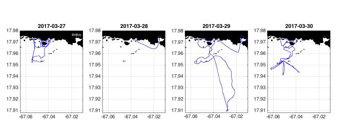
Figure 1: Cruise track (blue line) visited during the second cruise campaign from the 27th to 31st of March of 2017. The 18-hour diel sampling was conducted from the 28th to 29th of March at the west center of the Bio Bay.
Preliminary results indicated that areas particularly sensitive to ocean acidification are the Bio Bay and inshore channels (Figure 2) The results show that pCO2 concentrations in the inshore waters reached levels close to 1,000 uatm, which is significantly higher than the pCO2 of ~650 uatm projected for 2030 as the threshold value for tropical coral reefs (Yates & Halley, 2006). Results show the capacity of mangroves and seagrasses to modulate chemical and physical conditions of their environment (Figure 3). Results show that the mangrove and seagrass areas carbon system is more dynamic and complex than the “offshore” and reef waters (Figure 3).
Part of the second day incorporated an 18-hour diel sampling at the west center of the Bio Bay to investigate the relative influence of community metabolic processes at diurnal time scales. During the day surface seawater pCO2 concentrations are close to atmospheric equilibrium (~400 uatm). However, there is an apparent salinity stratification (Figure 4), where the pCO2 levels at the bottom are ~200 uatm higher compared with the surface water (Figure 5).
In addition, during the night, surface pCO2 levels significantly increased due to metabolic
processes (e.g. respiration) and vertical mixing. The salinity stratification breaks around midnight and surface pCO2 concentration equilibrated to ~600 uatm. The high pCO2 levels below this halocline could be due to the extensive remineralization of organic matter.
The two cruises showed different weather and oceanographic conditions (Figure 6). During the first cruise in fall (November 2016), surface seawater salinity values were generally low and variable> This was likely due to the influence of the Orinoco and Amazon River plumes into the eastern Caribbean waters as well as local precipitation events. The second cruise in spring (March 2017) showed higher salinity values and less variability. These preliminary results indicate that low seawater salinity waters may be conducive to high surface pCO2 and low Ωarg values.
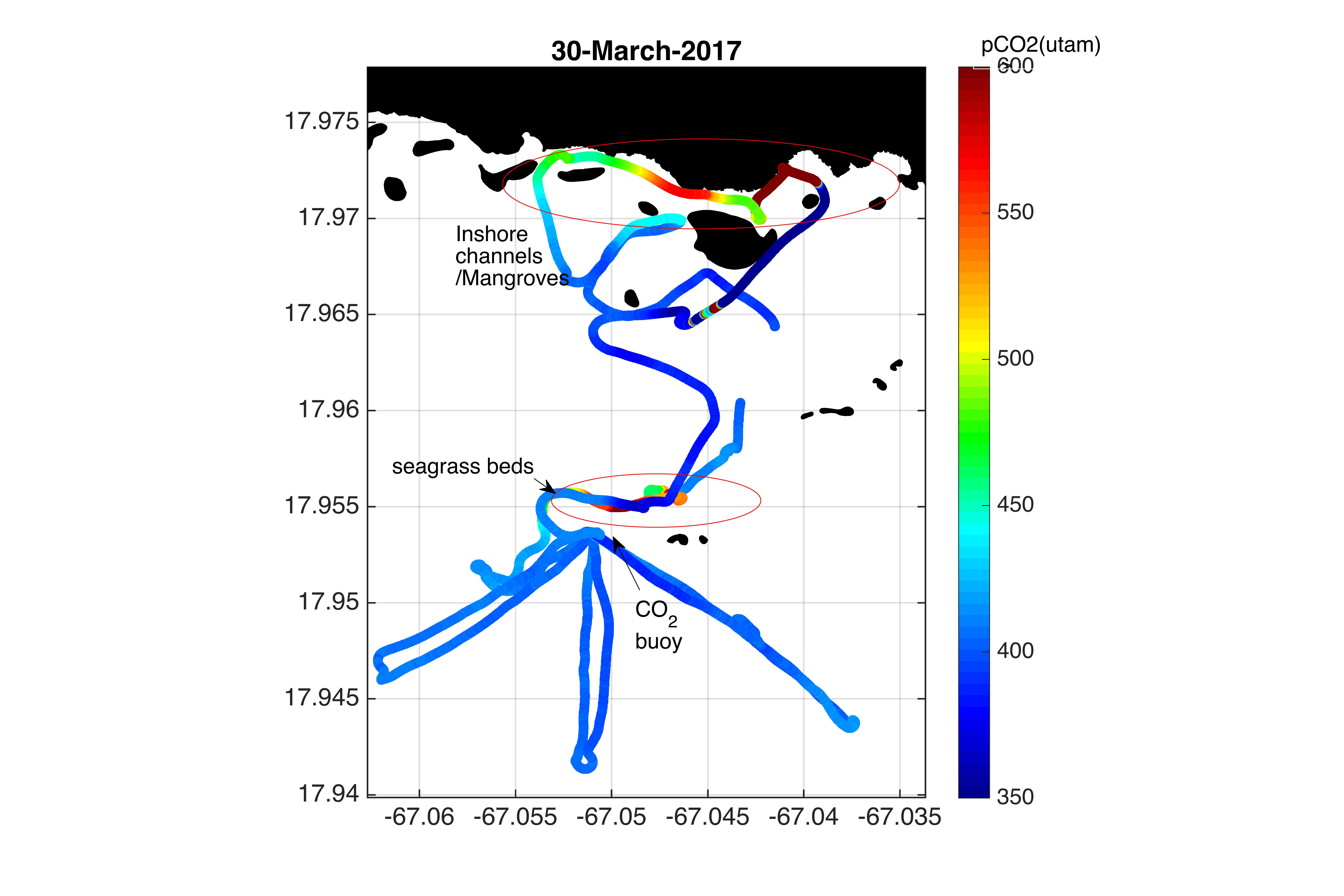
last day of the second cruise. Note the color bar on the outside right: high values are presented with red-yellow-green colors and low values with the blue colors.
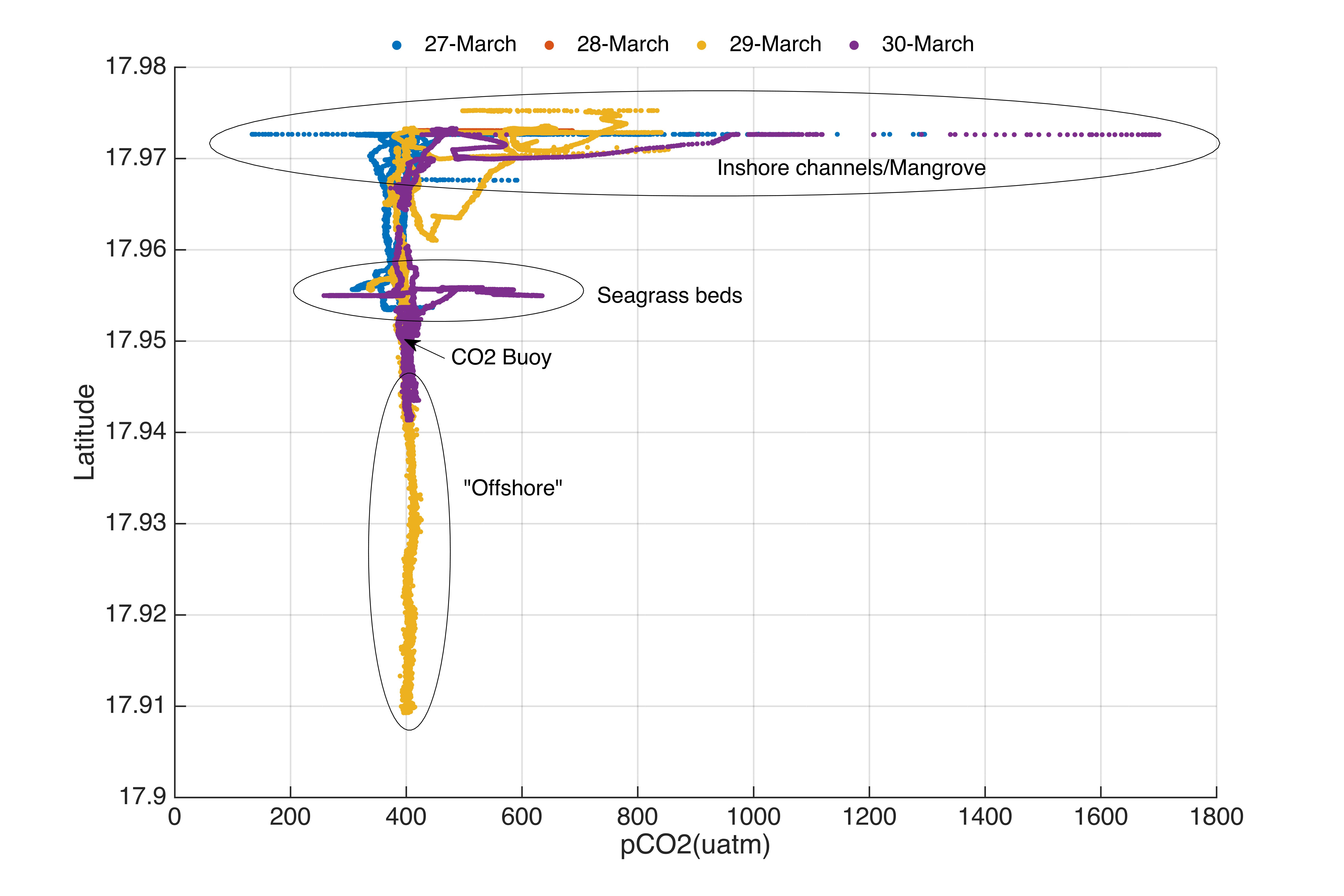
Figure 3: Surface seawater pCO2 (uatm) with latitude during the second cruise campaign from the 27-30 of March of 2017.
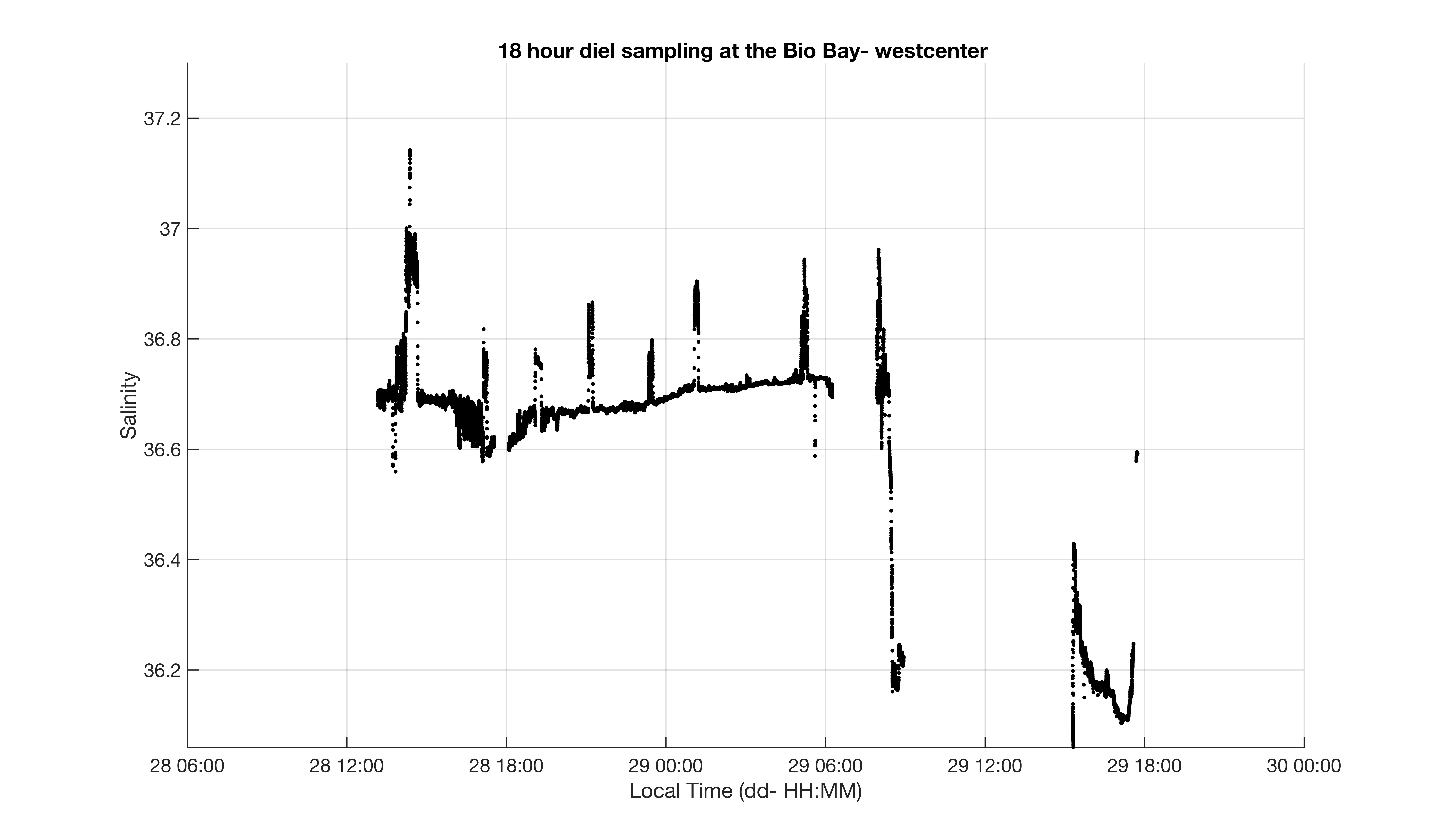
Figure 4: Salinity measurements taken during the 18-hour diel sampling at the Bio Bay. Bottom measurements were taken every two hours. (see figure 5 for more details).
Bottom - ~4m depth
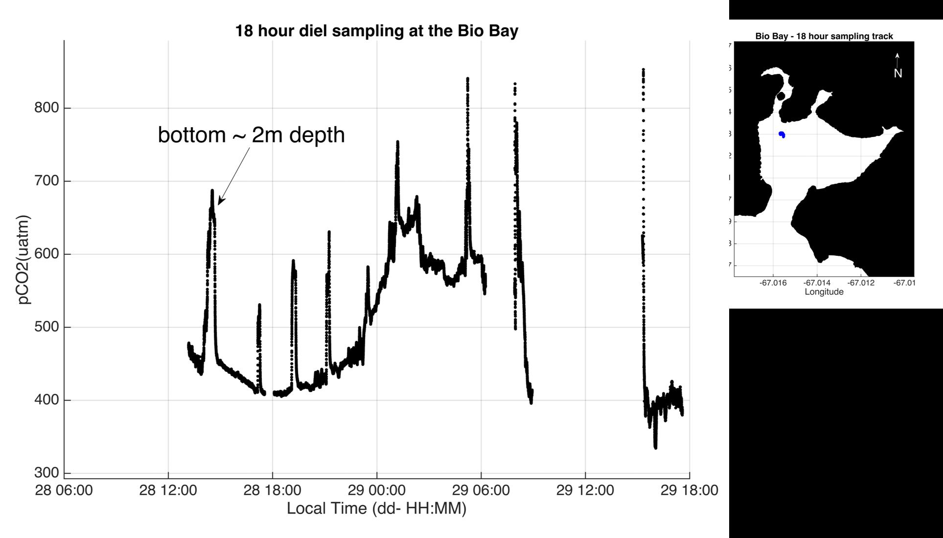
Figure 5: Seawater pCO2 concentration during the 18-hour diel sampling at the Bio Bay. Bottom measurements were taken every two hours. The map in the left shows the station (blue).
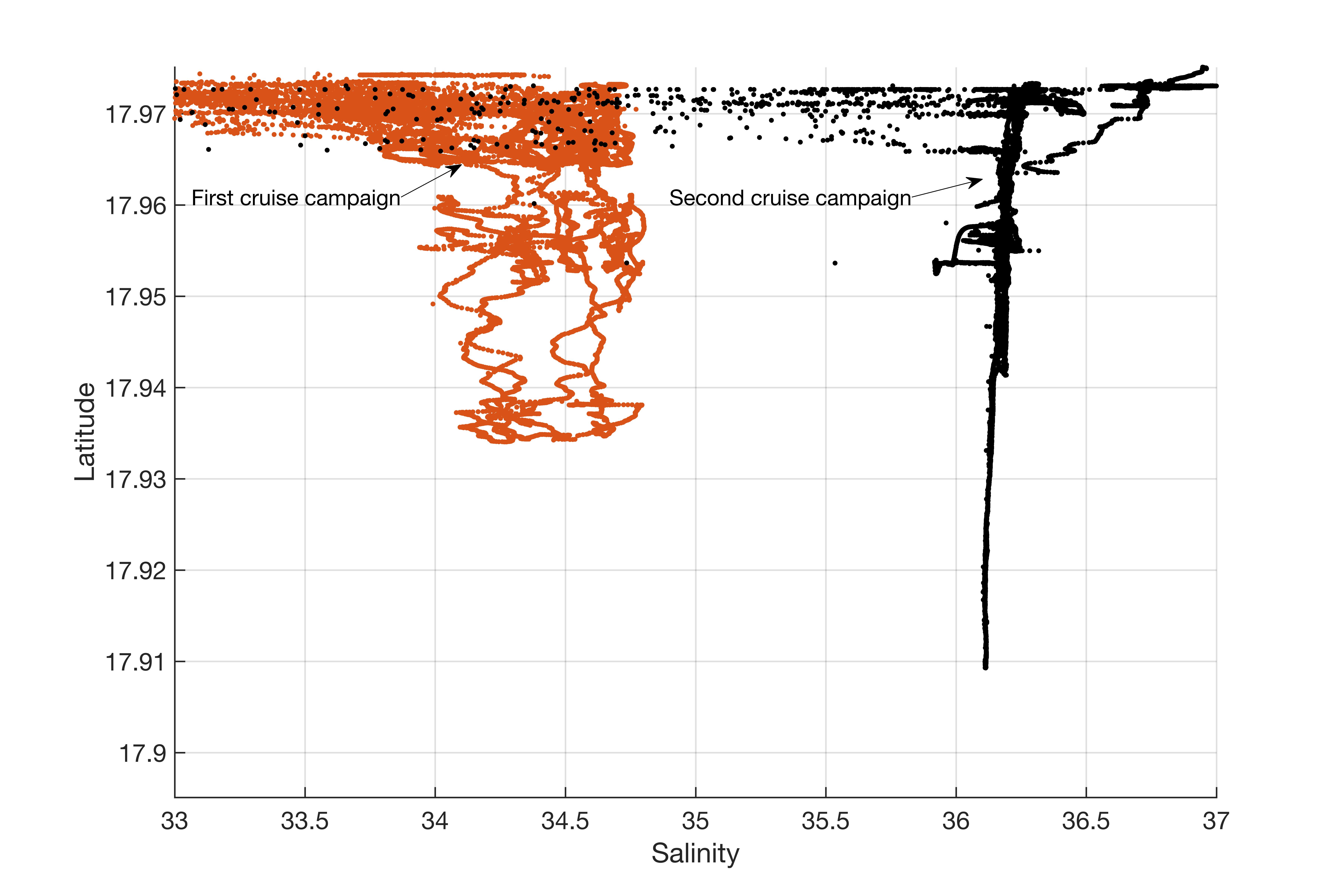
Figure 6: Salinity comparison between the two cruise campaigns. The orange dots show the November 2016 cruise sampling and the black dots the second cruise sampling on March 2017
Hydrodynamic characterization
• Patricia Chardón
• Jorge Capella
• David Carrero
• Adolfo González
• Milton Carlo (Captain)
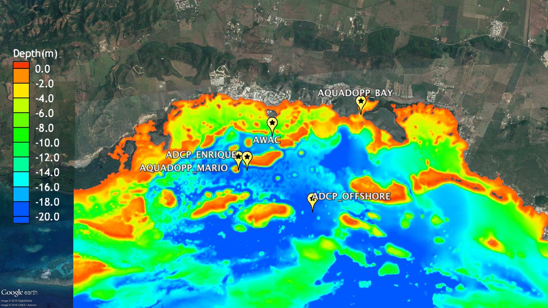
OCEANOGRAPHIC INSTRUMENTATION AND POSITIONS

A B


Date: March 27, 2017
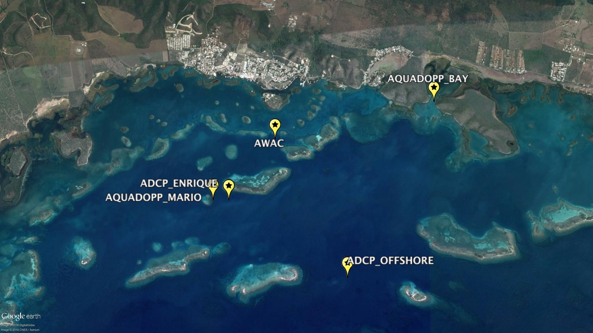
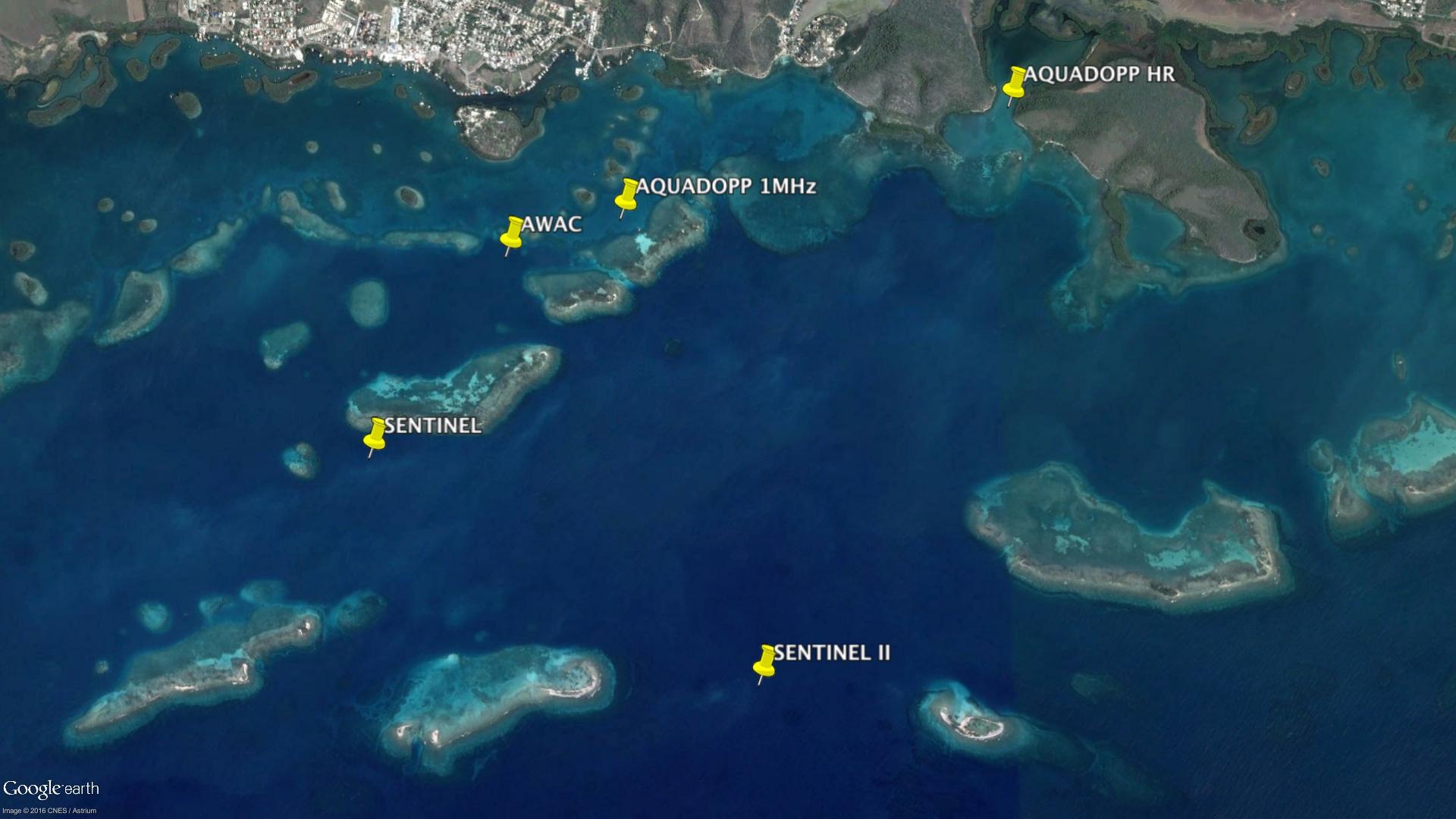
Figure 5: Hydrodynamic instruments used nd GPS positions on the first (A) and second (B) cruises. Red rectangle indicate the area were the drifters were deployed.
2. Methods
Surface seawater pCO2, chlorophyll fluorescence, colored carbon fluorescence, oxygen, salinity, temperature and beam attenuation were measured using a flow through system at 1Hz. During the second cruise the instrument presented problems and it was sent to the manufacturer. Discrete seawater samples for TA were taken instead on specific locations, with a total number of 57. The seawater samples were collected on 250 mL Biological Oxygen Demand (BOD) flasks and for spectrophotometric pH (DOE, 1994) and Dissolved Oxygen (Winkler method, for
details see Carpenter, 1965). The DIC and TA samples were poisoned with a saturated solution of mercuric chloride (HgCl2; <50 µl), to prevent biological alteration of the sample (Dickson et al. 2007), and shipped to UNH for analysis.
The 18-diel sampling was conducted at the west center of the Bio Bay and incorporated measurements at surface and bottom (~4 m). Seawater column was characterized using a CTD profiler. Seawater samples of particle organic carbon (POC) and dissolved organic carbon (DOC) were taken at surface and bottom. These will be used in conjunction with dissolved oxygen, TA and DIC to assess net primary production via commonly used algorithms (e.g. Behrenfeld and Falkowski 1997b; Behrenfeld et al. 2005).
3. Objectives
As stated in the original proposal, the objectives of the present project are as follows:
1. Characterize the variability of the carbonate chemistry and hydrodynamic conditions across different habitat types and temporal scales (diurnal to seasonal). Two cruises have been successfully completed with transects during the mornings (6am to 9am) and afternoons (3pm to 6pm) We covered an area of approximately 0.145 m2 Transects covered ~4km offshore and ~5 km from West to East, including the BioBay. The spatial surveys covered the inner (mangroves), middle (reef and seagrasses) and outer areas (deeper (> 15 m) reefs). ADCPs were positioned near all these areas and hydrodynamic conditions were characterized during the cruises. With these we can address the spatial, seasonal and diurnal variability of the carbonate chemistry.
2. Identify which is the net metabolic process leading each habitat type at different time scales using different approaches such as changes in total alkalinity (TA) and dissolved inorganic carbon (DIC) concentrations, optical properties, and metabolic rate measurement using “in situ” chamber incubation methods. Two samplings have been done to address metabolic processes at two important stations, the seagrasses and Bio Bay. We are currently in the process of analyzing these samples. We will be using TA, DIC and dissolved oxygen dynamics over diurnal cycles to estimate which metabolic process is leading the system.
3. Develop spatio-temporal maps of carbonate parameters (pH, DIC, TA, pCO2) for La Parguera coastal barrier system. The spatial mapping tool for presenting the results will be based on potential regulatory parameters such as pH, CO2 and Ω. This is currently in progress.
4. Other products
• No additional products yet.
5. List PI’s supported
Joseph Salisbury contributed 0.04 month to the project during the time period. He also participated in fieldwork under other NOAA and UNH funding.
Sylvia Rodríguez-Abudo contributed 0.7 month.
We also note in – kind donations of $2700 in boat charter from Julio Morel, volunteer services worth approximately $1500 and funding from Salisbury’s non-federal funds totaling ~$4200.
6. List students supported
Melissa Melendez, mm19@wildcats.unh.edu, PhD student at UNH Earth Sciences Department, Oceanography program. Sea Grant has paid $5273 during the reporting period.
David Thibault, dnw24@wildcats.unh.edu, Undergrad student at UNH Earth Sciences Department, Oceanography program. dnw24@wildcats.unh.edu, was paid $1250 during the reporting period for sample analysis.
Ella Cedarholm Undergrad student at UNH Chemistry Department was paid $700 during the reporting period for sample analysis.
7. List thesis and dissertations from students supported by the project.
o No available yet.
8. List presentations, technical reports and special awards Reports:
CMEP (2017) Caribbean Marine Climate Change Report Card 2017. (Eds. Paul Buckley, Bryony Townhill, Ulric Trotz, Keith Nichols, Peter A. Murray, Chantalle Clarke- Samuels, Ann Gordon, Michael Taylor). Commonwealth Marine Economies Programme, 12pp.
Puerto Rico’s State of the Climate 2014-2017 Report. Puerto Rico Climate Change Council, Puerto Rico Department of Natural and Environmental Resources. In progress.
U.S. Global Change Research Program Fourth National Climate Assessment (NCA4). Caribbean Regional Chapter. In progress.
Talks:
Garcia, E. Carbon dynamics in La Parguera Bio Bay. CARICOOS 2017 General Assembly, April 28, 2017. Rincon Beach Resort, Anasco, Puerto Rico.
Salisbury, J., Jonsson, B., Melendez, M. Perturbation and recovery of sea surface carbonate parameters related to extreme events. UNH SMSOE Graduate Research Conference, April 27, 2017.
Melendez, M., Salisbury, J., Morell, J., Rodriguez-Abudo, S. Are coastal barriers at risk? Implications for coastal communities. CARICOOS 2017 General Assembly, April 28, 2017. Rincon Beach Resort, Añasco, Puerto Rico.
Hunt, C.W. Coastal Alkalinity: What we know (and don’t know) about neutralizing Ocean Acidification. UNH SMSOE Graduate Research Conference, April 27, 2017.
Morell, J. M. and Meléndez, M. Sea Surface Temperature and Ocean Acidification trends in the Caribbean. 8va Reunion Cumbre del Consejo de Cambio Climatico de Puerto Rico, 07 abril de 2017, Hotel Intercontinental, San Juan.
Hunt, C.W., Salisbury, J.E., Vandemark, D., Mook, W., Sobin,J., Aßmann S. Expanding ocean acidification information for the Gulf of Maine and beyond. ASLO Aquatic Sciences Meeting. Feb 26-Mar 3, 2017. Honolulu HI, USA.
Sobin J, Meléndez M, Hunt C, Salisbury J, Fietzek P, Aßmann S. Advancing Environmental Monitoring Solutions for our World’s Oceans. 13th International Coral Reef Symposium, Honolulu, Hawaii; June 19-24, 2016
Morell J. M. and Meléndez M. Coastal Barriers at Risk: Ocean Acidification and Warming in the Caribbean. Coastal Ocean Observing 8th General Assembly and Stakeholders Council Meeting, Club Náutico de San Juan, Puerto Rico; April 27, 2016
Meléndez M and Salisbury J. Coastal Ocean Acidification at La Parguera, Puerto Rico characterization of the reef carbonate chemistry and the influence of metabolic processes on a coral reef. School of Marine Science and Ocean Engineering’s Graduate Research Symposium; April 21, 2016
Meléndez M and Salisbury J. Coastal Ocean Acidification at La Parguera, Puerto Rico characterization of the reef carbonate chemistry and the influence of metabolic processes on a coral reef. Graduate Research Conference; April 12, 2016
Meléndez M, Salisbury J, Morell J. M. Coastal Ocean Acidification at La Parguera CO2 Buoy. Puerto Rico Climate Change Council (PRCCC) Annual Meeting; April 07, 2016
9. Impact/Accomplishment Statement
This project has documented the spatial and diurnal variability of carbonate chemistry over different benthic communities and covered the inner, middle and outer areas of La Parguera natural barrier. It shows the mangrove and seagrass beds capacity to modulate the surface carbonate chemistry conditions compared with offshore and reef conditions. This project will help us identify the geographic distribution of surface carbonate chemistry which help in the identification of organisms sensitive to ocean acidification as the green calcareous alga Halimeda. This alga is common in the Bio Bay and inner channels and produce most of the carbonate sediments and emergent sand island in La Parguera.
It has also documented the influence of freshwater (rain events) on the carbonate saturation state triggering “dissolution events”. This information is necessary to estimate the tipping point in which dissolution and erosional processes are going to be dominant in these areas This project will help us identify areas sensitive to OA, including areas with carbonate sediments, calcareous plants and organisms and coral reef structures. With this information stakeholders, scientists, coastal managers, engineers, and community members will better evaluate management strategies and identify areas of resilience and vulnerability.
