Hyperspectral
Remote Sensing of Water Quality Parameters Impacting Coral Reef Health in Puerto Rico
Roy A. Armstrong, Ph.D.
Department of Marine Sciences
University of Puerto Rico at Mayaguez
Progress Report
October 1, 2016 to January 31, 2017
Introduction
Water quality is of great concern to coral reef managers in Puerto Rico and to most partners and stakeholders. There is an urgent need to monitor sedimentation and nutrients discharges into the coral reefs and the anthropogenic activities causing them. By the end of this project we anticipate having developed methods and algorithms that use hyperspectral in situ data to quantify water quality parameters in coastal waters. In addition, we anticipate developing satellite products using multispectral data for water quality indicators that can be related to coral reef status.
Tasks and Issues During the Reporting Period
Monthlyfielddatacollectionofopticalandwaterqualitydatahavebeencompletedduringthis reporting period. For the field sampling of optical measurements a Satlantic free-falling HyperspectralOpticalProfilerwasusedtomeasurethedownwellingirradianceandupwelling radiance at different sites in La Parguera and Guánica, southwestern Puerto Rico. These measurementsareusedforderivingtheattenuationcoefficientsofdownwellingirradiance(Kd) and the water-leaving radiance (Lw) for validation and calibration of satellite-derived ocean color products. These data have been made available to NOAA scientists for calibration/validation of the VIIRS water quality products Water samples were collected and processedtoestimateChl-a,CDOMandTSSconcentrationsatvariousstations.
Results and Findings
All water samples and optical data from the start of the project to this date has been processed. The sampled stations include a turbidity gradient that can be observed under high river flow conditions from inside Guanica Bay to the shelf edge. Stations in La Parguera represent coral reefs areas where long-term benthic characterization has been conducted. Other stations include Bioluminescent Bay and a deep-water station offshore from the bay.
Field Kd (490) values were obtained from the Satlantic spectroradiometer for the various sampling dates and represent an index of turbidity in the water column. The highest values of Kd 490 are from inside Guanica Bay (Figure 1). Chlorophyll a values were determined from water samples obtained at each station. Highest Chlorophyll a values are from Guanica Bay (Gua1) followed by Bioluminescent
Bay (LP11) (Figure 2). TSS values, as expected, are highest in Guanica Bay due to the Rio Loco river discharge into the bay (Figure 3). CDOM data was also obtained from discrete water samples and follow the same trends as the Chlorophyll a values (Figure 4).

Figure 1. Diffuse attenuation coefficient (Kd) values during four sampling dates at each station.

Figure 2 Highest Chlorophyll a values are from Guanica Bay (Gua1) followed by BioBay (LP11).

Figure 3 Total suspended solids during three sampling dates.

Figure4.CDOMvaluesduringsixsamplingperiods.
Satellite Data
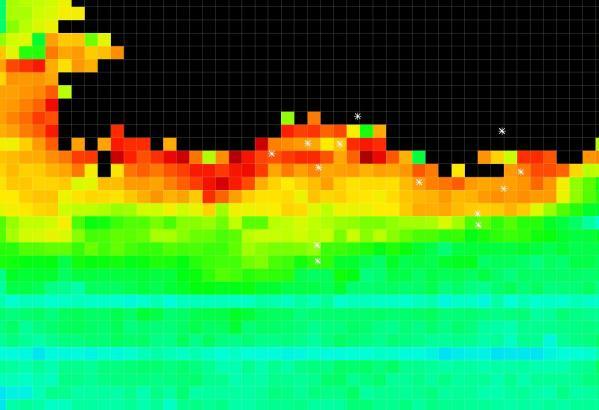
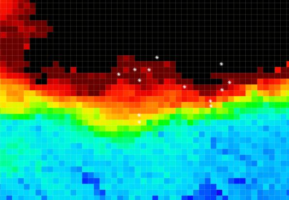
VIIRSoceancolordataat750mpixelsizewasusedtoshowtemporalandspatialpatternsin ChlorophyllinSWPuertoRico. Acomparisonofadry-season(February)andwet-season (October)imagesisshowninFigure5. MeanChlorophyllvalueswere2.46and5.56mg/m3for thedryandwetseasons,respectively.PrecipitationduringFebruary2016inMagueyesIsland, LaParguerawas2.2“and7.7”duringOctober2016.Fieldsamplingstationsareshownaswhite dotsintheimages.ThebottompanelsinFigure5areenlargedviewsfromSWPuertoRico.


Figure5. Dryseason(left)andwetseason(right)VIIRSChlorophyllimagesforthestudyarea.
Ourfieldsamplingdayscoincided,forthemostpart,withbi-weeklyLandsat-8satellitedata overpasses.SincethespatialresolutionofLandsat-8datais30m,itprovidesmoredetailof waterqualityparametersincoastalareas. Figure6isaLandsat-8imagefromDecember19, 2016forLaParguerashowingturbidityplumescausedbybottomresuspensionduringhigh windperiods.
AWorld-View-2HighResolution(2m)imageshowstheinfluenceofa“blackwater”event impactingtheinsularshelfareainLaParguera(Figure7).Satellitedatasuggeststhatthese “blackwater”eventsarecommoninthisareaandappeartooriginateinGuanicaBay. The frequencyandmagnitudeoftheseeventshaveneverbeenstudiedandcouldhaveanimpactin thecoralreefsofthearea. Ourfieldsamplingduringtheseeventswillhelpdeterminethe opticalandbiogeochemicalnatureoftheseblackwatermasses.

Figure6.December19,2016Landsat-8imageofLaParguerashowing sedimentresuspension.Thegreendotsarethefieldsamplingsites.

Figure7. World-View-2imageshowinga“blackwater”eventinLaParguera.
List of PI’s supported
Funding was provided to cover one summer month of the PI. A post-doc, Dr. William Hernandez was supported by NOAA.
Student Participation
Three students participated in this research that are funded by other projects. Omar Lopez is supported by NASA HARPOONS while Myrna Santiago and Suhey Ortiz are supported by NCAS and CREST projects, respectively (Table 1). Category
Table 1. Students supported. *No students were directly supported by Sea Grant.
