OUTCROP Newsletter of the Rocky Mountain Association of Geologists
Volume 75 • No. 9 • September 2026
SUMMIT SPONSORS Platinum Sponsor
Silver Sponsors
OUTCROP | September 2026
2
Vol. 75, No. 9 | www.rmag.org
OUTCROP Newsletter of the Rocky Mountain Association of Geologists
730 17th Street, B1, Denver, CO 80202 • 720-672-9898 The Rocky Mountain Association of Geologists (RMAG) is a nonprofit organization whose purposes are to promote interest in geology and allied sciences and their practical application, to foster scientific research and to encourage fellowship and cooperation among its members. The Outcrop is a monthly publication of the RMAG.
2026 OFFICERS AND BOARD OF DIRECTORS
RMAG STAFF
PRESIDENT
2nd VICE PRESIDENT-ELECT
EXECUTIVE DIRECTOR
Sandra Labrum slabrum@slb.com
Ashley Castaldo acastaldo@slb.com
Bridget Crowther bcrowther@rmag.org
PRESIDENT-ELECT
SECRETARY
LEAD EDITOR
Ali Sloan ali@4jresources.com
Stephanie Forstner sforstner@diagenyx.com
Danielle Robinson danielle.robinson@dvn.com
1st VICE PRESIDENT
TREASURER
Nate La Fontaine nlafontaine@sm-energy.com
Walter Nelson wnelson@integratedenergyresources.com
CONTRIBUTING EDITORS
1st VICE PRESIDENT-ELECT
TREASURER-ELECT
Danielle Robinson danielle.robinson@dvn.com
Dan Bassett dbassett@sm-energy.com
Nate La Fontaine nlafontaine@sm-energy.com
2nd VICE PRESIDENT
COUNSELOR
Lisa Wolff lwolff@bayless-cos.com
John Benton jhbenton@mines.edu
Bobby Schoen bschoen@sm-energy.com
ADVERTISING INFORMATION
Rates and sizes can be found on page 42. Advertising rates apply to either black and white or color ads. Submit color ads in RGB color to be compatible with web format. Borders are recommended for advertisements that comprise less than one half page. Digital files must be PC compatible submitted in png, jpg, tif, pdf or eps formats at a minimum of 300 dpi. If you have any questions, please call the RMAG office at 720-672-9898. Ad copy, signed contract and payment must be received before advertising insertion. Contact the RMAG office for details. DEADLINES: Ad submissions are the 1st of every month for the following month’s publication. The Outcrop is a monthly publication of the Rocky Mountain Association of Geologists DESIGN/LAYOUT: Nate Silva | n8silva.com
Vol. 75, No. 9 | www.rmag.org
3 3
Elijah Adeniyi eadeniyi@slb.com
RMAG CODE OF CONDUCT RMAG promotes, provides, and expects professional behavior in every engagement that members and non-members have with the organization and each other. This includes respectful and inclusive interactions free of harassment, intimidation, and discrimination during both online and in-person events, as well as any content delivered by invited speakers and instructors. Oral, written or electronic communications that contain offensive comments or demeaning images related to race, color, religion, sex, national origin, age, disability, or appearance are not appropriate in any venue or media. RMAG reminds members of the diversity and mission statements found on our website. Please direct any questions to staff@rmag.org.
Outcrop | September 2026 OUTCROP
2026 NETWORKING EVENTS MARK YOUR CALENDARS
AUGUST SEPTEMBER OCTOBER NOVEMBER DECEMBER
5 2 7 4 2
LUNCHEON WEDNESDAY 12PM
HAPPY HOUR TUESDAY 4PM
FOR MORE INFORMATION ON THESE EVENTS AND TO SEE WHAT ELSE IS COMING VISIT: www.rmag.org/events
JULY AUGUST
28 25
SEPTEMBER OCTOBER DECEMBER
29 27 1
OUTCROP Newsletter of the Rocky Mountain Association of Geologists
CONTENTS FEATURES
ASSOCIATION NEWS
6 2027 RMAG Summit Sponsorship Packet
2 RMAG Summit Sponsors 4 RMAG Networking Events
14 Lead Story: RMAG On the Rocks, Late Cenozoic Geology of the Upper Arkansas Valley Field Trip
11 RMAG Shortcourse: Practical Python For Earth Scientists
24 RMAG On the Rocks: Fishing Trip to the Early Eocene, Kemmerer, Wyoming
13 RMAG Shortcourse: From Planning To Completions, Life Cycle Of A Well In StarSteer
DEPARTMENTS
21 Join On-The-Rocks This Summer! 23 RMAG New Member Happy Hour 31 Mowry Formation Symposium 36 Mountain Geologist— Seeking Editor 40 RMAG Foundation announces the Dickinson Grant
COVER PHOTO
10 RMAG August 2026 Board Of Directors Meeting
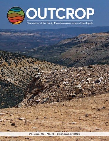
View to the northeast from FBM Location A, the famous Tynsky quarry where we conducted our fishing expedition. In the distance, the red fluvial sediments of the Paleocene Wasatch Formation are capped by the light-colored early Eocene marls from Fossil Lake. Photo by Ronald L. Parker.
12 President’s Letter 20 September Hybrid Lunch Talk: Zane Jobe 22 October Hybrid Lunch Talk: Callum Thurley 38 In The Pipeline 42 Outcrop Advertising Rates 42 Welcome New RMAG Members! 45 Calendar 45 Advertiser Index
Vol. 75, No. 9 | www.rmag.org
5
OUTCROP | September 2026
SUMMIT SPONSORSHIP infographic link
OUTCROP | September 2026
6
2 0 2 7 Vol. 75, No. 9 | www.rmag.org
September 1, 2026 Geoscience Community: On behalf of the Rocky Mountain Association of Geologists, thank you to every Summit Sponsor and Event Sponsor who supported us this past year. Sponsors like you are the foundation of this organization, and everything RMAG accomplishes for the geoscience community starts with your generosity. In 2026, RMAG was proud to host a dynamic lineup of events, including an upcoming Symposium diving into the Mowry Formation. Members explored geologic wonders across the state, from the kimberlites to South Park and the Arkansas River Valley. We launched the Rocky Mountain Discovery Series, sitting down with senior statesmen of the industry to learn what shaped their careers and their success. Volunteers shared their passion for geoscience with students across the region through classroom visits and community festivals, and members connected outside the office through monthly lunches, coffees, happy hours, and our annual Golf Tournament. Every one of these programs was made possible by the sponsors who fund them. Looking ahead, 2027 brings exciting opportunities for RMAG and our partners, and your support is what makes each one possible. We'll open the year with a State of the Industry luncheon, diving into research shaping our field and hearing directly from the ECMC on where the industry is headed. The 2027 North American Helium and Hydrogen Conference is coming together, and our 101 series continues, sharing industry knowledge with our newest members while refreshing the expertise of working professionals. Networking in 2027 will include our regular happy hours, plus Rockbusters, the Golf Tournament, and more chances to connect with your colleagues. With your support, RMAG members will keep sharing the wonders of earth science through community and school outreach, and we'll continue our publication efforts, including the monthly Outcrop newsletter and the peerreviewed Mountain Geologist journal. As a Summit Sponsor, your commitment gives your employees access to every RMAG event, from our educational programs to the camaraderie of the Golf Tournament. RMAG also recognizes Summit Sponsors through in-person signage at events, on our website, in our publications, and across social media. Thank you to our current Summit Sponsors; we hope to count on your continued support in 2027. And if you're not yet sponsoring, there's no better time to join us. RMAG relies on sponsorship to keep this community running: it directly fuels the education, networking, and professional development opportunities we offer throughout the Rocky Mountain region. Simply put, our sponsors are vital to our success, and to the success of the geoscience community we all share. We invite you to review our sponsorship packages and find the level that best aligns with your company's goals. Whether you choose to become an annual Summit Sponsor or support a single event, your partnership will directly advance geoscience education and keep our community thriving. Ready to become a Summit Sponsor? Contact RMAG Executive Director Bridget Crowther at bcrowther@rmag.org or 720-672-9898 to discuss opportunities and reserve your sponsorship for 2027. Sincerely, Ali Sloan 2027 RMAG President
Bridget Crowther RMAG Executive Director
P: (720)672-9898 staff@rmag.org www.rmag.org
Vol. 75, No. 9 | www.rmag.org
730 17th Street, B1 Denver, CO 80202
7
OUTCROP | September 2026
RMAG ANNUAL
SUMMIT SPONSORSHIP
PLATINUM, GOLD, & SILVER
SPONSORSHIP LEVEL
PLATINUM
GOLD
SILVER
$10,000
$5,000
$2,500
$835
$417
$208
$10,000
$5,000
$3,000
4
2
1
Contribution Level Monthly Cost
Benefits Value
RMAG MEMBERSHIP Active or Associate Membership in the Association for employees
RMAG WEBSITE BENEFITS Company Logo on Summit Sponsor Page of www.rmag.org
Large Logo & Link
Articles and Ads on special Advertisers web page
4 articles & 4 large ads
Medium Logo and Link 2 articles & 2 medium ads
Small Logo and Link 2 small ads
PUBLICATION ADVERTISING 12 months of Outcrop advertising: To receive 12 full months, company logos and ad art must be received no later than the 20th of the month in which you register. The Outcrop (receive benefits for 12 issues, monthly online publication
Full page ad
2/3 page ad
1/2 page ad
Company Logo listed as an annual Sponsor in The Outcrop
Large Logo
Medium Logo
Small Logo
EVENT ADVERTISING Sponsorship will be acknowledged as part the summit sponsors at all RMAG Events. Additional Sponsorship Opportunities will be available for all RMAG Events. Company Logo Looping in Slide Decks
Large logo individual Slide
Medium logo
Small Logo
Company Logo on Summit Sponsor Signage at all events
Large logo
Medium Logo
Small logo
RMAG EDUCATION EVENTS Registration points are cumulative and can be used for Symposiums or Short Courses. For example a Platinum Sponsor can send 4 people to the upcoming symposium conferences and register for 2 short courses. Total Educational Tickets
6
3
1
RMAG SOCIAL EVENTS Registration Points are cumulative and can be used for any social event. For example, 1 point means 1 golfer, or 1 registration for Rockbusters. *2 points can be used for a golf hole if that makes more sense for your company. Total Social Event Tickets
8
4
2
3
2
RMAG LUNCHEONS & FIELD TRIP TICKETS Registration Points are cumulative for luncheons or one day field trips. Total Luncheon & Field Trip Tickets
5
For all event tickets please contact the RMAG office at staff@rmag.org to use your spots.
OUTCROP | September 2026
8
Vol. 75, No. 9 | www.rmag.org
RMAG 2027 SUMMIT SPONSORSHIP Payment Options
All sponsor benefits event tickets follow RMAG event registration deadlines. All benefits end 12 months after registration. RMAG 2027 ANNUAL SUMMIT SPONSOR OPPORTUNITIES Platinum Sponsor Gold Sponsor Silver Sponsor
Summit Sponsorship benefit term is for 12 months! Specify type of payment on signed form, and send logo and advertisements to staff@rmag.org Company: Company Representative: Address: City:
State:
Phone:
Zip Code: Email:
Payment Method:
ACH
Credit Card
Credit Card Information: Select Card: AMEX
Check VISA
Mastercard
Discover
Name as it appears on Credit Card: Credit Card #: Expiration Date:
Security Code:
Signature: ACH: contact the RMAG office at staff@rmag.or for directions. Mail Checks payable to RMAG: Rocky Mountain Association of Geologists (RMAG) 730 17th Street, B1 Denver, CO 80202
RMAG events are subject to change. Cancellation or rescheduling of events does not give the sponsor the right to refund. Summit Sponsors will receive benefits at any new events added into the RMAG schedule.
Thank you for your generous support! P: (720)672-9898 staff@rmag.org www.rmag.org
Vol. 75, No. 9 | www.rmag.org
730 17th Street, B1 Denver, CO 80202
9
OUTCROP | September 2026
RMAG AUGUST 2026 BOARD OF DIRECTORS MEETING By Stephanie Forstner, Secretary sforstner@diagenyx.com
OUTCROP | September 2026
reason to finally learn that software your colleagues keep talking about, this may be your moment. The Membership Committee has also had a busy summer. Our August Golf Tournament sold out with 135 players and raised $10,000 in sponsorships. The Rocky Mountain Discovery Series, launched in July with Rob Sterling, brought together about 20 people for its first event and, importantly, attracted a somewhat different crowd than our traditional luncheons. Donna Anderson will be our next featured geoscientist on November 12. We are also planning a New Member Happy Hour at New Terrain September 29, open to everyone. If you see a new face there, introduce yourself. That’s the whole point. Our On the Rocks calendar is full through the fall. The South Park Basin trip was a success with 21 attendees, and upcoming trips include Clear Creek gold panning on September 18 and the Picketwire Dinosaur Trackway on September 26–27. Join Outreach October 10th for Girl Scout Day at Dinosaur Ridge and October 11th at the Museum of Nature and Science. Finally, RMAG is seeking new volunteers to step into future Board leadership roles. We are currently seeking a President-Elect, VP of Publications, VP of Continuing Education, Treasurer-Elect, and Counselor. Board service is a meaningful way to help shape the organization, but it is also a pretty good way to meet people you might otherwise only recognize from their email signature. If you’re interested, or know someone who would be a good fit, please reach out. As summer winds down, I hope you’ll find a way to join us this fall, whether that’s over a lunch, at a happy hour, in a classroom, or somewhere considerably dustier. RMAG is at its best when our members show up.
Do you feel that chill in the air!? Fall is here and RMAG is heading into one of our busiest seasons, with technical courses, field trips, networking events, and plenty of opportunities to connect with fellow members. The Board of Directors met on August 19 to catch up after the summer, hear from our committees, and look ahead to the busy months ahead. Financially, RMAG remains in a healthy position. The Board also approved a transfer from our investment account to support normal operating cash flow. The Continuing Education Committee has a lot in the works. The Mowry Symposium on November 5 is shaping up with 14 potential talks, and the committee is filling out the fall calendar with several technical courses. September brings Python for Earth Scientists and a ROGII StarSteer course, followed by Geomark 101 in October. If you’ve been waiting for a
10
Vol. 75, No. 9 | www.rmag.org
& COLORADO SCHOOL OF MINES AAPG STUDENT CHAPTER
101 SHORTCOURSE SERIES
PRACTICAL PYTHON FOR EARTH SCIENTISTS SATURDAY SEPTEMBER 12, 2026 COLORADO SCHOOL OF MINES Practical Python for Earth Scientists is a hands-on course intended to introduce basic concepts and give working examples of python code that can be used in daily geoscience workflows. No prior knowledge of python or other programming languages is necessary to attend this course. Topics covered: Basic python syntax Loops, functions, and classes Sorting and plotting data (pandas and matplotlib) Local python installation (optional, requires admin rights) Geospatial data (e.g., shapefiles) Well logs (las files) Data scraping Machine-learning (unsupervised and supervised methods)
Register at rmag.org/python $50 Members Students Free - Email staff@rmag.org Vol. 75, No. 9 | www.rmag.org
11
OUTCROP | September 2026
PRESIDENT’S LETTER By Sandra Labrum slabrum@slb.com
The Importance of Community school was the direction I wanted to take, but her encouragement opened a door that ultimately led me to SLB, where I have now been for almost 15 years. At SLB, I’ve had some incredible mentors, both as managers and as colleagues. One of my first managers encouraged me to give sales a try when I was feeling stuck doing the same technical work. Sales was not something I had ever considered for myself, but with his encouragement, I decided to take a chance. As it turns out, making that jump was one of the best things I could have done for my career. Looking back, my career has been shaped by a series of people who saw an opportunity for me before I saw it for myself. I think we all need a little nudge from time to time. That is one of the things I love about professional societies. They create opportunities for those connections to happen. Sometimes networking means making a connection that leads directly to a new job or collaboration. But just as often, it means being exposed to a career path, an idea, or a new area of geology that you didn’t even know existed. You never know who you are going to meet at a talk, a field trip, a happy hour, or a committee meeting and you never know when one conversation might change the direction of your career. So, if you’re feeling a little stuck in your current routine, curious about what other geologists are working on, or simply looking for an excuse to get out and meet some new people, come to an RMAG event. Bring a colleague, introduce yourself to someone you don’t know, or join a committee. Maybe you’ll meet someone who introduces you to a new idea. Maybe you’ll discover a career path you hadn’t considered. Or maybe you’ll be the person who gives someone else the little nudge they need. You never know where one conversation might lead. —Sandra
This year, I attended IMAGE in Houston for the first time in several years. Every time I go to a large conference like IMAGE, I’m reminded of two things: just how many people there are in our geoscience community and, somehow, just how small that community can feel. I ran into people I hadn’t seen since graduate school. I reconnected with former colleagues, caught up with old friends, and met people whose paths I had never crossed before. It was wonderful to see so many familiar faces, and it got me thinking about the importance of community and the people who shape our careers. I’ve been incredibly fortunate throughout my career to have had several people step in at just the right time and help guide me. When I started college, I had no idea what I wanted to do, and geology certainly wasn’t at the top of my list of potential majors. I ended up in Geology 101 simply to fulfill a science requirement. Somewhere along the way, my professor encouraged me to consider geology as a major. She eventually became my advisor, and that one conversation helped set me on a career path I hadn’t even considered. My first manager after college was another important influence. She encouraged me to consider going back to graduate school and even nominated me for a scholarship. At the time, I wasn’t sure that graduate
John C. Webb
Consulting Geologist Stratigraphy, Sedimentology and Petrography of Clastic and Carbonate Systems
Reservoir Characterization Petroleum, SWD, CCUS, Geothermal
Louisville, Colorado Johnwebb20@comcast.net 303.917.0644
OUTCROP | September 2026
12
Vol. 75, No. 9 | www.rmag.org
101 SHORTCOURSE SERIES
FROM PLANNING TO COMPLETIONS: LIFE CYCLE OF A WELL IN STARSTEER WEDNESDAY SEPTEMBER 16, 2026 DENVER EARTH RESOURCE LIBRARY
This introductory course provides an overview of how StarSteer supports the complete lifecycle of a well, from initial planning through geosteering and into completions. Participants will be introduced to the core tools and workflows used throughout each phase of development, gaining a foundational understanding of how data flows through the software and how StarSteer supports day-to-day operations. Course Goals: Navigate the StarSteer interface with confidence. Understand how StarSteer supports each stage of the well life cycle. Recognize the primary workflows used during planning, drilling, and completions. Perform basic data import and export tasks. Understand how geologic and operational data are managed within StarSteer. Topics Covered: Introduction to the StarSteer interface Well planning fundamentals Importing planning and operational data Introduction to geosteering workflows
Creating and managing geologic tops Updating maps during drilling operations Basic project and data management Importing and exporting project data Overview of completion data workflows Best practices for working within StarSteer
Register at rmag.org/shortcourse $50 Members/ $75 Non-Members
Presented by: Vol. 75, No. 9 | www.rmag.org
13
OUTCROP | September 2026
LEAD STORY
RMAG ON THE ROCKS
LATE CENOZOIC GEOLOGY OF THE UPPER ARKANSAS VALLEY FIELD TRIP JUNE 26, 2026 By Ralf Topper
FIGURE 1
OUTCROP | September 2026
14
Vol. 75, No. 9 | www.rmag.org
He started with the bigger picture of the landscape developed with the Eocene Rocky Mountain Erosional Surface, when upland ranges were eroded and adjacent basins filled. Following this erosional episode, Oligocene igneous activity covered the region in volcanic deposits and airfall debris and ash. The Miocene brought the development of the transcontinental Rio Grande Rift system accompanied by uplift of the Sangre de Cristo and Sawatch Ranges, both hosting magnificent 14,000 ft peaks. The major bounding faults are on the east side of the San Luis Valley and on the west side in the Arkansas River Valley with Poncha Pass acting as the transform hinge and accommodation zone. Tectonic uplift continued until the onset of glaciation and climate cooling. Globally, continued extensive volcanic activity between 5-1.5 mya most likely contributed substantially to producing cooler Pleistocene climates and eventually the major Pleistocene Ice Ages beginning <1.5 Ma. Cal presented 5 million years of climate change data from sediment cores. The Pliocene to early Pleistocene represented a dominantly warm, dry period during which the pre-glacial
T
WENTY RMAG MEMBERS
gathered at the top of Fremont Pass, across from the Climax Mine, on Friday morning June 26th as Cal Ruleman, U.S. Geological Survey geologist with the Geosciences and Environmental Change Science Center, began his presentation of 1.5 million years of tectonics, the Central Colorado Icefield, and the formation of the Arkansas River. Within minutes, it became apparent that Cal’s knowledge of the late Cenozoic geology and geomorphology of the upper Arkansas River valley was impressive. His ease at conveying that knowledge and the geologic concepts central to the subject matter of this On-the-Rocks field trip totally engaged his audience. With a series of posters attached to the mine’s steel locomotive and ore carts display, Cal discussed how recent geomorphic investigations aided by Quaternary geochronologic and thermochronologic tool development have better constrained our understanding of Rocky Mountain landscape evolution resulting from Neogene tectonomagmatism and Pleistocene glacial and glaciofluvial processes (Figure 1).
FIGURE 2
Vol. 75, No. 9 | www.rmag.org
15
OUTCROP | September 2026
LEAD STORY: UPPER ARKANSAS VALLEY FIELD TRIP
OUTCROP | September 2026
(pre-glacial/non-glacial), dated at 1.97 Ma and capped by pre-Bull Lake glaciofluvial gravel/outwash. This exposure along the railroad tracks is characterized by reddish brown, weathered and oxidized, angular to subrounded pebble to cobble gravels in a sandy silt and clay matrix and is the most prominent, highest surficial deposit grading across the Leadville area. The similarity of this deposit to exposures of basin-fill Dry Union Formation to the south led Cal and his coworker Karl Kellogg to interpret the Malta Gravel to be a deposit within the upper part of the Dry Union. We then went to the dam area of Twin Lakes Reservoir for lunch and discussion of the tectonism and deposition associated with Rio Grande rifting. Cal discussed the numerous, mostly down-to-the-east, normal faults bounding the west side of the upper Arkansas River valley comprising the Sawatch Range fault zone. This north-northwest-trending fault zone extends from Poncha Pass to Tennessee Pass, and is subdivided at Granite, CO into the Northern and Southern Sawatch fault zones. The Upper Arkansas Valley drains the Sawatch Range on the west and the Mosquito Range on the east. The bounding walls of the valley are mostly Precambrian granite, and the valley floor consists of 1,000+ meter thick Neogene Dry Union Formation sediments with a veneer of Quaternary alluvium. The Arkansas River, as we know it today, did not form until 1.3 Ma, after deposition of the Nussbaum Gravel and initiation of headward incision across the Royal Gorge and upstream into the hinterland of the Southern Rocky Mountains. The lateral and terminal moraines of the Lake Creek glacier were evident at this stop (Figure 4). The Twin Lakes area contains moraines of older Bull Lake gravels and Pinedale gravels. The Lake Creek glaciers did not dam the Arkansas River but probably pushed the river eastward out of its channel as the modern Arkansas River cuts into the granite of the Mosquito Range, even though the soft sediments of the Dry Union Formation are only a few hundred feet to the west. Field studies suggest that the Pinedale glaciers were receding from about 14.4 to 12.6 ka, with deglaciation rates of about 1 meter per year. Cal discussed the Clear Creek and Pine Creek glacio-fluvial flood deposits that we would drive by just south of Granite and how those glaciers flowed across the
Malta gravel (1.97 mya) was deposited in the upper Arkansas River Valley. The major glaciation started approximately 1.4-1.2 mya, and the Central Colorado Icefield covered all the upland areas generally above 8,000 feet in elevation (Figure 2). The middle to late Pleistocene saw deep-canyon incision and headward erosion and incision of the river systems associated with the most recent ice age (~1.5 Ma-13.5 ka). The Central City Gravel (1.4 Ma) is the oldest recognized, first big glacial deposit emanating from the Continental Divide and deposited along Clear Creek in the Front Range on the east side of the Continental Divide. Along the Front Range and Southern Rocky Mountain Front, the Nussbaum Gravel (1.3 Ma) was deposited across the Great Plains as a product of the 1.4 Ma Central City Gravel glacial episode. The period from 480-370 ka produced the longest, coldest, and wettest glacial episode (marine oxygen isotope stage 12) followed by the longest, hottest, and driest interglacial period (marine oxygen isotope stage 11) in the Pleistocene. Cal attributed major glaciofluvial erosion to this episode with average glacial erosion rates exceeding 0.5mm per year. From Fremont Pass, the group drove to the Pinedale terminal moraine at Turquoise Lake. The youngest and most extensive glacial deposits in the Upper Arkansas River Valley are from the Pinedale glaciation (about 31–12 ka). Moraines of Pinedale age have sharper crests and more hummocky surface morphology than those of older glacial periods. Cal described how boulders emplaced by glaciers and exposed to cosmic rays were candidates for cosmogenic age dating. Dates acquired at this locale produced an age of 21,500 years. The area around Turquoise Lake saw multiple glacial pulses with the last episode melting away by 13,000 years ago. RMAG field trip coordinator Ralf Topper took the opportunity to educate the group about the storage and conveyance aspects of Turquoise Lake in relation to two major Colorado transmountain, trans-basin water projects: the Homestake Water Project and the Fryingpan-Arkansas Project. Our second stop was behind the Shell gas station/convenience store near the intersection of State Route 300 and Highway 24 to view the type section for the Malta Gravel (Figure 3). The Malta Gravel is considered the uppermost Dry Union Formation
16
Vol. 75, No. 9 | www.rmag.org
LEAD STORY: UPPER ARKANSAS VALLEY FIELD TRIP
FIGURE 3
Vol. 75, No. 9 | www.rmag.org
FIGURE 4
discussion of the Homestake and Fryingpan-Arkansas water projects. The Mount Elbert Conduit conveys project water from Turquoise Lake to the Mount Elbert forebay at Twin Lakes. All conduit flow is used to generate electricity at the Mt. Elbert power plant. The power plant is a pumped-storage facility that has two 100-megawatt turbine generators that can be reversed and used as 340,000 horsepower pumps. Project water stored in the reservoir is released to Lake Creek, a tributary of the Arkansas River, for storage in Pueblo Reservoir. Additionally,
Arkansas River, grinding into the eastern granitic wall, creating an ice-dam that impounded the river. These outburst flood deposits were first recognized by Glenn Scott and later more fully investigated by Keenan Lee of Colorado School of Mines. The glacial impact scar produced a distinctive unusual landform of a clearly defined, very steep, concave cliff of less weathered granite cut into the wall on the east side of the valley. This glacial impact scar was coined a “whamout” structure by Keenan Lee. The glacial lakes produced by the ice dams would periodically break through the dam catastrophically. Three major floods have been recognized: two during the Pinedale glaciation and an older one whose age is constrained by the age of the Lava Creek B ash (639 ka). These catastrophic floods carried huge amounts of glacio-fluvial sediments and plucked out large boulders from the surrounding granitic walls carrying them miles downstream. The estimates of peak discharge are between 21,000 and 65,000 cubic meters per second. At the Twin Lakes stop, Ralf continued his
17
OUTCROP | September 2026
LEAD STORY: UPPER ARKANSAS VALLEY FIELD TRIP for the valley. Glacial outburst boulders lie on top of the Proterozoic rocks and the Dry Union in this area. The Lava Creek B ash thus provides a maximum age for the overlying boulders of pre-Bull Lake glaciations. Returning to CR 371, we continued south to Buena Vista to view some very large flood boulders deposited in the valley associated with the youngest Pinedale flood event. For stop #5, we continued south on Hwy 285 to Nathrop, turning west on CR 162 to drive up the glaciated valley of Chalk Creek. Turning on CR 270 near Mount Princeton Hot Springs, we stopped behind the Ray Lewis power substation to view a pre-Bull Lake deposit. This deposit consists of boulder and cobble gravel deposited downslope from pre-Bull Lake till. It is characterized by deeply weathered, rounded cobbles. Much of the pre-Bull Lake till is likely buried beneath younger glacial deposits as cold and warm climatic cycles prior to 900 ka were of lower amplitude and much shorter duration. Marine oxygen isotope records show only two glacial episodes (MIS 12
Colorado Springs and the City of Aurora pick up their Homestake project water from the Arkansas River near Clear Creek and use the Otero Pump Station to pump that water to the Front Range. From Twin Lakes, the group continued south, turning on CR 371 to cross the Arkansas River. We entered a side canyon along the foothills across from the Railroad Bridge campground to visit the Lava Creek B ash deposit, a white, chalky deposit that lies near the top of the exposed Dry Union outcrop (Figure 5). The ash is interpreted to have originated from a caldera in the vicinity of Yellowstone National Park and is dated at 631 ka. The time period between 1.2 Ma to 630 ka is an apparent dominant interglacial period, with the Lava Creek B ash deposited within basin fill of the Upper Arkansas River valley. Cal continued the discussion on marine oxygen isotope stages and the oxygen signatures defining cold and wet or warm and dry periods. A few meters to the east, Proterozoic rocks are in fault contact with the Dry Union along the eastern-bounding fault FIGURE 5
OUTCROP | September 2026
18
Vol. 75, No. 9 | www.rmag.org
LEAD STORY: UPPER ARKANSAS VALLEY FIELD TRIP
FIGURE 6
Vol. 75, No. 9 | www.rmag.org
structure that formed concurrently with basin formation and is bounded by normal faults. Looking south to Methodist Mountain and Poncha Pass reveals basin-fill deposits of the Miocene to Pliocene Dry Union Formation. West- to southwest-tilted alluvial and lacustrine gravels, sands, silts, and mudstones forming the local Dry Union section underlie the moderately elevated, dissected piedmont located between the Poncha range-front fault on the south and the modern floodplain of the South Arkansas River on the north. Cal discussed the headward erosion of the Arkansas River and possible capture from a theorized routing through the Wet Mountain Valley. He also discussed the presence of Nussbaum alluvium on top of the Royal Gorge. We ended the field trip at 5:30pm with a much greater understanding of the regional structure, timing of uplift, and glacial/ glaciofluvial history of the Upper Arkansas River Valley, with major topographic development and deep-canyon incision occurring in the last 1.3 Ma.
and 16) were as severe (in terms of temperature and global ice volume) as those during the Bull Lake and Pinedale glaciations (Figure 6). Cal further discussed two drive-by outcrops on our way to the last stop. In the Hwy 285 roadcuts near Centerville, the Lava Creek B ash (631 ka) lies within fine grained sediments that overlie glacial outwash gravels of middle Pleistocene pre-Bull Lake age, gravel Qg3 of Kellogg et al. (2018). Further south on the south side of Browns Creek, the Bishop ash (761 ka) lies within fine grained sediments that overlie middle to early Pleistocene glacial outwash gravels of pre-Bull Lake age, gravel Qg2 of Kellogg et al. (2018). The Bishop ash was erupted from the Long Valley Caldera in eastern California. For our last stop, we were fortunate to access private property off CR 193 to ascend a ridge on the southwestern flank of the Browns Canyon Horst block. This provided a great overlook of the southern end of the Upper Arkansas River Valley and Poncha Pass. The Browns Canyon horst is a rift-related
19
OUTCROP | September 2026
HYBRID LUNCH TALK Speaker: Zane Jobe Date: September 2, 2026 | 12:00 pm - 1:00 pm
Brushy Canyon “Redux” Digital outcrop models synthesize legacy and new outcrop data for conventional & unconventional reservoirs, saltwater disposal, and for training the next generation of geoscientists Speaker: Zane Jobe, Colorado School of Mines Additional Authors: Rick Beaubouef, Christin Rossen, Brian Burnham
for conventional and unconventional reservoirs, saltwater disposal, and emerging industry applications. (e.g., CCUS). Legacy data from extensive outcrop-based fieldwork is being migrated into georeferenced and modern digital frameworks (e.g., VRGS, Petrel), and integrated with newly collected drone-based photogrammetry, lidar, and targeted fieldwork that focuses on siltstone and organic-rich-siltstone facies in proximal locales that were not previously studied in detail. The integrated dataset enables improved stratigraphic correlation between localities, refinement of existing facies mapping, and quantitative characterization of stratigraphic architecture at scales ranging from event beds to channel complexes. These workflows demonstrate that digital outcrop data, supported by the rocks as a grounding force, is an important tool for training the next generation of geoscientists to better interpret and predict reservoir heterogeneity in the subsurface.
The future of the energy industry relies on understanding increasingly complex geological settings, and geoscientists must be able to think in three (and sometimes four) dimensions to better interrogate the subsurface. While nothing replaces learning from real outcrops, digital outcrop models offer a powerful solution that provides immersive and accessible 3D geological data and context that help build spatial-reasoning and critical-thinking skills necessary to interpret sparse subsurface data. Where these models truly excel is the spatial and geological bridge that they provide between small- (i.e., thin section) and large-scale (i.e. seismic) data that are hard to visualize in the field alone. Yet, few training resources focus on translating detailed digital-outcrop geology to the data-sparse subsurface. This study focuses on world-class outcrop and subsurface data from the Delaware Mountain Group of the Permian Basin, Texas, relevant
ZANE JOBE is a sedimentologist and research professor at Colorado School of Mines. His work focuses on using outcrop analogs to improve prediction of subsurface fluid flow. He aims to better understand the stratigraphic architecture, scaling relationships, and sediment budgets for clastic depositional systems, with an emphasis on submarine environments. He uses outcrop analogs, core, subsurface datasets, and modern-seafloor observations to improve prediction of reservoir architecture, heterogeneity, and fluid flow. Zane also leads industry-focused field trips for integrated teams (e.g., geology, geophysics, petrophysics, reservoir engineers, production engineers, facilities) to outcropping deep-water deposits that are highly relevant for producing assets in the GoM, west Africa, and South America, including: Southern California; Permian Basin, Texas; County Clare, Ireland; Magallanes Basin, Chile. He also enjoys cycling in the summer and driveway snow removal in the winter.
OUTCROP | September 2026
20
Vol. 75, No. 9 | www.rmag.org
JOIN ON THE ROCKS THIS FALL! Finding Gold: The Arapahoe Gold Bar Panning Park September 18
Join us for this family-friendly gold panning field trip that will transport you to Colorado’s gold rush era of the 1800s. This two-hour field trip to the Arapahoe Bar Gold Panning Park in Golden, Colorado will be guided by Kevin A. Singel, author of “Finding Gold in Colorado”.
Picket Wire Canyon Lands Dinosaur Tracks September 26-27
Join the Rocky Mountain Association of Geologists for a tour of the "Mother" of all dinosaur tracksites at Picket Wire Canyonlands. The trip will begin with a visit to local outcrops representing the rocks we'll see on Sunday in the Picketwire Canyon, and potential fossil collecting. We'll make our way to see the track site located in the Comanche Grasslands along the Purgatoire River, this tracksite ("Dinosaur Lake") is considered the largest continuously mapped dinosaur fossil footprint assemblage known in the Jurassic Morrison formation and contains some of the world's longest trackways. Roughly 1,300 tracks representing ~100 trackways were reported from a 5,600 m 2 area in 1986. Extensive new excavations have revealed more than 800 additional tracks in a 2,600 m 2 area.
Geology on the Streets: Denver’s Iconic Building Stones October 17
Experience Denver’s geologic and architectural heritage with RMAG on a guided walking tour of the city’s most iconic stone buildings. Many of these structures—now more than 100 years old—were crafted from Colorado’s own geologic treasures. As we explore, you’ll learn about Denver’s early days and the quarries that supplied the distinctive rocks, including the Pike’s Peak Granite, Yule Marble, Lyons Sandstone, and Castle Rock Rhyolite. This two-mile loop also takes us down historic 17th Street, long known as the “Wall Street of the West.”
For details on all of these field trips, and to register, go to: rmag.org/fieldtrips Vol. 75, No. 9 | www.rmag.org
21
OUTCROP | September 2026
HYBRID LUNCH TALK Speaker: Callum Thurley Date: October 7, 2026 | 12:00 pm - 1:00 pm
Montney & Duvernay Petroleum Systems Regional Geology and Resource Assessment of the Western Canadian Sedimentary Basin’s Two Premier Unconventional Plays Speaker: Callum Thurley, Kimmeridge thermally mature gas. Depth, resource density, and GOR trends across the three subunits are mapped to show how the Upper Montney’s dry-gas window remains comparatively undrilled relative to its resource density. The Duvernay, by contrast, is evaluated as a pure source-rock play, with oil and gas generated and retained in situ. Maturity modeling and TOC transformation-ratio analysis are compared against petrophysically-derived in-place volumes to test whether generated hydrocarbons can account for observed reservoir saturations across areas like Kaybob, Simonette, Willesden Green, and the Westerdale/Ghost Pine Embayment’s. Together, these analyses offer a basin-wide picture of how depositional setting, thermal maturity, and fluid origin combine to control resource distribution in the WCSB’s two flagship unconventional systems.
The Western Canadian Sedimentary Basin (WCSB) hosts two of North America’s most significant unconventional resource plays: the Triassic Montney and the Devonian Duvernay. Despite sharing a common foreland-basin setting, these formations represent fundamentally different petroleum systems — one a migrated hybrid play, the other a self-contained source-rock system — and that distinction shapes their stratigraphy, fluid behavior, and remaining prospectivity in very different ways. This talk presents an integrated regional evaluation combining petrophysical log interpretation, source-rock geochemistry, and basin-scale mapping across both formations. The Montney, though the shallower unit, is characterized as a hybrid play: its upper, middle, and lower siltstone-sandstone intervals, deposited in a deltaic system, host hydrocarbons largely migrated in from deeper in the basin rather than generated in place, producing drier, more
CALLUM THURLEY is a Senior Geoscientist at Kimmeridge, supporting the investment team through subsurface evaluation and exploration concept development across the firm’s portfolio, specifically in the Rockies region. Mr. Thurley has over 11 years of experience across the upstream energy sector in exploration, operations, and investment-focused technical roles. Prior to joining Kimmeridge, Mr. Thurley served as a Senior Exploration Geologist at Sharjah National Oil Corporation and Crescent Petroleum in the United Arab Emirates, where he led prospect generation, well delivery, and the drilling of high-impact exploration and appraisal prospects across conventional plays in the Middle East focused on the Oman Mountains and Kurdish Zagros Fold Belt. Earlier in his career, he gained regional screening and unconventional exploration experience with Equinor in Norway and Kimmeridge in London. Callum holds an MSc in Earth Geoscience from Royal Holloway, University of London, and a BSc in Geology from Durham University, UK. OUTCROP | September 2026
22
Vol. 75, No. 9 | www.rmag.org
New Member Happy Hour
NEW TERRAIN BREWING COMPANY TUESDAY, SEPTEMBER 29, 2026 4 - 6 PM
s k n i Dr on G A RM
16401 Table Mountain Parkway Golden, CO 80403
RSVP: RMAG.org/happyhour Vol. 75, No. 9 | www.rmag.org
23
OUTCROP | September 2026
Scree pile of carbonate-rich lacustrine sedimentary rocks of the Fossil Butte Member of the Green River Formation.
OUTCROP | September 2026
24
Bedding planes are decorated with ichnofaunal traces and fossil fish. Photo by Ronald L. Parker
Vol. 75, No. 9 | www.rmag.org
RMAG ON THE ROCKS
BEST DAY OF FISHING EVER? Fishing Trip to the Early Eocene, Kemmerer, Wyoming JUNE 20, 2026 By David Schoderbek & Ronald L. Parker RMAG On-the-Rocks Field Trip Committee members
Vol. 75, No. 9 | www.rmag.org
and were busy cleaning their catch in the parking lot. This entailed wrapping fish-bearing rocks in newspaper and bubble wrap for travel back to Florida and Northern California and Arizona and Calgary. This fleeting flash of the fishery showed us what was possible for our sail to the Eocene the next day. Our fishing expedition started in the cool morning air of Saturday, June 20th, as our 13 fans of fossil fish assembled at the showroom of Tynsky’s Fossils, Inc. in downtown Kemmerer. Tynsky’s is located close to the mother ship of J.C. Penney’s, where James Cash Penney opened the Golden Rule store in 1902. The showroom at Tynsky’s was decorated with mind-numbing examples of the slabs that Tynsky’s sells at Rock and Mineral shows in Tucson, and Denver and elsewhere (https://tynskysfossils.com/). Tynsky’s is a fourth-generation fossil excavating family, and who better to host our family-friendly RMAG On-the-Rocks fossil fish collecting quarry visit. After a brief introduction at the shop by our professional digger and quarry guide Mike, we were off. We drove out the northern bypass to Wyoming Route 30 and nobody could miss the huge Naughton Power Plant perched near several gigantic open pit coal mines. As we drove to Tynsky’s private quarry, ~13 miles WSW of Kemmerer, we passed through a rare patch of spring-fed greenery in the otherwise dry landscape that is the site of Lewis Ranch.
The RMAG On-the-Rocks Fossil Fishing Field Trip near Kemmerer, Wyoming engaged a perfect last day of Spring to experience treasure hunting of the highest order. The Fossil Butte Member of the Green River Formation is widely regarded as one of the most productive Lagerstätte lithologies in the world. It accounts for the majority of the fish fossils produced and sold commercially across the globe. This RMAG OTR field trip revisits the same quarry we collected from in 2019 (described in an Outcrop article by Denise Stone https://rmag1.app.box.com/s/iudoyx32psdm84tfkk3qjz1lbdeqow1f). As with our visit in 2019, many fossil anglers who cast lines into the marly fresh-water lake bottom sediments of Eocene Fossil Lake caught their limit. Most of our group had arrived after a seven-hour drive northwest from Denver. Our group stayed overnight on June 19th in the aptly named Best Western Fossil Country Inn & Suites, just outside of Kemmerer. Kemmerer is situated in the Wyoming Fold and Thrust Belt, in a N-S oriented valley bounded by thrust faults. Although it is now the self-proclaimed “Fossil Fish Capital of the World”, Kemmerer owes its existence to the Cretaceous coals thrust to the surface in the valley to the west (Conniff, 2022). While our group settled in to their rooms and returned from dinner, we encountered several groups of lucky fisherfolk who had spent that day reeling in Eocene fish
25
OUTCROP | September 2026
ON THE ROCKS: KEMMERER, WYOMING
FIGURE 1:
Location of the Lewis Ranch fossil quarry leased by Tynsky’s. This quarry was 1st opened by Jim Tynsky in 1984 and is known as FBM Locality A. This quarry was the site of our fishing expedition as indicated by the red dot. The access road depicted in the next photo is in the center of this snapshot. Google Earth.
FIGURE 2:
The caravan crosses Lewis Ranch enroute to the steep access road to Tynsky’s quarry. Note the rare greenery from ground water discharge. This photo is a perfect replica of Figure 11 (p. 35) in Grande (2013). Photo by Ronald L. Parker.
FIGURE 3:
Professional digger Mike H provided the group with a brief geological overview before the digging began. Photo by Ronald L. Parker.
OUTCROP | September 2026
26
Vol. 75, No. 9 | www.rmag.org
ON THE ROCKS: KEMMERER, WYOMING
Lewis Ranch Site #1, the quarry that we visited, has been leased by the Tynsky family since 1984. Proceeding past the ranch houses, our caravan climbed the steep, bumpy quarry access road, making high-clearance essential. After a safety briefing and geological overview at the quarry, Mike demonstrated the technique of coaxing apart fish-bearing lamina using thin, sharpened, shim-like spring steel chisel wedges. These wedges, and other excavating tools (hammers, flat-bladed shovels, etc.) were supplied by Tynsky’s for the group to use. With zeal, everyone proceeded to dig in. As we used the thin spring steel wedges to open unweathered bedding planes, no one could miss the oily smell of fresh kerogen, one characteristic that makes the oil shales of the Green River Formation globally famous. Opening undisturbed bedding planes reveals the unknown. In some cases, there is a fish fossil; in most cases, there isn’t. Features that were much more frequently encountered than fish fossils were coprolites. A coprolite is fossilized poop, and the term was 1st coined by William Buckland in 1829 from the Ancient Greek kopros (dung) and lithos (stone). Coprolites are plentiful in Fossil Lake beds because, in the wise words of our quarry guide Mike, “fish pooped
FIGURE 4: Splitting technique for releasing fish from the thinly laminated marlstones using thin spring steel chisels with a hammer. Photo by Ronald L. Parker.
FIGURE 5:
The thin laminations of the Fossil Butte member reflect small-scale, cyclic sedimentation likened to glacial varves. These laminations weather into thin wafers when exposed. For the material that has not been exposed to weathering, we coaxed the layers apart with hammer and chisel. Photo by Ronald L. Parker.
FIGURE 5
Vol. 75, No. 9 | www.rmag.org
27
OUTCROP | September 2026
ON THE ROCKS: KEMMERER, WYOMING FIGURE 6
FIGURE 7
FIGURE 6:
FIGURE 7:
This diagram is a schematic of the Fossil Butte Member (FBM), which ranges in thickness ~10 to ~16 m. The FBM contains several named horizons with concentrated fossils. The darker colored lower layers represent deeper lake waters with a greater proportion of organic laminations. The lighter upper layers are considered more nearshore. We were collecting in the upper split fish bed, which is about 3 feet thick.
Fossil Lake is the smallest (1500 mi2) and shortest duration (~2 Ma) of the 3 former lakes that occupied parts of Wyoming, Utah and Colorado during the Eocene. The other lakes (Lake Gosiute, and Lake Uinta) were much larger and longer lived. Fossil Lake was elongated north to south and was about twice as long as it was wide. The shoreline of Fossil Lake changed position, reflecting wetter or drier periods. Lake waters were alkaline, as indicated by the calcite and dolomite layered with organic shales.
https://www.nps.gov/fobu/learn/nature/geology.htm
https://www.nps.gov/fobu/learn/nature/geology.htm
OUTCROP | September 2026
28
Vol. 75, No. 9 | www.rmag.org
ON THE ROCKS: KEMMERER, WYOMING
a lot more often than they died.” Coprolites were noted to occur in a variety of sizes and shapes, reflecting their origins from creatures of different shapes and sizes. Two common forms were recognized: rope-shaped and drop-shaped. According to Grande (1984), the rope-shaped forms contain no bones, scales or shell fragments indicating a non-carnivorous fish source. The small herring Knightia, the most plentiful fish in the Lake, are a probable source. Larger, drop-shaped, coprolites often contain fish bone apatite. Clearly, these represent the leavings of predatory fish (Grande, 1984). As our group began to uncover fish fossils, little did anyone realize how smackdab-in-the-middle of scientific history they were. This locality is exquisitely described in “A Typical Day in the Field” in Lance Grande’s book “The Lost World of Fossil Lake” (2013, pp. 34-41). Tynsky’s quarry is FIGURE 8: Photo of a cast replica of the Protorohippus venticolum, otherwise known as FBM Location A, and discovered by Jim Tynsky in 2003, on display at the Fossil Butte National this is a very significant place. At least 13 Monument visitor’s center. This “dawn horse” was only 2 feet long and had holotypes – the 1st description of a species toes (not hooves). The teeth were suited to eating leafy vegetation, not - are known from this one quarry. Among grass (which didn’t evolve until the Miocene) (Conniff, 2022). The original the specialties from FBM Location A are an is on display at the National Museum of Natural History (Smithsonian) in iguana, a crocodile, giant freshwater turWashington D.C. Photo by Ronald L. Parker. tles (some exceeding 5’ in length) and rare birds. There are numerous genera that Fish beds indicates a depositional position closer to have been named in honor of the Tynsky’s. Tynskya shore. The thinly laminated muddy limestones of the eocaena is a raptor-like bird (Mayr, 2000), TynskyFossil Butte Member (FBM) of the Green River Foragrion brookae is a delicate damselfly (Bechly et. al, mation preserve the bottom sediments of freshwater 2020). (Jim Tynsky is a fossil-finding legend, having Fossil Lake. Fossil Lake was the smallest and shortunearthed Protorohippus venticolum from FBM Locaest-lived of 3 gigantic freshwater lakes that occupied tion D, approximately a mile to the SSW of our excathousands of square miles of southwestern Wyovation site). FBM Location A has seen the most quarming, northeastern Utah, and northwestern Colorarying activity conducted by Chicago’s Field Museum, do from the early to the Late Middle Eocene (~55 – where a giant collection of Fossil Butte biota is pre37 Ma), these lakes accumulated the largest mass of sided over by evolutionary biologist and curatorial lacustrine sedimentary rocks known on Earth. The 3 scientist, Dr. Lance Grande (Grande, 2013, p. 375). lakes were very different, particularly with respect to We were excavating in the upper “Split Fish” beds size and bathymetry. They preserve different stratitypified by a smaller proportion of organic laminagraphic sequences and have different histories. Fostions. Because laminae in this section have a higher sil Lake lasted for ~2 Ma; Lake Uinta for 17 Ma. The carbonate content, the interred fish tend to separate finely laminated and highly cyclical nature of the lake into 2 mirror images – hence “split fish.” It is suspected that the diminished organic content of the Split bottom sediments suggest that they may represent Vol. 75, No. 9 | www.rmag.org
29
OUTCROP | September 2026
ON THE ROCKS: KEMMERER, WYOMING
seasonal variation like glacial varves. During the time of Fossil Lake (early Eocene, 52 Ma), the world – and present-day SW Wyoming – were very different places. The North Atlantic was still in the future, so Europe was connected to North America. There were no high Alps yet. The biosphere wasn’t even 20 Ma past the mass extinction at the K-Pg Boundary, and the evolutionary radiation of birds and mammals was at full throttle. During Fossil Lake time (53-51 Ma), the Early Eocene Climate Optimum (EECO) created a protracted period of stable greenhouse warming conditions. The EECO resulted in a world free of polar ice caps, with tropical rainforests and palm trees migrating above the Arctic Circle. The watersheds feeding Fossil Lake were tropical paradises, with climactic conditions FIGURE 9: A coprolite from a smaller fish. This “ropey” texture is much like the Caribbean today. This climate ascribed to a phytoplankton grazing fish. Photo by Ronald L. Parker. signal is clearly evident in the flora and fauna (palm trees, crocodiles, etc.) and is most reno descendants in the modern world (they went exmarkable because Fossil Lake preserved every sector tinct). Vertebrate species too numerous to list are of the ecosystem. This includes bacteria, fungi, algal found in deposits of the Green River Formation, and mats and abundant plants (especially reeds), many the highly stratified and seasonally overturned waspecies of fossil fish (including Knightia eocaena, the ters of the Green River Lakes are responsible for most abundant vertebrate fossil in the world) many both mass mortality deposits and preservation of species of terrestrial vertebrates, including birds, inpredominantly articulated specimens. It is hypothesects, amphibians, turtles, snakes, and alligators. Inst sized that massive kills resulted when redox straticluded in this list are the 1 fossil occurrences of bats and some otter-like carnivorous mammals that have fied lake waters overturned, delivering anoxic waters
FIGURE 10: Happy fossil fisherfolk showing off some of their “catch.” Photos by Ronald L. Parker.
OUTCROP | September 2026
30
Vol. 75, No. 9 | www.rmag.org
2026 RMAG MOWRY FORMATION SYMPOSIUM Thursday, November 5, 2026 Denver West Marriott | Denver, Colorado
The Rocky Mountain Association of Geologists invites abstract submissions for a one-day symposium dedicated to the exploration and production of the Mowry Formation. Join geoscientists, engineers, and industry professionals to share research, exploration insights, and field developments related to one of the Rocky Mountain region's significant unconventional resource plays.
PROGRAMMING ON: Regional geology and stratigraphy Geochemistry & source rock characterization Reservoir characterization & petrophysics Drilling, completion & stimulation Production performance & field case studies Seismic interpretation & subsurface mapping Basin modeling & resource assessment Emerging technologies & future exploration
REGISTRATION DETAILS
RMAG Members $300 Non-Members $400 Student Members $50
SPONSORSHIP OPPORTUNITIES AVAILABLE
rmag.org/mowry | staff@mag.org | (720) 672-9898 31 OUTCROP | September 2026
Vol. 75, No. 9 | www.rmag.org
ON THE ROCKS: KEMMERER, WYOMING
FIGURE 11: Just a few of the fossil fish collected from Fossil Lake. Photos by Ronald L. Parker and
David Schoderbek.
FIGURE 12: Mass mortality deposit of Diplomystus dentatus, Knightia eocaena, and Mioplosus labracoides. Photo taken at the
Fossil Buttes National Monument Visitor Center by Ronald L. Parker.
OUTCROP | September 2026
32
Vol. 75, No. 9 | www.rmag.org
2026
RMS-AAPG ANNUAL MEETING Butte, Montana
OCT 24-26 Registration Now Open Early Bird Professional Registration: $300 Early Bird Student Registration: $50 Key Note Speakers
Field Trips Pre-Conference Field Trips Critical Minerals from Sea Bug Corpses Fault, Fold, and Clevage Duplexes of Sandy Hollow Post-Conference Field Trips Continetal Pit and Mill Berkley Pit and Memorial
Dr. Carlotta Chernoff
Dr. John MacLean
Join cutting-edge discussions, engaging field trips, and contribute to the advancement of geoscience in the Rockies. Vol. 75, No. 9 | www.rmag.org 33 OUTCROP | September 2026 rms-aagp2026.com
ON THE ROCKS: KEMMERER, WYOMING
FIGURE 13
OUTCROP | September 2026
34
Vol. 75, No. 9 | www.rmag.org
ON THE ROCKS: KEMMERER, WYOMING
FIGURE 13: (left) Photo of the “exploded” paddlefish after Tynsky’s personnel worked several days after our
visit to carefully uncover it. The very tip of the paddlefish was revealed by our youngest field trip participant. FIGURE 14: (above) Fish-finding euphoria (and maybe a little direct sunshine) overcomes the
attendees and our professional diggers Mike H and Tim. Photo by Ronald L. Parker.
Vol. 75, No. 9 | www.rmag.org
of the former lake bottom. It is suggested that this type of taphonomic disintegration reflects a history where a carcass floated to the surface, continuing to rot, bloat, and build internal pressure. Eventually, the strength of the decaying flesh and rotting tendons and ligaments was insufficient to hold them together, and they literally burst. Individual body parts, now disaggregated by the explosion, would have sunk to the seafloor, there to be buried and preserved. RMAG’s fantastic fossil fish collecting fieldtrip was a huge success, igniting the thrill of discovery in young future scientists and rekindling the joys of fieldwork that yields many insights and treasures among more seasoned geoscientists and their partners. If this excites you, too, then stay tuned: let your interest be known, and RMAG may run a comparable trip again in a few years!
laden with dissolved iron (and other redox-sensitive metals) along with hydrogen sulfide and carbon dioxide, to shallower waters. Bottom waters remained anoxic, so that dead organisms at the sediment-water interface were buried without disruption by oxidation or scavenging organisms. The fish that we discovered at the quarry displayed a wide range of taphonomic variety. We found fish that were perfectly articulated, with all bones exactly in life position. We found parts of skeletons with intact tails and fragmented and scattered skulls. We found fish that were entirely scattered, although in a single location. And, we found fish that appeared to be “blown apart.” One example of an exploded fish was found by the youngest member of our group. He uncovered a part of the snout of an extremely rare paddlefish. At this discovery, the quarry directors stopped further recovery attempts of this find so that it could be carefully exhumed by professionals. A week after our visit, Mike H. sent around pictures of the Paddlefish. It was “blown-apart,” with fragments scattered over approximately 20 square feet
WEBSITES
35
• Fossil Butte National Monument https://www.nps. gov/fobu/index.htm and FBNM Geology https:// OUTCROP | September 2026
ON THE ROCKS: KEMMERER, WYOMING the Eocene of Wyoming and Colorado, USA (Insecta, Odonata, Zygoptera), Papers in Paleontology, 7: 1373-1402, https://doi. org/10.1002/spp2.1346 Conniff, Richard, 2022, The 50-Million-Year-Old Treasures of Fossil Lake, Smithsonian Magazine website, https://www.smithsonianmag.com/travel/treasures-of-fossil-lake-180980544/ accessed 7/19/2026 Grande, Lance, 1984, Paleontology of the Green River Formation, with a Review of the Fish Fauna, 2nd ed., Geological Survey of Wyoming Bulleting 63, 333 pp. Grande, Lance, 2013, The Lost World of Fossil Lake: Snapshots from Deep Time, Chicago: University of Chicago Press, 425 pp. Mayr, Gerald, 2000, A New Raptor-Like Bird from the Lower Eocene of North America and Europe, Senckenbergiana Lethaea, 8059-65 https://doi.org/10.1007/BF03043664 Meacham, Amanda L., “Unique Preservation of Fossil Ghost Fish in the Green River Formation” (2017). Loma Linda University Electronic Theses, Dissertations & Projects. 403pp. https://scholarsrepository.llu.edu/etd/403 Nudds, John R. and Paul A. Selden, 2008, The Green River Formation: Chapter 11, in Fossil Ecosystems of North America: A Guide to the Sites and their Extraordinary Biotas, Chicago: The University of Chicago Press, pp. 186-204. Stone, Denise M., 2019, Eocene Fossil Fish Collecting Field Trip, Kemmerer, Wyoming – June 22-23, 2019, Outcrop the Monthly Newsletter of the Rocky Mountain Association of Geologists, 68(8), 32-39. https://rmag1.app.box.com/s/iudoyx32psdm84tfkk3qjz1lbdeqow1f
www.nps.gov/fobu/learn/nature/geology.htm • Tynsky’s Fossils, Inc. https://tynskysfossils.com/ • FBNM Geology https://www.nps.gov/fobu/learn/ nature/geology.htm • Lagerstättes https://www.fossilera.com/pages/ just-what-is-a-lagerstatte • The Lost World of Fossil Lake https://press. uchicago.edu/ucp/books/book/chicago/L/ bo14707097.html • The 50-Million-Year-Old Treasures of Fossil Lake https://www.smithsonianmag.com/travel/ treasures-of-fossil-lake-180980544/ • Wyoming Fold and Thrust Belt https://www.geowyo.com/wyoming-thrust-belt.html
REFERENCES
Aase, Arvid, 2009, Fossil Lake: The Common Fishes, Fossil Butte National Monument, 16 pp. Bechly, Günter, Romain Garrouste, Arvid Aase, Jered Karr, Lance Grande and André Nel, 2020, The Damselfly Paleofauna from
Seeking Editor Oversee a peer-reviewed journal Source articles from the entire Rocky Mountain Region Manage Peer-Review process Interest? Email: staff@rmag.org
OUTCROP | September 2026
36
Vol. 75, No. 9 | www.rmag.org
ADVENTURE AWAITS
Journey beyond Dinosaur Ridge with our expert-led travel programs. Explore world-renowned fossil sites, visit historical collections, and experience the excitement of discovery firsthand.
2026 TRIPS
Fossil Frontiers of New England
October 1 - 6
St. George Tracksites & Quarry
October 23-27
Travel with Dinosaur Ridge on an immersive paleontology adventure through the museums, dinosaur tracksites, and historic discoveries that shaped our understanding of American Paleontology. $1,950/person (member rates available)
Dig for fossils, explore dinosaur tracksites, and uncover Utah's ancient history on an immersive paleontology adventure in St. George at the Nation's #2 Dinosaur tracksites. $1,600/person (member rates available)
Vol. 75, No. 9 | www.rmag.org
BOOK NOW
37
OUTCROP | September 2026
h t t p s : //d i n o r i d g e . o r g /p r o g r a m s - a n d - e v e n t s / t r a v e l - a n d - fi e l d - p r o g r a m s /
IN THE PIPELINE
SEPTEMBER 2, 2026 RMAG Luncheon. Speaker: Zane Jobe, Colorado School of Mines. Talk Title: “ Brushy Canyon “Redux”: Digital Outcrop Models Synthesize Legacy and New Outcrop Data for Conventional & Unconventional Reservoirs, Saltwater Disposal, and for Training the Next Generation of Geoscientists.”
7:00 PM. Contact: Emily Brett, emily@ denverpetroleumclub.com
SEPTEMBER 16, 2026 RMAG Short Course. “From Planning to Completions: Life Cycle of a Well in Starsteer.” Course Instructor: Kory Wiley, ROGII. 8 AM-2 PM. Location: Denver Earth Resources Library.
SEPTEMBER 9, 2026 SEPTEMBER 17, 2026
WOGA Q3 Tech Lunch. “Applying Agentic AI in Environmental Workflows.” Speaker: Kyong B. Song. 11 AM-12:30 PM. CANUSA Office, Denver, CO.
WOGA Lean-In. Speaker: Anna Thauberger. Talk: “Mastering Negotiation: Getting What You Deserve.” 11:00 AM-12:30 PM.
SEPTEMBER 10, 2026 WOGA Wellhead Wake-Up Virtual Coffee Chat. 8 AM - 9 AM.
SEPTEMBER 18, 2026 RMPC Oilfield BBQ, 11 AM - 1 PM. Georgia Boys BBQ, Greeley, CO.
Denver Energy Network Talks. Speaker: Steve Kemp. Talk: TBD. Baker Tilly Offices, 675 15th Street, Denver, CO.
RMAG On the Rocks Field Trip. Finding Gold: The Arapahoe Bar Gold Panning Park, Wheatridge, CO.
SEPTEMBER 12, 2026 RMAG and the Mines AAPG Student Chapter. 101 Short Course Series: “Practical Python for Earth Scientists.” Course Instructor: Matthew Bauer. 9 AM-4 PM.
SEPTEMBER 24, 2026 Denver Energy Network Drinks. 4:00 PM - 7:00 PM.
Denver Energy Network Fall Festival. Families are welcome for a day of fun and fundraising to support the Spurs Academy. Big Iron Ranch, 34910 E Alameda Ave., Watkins, CO. 10 AM-3 PM.
SEPTEMBER 26-27, 2026 RMAG On the Rocks Field Trip. Picket Wire Canyon Lands Dinosaur Track Site. USDA Forest Service: Comanche National Grassland, La Junta, CO.
SEPTEMBER 15, 2026
SEPTEMBER 29, 2026
Denver Petroleum Club Speakers Series. Speaker: Greg Floerke, EVP and COO MPLX. “Connecting the Dots, Today and Tomorrow.” Liberty Energy, 950 17th Street, Ste. 2400., Denver, CO. 4:30 PM-
OUTCROP | September 2026
RMAG Welcome New Members Happy Hour. New Terrain Brewing Company. Golden, CO.
38
Vol. 75, No. 9 | www.rmag.org
Vol. 75, No. 9 | www.rmag.org
39
OUTCROP | September 2026
RMAG Foundation announces the Dickinson Grant
OUTCROP | September 2026
of our profession. The Foundation extends its sincere gratitude to the Dickinson Family for creating a lasting legacy that will inspire and support students for years to come. One or more grants may be awarded annually, with award amounts determined by the number and quality of applications received. Applicants must be attending an accredited college or university in the United States and be on a degree track in any geoscience-related field. Grants are awarded on a competitive basis, with applications accepted during the application period for all scholarships (November-February). The Foundation is grateful for donors like the Dickinson Family that enable us to further the development and research of students at all academic levels. We encourage RMAG members to consider including the Foundation in their estate plans. Please reach out to us at RMAGFoundation@rmagfoundation. org for further information regarding planned giving.
The RMAG Foundation is pleased to announce the establishment of the Dickinson Grant. The Grant seeks to support and encourage undergraduate geoscience students in their studies. The Grant is funded by the Robert C. Dickinson Trust, which generously made a bequest to the RMAG Foundation. Bob served in the US Army and was a graduate of Syracuse University with graduate work at the University of Texas. He had many years of experience in the oil and gas industry in Texas and Colorado. Bob passed away in 2023. Through this gift, Bob’s passion for geology and commitment to the profession will continue to support and inspire students for generations to come. Dickinson Grants provide financial support to undergraduate students pursuing research opportunities, hands-on field experiences, and other activities that help develop the skills needed to become the next generation of geoscientists, explorers, researchers, and educators. More than financial assistance, these grants represent an investment in the future
40
Vol. 75, No. 9 | www.rmag.org
Detailed and accurate geology at your fingertips in Petra, GeoGraphix, ArcGIS, AccuMap, geoSCOUT and other digital mapping applications
Western Canada Geological Edge Set
Energy Alternatives & Critical Minerals - Canada Western USA Geological Edge Set Eastern USA & Eastern Canada Geological Edge Set
Energy Alternatives & Critical Minerals - USA
Central USA Geological Edge Set Mexico Geological Edge Set
Map layers provided in shapefile format for easy import into all mapping applications. Deliverables include: formation limits, outcrops, subcrop edges, O&G fields, structural elements, reefs, shorelines, channels, production fairways, shale gas trends, structure contours, isopachs, general culture, renewable & non-renewable energy projects, mineral deposits, mines, Petra Thematic Map projects, GeoGraphix GeoAtlas projects, ArcGIS MXD and Layer files, regional cross-sections, and full technical support.
Vol. 75, No. 9 | www.rmag.org
For more information: Joel Harding at +1 403 870 8122 41 joelharding@geoedges.com www.geoedges.com
OUTCROP | September 2026
WELCOME NEW RMAG MEMBERS!
Blake Eatherton
Jeremy Boak
from Denver, Colorado
with Teverra, Inc. from Morrison, Colorado
with the National Laboratory of the Rockies from Golden, Colorado
with Texas A&M from Houton, Texas
Sall Armiage
Art Donovan
Barrett Prather
Matt Romero
with Tallgrass from Tulsa, Oklahoma
with SEI from Broomfield, Colorado
Devin Brown
Peter Penoyer
with Patina Energy from Houston, Texas
with PEPC LLC Fort Collins, Colorado
OUTCROP ADVERTISING RATES 1 Time
2 Times
6 Times
12 Times
Full page (7-1/2” x 9-1/4”)
$350
$650
$1,800
$3,400
2/3 page (4-7/8” x 9-1/4”)
$250
$465
$1,290
$2,430
1/2 page (7-1/2” x 4-5/8”)
$200
$370
$1,030
$1,950
1/3 page horizontal (4-7/8” x 4-7/8”)
$175
$325
$900
$1,700
1/3 page vertical (2-3/8” x 9-1/4”)
$175
$325
$900
$1,700
1/6 page (2-3/8” x 4-7/8”)
$100
$185
$520
$970
Professional Card (2-5/8” x 1-1/2”)
$30
$55
$155
$290
OUTCROP | September 2026
42
Vol. 75, No. 9 | www.rmag.org
Vol. 75, No. 9 | www.rmag.org
43
OUTCROP | September 2026
Publish with… Publish with…
Expanded geologic focus: Why c • Entire greater Rocky Mounta • Re • Qu • West Texas and New Mexico • Per • Great Plains and Mid-Contine • Qu
• Expanded geologic focus: • Entire greater Rocky Mountain area of North America Expanded geologic•focus: Why contribute? West Texas and New Mexico to northern British Columbia • Entire greater Rocky Mountain of Northregion America • Great Plains andarea Mid-Continent • Reach a broad industry and
Eve
• Westaudience Texas and New Mexico to northern British Columbia academic • Quarterly reviewed • Greatpeer Plains and contribute? Mid-Continent region Why journal https://www.rm • includes Reach a broad industry and academic audience • Permanent archiving AAPG Datapages • Quarterly peer-reviewed journal • Quick turn around •timePermanent archiving includes AAPG Datapages https://www.rmag.org • Every subdiscipline in the • Quick turn-around time geosciences • Every subdiscipline in the geosciences
Expanded geologic focus: • Entire greater Rocky Mountain
rea of North America area of North America northern British• Columbia West Texas and New Mexico to northern British Columbia region • Great Plains and Mid Continent region
Email: mgeditor@rmag.org
https://www.rmag.org/publications/the-mountain-geologist/
OUTCROP | September 2026
44
Vol. 75, No. 9 | www.rmag.org
ADVERTISER INDEX
•Dinosaur Ridge ����������������������������������������������������������������������������������������������37 •Dolan Integration Group ��������������������������������������������������������������������������������39 •GeoEdges ������������������������������������������������������������������������������������������������������41 •John C. Webb ������������������������������������������������������������������������������������������������12 •LMKR Gverse Geographix �����������������������������������������������������������������������������43 •RMS-AAPG ����������������������������������������������������������������������������������������������������33 •ROGII �������������������������������������������������������������������������������������������������������������43
CALENDAR – SEPTEMBER 2026 SUNDAY
MONDAY
TUESDAY
WEDNESDAY
THURSDAY
2
3
4
10
11
1
FRIDAY
SATURDAY
5
RMAG Luncheon.
6
7
8
9 WOGA Q3 Tech Lunch.
13
14
15 Denver Petroleum Club Speakers Series
20
21
16 RMAG Short Course.
22
23
WOGA Virtual Coffee Chat.
Denver Energy Network Talks
17 WOGA Lean-In.
DEN Fall Festival.
18
RMPC Oilfield BBQ
28
29
19
On the Rocks: Finding Gold
24
25
26 On the Rocks: Picket Wire Canyon Lands
DEN Drinks.
27
12 RMAG/Mines 101 Short Course
30
RMAG Welcome New Members Happy Hour.
See Pipeline on page 38 for more about upcoming events.
Vol. 75, No. 9 | www.rmag.org
45
OUTCROP | September 2026