WATER FOR NATURE, WATER FOR LIFE
ADAPTING TO EUROPE’S WATER SCARCITY CHALLENGE
Written by Eduard Interwies, Steffen Schwörer and Stefan Görlitz, InterSus – Sustainability Services; and Claire Baffert (WWF European Policy Office), Jean Rousselot (WWF-France) and Rafael Seiz (WWF-Spain). Based on contributions from WWF-Netherlands, WWF-Bulgaria, Natuurmonumenten and Balkanka.
Design: Doug Dawson Creative, www.dougdawson.co.uk
Editing by Zoë Casey, WWF European Policy Office
The WWF European Policy Office wishes to thank colleagues from across the WWF EU network for their contributions to this report, in particular WWFNetherlands and WWF-Bulgaria. Special thanks also go to Natuurmonumenten and Balkanka.
Funded by the European Union. Views and opinions expressed are however those of the author(s) only and do not necessarily reflect those of the European Union or CINEA. Neither the European Union nor CINEA can be held responsible for them.
ABOUT WWF
WWF is an independent conservation organisation, with more than 38 million followers and a global network active through local leadership in over 100 countries. Our mission is to stop the degradation of the planet’s natural environment and to build a future in which people live in harmony with nature, by conserving the world’s biological diversity, ensuring that the use of renewable natural resources is sustainable, and promoting the reduction of pollution and wasteful consumption. The European Policy Office contributes to the achievement of WWF’s global mission by leading the WWF network to shape EU policies impacting on the European and global environment.
Cover image: Santiago Manuel De la Colina
For more information: Claire Baffert, Senior Policy Officer, Water, WWF European Policy Office, cbaffert@wwf.eu, www.wwf.eu
Published in September 2023 by WWF – World Wide Fund For Nature (formerly World Wildlife Fund), Brussels, Belgium.
Any reproduction in full or in part must mention the title and credit the above-mentioned publisher as the copyright owner.
Text 2023 WWF. All rights reserved
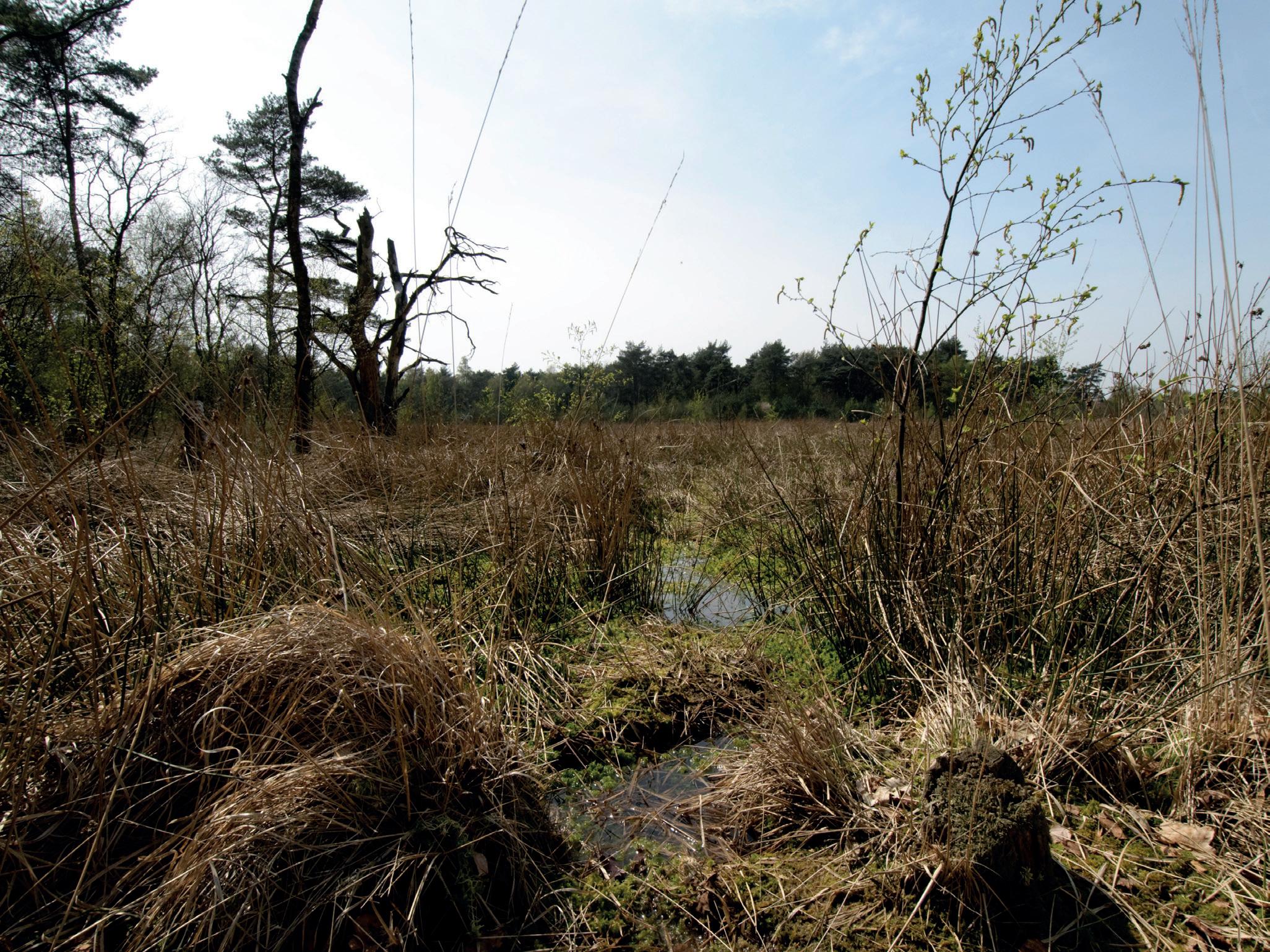
© Rene Koster
EXECUTIVE SUMMARY
WATER SCARCITY IS THE RESULT OF WATER MISMANAGEMENT
From crop failures to shrinking lakes, nature and people in Europe are increasingly suffering from a lack of water.
Climate change is exacerbating these issues, with more frequent droughts affecting water supplies, but the primary responsibility lies with the way we consume, regulate, and use water. We have been overusing water for years, and mismanaging it in a way which does not allow the water cycle to fully play its beneficial role. We dam and channel our rivers, destroy watersheds, drain our wetlands and fail our land use planning. In doing so, we are disrupting the water cycle and threatening the water we need to sustain our basic needs, our landscapes and our activities. Water scarcity is not a natural event, but the result of long-term and extensive water mismanagement. This report presents four case studies from across Europe which reveal different water mismanagement issues: illegal, excessive and/or uncontrolled water abstraction for agriculture (Spain; The Netherlands); illegal filling and operation of water reservoirs for agriculture (France); and illegal construction and irregular operation of hydropower plants without considering flows of water necessary for nature and people (Bulgaria). These case studies are only a snapshot of the more profound and widespread management issues across the continent.
To cope with changing water availability, water management strategies should prioritise water retention in the landscape so that it is taken up by the vegetation or the water bodies and recharges the groundwater. This will ensure that ecosystems are healthy, resilient and, as a result, are also able to keep supplying good quality water in sufficient quantity and in good quality (including during dry periods) for drinking and other human uses.
A STRONG EU WATER AND CLIMATE ADAPTATION AGENDA
Strong EU policies – with the Water Framework Directive as a cornerstone – are in place and provide a framework for a holistic water governance. However, these policies are not sufficiently implemented, and they are sometimes undermined by other EU policies such as the Common Agricultural Policy, while the EU lacks robust policies on adaptation to climate change. A change of paradigm needs to happen in order to preserve the water cycle, starting with managing the landscape to keep water for nature and for people. We need to rethink our water management practices to ensure water resilience and water conservation. The EU can lead the way by driving a strong water and climate adaptation agenda, making full use of all the legal tools available in the existing legislation.

GLOSSARY
Drought: A drought is a natural phenomenon characterised by persistent unusual dry weather conditions, usually deriving from a temporary, negative and a severe deviation from average precipitation levels over a significant time period and large region (a rainfall deficit also known as a meteorological drought). These episodes might lead to agricultural, hydrological and socioeconomic droughts, depending on their severity and duration. An agricultural drought refers to a situation with reduced levels of soil moisture in agricultural land as a result of a meteorological drought. If the severity of the drought causes reduced levels of natural water flows to surface water and groundwater, it is called a hydrological drought. A socioeconomic drought occurs when the hydro-meteorological conditions lead to a situation in which water supply cannot meet demand, with negative social, economic and environmental consequences. Long-term drought conditions (e.g. seasonal or year-round) cause aridity, whereas longer periods of drought (multi-annual) may contribute to the progress of desertification in certain areas.
Ecological Flow: Ecological Flow (or Environmental Flow or Eflow) describes the water regime (quantity, timing and quality) that is required to sustain the health of aquatic ecosystems and the provision of their ecosystem services for human wellbeing. As such, the concept goes far beyond the sole consideration of minimum flows to support aquatic life in dry periods.
Water abstraction: Water abstraction is the process of taking water from a natural water body or a man-made one (e.g. a reservoir), either temporarily or permanently.
Water consumption: The quantity of water that is not returned to groundwater or surface water because it is incorporated into products (e.g. food and beverages) or consumed by households (e.g. drinking water), plants, or livestock (evapotranspiration). It is calculated as the difference between total water use and supply to other sectors, and the returns of water to surface water and groundwater. Thus, it may include transpiration of water from plants and livestock, the losses due to evaporation during distribution and the apparent losses due to unauthorised abstractions and malfunctioning metering devices.
Water scarcity: Water scarcity is a man-made phenomenon that arises from an overuse of water resources. It is defined by a recurrent imbalance in which consumption is significantly higher than the natural availability. Water scarcity is a mid-term water stress condition (e.g. seasonal, annual or multi-annual), occurring when the water demand for human needs exceeds the sustainable supply capacity of both the natural and human allocation systems in river basins. Water scarcity can be measured as the ratio between renewable freshwater resources and water abstraction or water use. Water scarcity can be aggravated by water pollution (reducing the suitability for different water uses) and drought episodes that further reduce water availability.
Water stress: Water stress refers to the difficulty to meet the human and ecological demand for water. When severe and prolonged, water stress can lead to water scarcity scenarios. Compared with scarcity and shortage, water stress is a more inclusive and broader concept. As well as water scarcity, it also considers water quality, ecological flows and water accessibility.

BALANCING PEOPLE’S AND NATURE’S NEEDS FOR WATER
© Emiliano Arano
WATER IS LIFE
It is the most crucial element for the survival of all living organisms on earth. On a global scale, water serves as the primary disperser of energy, transporting and distributing solar energy across the planet. The oceans, for example, act as a heat sink, helping regulate global temperatures by absorbing and releasing heat. The water cycle, which involves the evaporation and precipitation of water, helps to distribute heat and moisture around the planet, which is essential for maintaining a stable climate. Functioning ecosystems are a crucial element in the water cycle. Ecosystems store, release and purify water and keep it in the landscape for use by plants, animals, and human societies and economies.
Water is also the foundation of the world’s ecosystems. Rivers, wetlands, lakes and oceans provide habitats for countless species of aquatic life, transport sediment, and contribute to the overall health of the planet. Freshwater ecosystems, such as wetlands, floodplains
or riparian forests, are among Europe’s and the world’s most productive ecosystems. They also play a crucial role in adapting to climate change by buffering floods and droughts. Water also plays a critical role in many social and economic activities, from tourism, navigation, energy production and irrigation to hygiene and cooking. Last but not least it is our source of life – as we all depend on drinking water. Allowing a sufficient and constant inflow of water in water bodies is of crucial importance for nature and for people, in particular to secure groundwater stocks, which allows us to cope with water stress or water scarcity.
WATER IS NOT AVAILABLE IN SUFFICIENT QUANTITY AND QUALITY ACROSS EUROPE
Water stress affects on average 20% of the European territory and 30% of the European population every year (figure 1). Droughts in Europe cause up to EUR 9
Water Exploitation
No data Sub river basin without data
Outside coverage
Figure 1: Seasonal water exploitation index plus (WEI+)1 in European sub river basins, 2015 (adapted from EEA, 2021). The darker the colouring, the higher the water exploitation index.
billion of economic damage annually and those costs could rise to EUR 25 billion per year at 1.5 °C of global warming, EUR 31 billion per year at 2°C of warming and EUR 45 billion at 3 °C warming2. This does not include additional unquantified damage to ecosystems and their services, including food supply. The average annual area of croplands affected by drought in Europe during 2000-2021 was already around 62,000km2 – twice the surface area of Belgium3. Southern Europe faces severe water stress problems which occur throughout the year in many river basins. In other parts of Europe, water stress is usually not a permanent issue as it mainly occurs occasionally and in specific hotspots4 – with a lower level of preparedness.
Water stress is not only impacting the availability of water in terms of quantity; it can also intensify water pollution problems in some river basins in Europe. In simple terms, pollutants are more concentrated when there is less water in a given water body, affecting not only physicochemical but also biological processes that are key for the functioning of aquatic ecosystems and aquifers. This was, for instance, observed in the Oder river, where the
drought and the resulting low water levels in August 2022 were seen as one of the contributing factors to the death of approximately 360 tonnes of fish caused by industrial wastewater discharges with a high salt content5. Water stress conditions can ultimately lead to water scarcity scenarios if managers cannot address it efficiently and timely.
WATER SCARCITY IS THE RESULT OF YEARS OF WATER MISMANAGEMENT
First, we use too much water in Europe. Although both abstraction and consumption have decreased across the continent since 20006, the pressure has increased locally, especially in the areas already suffering from the highest risks. For instance, in the already water-stressed southern Europe, the irrigable area increased over the period 2010-20177.
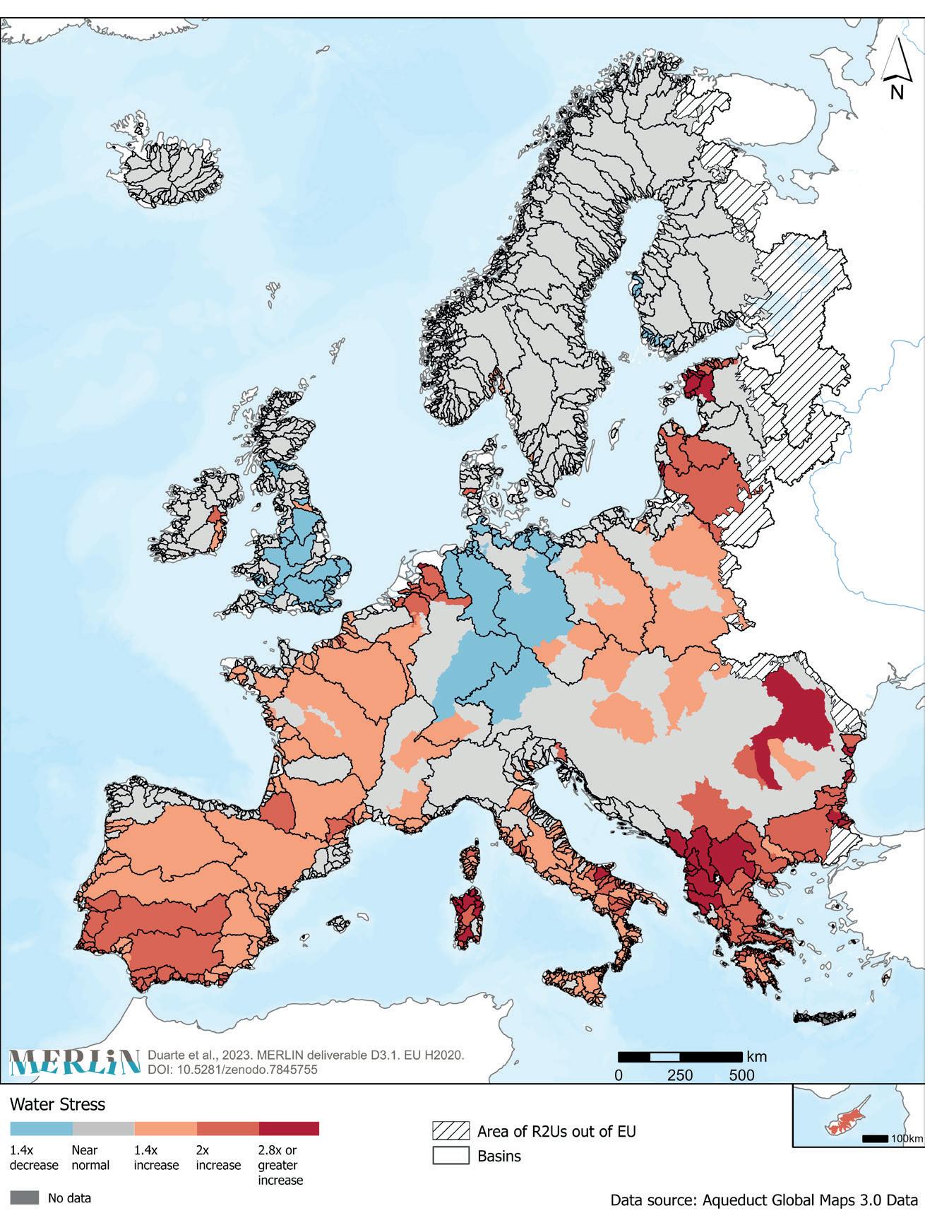
Figure 2: Projected change in water stress from 1950-2010 to 2040 under a business as usual scenario (MERLIN project, 2023).
THE AVERAGE ANNUAL AREA OF CROPLANDS AFFECTED BY DROUGHT IN EUROPE DURING 2000-2021 WAS ALREADY AROUND
62,000KM2
Second, Europe’s waters have been suffering for decades from poor management practices such as damming or drainage which have made freshwater ecosystems less capable to cope with drought, heat-waves, and floods, or to play their key function of sediment transport8. River channelisation, soil artificialisation, hedge grubbing and wetland drainage have been commonly carried out to get rid of water during winter and make room for intensive agriculture, resulting in a sharp decrease of water in the landscapes and in the aquifers. As a result, soil moisture and soil health also declined, which could backfire and cause lower agricultural yields today9. Some of the traditional engineering solutions, such as damming rivers to create water reservoirs, have also shown their limits. According to a recent study, 53% of the world’s largest natural lakes and artificial reservoirs have faced significant storage declines over the 1992–2020 period. In natural lakes, the main causes are climate warming, increasing evaporative demand, and human water consumption, while in reservoirs, sedimentation is the leading cause of storage losses10
The EU Water Framework Directive11 (WFD) adopted in 2000 provides a suitable framework for acting on the policy options to reverse water scarcity and drought. The WFD was meant to ensure the full integration of ecological and socio-economic perspectives in water quality and quantity management. Its key objective was to achieve, by 2015, “good status” for all surface water bodies (e.g. rivers, lakes, coastal waters) and groundwater bodies in the EU. The WFD allows for the 2015 deadline to be extended, provided extensions are limited to at most two further 6-year “implementation cycles”: 2016 to 2021 and 2022 to 2027 – the final deadline to achieve the WFD objectives.
However, 20 years after the adoption of the Directive, only 40% of surface waters are in good ecological status with large disparities among Member States12, and only 38% are in good chemical status13. In France, 51.5% of the water bodies are under hydromorphological pressures, many of them deepened and channelised, which often leads to less infiltration and aquifer recharge. 26% of EU groundwater bodies are not in good chemical status, and 11% of them in are not in good quantitative status.
The status of Europe’s freshwaters will not significantly improve by 2027, as was revealed by a thorough NGO assessment of draft versions of the 3rd cycle of the EU countries’ River Basin Management Plans (RBMP)14 –the main instrument to achieve the WFD’s objectives. The assessment documents a general failure of Member States to integrate water protection and the WFD’s environmental objectives with other policies, in particular energy, agriculture, and infrastructure policies. Twenty years after the adoption of the WFD, EU Member States continue to channel enormous amounts of public funds into environmentally harmful activities, which counteract and hinder the achievement of a good ecological, chemical and quantitative status for our waters, undermining the objectives of the European Green Deal too.
Third, there has been too much focus on emergency measures, not enough on prevention measures, such as the restoration of wetlands as a managed aquifer recharge, which can increase soil moisture, enhance the drought resilience of plains and therefore help safeguard agricultural production15. Instead, over 50% of Europe’s wetlands have been lost between 1700 and 202016.
WATER SCARCITY IS AGGRAVATED BY THE IMPACTS OF CLIMATE CHANGE
Last but not least, climate change is likely to change the amount of water available regionally, exacerbating both problems concerning water quality (less water in a river or lake means higher concentrations of substances) and water quantity. The expected temperature rise increases potential and actual evapotranspiration, causes more water consumption overall, leads to more frequent extreme droughts, intensifies heavy precipitation, attenuates snowpack build-up and triggers early snow melting. These effects are projected to cause seasonal reductions in water availability in most parts of Europe, except in northeastern areas of Scandinavia, including decreasing river discharges of up to 40% (under a 3°C temperature rise scenario) and leading to increasing water stress. Changes in aquifer recharge follow roughly the same pattern17
OF EU GROUNDWATER BODIES CARRY POLLUTED WATER, AND THE WATER LEVELS ARE TOO
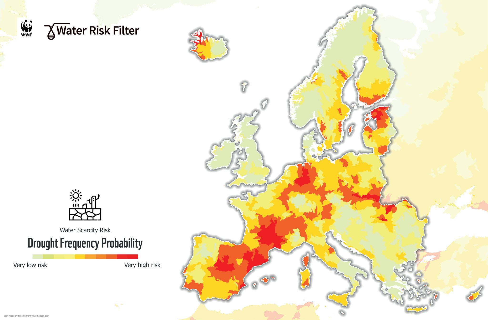
Figure 3: Drought frequency probability considering the last 10 years (August 2011 – July 2021) as reference period18 (WWF, Water Risk Filter).
With climate change, lower rainfall, higher temperatures and dry periods will become longer, more frequent, and more intense in Europe Projections from the Intergovernmental Panel on Climate Change (IPCC) indicate that in Europe, soil moisture will decrease and long term droughts will become more common in the coming decades. In the EU, drought events are becoming longer, more frequent, and intensified by the continuous warming. Places already experiencing the greatest scarcity challenges, like the Mediterranean region, are likely to experience even greater strain in the years to come19, including a marked increase in the number of days with high fire danger20 .
NATURE’S WATER NEEDS HAVE BEEN FORGOTTEN AND WE ARE PAYING THE PRICE FOR IT
Rainfall alone cannot fully “recharge” hydrological systems that are overexploited, at the pace needed by nature and people, so activities that use a lot of water need to be carefully assessed to better adapt to the impacts of climate change. For example, some areas of Spain have opted for a model of water use that prioritises high consumption of water and soil resources21, like the expansion of industrially-produced, thirsty irrigated crops, despite the fact that they are exposed to extended periods of drought due to their geographical location. Nevertheless, consumers still received water with hardly any restrictions – it was the environment that paid the price.
WATER PRICING: A POWERFUL BUT UNDERUSED MANAGEMENT TOOL FOR AGRICULTURE
In a 2021 report, the European Court of Auditors found that agricultural policies at both EU and Member State level were not consistently aligned with EU water policy. In particular, the Court criticised systems for authorising water abstraction, and water pricing mechanisms that contain many exemptions for agricultural water use. The Water Framework Directive obliges Member States to adopt water pricing policies that incentivise efficient water use, and ensure that the financial costs of water provision, as well as the environmental and resource costs of water services, are adequately recovered from the various users including farmers. However, the Court of Auditors stated that for the majority of the national and regional authorities of the Member States covered in their audit, cost recovery for water services in agriculture was incomplete and environmental and resource costs were not (yet) reflected in water pricing.
Inadequate water pricing is one of the factors contributing to the overuse of water. However as it would require a detailed economic analysis, it is beyond the scope of this study22.
Poor water management has led to water scarcity in several ways. In this report, we focus on the following ones:
Over-allocation of water resources based on over-optimistic scenarios regarding rainfall, run-off and groundwater recharge. When allocating water to different uses, there is a significant risk of allocating water that may not be available during the year ahead due to a possible disparity between demand and supply, especially if the rainfall is less than expected. This is one of the key consequences of climate change on water: as the uncertainty rises, water managers are facing more challenging decisions on how to allocate and safeguard water resources. This also affects the amount of water that is left available for the environment, as proper ecological flow regimes (with all their components), as well as water needs for wetlands
and other freshwater habitats, are not defined for the vast majority of river basins in Europe.
Excessive, unknown or sometimes illegal abstraction of surface and groundwater. 10% of the length of European rivers are affected by significant water abstraction pressures – up to 25% in France and 45% in Spain23, and 17% of the area of groundwater bodies is affected by over-abstraction24. These numbers do not accurately represent the real problem, as overabstraction is most pronounced in the regions that are already suffering most from water stress conditions. In addition, the RBMPs usually do not account for illegal or unregistered water abstraction, which is considerable in some Member States, and they sometimes overestimate the rate at which groundwater is being recharged.
The over-abstraction of groundwater resources can also impact rivers. When shallow alluvial aquifers lie beneath and adjacent to flowing rivers, pumping groundwater from these shallow aquifers can reduce the flow of water in a river in two ways. First, it can intercept groundwater that would have otherwise discharged (drained) into the river (the so-called “baseflow”), and second, it can suck water directly out of the river and into the pumping well
when the level of the shallow groundwater is depleted and drawn down below the level of the river (figure 4, second drawing)25 . Four river basins in the EU are in the 50 global river basins with the greatest volumes of groundwater pumping: Danube, Seine, Guadalquivir and Guadiana. In the Danube and Seine, more than half of the pumped volume comes from river depletion26.
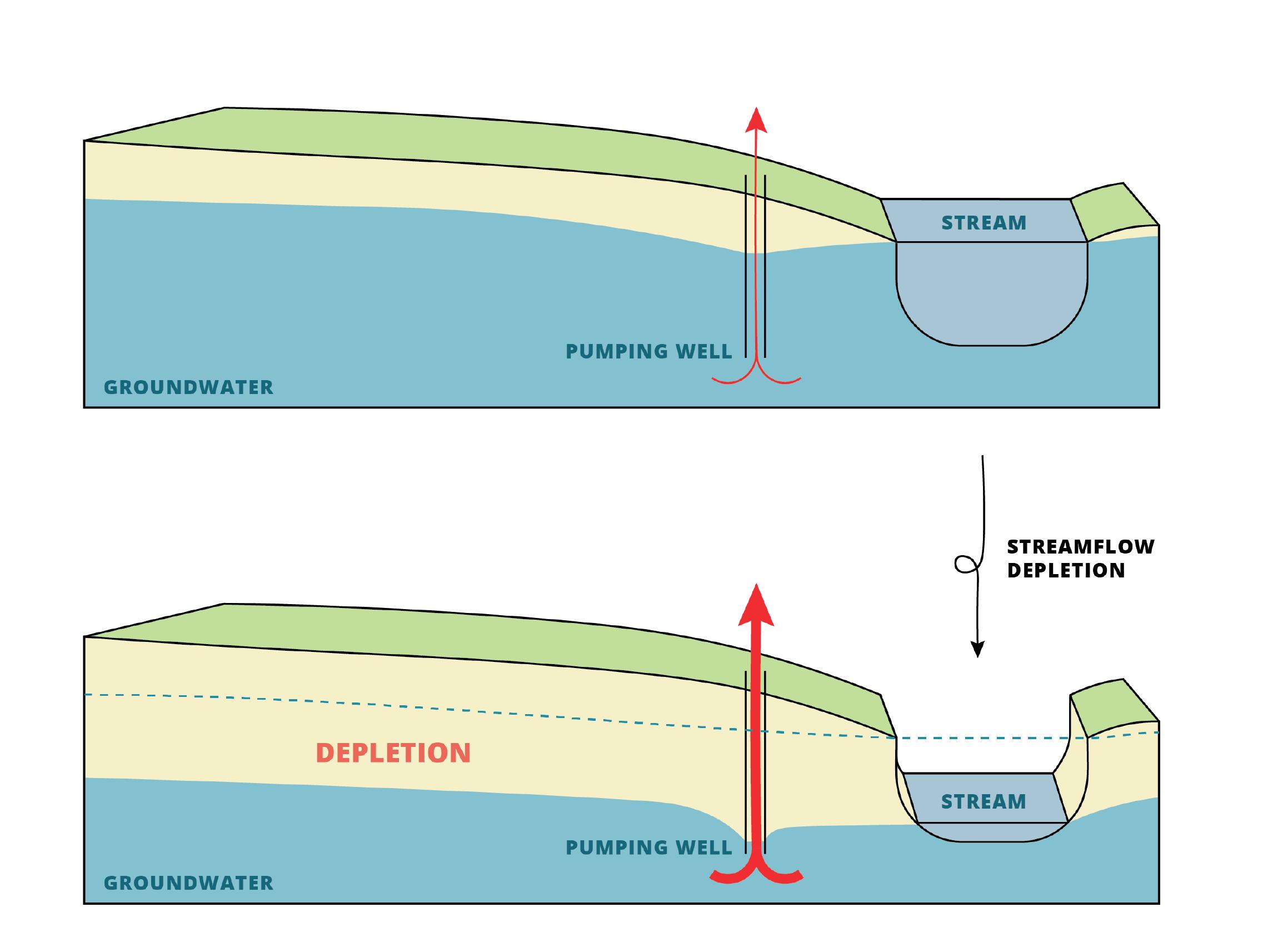
Figure 4: How pumping wells reduce the flow of rivers (WWF, 2022).
Construction of impoundments for water storage, many of which are not subjected to WFD scrutiny which is legally binding for new projects (Art. 4(7)). Virtually all of Europe’s rivers have had their flows regulated by dams or reservoirs, mainly for hydropower, drinking water, or irrigation for agriculture.
WFD provisions acknowledge the critical role of the “hydrological regime” (i.e. water quantity and dynamics) in supporting the quality of aquatic ecosystems and the achievement of environmental objectives27. Over the past three decades, the scientific literature has extensively discussed the correlation between the hydrological regime, physical habitats, biotic composition and the health of aquatic ecosystems. This link has gained considerable attention. There is ample evidence documenting the crucial role of the hydrological regime in determining physical habitats, which is summarised under the concept of “ecological flow regimes”. Ecological flows can be described as the “amount of water required for the aquatic ecosystem to continue to thrive and provide the [ecosystem] services we rely upon28 ,” and goes far beyond the sole consideration of minimum flows to support aquatic life in dry periods.
Ecological flows are a crucial element for protecting aquatic ecosystems, achieving WFD objectives and safeguarding
human benefits derived from healthy ecosystems, and one of the indicators of a functional and resilient hydrological regime. However, water management authorities often tend to prioritise water abstraction, or construction of infrastructures such as dams or impoundments, over the proper implementation of ecological flows. Such infrastructures increase river incision; they disconnect the river from the floodplain, improperly divert flows, and impede the natural retention process through the replenishment of aquifers.
WATER NEEDS TO STAY IN THE LANDSCAPE
Despite the fact that EU water policy – the cornerstone of which is the WFD – recognises the critical role healthy freshwater ecosystems play in tackling the effects of droughts and mitigating the impact of climate change, EU Member States have so far failed to make the law work in practice. They are falling desperately short of their commitments and not implementing the required measures to ensure that these ecosystems are healthy, resilient and, as a result, able to keep supplying enough good quality water during dry periods.
Legend:
1. Raindrops intercepted by rough vegetation
2. Water that reaches the ground is able to infiltrate
3. Water stored in the soil stays there as long as possible, before it reinfiltrates
4. Water that comes to the surface in valley floors is stored in vegetation
5. Once in the riverbed, water flows as slow as possible thanks to meanders
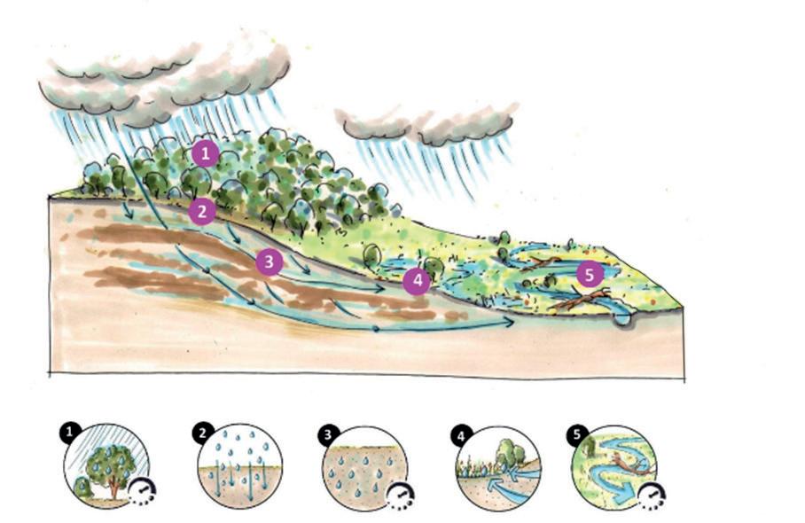
5: Principles of delaying water, (adjusted from Stroming Netherlands, 2023).
Figure
Natural, intact ecosystems, including freshwater ones and the ecological flows supporting them are crucial to support the water cycle and many human activities. It is therefore vital to reserve water for nature and keep it in the landscape to mitigate the effects of water scarcity and droughts.
Water retention in the landscape refers to the ability of a landscape or an area to capture, store and hold water. This occurs through natural processes and ecosystem functions. Certain management and conservation practices can minimise water runoff and maximise water infiltration and storage. Depending on the type of landscape and
ecosystem this can include preserving existing vegetation, reforestation and afforestation of riparian areas, wetland conservation and restoration, riparian zone management, soil conservation and agroecological farming practices. By reducing run-off, enabling groundwater recharge and increasing soil moisture, these nature-based solutions (also including Natural Water Retention Measures – NWRM) are a crucial contribution to mitigating water scarcity and drought and also bring various other societal benefits29
ADDRESSING WATER SCARCITY THROUGH NATURE-BASED SOLUTIONS
Nature-based solutions have the potential to provide multiple wins related to water scarcity with benefits for nature and people: they can increase soil moisture (and ultimately soil quality for various uses), they can enable groundwater recharge, they can improve river discharge and lake levels, and they can buffer temperature changes. Such nature-based solutions may include protecting and restoring wetlands and rivers to ensure they are healthy and functioning, with adequate flow regimes, as well as restorative agricultural techniques such as agroecology to improve the quality of the soils. These are key strategies in the face of water scarcity and droughts. They can help store water, increase infiltration to the soil and aquifers and buffer temperature changes, mitigating associated water stress. The same measures that help retain water in the landscape to mitigate droughts can mitigate floods.
WATER SCARCITY IS NOT A NATURAL EVENT, BUT THE RESULT OF LONG-TERM AND EXTENSIVE WATER MISMANAGEMENT.
WATER SCARCITY IN EU POLICIES
Water scarcity is addressed in numerous ways in EU legislation, not just limited to water-related legislation, as it links to land and water use by different activities and sectors.
THE WATER FRAMEWORK DIRECTIVE
The Water Framework Directive aims to maintain and improve the quality of aquatic ecosystems in the EU. The WFD requires surface waters to be classified through the assessment of ecological status or ecological potential and surface water chemical status. WFD Annex V explicitly defines the quality elements that must be used for the assessment of ecological status/potential. The lists of quality elements for each surface water category are subdivided into 3 groups of “elements”: (1) biological elements; (2) hydromorphological elements supporting the biological elements; and (3) chemical and physicalchemical elements supporting the biological elements. The hydrological regime is part of the hydromorphological quality elements.
The EU Guidance Document No 31, “Ecological flows in the implementation of the Water Framework Directive”, contains a working definition of ecological flow regimes, considered as “a hydrological regime consistent with the achievement of the environmental objectives of the WFD in natural surface water bodies as mentioned in Article 4(1)30” .
The definition of ecological flows hence encompasses all environmental objectives in article 4(1), which are:
Non-deterioration of the existing status: As a general principle, ensuring non-deterioration in the status of water bodies means that any new significant alterations in the hydrological regime should be actively prevented.
Achievement of good ecological status (GES) in a natural surface water body: The WFD does not specify the flow regime required to achieve GES but requires the flow regime to provide conditions “consistent with the achievement of the values specified for the biological quality elements”. Namely, the hydrological regime can deviate from the nearly natural range but must not impact biological quality elements beyond the values specified for GES. However, in the second RBMPs ecological flows had been reported to be derived and implemented for all relevant water bodies in only very few Member States. The latest implementation report suggests that no progress has been made so far31
Compliance with standards and objectives for protected areas, including the ones designated for the protection of habitats and species where the maintenance or improvement of the status of water is an important factor for their protection. This includes relevant Natura 2000 sites designated under the Birds and Habitats Directives. This means that, in practice, water needs for habitats and species should be defined in coordination with the RBMPs and the Plans for Natura 2000 sites.
For water bodies that are designated as “heavily modified water bodies” and/or qualify for an exemption, the flow regime requirements have to be derived by taking into account the technical feasibility and socio-economic impacts on water use that would be impacted by the implementation of ecological flows.
Art. 4(1) objectives are legally binding for all EU Member States. The WFD, however, accounts for exemptions to the environmental objectives.
EXEMPTIONS TO THE WFD’S ENVIRONMENTAL OBJECTIVES
Article 4.4 allows for the extension of deadlines to reach environmental objectives because of disproportionate costs, technical (in)feasibility or natural conditions.
Article 4.5 allows for less stringent objectives when a water body is so affected by human activity or by its natural condition that the achievement of objectives is infeasible or the costs disproportionate.
Article 4.6 allows for “temporary deteriorations” in the case of natural circumstances or “force majeure” (severe floods, prolonged droughts, accidents etc.).
Article 4.7 allows for new modifications affecting water bodies.
Exemptions can cause deviations from environmental objectives, and hence affect the implementation or maintenance of ecological flows. Therefore, exemptions have to be thoroughly justified and should be regarded as a last resort. Technical guidance and good practices for water managers and experts are provided by the CIS Guidance Documents No. 20 and No. 3632
The WFD also provides a suitable framework to address water scarcity and drought by underscoring the relation between water quantity, water quality and ecological status. Of special importance for addressing water scarcity are the WFD’s aims to: ensure a good quantitative status of groundwater bodies; achieve good ecological status of surface water bodies (including in terms of supporting environmental river ecological flow regimes requirements and hydromorphology, which support aquifer recharge); and identify significant pressures from abstraction and flow variations. (Art. 5).
Furthermore, the WFD in Art. 11(3)(e) requires Member States to set up “controls over the abstraction of fresh surface water and groundwater, and impoundment of fresh surface water, including a register or registers of water abstractions and a requirement of prior authorisation for abstraction and impoundment. These controls shall be periodically reviewed and, where necessary, updated. Member States can exempt from these controls, abstractions or impoundments which have no significant impact on water status.” However, the last implementation report from the European Commission
shows that although almost all Member States have a permitting regime or register to control abstractions of groundwater and surface water, about half of all Member States reported that small abstractions are exempted from controls33 .
The WFD also refers to the objective of “rational utilisation of natural resources” deriving from the EU treaties (WFD preamble point 11, which refers to Art. 174 Treaty establishing the European Community).
The link between surface and groundwater is essential for a proper analysis of hydrological conditions. The flow regime in aquatic ecosystems is in many cases heavily dependent on natural groundwater outflow which is a stable flow component. Natural groundwater outflow is especially important in maintaining flows during low-flow and drought situations (dry weather flow) and chemically different from surface derived flows. Thus, groundwater outflow is essential for meeting specific biological requirements34
This input is critical for many groundwater-dependent terrestrial ecosystems, such as temporary rivers and lakes that are especially prevalent in southern EU Member States. It also plays a major role for biodiversity protection and many Natura 2000 sites whose habitats and species depend on groundwater outflow, both in terms of quantity (e.g. providing a long term stable refuge on floodplains that is essential for survival during extreme low flows) and quality (e.g. stable temperature, oxygenated habitats in river sediments, and essential chemical habitat aspects for adapted species such as in alkaline rivers).
THE AD-HOC TASK GROUP ON WATER SCARCITY AND DROUGHTS
An Ad-hoc Task Group on water scarcity and droughts (ATG WSD), co-chaired by Spain, Portugal, the European Commission and the European Environmental Agency, was created in 2022, as part of the Common Implementation Strategy of the Water Framework Directive. Among its tasks are the update of the CIS Guidance Document No. 24 “River Basin Management in a Changing Climate”, and the preparation of a report on water scarcity and drought management in terms of river basin management planning and risk reduction. This report will identify implementation challenges, good practice for water balances and ecological flows, and provide some guidance for the drafting of Drought Risk Management Plans (DRMPs), which are complementary to River Basin Management Plans. The challenge is to provide adequate guidance to Member States, so that it is acknowledged that water scarcity and drought are distinct phenomenon requiring distinct measures, and that DRMPs do not become an instrument to increase water abstraction during drought episodes without all the environmental controls and provisions that must be complied if this were to happen within a RBMP cycle.
The WFD, as well as the Nature Directives, sets binding objectives on the protection and restoration of waterdependent ecosystems. These objectives can only be reached if supporting flow regimes are guaranteed and human activities that increase water scarcity conditions are limited and well-managed. The establishment and maintenance of ecological flows as well as a good water quantity management are therefore essential elements in meeting those legally binding objectives. Therefore,
consideration of ecological flows and the regulation of abstractions and impoundments should be included in national legal frameworks, including binding ones as appropriate, referring clearly to the different components of the natural flow regime (and not only to minimum flow) and the necessity to link their definition to biological requirements according to the objectives of WFD and the Nature Directives.
OTHER EU WATER LAWS ON ADDRESSING WATER QUANTITY MANAGEMENT
The Regulation on minimum requirements for water reuse for agricultural irrigation establishes new rules to stimulate and facilitate water reuse in the EU.
The Recast of the EU Drinking Water Directive addresses leakage in the water supply networks, and risk assessment and management of the catchment areas for drinking water abstraction. The Floods Directive aims to reduce the risk of flood damage in the EU.
WATER SCARCITY IN THE NATURE DIRECTIVES
The Birds and Habitats Directives, known together as the “Nature Directives,” aim to conserve important habitats and species. Although there is no explicit reference to ecological flows in these directives, flow regime is a critical element controlling the conservation status of the related protected habitats and species for most aquatic ecosystems. Sites which are designated under the Birds and Habitats Directives and where the maintenance or improvement of the water status is an important factor in their protection are “protected areas” under the WFD (Art. 6 and 8, Annex IV). This is to some extent reflected in the EU guidance on hydropower in Natura 2000 sites35
The maintenance of the conservation status of waterdependent habitats and species protected under the Birds and Habitats Directives may require flow conditions which are different or go beyond those required for the achievement of GES or the maintenance of high ecological status.
Many of the habitats and species protected under the Habitats and Birds Directives depend on the adequate availability of water and on good ecological and chemical status of surface waters. For example, 39 floodplain habitats and 14 bog, mire and fen freshwater habitats are listed in Annex I of the Habitats Directive. In many cases, the availability of surface or groundwater is critical to achieving their good conservation status. Thus, a clear link exists between the objectives of the WFD and the Nature Directives.
OTHER EU ENVIRONMENTAL AND CLIMATE LAWS ON WATER QUANTITY MANAGEMENT
The EU Biodiversity Strategy 2030 states that “Member State authorities should review water abstraction and impoundment permits to implement ecological/GEP36 flows in order to achieve good status or potential”, and the European Commission is required to provide technical support to Member States on their actions by 2023.
The EU strategy on adaptation to climate change revised in 2021 includes a specific section on water and includes relevant commitments, in particular to “improve coordination of thematic plans and other mechanisms such as water resource allocation and water permits”, and “help guarantee a stable and secure supply of drinking water by encouraging the incorporation of the risks of climate change in risk analyses of water management”.
The European Climate Law (Article 5(4)) requires Member States to adopt and implement national adaptation strategies and plans, and to promote naturebased solutions and ecosystem-based adaptation.
WATER SCARCITY IN THE COMMON AGRICULTURAL POLICY
With agriculture being the biggest user of water in Europe, the Common Agricultural Policy has an important role to play in coping with water scarcity. However, too many structural issues are in the way. Firstly, too much coupled CAP support goes to livestock production which is very water-intensive. Over 63% of all EU arable land is dedicated to feeding livestock37, while globally the average water footprint per calorie of beef is 20 times higher than that of grain38. Secondly, rural development funds and market measures do not significantly promote sustainable water use, as part of the actions for the agricultural sector to adapt to climate change challenges and impacts39. The CAP framework for 2023-2027 includes several safeguards related to investments in irrigation, such as a minimum water saving requirement for improvements to increasing irrigation, and some limitations to investment resulting in a net increase of the irrigated area40, but it remains to be seen how these provisions are implemented. The CAP framework for 2023-2027 also includes conditionality requirements on water and soil protection which are also relevant to foster water retention (Good Agricultural and Environmental Conditions 1-3 and 5-7), but they are not strong enough and are implemented too weakly by Member States41
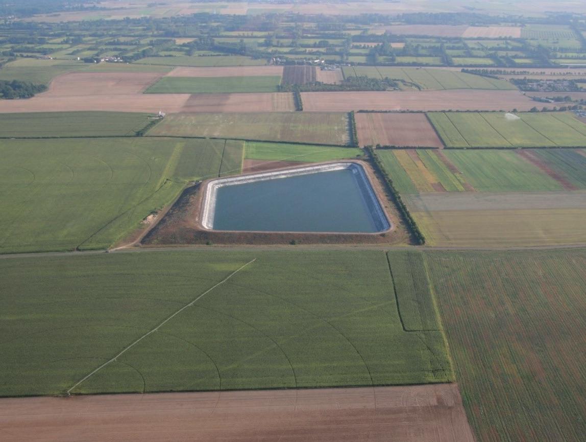
A large reservoir in the Mignon catchment area, western France.
© Nature Environnement 17 (NE17)
CASE STUDIES
This section includes a selection of case studies which illustrate how the mismanagement of water, in particular abstraction and impoundments, and in most cases directly breaching EU and/or national laws, can lead to situations of water scarcity. This list of cases is by no means exhaustive. Further general water governance issues, likely to aggravate water scarcity, were also identified in countries such as Germany, Hungary and Italy while conducting this research but are not documented here.
DOÑANA, SPAIN
Mismanagement of water bodies is pushing Doñana to its limits
SUMMARY
Mismanagement of water resources in Doñana, a World Heritage Site known for its water-dependent biodiversity, has been notorious for decades. Massive overabstractions and illegal abstractions from the aquifer used for large-scale irrigation of water-intensive crops have put the ecosystem on the verge of disappearing. Despite a 2021 ruling by the EU Court of Justice that found Spain at fault due to “excessive extractions of groundwater” in Doñana, there is still no clear turning point in sight that would save Doñana from ecological collapse.
SEVILLA
Doñana Natura 2000 site
Doñana UNESCO national park
WHAT’S HAPPENING?
Situated in south-western Andalusia, Doñana is one of the most important hotspots for biodiversity in the world as it is key to the migration routes for many species travelling from Africa to Europe. The protected area, including Doñana National Park (covering 54,251 ha) and Doñana Natural Park (covering another 68,236 ha) is world renowned. The area is one of the most studied biosphere reserves, as it has an array of habitats and species that are key for nature conservation. As a Natura 2000 site (reference: ES0000024), Doñana is also protected under European law. Water plays a key role in the Doñana ecosystem, encompassing a complex system of surface and groundwater bodies feeding vast extensions of marshlands from the north towards the southern and eastern areas of the wetland.
Since the 1970s, irrigated agriculture has been expanded with strong support from the different governments. Today most of the areas around the borders of the protected areas are occupied by crops. Strawberriers and other berries dominate the north-western area; fruit trees and other water intensive crops are found in the northern area and rice-fields in the eastern and south-eastern limits. All of these crops demand a very significant amount of water, so the inlets of surface waters that enter Doñana marshlands have been severely reduced. In addition, massive groundwater abstractions have led to the overexploitation of the aquifer on which the Doñana ecosystem also depends. This overexploitation of water resources, in combination with increasing diffuse pollution problems related to agricultural use and inadequate wastewater treatment in some of the municipalities, have also impacted the water quality of both surface and groundwater bodies, posing an additional pressure on Doñana.
The expansion of industrial agriculture has been supported for many years by the different administrations. In 2020, the Guadalquivir River Basin Authority (RBA) finally declared three of the five groundwater bodies (in which the Guadalquivir RBA decided to divide the aquifer that feeds Doñana) as being at risk of not achieving good quantitative status: the most extreme measure in Spanish water legislation and the WFD regarding an aquifer in poor condition42. Moreover, illegal water abstractions are still a severe problem in the area with an estimation of more than 1,000 illegal wells and over 3,000 hectares of illegal crops43 .
All the pressures and threats affecting the quantitative and qualitative status of Doñana’s water are still present today. Only very recently, and especially after the ruling of the European Court of Justice from 202144 on the “excessive extractions of groundwater” which infringe the EU Water Framework Directive and the Habitats Directive, have the authorities begun to take action to reduce the pressures on Doñana and protect its waters. However, the results are still to materialise.
The solutions proposed to address these pressures have been diverse and include efforts to close illegal abstractions
(around 500 from official figures)45 as well as limit the amount of water for some crops (such as the rice fields on the shores of the Guadalquivir). Furthermore, the regrouping of groundwater abstractions in irrigators’ communities (CUAS46) has begun as an obligatory result of being declared at risk of not achieving good quantitative status. Also, it is mandatory to define the feasible rate of abstraction for the aquifer, as part of a specific Action Plan that the Guadalquivir RBA has to develop in order to ensure the achievement of the good status of the groundwater bodies affected. Other actions include restoring some of the streams (recently, a bog action aims to buy private land to recover the lost connection of the Guadiamar river with the marshlands in the north) and completing an array of detailed studies to know how the water systems of Doñana work. To date, not all the measures proposed have been implemented completely, and the ones deployed have not been fully effective in recovering Doñana.
WHICH RULES ARE BEING BREACHED?
In April 2020, the European Commission filed a formal complaint after years of WWF Spain’s work denouncing the abusive and unsustainable extraction of water in the Doñana area for the intensive cultivation of berries. In 2021, the Court of Justice of the EU ruled Spain at fault for “excessive extractions of groundwater” in Doñana which infringe the EU Water Framework Directive and the Habitats Directive.
In December 2022, the regional government made a proposal for a law to legalise more farming hectares around the north-west part of Doñana. After months of protesting from stakeholders including Civil Society Organisations (CSOs) and scientific institutions, the proposal was declined just before the regional election period. Again, in January 2023, the regional government made a similar legislative proposal to legalise illegal farming hectares and pushed the national government for more water resources to come from the neighbouring river basin, the TintoOdiel-Piedras basin. If adopted, the law will retrospectively legalise farms which were built without any legal land or water permits47, sending a very dangerous message regarding the lack of rule of law and a potential subsequent “pull effect” for new water users as has been seen in other areas in Spain. This would also increase the irrigated land, despite the 2021 ruling of the Court of Justice of the EU. In March 2023, the EU Commission raised its concerns about the law proposal and announced it would take follow-up action in case of its adoption48
HOW HAS THE AREA CHANGED?
Surface water used to flow from the north via the Guadiamar river, and from the west from the El Partido and La Cigueña streams, reaching the “marismas” to form a vast extension of marshlands in the core area of Doñana.
In the east and south-east, there used to be a connection with the Guadalquivir river via the “Brazo de la Torre” that fed the marshlands with a flow of a mix of fresh or brackish water depending on the level of the sea tide in the estuary. Also, in the southern mouth of the marshlands, the tidal Guadalquivir Estuary inlet entered, flushing brackish water into the wetland, providing a gradient of habitats inside the lagoons.
The south-west and southern limit (sand dunes) are dependent directly on a surface aquifer to feed the small lagoons and habitats providing one of the most biodiverse areas of Doñana. This surface aquifer is connected in depth with the bigger aquifer, Almonte-Marisma. This vast aquifer covers most of the area of Doñana. It is mainly recharged from surface runoff of streams in the northern area, including the Guadiamar River mouth near the border of the protected area. This upper-north part of Doñana is key for its survival as it is a contact and exchange area between surface and groundwaters. This very big aquifer is currently divided into five groundwater bodies according to the WFD nomenclature by the Guadalquivir River Basin Authority, although it is the same aquifer in hydrogeological terms. The justification for the administrative division of the aquifer is said to support a better management of abstractions and water levels.
KEY TAKEAWAYS
One of the most emblematic biosphere reserves in Europe is also one of the most emblematic cases of severe mismanagement, despite warnings since the 1980s. The lack of sufficient and effective control and monitoring of water abstractions limits the capacity of water authorities to set water balances effectively. Thus, it is hindering
the management of the water bodies in its aims to stop deterioration and ensure the achievement of good status of both groundwater bodies and surface water bodies.
The most recent push to set rules and limits on water abstraction (under the still pending Action Plan resulting as an obligation from Spanish water law due to the declaration of 3 out of 5 of the groundwater bodies at risk of not achieving good status) are yet to prove their ability to ensure the water needs of Doñana’s different habitats and species are met. These limits must include a proper ecological flow regime of the surface water bodies that feed Doñana.
There has been a lack of coordination and coherence of land-use policies (e.g. agricultural and environmental management) and water policies (e.g. expansion of irrigation and water abstractions above sustainable limits) in the area for decades. The overexploitation of the aquifer and inaction of the authorities has pushed Doñana to the verge of collapse and worsened the impacts of climate change in terms of water quality and quantity.
While most of the evidence is there, sufficient action has still not been taken. Different policies and authorities must work together to comply with the binding objectives of EU legislation (mainly the Habitats Directive and WFD). It becomes clear that lack of rainfall is no longer suitable as an “excuse” during water scarcity scenarios, exacerbated by more intense and frequent drought periods.
For the last 10 years, rainfall has been lower than the mean values registered in the area, mean temperatures have risen and wind regimes have shifted, resulting in a higher evapotranspiration rate. The combination of fewer water resources available due to both climate change and overexploitation has led us to a critical situation for the whole area. Doñana is on the verge of disappearing.
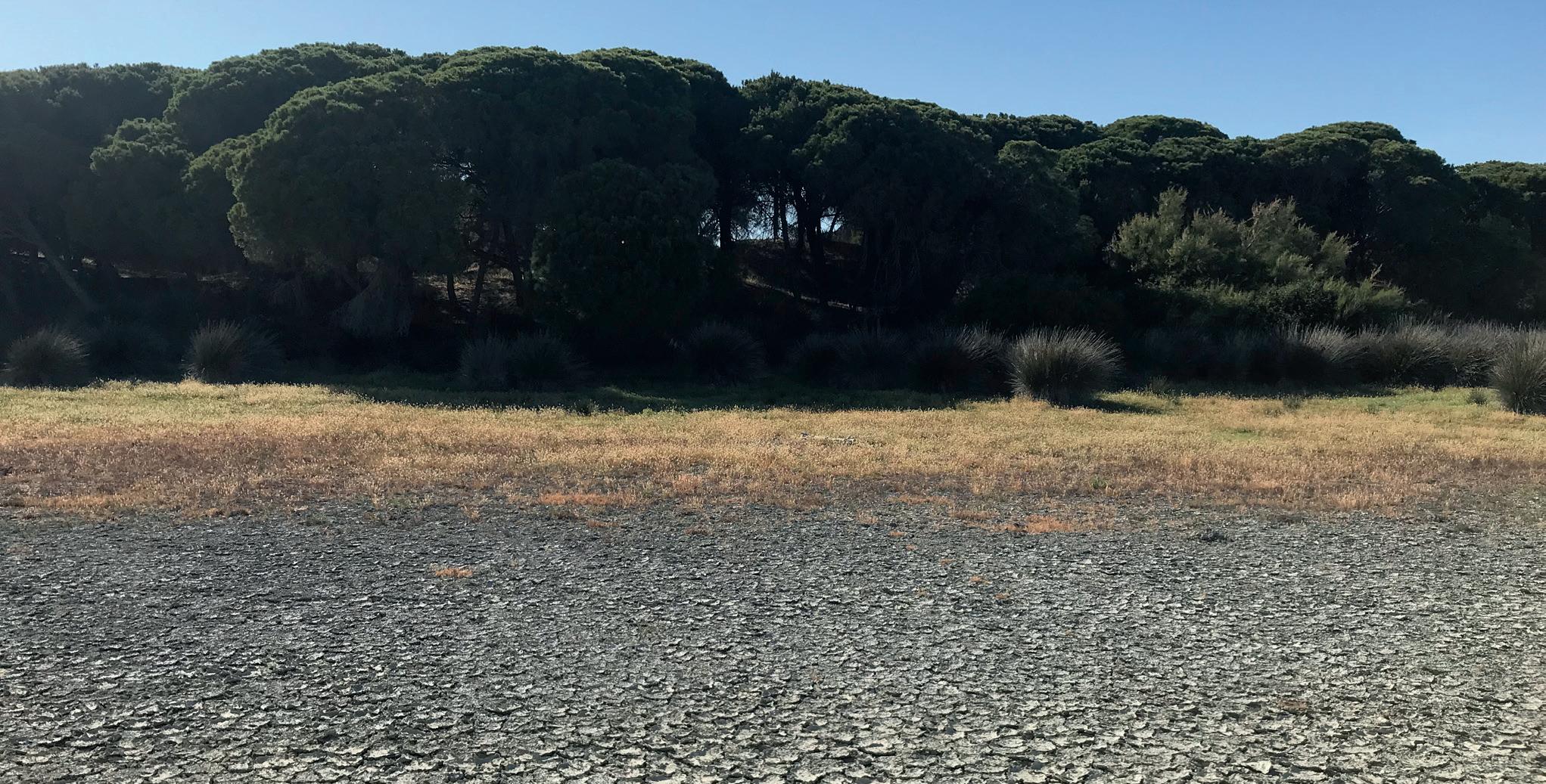
Drought on drained wetland in Doñana Natura 2000 site, April 2023.
© Claire Baffert, WWF EPO
MIGNON CATCHMENT, FRANCE
Illegally operated ‘mega reservoirs’ for large-scale irrigation put water sustainability at risk
SUMMARY
After 15 years, a legal dispute between a water-user association of irrigation farmers and a local environmental NGO in western France was settled in February 2023. The court found that five water tanks with a total capacity of 1.6 million cubic metres in the Mignon catchment were operated illegally due to an insufficient environmental impact assessment and non-compliance with the water management plan. The case illustrates a clear example of mismanagement of the increasingly scarce freshwater resources in western France, where a series of controversial “mega reservoirs” are being planned and constructed, many of them challenged in court.
Sévre Niortaise
LA ROCHELLE
Water reservoir
Natura 2000 site Marais poitevin
LeMignon
WHAT’S HAPPENING?
In 2006, the water-user association Association Syndicale Autorisée d’Irrigation (ASAI) des Roches requested permission to build and operate five water reservoirs in the municipalities of La Laigne, Cramchaban and Grèvesur-Mignon for irrigation. The five water tanks have a total storage capacity of 1.6 million cubic metres - the equivalent to 640 two meter-deep olympic swimming pools. Authorisation for the construction of the reservoirs was given in 2008 by the local authorities (Prefecture) of Charente-Maritime, but this was cancelled in December 2009 by the Poitiers Administrative Court upon a complaint by the local NGO Nature Environnement 17 The main reason for the cancellation was that the impact assessment was found to be insufficient. This decision was confirmed on appeal in November 2010 by the Bordeaux Administrative Court of Appeal.
Yet, the local authorities in Charente-Maritime invited the ASAI des Roches to reformulate their request for authorisation and authorised them to undertake protective measures for the reservoirs such as installing geomembranes and stabilising them by partially filling the reservoirs in the meantime. Despite the ongoing legal process and a formal notice by local authorities to stop any water abstraction for irrigation, the ASAI des Roches filled the reservoirs fully and used the water to irrigate cereal crops between 2011 and 2014.
The cost of the construction of the reservoirs is estimated at 6 million Euros, of which 70% comes from public sources, while twelve farmers benefit from the water reservoirs.
In 2014, the ASAI des Roches requested the authorisation to fill and operate these same reservoirs again; however, the total volume was reduced to 1,565 million cubic metres. This request was granted by local authorities in April 2015. The NGO Nature Environnement 17 challenged the authorisation before the Administrative Court of Poitiers, which cancelled the authorisation in June 2018, and again on appeal before the Bordeaux Administrative Court of Appeal in May 2022. During the appeal procedure, the ASAI des Roches had provided another impact assessment which was considered unsatisfactory. The scope of the study as a whole was too limited, particularly with regard to the appropriate assessment required under the Habitats Directive, including the reservoir’s impact on the Marais poitevin Natura 2000 site (reference FR5400446). The court noted that “the study gave no indication of the level of the water table prior to the first withdrawals, and the association referred to studies that were neither accessible to the public nor attached to the additional impact study.” Despite this unfavourable appeal ruling, the ASAI des Roches decided to appeal to the Council of State again. On February 3, 2023, the High Administrative Court did not admit the appeal by the ASAI des Roches
The presence of the Eurasian stone-curlew (on the IUCN red list of species, least concerned) was established in 2009 on the site (before the reservoir was built) and
compensatory measures were then added to the second authorisation request, but the impacts of the construction and operation of the reservoir on this species have not been studied. Although there might also be indirect impacts on aquatic fauna from the lowering of the water table and drying up of the rivers, these indirect impacts were never studied (no fish inventories were conducted).
WHICH RULES ARE BEING BREACHED?
Water abstractions continued during the 2011 – 2014 legal proceedings. While the reservoirs were built legally with a development permit, their filling and operation was illegal, and did not comply with the Sèvre Niortaise Water Management Plan49. Although the ASAI des Roches had the chance to develop a supplementary impact assessment to address gaps, the appeal court noted multiple persistent irregularities:
1. The water abstractions of over 1 million m3/year were more than the Water Management Plan’s maximum of 80% of the annual volume. Outdated and unattributed reference data (2006-2015) was used to justify the volume for water abstractions, whereas the Water Management Plan requires data from the last 5-10 years.
2. The lowering of the water tables in winter of the la Crêpé watercourse was linked to natural infiltration without evidence. No indication of water tables prior to the abstractions was given, and the locations for monitoring the water table were not justified.
3. Regarding impacts on fish, no baseline data prior to the operation in 2010 was provided, and the impacts of the abstractions on fish populations were not addressed.
4. The impact of one of the reservoirs on flood protection, being located in a flood buffer zone, was not properly addressed.
HOW IS THE AREA CHANGING?
The five reservoirs in this case are part of a series of controversial “mega reservoirs” being planned and constructed across western France. In winter, the reservoirs are filled with groundwater to be stored for the drier months when there is no rainfall and the aim is to avoid groundwater abstractions in summer. There are no official figures on how many of these reservoirs exist, but the number is estimated to be somewhere between 100 and 300 reservoirs50. Like in the Mignon case, several projects have been brought to court by environmental groups, and as a result, 21 water reservoirs with a total storage capacity of almost 6 million cubic metres were ruled illegal (including the Mignon case). Protests were held in several areas, with violent clashes between police and demonstrators in the Deux-Sèvres department gaining international media attention in March 202351. Yet, the concerned reservoir at Sainte-Soline was approved by the Poitiers court in April 2023 alongside another 15 reservoirs52 .
KEY TAKEAWAYS
Despite the fact that these reservoirs are actually being promoted as adaptation measures to deal with drought and increasing water scarcity due to climate change in the agricultural sector, some of them are oversized and can have a negative impact on environmental sustainability and climate resilience in the mid- and long term (‘maladaptation’). With changing rainfall patterns, the groundwater abstracted during winter months is not replenished for some years, so water scarcity during summer can be aggravated leading to water restrictions for other uses. Additionally, storing water on the surface compared to groundwater means higher evaporation, leading to less water availability. In the face of increasing water scarcity, NGOs say some of these reservoirs are cases of unfair ‘water sharing’ since only a few large-scale, intensive farmers benefit. Furthermore, their agricultural products are often destined for export or animal feed, meaning the reservoirs support an agro-economic model that is not sensitive to increasingly scarce water resources and climate impacts. Instead, more resilient production models need to be promoted, such as agro-ecology.
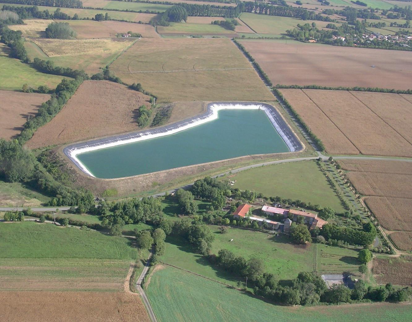
A mega reservoir showing low water levels, Mignon catchment area, western France.
PCHELINA RESERVOIR, BULGARIA
The operation of the Pchelina hydropower plant without ecological flow regime endangers the Struma river’s ecosystem
SUMMARY
The operation of the Pchelina hydropower plant was initiated in 2016 without a prior environmental impact assessment and without establishing ecological flows. This led to an immediate dry-out of the reservoir and of the Struma River downstream of the reservoir. As polluted water from the reservoir was released, the water permit was cancelled in 2021 and the hydropower operation halted. While the condition of the Struma River ecosystem has since started to improve, the case stands as an example for the severe lack of proper ecological flow regimes across Bulgaria.
PERNIK
Pchelina
WHAT’S HAPPENING?
The Pchelina Reservoir was built in 1975 on the Struma River, the largest river in western Bulgaria. The main purpose of the reservoir until the 1990s was as a settling tank for wastewater from the municipality of Pernik, including highly polluted industrial wastewater. Today, the wastewater discharged into the river is still collected in the Pchelina Reservoir. The reservoir is also used for irrigation and industry in Pernik, and it is used by local fishermen and tourist operators. The total volume of the reservoir is 54.8 million m3. Downstream from the Pchelina reservoir, the Struma River flows into the Zemen Natura 2000 site (reference number: BG0001012).
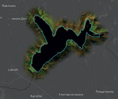
In spring 2016, the private company Power Twenty Twenty Ltd. started operating the Pchelina hydropower plant with a water permit of 89.89 million m3 per year issued by the Ministry of Environment and Water (MOEW). No environmental impact assessment (EIA) was carried out, and no ecological flow regime was established. Due to the activity of the plant, the water level in the reservoir dropped dramatically in June 2016. Fishermen and local people in the area reported dead fish along the shore, the rowing base’s jetty remained dry and there were reports of damaged boats stranded on the bottom.
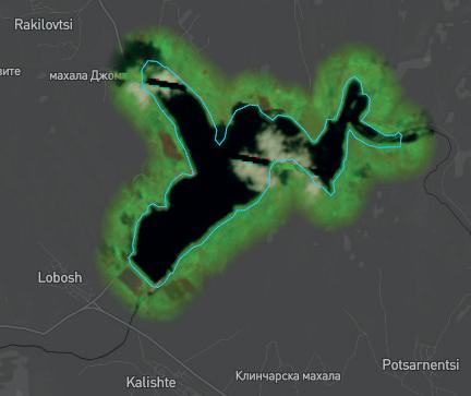
Figure 6: State of the Pchelina reservoir on 31 December 2015 before the hydropower plant started operating (left) and on 16 June 2016 after the start of operations (right). Water is represented in black (Global Water Watch).
At the end of June 2016, the operation of the Pchelina hydropower plant was temporarily stopped. As a result, a negligible amount of water (0.05m3/sec) was released into the Struma riverbed below the dam so the river downstream of the dam almost dried up.
According to the local fishing group, Balkanka, the MOEW had miscalculated the monthly water volumes that could be released from the dam. Balkanka has publicly denounced the hydropower plant’s operation since 2016 and challenged it legally. The plant was allowed to drain 20 million m3 of water for the production of electricity, equaling 7.71m3/sec, which exceeds the average inflow estimated at 3.2m3/sec by far. A minimum volume of 0.5m3/sec of water was to be provided year-round according to the water permit. The excessive drainage at the hydropower plant caused the total volume of water in the reservoir to fall by 12 million m3 in June 2016.
The water from the lower levels of the reservoir was polluted and low in dissolved oxygen, meaning that
the water was not adequate for release. This led to the abstraction permit being amended in October 2016 to 50% of the original volume and a suspension of the operation of the hydropower plant was imposed during low-water conditions, during the fish spawning period, and when the water level in the reservoir was too low. Further obligations were established such as the installation of hydrological monitoring stations and aeration devices to increase the oxygen content of the water.
In 2020, scientific monitoring ordered by the MOEW determined that the operation of the hydropower plant still had a significant negative impact on the ecological status of the Struma River downstream of the Pchelina Reservoir as the water discharged was very low in dissolved oxygen and very high in the pollutant manganese. In July 2021, the MOEW cancelled the water permit for the plant until structural modifications that can prevent the release of polluted waters from the lower level of the reservoir are made. Since then, the hydropower plant has not
been operating and the river is fed entirely through the dam’s spillway. It is reported that the overall biodiversity situation has improved since. A number of fish species have recovered their populations in the area, while other fish species which were abundant in the area, such as trout, are still missing. There is no data on the state of benthic organisms (organisms living in or near the bottom of the water body), so biodiversity restoration in the area cannot be analysed.
In December 2022, the dam operator Power Twenty Twenty Ltd. appealed the cancellation of the water permit, but the appeal court denied the appeal. The court stated that the water permit should not have been issued in the first place and that an environmental impact assessment should have been carried out prior to the implementation of the project. Twenty Twenty Ltd. currently claims economic compensation for the incurred losses. The company has not stated whether it intends to modify the plant according to the conditions imposed by the MOEW and request a new water permit.
WHICH RULES ARE BEING BREACHED?
The operation of the Pchelina hydropower plant breached a number of EU and Bulgarian laws:
No ecological flow regime was adopted for the reservoir. Bulgarian water law stipulates that the minimum ecological flow must be 10% of the annual average water quantity, but not less than the minimum monthly average water quantity at 95% probability. For the Struma River, this would mean a flow of 0.4m3/sec to be released from the Pchelina reservoir, but in reality as little as 0.05m3/sec was released at certain times, representing a grave violation of the ecological flow requirements.
No EIA was considered necessary for the construction of the hydropower plant as it was using an already existing reservoir. Furthermore, no compatibility assessment was conducted in relation to the conservation objectives of the protected area in which the plant is located.
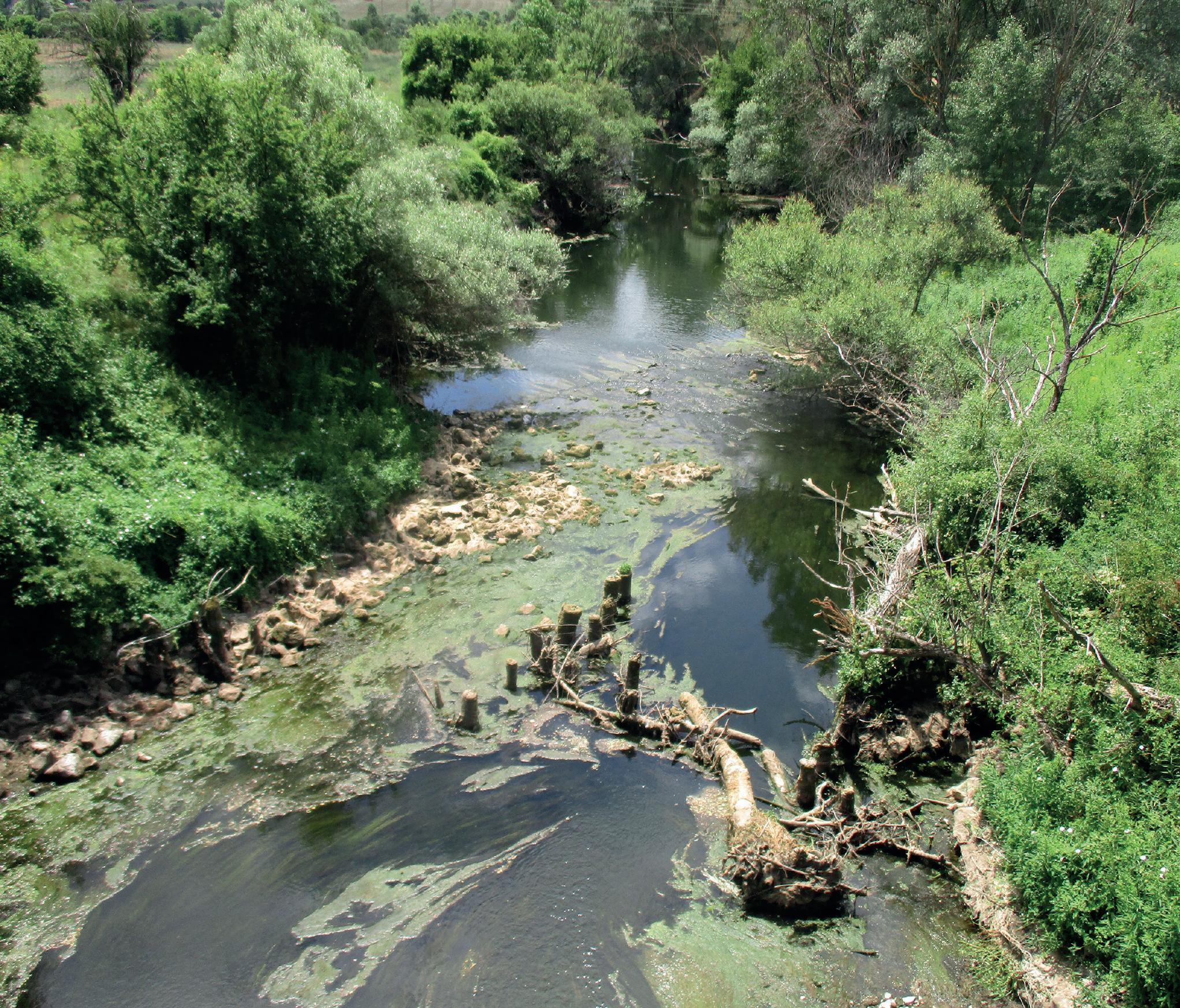
Low flows and eutrophication in the Struma river downstream of the Pchelina reservoir, July 2016.
© Balkanka
The River Basin Management Plan (RBMP) at the time prohibited the construction of hydropower plants for the Struma River downstream from the Pchelina reservoir as well as other activities that have a negative impact on the hydrological regime of the water body, since it is located in a Natura 2000 site.
The dam was drained during the spawning period, violating the prohibition set out in the national Fisheries and Aquaculture Law.
HOW IS THE AREA CHANGING?
The Struma River is a transboundary river flowing southwards into Greece, and its catchment area is also shared with Serbia and North Macedonia. In Bulgaria, it falls within the West Aegean River Basin District. According to the RBMP, the water body after the Pchelina reservoir is assessed as being in unsatisfactory condition in terms of ‘good ecological status’. This is where the Zemen Natura 2000 site lies. With an extension of 178 km2, it includes the Zemen Gorge, one of the few places where the valley of a big river is not populated and there are no roads. The site protects limestone habitats, most with a high diversity of protected plant species. The site is an ecological corridor for protected fish and bat species, and it protects one of two remaining viable populations of land tortoises in the mountains surrounding the Radomir floodplain.
KEY TAKEAWAYS
The Pchelina case demonstrates the lack of proper ecological flow regimes in Bulgaria, and it is just one example of many such cases all over the country. Across Bulgaria, there are a number of violations of ecological flow requirements by operators of hydropower plants. In order to meet the legal requirements, their permits would need to be reduced significantly, only allowing operation for two months of the year or being completely cancelled. However, these violations are difficult to prove, and the associated fines for non-compliance are minor. A large part of these violations are committed in Natura 2000 areas, but so far there are no investigations by the prosecutor’s office that have resulted in a court indictment.
The Pchelina case also illustrates the close interlinkages between water quantity and water quality. The fact that the water stored in the reservoir (particularly at the lower level) is severely polluted not only limits its potential productive uses, but also reduces the options for releasing water into nature. Adequate ecological flow methodologies need to take this kind of site-specific condition into account. Merely referring to percentages of average annual and monthly flows as stipulated in Bulgarian water law is inadequate.
THE HOLTINGERVELD, THE NETHERLANDS
Intensive water use for floriculture and other crops threatens the ecosystem of a protected heathland
SUMMARY
Natura 2000 area, the Holtingerveld (province of Drenthe, The Netherlands) is surrounded by agricultural lands, including intensive floriculture. Groundwater extraction, drainage and the use of pesticides pose a threat to the conservation and improvement of nature and associated ecosystem services.
Wap s e rveensche Aa
Oude Vaartriver
Holtingerveld Natura 2000 site
WHAT’S HAPPENING?
The Holtingerveld is a Natura 2000 site in the province of Drenthe (reference NL9801071). It covers an area of around 1,800 hectares and accommodates several vulnerable species such as the broad yellow-margined predatory beetle, and habitats which depends on its water resources. It is surrounded by agricultural lands, on which floriculture in particular (e.g. lilies and peonies) has been expanding in recent years.
Floriculture requires a highly intensive use of water and land, involving drainage, groundwater extraction for irrigation, annual or biennial top soil removal and the use of many pesticides. Floriculture does not only destroy the local landscape, but has negative impacts on the adjacent Natura 2000 area and its ecosystem. Apart from the pesticides that are found far from the flower fields, groundwater levels have lowered and water is leaking away from the Holtingerveld.
In 2018, NGOs and nature conservation groups found out that provincial authorities had not requested an appropriate assessment of the impacts of groundwater abstraction and use of pesticides for lily farming on nature, as required under the Habitats Directive. The provincial authorities only requested a superficial document (‘voortoets’) which ‘assumed’ no negative effects are happening and disregarded cumulative effects. This meant that new groundwater extractions and agricultural activities were not analysed under the requirements of the EU’s Nature Directives. Moreover, a comprehensive mapping of wells was not available.
On 31 March 2018, The NGO MilieuDefensie sent a first enforcement request of the Dutch Nature Conservation Act to the province of Drenthe, asking the province to stop the drainage works for the preparation and cultivation of lilies in the vicinity of the Holtingerveld Natura 2000 site, due to the absence of an appropriate assessment. The Province rejected the request in July, arguing that the drainage did not affect the aquifer, although it might have a hydrological effect on the groundwater level in the Natura 2000 area. In August, Milieudefensie objected the decision, but their objection was rejected.
In 2019 and 2020, Milieudefensie filed several appeals and supplementary appeals in Court against the rejection of their objection. The province continued to use the defence line that in the absence of significant negative effects of lily cultivation on the conservation objectives of the Natura 2000 site, no permit requirement applied. It was only on 18 June 2021, that the District Court of the Northern Netherlands ruled that the province of Drenthe had not fulfilled its duty to investigate the impacts of lily farming on the Natura 2000 site and that in particular, the cumulative aspects of drainage were not investigated, and obliged the Drenthe Province to change the issuing of permits for water extraction to comply with the Habitats Directive Articles 6(2) and 6(3). However, the province has appealed the decision and the final decision is still expected.
In the meantime, extractions are growing, and intensive agriculture is expanding. The objectives of the management plans for the Natura 2000 site are not met and there is evidence that habitats are deteriorating because of the increasing water abstraction combined with the use of pesticides.
A scientific assessment commissioned by the Drenthe Province identified desiccation as one of the main three pressures on the Natura 2000 site, together with nitrogen deposition and alterations in sand drifting. Drainage and groundwater abstraction outside the area were found to negatively affect the groundwater level within the area, especially along the edges. As a result, less water is available in dry times, causing fens and forests to dry up, and wet heath to turn into dry heath53. Wet heath (habitat type H4010, under the Habitats Directive) is the habitat in the poorest state in the Natura 2000 site, and there are signs it is continuing the deteriorate. The lack of water is causing the overgrowth of a few dominant types of grass which displace the other plants, and impact species living in sandy soils.
An assessment of the ecological state of Holtingerveld conducted in 2020 by Natuurmonumenten, covering the period 2014-2020, confirmed that hydrological disturbances were among the main problems impacting the conservation of the site. Groundwater levels were found to drop too far in summer, with excessive fluctuations between summer and winter water levels. The dry conditions on the heathland were also found to negatively affect breeding birds54. The number of insects have fallen dramatically in the nature reserves in Drenthe: ground beetle populations have fallen by 4.34% on average per year in the period 1985-2017, with a steeper decline starting after 1995 (on average 5.6% annually)55 .
There are reports of cocktails of chemicals found in the heart of the Holtingerveld, while water extractions are growing.
WHICH RULES ARE BEING BREACHED?
The Netherlands has a permitting and register system in place for groundwater abstraction. Groundwater abstraction for agriculture should be reported to and authorised by the water board. If happening within 200 metres from a Natura 2000 site, it should also be reported to the Province, which should then assess the impacts of groundwater abstraction on the Natura 2000 site.
In the Holtingerveld, the Drenthe Province failed to request the appropriate assessment required under the Habitats Directive to make sure that the abstraction would not affect the Natura 2000 site. The regional Court “Rechtbank Noord Nederland” ruled that the overexploitation of the Holtingerveld breaches both the non-deterioration obligation set out in Article 6(2) of the Habitats Directive, and Article 6(3) of the Habitats Directive which establishes a permitting procedure for any plans or projects that are likely to have a significant effect on one or more sites.
Currently available information does not allow for the identification of any breach of the Water Framework Directive. In the River Basin Management Plan 2022-2027 for the Rhine-East, the groundwater quality appeared overall as “good” in 2020 at the scale of the Sand RhineEast groundwater body. However, the RBMP also shows that target values for the groundwater-dependent surface water bodies, drinking water resources, and groundwaterdependent terrestrial ecosystems were not reached in 2020, which suggests irregularities in the quantitative status of some water bodies locally. The Holtingerveld specifically appears as an area where the groundwater level is too low to sustain terrestrial ecosystems – together with 25 other Natura 2000 sites in the Sand Rhine-East catchment (six of those are in the Drenthe Province). Besides, the Wapserveensche Aa river flowing NorthWest of the Holtingerveld appears as a river where the insufficient groundwater inflow results in insufficient river discharge – together with 22 other surface water bodies in the catchment. The RBMP notes that “it will be examined to what extent adjustments within the river basin will result in an increase of the supply of groundwater56.” Several measures are listed in the Province of Drenthe, including analyses of groundwater and drinking water abstraction points, “other development measures” linked to
terrestrial ecosystems which are not described, controls of pesticide use and measures to reduce agricultural nutrient emissions, but it remains to be seen whether they will be implemented and whether they will actually impact the Holtingerveld. Even if they are implemented, these proposed measures are not adequate and sufficient to meet the Water Framework Directive requirements, and are not likely to result in an increased supply of groundwater.
HOW IS THE AREA CHANGING?
The Holtingerveld is part of the Dutch national nature network. It is 17.82 km2 in size and designated as a Natura 2000 area for its heathland grasslands, dry heaths and crowberry vegetation. In addition, the area is famous for its special subsoil, very rare plants occur – especially in the heathland grasslands – that have virtually disappeared elsewhere in the Netherlands57. Partly because of this, nature in Holtingerveld is of great national and international importance.
Unsustainable water and soil use in the Holtingerveld should also be seen in the wider context of poor water management and pesticide use in the Netherlands. Only
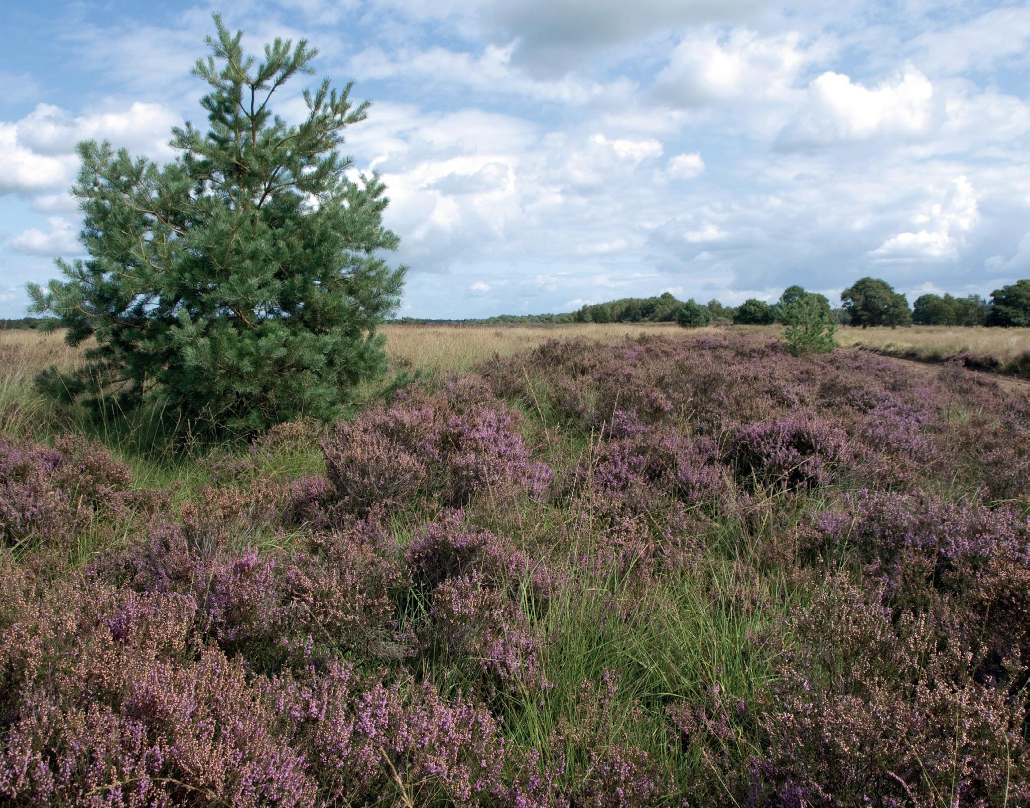
The Holtingerveld Natura 2000 site, northern Netherlands
25% of surface water bodies in the Netherlands are in good chemical status, and none are in good ecological status. Overfertilization with nitrogen and phosphorus, and pesticide use, are among the main causes58. Only 60% of groundwater bodies are in good chemical status, with elevated nitrate concentrations as the main issue59
Even though it is not strictly connected to the Holtingerveld case, it should also be noted that the Netherlands is the only EU Member State which does not have any register for water abstraction from surface water (only for groundwater), although this is required by the Water Framework Directive60. While this register and a permitting system exist for groundwater, managed by Water Boards, NGOs observe that the authorisation systems often do not function, and that many farmers do not use it. In its report on the implementation of the second RBMPs in the Netherlands, the European Commission also noted that small abstractions are exempted from permitting and controls61.
KEY TAKEAWAYS
The Holtingerveld case illustrates dysfunctional controls on groundwater extraction in The Netherlands, especially in and around Natura 2000 sites. Adequate registration of extracted volumes and enforcement of rules are lacking, a legal assessment of the impacts of new abstraction activities is not always carried out, and when it is, it often does not take into account the cumulative negative effects of groundwater extractions on ecosystems. Further, the present land-use policies do not prevent intensive agricultural exploitation in the vicinity of Natura 2000 areas in many regions in The Netherlands.
Although the scientific assessment commissioned by the Drenthe Province states that several measures have been secured in the coming period to further improve hydrology in the Holtingerveld62, most of them are minor interventions in a couple of ponds and NGOs doubt their scope is actually sufficient to recover the heaths.
60% OF DUTCH GROUNDWATER BODIES ARE IN GOOD CHEMICAL STATUS.
THE WAY FORWARD
Water mismanagement is the root cause for water scarcity problems across Europe, which are being compounded by climate change and land-use transformation. Water management must be improved, since decisions supporting uncontrolled and unsustainable water abstractions as well as water impoundments worsen an already worrying hydrological situation.
Water scarcity is not a natural event, but a result of bad water management. Good quality water, both surface and groundwater, is a precious and vital common good for nature and people that Europe should be committed to protect, keep healthy, and use sustainably.
In order to address, prevent and adapt to water scarcity, we believe that:
● Retaining water in the landscape to foster infiltration, and preserving and restoring freshwater ecosystems to a near-natural state, such as free-flowing rivers, are key nature-based solutions to resilient water management.
● Reducing excessive water demands, from agriculture, but also urban areas or industries, and supporting soil health and permeability have an important role to play. They also benefit other policy objectives (e.g. biodiversity, flood protection etc.).
● Resilient water management requires the contribution of all sectors and water users, and strong policy coordination.
● Achieving the objectives and fundamentals of the Water Framework Directive, including the “rational utilisation of natural resources” mentioned in the EU treaties, needs to be a cornerstone of all relevant EU national policies.
● Decisions on how to allocate water resources need to take into account uncertainties derived from climate change impacts. In this regard it seems more important than ever to endorse the precautionary principle stated in Article 191 of the Treaty on the Functioning of the European Union, that aims to ensure a high level of environmental protection through preventative action.
The case-studies outlined above reveal several water mismanagement issues: illegal, excessive and/or insufficiently controlled water abstraction for agriculture (Doñana; Holtingerveld); illegal filling and operation of water reservoirs for agriculture only benefiting 12 farmers (Mignon catchment); illegal construction and irregular operation of hydropower plants without a proper ecological flow regime (Pchelina).
RECOMMENDATIONS FOR THE EUROPEAN INSTITUTIONS: DRIVE A STRONG WATER AND CLIMATE ADAPTATION AGENDA
This agenda should make full use of all the legal tools available in existing legislation, such as the Water Framework Directive, and include the following measures:
1. The European Commission should request Member States to designate hydrological reserves, including natural lakes, rivers and groundwater reserves, where abstractions are either prohibited or limited as much as possible and only for drinking water. This can be done in the framework of the Water Framework Directive, which requires Member States to identify water bodies used for drinking water abstraction, make sure they meet the objectives set in Article 4 and in the Drinking Water Directive, and ensure their necessary protection (WFD, Article 7). The Directive mentions that “Member States may establish safeguard zones for those bodies of water” (WFD, Article 7(3)), which is already done in Spain (see “groundwater hydrological reserves in Spain” below) and in most basins in metropolitan France63 (read one example, “the Loire-Bretagne river basin, France” below).
INSPIRATIONAL EXAMPLES
GROUNDWATER HYDROLOGICAL RESERVES IN SPAIN
In 2005, river nature reserves were introduced in the Water Law (Article 42), “with the purpose of preserving, without alterations, those sections of rivers with little or no human intervention.” The law mandates that all River Basin Management Plans designate such river nature reserves, as reference rivers under the Water Framework Directive. In 2017, there were 135 reserves totalling 2669 km of river64. For the first time in 2022, the government added 19 lake nature reserves (12 km2) and 2 groundwater nature reserves (1,000 km2) to this list, now totalling 289 reserves and more than 3,848 km of watercourses. Currently, the law states that no new water concession can be granted (except in case of emergency for urban water supply), and that no activities shall be permitted that might affect the hydromorphological conditions and other natural properties of the river. It is not clear yet what this will imply for the new groundwater reserves.
Source: Ministry for Ecological Transition and the Demographic Challenge, Spain
GROUNDWATER HYDROLOGICAL RESERVES IN THE LOIRE-BRETAGNE RIVER BASIN, FRANCE
Groundwater bodies prioritised for drinking water have existed in the Loire-Bretagne Basin since 1996. In 2022, at the request of the Regional Health Agency, river basin authorities decided to include additional aquifers reserved for drinking water supply in the 2022-2027 River Basin Management Plan, in order to extend the protection of groundwater resources which currently are in a relatively good status. In these reserved aquifers called “nappes d’eau réservées à l’approvisionnement en eau potable”, or NAEPs in French, additional abstractions are only for drinking water. New abstractions for other uses may only be accepted under limited conditions: to replace existing abstractions in the same reservoir and the same sector, and in the absence of a quantitative deficit of the water table. The RBMP states that management plans should then be drawn up with relevant stakeholders, in order to specify which other abstractions may be permitted in the future, and recommend actions to preserve the quantitative balance of the aquifer, based on foreseeable trends in water abstraction and their medium-term impact on the water table level.
Source: 2022-2027 RBMP Loire-Bretagne, Measure 6E, pp. 91-97.
2. The European Commission should request Member States to ensure the implementation of ecological flow regimes, and to adapt water allocation schemes taking into consideration climate change impacts and needs for adaptation, based on the CIS-guidance on ecological flows in the implementation of the Water Framework Directive. In particular, the Commission should release technical guidance for Member States on their measures to review water abstraction and impoundment permits and to restore ecological flows in the revised River Basin Management Plans. This was a commitment included in the EU Biodiversity Strategy 2030. This guidance should, among other elements:
i) Clarify how to define the significance of the impacts of water abstractions, taking into account the cumulative impacts of several abstractions, and other environmental legislation including the Nature Directives.
ii) Stress that flood prevention measures, including those included in Flood Risk Management Plans, should be harmonised with the water scarcity and drought prevention measures included in River Basin Management Plans.
3. The European Commission must enforce existing legislation, including the WFD and the Nature Directives. The case studies displayed above show several examples of breaches or poor implementation, which the Commission needs to act upon by taking appropriate legal action and when reviewing the third River Basin Management Plans and second Flood Risk Management Plans. In particular, the European Commission should ask Member States to thoroughly justify any exemptions used in River Basin Management Plans from the requirements for having periodically updated registers and authorisations for water abstraction. If not, Member States should explain why they concluded that abstractions do not
have a significant impact on the status of water bodies, as recommended by the Court of Auditors in 202165
4. The European institutions should work towards the timely adoption of an ambitious EU Nature Restoration Law as freshwater habitats, free-flowing rivers, and restored wetlands help keep water in the landscape. Please refer to WWF recommendations.
5. The European Commission should phase out subsidies and funds which are harmful to water resilience, so that no projects and/or activities leading to the worsening of water scarcity can receive EU funding. In this regard it is important to ensure that efficiency measures (e.g. modernisation of irrigation) reduce water abstraction pressures and contribute to improving the status of water bodies. Thus, this should include the elimination of CAP payments that support water-intensive crops or the increase of irrigation in areas at risk of or suffering from water stress; the continuation of the phase-out of CAP payments for land drainage for agriculture; and the phase out of any subsidies for reservoirs which do not meet the conditions outlined in the recommendations for Member States, point 1. The European Commission should assess whether Member States have correctly applied the post-2020 CAP rules so that funded irrigation projects do not deteriorate the status of water bodies nor hinder climate change adaptation capacity due to mal-adaptation practices (e.g. intensification of water consumption); and in general assess the impact of rural development funding on water use and pollution.
6. The European Commission should design a strategy for a water-resilient agriculture in Europe as a follow-up to the “Farm to Fork” package, including the development of further incentives for using natural water-retention measures such as, among others, small ponds for water infiltration, remeandering, wetlands restoration and management, etc66. and measures to promote agroecology. Rural development funds, especially in the regions suffering from or at risk of water scarcity, should be earmarked for the production of food for people, and for sustainable agricultural practices that help to recover soils, rivers, wetlands and aquifers avoiding overexploitation and further deterioration of water bodies due to increases in the use of pesticides and artificial fertilisers. The implementation of natural water retention measures and measures related to protecting water quality should be a more systematic requirement to access EU funds under the CAP, but also across other policy fields.
RECOMMENDATIONS FOR NATIONAL GOVERNMENTS:
1. Any new impoundments such as water reservoirs need to be conditional to an Article 4.7 test under the Water Framework Directive, including a proper justification. Before planning any reservoir, a consultation process must be carried out. Alternative options that are a better environmental solution, such as natural water retention measures and sustainable agriculture (aiming to improve soil health and permeability) need to be prioritised to improve water retention in the landscapes and in the aquifers, even if this means a strategic “shift” e.g. towards lower intensity, sustainable agriculture. The shared benefits of impoundments should also be a decisive criteria, in order to avoid spending a lot of public funds that only benefit a tiny minority of end-users. No artificial impoundments or reservoirs (other than natural water retention measures) should be built in or impact protected rivers, wetlands and habitats, including Ramsar sites, Natura 2000 sites, ecological corridors, and other types of protected areas recognised at local, national or international level. In Member States where impoundments generate intense conflicts, a moratorium on any new impoundments could be considered for a period of two or three years, in order to provide time for general and substantial consultation.
2. Member States should have authorisation regimes and regularly updated registers for all types of water abstractions including small ones. When granting authorisations for water abstraction, Member State authorities should systematically take into account the status of the water body concerned, and the foreseeable trends in water availability. This should include the expected effects and uncertainties resulting from climate change, as well as the direct and indirect impacts of the abstraction on the water body (including on the ecological status of the surface water body, i.e. fish populations, and the quantitative status of the groundwater body). Water planning needs to include a climate change uncertainty analysis, in order to define risk scenarios that can help set the maximum annual (or monthly) quantity that may be abstracted.
GOOD QUALITY
SURFACE
AND GROUND WATER IS A PRECIOUS AND VITAL COMMON GOOD THAT EUROPE SHOULD PROTECT
3. Upon its adoption, Member States need to transpose the upcoming Environmental Crime Directive (replacing 2008/99/EC) in a timely and effective way. The directive adds illegal water abstraction from ground- or surface water to the list of criminal offences. In particular, Member States need to ensure that all the legal instruments foreseen by the Directive are used to provide effective, proportionate and dissuasive sanctions for all offenders, and to prevent further breaches of the Water Framework Directive (e.g. via the establishment of national strategies on combating environmental criminal offences required by Art. 20).
REFERENCES
1. WEI+ measures water consumption as a percentage of the renewable freshwater resources available at river subbasin level and by each of the four quarters of the year (3 consecutive months). WEI+ values above 20% indicate that water resources are under stress and therefore water scarcity conditions prevail; values above 40% indicate that stress is severe and freshwater use is unsustainable.
2. European Environmental Agency, What could the summer bring? Is extreme weather the new normal? 2023.
3. European Environmental Agency, Drought impact on ecosystems in Europe, 2000-2021, dashboard, 2021.
4. European Environment Agency, Water resources across Europe — confronting water stress: an updated assessment, 2021.
5. Free, G., Van De Bund, W., Gawlik, B., Van Wijk, L., Wood, M., Guagnini, E., Koutelos, K., Annunziato, A., Grizzetti, B., Vigiak, O., Gnecchi, M., Poikane, S., Christiansen, T., Whalley, C., Antognazza, F., Zerger, B., Hoeve, R. and Stielstra, H., An EU analysis of the ecological disaster in the Oder River of 2022, Publications Office of the European Union, Luxembourg, 2023, doi:10.2760/067386, JRC132271.
6. Eureau, Europe’s Water in Figures An overview of the European drinking water and waste water sectors. 2021 Editions.
7. European Environment Agency, Water resources across Europe — confronting water stress: an updated assessment, 2021, figure 4.6.
8. Dartmouth College, “Unprecedented’ changes to world’s rivers: Results quantify how construction of dams and land use change alters sediment flux to oceans” ScienceDaily. ScienceDaily, 29 June 2022.
9. A study from INRAE, France, shows that with a healthy soil under conservation agriculture, infiltration is multiplied by 2 to 4 compared to a soil on conventional agriculture : Alletto et al., Physical properties of soils under conservation agriculture: A multi-site experiment on five soil types in south-western France, 2022.
10. The study analysed the 1972 largest global lakes using three decades of satellite observations, climate data, and hydrologic models. Source: Fangfang Yao et al., Satellites reveal widespread decline in global lake water storage Science380,743-749(2023). DOI:10.1126/science.abo2812.
11. Directive 2000/60/EC
12. In Germany, only slightly less than 10% of rivers, lakes and coastal waters are in good ecological status.
13. European Environment Agency, European waters Assessment of status and pressures 2018, 2018.
14. Living Rivers Europe 2021, The final Sprint for Europe’s Rivers - An NGO Analysis of 2022-2027 Draft River Basin Management Plans, 2021.
15. Pinke, Z., Long decline in soil moisture urges restoration of European wetlands. 2022: Global Land Programme.
16. Fluet-Chouinard, Etienne & Stocker, Benjamin & Zhang, Zhen, et. al. (2023). Extensive global wetland loss over the past three centuries. Nature. 614. 281-286. 10.1038/s41586022-05572-6.
17. European Environment Agency, Water resources across Europe - Confronting water stress: an updated assessment, 2021.
18. The Standardized Precipitation and Evaporation Index (SPEI) is a multi-scalar drought index applying both precipitation and temperature data to detect, monitor and analyze different drought types and impacts in the context of global warming. This risk indicator was computed using the monthly time series of the SPEI 36-month time scale and applying the relative frequency approach – the ratio of the number of months when the index is below or equal to events of moderate magnitude (SPEI < -1) to the total number of possible outcomes.
19. IPCC 2018. Special Report Global Warming of 1.5 ºC
20. European Environmental Agency, What could the summer bring? Is extreme weather the new normal? 2023.
21. For instance, in the Guadalquivir river basin, the exploitation index of the basin is 0,55 (data from 2021). This translates into 6,921 hm3/year as resources versus 3,774.24 hm3/year of water demands. From these demands, 3,163,42 hm3/year are dedicated to irrigate 875,414.11 hectares. Source: River Basin Management Plan for the Guadalquivir Basin, 2022.
22. For more information, please refer to: www.oecd.org/ environment/implementing-water-economics-in-the-euwater-framework-directive-d6abda81-en.htm
Source: EU Court of Auditors, Sustainable water use in agriculture: CAP funds more likely to promote greater rather than more efficient water use, 2021.
23. European Environmental Agency, Surface water significant pressures and impacts, WISE database, 2018.
24. European Environment Agency, European waters Assessment of status and pressures 2018, 2018.
25. WWF, Sustainable Groundwater Management for Agriculture, 2022.
26. Ibid.
27. WFD Annex V 2.1 describes the hydrological regime in the definition of ecological status.
28. European Commission, Ecological flows in the implementation of the Water Framework Directive, Technical Report, 2015- 086.
29. European Commission, EU policy document on Natural Water Retention Measures, Technical Report, 2014- 082
30. European Commission, Ecological flows in the implementation of the Water Framework Directive, Technical report, 2015- 086.
31. European Commission, Report from the Commission to the Council and the European Parliament on the implementation of the Water Framework Directive (2000/60/EC), the Environmental Quality Standards Directive (2008/105/EC amended by Directive 2013/39/EU) and the Floods Directive (2007/60/EC)
32. CIRCABS 2023 “Implementing the WFD and the Floods Directive” (https://circabc.europa.eu/ui/group/9ab5926dbed4-4322-9aa7-9964bbe8312d/library/b44c5c7a-508f4800-91a4-9acc99c4eec4?p=1&n=10&sort=modified_DESC).
33. European Commission, Report from the Commission to the Council and the European Parliament on the implementation of the Water Framework Directive (2000/60/EC), the Environmental Quality Standards Directive (2008/105/EC amended by Directive 2013/39/EU) and the Floods Directive (2007/60/EC), page 10.
34. EU Commission Technical Report - 2011 - 056 “Groundwater dependent terrestrial ecosystems” (https://circabc.europa. eu/sd/a/0500f8ef-d16b-4086-a152-d783d19bb0b8/ Technical_report_No6_GWDTEs.pdf).
35. European Commission, Guidance on The requirements for hydropower in relation to Natura 2000, 2018.
36. Good Ecological Potential.
37. Greenpeace, Feeding the problem, The dangerous intensification of animal farming in Europe, 2019.
38. Heinrich Böll Stiftung, Friends of the Earth Europe, Bund, Meat Atlas 2021, 2021.
39. EU Court of Auditors, Sustainable water use in agriculture: CAP funds more likely to promote greater rather than more efficient water use, 2021, page 32.
40. Regulation (EU) 2021/2115 of the European Parliament and of the Council of 2 December 2021 establishing rules on support for strategic plans to be drawn up by Member States under the common agricultural policy (CAP Strategic Plans), Article 74.
41. European Environmental Bureau, Soil and carbon farming in the new CAP: alarming lack of action and ambition, 2022.
42. WWF 2022 “A Lost Decade: Report on the state of the Doñana Aquifer” (https://wwfes.awsassets.panda.org/ downloads/wwf_report_donana_aquifer_2020_en__1__1. pdf).
43. WWF 2021 “EU court rules Spain at fault over degradation of Doñana” (www.wwf.eu/?3877416/EU-court-rules-Spain-atfault-over-degradation-of-Donana).
44. Sentencia del Tribunal de Justicia 2021 (https://eur-lex.europa.eu/legal-content/ES/ TXT/?uri=CELEX%3A62019CJ0559).
45. Confederación Hidrográfica del Guadalquivir 2022 “La CHG notifica el cierre de 7 nuevos pozos por ejecución forzosa en el entorno de Doñana (www.chguadalquivir.es/-/la-chgnotifica-el-cierre-de-7-nuevos-pozos-por-ejecucion-forzosaen-el-entorno-de-donana).
46 Comunidades de Usuarios de Aguas Subterráneas.
47. WWF 2023 “Doñana emergency: European Commission must stop destructive law” (www.wwf.eu/what_we_do/ biodiversity/?10136966/Donana-emergency-EuropeanCommission-must-stop-destructive-law).
48. In a strong letter sent to the Ambassador Permanent Representative of Spain to the European Union on 20 March 2023, the Director General of DG Environment affirmed that the Commission was monitoring the situation and would consider taking all necessary measures, including bringing further action before the Court of Justice requesting the imposition of financial penalties, if the law is adopted in its current terms.
49. Schéma d’Aménagement et de Gestion de l’Eau – SAGE.
50. Thompson 2023 “What are France’s ‘mega reservoirs and why are they so controversial?” (www.connexionfrance.com/ article/French-news/What-are-France-s-mega-reservoirsand-why-are-they-so-controversial).
51. Barroux 2023 “Protesters, police injured after violent clashes over water reservoir protest in France” (www. lemonde.fr/en/france/article/2023/03/26/protesters-policeinjured-after-violent-clashes-over-water-reservoir-protestin-france_6020731_7.html).
52. Thompson 2023 “Go-ahead for controversial ‘mega reservoirs’ in west France” (www.connexionfrance.com/ article/French-news/Green-light-for-controversial-megareservoirs-in-western-France).
53. Province of Drenthe, Concept Natuurdoel-analyse Holtingerveld, p. 61.
54 J. de Bruin, R. Martens en H. Krol, 2020, Holtingerveld Kwaliteitstoets 2014-2020. Rapport Natuurmonumenten, Ruinen.
55. Caspar A. Hallmann, Theo Zeegers, Roel van Klink, Rikjan Vermeulen, Paul van Wielink, Henk Spijkers & Eelke Jongejans, Analysis of insect monitoring data from De Kaaistoep and Drenthe, 2018.
56. Factsheet KRW - Stroomgebiedbeheerplan 2022-2027, Waterlichaam: Zand Rijn-Oost, pages 7-9.
57. Province of Drenthe, Beheerplan Holtingerveld, 2016.
58. Government of The Netherlands, Quality surface water, 2019, dashboard, 2021.
59. Government of The Netherlands, Situation of groundwater, webpage accessed on 4 July 2023.
60. European Commission, Report from the Commission to the Council and the European Parliament on the implementation of the Water Framework Directive (2000/60/EC), the Environmental Quality Standards Directive (2008/105/EC amended by Directive 2013/39/EU) and the Floods Directive (2007/60/EC), 2011, page 11.
61. European Commission, Second River Basin Management Plans – Member State: The Netherlands, SWD(2019) 50 final, 2019.
62. Province of Drenthe, Concept Natuurdoel-analyse Holtingerveld, p. 80.
63. Loire-Bretagne, Adour Garonne, Seine Normandie, Rhin Meuse and Rhône Méditerranée Corse.
64. Schäfer, T., Legal Protection Schemes for Free-Flowing Rivers in Europe: An Overview. Sustainability 2021, 13, 6423.
65. EU Court of Auditors, Sustainable water use in agriculture: CAP funds more likely to promote greater rather than more efficient water use, 2021.
66. Examples are provided under http://nwrm.eu/.
TO BUILD A FUTURE IN WHICH
PEOPLE LIVE IN HARMONY WITH NATURE.
2023
recycled © 1986 Panda symbol WWF – World Wide Fund for Nature (Formerly World Wildlife Fund) ® “WWF” is a WWF Registered Trademark. WWF European Policy Office, 123 rue du Commerce, 1000 Brussels. For contact details and further information, please visit our website at www.wwf.eu