PHIMCOS
News & Events
THE FINAL PHIMCOS meeting in 2025, held on 12 November, was attended in person by 27 members and 23 guests, and via Zoom by six members and five guests After dinner Jonathan Wattis gave a presentation on ‘Elizabeth Keith: Pictures of the Philippines in 1924’. Having lived in Japan since 1915, the talented Scottish artist Elizabeth Keith visited the Philippines in 1924, where she painted vivid scenes of places and people which were made into attractive, limitededition woodblock prints and etchings.
Keith’s story is particularly interesting because, as a young woman travelling to remote places, she was able to produce fine quality pictures of her unique vision as a record for posterity. Little has been written about her visit to the Philippines, and Jonathan’s presentation was illustrated with most of her beautiful pictures of Manila, Baguio, Zamboanga and Sulu. His article on the subject was published in Issue No. 20 of The Murillo Bulletin
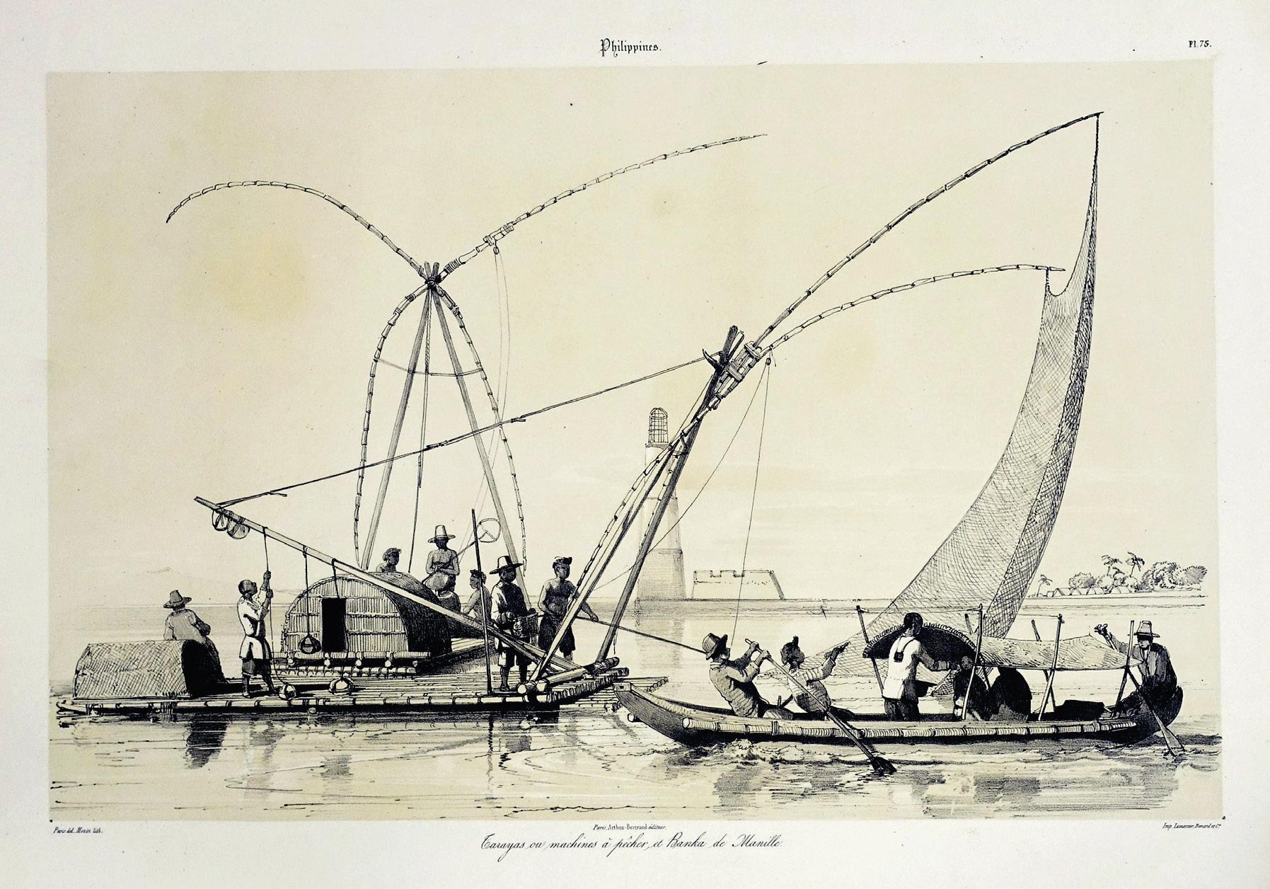
Our second presentation that evening was ‘Mapping Manila Bay: A History in Maps, Memories and Images from the Spanish Encounter to the Present’ by Mark Lim. His detailed talk explained how Manila Bay is central to Philippine history, influencing its settlement, economy, politics and global significance. The bay’s geography as a large, deepwater, natural harbour made it a centre for global trade and a strategic prize for military engagements throughout history.
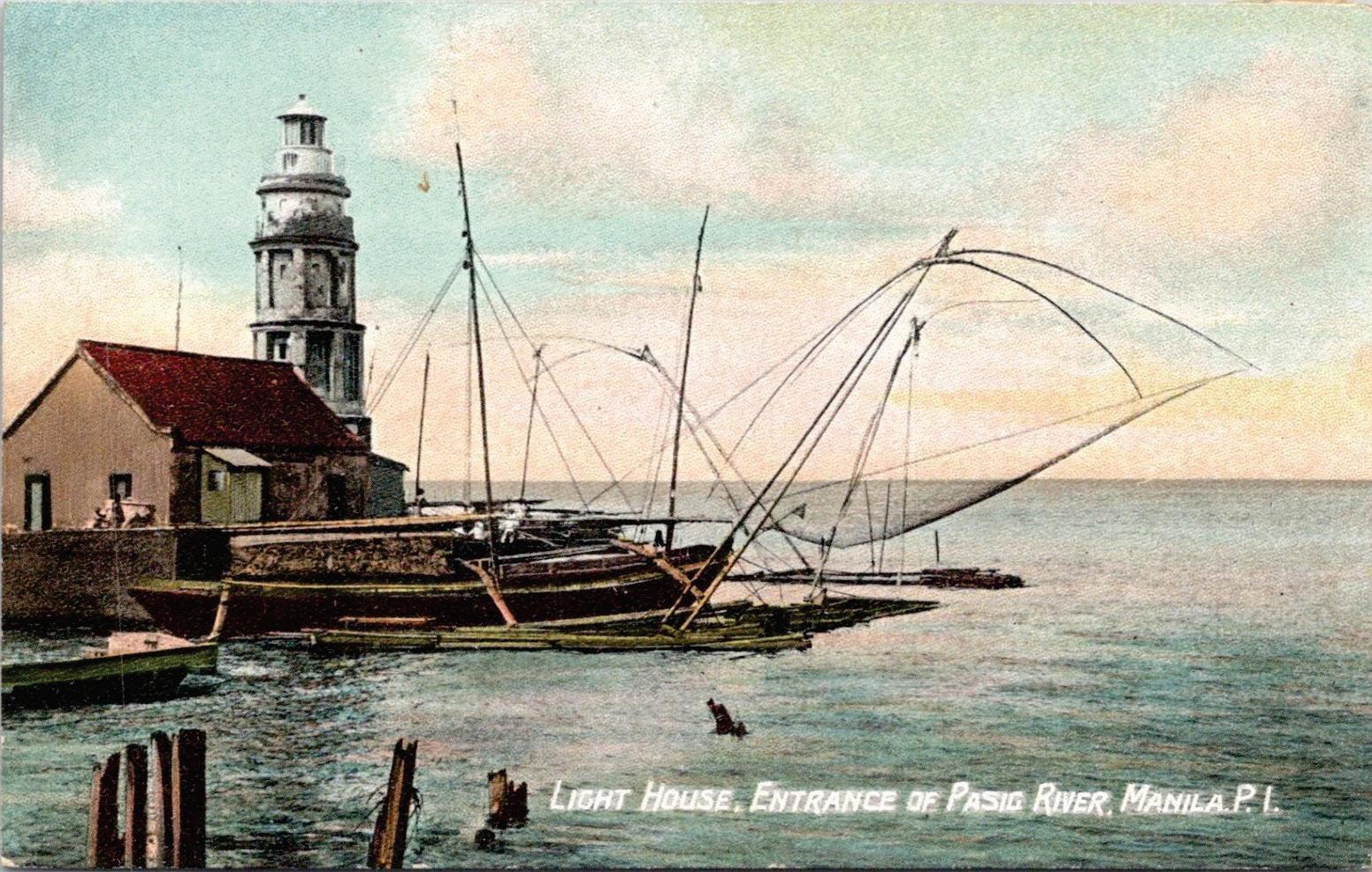
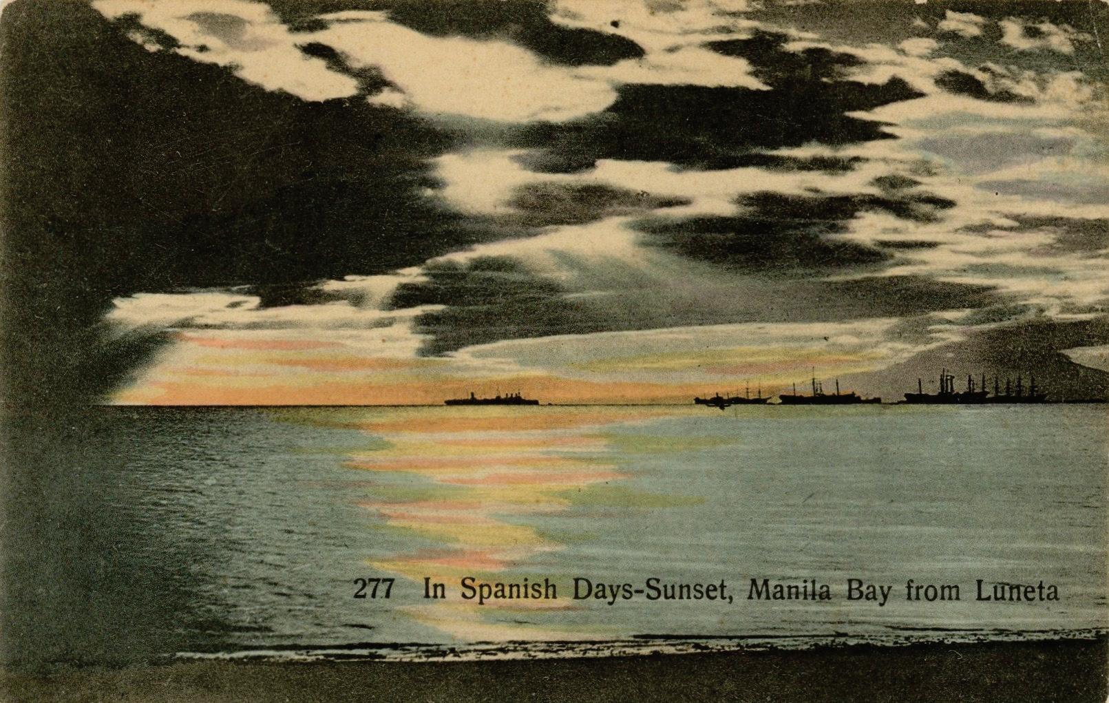
Mark traced the evolution of Manila Bay in the imagination of those who encountered it. He showed how the shape of the bay in maps changed with increasing knowledge over time until recently, when we decided to reshape the bay itself with reclamation. He recounted the impressions of those who entered the bay for the first time, especially during pivotal moments in Philippine history. And he noted how the point of view seen in images of the bay – in prints, paintings, photographs and postcards – has changed over time, enabling us to understand the history of the bay and of the nation. Mark’s article on Manila Bay is on pages 27 to 64
The first meeting of 2026, held on 11 February, was attended in person by 30 members and 26 guests, with three members and three guests joining via Zoom. As this was the PHIMCOS Annual General Meeting, Jimmie González recapped the Society’s activities and accomplishments in 2025: six formal presentations; three show-and-tell sessions; two exhibitions, in Zamboanga and Cebu; a visit to the Manila Observatory; three issues of The Murillo Bulletin; and the approval of ten new members. The President also reported the recent decisions taken by the Board of Trustees, including changes in the board members and confirmation of the officers (see page 68), and asked the members to ratify the nine board resolutions that had been circulated to them.
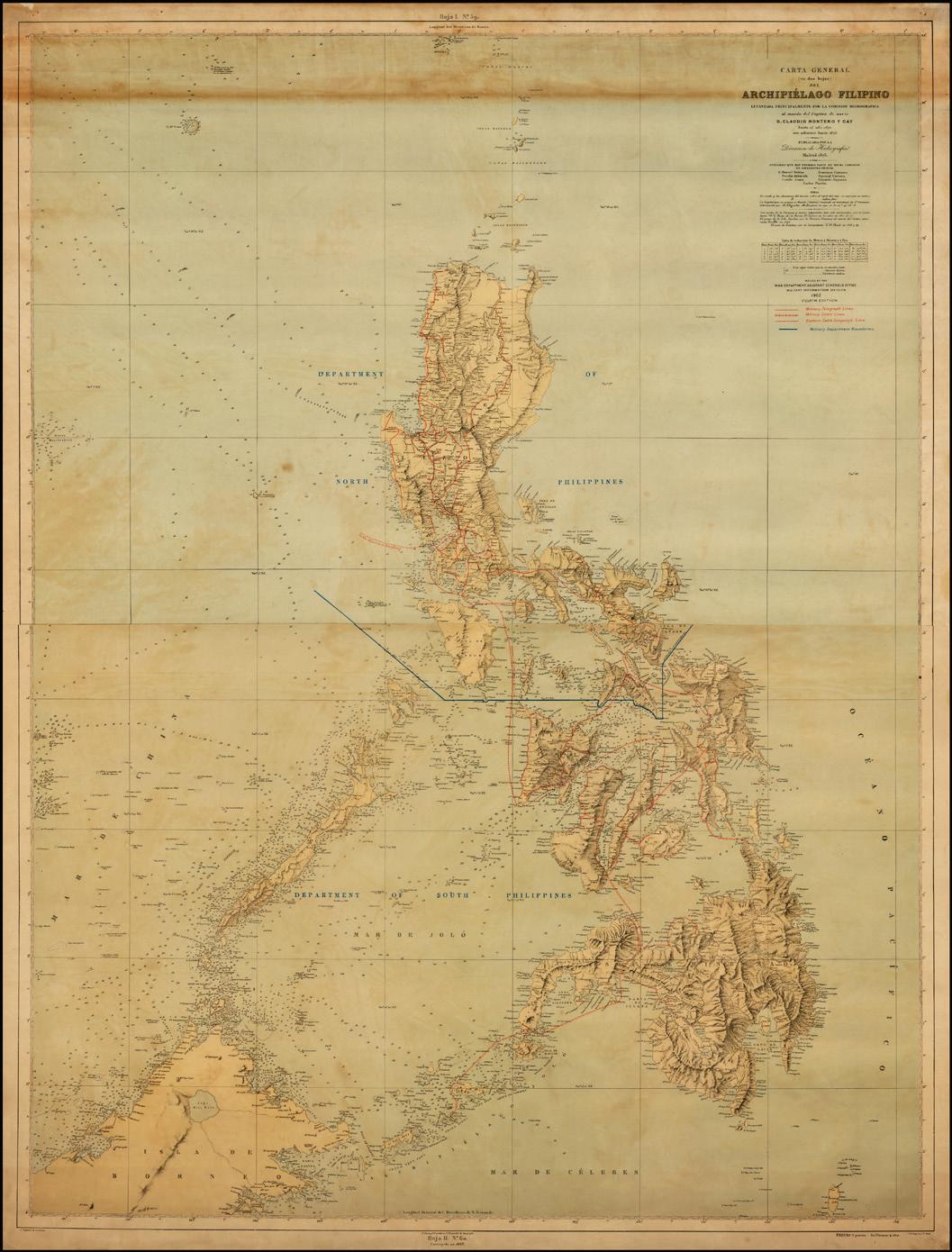
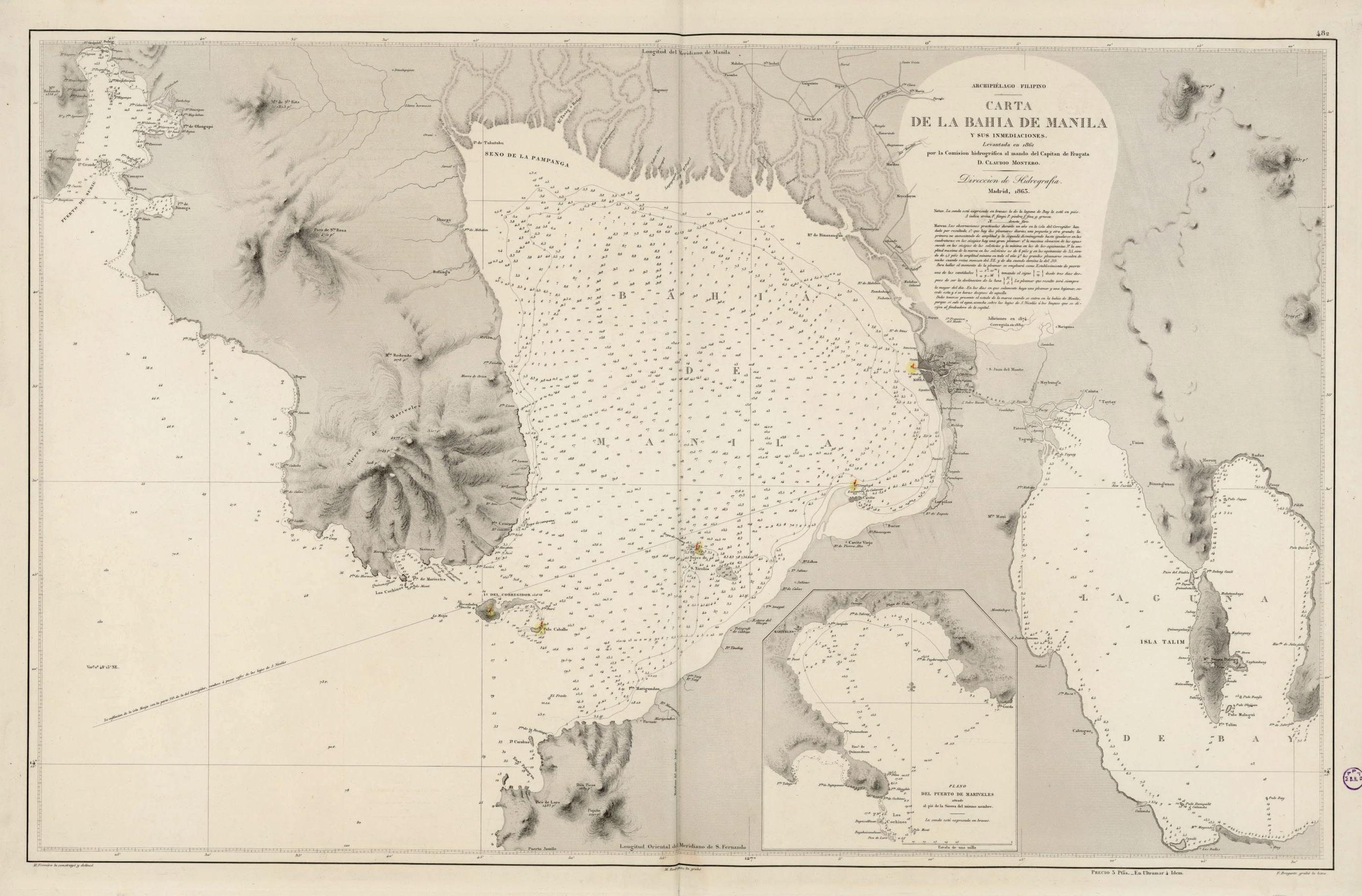
Following the AGM and dinner, retired Supreme Court Justice Antonio T. Carpio gave a talk on the Carta General (en dos hojas) del Archipiélago Filipino published by the Direccion de Hidrografía in Madrid in 1875. The map, made by the Comisión Hidrográfica de Filipinas under the leadership of navy lieutenant Claudio Montero, was approved by King Alfonso XII of Spain and was then recognised as an official map of the Philippines.
The map shows both the Bajo de Masinloc (Scarborough Shoal) and the Kalayaan Island Group as part of the Philippine archipelago, included as integral parts of Philippine territory. Consequently, it was adopted by the U.S. authorities and used in the Treaty of Washington of 1900, which corrected the errors in the 1898 Treaty of Paris and its accompanying map. The U.S. War Department subsequently issued four editions of the map (with additions), and Justice Carpio showed us the 1902 Fourth Edition which he had recently acquired and intends to donate to the National Library of the Philippines.
The second presentation was on The Comedic Maps of Frank Dorn by John Silva. BrigadierGeneral Frank ‘Pinkie’ Dorn was an iconoclast of a military man who was influenced by the pictorial mapmaker Jo Mora. While stationed in the Philippines from 1926 to 1929, he produced
Carta General (en dos hojas) del Archipiélago Filipino, U.S. War Department, Fourth Edition, 1902 (image courtesy of Ruderman Rare Maps)
comedic maps of Fort Stotsenburg in Angeles City and of Fort McKinley in Manila, both with some funny – and some less funny – vignettes of Filipino and Negrito lives from ‘insurrection to insurrecting’ to carnival shows to natives being swallowed by pythons.
The Fort McKinley map had a wider area to cover, from natives swimming at Laguna de Bay and ‘cathouses’ (brothels) in Culi-Culi to the Santa Ana cabaret further west. After he left the Philippines, Dorn drew a comedic map during his stay at Fort Sills, Oklahoma and, his most epic and best known map, a rendering of ‘Peiping’ (Peking) with the Forbidden City at the centre, a variety of markets and temples, the Legation Quarter illustrated with flags, and the Great Wall in the top-left corner. All four original maps were on display, courtesy of Albert Montilla and the Ortigas Library Foundation.
The ‘Classics of Philippine Cartography from the 16th to the 20th Centuries’ exhibition sponsored
by the National Museum of the Philippines (NMP) and PHIMCOS is ongoing at the NMP–Cebu. Despite closing for 28 days because of natural calamities, including an earthquake and typhoons in October and November, and for ten days in March for maintenance, the NMP–Cebu’s statistics record that from the exhibition’s opening on 5 July, 2025 until the end of March 2026, 182,241 visitors have seen the exhibition, an average of over 20,000 visits per month.
Originally slated to close on 31 January, 2026, the success of the exhibition has been such that at the request of the NMP the closing date has been extended by five months to 30 June, 2026.
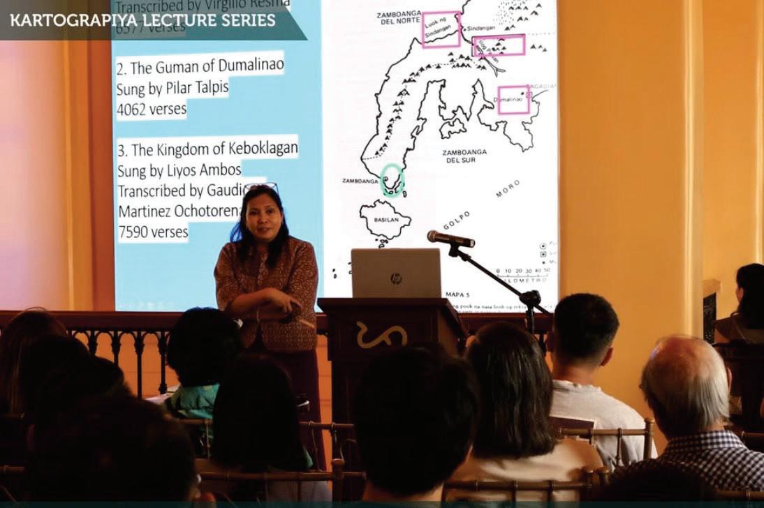
In connection with the exhibition, PHIMCOS has sponsored the ‘Kartograpiya Lecture Series’ with the following speakers:
Dr. J. Eleazar Bersales (University of San Carlos, Cebu) on ‘The Hacienda de Banilad y Talamban and the Colonial-Era Urbanization of Cebu: A Study of Archival Maps’.
Noelle Rodriguez speaking at the NMP–Cebu
Dr. Earl Jude Cleope (Silliman University) on ‘Sketching Integrity: Exploring Cartoons on Corruption in the American Colonial Period’.
Dr. Ricardo Trota Jose (PHIMCOS and University of the Philippines) on ‘Senso Chizu: Japanese World War II Maps on the Philippines’.
Dr. Jay P. Picardal (Cebu Normal University) on ‘Floras from Across the Seas: Plants Reported by the Spaniards during the Galleon Trade’.
Dr. Ambeth R. Ocampo (PHIMCOS and Ateneo de Manila University) on ‘Maps and the Emergence of the Filipino Nation’.
Dr. Felice Noelle Rodriguez (PHIMCOS and Universidad de Zamboanga) on ‘The Stories Maps Tell: Unfolding the History of Mindanao’.
PHIMCOS trustee Margarita Binamira also conducted an Education Workshop on ‘Reading Maps’. Approximately 40 junior and senior high school students from Cebu City’s Tejero Public School learned how to use a compass to tell directions; how to read maps; and how to find ‘treasures’ in the NMP-Cebu by deciphering clues in a scavenger hunt.
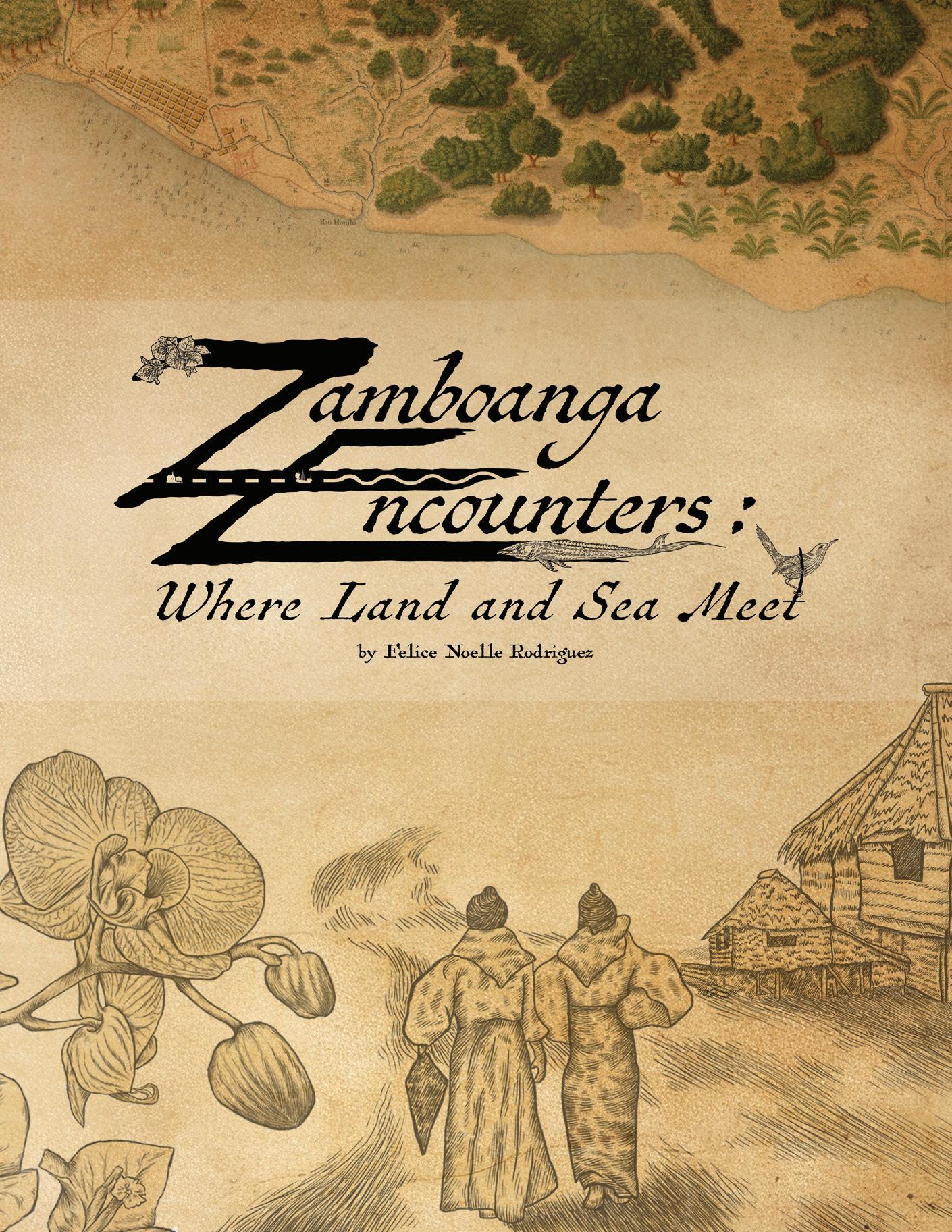
Zamboanga Encounters: Where Land and Sea Meet, the exhibition arranged and sponsored by the Universidad de Zamboanga (UZ), the National Museum of the Philippines and PHIMCOS, which opened at Fort Pilar in Zamboanga City on 28 February, 2025, has also been extended, to 30 October, 2026. Copies of the exhibition book, published by UZ, are available for purchase, with all proceeds going to the maintenance of the exhibition (see page 67
Peter Geldart has accepted an invitation to act as the National Representative for the Philippines for Imago Mundi Founded in 1934, Imago Mundi is a fully-refereed, international, interdisciplinary and scholarly journal devoted to the historical interpretation of maps and mapmaking in any part of the world. Published twice a year, the journal strives to publish evergreen and innovative research on maps, map production, materiality, original and subsequent acquisition, and uses, audiences and circulation.
The local representative will send the journal a report every April and December with news of cartographic exhibitions, conferences, symposia and workshops held in the Philippines, along with details of any cartographic books, exhibition catalogues, articles, edited volumes and monographs published in the Philippines. Events and publications sponsored by PHIMCOS will be included, but by no means exclusively, and all members are invited to submit information on any such events and publications they would like to see reported in Imago Mundi
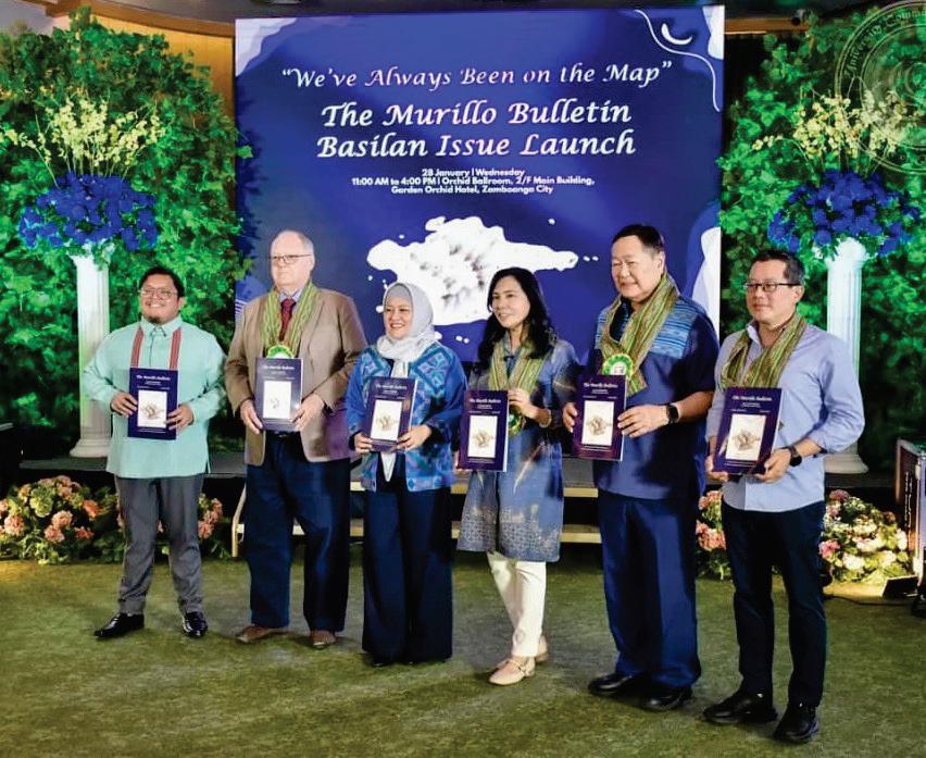
At the invitation of Isabela City Mayor Sitti Djalia Turabin-Hataman, on 28 January, 2026 Felice Noelle Rodriguez and Peter Geldart joined the official launch of The Murillo Bulletin: Basilan Special Issue. Headlined ‘We’ve Always Been on the Map’, the launch was held at the Orchid Ballroom of the Garden Orchid Hotel in Zamboanga City. The event was well attended by Basilan councilors, other government and education officials from Isabela City, and representatives from Ateneo de Zamboanga University, Universidad de Zamboanga and Western Mindanao State University.
After lunch, the opening formalities and Welcome Remarks by Mayor Dadah, retired Justice Antonio T. Carpio gave his talk on ‘The Carta General del Archipiélago Filipino’. This was followed by a performance of the Sama Igal Dance by Jojo Laki, and then by the PHIMCOS PowerPoint presentation on ‘The History and Mapping of Basilan and the Basilan Channel’. The afternoon concluded with a message from Sakiran Hajan, a representative of the Basilan elders, closing remarks by Ahmed Djaliv Amin Hataman, and the distribution of copies of the Basilan Special Issue to all attendees.
The next morning we visited Isabela, where we were warmly greeted at the Basilan National High School by over 100 school principals and senior history teachers from the Schools Division of Isabela City led by SDS Ma. Laarni Villanueva, OIC Principal Arnel Hajan and EPS Dr. Elsa Usman. Again, after opening formalities and speeches, both the PHIMCOS presentation and copies of the issue were delivered and received with
enthusiasm and a spirited ‘thank you’. We then adjourned to the Basilan Provincial Government Center in the new Basilan Capitol building to be welcomed by Provincial Administrator Manny Muarip and other provincial department heads. They too much appreciated receiving copies of our journal.
Apart from the generosity of Mayor Dadah and her family in sponsoring The Murillo Bulletin: Basilan Special Issue, arranging the launch events in both Zamboanga and Basilan, and hosting us overnight in Isabela, we were surprised and delighted by the overwhelmingly positive feedback we received from our audiences.
Not only were our presentations and copies of the issue met with enthusiasm, but we also received detailed comments and some corrections on the contents (see below). We believe this reinforces not only the Mayor’s efforts to promote and preserve the history of her city and the island, but also sends a positive message that our Society’s commitment to cartographic education across the Philippines is well appreciated and valued.
Page 7: the caption to the photograph should read ‘Marian Pastor Roces and me with a traditional Yakan textile weaver’, as the textile shown is Yakan not Tausug.
Page 15: we state that the name Basilan may have been derived from the island being the source of basih-balan, the Tausug word for magnetic iron. Earl Francis C. Pasilan has clarified that bessi and lan are the Yakan words for ‘iron’ and ‘way or path’ respectively, hence Basilan being the ‘way to the iron’ in the igneous rocks that the Yakan used to smith their pira (knives) and barung (swords).
Page 16: Pasangen, the old name for Isabela – also recorded as Pasangan, Pasanhan, Pasañhan, Passan and Pasanhar – is the Yakan term for ‘point of entry’ or ‘a place where people meet and exchange their products’.
Launching The Murillo Bulletin: Basilan Special Issue at the Garden Orchid Hotel, Zamboanga
Launching The Murillo Bulletin: Basilan Special Issue at the Basilan National High School, Isabela City
The Murillo Bulletin: Basilan Special Issue – Addenda et Corrigenda
Page 16: the caption to the photograph should read ‘A Tausug datu with his retinue c.1910’ as the men can be identified as Tausug, not Yakan, from their dress.
Page 37: most of the villages and rancherias listed by Julián González Parrado in his 1893 book Memoria Acerca de Mindanao still exist today among the 210 barangays of Basilan, but some with different spellings; for example, ‘Bugelucbon’ is Buhelubung, ‘Buje Zapi’ is Busay, ‘Candus’ is Candiis, ‘Ee on’ is Lebon, ‘Jali-jali’ is Lahi-lahi, ‘Panadacan is Panandacan’, ‘Punducan’ is Puntukan, ‘ Tamblan’ is Tablas, and ‘ Tidu-tipo’ is Tipo-tipo
Page 43: life in Basilan during World War II is the subject of Somewhere the Sun Is Shining: Look for the Silver Lining, a book by Alexis and Norma Strong in which Alexis (the youngest son of James Walter Strong) describes growing up on his family’s rubber plantation on Basilan during the Japanese occupation.
Page 44: in 2024 Basilan Province was formally declared free of the terrorist Abu Sayyaf Group, as marked by the Pillar of Peace which dominates the foyer of the new Basilan Provincial Capitol building. The pillar is made from decommissioned weapons welded together, and is topped by a pair of open hands holding a white dove with spread wings and an olive branch in its beak, symbolising the triumph of peace over violence in the Province
WATTIS FINE ART Est. 1988 Specialist Antique & Art Dealers
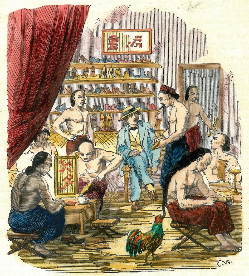
‘Shoemaker's Shop in Manilla’ by Charles Wirgman The Illustrated London News, 2 January, 1858 www.wattis.com.hk
Antique maps, prints, photographs, postcards, paintings & books
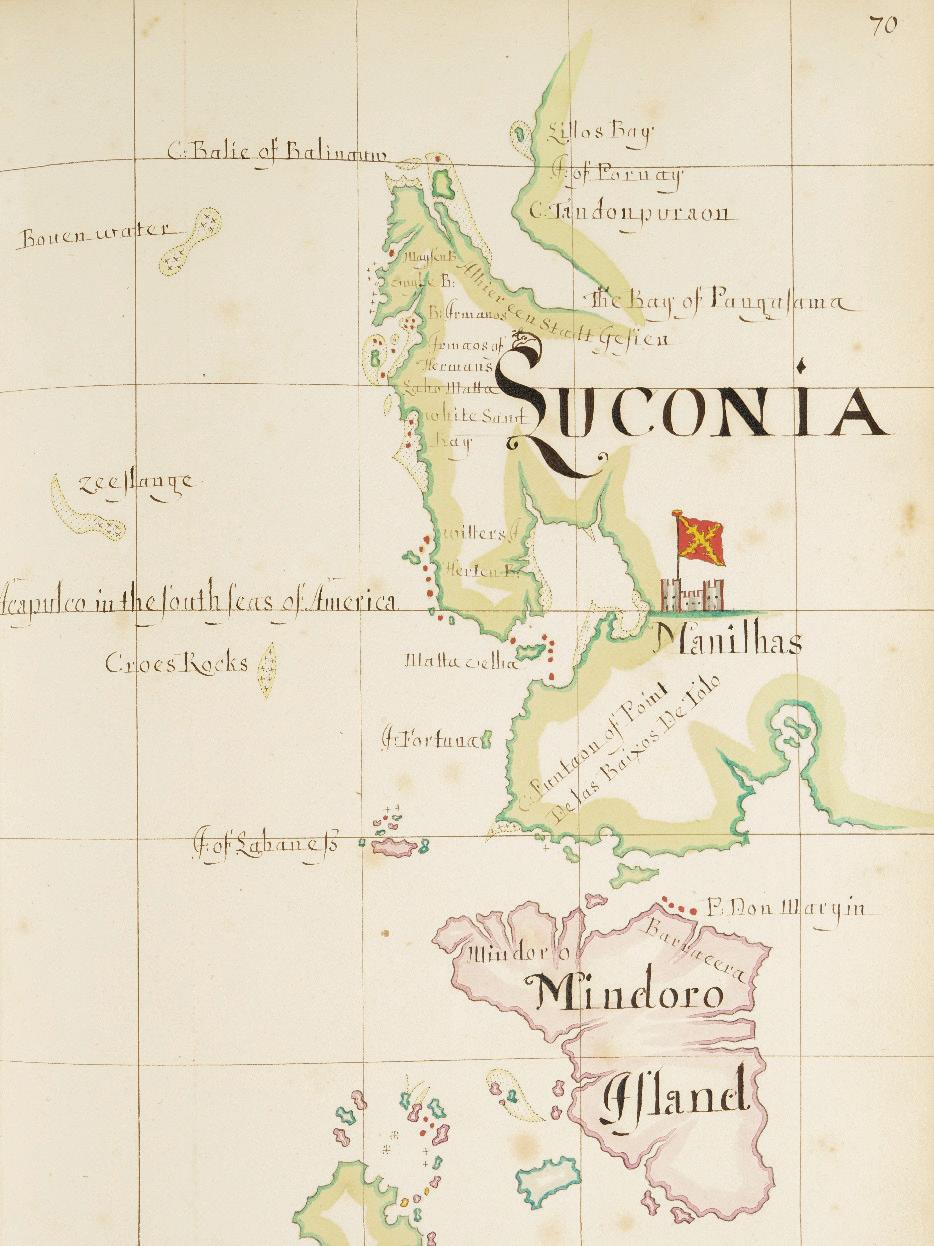
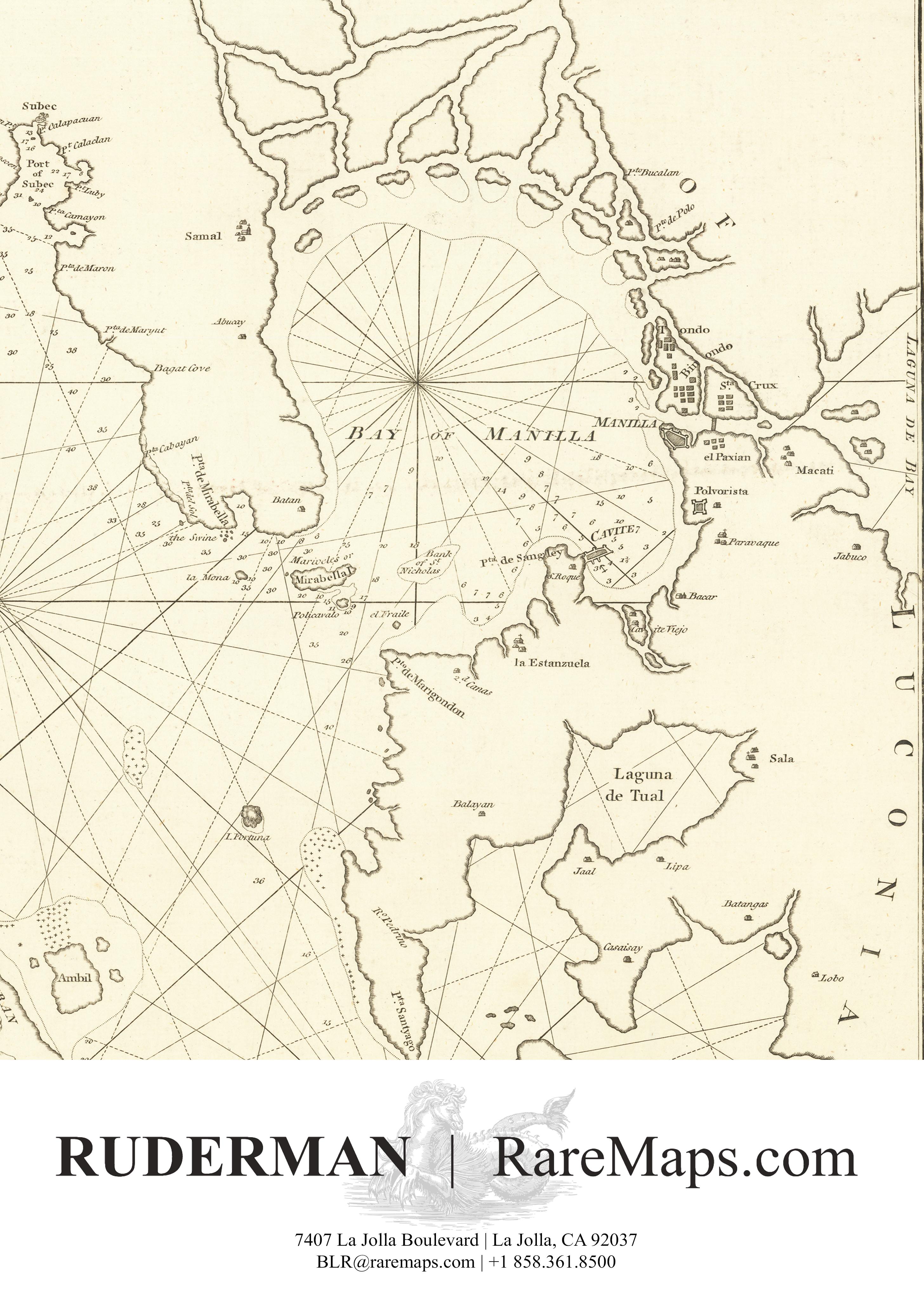
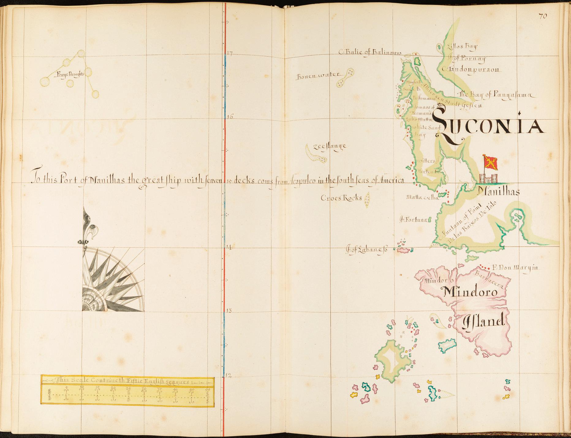
OUR COVER shows details of the islands of Luconia and Mindoro from a manuscript atlas by William Hacke in the British Library. Hacke (c.1655-1708) was one of the most prolific chartmakers of his time. Born in Winchester, he was apprenticed to the chartmaker Andrew Welch for nine years and flourished as a chartmaker until c.1702, during which time (according to the Oxford Dictionary of National Biography) he produced over 300 manuscript charts
Hacke (aka Hack) and Welch (along with James Atkinson, John Burston, John Colson, Nicholas Comberford, John Daniell, William Fisher, John Friend, Joel Gascoyne, John Kempthorn, Martin Llewellyn, John Seller, Gabriel Tatton, John Thornton et al ) were members of the so-called Thames School of chartmakers who were active in the 17th and early-18th centuries and plied their
trade in the streets along the waterfront, mostly on the north bank of the Thames, east of the Tower of London, copying and embellishing Portuguese, Spanish and Dutch charts
Following the Third Anglo-Dutch War (1672-74), in the 1680s the English buccaneer captain Bartholomew Sharp conducted raids on Spanish ships in the Caribbean and (having crossed the Isthmus of Panama on foot) along the Pacific coast of South America, during which he seized a Spanish derrotero (book of sea charts and sailing directions) from the ship El Santo Rosario The stolen derrotero was taken back to England and gifted to King Charles II. Hacke then made copies of the charts, which he published as an atlas of 182 charts titled A Description of all the Ports Bays Roads Harbours Rivers Islands Sands Shoalds (sic) Rocks & Dangers in the South Seas of America …
Luconia and Mindoro from a manuscript atlas c.1700 by William Hacke (image courtesy of the British Library Collection ref. Maps 7.Tab.125
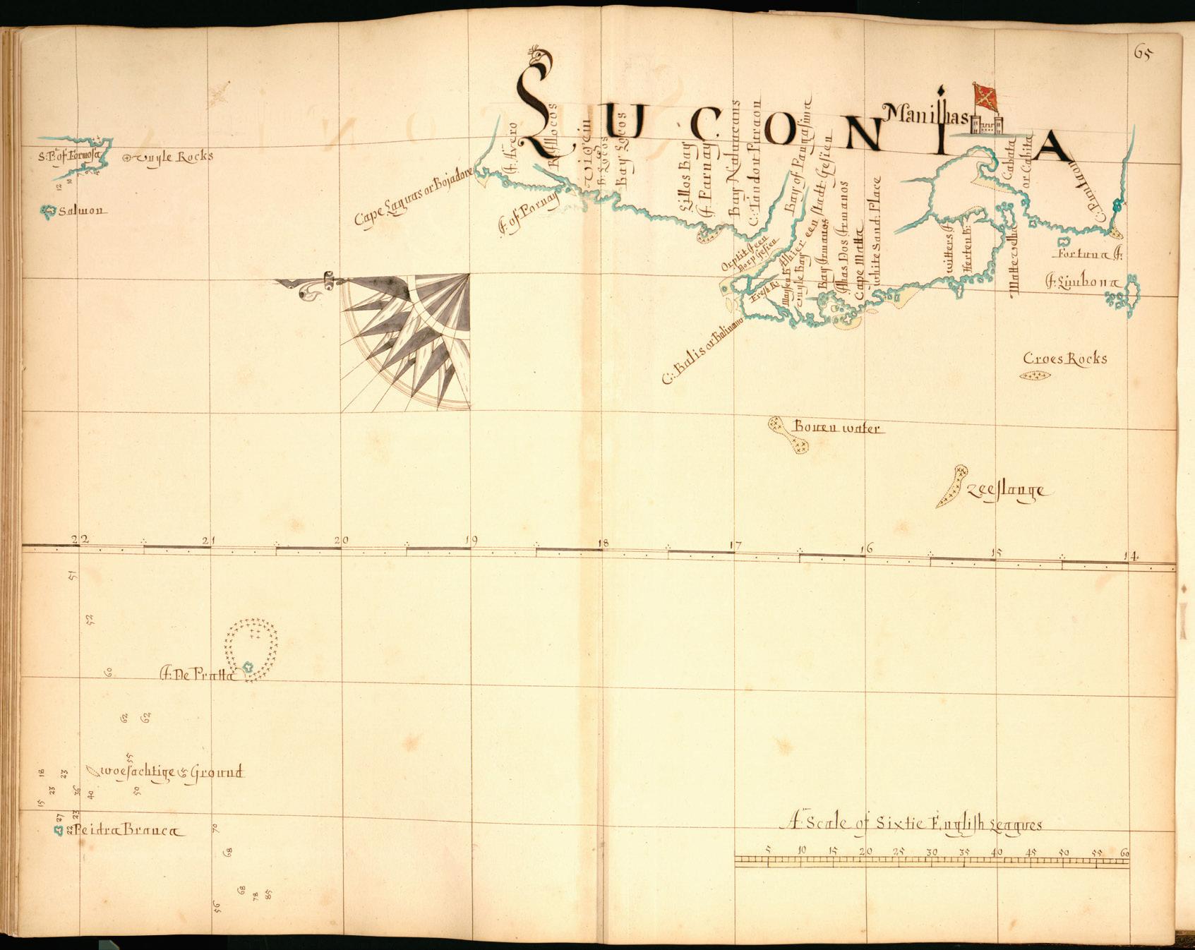
Luconia from a manuscript atlas c.1690s by William Hacke (image courtesy of the Library of Congress ref. G2201.P5 H3 1690)
In 1699 Hacke edited A Collection of Original Voyages (published by James Knapton), including Sharp's journal, in which he was described as ‘Capt. William Hacke’ although there is no evidence that he ever went to sea.
Hacke also produced atlases of the coastlines of Africa and Asia, and a total of 14 of these atlases, which were known as ‘South Sea Waggoners’, are today held in libraries in England and the U.S. The atlas in the British Library, from which our cover image comes, was formerly owned by King George III. It contains 85 charts of the coasts and islands from southern Africa to southeast Asia and Japan. The dedication reads (sic): “To The Right Hon.able John Lord Sommers Baron of Evesham Chancellour of England &c; This Manuscript describeing the coasts of India &c. is most humbly dedicated and presented by my Lord may it please yr. Ld.shp yr. Lordships faithfull & most Obedient servant William Hacke.”
The chart shows toponyms down the coast of Luzon, displayed in the style of a portolan, from ‘Lillos Bay’ and ‘C : Balie of Balinano’ southwards
to ‘C.: Puntaon of Point De las Baixos De Tolo’, the island of Mindoro, and unnamed islands further south. ‘Manilhas’ is identified by a pictogram of a castle flying the Spanish flag with a yellow saw-toothed Cross of Burgundy on a red ground. A note reads ‘To this Port of Manilhas the great ship with seaven (sic) decks coms (sic) from Acapulco in the South Seas of America’. Along the south coast of the Gulf of Lingayen (named as ‘The Bay of Pangasama’) another note reads ‘Alhier een Stadt Gesien’ [a city is seen here], indicating that Hacke copied a Dutch chart, most probably from the Vereenigde OostIndische Compagnie (VOC).
The chart of Luconia in the Hacke atlas held by the Library of Congress is orientated to the east It shows the south point of Formosa and the west coast of Luzon, with toponyms from ‘Cape Laguas or Bojadore’ and ‘Vigein’ to the islands of Fortuna and Limbona. Otherwise the chart is quite similar to the one in the British Library. Again, the note along the Gulf of Lingayen as well as the presence of ‘woesachtige [dangerous] Ground’ west of the ‘I de Pratta’ indicate a VOC origin for the chart.
Maps of the Philippines in the Royal Geographical Society
by Peter Geldart
FOUNDED ON 16 July, 1830 under the name Geographical Society of London and renamed the Royal Geographical Society (RGS) under the patronage of King William IV, the Society was granted its royal charter by Queen Victoria in 1859. Originally formed for the advancement of geographical science, the RGS initially focused more on exploration, with the Institute of British Geographers (IBG), formed in 1933, leading a more systematic study of geography. The two societies merged in 1995.
The RGS has always been among the most active of the learned societies. Now the largest geographical society in Europe and one of the largest in the world, the RGS with IBG operates at a regional, national and international scale to support research, education and training to promote a wider public understanding and enjoyment of geography. The Society’s collections of books, documents, atlases, maps, periodicals, photographs, paintings and cultural artefacts comprise over two million items. To quote the Society’s website:
We hold one of the largest private map collections in the world and it is continuously increasing in size. It includes one million sheets of maps and charts, 3,000 atlases, 40 globes (as gores or mounted on stands) and 1,000 gazetteers. … The map collection has a focus on scientifically surveyed maps and charts from official agencies at home and abroad. It also includes original manuscript mapping.
Given its origins, the Society’s collection is dominated by maps and other items from exploratory expeditions to Africa, Southeast Asia and the polar regions, or acquired from former British colonies, dominions and Commonwealth countries. The online catalogue also lists 154 maps of the Philippines, so when I visited London in June 2025 for the annual map fair I took the opportunity to book a visit to the library Around half of the maps of the Philippines listed in the catalogue date from World War II or later, so I requested to see 24 of the earlier ones, especially some that I did not recognise
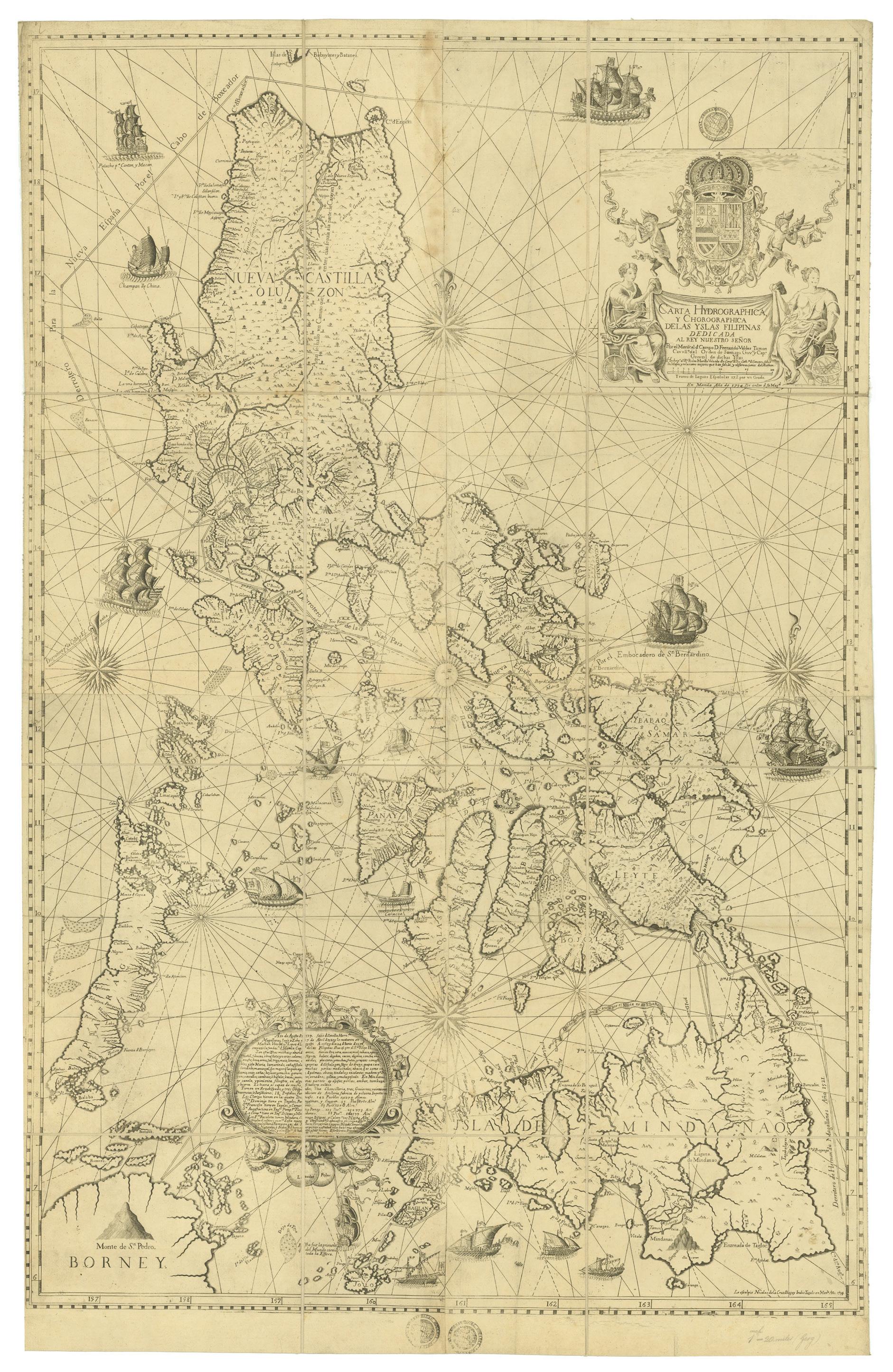
As I had hoped, the first one I examined, which is catalogued as Carta Hydrographica y Chorographica delas Yslas Filipinas / Por el D. Fernando Valdes Tamon, turned out to be an example of the magnificent 1734 map by the Jesuit Fr. Pedro Murillo Velarde. This brought to 17 the total number of original copies of this map of which I am aware, held in private and institutional collections in the Philippines, England, continental Europe and the United States.
Unfortunately the map is missing the side panels which show detailed engravings of different ethnic groups living in the Philippines, rural scenes and inset maps. It has been sectioned into 12 panels, laid on linen and folded. Its provenance is not recorded, but from the stamps added to the bottom of the map it appears to have been acquired by the RGS in the 19th century.
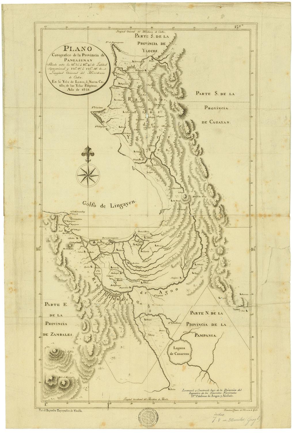
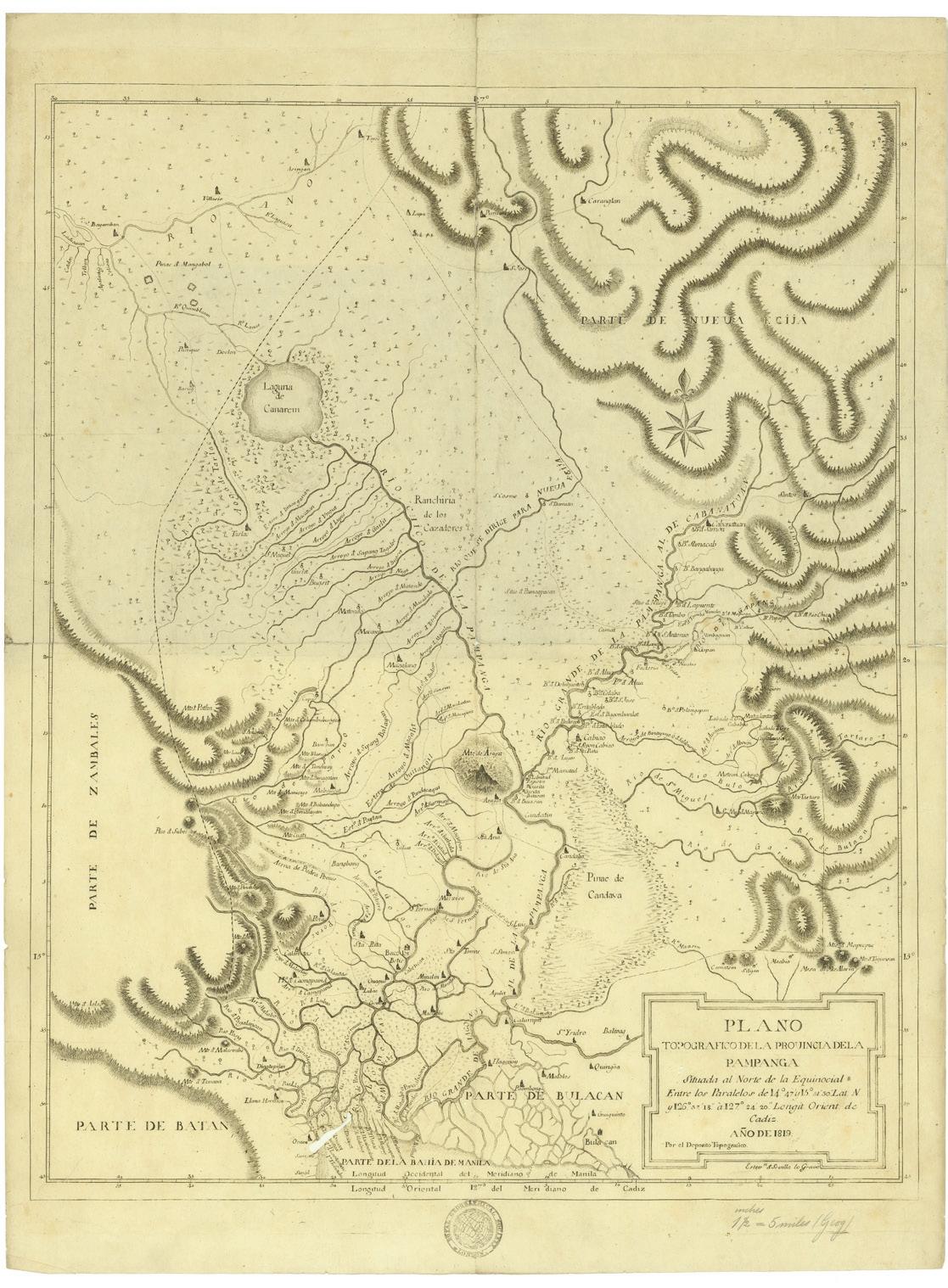
My next ‘find’ was three maps by Ildefonso de Aragón y Abollado, who founded the Depósito Topografico mapping agency in Manila in 1819. Its first publication was the Descripción Geográfica y Topográfica de la Ysla de Luzon o Nueva Castilla, a work published from 1819 to 1821 that included maps of 16 provinces in Luzon, the first individual maps of provinces in the Philippines. These maps are rare and difficult to find even as digital images, so I was delighted to be able to examine three of them: Plano Topografico dela Provincia dela Pampanga, dated 1819; Plano Corografico de la Provincia de Pangasinan, dated 1821; and Plano Esferico de las Provincias del Norte y Sur de Ylocos, also dated 1821.
Carta Hydrographica y Chorographica delas Yslas Filipinas by Fr. Pedro Murillo Velarde, Manila, 1734 (RGS Control No. 542030 © Royal Geographical Society (with IBG))
Spanish charts in the collection include the Carta Esférica de la Bahía de Manila published by the Direccion Hidrografica in Madrid in 1807 from the surveys made in 1792 by the corvettes Descubierta and Atrevida on the expedition led by Alessandro Malaspina The chart of Manila Bay is accompanied on the same sheet by three smaller ones: the Plano del Puerto de Maribeles; the Plano del Puerto de Cavite; and the Plano del Puerto de S. Jacinto Another chart from the same expedition shows the Plano del Puerto de Palapa and the Plano del Puerto de Sorsogon
The Malaspina Expedition’s cartographer, Felipe Bauzá y Cañas, also produced a Carta General del Archipiélgo De Filipinas that was published in Madrid in 1808 and then copied by Aaron Arrowsmith in London in 1812. His Chart of the Philippine Islands, from the Spanish Chart 1808 /
The Adjacent Islands are added from the latest Surveys was published in at least six editions; the two copies of this map (one of which has been sectioned) held by the RGS are the edition published by Aaron’s son Samuel Arrowsmith in 1832.
Other Spanish maps in the collection include the impressive four-sheet Carta Itineraria de la Isla de Luzon by Anselmo Olleros, lithographed by the Depósito de la Guerra in Madrid in 1882. Its provenance is indicated by a stamp on the map reading ‘Intelligence Div. W.O. Map Room 28 Jan. 1901’. The RGS’s copy of the impressive wall map Plano Topográfico de la Isla de Cebú by Enrique Abella y Casariego, dated 1884, engraved by J. Mendez and printed in Madrid by the lithographic printing firm of Nicolás González, has been laid on linen and needs restoration
Plano Corografico de la Provincia de Pangasinan (left) and Plano Topografico dela Provincia dela Pampanga (right) by Ildefonso de Aragón y Abollado, Depósito Topografico, Manila, 1821 and 1819 respectively (RGS Control Nos. 542124 and 524118 © Royal Geographical Society (with IBG))
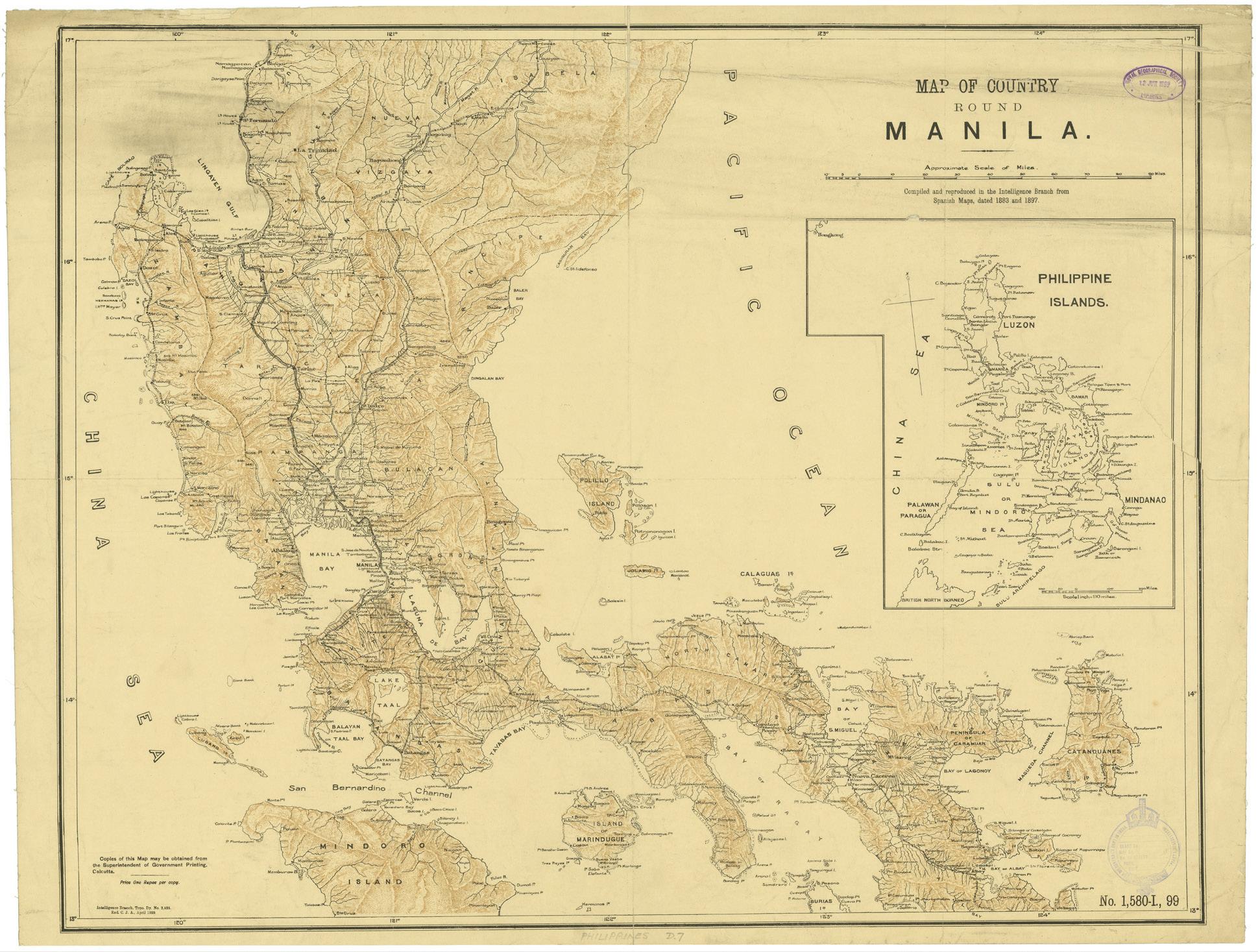
Map of Country Round Manila / Compiled and reproduced in the Intelligence Branch from Spanish Maps, dated 1883 and 1897, Calcutta, 189 (RGS Control No. 542120 © Royal Geographical Society (with IBG))
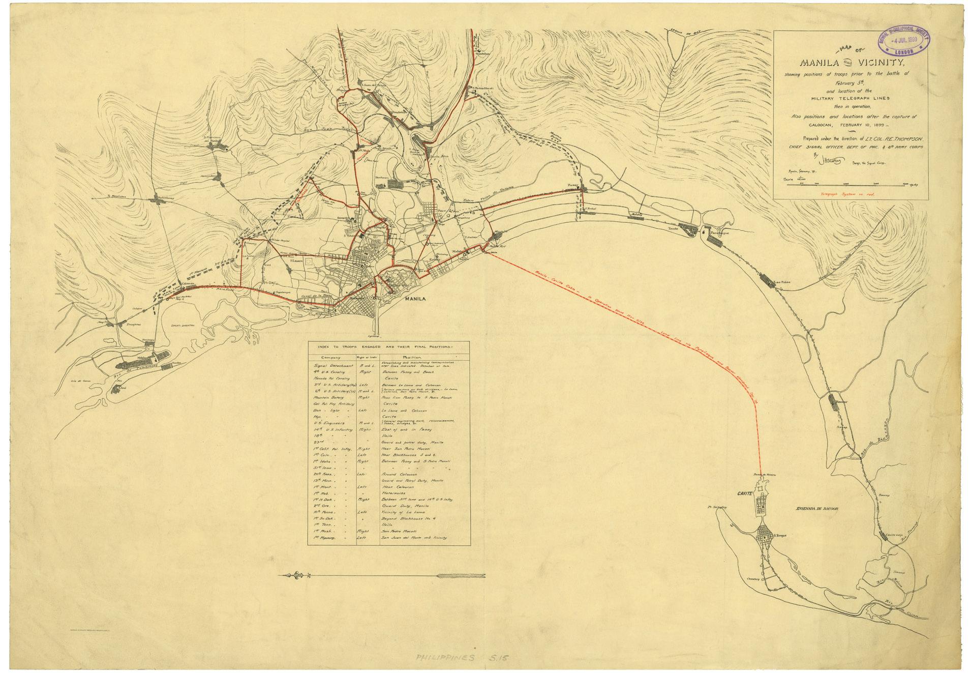
Map of Manila and Vicinity, showing positions of troops prior to the battle of February 5th, and location of Military Telegraph Lines then in operation (RGS Control No. 542185 © Royal Geographical Society (with IBG))
During the 18 years Enrique d’Almonte y Muriel spent with the Inspección General de Minas de Filipinas he produced a series of detailed topographical maps of the Philippines. Three of these are held in the RGS: ‘topographical sketches’ of the Island of Negros and the District of Samar, and the two-sheet Distrito de Leyte Bosquejo Topográfico Dated 1898, a rubber stamp indicates that the latter map was acquired by the RGS on 2 December, 1899.
For me the most interesting map was one that I had not seen before, and which is apparently unrecorded anywhere else. The Map of Country Round Manila / Compiled and reproduced in the Intelligence Branch from Spanish Maps, dated 1883 and 1897 is dated April 1899 and was produced in Calcutta with the references ‘Intelligence Branch, Topo. Dy. No. 2,528’ and ‘No. 1,580-I, 99’ It states that ‘Copies of this Map may be obtained from the Superintendent of Government Printing, Calcutta. / Price One Rupee per copy.’
Measuring 63.5 cm. x 81 cm., the map covers most of southern Luzon from Isabela to the Bay of Albay, including adjacent islands, and shows the topography, roads, railways, telegraph lines and lighthouses. An inset map of the Philippine Islands extends from Hong Kong to British North Borneo. The map must have been sent to London as soon as it was printed as a rubber stamp records that it was received by the RGS on 12 June, 1899
Maps from the early American period in the Philippines are well represented. The Carta General del Archipiélago Filipino is not the original printed by Chofré y Comp. in Manila in 1897 – of which only a single example is known to have survived today – but the still uncommon quarter-sized edition (110 cm x 81 cm.) which was ‘reproduced under the Direction of Brigadier General A.W. Greely, Chief Signal Officer, U.S. Army, for Use of the Signal Corps, U.S.A.’ in 1899.
Another map I had not seen before (although a digitised photocopy is available in the Library of Congress) was the Map of Manila and Vicinity, showing positions of troops prior to the battle of February 5th, and location of Military Telegraph Lines then in operation / Also positions and locations after the capture of Caloocan, February 10, 1899 / Prepared under the direction of Lt. Col.
R.E. Thompson, Chief Signal Officer, Dept. of Pac & 8th Army Corps By J.H. Warking Sergt. Vol. Signal Corps / Manila, February, ’99 The Telegraph System is shown in red, including the ‘Manila ‒ Cavite Cable ‒ In Operation since Nov. 8/98’, and abandoned land lines.
I was also delighted to view the largest printed map of the Philippines I have seen. The Map of the Philippine Islands Compiled from the Latest Official Data in the Military Information Division, Adjutant General’s Office, War Department, Washington, U.S.A. 1903 was published on four sheets, each measuring 124 cm. x 82 cm. As well as a wealth of toponyms and topographical detail, the map has an inset map of Manila dated 1902. Drawn by C.H. Stone, lettered by C.H. Ourand, and lithographed by Julius Bien & Co. in New York, the map was obtained by the RGS on 20 November, 1903.
Another large map, on two sheets (measuring 180 cm x 126 cm when joined), is the Post Route Map of Philippine Islands showing post offices in operation on the 1st of September, 1905. / Published by order of Postmaster General Geo. B. Cortelyou under the direction of A. von Haake, Topographer P.O. Dept. In the title cartouche the map carries the seal of the ‘Post Office Department United States of America’ As well as Post Offices, County-seat Post Offices and Money Order Offices, the map shows railroads and provincial boundaries (with an index of the provinces), and carries an ‘Explanation of Mail Service’ There are inset maps of the Batan and Babuyan Islands, Manila Bay, Balabac Island, the Jolo Archipelago and the Sarangani Channel
A large number of maps of the Philippines in the RGS library date from the American period, including maps of the provinces made by the U.S. Coast and Geodetic Survey in the 1920s and 1930s, many of the maps from the 1939 Census Atlas of the Philippines, and close to 40 maps produced by the U.S. Army during WWII. There are also more recent road and tourist maps.
A visit to the RGS library at 1 Kensington Gore, SW7 2AR is to be recommended for any PHIMCOS members when in London. At the RGSIBG I thank Dr. Katherine Parker, Cartographic Collections Manager, for arranging my visit, and Joy Wheeler, Assistant Librarian: Photographs and Artworks, for providing the images.
The First Cavalry’s ‘Flying Column’ Dash to Manila
Our family’s experience of the days of the liberation by Alberto Montilla
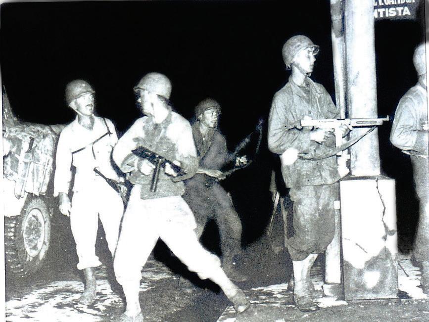
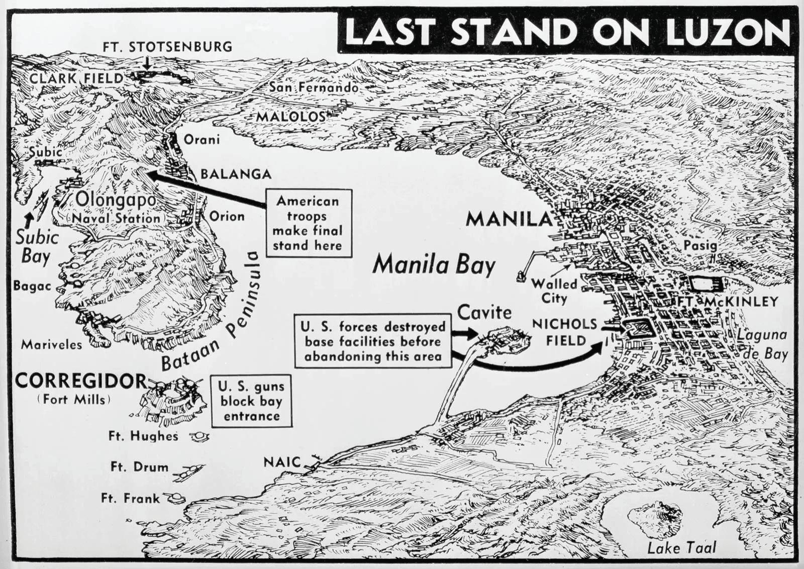
American forces landed in Lingayen Gulf on January 9, 1945 and, having established a beachhead, General Douglas MacArthur decided to make a quick dash for the capital The Battle of Manila began as the U.S. Army’s 1st Cavalry Division rushed into Manila from the north on the evening of February 3, 1945.
Much has been written about the battle, including two books reviewed in The Murillo
Bulletin ‒ Rampage: MacArthur, Yamashita, and the Battle of Manila by James M. Scott and The Battle of Manila: Poisoned Victory in the Pacific War by Nicholas Evan Sarantakes. However, these accounts largely focus on the fighting to the south of the Pasig River (including Malate, Ermita and Intramuros). Hardly anyone has written about the northern part of the conflict. Consequently, I want to record my family’s experience of the liberation north of the Pasig
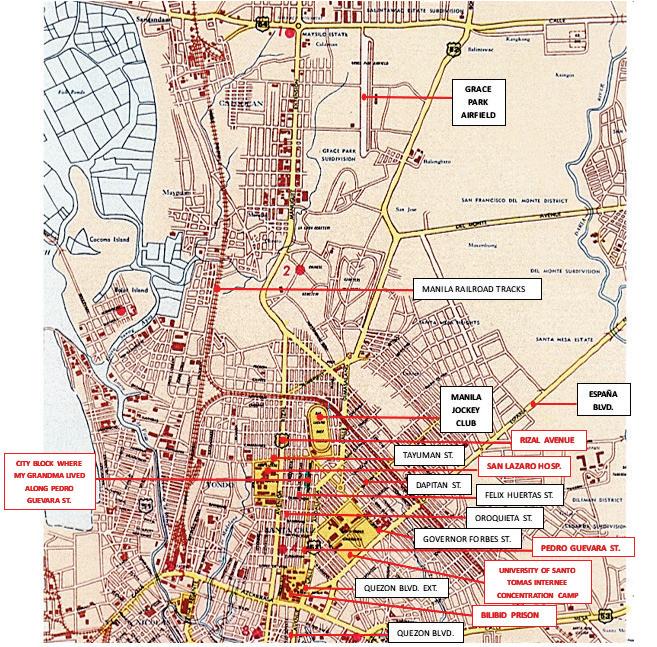
Map of northern Manila in 1945
Wings cigarettes aircraft recognition cards, from my brother’s collection
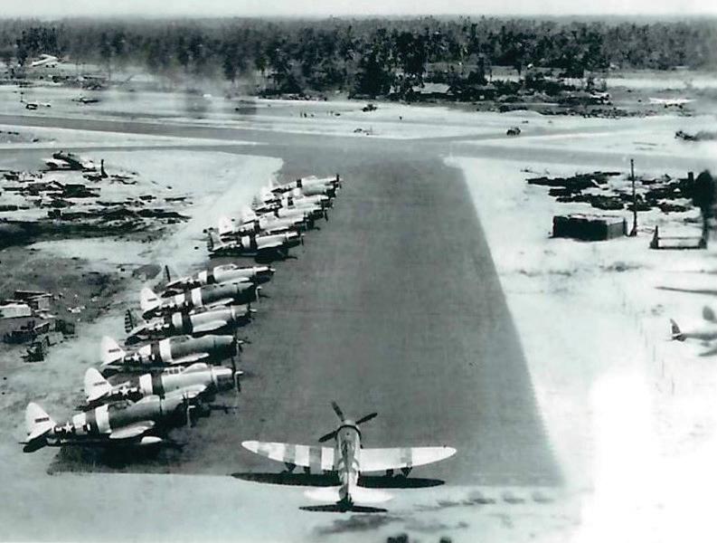
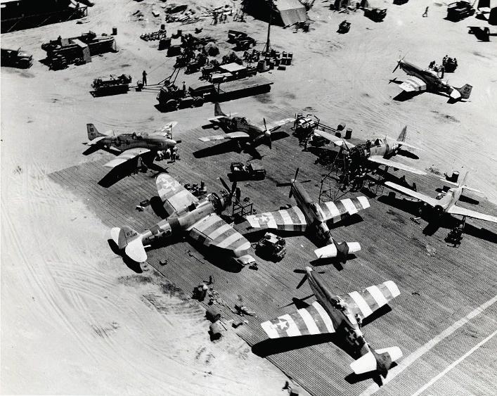
Republic P-47 Thunderbolt fighters with ‘invasion stripes’ at Lingayen Airfield, 1945
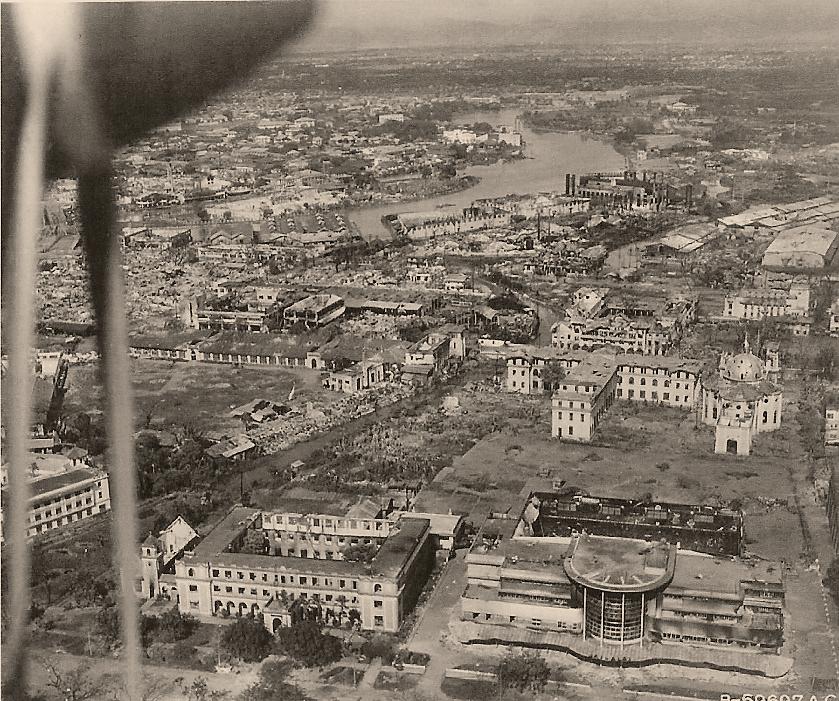
What we experienced was at an altitude much lower than this photo from a Reconnaissance P-38 aircraft over Taft Avenue in 1945. Recognizable buildings are the Santa Isabel College and the Jai Alai Building, with Adamson University and St. Paul’s Church behind.
P-51 Mustangs and a P-47 Thunderbolt aircraft with ‘invasion stripes’ at Lingayen Airfield, 1945
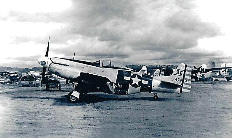
Later in the war and after the liberation we recognized this Mustang P-51 fighter with ‘invasion stripes’; photo taken at Clark Field, 1945
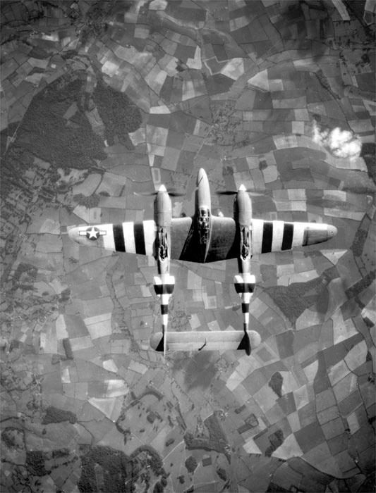
P-38 Lightning Fighter aircraft used for photo reconnaissance (F-5) with ‘invasion stripes’
During the wee hours of the evening, about three days before the entry of the Americans, we could hear some faint occasional explosions from far away, and the rattling of machine gunfire. These noises could not be heard during the day because of the bustling of daily activities. But then, one day in the early afternoon, we heard the loud drone of airplanes.
My brother Luis and I ran to the window and saw three American airplanes flying very, very low in a V formation. My brother had been collecting photographs and magazines of different types of aircraft – American, British and European – since before the war started, yet two of these planes were unknown to him. The third was a Lightning P-38 fighter called ‘double body’ by my friends in the neighborhood. These airplanes were painted in unusual silver and had black stripes on their
wings and fuselage. The formation was flying from west to east and back from east to west. We were surprised that there was absolutely no antiaircraft fire from the Japanese!
Some years after the liberation we found out that these black stripes, called ‘invasion stripes’, were first used by the U.S. Army Air Force and the British Royal Air Force at the Normandy landings in France on June 6, 1944. At the time we could not tell what the objective of these airplanes was, but after the liberation we figured that one of the aircraft (possibly the P-38/L-5) may have been on a photo reconnaissance mission of the area in preparation for the army’s eventual entry into Manila some days later.
Around mid-afternoon on February 3 we saw two Japanese vehicles – a truck full of armed soldiers
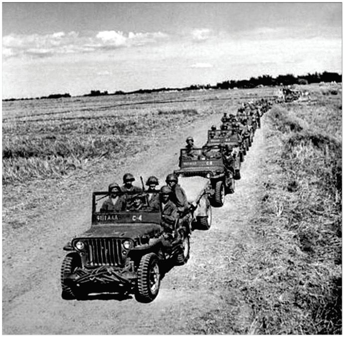
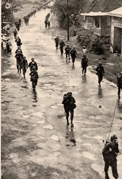
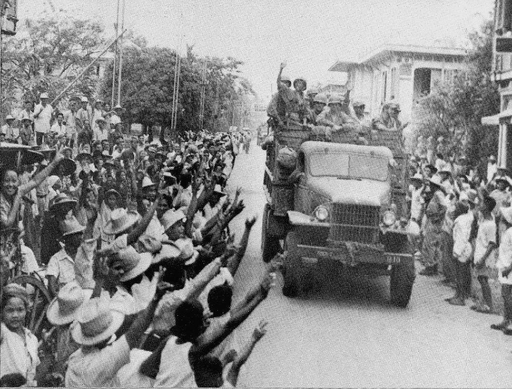
The ‘Flying Column’ in the dash to Manila
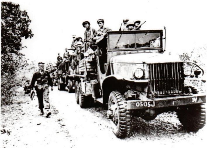
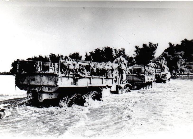
The column fording a river on its way to Manila
A 1st Cavalry infantry unit approaching northern Manila
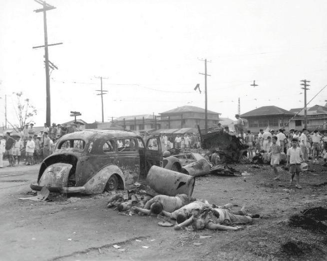
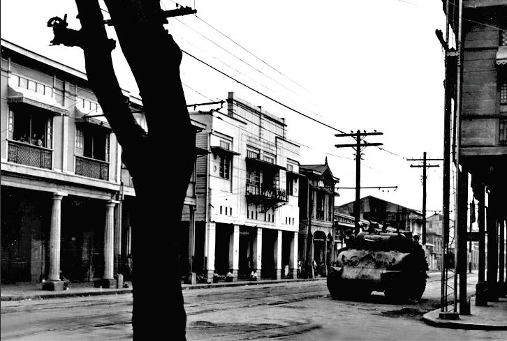
Enemy casualties as a result of a firefight upon the A Sherman tank rumbling along Rizal Avenue entry of the Americans into northern Manila along the intersection of Rizal Avenue and the railroad tracks of the Manila Railroad Co.
and a pick-up van with a machine gun mounted behind the driver’s seat with a gunner manning it – passing along Pedro Guevara Street on their way northwards, possibly to the Blumentritt area or to the Grace Park Airfield in Caloocan further north.
Then later that afternoon we heard gunfire from afar and, around 5:30-6:00 p.m., loud rumbling sounds coming from the western side of my grandmother’s house, possibly from Rizal Avenue, the main street. It sounded like vehicles and tanks traveling at some speed, and then there was silence. Sometime later our electricity was cut off.
During our early dinner that evening, because of the uncertainty of the situation my father instructed all of us to sleep on the ground floor of the house, behind the concrete staircase, for protection just in case something would happen. At about midnight we heard gun fire coming from one end of our street close to the Manila Jockey Club at the northern tip of Pedro Guevara and Governor Forbes Streets. There was a response from the other end of the street and this went on for about an hour, followed by silence until morning.
Early the next morning, February 4, there was talk among our neighbors that the Americans had arrived and, in a firefight the night before, an American soldier and two Filipino guerilla guides had been killed somewhere in the neighborhood of Felix Huertas Street. Since the situation
seemed to have quieted down, my father Jose, my brother Luis (16), my sister Nena (15), my grandmother’s adopted boy Filemon (11 or 12) and I (9) went to see the results of the previous night’s ambush. Filemon was the son of my grandmother’s widower cook in Calauag, Tayabas, Quezon Province
We found a tall, well-built, red-headed American soldier, his helmet and rifle missing, lying face down in the middle of the street with his arms outstretched, and with a bullet wound in his
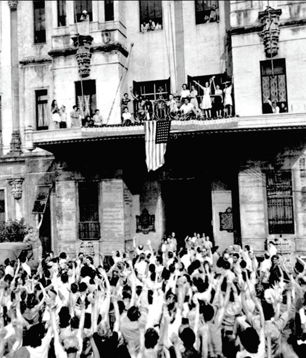
Salute to the American Flag hung from the main entrance building of the University of Santo Tomas
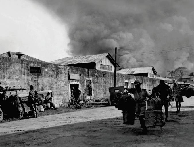
Fire across Azcarraga Street as seen from Oroquieta Street; the western wall of the Bilibid Prison is clearly visible
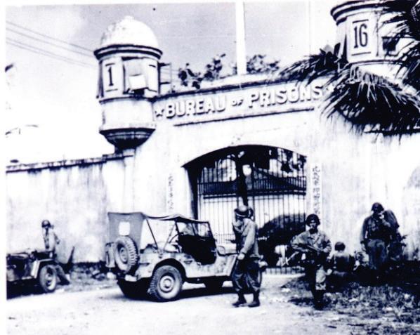
The ‘Parade’: American troops on 6x6 trucks on their way to the Bilibid Prison
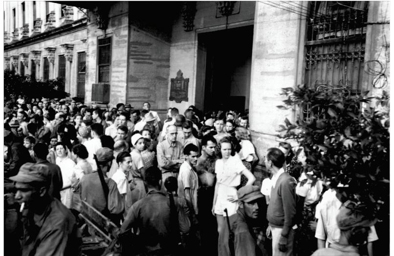
UST internees just liberated
General William C. Chase upon entry into downtown Manila on his way to liberate allied prisoners and internees in the Bilibid Prison and the University of Santo Tomas internee concentration camp
Main entrance to the Bilibid Prison on Azcarraga Street (now called Claro M. Recto Avenue)
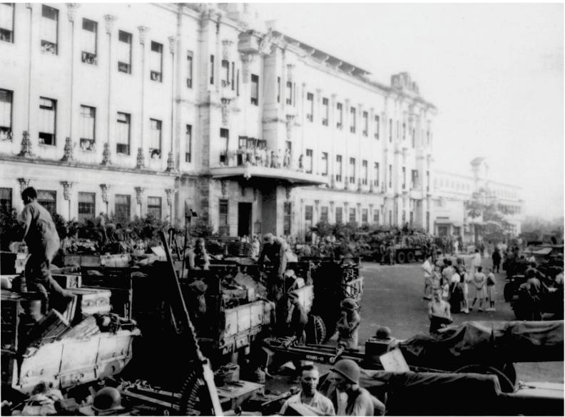
1st Cavalry vehicles and equipment parked almost in front of the UST main building
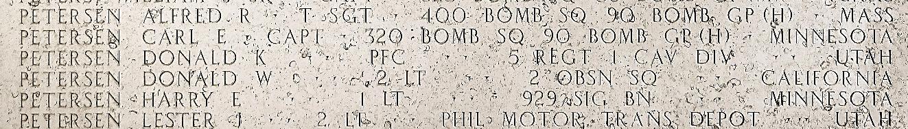
Donald K. Petersen’s name is listed at the Manila American Cemetery and Memorial chest that penetrated all the way to his back. My sister Nena looked at his dog tag and noted his name – Donald Petersen. Two shoeless guerilla scouts were also gunned down a few meters away next to a garage door, one with a backpack facing up and, some meters away, the second scout lying on his side.
That afternoon the American troops started entering the city in force in 6-ton 6x6 trucks Men were going towards the Bilibid Prison, possibly to pick up the allied prisoners and internees they had just liberated the night before. It looked like a parade! The local onlookers chanted Victory Joe! Victory Joe! Victory Joe! to the moving trucks and troops riding in them, heading for the prison. We also heard that the night before the Americans had liberated the Allied internees at the University of Santo Tomas (UST) compound.
When my brother heard about this spectacle, he sought permission and went to see what was going on. Without anyone in the house knowing, Filemon followed him from some distance. As my brother was watching the ‘parade’ of trucks and men he heard hissing sounds coming from above and eventual explosions down the street.
An explosion happened in the vicinity of where he was standing and he saw how some were hit
by shrapnel. What shielded him from a nearby explosion was a wall made of adobe, mined rock from hardened lava used before the war and afterwards up to the 1950s or so for the walls of yards, garages and houses, predating the use of concrete hollow blocks. The explosions were possibly mortar fire being directed by the Japanese from somewhere to the south. He instantly decided to run home.
Some 15 minutes or so later Filemon returned home, staggering with his hands pressing his belly and very, very pale. When my dad saw him, he took him in his arms and hurriedly, almost running, brought him to the San Lazaro Hospital four blocks away. Upon arrival at the hospital, the doctor that examined him pronounced him ‘dead on arrival’. According to the doctor, Filemon had suffered internal hæmorrhaging from the shrapnel wounds in his abdomen.
For the moment he was our only casualty of the battle, but later that month, to the south of the Pasig River, it was a different story. We experienced the deaths of our grand-uncle, Joaquin Mendez, the brother of my deceased grandfather; two of his sons, our uncles, butchered by the Japanese in the California Street area near the district of Paco; and two young cousins of mine in the San Agustin church in Intramuros.
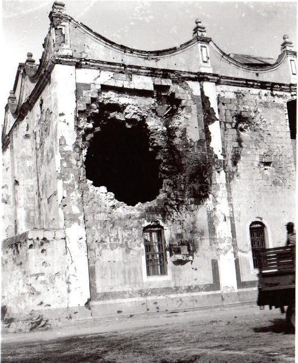
San Agustin Church after the battle, with a huge cannon shell hole at the southeastern corner along General Luna Street, close to the tomb of Miguel López de Legazpi, which may have been caused by a shell ricocheting when the American artillery north and south of City Hall was trying to breach the eastern wall of Intramuros
While the battle for Intramuros was raging, my aunt and her children had taken refuge inside San Agustin church and these two young boys were playing near the tomb of Miguel López de Legazpi, to one side of the altar close to the eastern wall of the church. When a cannon shell struck the church wall above them they were killed instantly. They were brothers belonging to the Yuste Family. Their father was a ship’s captain for a local shipping line whose ship was commandeered by the Japanese Navy early in the war; he was never seen again.
To conclude, upon the entry of some units of the U.S. 11th Airborne Division into the Pasay area, south of Manila, our house in the F.B. Harrison
Street area was looted and burned by the Makapili (Patriotic Association of Filipinos), the pro-Japanese trained militia.
It was very providential that my parents had locked up our house in F.B. Harrison sometime late in 1944 to accompany my widowed grandmother, Cenona Vda. de Mendez, her recently widowed daughter, my aunt Paz Mendez Claramunt, Filemon, and a woman helper living in Pedro Guevara Street. Otherwise, we may well have suffered the same fate as our deceased grand-uncle and uncles!
This was our joy of the liberation and the sorrow of the aftermath.
The Manila Jockey Club at the northern end of Pedro Guevara and Governor Forbes Streets after the liberation. Late during the occupation it was used as a Japanese military hospital, and was also used for some months during the liberation as a U.S. Army Emergency Hospital.
The Battle of Manila: Poisoned Victory in the Pacific War
reviewed by Andoni F. Aboitiz
The Battle of Manila: Poisoned Victory in the Pacific War by Nicholas Evan Sarantakes
Oxford University Press, February 2025
ISBN: 978-0199948857; hardback, 504 pp; £23
Anew book on the destruction of Manila is appropriately subtitled, as the reader will find out. Written by an associate professor in the strategy and policy department at the U.S. Naval War College, The Battle of Manila: Poisoned Victory in the Pacific War is a military history of the battle. With new perspectives and interesting questions the book gave this reviewer a different understanding of what happened in Manila in February 1945. If the reader is a student of this seminal event in Philippine history I am certain you will, like me, end the book with many ‘what if’ questions.
Mostly, the story recounts the decision-making process of the American military command that led to the tragedy that was the Battle of Manila. This narrative is complemented by the author’s accounts of the actions taken by the Japanese Army and Navy forces and the reactions of the Americans. By far the main protagonist in these events is General Douglas MacArthur. There are, of course, different views on who was responsible for the destruction of Manila, but MacArthur plays a critical role in all of them.
This being the case, the book begins with an introduction to the giant personality MacArthur was in the American public psyche. In addition, an extensive discussion of his command is presented and helps to explain how the battle played out.
The action begins at Lingayen Gulf, where the Americans successfully landed. The relatively easy establishment of a beachhead quickly led MacArthur to desire a quick dash for Manila. The liberation of the city was always MacArthur’s main objective for reasons that are expounded upon. It was far from the unanimous opinion among his officers that this was the best course in conducting the fight for Luzon.
The author guides us through the strategic, tactical and operational discussions that arose on the plan. Once the decision was made, MacArthur created a three-way race that Sarantakes argues was marked by poor intelligence, hubris and emotion. These factors would have unfortunate consequences as the battle unfolded.
In tandem, the book shows how and why the Japanese prepared for the defence of Manila, with Rear Admiral Sanji Iwabuchi infamously disobeying General Tomoyuki Yamashita's orders to withdraw from the city after destroying key infrastructure such as the ports. It is at this stage in the narrative that my ‘what if’ questions begin to surface.
The battle began as the U.S. Army 1st Cavalry Division rushed into Manila from the north to liberate the internees at the University of Santo Tomas in the evening of 3 February, 1945.
Malacañan Palace was reached and captured at approximately the same time, with both events catching the Japanese off guard, as they expected the American push to come from the south. This would not happen to the Japanese again.
The Americans underestimated the strength of the Japanese defence forces and misgauged their resolve to defend the city. Wishful thinking overcame MacArthur, and he failed to provide the strategic direction to capture the city intact. In fact, planning for a grand victory parade had begun to take an enormous amount of his energy, highlighting the disconnect between MacArthur’s command post in Hacienda Luisita, Tarlac and the situation in Manila before he entered the city.
From here, the book takes us through the fighting in the various districts as the Americans adapted to urban warfare and the Japanese resolve stiffened. It is worth noting that the Japanese defence is described as poorly coordinated, ill-led and largely relegated to last stands in pockets. This played a part in MacArthur's decision to allow large artillery pieces to be used against the Japanese to reduce American casualties.
The pressure on MacArthur to allow aerial bombardment and large-scale artillery assaults grew as the Americans realised they would not simply walk into Manila and that the Japanese were defending almost every building. MacArthur initially refused these requests so as to spare the city and its inhabitants from largescale destruction. But the American casualties were high, and the progress of the battle ‒which MacArthur had told the press would be over in early February ‒ was slow. He was forced to relent and allow his generals to conduct the battle as they saw fit, except for aerial bombardment. The generals did not hesitate and unleashed their massive guns on the Japanese, the city and its people.
For this reviewer, it was difficult to realise that the U.S. Army put the welfare of its soldiers over and above that of the Manileños, the capital city of a soon-to-be-independent nation, and its priceless heritage. While understandable from the American point of view, it is nevertheless a tough read. The relatively indiscriminate shelling
of Manila by the Americans was a major reason so much of the city was levelled. The author does his best to ensure the reader does not miss the fact that the Americans were reluctant bombardiers, and the decision of the Japanese to fight to the death gave the American military little choice. Or did it?
The last chapters of the book recount the military response to the Japanese holdouts on Corregidor Island, in Intramuros, and at the three most important government buildings (Legislative, Agriculture, and Finance). The staggering volume of firepower and ordnance which rained down on Intramuros and these three buildings is described in great detail. This narrative is remarkable because it again demonstrates which actions destroyed Manila. Firepower is a recurrent theme of my review, as it deserves much more study and understanding.
The Battle of Manila officially ended on 3 March, 1945 as the last Japanese holdouts in the Finance Building were eliminated. The author does a marvellous job in keeping the reader apace with the length of the battle. One feels a sigh of relief as the end is reached and the city goes quiet.
The last two chapters deal with the aftermath of the struggle and, in my opinion, are the most poignant. Manila had been laid to waste, and the misery of the civilian population is aptly described. Political questions are raised as well, some of which never occurred to me. Civil war was apparently a great fear for President Sergio Osmeña, suggesting the state of flux in Manila in February 1945. Similarly, the question is asked why the Americans were so openly welcomed when they had destroyed so much of the city. Interestingly, that is a wound that never opened.
As an in-depth look at the battle using both original research and American, Japanese and Filipino sources, this book is excellent – mostly military history, with more information on the Japanese side than I have previously come across. I highly recommend it to anyone seeking a new perspective on the Battle of Manila
Manila Bay: A History in Maps, Memories and Images from the Spanish Encounter to the Present by
Mark Lim
MANILA BAY is central to Philippine history, influencing its settlement, economy, politics and global significance. Its geography as a large, deepwater, natural harbor made it a center for global trade and a strategic prize for military engagements throughout history. This article traces the evolution of the bay in the imagination of those who encountered it. It shows how the shape of the bay in maps has evolved with increasing knowledge over time until recently, when we decided to reshape the bay with reclamation. It recounts the impressions of those who entered the bay for the first time, and during the most pivotal moments in Philippine history. And it notes how the point of view of those who created images of the bay has changed over time. To understand how memories have captured images of the bay is to understand the history of the bay and the nation.
Introduction
Without the large bay nearly surrounded by land and sheltered by mountains on either side, and the river that empties into the bay at the tongue of land that is Intramuros, there would not have been a settlement that grew into the city of Manila. Without the safe harbor provided by the bay, Manila would not have been the hub of global trade it became during more than two centuries of the Galleon Trade.
The sprawling, fertile and flat hinterland of the Tagalog and Kapampangan regions, easily accessible through the Laguna de Bai, and the rivers emptying into the bay from the north, made it sensible for the Spanish to relocate to Luzon from the Visayas to establish a sustainable foothold for the westernmost end of their global colonial empire. In a way, the shape and geographic realities of Manila Bay influenced not only Philippine but also global history. And to understand Manila and its place in history and the contemporary world, it is critical to understand its geography and how it was imagined by explorers, cartographers and artists throughout the ages.
Why Study Manila Bay?
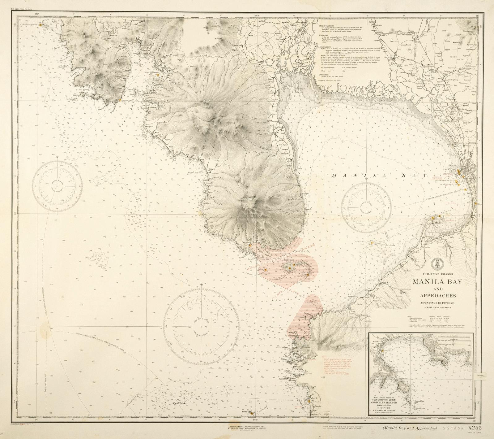
With an area of 1,994 sq. km., a length of 48 km. from north to south, and a shoreline of 190 km., but with a narrow opening to the West Philippine Sea of only 18 km., Manila Bay is one of the largest natural, deepwater harbors in the world. Larger than famous harbors such as New York, San Francisco, Sydney and Tokyo, it is big enough to shelter entire fleets, making it strategically important throughout history.
Despite numerous efforts to devolve power and wealth from Imperial Manila, the area surrounding the bay remains the undisputed center of the Philippines. Based on the 2020 census, around 24.7 million people (projected to be 27 million in 2025) live in the cities and provinces surrounding the bay. That swells to 33 million people if Rizal and Laguna, both integral to the Greater Manila Area conurbation, are included. This region is one of the largest and most densely populated urban agglomerations in the world, comparable in size to Delhi, Jakarta, Shanghai and Tokyo. It also means more than one in four Filipinos live around the bay.
While there are ongoing attempts to make the Subic and Batangas ports more attractive, the ports of Manila Bay continue to dominate trade statistics, especially for containerized trade. According to the Philippine Ports Authority (1), of the 7.84 million TEUs (container units) handled throughout the country in 2024, a combined 5.44 million TEUs (69.5%) passed through the three major terminals in the bay – Manila South Harbor, Manila North Harbor and the Manila International Container Terminal. Economically, the Manila Bay area remains the heart of the Philippines. Despite constituting only 15% of its land area and containing at least a quarter of its population, it generates 13.3 trillion pesos out of the country’s GDP of 24.4 trillion pesos. This means 54% or more than half of the economic output of the Philippine economy is created around the bay.(2)
Furthermore, according to Antonio ‘Tony’ Oposa Jr, the Verde Island Passage between Luzon and Mindoro is the ’apex of the apex of marine biodiversity in the world’, being a part of the Coral Triangle. Perhaps surprisingly for many, there are 51 genera of corals and 167 fish species in the bay.(3)
The ecosystem of the bay is much larger than its immediate coastline as the watershed includes all land drained by the 17 rivers that flow into the bay, bordered by the Zambales and Caraballo Mountains in the north and the Sierra Madre Mountains in the east. That means that even parts of Tarlac and Nueva Ecija are considered part of the Manila Bay region.
As well as the demographic, economic, political and environmental facts, the geography of the bay as expressed in maps is essential to understanding the Philippines. If not for the geographic imperatives of the bay, Manila would not have become the country’s capital and, arguably, the Philippines would not have become the Philippines.
Earliest Maps of Luzon
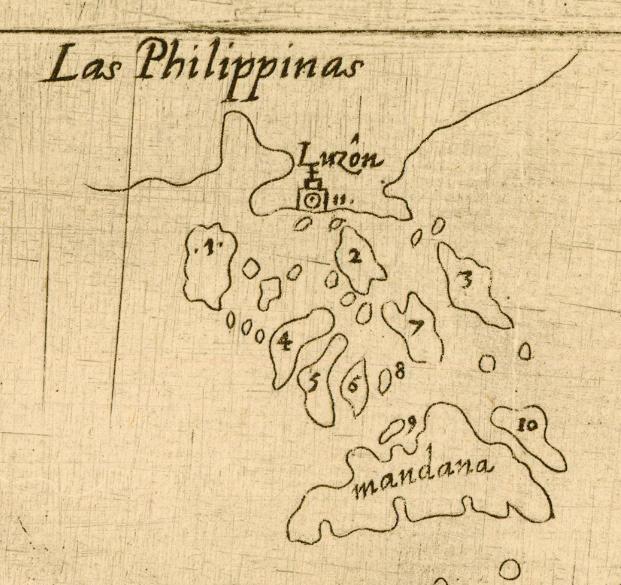
The earliest maps of the Philippines, derived from the voyages to the central and southern areas of the archipelago by Ferdinand Magellan and other early Portuguese and Spanish explorers, mainly show Mindanao, Palawan and many of the islands in the Visayas
Detail of Las Philippinas showing Manila Bay from Descripcion de las Indias del Poniente by Antonio Herrera y Tordesillas, Madrid, 1601 (image courtesy of the John Carter Brown Library)
of Luconia with
from Asiae
c.1589 (image courtesy of the Newberry Library)
Detail of Manilha from the ‘Spice Map’ by Petrus Plancius, Amsterdam, c.1594 (image courtesy of Leen Helmink Antique Maps)
To pinpoint the first map of Manila Bay is, therefore, to look at the earliest depictions of Luzon. The 1575 manuscript map of the Pacific Ocean by Juan López de Velasco shows the southern coast of Luzon (unnamed) with an inlet that is Manila Bay. The island is incomplete, an indication that no one had yet circumnavigated it as the map was drafted barely four years after Miguel López de Legazpi conquered Manila. In 1601 Velasco’s map was copied and published in Madrid with the title Descripcion de las Indias del Poniente by Antonio Herrera y Tordesillas.
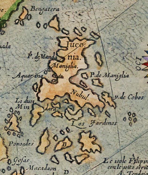
Another early map is Asiae Nova Descriptio by Giovanni Battista Mazza, published in Venice in c.1589. An adaptation of the 1570 map of Asia by Abraham Ortelius, this is believed to be the first complete map of the island of Luconia (Luzon),
Detail
Maniglia
Nova Descriptio by Giovanni Mazza, Venice,
together with some outlying islands to the east.(4) The inlet of Manila Bay is clearly shown, but is inaccurate in that the Bataan peninsula is omitted. It does show an island at the entrance of the bay, probably the first depiction of Corregidor.
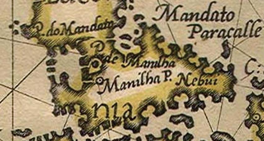
One of the earliest detailed maps of Southeast Asia is the celebrated Spice Map by Petrus Plancius, so named because of the illustration of nutmeg, cloves and three colors of sandalwood at the bottom. The map, designed to stimulate Dutch investment in the Spice Trade, was first published in Amsterdam by Cornelis Claesz in 1592-94 In this map, Manila Bay is shown as an inlet with an opening to the west, but the peninsula of Bataan consists of only two tiny protrusions. There are also two islands at the mouth of the bay.
This erroneous depiction of Manila Bay continues in Exacta & accurata delineatio , the map of Southeast Asia by Jan Huygen van Linschoten published two years later in the account of his travels, the Itinerario. It was from this map that Insulae Philippinae, the 1598 miniature map by Pieter van den Keere (aka Petrus Kaerius) was copied. This famous map is historic for being the first individual map of the Philippine archipelago. Again, there are two landforms protruding from the north side of the bay, but they hardly resemble the Bataan peninsula.
The Spanish Conquest
The first pivotal moment in the history of Manila Bay was when the Spanish finally took the decisive step of conquest. Legazpi’s expedition arrived in the archipelago in 1565, and five years later he sent Martín de Goiti and Juan de Salcedo on a mission to explore and conquer the supposedly rich northern kingdom of Manila in Luzon. Below is the first recorded impression of the bay, taken from an anonymous Relation of the Voyage to Luzon in May 1570:
In the afternoon they came in sight of a very large bay, which formed a wide gulf. It resembled a narrow sea with its entrance at that point; but the guides affirmed that the land was one, and so it proved to be when we entered the bay. … The land all around this bay, in the part where we anchored, and which the guides declared to be the port of Manilla, was really marvelous. It appeared to be tilled and cultivated. The slopes were smooth, and had but little herbage. In fact, so excellent indications have not been seen in this land, as were seen there.(5)
Another version of this description of Manila by an anonymous eyewitness records:
The entrance to the port of Manila is from the west, where the sea forms a great basin thirty leagues in extent. Within the bay is Manila and many other towns as well, along the shore.
Insulae Philippinae by Petrus Kaerius, Middelburg, 1598 (left) with (above) detail of Manila Bay (image courtesy of Leen Helmink Antique Maps)
Manila itself is on a promontory between the river and the sea; ... the land all round this bay was really marvelous, tilled and cultivated everywhere, smooth slopes cleared of jungle. Nowhere have we seen in these islands such a splendid sight.(6)
These observations on the size of the harbor and the excellent tilling conditions help us to understand why the Spanish chose Manila to be the capital of the future country.
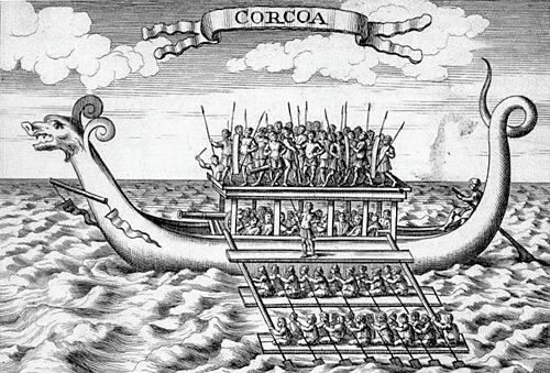
Initially friendly, Rajah Sulayman (aka Sulayman III), the Crown Prince of the Kingdom of Maynila, attempted to resist but was defeated in the first battle of Manila on 24 May, 1570. A year later, Legazpi himself led an expedition to establish the Spanish presence in Manila. He took possession of the city on 16 May, 1571 and was received peacefully by Bunao Lakandula of Tondo, Rajah Matanda and, after some delay, Sulayman. However, natives from neighboring areas refused to accept the foreign incursion knowing they would be next. At the head of an army of 2,000 followers from Agonoy and Macabebe in 40 karakoas (outrigger warships), Torik Sulayman of Macabebe (not to be confused with Rajah Sulayman) led his troops down the Pampanga River and converged at an estuary north of Manila called the Bangkusay channel. It was a natural meeting point north of Manila for those coming down the river.(7)
Legazpi attempted to make the resister submit through Lakandula, but Torik Sulayman refused vehemently and their forces were joined in a naval battle on 3 June, 1571. The Spanish boats, fastened two by two, rowed closer to the resisters. When they were in close range, the
arquebusiers started firing and scattered the forces of Sulayman. Unfortunately, the rebels could not overcome superior Spanish arms. The young, brave Torik Sulayman was killed and most of his followers fled; up to 400 were captured and later sold as slaves.(9) Thus ended the lastditch resistance of the natives of Luzon against Spanish conquest. A few weeks later, Legazpi founded the ‘ever loyal’ city of Manila.
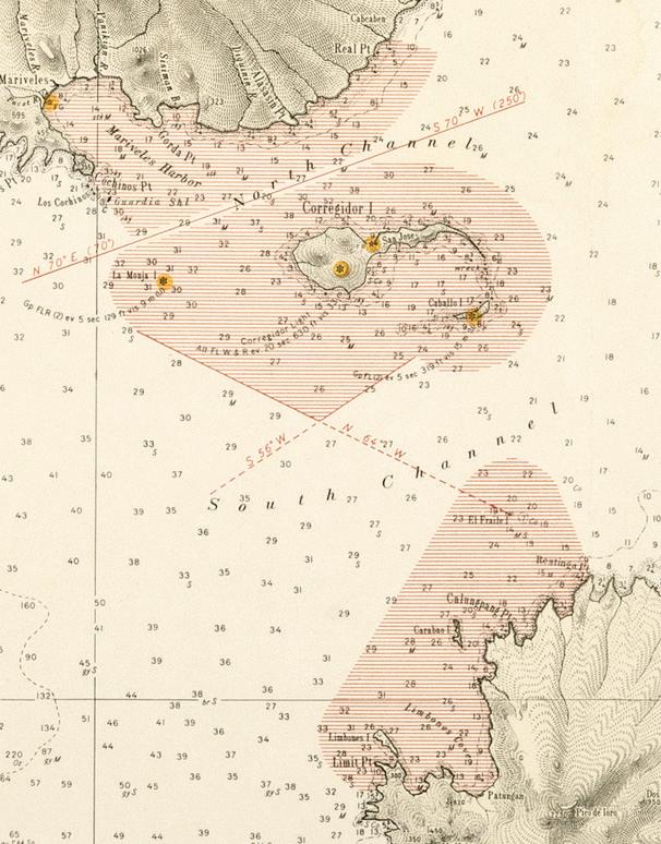
There are no contemporary maps of the area. 17th and early-18th century Dutch maps show channels north and east of Manila but do not name them. The earliest chart showing Bangousay (Bangkusay) is by J-B.N.D. d'Après de Mannevillette (see page 39 below). This channel no longer exists today as it has been paved over, and the coast is now much farther out because of reclamation for the North Harbor.
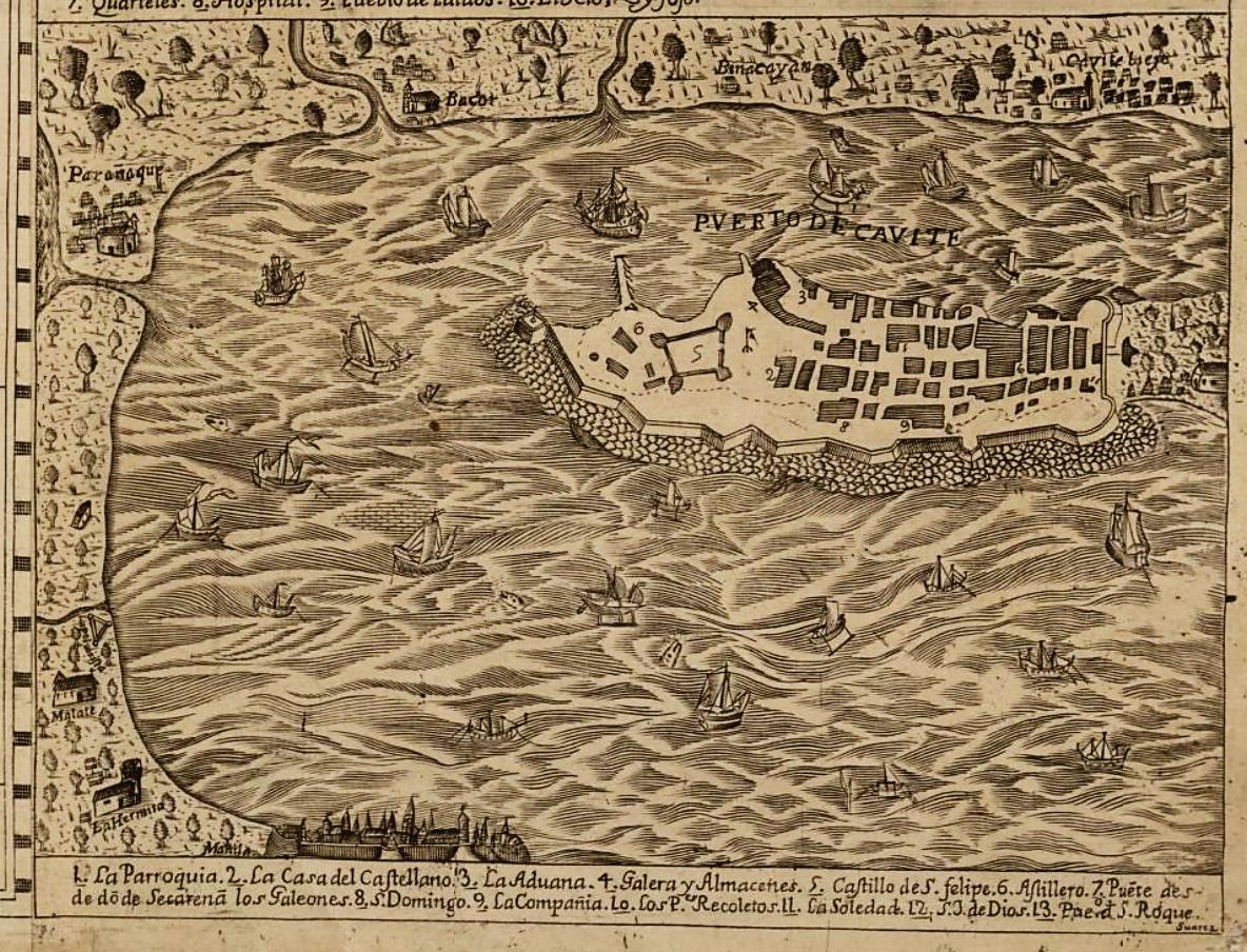
However, the colonization by Spain did not result in the publication of more accurate Spanish maps as charts were considered a state secret. The Padrón Real (royal register) – later the Padrón General (general register) – was the official Spanish master map; kept in the Casa de Contratación in Sevilla, it served as the template for the secret maps used on all Spanish ships during the 16th century. The first maps of Manila Bay were in fact made by the Dutch during their Golden Age of cartography, followed by French maps. The wider world, therefore, knew about Manila and the Philippines mainly from the eyes of other foreigners, who saw it as a potential prize, and not from the country’s own overlords. The earlier maps are depictions of naval battles, and until the mid-18th century not many settlements are shown other than the fortified city of Manila and the naval station that is Fort San Felipe.
Battle Pictures as the First Maps of Manila Bay
The early-17th century depictions of Manila Bay are not even proper maps, but portrayals of naval battles between the Spanish and the Dutch. The geography is shown as a backdrop to the pictures that illustrate the importance of the battle for supremacy in the East Indies between Spain and Holland, a former possession of the Habsburgs and at that time still not recognized as independent by Spain. The long Dutch struggle for independence from Spain was part of the Eighty Years War (1566-1648), and for nearly half
18th century engraving of a karakoa (image courtesy of University of Michigan Library)(8)
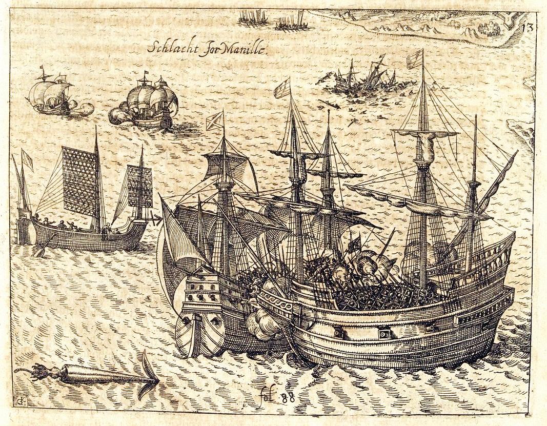
Schlacht for Manille by Johann Theodor de Bry, Frankfurt (1602) 1633 (image courtesy of Paulus Swaen Rare Antique Maps & Prints)
a century the Spanish and the Dutch waged fierce battles in Manila Bay and across many other Philippine seas for control of Manila and the lucrative Galleon Trade. Nick Joaquin called it the Great War and argued it was the most consequential struggle of all, even more than the Philippine Revolution, because had the Dutch won there would not even be a Philippine history to speak of.(10)
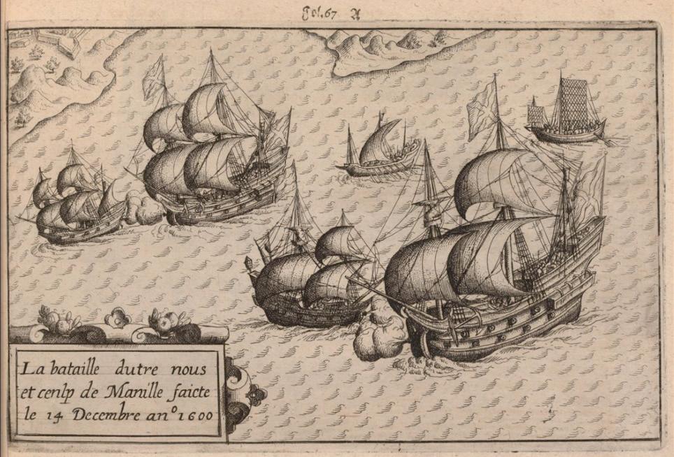
Schlacht for Manille, a print by Johann Theodor de Bry first published in Frankfurt in 1602, shows the famous clash between the San Diego, led by Antonio de Morga as captain general of the Spanish fleet, and the Mauritius under the Dutch captain Olivier van Noort. This was one of many skirmishes ultimately won by the Spanish. The two Dutch ships stayed near Corregidor at the mouth of the bay for a month and were then engaged by the Spanish forces in December 1600. One of van Noort’s ships, the Enderacht, was captured but he managed to sink the San Diego, the treasures of which were recovered in 1992 and are now displayed at the National Museum of the Philippines. There is a gleeful aspect to de Bry’s drawing of van Noort sinking the Spanish admiral’s ship.
More drawings of the engagement were subsequently published by Cornelis Claesz in Amsterdam in 1602 to accompany van Noort’s own account of his circumnavigation of the globe. The first shows the Dutch and Spanish ships engaged in a protracted battle, with the fortress visible in the top-left corner. As shown in the second illustration:
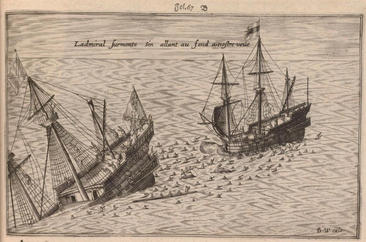
The Mauritius was rammed and entered by the Spanish admiral’s ship but the Dutch were able to defend themselves until a fire broke out and the Spanish had to retreat. The Mauritius then opened fire and caused such damage that they sank the admiral’s ship.(11)
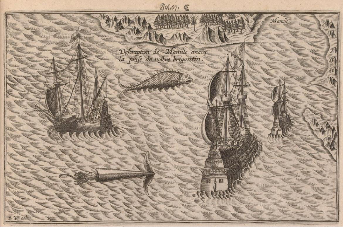
The third image shows the aftermath, with the Mauritius on the left, the remaining Spanish ship with the captured Enderacht on the right, and an enormous fish and a giant squid interposed. Van Noort realized his ship was too damaged to continue fighting so he sailed on to Borneo.
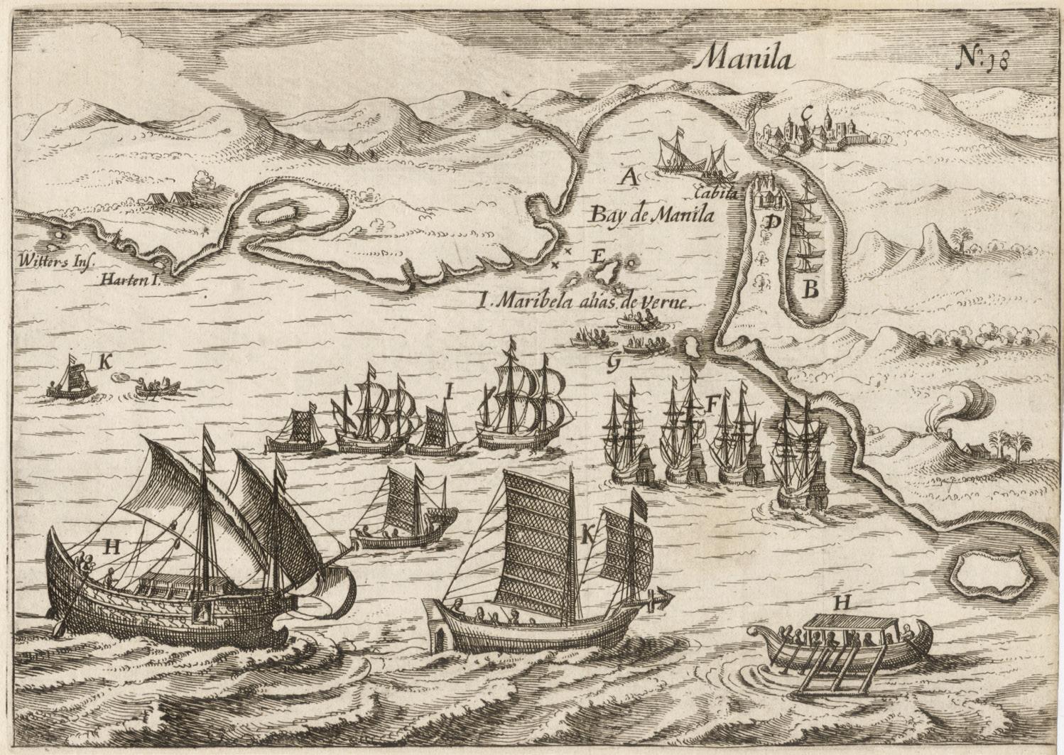
The earliest proper image of Manila Bay is an untitled view by the Dutch naval officer, explorer and privateer Joris van Spilbergen.(12) An accompanying map shows the track through the
San Bernadino Strait towards Manila Bay taken by van Spilbergen’s six ships during his visit to the Philippines. In the print the bay is shown as little more than a U-shaped inlet with an exaggerated ‘Cabita’ (Cavite) peninsula on the right-hand side
Engravings of the engagement between the Dutch and Spanish fleets in Manila Bay in December 1600, from the account of Olivier van Noort’s circumnavigation published in Rotterdam in 1602 (images courtesy of Koninklijke Bibliotheek Netherlands)
The bay is still dominated by ships in the foreground, but there are now more land features, including the ‘very populous’ town of Manila, the fort of Cabita (Cavite), and the island of ‘Maribela alias de Verne’(Corregidor).
La bataille dutre nous et cenlp de Manille faicte le 14 Decembre ano 1600
Ladmiral surmonte s’en allant au fond a nostre veue
˂ Description de Manille anecq la prise de nostre brigantin
Untitled view of Manila Bay by Joris van Spilbergen, Leiden, 1619 (image courtesy of Leen Helmink Antique Maps)
In 1616 van Spilbergen arrived in the Philippines and blockaded the mouth of Manila Bay. On 9 March, he anchored ‘off the island named Maribela, which has two very high rocks’; he notes that ‘the entrance is very dangerous in some places’.(13) His fleet approached the city and attempted to engage with the six Spanish ships sheltered behind Cavite fort where ‘we lay before the harbor, skirmishing with artillery the whole day’ (14) But he decided it was too risky and withdrew. He returned the following year but was decisively defeated at the Second Battle of Playa Honda off the coast of the town of Botolan in Zambales province. With his flagship sinking, van Spilbergen ‘withdrew with sorrow, our ships shot through, and many brave men slain’.(15) In the map, the blockade by the Dutch fleet seems to dominate the bay notwithstanding the fact the ships were ultimately chased away by the Spanish.
The conflict in the Philippines culminated in 1646 when there was a total of five running battles throughout the archipelago. The Dutch launched a full-scale invasion with 16 galleons in three squadrons while Manila had only two old galleons retrofitted for battle. The final engagement occurred on 4 October, 1646 off Corregidor with three Dutch galleons attacking an outnumbered Spanish warship, the Encarnacion, as the currents kept the other ships too distant. After four hours of furious bombardment, the Encarnacion managed to inflict significant damage on the Dutch ships, causing them to flee.(16)
This most improbable victory ended the Dutch menace and was attributed to the intercession of Our Lady of the Most Holy Rosary, dubbed La Naval. The barefoot procession of the soldiers after the victory started a four-century-old devotion to perhaps the most important Marian image in the country and is celebrated each October with a grand procession in Quezon City on the Feast of La Naval de Manila.
The battles between the Spanish and the Dutch continued to figure prominently in most of the maps of Manila Bay well into the following century. In many cases, they are represented by galleons dramatically exchanging cannonades and soldiers with pikes ready to board the enemy’s ship. Manila and Cavite are shown as formidable fortresses, while behind rise the hills
Illustration by Rafael del Casal from The Saga of La Naval: Triumph of a People’s Faith (Dominican Province of the Philippines, Quezon City, 2007)
of San Juan or the Sierra Madre. The Pasig and Zapote Rivers are prominently depicted. Later maps, in keeping with the earlier pictorial approach, emphasize the impact of these sea battles on the imagination.
Manille by the French engineer and cartographer Alain Manesson Mallet, from his Description de l'Univers published in Paris in 1683, shows Manila as a shining fortified city on a hill overlooking houses along the foreshore, while a battle rages at the mouth of the bay. There is also a fortified tower with a smoking light station on the Bataan peninsula. This map is famous among collectors as there is an edition published by Johann David Zunner in Frankfurt in 1684 that is a mirror image, the result of the printmaker’s error in engraving the image itself on the copper plate rather than in reverse.
The battle illustrations continued as late as 1724, when François Valentijn published his view of De Stad Manilha as part of his work Oud en Nieuw Oost-Indiën, a history of the Dutch East India company. Based on the manuscript by Johannes Vingboons, the print is more like a postcard than a map and is one of the most pleasing pictures of Manila Bay. Despite the failure of the many Dutch attempts to acquire a foothold in Manila, all of these maps – by de Bry, Spilbergen, Mallet and Valentijn – show how much they tried.
De Stad Manilha by François Valentijn, Dordrecht / Amsterdam c.1724 (image courtesy of Barry Lawrence Ruderman Antique Maps)
Manille by Alain Manesson Mallet, Paris, 1683 (left) and reversed edition, Frankfurt, 1684 (right) (Peter Geldart collection)
Detail of Manila Bay from Carta particolare dello
Stretto di Manilia nel Isole Filippine … d’Asia Carta VIIII, by Robert Dudley, Florence, 1646 (Peter Geldart collection)
17th-century Maps of Manila Bay
Apart from the Dutch maps obsessed with the battles to capture Manila, there were other maps of the Philippines by European cartographers that help us understand how Manila Bay was viewed at that time. There are two points worth noting: Manila Bay and Laguna de Bay were viewed as interconnected, almost as if they were one body of water; and in some of these early maps, the toponym used for the bay was Bay of Cavite instead of Manila Bay. For example, Robert Dudley’s chart Carta particolare dello
Stretto di Manilia nel Isole Filippine … Carta VIIII
Detail of ‘Baie de Cavite’ from Les Isles Philippines by Nicolas Sanson, Paris 1652 (Alberto Montilla collection)
shows ‘Il Porto di Manilia nominato Cabite’. The chart, from Dell' Arcano Del Mare published in Florence in 1646, was copied from Spanish charts or from charts from the Thames School of cartographers, and the soundings in the bay may have been obtained from Sir Thomas Cavendish, who sailed through the Philippines in 1588 on his circumnavigation of the globe.(17)
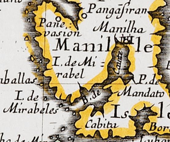
In 1652 Les Isles Philippines by Nicolas Sanson shows Manila Bay and Laguna de Bay as a single body of water, such that there is a large daggerlike inlet all the way to the heart of Central Luzon.(18) It is also the first map to use the toponym ‘Baie de Cavite’, which is subsequently repeated in maps by Pierre du Val in 1663 (19) and (as the ‘Gofo Cavite’) on a globe gore by Vincenzo Coronelli published in Venice in 1688. It is unclear why Sanson chose to name the bay after Cavite when other maps such as that of de Bry call it the Bay de Manila as early as 1602.
Detail of Manila Bay / Laguna Bay from Planta de las Islas Filipinas by Marcos de Orozco, 1659 (Rudolf J.H. Lietz collection)
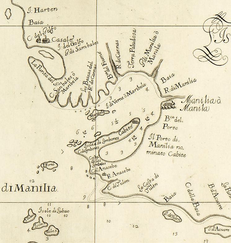
Another notable map is the 1659 Planta de las Islas Filipinas by Marcos de Orozco, published in Labor evangélica, a history of the Jesuits in the Philippines by Fr. Francisco Colin at a time when Spanish maps were still a state secret under the Padrón Real. (20) Oriented to the south, the map again depicts Manila Bay and Laguna de Bay as one body of water. Manila Bay is roughly circular. Places like Todo (Tondo), Bancosej (Bangkusay) and Nabotas (Navotas) are named and shown as islands. Cavite is noted, as well as Maragōdō (Maragondon) and Bata (Bataan), while Corregidor is still named Mariveles. The location of Manila is marked by a large cross with the note ‘y enla † es Manila y su arçobispado lo colorado’.
Manila Bay and the Galleon Trade
In my conversation with Alfredo Roca, a founding member of PHIMCOS and a trustee of the Museo del Galeón, he argued that Manila was the center of Asia in the 18th century and the hub of the global trade network provided by the ManilaAcapulco galleons based on geographic imperatives. He explained that in the 1570s Juan de Salcedo explored Lake Bombon (Taal Lake), which at that time still had access to Balayan Bay, and considered it as a potential site for the capital because of its fertile surrounding lands But Manila Bay proved more suitable because of its large, protected harbor, its connection to Laguna de Bay and surrounding rice lands through the Pasig River, and its existing connection to the trade routes with China and the rest of Asia. Moreover, many of the galleons were built in Cavite because at that time the province was full of hardwood forests.
The Italian adventurer Giovanni Francisco Gemelli Carreri undertook a five-year voyage around the world. In 1697 he arrived in Manila and stayed for two months before booking a passage on the galleon bound for Mexico. In his famous account, Giro del Mondo, he describes vividly the riches he saw in the global entrepot that was Manila:
As for Manila, the Author of Nature placed it so equally between the wealthy Kingdoms of the East and the West that it may be accounted one of the greatest Places of Trade in the World … . For here are found the Silver of New Spain and Peru; and for the East, the Diamonds of Golconda, the Rubies, Topazes, Saphires and precious Cinnamon of Ceilon; the Pepper of Sumatra and Java; the Cloves and Nutmegs of the Molucos; the Pearls and rich Carpets of Persia; the fine Silks and Stuffs of Bengala; the Camphire of Borneo; the Benjamin and Ivory of Camboia; the Musk of Lequios; the Silks, Muslins, Callicoes and Quilts, with the curious Purcellane, and other Rarities of China.(21)
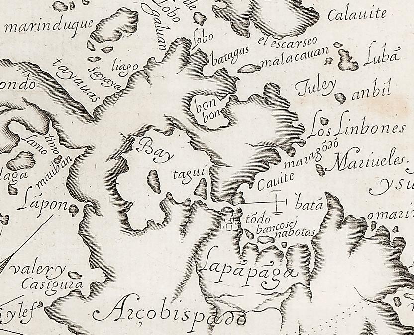
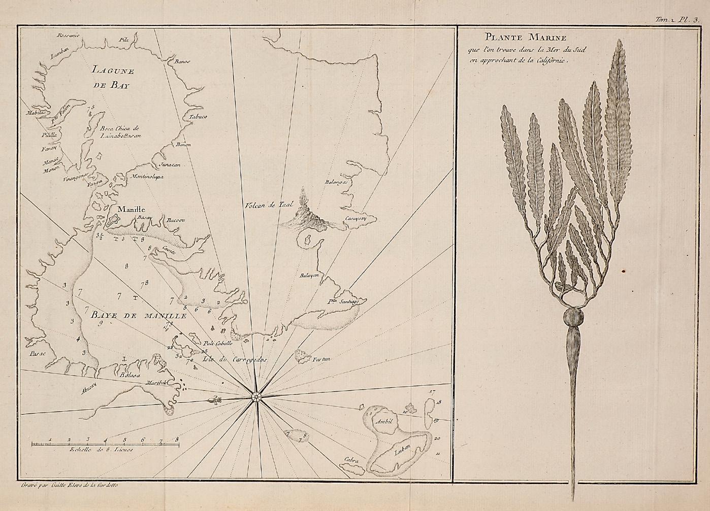
The routes of the Manila Galleon through the San Bernardino Strait and around the north of Luzon are shown on the 1734 Carta Hydrographica y Chorographica delas Yslas Filipinas by Fr. Pedro Murillo Velarde – the most celebrated and coveted of all Philippine maps because it is not only the most beautiful but, at that time, the most accurate. The shape of Manila Bay is closer to reality, although it is still a simplified inverted U-shape rather than the ‘big foot’ shown on Mallet’s map, but Bataan is finally shown as a significant peninsula. The northern shore of the bay, where the Pampanga River empties into a delta, is shown as a series of small islands.
Detail of Manila Bay and adjacent provinces and river systems from Carta Hydrographica y Chorographica delas Yslas Filipinas by Fr. Pedro Murillo Velarde, Manila, 1734 (image courtesy of the Library of Congress)
Panel inset of the Puerto de Cavite from the 1734 Murillo Velarde map (image courtesy of the Library of Congress)
Corregidor is now named as such and other islands such as Monja, Frayle and Policavallo (Caballo) are shown at the mouth of the bay. Unlike many contemporary maps, the map also notes many of the towns surrounding the bay in Bataan, Bulacan and Cavite, as well as the towns north and south of Intramuros. Manila and surrounding districts such as Tondo, Santa Cruz and Quiapo are drawn as islands as indeed they were in the Pasig River delta.
The Murillo Velarde map is also famous for the twelve engravings in its two side panels, two of which are insets of the fortified settlements
around the bay: Manila and Puerto de Cavite. The latter is illustrated as a hook-shaped fortress on a peninsula surrounded by warships and many other boats. A large galleon is docked at Sangley Point, the port of departure and arrival for the Manila-Acapulco galleons – the terminus of one of the most important trade routes at that time, considered as a precursor to globalization.(22)
Vicente Memije’s famous print Aspecto Symbólico del Mundo Hispanico depicts the Spanish Empire as a queen with Spain as its crown and the trade routes across the Atlantic and Pacific as parts of her dress.(23) Manila and the rest of the Philippine archipelago constitute her slippers and, in a manner of speaking, without Manila Bay the empire would have had no feet on which to stand.
Other early 18th-century Maps of Manila Bay
After the pictures of battle, proper maps of Manila Bay drawn by European cartographers began to emerge. Most of these depict a roughly circular bay, probably drawn from descriptions of the bay as mostly surrounded by land, but without the benefit of a formal survey.
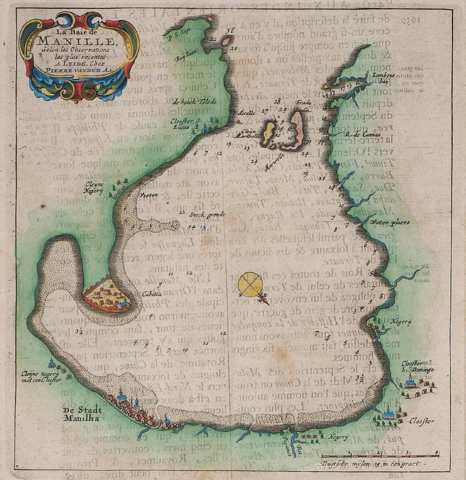
In 1719 the Dutch publisher Pieter (aka Pierre) van der Aa included a map of La Baie de Manille in a book about the travels of the German explorer J.A. von Mandelslo.(24) Van der Aa never
La Baie de Manille by Pierre van der Aa, Leiden, 1719 (left) and Manilhas Bay by François Valentijn, Dordrecht / Amsterdam c.1724 (right) (Peter Geldart collection)
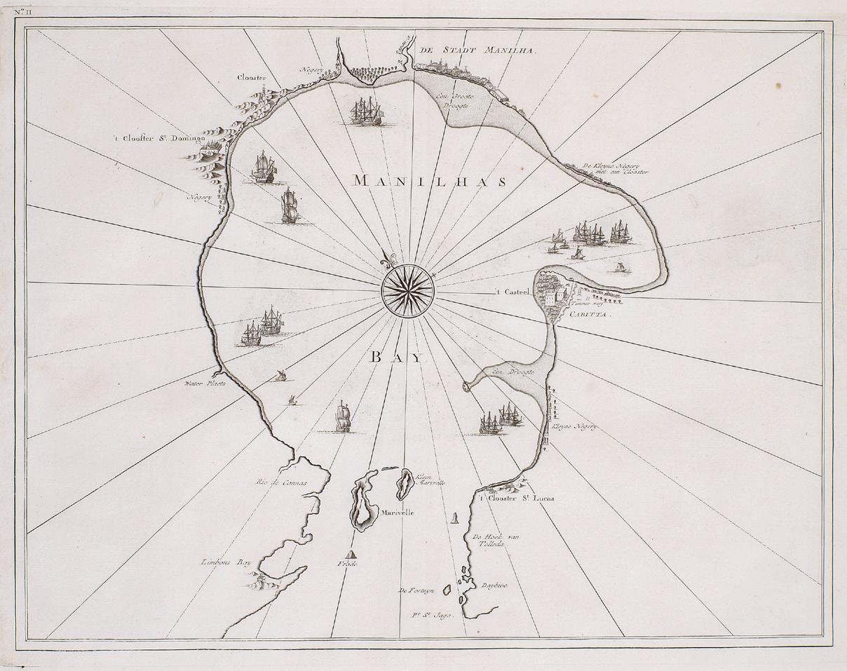
Nieuwe Aftekening van de Baay van Manilla by Johannes II van Keulen, Amsterdam, (1735) 1753 (Mariano M. Cacho, Jr. collection)
set foot in Manila so the map is likely based on the work of Dutch cartographers. Oriented to the southwest with a compass rose at the center, the map shows the bay as roughly circular in shape but tapered more towards its mouth at the top, and with a nose-like protrusion for Bacoor Bay. Other than the fortresses and the islands (with ‘Marivelli’ for Corregidor) at the mouth of the bay, there is not much detail. Some Cloosters (churches) are noted, but they seem to be inaccurate. Manilhas Bay, essentially the same map but oriented to the northeast with the mouth of the bay at the bottom, was published by Valentijn five years later in the same work as De Stadt Manilha described above.
A better map of De Baay van Manilla was produced by Johannes II van Keulen. Dated 1735 (but published only in 1753), the map has shifted orientation once more with Manila to the east and the mouth of the bay to the southwest. The shape of the bay is oval, with the Cavite peninsula now more closely resembling a hook. Except for the city of Manila and Fort San Felipe, located in
the port of ‘Cabitta’, no other settlements are shown other than Binondo, north of the Pasig River, with a note ‘Hier leggen de Chineese Jonken’ (here the Chinese junks lay).(25)
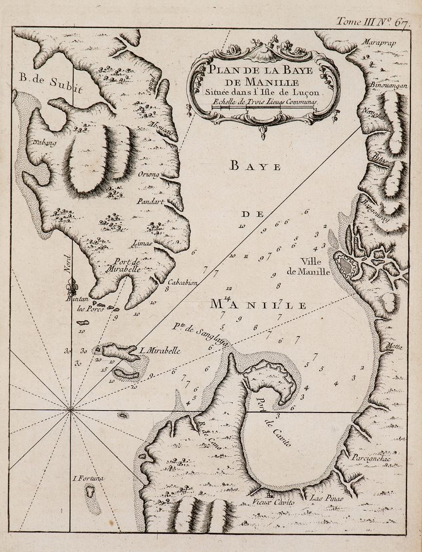
In 1745 J-B.N.D. d’Après de Mannevillette, Hydrographer to the French Compagnie des Indes, published the first edition of his sea atlas Le Neptune Oriental. Recognised in France and abroad as being superior to all existing charts of the eastern seas, the 22 charts it contains include a Plan de la Baye de Manille Capitale des Isles Philippines. Oriented to the west, the map shows Manila Bay as an irregular oblong. As well as the islands of Fortuna, Mirabelle (Corregidor) and ‘les Puercos’, the toponyms clockwise along the coasts of the bay are (sic): Bintam, Port de Mirabelle, Cabcabion, Limas, Pandart, Oriong, Aboucay, Samal, Boulacan, Bodbod, Binangsan, Sta. Crux, Siguinan, Maraprap, Binouangan, Navotas, Bitas, Bangousay, Manilla, Malta, Parcignekac, Laspinas, Cavito Vechio, Pte. de Sanglaya, Port de Cavito, and R. de Cano. To the north Sabang and B. de Subit are shown.
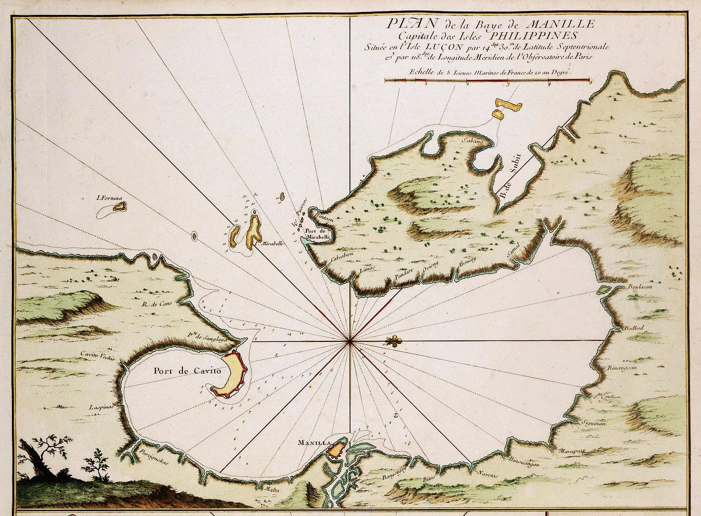
Plan de la Baye de Manille by J-B.N.D. d’Après de Mannevillette, Paris, 1745 (image courtesy of Paulus Swaen Rare Antique Maps & Prints)
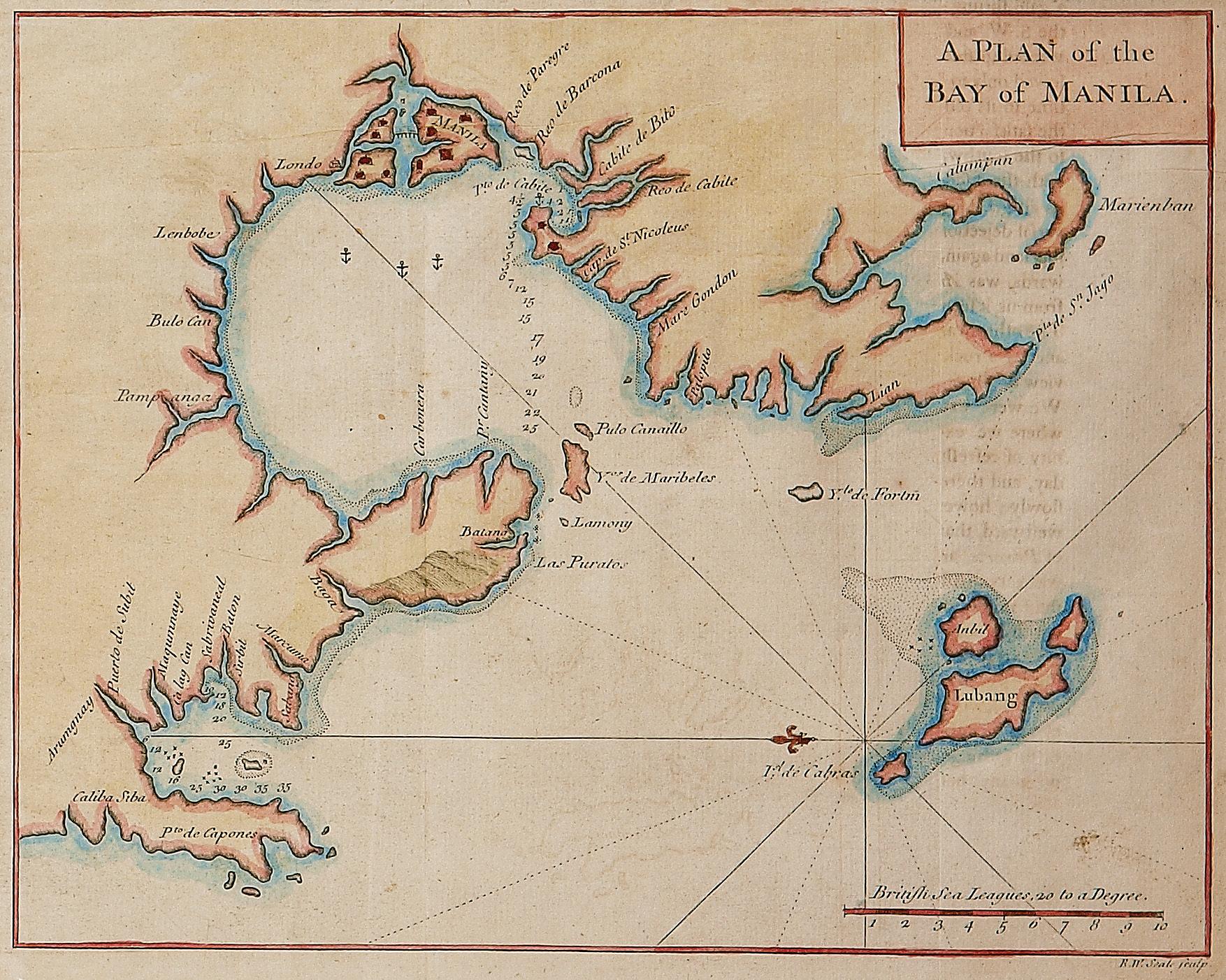
A Plan of the Bay of Manila, London, 1748 (Edgardo Angara collection)
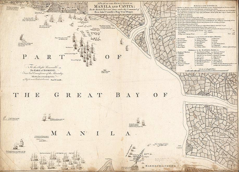
A Plan of the Reduction of Manila and Cavita By the British Fleet and Army, 1764 by Thomas Jefferys (image courtesy of the Norman B. Leventhal Map & Education Center at the Boston Public Library)
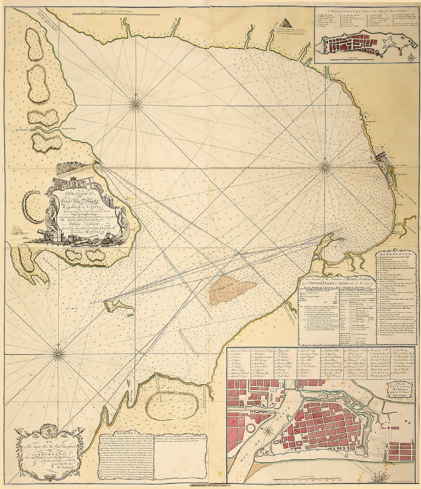
A Draught of the Great Bay of Manilla and Harbour of Cavita … by William Nichelson, London, 1764 (Vincent S. Pérez collection)
A Plan of the Bay of Manila, engraved by R.W. Seale, is from A Voyage Round the World, in the Years MDCCXL, I, II, III, IV, the account of Commodore (later Admiral) George Anson’s circumnavigation of the world published in London in 1748 (and in many subsequent editions). As Anson never actually saw Manila Bay the map must have been based on an earlier European chart, quite likely one of the Spanish charts taken in June 1743 when Anson in HMS Centurion captured the Spanish galleon Nuestra Señora de Covadonga, returning from Acapulco, near Cape Espiritu Santo.
Instead of portraying it centrally, on the map the bay itself is less prominent though still drawn as an irregular, circular shape in the upper left quadrant. More space is given to the Batang (Bataan) peninsula, Puerto de Subit (Subic Bay), Lubang Island, and the coast of western Batangas. Manila is depicted as an island linked by a bridge to one of two smaller islands north of the Pasig River off Londo (Tondo). Lord Anson, in his capacity as First Sea Lord of the Admiralty, would later approve the invasion of Manila and this map may then have been of military value.
The British Interlude
In 1762 Spain had joined France and Austria in the Seven Years War (1756-1763) and was at war with Great Britain and Prussia. This made Manila, the end point of the lucrative Galleon Trade and its treasure ships, a key target for the British so an expeditionary force under Colonel William Draper and Admiral Samuel Cornish was sent to capture the colonial capital. On 23 September they arrived at Manila Bay and found the Spanish (under the acting Governor-General, Archbishop Manuel Antonio Rojo del Rio y Vieyra) unprepared as they were not even aware they were then at war with the British.
Taking advantage of the confusion, Draper decided to assault Manila directly instead of taking Fort San Felipe first, which was the original plan. The British forces chose a landing spot two miles south of Intramuros near Malate Church. They landed the following day and occupied the loosely-guarded Polverista (Fort San Antonio Abad). In a matter of days they occupied the churches south of Intramuros and converted them into forts as they surrounded the city. By 2 October they were bombarding the walls; a breach was made three days later at the Baluarte
de San Diego. Less than a fortnight after their landing, Manila fell to the British on 6 October, 1762 (26)
The British were able to occupy only Manila and Cavite as the Spanish under Simón de Anda mounted a strong resistance. The Seven Years War ended with the signing of the Treaty of Paris in February 1763 – although the news reached Manila only in July – and the British left in April 1764. The interlude was infamous for the looting that occurred causing the loss of valuable treasures including the copper plates of the Murillo Velarde map, which were taken back to London and were either melted down or reused.
But the occupation of Manila did leave a lasting legacy in the form of maps and charts made by both British and Spanish cartographers, including Thomas Jefferys, Edward Cotsford, William Stevenson and Miguel Antonio Gómez The most impressive of these charts was by William Nichelson; to quote Peter Geldart:
The greatest cartographic legacy of the occupation is the magnificent chart titled A Draught of the Great Bay of Manilla and Harbour of Cavita; describing all the Islands, Rivers, Bays, Rocks, Sands and dangerous Shoals; with the Marks pointing out their true situation, and also how to go clear of them; Survey’d & drawn with great Accuracy by William Nichelson, Master of His Majesty’s Ship Elizabeth, at the taking of Manilla. This large chart (124 cm x 108 cm) in four sheets was engraved by John Spilsbury and published in London by William Herbert in 1764.
The ornate title cartouche is decorated with numerous images of British naval power, including figures of the gods Mars and Neptune, cannon, cannonballs, kegs of powder, anchors, a mortar, and other weapons; the Union Jack and the flag of St George are at the top, while the Spanish royal standard lies on the ground with its staff broken to signify defeat. In a second cartouche, the chart is dedicated ‘To the Right Honourable Lords Commissioners of the Admiralty’, and there are insets with ‘Remarks, An Account of the Reduction of Manilla & Cavita’ and References. Also inset is A Plan of the City and Suburbs of Manilla, Capital of the Island Luconia, which shows details of the attack, and there is a smaller inset of A Plan of the Town of Civita.(27)
Plan de la Baye de Manille by Jacques-Nicolas Bellin, Paris, 1764 (Christian Perez collection)
In 1963 Carlos Quirino wrote that the Nichelson chart ’has not been surpassed in accuracy for more than a century afterwards. The configuration of the shoreline was presented with such exactness and the depth figures agree so closely with recent surveys that this chart has been considered as practicable as any in existence today’.(28)
Late-18th century and 19th-century Maps
While the shape of the bay is accurate and the rivers emptying into it are shown, the Nichelson map is a sea chart and no details of towns are shown other than the fortifications of Manila and the Cavite peninsula. And despite the advance in its accuracy, not all subsequent maps followed its contours.
The Plan de la Baye de Manille by Jacques-Nicolas Bellin, published in Paris in 1764 in his fivevolume work Le Petit Atlas Maritime, shows the bay elongated vertically, with multiple depth soundings within and at the entrance to the bay (albeit far fewer than in the Nichelson chart). Bataan is clearly depicted as a long peninsula marking the western shore of the bay, and there are more towns and settlements with recognizable names around the bay. It is Cavite
province that is now shown a little too small as the inlet created by the Pointe de Sanglaya (Sangley Point) is exaggerated.
In 1775 Mannevillette published the second, greatly enlarged edition of Le Neptune Oriental. This included a Plan de la Baye et Ville de Manille that still depicts an elongated Manila Bay, separated from Laguna de Bay, but with a line of islands along the north shore of the bay in front of exaggerated river deltas giving access to the fertile hinterlands of Bulacan and Pampanga.
Published in 1781, a map oriented to the east shows the Baye de Manille and Lagune de Bay as a pair of circles connected like a barbel not by a river but by an inlet as if the latter were a part of the sea, thereby continuing the theme of interconnected waterways seen on the 1775 Mannevillette map. Corregidor is correctly named and its characteristic tadpole shape is mapped accurately. Balaoa (Balanga) is shown for the first time, with an anchorage. Cavite’s shoreline is more correctly drawn as sloping to the southwest. Bacoor and Basay (Pasay), towns to the south of Intramuros, are also well noted.
Plan de la Baye et Ville de Manille by J-B.N.D. d’Après de Mannevillette, Paris, 1775 (Mariano M. Cacho, Jr. collection)
Untitled map of the Baye de Manille by Antoine-Joseph Gaitte, Paris, 1781 (Leovino Ma. Garcia collection)
Plan de Manila, su Bahia y Puerto de Cavite by Eduardo Malo de Luque, Madrid, 1790 (image courtesy of Barry Lawrence Ruderman Antique Maps)
Curiously, it has an inset of a Plante Marine (marine plant) found when approaching California, attesting to the importance of the galleon trade at that time. The map, engraved by Antoine-Joseph Gaitte, was published in Volume II of Voyage dans les Mers de l’Inde by Guillaume Le Gentil de La Galaisière, a French astronomer who visited the Philippines in 1767-68.
The Plan de Manila, su Bahia y Puerto de Cavite, dated 1787 but published in 1790, is one of the most interesting maps of Manila Bay.(29) Oriented to the northeast, the map is by Pedro Francisco Jiménez de Góngora y Luján, Duque Almodóvar del Río, a Spanish nobleman, ambassador and historian known as Eduardo Malo de Luque (an anagram of ‘El Duque de Almodovar’). It is inaccurate geographically as the bay still looks like an elongated protozoan; the mapmaker is likely to have referred to Bellin’s 1764 map
The map is remarkable for noting practically all the major towns and settlements around Manila Bay, along the Pasig River and around Laguna de Bay. Their locations are denoted by a symbol indicating a parish church. Intramuros, exaggerated in size, is the main focus while the suburbs extramuros are also shown: Tondo, Binondo, Quiapo, Sampaloc, Santa Mesa and Santa Ana. South of Intramuros, Hermita (Ermita) and Malate are noted as well as the towns of Pasai (Pasay), Parañaque and Las Piñas. Many towns in the provinces of Cavite, Bataan, Pampanga and Bulacan are clearly marked. North of Manila, towns such as Polo (Valenzuela), Tambobo (Malabon), Caloocan, and Navotas are all named. So while not the most accurate geographically, it is the most accurate and complete political map of the bay area to date and would have been quite practical when traveling around the environs of the capital.
This was the start of the period of truly scientific cartography when detailed charts, produced by trained naval surveyors and published by the admiralties of Spain, France, Britain and (in due course) the United States, gradually replaced those of the commercial chart publishers. Hence, the maps now show features beyond military fortifications, documenting more of the land topography, the sites of towns and settlements, depth soundings for navigation, marine hazards, and even erupting volcanoes. The national hydrographic institutions no longer kept the
information secret; naval chartmakers openly shared their surveys and acknowledged their sources.
Manila Bay would now finally take its characteristic ‘foot’ shape. In 1798 the Depôt des Cartes et Plans de la Marine in Paris published its Plan de la Baye de Manille et de ses Environs Verifié sur la Frégate la Meduse en 1789. (30) While broadly similar to Mannevillette’s chart from 1775, the (1789) 1798 map now hews more closely to the actual shape of the bay, corrects for the ‘exaggerated islands’ surrounding it, and records more of the rivers that empty into it. Corregidor Island bears its present name instead of Mirabelle, and depth soundings cover about two-thirds of the bay.
At the top of the chart a coastal profile, Vue de la Côte depuis les Isles Cayman jusqu’à la Pte. O. de Marivelle, depicts the vista seen by sailors approaching Manila Bay from the northwest, from the Capones or Camara Islands all the way to the tip of Mariveles. Cinco Picos peak is shown above Silonguin (Silanguin) cove and Sampaloc point, the entry point to Subic Bay.
Plan de la Baye de Manille, Paris, 1798 (Peter Geldart collection)
Carta Esferica de la Bahía de Manila by Felipe Bauzá, Madrid, 1807 (image courtesy of the Biblioteca Nacional de España)
In 1792 the Philippines was visited by the fiveyear expedition to the Americas, Oceania and Australasia led by Alessandro Malaspina in the corvettes Descubierta and Atrevida with the aims of making scientific observations, reporting on the state of Spain’s overseas possessions, and producing accurate charts of their coastlines. The expedition spent several months in Manila and its cartographer, Felipe Bauzá y Cañas, produced a manuscript chart, Carta Esferica de la Bahía de
Manila, that was later engraved and printed by the Direccion Hidrografica in Madrid in 1807. The published Spanish edition was preceded by one published in London in 1798,(31) and a French edition appeared in 1808.(32)
Bauzá’s chart was the most accurate and detailed map of Manila Bay since the Nichelson chart, with depth soundings all around and across the bay, the overall shape of which closely resembles
the 1789 French chart. Most of the rivers and towns around the bay are shown, and key features of the terrain include the mountains of the Sierra de Maribeles (sic) and Pico de Loro. The characteristic tadpole shape of Corregidor is more accurately rendered. Along with the many rivers flowing from the Bataan peninsula, towns such as Orion, Balanga, Abucay and Orani are also clearly shown.
In 1830 the British Admiralty Hydrographic Office issued the first edition of its chart no. 976 Manila Bay, Surveyed by Don Felipe Bauzà, 1792; it was re-issued ‘with corrections’ in 1859. Then, in 1866, a new edition of chart no. 976 was published with the title changed to Philippines / Luzon Island / Manila Bay / Surveyed by the Spanish Philippine Hydrographic Commission under the direction of captain Claudio Montero 1861. The Admiralty would re-issue this chart numerous times, with ‘Large Corrections’ in 1876, 1885, 1886, 1897, 1902, 1903 and 1906.
In 1854 the Spanish naval ministry had decided that, given the importance of the Philippines and
its trade routes, it was necessary to undertake new, accurate surveys of the archipelago to replace those dating back to the Malaspina expedition. Consequently, the Dirección de Hidrografía formally established a cartographic commission specifically for the Philippines, the Comisión Hidrográfica de Filipinas, under the leadership of navy lieutenant Claudio Montero, an experienced cartographer. Between 1856 and 1864, Montero’s ships surveyed the entire archipelago.
His chart of Manila Bay (no. 482) was published in 1863 with the title Carta Esferica de la Bahia de Manila y sus inmediaciones. Levantado en 1861 por la Comision Hidrográfica al mando del Capitan de Fragata D. Claudio Montero. With the title later changed to Archipiélago Filipino – Carta de la Bahia de Manila …, the chart was reissued with corrections and additions in 1866, 1874, 1880, 1885, 1893 and 1906; an inset of the Plano del Puerto de Mariveles was also added. A large chart, it was the most accurate of its time, with the shape of Manila Bay and the Bataan Peninsula close to those shown on maps today.
Carta Esferica de la Bahia de Manila y sus inmediaciones by Claudio Montero, Madrid, (1863) 1880 (image courtesy of the Biblioteca Nacional de España)
Vue de Cavite dans la Baie de Manille, from a painting by Gaspard Duché de Vancy, 1787 (image courtesy of Rudolf J.H. Lietz / Gallery of Prints)
There are depth soundings around the entire bay and all the way into Laguna de Bay. Key topographical features such as Pico de Loro and its surrounding peaks, and the Sierra de Mariveles and Pico de Santa Rosa (Mount Natib) on Bataan, are shown in detail. More towns are also marked on the chart. Also notable are the lighthouses on Corregidor, Caballo Island, Sangley Point and Manila Harbor, all indicated in red and orange.
Prints and Paintings of the Bay
As well as maps and charts, in the late-18th century and throughout the 19th century prints of Manila Bay were also published, most of which show the view of the bay looking towards the city of Manila. This reflects that most arrivals to the country at that time came by ships entering the bay to dock at the ports of Cavite or Manila.
Vue de Cavite dans la Baie de Manille is a relatively famous print, from a painting made by the French artist Gaspard Duché de Vancy in 1787. Engraved by Jean-Baptiste Blaise Simonet, it was published in 1797 in the Atlas du Voyage de la Perouse that accompanied the official account of the scientific expedition led by the French naval explorer Jean-François de Galaup,
comte de Lapérouse. The print shows passengers on a rowboat presumably traveling from the port in Cavite to the city of Manila. In the background Fort San Felipe can be seen, along with several sailing craft and the peak of Pico de Loro. The passengers are shown wearing European clothes, perhaps through ignorance of Filipino attire at that time.
de la
(image courtesy of National Library of Australia)
People and cargo being transported in boats is a common subject at this time. Vue de la Ville de
Vue
Ville de Manille by Ludovik Choris, 1826
Entrée de la Baie de Manille …. avec les petits noirs des Montagnes by Gabriel Lafond, 1840 (image courtesy of Rudolf J.H. Lietz / Gallery of Prints)
Carayas ou machines à pêcher, et Banka de Manille by François-Edmond Pâris, 1840 (image courtesy of Rudolf J.H. Lietz / Gallery of Prints)
Manille by Ludovik Choris, published in 1826,(33) shows five sailors on a rowboat likely going from their ship to the shore. In the background are sailing ships, the spires of the churches in Intramuros, and the mountains of the Sierra Madre. Choris, a German-Russian painter and explorer, was part of the Russian Rurik Expedition, a scientific expedition led by Otto von Kotzebue, a lieutenant in the Russian Imperial Navy, and sponsored by Count Nikolai Petrovich Rumyantsev (aka Romanzoff) in 1815-18.
Entrée de la Baie de Manille (Iles Philippines) / Entrevue Nocturne de l’Auteur avec les petits noirs des Montagnes is a large lithograph by Gabriel Lafond published in 1840.(34) In this beautiful print of the mouth of Manila Bay with a view of Corregidor as seen from Mariveles, Lafond documents his encounter with indigenous Aetas during his voyage around the world in 1828. The Aetas live in tents. The nocturnal scene is dramatically illuminated by a full moon. There are several boats crossing the Boca Chica and a shipwreck is shown on the righthand side.
Rowing activity can again be seen on Carayas ou machines à pêcher, et Banka de Manille, a print by François-Edmond Pâris. The print, a lithograph by Charles Mozin, is part of a compilation of drawings of all sorts of watercraft that Pâris documented during his three circumnavigations of the globe (between 1826 and 1840) and published in 1843. It shows the ‘caraya’ or salambáo (salambaw), a lift net set up on a raft that is used by fishermen throughout the Philippines but is most prevalent in large lakes and sheltered coastal areas like Manila Bay. In the background, the lighthouse at the mouth of the Pasig River is visible.
Vista de Manila desde la Bahia by José Honorato Lozano, 1847 (image courtesy of the Biblioteca Nacional de España)
It is a windy day in Manila Bay and the sky is dark with clouds in the Vue de Manille, a print by August Nicolas Vaillant published in 1845.(35) Several boats transport people and cargo. The frothy waves have been beautifully colored in blue and green, while in the background are the white buildings of Intramuros and Binondo.
The Vista de Manila desde la Bahia is a watercolor by José Honorato Lozano from 1847. Lozano is famous for his letras y figuras, a form of painting in which letters of the alphabet –frequently spelling the name of a patron – are depicted in the shape of human figures, animals or plants. These watercolors, usually commissioned as souvenirs, were often accompanied by vignettes of the city. This painting shows a view of the city of Manila from the bay with its church towers rising above the surrounding walls. It is another windy day judging by the waves and the movement of the flags.
˂ Vue de Manille by August Nicolas Vaillant, 1845 (image courtesy of Rudolf J.H. Lietz / Gallery of Prints)
The opening of the port to world trade is apparent from the number of countries represented: ships from Spain, France, the United States, Sweden and Denmark, together with Chinese junks.
An article in the 8 August, 1863 issue of Le Monde illustré, a leading French illustrated news magazine, recounted the earthquake that devastated much of Manila that year, including the cathedral. The article was accompanied by an engraving, signed Barbant, Vue générale de la ville de Manille, ravagée par un tremblement de terre, which shows Manila Bay with several sailing vessels in the foreground. Many of the churches in Intramuros are visible, and although the destruction is not so apparent from the illustration, the sky is ominously dark.
In c.1880 the Dutch photographer Francisco van Camp took one of the earliest photographs of the bay, titled ‘Entrance to the Harbor of Manila Bay’ Unlike the earlier views of Manila across the bay from its entrance, van Camp’s image is taken from the south bank near the mouth of the Pasig River and illustrates the change in viewpoint. The focus has shifted to the land and its buildings, with the water acting as background. In the right foreground is the Anda Monument (erected in 1871) in its original position, and one can see the jetty on the south side of the river with a salambaw at the end. In the distance to the north the lighthouse at the end of the jetty is visible. This is in contrast to the print by Pâris in which the salambaw and lighthouse are viewed from the bay.
Entrance to the Harbor of Manila Bay by Francisco Van Kamp, 1880 (image courtesy of the Ortigas Foundation Library)
The American Period
In 1898, with the Spanish colonial enterprise badly shaken by the first phase of the Philippine Revolution, war erupted between a Spanish Empire in decay and an ascendant United States over Cuba. Admiral George Dewey sailed from Hong Kong with the U.S. Navy’s Asiatic Squadron, with orders to sink or take the Spanish fleet then anchored at Cavite. Once more, Manila Bay was the setting for a pivotal moment in the history of the Philippines.
Before midnight on 1 May the squadron entered the Boca Grande, the larger and lesser-used channel, to avoid the guns of Corregidor. According to a letter from Oiler H.G. Walsh, ’the
Vue générale de la ville de Manille, ravagée par un tremblement de terre, 8 août 1863 (image courtesy of Bibliothèque nationale de France)
night was very dark when they discovered us and they opened fire’.(36) Dewey returned fire but sailed on as his primary objective was to engage the Spanish fleet. The Spanish line of battle had Sangley Point on one end and the shoals of Las Piñas on the other. As Dewey recounted:
With the coming of broad daylight we finally sighted the Spanish vessels formed in an irregular crescent in front of Cavite. The misty haze of the tropical dawn had hardly risen when at 5.15, at long range, the Cavite forts and Spanish squadron opened fire. My assumption that the Spanish fire would be hasty and inaccurate proved correct.(37)
Dewey held fire, conscious that his squadron had limited ammunition and was 7,000 miles from base, until he was in effective range. At 5.40, when they were within 5,000 yards (2.5 miles), he uttered the famous order ‘You may fire when you are ready, Gridley’.(38) The Americans made repeated east-to-west passes along the Spanish
line, gradually coming to within 2,000 yards as they unloaded their port batteries. At 7.35 Dewey felt confident enough to withdraw and give his men breakfast. He was about to reengage at 11.16, but the Spanish ships broke into flames; control of Manila Bay was won without the loss of any American lives.
Dewey did not have the forces, however, to take and hold the city so he waited for the arrival of the army of General Wesley Merritt in July. Manila was finally taken in the mock battle of 7 August, with the Philippine Revolutionary forces who had already surrounded Intramuros deprived of their victory. So began another phase of the Philippine revolution that would lead to the declaration of independence, the formation of the Malolos Congress, and the creation of the first democratic republic in Asia. The inevitable war between the Americans and the nascent republic ensued; it was officially declared over by the U.S. in 1902, following the capture of President Emilio Aguinaldo in Palanan, Isabela in March 1901.
The Battle of Manila Bay (Delivering the Last Broadside), undated (image courtesy of the Library of Congress)
Philippine Islands / West Coast of Luzon / Manila and Subic Bays to Verde Island Passage
USC&GS chart no. 4240, Washington D.C., 1907 (image courtesy of The University of Wisconsin -Milwaukee Libraries)
Under the new American administration the cartographic mantle passed on to the United States Coast and Geodetic Survey (USC&GS), which opened its Manila Field Station in 1901. The emerging global power had acquired new territory, and it was imperative to map it as well as exploiting it economically. The USC&GS was fortunate that in 1899 the Manila Observatory
under Fr. José Maria Algué, S.J. had completed the Atlas de Filipinas containing 30 detailed maps prepared by Filipino draftsmen at the direction of Fr. Algué. Published in Washington D.C. in 1900, the Atlas of the Philippine Islands was described by Carlos Quirino as ‘the standard work on the Philippines for the first four decades of the twentieth century’.(39)
Plate No. 29 in the atlas is a map of the Bahia de Manila with a circular inset of Manila at its center. This shows that at the turn of the century there was still no reclamation other than the two jetties extending from the mouth of the Pasig River. The shape of the bay is now quite accurate. Along the northern shore, the river deltas are shown as a set of islands. Most of the towns along the bay across Bulacan, Manila, Cavite and Bataan provinces are recorded. The four main islands at the mouth of the bay are clearly drawn.
In February 1907 the USC&GS in Washington, D.C. under its Superintendent, O.H. Tittmann, published its chart no. 4240 Philippine Islands / West Coast of Luzon / Manila and Subic Bays to Verde Island Passage. Specified as having been ‘compiled from surveys by the Coast and Geodetic Survey from 1901 to 1906, and from Spanish and other sources’, the chart covers not only Subic Bay and Manila Bay but also Laguna de Bay, Taal Lake, Balayan Bay, Batangas Bay, the Lubang Islands, the Verde Island Passage and the north coast of Mindoro.
Manila Bay and Approaches, USC&GS chart no. 4255, Manila (1933) 1934, with detail of the minefields (Peter Geldart collection)
Bahia de Manila from José Algué‘s Atlas of the Philippine Islands, Washington D.C., 1900 (image courtesy of the University of Illinois Library)
Chart no. 4240 was revised by the USC&GS in Manila, where updated editions were produced. In 1922 a new edition of British Admiralty chart no. 976 was published with its title changed to Manila Bay and Subic Bay / From the United States Coast Survey Chart of 1920
Then, in 1933, the USC&GS published chart no. 4255 Manila Bay and Approaches, which covers only Subic Bay and Manila Bay, with an inset of Mariveles Harbor. The depth soundings have been extended into Pampanga Bay and along the coasts. The most interesting feature of the chart are the areas hatched in red in Mariveles Harbor and the north side of the North Channel, all around Corregidor (including the islands of La Monja and Caballo), and along the southeastern side of the South Channel. It is believed that these areas show the minefields laid by the U.S. navy to protect Manila from the ships of the Japanese Imperial Navy, especially along the deeper North (Boca Chica) Channel. A Note on the chart reads:
Vessels shall not enter areas shown in red at the entrance to Manila Bay and are prohibited from lingering, loitering, or anchoring at any place between the entrance to Manila Bay and the Inspection Anchorage of Manila Harbor.
Japanese Invasion and U.S. Liberation
The strategic importance of Manila Bay was highlighted once more when World War II erupted in the Pacific. The Japanese gambled on a crippling blow to the U.S. Pacific fleet in Pearl Harbor and a lightning invasion of Asian countries that would lead to a fait accompli that would be too costly for the United States to alter. Consequently, it was critical to conquer the American base that was the Philippines, and the key to the capital was, of course, Manila Bay.
Before the war, in anticipation of Japan’s rise after it defeated Russia in the Russo-Japanese War of 1904-05, the Americans reinforced Corregidor and the other islands at the mouth of the bay, including Fort Drum (formerly El Fraile Island) constructed of reinforced concrete and shaped like a battleship Just two months before the war, a West Point honor graduate, Rufo Romero, was arrested for selling military maps of Corregidor and Bataan to the Japanese. He was subsequently convicted and imprisoned for 15 years on charges of espionage.(40)
In April 1940 the USC&GS in Manila published chart no. 4243, Manila Bay / Manila to Cavite at a larger scale of 1:30,000. On this chart ‘from surveys to 1939 and other sources’ obstruction lights and lighthouses are clearly marked, and how well the bay has been surveyed can be judged from the density of the depth soundings. In Manila, the south harbor and Dewey Boulevard have already been built, but the north harbor remains under construction. Interestingly, the ‘Site of proposed Air Port’ is shown on land to be reclaimed in the area south of Fort Antonio Abad and the Manila Yacht Club, where the Cultural Center of the Philippines (CCP) is currently located.
When the Japanese invaded in December 1941 they did not attack the fortified bay directly but landed forces in Lingayen Gulf and Lamon Bay in order to invade Manila by land. Since General Douglas MacArthur had declared Manila an open city to spare it from destruction, the combined American and Filipino forces made their last stand in Bataan and Corregidor. The statement may have been misattributed or apocryphal, but MacArthur’s supposed words capture the strategic essence: ‘They may have the bottle, but I have the cork’ . (41) In other words, the conquest of Manila was empty if it did not include control of the bay, because the city’s strategic importance lay in its use as a deepwater and sheltered port.
A panoramic map of the ‘Last Stand on Luzon’ produced by the U.S. Army Signal Corps shows the situation before the Philippines finally fell to Japanese forces in April 1942. Key military installations in Metro Manila such as Fort McKinley and Nichols Field are shown, as well as Fort San Felipe on Sangley Point. Fort Stotsenburg and Clark Field at the top of the map were easily neutralized by the Japanese when U.S. planes were bombed sitting on the runway. The final stand made by American (and Filipino) troops on the Bataan Peninsula is noted. The tip of Bataan and the mouth of the bay were protected by a string of fortress islands: Fort Mills (Corregidor), Fort Hughes, Fort Drum and Fort Frank. They made a gallant stand, but it was a futile effort as President Franklin D. Roosevelt decided the Allies needed to defeat Hitler first. It did mean, however, that the Japanese did not fully control the archipelago until Corregidor finally surrendered in May.
When the Americans returned in 1945, they had to exercise the same precautions. The mouth of the bay was too dangerous to attack directly, so they landed in Lingayen and Nasugbu to retake Manila. Unfortunately, instead of sparing the city, the Japanese decided to hold their ground in Manila leading to the utter destruction of the city and the death of 100,000 civilians. The remnants of Rear Admiral Sanji Iwabuchi’s force destroyed facilities in the north port area then withdrew across the Pasig River. To quote the military historian D. Clayton James:
Unfortunately, a strong wind had fanned the flames of the burning port facilities in a northerly direction, and the conflagration spread into the flimsy dwellings of the heavily populated lower-class Tondo district.(42)
Along with the fires, massacres took place in Ermita and Malate, turning Manila into a veritable hell on earth in February 1945. While the battle was raging in Manila, the Americans also undertook a parallel effort to retake ‘the cork of the bottle’ by finally capturing Corregidor on 2 March, 1945. At that time, Manila was to be used as a staging base for the invasion of Japan, and the preeminent historian of World War II in the Philippines, Ricardo Trota Jose, notes how the bay itself, especially the mouth of the Pasig,
was filled with wrecked ships; it took a considerable effort to clear the port area for shipping. A map of Manila published by the Philippine Coast and Geodetic Survey in 1955 shows there were still a lot of sunken ships ten years after the war; practically the entire area from the South Harbor all the way to Malate is strewn with wreckage.
Images of Manila Bay in the 20th Century
In most of the many photographs, paintings and postcards depicting the bay in the 20th century the point of view shifts definitively. People are now looking at the bay from the city. Perhaps there was a shift in consciousness from people conceiving the bay as part of their milieu to now being outside of it; from people who lived in the bay to inhabitants of a metropolis bordered by the bay. The change in viewpoint led to more images of buildings around the bay and activities beside the bay. The focus shifts to the land and its human structures, with the water acting as background.
This change is exemplified in Social Life in the Philippines – An Evening Concert on the Luneta, a print from a painting ‘Drawn from Life’ by G.W. Peters published in Harper’s Weekly in 1899. The vibrant social life at the Luneta with the bay in
U.S. Army Signal Corps map of the Last Stand on Luzon, 1942 (image courtesy of the Library of Congress and Encyclopædia Britannica)
Social Life in the Philippines – An Evening Concert on the Luneta from Harper’s Weekly, November 25, 1899 (image courtesy of the University of Michigan)
the background is vividly depicted. This was the place to look and be seen as ladies ride in open carriages around the Luneta, driven by coachmen in white. In the bandstand a big band plays a lively tune as people enjoy the sea breeze and the sunset. The Americans have yet to capture Aguinaldo, but it seems that life in Manila has returned to normal.
The bay also caught the imagination of photographers. An anonymous photograph also from 1899 inscribed Manila Bay by Moonlight captures the beauty of moonlight peeking through the clouds and reflected on the calm waters of the bay. A postcard titled Transporting Passengers and Freight, Manila Bay, published by the Camera Supply Company in Manila in c.1900, is interesting because it parallels the earlier prints showing boats transporting people and goods from the port of Cavite to Manila. The passengers are wearing tropical attire – loose white clothing – and the bulk of the cargo appears to be horse fodder.
In 1905 William Howard Taft – the first civilian Governor-General – returned to the Philippines accompanied by the U.S. President’s daughter, Alice Roosevelt. The celebrated photographer
Burr McIntosh accompanied the expedition, and his photographs were used for a series of 50 postcards published in New York by H. Hagemeister Co. One of these, titled In the Philippines - Breakwater at Manila, is a dramatic image of ‘waves before a typhoon dashing from the breakwater on to The Lunetta (sic) the public square of Manila’. Another fine postcard c.1910 shows the entrance to the Pasig River with the lighthouse in the background behind a fishing boat with a large salambaw
Postcards from the 1920s and 1930s show many of the structures along the bay. Manila Bay and Elk’s and Army and Navy Clubs by the Philippine Education Company (undated) has the Elk’s Club in the foreground with the Army and Navy Club (the Rizal Park Hotel today) behind, fronting the bay. White ships are anchored in the bay behind, and the South Harbor is visible along with the purple mountains of Bataan in the distance. Dewey Boulevard and Manila Bay, Looking South is a charming photo of Dewey Boulevard (Roxas Boulevard today) in 1920, when it was still just a tree-lined avenue with hardly any tall buildings. There are wide pedestrian pathways and, if one looks closely, many swimmers enjoying a dip on a sunny day.
Manila Bay by Moonlight, 1899 (image courtesy of the Ortigas Foundation Library)
Sunset on Manila Bay, c.1903 (image courtesy of the Ortigas Foundation Library)
Transporting Passengers and Freight, Manila Bay, c.1900 (image courtesy of the Ortigas Foundation Library)
In the Philippines - Breakwater at Manila, c.1905 (Fedeliz Geldart collection)
Light House, Entrance of Pasig River, Manila P.I. c.1910 (Fedeliz Geldart collection)
In Spanish Days – Sunset, Manila Bay from Luneta, 1905 (image courtesy of the Ortigas Foundation Library)
Boulevard and Manila Bay, Looking South, 1920s (image courtesy of the
A common theme of many images is the iconic sunset of Manila Bay, as featured as early as 1903 on an anonymous black and white postcard titled Sunset on Manila Bay. There are fishermen in the center, one on the beach and three in a boat on the calm waters. The sun has just dipped below the clouds, and on the right the mountains of Bataan can be seen in the distance. Another example of the many postcards of Manila Bay sunsets from the American Period is In Spanish Days – Sunset, Manila Bay from Luneta produced by the Philippine Curio Agency in Manila in 1905 Colorized from an original black and white photo, it shows several ships anchored in the distance with the familiar peak of Mariveles behind.
The Ortigas Foundation Library holds several photographs of the sunset on Manila Bay taken in the 1930s by Kenneth Grover. One of these depicts a pleasure craft (instead of a passenger boat) gliding on the calm waters as the sun dramatically sets in the background, and is accompanied by a quote from Grover: “I snapped this with a 120 camera last Feb. coming from Manila, time around 7:30 P.M. Not bad?” The 120 was a popular film format for still photography introduced by Kodak for their Brownie No. 2 in 1901.
Fernando Amorsolo, the first National Artist of the Philippines, made several paintings of the famous Manila Bay sunset. Painted in 1937 during peace time, the first is a brighter, more idyllic scene. A woman balancing a large basket on her head is dressed in traditional attire and is seemingly at ease as she goes about her way, with the fishermen behind her busy with their boats. The sky is bright as the sun blazes in fiery
reds and oranges. A second painting from 1961 again shows an orange sunset but is more subdued, with darker purple clouds. The boatmen struggle to pull their boat to go fishing, while a carabao with a cart in the background waits for a catch of fish to be loaded. It is a more melancholic view of the sunset than Amorsolo’s pre-war painting.
Dewey
Ortigas Foundation Library)
Manila Bay and Elk’s and Army and Navy Clubs, 1930s (image courtesy of the Ortigas Foundation Library)
Manila Bay by Kenneth Grover, 1930s (image courtesy of the Ortigas Foundation Library)
Another National Artist, Federico Aguilar Alcuaz, made the bay his subject in a series he painted in the 1970s. From his perch at the Manila Hilton (now the Manila Pavilion Hotel) Alcuaz documented not a beach idyll but a modern city with a busy port. In Manila Bay 396 buildings such as the Quirino Grandstand, the Manila Hotel and the warehouses of the South Harbor dominate the foreground while scores of vessels, mainly cargo ships, fill the entire bay up to the horizon, with the Mariveles peak in the distance.
In a night view of Manila Bay painted by Alcuaz in 1971 the canvas is almost pitch black, interrupted here and there by yellow, blue and red lights from buildings and ships on the bay. Moonlight is reflected on the black clouds. Another of his paintings, La Bahia de Manila from 1977, is nearly as conservative with its color palette practically all orange and black, with a smattering of white. As a counterpoint to the paintings of Amorsolo, instead of small fishing
boats Alcuaz shows large cargo ships in silhouette anchored in the bay with the mountains flanking the mouth of the bay behind.
Reclamation and Flooding in the New Millennium
In 1946 the USC&GS branch in Manila became the Philippine Coast and Geodetic Survey. In 1972 it absorbed the Board of Technical Surveys and Maps and was renamed the Bureau of Coast and Geodetic Survey. In 1987 the Bureau merged with three other agencies to form the National Mapping and Resource Information Authority (NAMRIA), a government agency under the Department of Environment and Natural Resources.
The standard map of Manila Bay issued by NAMRIA is quite outdated and does not include most of the reclamation projects. However, with satellite imaging and modern scientific surveying techniques maps are no longer works of art embellished with sea monsters and battleships but are utilitarian, technical documents. In the 21st century the rise of smartphones, cloud storage and AI have created more interesting interactive maps, available at the user’s fingertips, making hardcopy maps obsolete.
Because of regular flooding one popular online resource is the interactive map made by Project NOAH, which stands for the Nationwide Operational Assessment of Hazards. A project of the University of the Philippines, it uses satellite and historical data to predict the risk of flooding in any given area in the country making it a useful tool for mitigating disaster risk. I referred to this tool before making the decision to purchase my house, but while I have avoided the costs of flooding, it still prevents me from going anywhere as most of the surrounding areas are flooded anyway!
Satellite images from Google Maps and Google Earth display the impact of reclamation and how we have physically altered the shape of the bay. A comparison of images of the eastern shore of the bay in 1985 – by when older reclamation projects such as the North and South Harbors and the CCP had been completed – with those in 2025 shows how much more land has been reclaimed in those 30 years. To the north the New Manila International Airport (NMIA) emerges in Bulacan, at the north wharf of the
Manila Bay Sunset by Fernando Amorsolo, 1937 (image courtesy of Artnet Auctions)
Manila Bay Sunset by Fernando Amorsolo, 1961 (image courtesy of MutualArt Services)
La Bahia de Manila by Federico Aguilar Alcuaz, 1977
(image courtesy of MutualArt Services)
˂ Manila Bay 396 by Federico Aguilar Alcuaz, 1977
(image courtesy of MutualArt Services)
Night View of Manila Bay ˃ by Federico Aguilar Alcuaz, 1971
(image courtesy of Artnet Auctions)
Reclamation Areas in Manila Bay (2023) (image courtesy of GMA News Online)
Manila Harbor Centre there is the Manila Multipurpose Terminal, and then there are the enlarged facilities of both the North and South Harbors. South of the CCP, Bay City has fully expanded. Finally, along the shores of Cavite are the Cavite Expressway, and the Island Cove and Animal Island in Kawit (now closed) which threatened to close the entrance of Bacoor Bay.
Thankfully, there has not been a major military engagement in Manila Bay in the eight decades since the end of World War II. But it has remained in the headlines because of battles between land and sea as population pressure and the lure of real estate wealth encourage more reclamation projects while opponents decry the impact to the environment, the increase in flooding and, of course, the loss of romantic sunsets.
After the reclamation during the American Period that led to the construction of the port areas and the former Dewey Boulevard, the next major project was the construction of the CCP complex during the administration of Ferdinand Marcos Another wave of reclamation under the administration of Fidel Ramos led to Bay City, where landmarks such as the Mall of Asia and the Entertainment City of mega casino complexes
(including Solaire Resort & Casino, Okada Manila and City of Dreams Manila) now stand.
During the Duterte administration, a new wave of reclamation projects which would certainly reshape the bay was approved. But in August 2023, President Marcos Jr. suspended all 21 projects and ordered the Department of Environment and Natural Resources (DENR) to conduct an environmental impact assessment. Two have since been allowed to resume. A map of the reclamation areas produced by GMA News in 2023 shows the ongoing and proposed projects at the time of the suspension.
A report published in April 2025 by an expert group tapped by the DENR notes that Manila Bay remains alive and is a productive fishing ground, yielding more fish than Lingayen Gulf or the island of Siargao. Yet the planned reclamation projects, with a total combined area of 6,100 hectares of new land (the size of the cities of Manila and Marikina combined) are expected to have a profound impact on the fisheries, ecosystems and quality of the water in the bay as ‘reclamation activities can significantly disrupt the natural circulation of water’, reducing fishing grounds and destroying mangroves. Critically,
considering the ongoing controversies on flood control, it also warned of the impact on flooding:
By obstructing natural drainage pathways, reclamation projects create a bottleneck that delays the timely flushing of floodwaters, particularly during heavy rains and typhoons when effective drainage is crucial. This impediment can significantly increase both coastal and inland flooding, leading to deeper and more prolonged inundation in affected communities (43)
In my interview with environmental lawyer and Ramon Magsaysay laureate Tony Oposa, who famously petitioned the Supreme Court to order 13 government agencies to clean up Manila Bay and – arguing the interspecies responsibility of human beings – included the tahong (mussels) and talaba (oysters) of the bay as plaintiffs, he said a Writ of Continuing Mandamus to restore the bay can be used to stop reclamation if it can be shown it is affecting the quality of the water. The mandamus ruling ordered the government to restore water quality such that it would be fit for swimming.
Yet it cannot be denied that Bay City and the other reclamation projects are contributing to economic growth – malls, casinos, business process outsourcing (BPOs) and, at one time, even Philippine Offshore Gaming Operators (POGOs). When pressed on this point, Atty. Oposa posits that projects for the public good such as the NMIA may be justifiable, but there should not be any more reclamation for private profit. We have yet to hear a decision on whether the reclamation projects that were suspended will resume or be canceled. Whatever one’s position on the matter, it is clearly our latter-day version of the Battle of Manila Bay.
Conclusion
Thus far I have recorded the memories of conquerors and cartographers, voyagers and adventurers, photographers and artists, as they each had their encounter with Manila Bay. Invariably, they were all bound for the tongue of land where the river meets the bay, Old Manila or present-day Intramuros. In his book Nick Joaquin emphasized the importance of this site –the ‘genius of the city’ – where Rajah Sulayman built, Legazpi rebuilt, and countless settlers before them found it salubrious to start a
community.(44) The site, the embryo from which the city sprang, would not have been so important if it were not protected by Manila Bay, the womb that gave birth not just to a capital city but to the nation that is Las Islas Filipinas.
Yet apart from its crucial importance to the history of the Philippines, I also chose the subject because of its importance to my own personal memories. I recall being roused at dawn by my father as a small boy so we could take my asthmatic younger brother to the seawall so he could inhale the fresh sea breeze as a cure. When I was six, we moved to Bacoor and I remember enjoying fresh mussels and oysters every weekend, red tide be damned. I then created memories for my own young children by taking them to the bay walk to watch the sunset.
We also found a summer haven in Bataan, not exactly in the bay but around the bay, where we spent many timeless days on beaches where turtles have laid eggs for eons swimming among the waves where galleons once fought for dominion. And around three years ago, a rainbow appeared on the bay the very day I had to say my final goodbye to my eldest son. Even now, from my office window inland all the way in Cubao, I pause at sunset to see the mountains of Bataan imagining he is still out there frolicking in the same waters that bore witness to centuries of Philippine history.
A map of Manila Bay is the geography of the life of a nation, as it is of my own life. It is our Manila Bay and my Manila Bay. To quote Dr. Jaime Laya, it is the ‘Manila Bay of Memory’
Mark Lim is a Managing Director at Accenture leading a team of 10,000 people providing business process services to one of the world’s leading hyperscale platform companies. He has published opinion pieces on the evolution of the industry through artificial intelligence, and is a lifelong student of history and cartography, a marathon runner and a practitioner of Zen meditation. This article is based on the talk he gave to PHIMCOS on 12 November, 2025. He thanks Rudolf J.H. Lietz and the Gallery of Prints for some of the images of maps and prints; John Silva and the Ortigas Foundation Library for most of the images of postcards and old photographs; and Peter Geldart for his guidance and contributions to this article.
References and Notes
1. Department of Transportation, Philippine Ports Authority Annual Report 2024 and Annual Statistical Report Vol. 1 and 2.
2. Philippine Statistical Authority, Gross Regional Domestic Product 2025
3. Marine Environment and Resources Foundation, ‘Manila Bay is Alive’, Department of the Environment and Natural Resources, April 2025.
4. Thomas Suárez, Early Mapping of Southeast Asia, Periplus Editions, Hong Kong & Singapore, 1999; Tuttle Publishing, Boston, 2012; p. 170.
5. ‘Relation of the Conquest of Luzon and other Islands, Manila 20 April 1572’, in The Philippine Islands, 1493-1803, edited by Emma Helen Blair and James Alexander Robertson, The Arthur H. Clark Company, Cleveland, Ohio, 1903-09, Vol. III, pp. 91-93.
6. Quoted by Martin J. Noone in The Islands Saw It: the discovery and conquest of the Philippines 1521-1581, Helicon Press, Baltimore, 1982, p. 393.
7. From an interview on 22 August, 2025 with Robby Tantingco at the Center for Kapampangan Studies, Holy Angel University, Angeles City.
8. ‘Corcoa’ (karakoa) from The Discovery and Conquest of the Molucco and Philippine Islands by Bartolomé Leonardo de Argensola, translated by John Stevens, London, 1708, p. 61.
9. ‘Relation of the Conquest of Luzon’ op. cit., pp. 98-101.
10. Nick Joaquin, Manila, My Manila, Republic of the Philippines, Manila, 1990.
11. J.W. Ijzerman, De reis om de wereld door Olivier van Noort 1598-1601, Martinus Nijhoff, 's-Gravenhage, 1926; original published as Beschryvinghe vande voyagie om den geheelen werelt cloot, Jan van Waesberghen, Rotterdam, 1602.
12. The view was published in Amsterdam in 1619 as Plate no. 18 in Speculum orientalis occidentalisque Indiae navigationum, Spilbergen’s account of his voyage; the map of the San Bernardino Strait, Typus Freti Manilensis, Die Straedt vande Manilles, is Plate No. 17.
13. J.A.J. de Villiers, The East and West Indian Mirror: being an account of Joris van Speilbergen's voyage round the world (1614-1617), and the Australian navigations of Jacob Le Maire, The Hakluyt Society, London, 1906.
14. The East and West Indian Mirror, op. cit.
15. The East and West Indian Mirror, op. cit.
16. Fray Joseph Fayol, ‘Affairs in Filipinas 1644-47’, in The Philippine Islands, 1493-1803, op. cit., Vol. XXXV.
17. Susan Maxwell, ‘The Philippines: A link between Thomas Cavendish (1560-1592) and Robert Dudley (1574-1649)’, in IMCoS Journal No. 155, London, December 2018.
18. Nicolas Sanson, Les Isles Philippines, in L’Asie, en plusieurs cartes nouvelles, et exactes; & en divers traittés de géographie, et d’histoire, Paris, 1652.
19. Pierre du Val, Isles Philippines dites autrement de Manilhe, Paris, 1676.
20. Marcos de Orozco, Planta de las Islas Filipinas dedicada al Rey N. Señor D. Felipe Quarto en su Real Conss. de Indias Año 1659, in Fr. Francisco Colin, Labor evangélica, ministerios apostólicos de los obreros de la Compañia de Jesus, fundacion, y progressos de su provincial en las Islas Filipinas, Madrid, 1663.
21. Giovanni Francisco Gemelli Carreri, Giro del Mondo, Naples, 1699, from the English translation A Voyage Around the World, Awnsham and John Churchill, Vol. IV, London, (1704) 1732, p. 425.
22. Edgardo J. Angara and Carlos Madrid, The World of the Manila-Acapulco Galleons: The Global and Human Context, Vibal Foundation, Quezon City, 2017.
23. Vicente Laureano de Memije, Aspecto Symbólico del Mundo Hispano, Manila, 1761; see Ricardo Padrón, ‘The Aspecto Symbólico del Mundo Hispánico: A Cartographic Masterpiece’, in The Murillo Bulletin, Issue No. 12, PHIMCOS, Manila, November 2021.
24. Pierre van der Aa, La Baie de Manille Selon les Observations les plus recentes, in J.A. von Mandelslo, Voyages celebres & remarquables, Faits de Perse Aux Indes Orientales, Leiden, 1719.
25. The printed map together with the manuscript map from which it was copied are illustrated in the exhibition catalogue Three Hundred Years of Philippine Maps 1598-1898, PHIMCOS, Manila, 2012.
26. William Draper, ‘A journal of the proceedings of his Majesty's forces on the expedition against Manila’, in The Philippine Islands, 1493-1803, op. cit., Vol. XLIX.
27. Peter Geldart, ‘Manila Taken by Admiral Cornish and General Draper: Mapping the British Occupation of the Philippines 1762-1764’, in IMCoS Journal No. 167, London, December 2021.
28. Carlos Quirino, Philippine Cartography 1320-1899, second revised edition, N. Israel, Amsterdam, 1963, p. 65; and Fourth Edition, edited by Carlos Madrid, Vibal Foundation, Quezon City, 2018.
29. Plan de Manila, su Bahia, y Puerto de Cavite; Segun su Estado en el Año de 1787, in Pedro Francisco Jiménez de Góngora y Luján, Duque Almodóvar del Río, Historia politica de los Establecimientos Ultramarinos de las Nacionales Europeas, Vol. V, Antonio de Sancha, Madrid, 1790.
30. The first edition is dated ‘l’An 1798’ but this is changed on the second edition to the revolutionary calendar ‘l’An VII de la République Française’.
31. Laurie and Whittle, Plan of the Bay of Manilla in the Isle of Luconia, the Principal of the Philippine Islands, Surveyed by Señor Alexandro Malaspina and Communicated by Captn G.G. Richardson, London, 12 September, 1798
32. Chrétien-Louis-Joseph De Guignes, Baie de Manille par M. de Malespina, in Voyages a Peking, Manille et l'Île de France, faits dans l'Intervalle des Années 1784 à 1801, Imprimerie Impériale, Paris, 1808.
33. Louis Choris, ‘Vue de la Ville de Manille’, Plate 22 in Vues et Paysages des Régions Équinoxiales, Paul Renouard, Paris, 1826.
34. Gabriel Lafond de Lurcy, ‘Entrée de la Baie de Manille (Iles Philippines) / Entrevue Nocturne de l’Auteur avec les petits noirs des Montagnes’, in Quinze ans de voyages autour du monde, Société des Publications Cosmopolites, lithograph by Rigo Frères, Paris, 1840.
35. August Nicolas Vaillant, ‘Vue de Manille’, Plate 48 in Voyage Autour du Monde exécuté pendant les années 1836 et 1837 sur la corvette La Bonite, Arthus-Bertrand, Paris, and Akermann & Co., London, lithograph by Sabatier, 1845.
36. Oiler H.G. Walsh, letter dated 4 May, 1898 published in The San Francisco Call on 12 June, 1898.
37. Admiral George Dewey, ‘The Battle of Manila Bay’, in the War Times Journal, 1898.
38. Dewey op. cit.
39. Quirino (2018) op. cit, p. 105.
40. ‘The Philippines: Spy Trial’, in Time, 2 December, 1940.
41. Quoted from an interview with Ricardo Trota Jose, Ph.D., Department of History, University of the Philippines, Diliman.
42. Quoted by Benito Legarda Jr. in ‘Yamashita's Guilt, Korean Atrocity and Other Misconceptions about the Liberation of Manila’, in the Philippine Daily Inquirer, 10 February, 2013.
43. DENR April 2025 op. cit.
44. Joaquin op. cit.
Michael G. Price (1941-2025)
Obituary by Raul Consunji
MICHAEL GREENE PRICE passed away peacefully on March 17, 2025 at the age of 83 in Jackson, Michigan surrounded by family members. Miguel Halaga, as he was known to his Filipino friends, was the foremost collector of Philippine postcards during his lifetime and the foremost authority on the subject. He was a member of PHIMCOS between 2022 and 2024 and contributed a long article on ‘Photographers of Colonial Cebu’ to The Murillo Bulletin. It was Mike, a true friend and one of a kind, who brought me to PHIMCOS.
Mike was born in Newark, New Jersey on August 11, 1941 and grew up in the Bronx, New York where he graduated from the Bronx High School of Science, one of the two most selective specialized public high schools in New York City. He studied Botany at Delaware Valley College and then signed up with the Peace Corps which sent him to the Philippines, his lifelong second home. Mike spoke Tagalog and liked to surprise his Filipino friends with his ability to introduce Tagalog into a conversation.
He then went on to complete his Master’s degree in Botany at the University of the Philippines Los Baños (UPLB) in 1975. His thesis on ‘The Pteridophytes of Mount Makiling and Vicinity’ is considered to be a valuable contribution to fern research, a field known as pteridology.
Mike continued his graduate work in botany at the University of Michigan and brought his first wife Grace, a Philippine botanist he met at UPLB, and two young children to the U.S. In 1993, he moved from Ann Arbor to Jackson where he raised ducks and grew pawpaw with his new wife, Aires, an agriculturalist from Davao. His farm also produced and sold balut. During his time in Michigan, he made numerous trips to the Philippines to collect ferns for various plant museums and pursue his hobby of research on Philippine history.
Mike was a voracious reader and his knowledge of Philippine history was encyclopedic. He was constantly curious and brought precise scientific
observation and a high standard of academic research to the hobby of Philippine deltiology, the study and collection of postcards. His collection of Filipiniana was of an unrivaled scale and included not only postcards and other ephemera (such as road maps from the 1950s and 60s) but also books, photographs, coins and first day covers. We hope his whole collection –especially the postcards – will find a permanent home in an institution, either in the Philippines or in the U.S.
He published numerous articles on the topic of Philippine deltiology (see below) and had a longterm project of summarizing his extensive knowledge in a book. Those of us who knew him constantly reminded him of this, although his standard reply was that although he had completed individual chapters, publication was ‘still in the works’. Alas, his life came to an end before his own book was finalized, but we hope to find those chapters somewhere in his house or on his computer so it can be published. If we were to collect the knowledge of all Philippine deltiologists as a group, we would not come close to Mike’s mastery of the topic.
Mike contributed to other books, notably the photographs and an essay on ‘Photographers in Colonial Zamboanga’ for Childhood Memories of Zamboanga by Dr. Helen Mendoza (with a Foreward by Michael Cullinane of the University of Wisconsin–Madison) in which he mentions that he had over 3,000 pre-WWII images of Zamboanga. He also contributed the Epilogue to The German and Austrian Navies in the Philippines and their Role in the SpanishAmerican War of 1898 (edited by Volker Schult and Karl-Heinz Wionzek, National Historical Commission of the Philippines, 2017).
At the time of his death Mike and Felice Noelle Rodriguez were working on a comprehensive book of photographs of Zamboanga. Noelle comments:
I stayed with Mike and Aires twice before the covid pandemic to work on this project; thankfully we had time to go through all his postcards and photographs of Zamboanga, select those we needed, and put them into chapters. We divided the work on who should write what, with Mike Cullinane as an arbiter in case we disagreed. I was supposed to visit him
in February 2025, after delays caused by his illness, but sadly he passed away before I arrived I shall continue to work on the book and hope to see it published in honour of Mike’s contributions to Philippine culture.
It was amazing to be able to converse with him in both Tagalog and Visayan. I was always amazed by his knowledge of photographs. I would show him my personal postcards, or photographs of my grandparents and parents, and he would know exactly who the photographer was and where the photo studio was located.
He also showed me his folder of newspaper clippings from the 1970s, a time when he was a student activist opposed to the Vietnam War Although it brought him to the attention of law enforcement agencies in the U.S., Mike was proud of his activism and opposition to the war
This obituary ends by saying we can honor Mike by doing things which benefit and show appreciation for nature including planting trees or a garden, going for a walk, and pledging to take care of our natural world.
Selected articles on Philippine deltiology by Michael G. Price
‘In the Philippines: The 1905 Expedition of William Howard Taft and Alice Roosevelt’, in American Postcard Journal, Vol. 7, No. 2, 1981
‘American-Philippine Postcards: The "L.S. Co" Set, the Largest Set’, in Postcard Collectors' Bulletin, Vol. 1, No. 3, 1983
‘Karl Lewis, his Postcards and the Philippines’, in Japanese Philately, Vol. 64, No. 3, 2009
‘Edward H. Mitchell's Philippine Postcards’, in the newsletter of the San Francisco Bay Area Post Card Club, Vol. XXV, No. 9, 2010
‘Photographers in Colonial Zamboanga’, in Childhood Memories of Zamboanga by Dr. Helen Mendoza, (Ken Incorporated, Quezon City, 2013)
‘Photographers of Colonial Cebu’, in The Murillo Bulletin, Issue No. 14, November 2022
Zamboanga Encounters: Where Land and Sea Meet, an exhibition arranged and sponsored by the Universidad de Zamboanga (UZ), the National Museum of the Philippines and PHIMCOS, was launched on 28 February, 2025 and has been extended to 30 October, 2026.
Donations for the upkeep and maintenance of the exhibition are welcome, and copies of the exhibition book, published by UZ, can be purchased for Php.800 (plus handling and shipping) from the bookstore Shoolie's Corner: shoolie2001@gmail.com
All proceeds from sales of the book will go to maintenance of the exhibition.
Jaime C. González President
Hans B. Sicat Treasurer
Peter Geldart Trustee
Chairman Emeritus : Mariano M. Cacho, Jr.
PHIMCOS Board of Trustees & Officers
Lisa Ongpin Periquet Vice President
Andoni F. Aboitiz Trustee
Vincent S. Pérez Trustee
PHIMCOS Members
Margarita V. Binamira Secretary
Edwin R. Bautista Trustee
Felice Noelle Rodriguez Trustee
Individual members * new members
Andoni F. Aboitiz Paulo Alcazaren Miguel Santino Alvarez Robert Bezuijen
Margarita V. Binamira
William Brandenburg
Jeannette A. Burger Mariano M. Cacho, Jr.
Antonio T. Carpio * Gilles Pierre Kleber Collin Raul Consunji Anne Marie Corominas *
Jan Mikael David Jose J. Deduque
Carlos Dominguez Ian Gill
Richard Jackson
Elizabeth Lietz
Augusto Dizon
Raymond Dizon
Daniel Hofileña * Saul Hofileña Jr. *
Ephraim Jose Ricardo T. Jose
Rudolf J.H. Lietz
Raphael P.M. Lotilla José L. Mabilangan
William-Alain Miailhe de Burgh
Jaime C. Laya
Derek Lim Mark Lim
Gonzalo Mac-Crohon Carlos Madrid
Francisco Romero Milán Jorge Mojarro
Alberto Montilla Juan José Morales Fran Moran
Maria Isabel Ongpin
Daniele Quaggiotto
Emmanuel A. Ticzon
Kathleen Penaojas
Ambeth Ocampo
Vincent S. Pérez Lisa Ongpin Periquet
Alfredo Roca Felice Noelle Rodriguez
Jonathan Wattis
Hans Clifford Yao
Joint members
Angelica & Edwin R. Bautista
Michael T. Rodriguez
Marinela & Maria Paz K. Fabella
Ernestine D. Villareal-Fernando & Marcelo Cordero Fernando Jr.
Ma. Fedeliz & Peter Geldart
Marie Constance Y. & Jaime C. González Felice & Andres Sta. Maria
Junever Mahilum-West & John Robert West
Corporate members
Marie & Agustin Vallejo
Ortigas Foundation, Inc. (nominees: Jonathan Best & Beatriz V. Lalana)
ProJuris Business Services Inc. (nominees: Hans B. Sicat & Regina F. Sicat)
Committee Members
Communications
Education
Finance
Membership
Margarita V. Binamira* Andoni F. Aboitiz* Jaime C. González* Hans B. Sicat*
Jan Mikael David
Peter Geldart*
Felice Noelle Rodriguez
Edwin R. Bautista* Vincent S. Pérez Lisa Ongpin Periquet
Jaime C. Laya Hans B. Sicat
Emmanuel A. Ticzon
*Chair / Co-Chair *Editor, The Murillo Bulletin
Alfredo Roca
Regina F. Sicat
Yvette Montilla – PHIMCOS Assistant
©PHIMCOS 2026. All Rights Reserved.
Tourism poster of the sunset over Manila Bay, c.1978 (Fedeliz Geldart collection)
Printed by Primex Printers, Inc. Mandaluyong City, Philippines