
The Oklahoma Historical Society
The Oklahoma Historical Society (OHS) is a private membership organization and state agency. The mission of the OHS is to collect, preserve, and share the history and culture of the state of Oklahoma and its people. Organized in 1893 by a group of territorial journalists, it has developed into one of the nation’s largest and most innovative historical agencies. Today the OHS operates museums and historic sites; publishes a historical journal, newsletter, electronic publications, books, and brochures; encourages and assists with historic preservation; and maintains several renowned research libraries.
The Chronicles of Oklahoma, published quarterly by the OHS, is distributed to subscribers and all OHS members. Each issue contains historical articles, photographs and illustrations, book reviews, notes and documents relative to the preservation of our history, and OHS Board of Directors meeting minutes.
Membership
Membership in the OHS is open to anyone who wants to share the excitement and wonder of state and local history. Annual dues are Basic $40, Family $75, Friend $100, Associate $250, Fellow $500, Director’s Circle $1,000, Partner $2,500, and Benefactor $5,000. Membership includes a subscription to The Chronicles; Mistletoe Leaves, the OHS bimonthly newsletter; and EXTRA!, the OHS email newsletter; as well as other benefits.
Membership applications and subscriptions should be mailed to: Membership Coordinator, Oklahoma Historical Society, 800 Nazih Zuhdi Drive, Oklahoma City, OK 73105-7917. Memberships also can be purchased online at okhistory.org/join.
Single copies of The Chronicles cost $7 each plus shipping (and tax for Oklahoma residents). Single copies may be ordered by calling 405-522-5214 or emailing museumstore@history. ok.gov.
Reprints
Requests to reprint copyrighted material from The Chronicles of Oklahoma must be submitted in writing to the editor. In some cases, permission also must be obtained from the author of the article for which the reprint is requested.
This publication, printed by Southwestern Stationery and Bank Supply, Inc., is issued by the Oklahoma Historical Society as authorized by Section 19, Title 53, O.S. A total of 2,700 copies have been printed at a cost of $8,645. Copies have been deposited with the Publications Clearinghouse of the Oklahoma Department of Libraries.
The Chronicles of Oklahoma (ISSN 0009-6024) is published quarterly by the Oklahoma Historical Society, 800 Nazih Zuhdi Drive, Oklahoma City, OK 73105-7917. Periodicals postage paid at Oklahoma City, OK.
POSTMASTER: Send address changes to TheChroniclesofOklahoma, 800 Nazih Zuhdi Drive, Oklahoma City, OK 73105-7917.
Responsibility for statements of facts or opinions made by contributors in The Chronicles of Oklahoma is not assumed by the Oklahoma Historical Society.
Copyright 2026, Oklahoma Historical Society
Chronicles

Editor: Anna L. Davis
Volume CIV Number 1 Spring 2026
Contents
The Centennial of Route 66
BY TRAIT THOMPSON
Trait Thompson, executive director of the Oklahoma Historical Society, provides insight into activities and honors happening during the Route 66 Centennial. 4
Paving Oklahoma Route 66: 1919–1937
BY W. EDWARD ROLISON AND CAROL DUNCAN
Upon the creation of US Highway 66 in 1926, Oklahoma was faced with the monumental task of paving the road for use. Under the direction of men like Cyrus Avery and Sam Hawks, Oklahoma quickly turned their miles of graded dirt roads into a state-of-the-art paved highway. Rolison and Duncan have researched the history of the early days of Route 66 and the materials used to ensure its survival. 13
The
Preservation of the Threatt
BY LYNDA OZAN
Filling Station
For most, Route 66 provided a means of freedom as they traveled cross country. However, for Black families like the Threatts, Jim Crow-era laws excluded them from using basic amenities during travel. Ozan explores the creation of the Threatt Filling Station in Luther, one of the few Black rest stops along Route 66, and the Threatt family's work to preserve the building for future generations. 36
The Untold Story of Chicken in the Rough®: How Beverly Osborne and Route 66 Created “The World’s Most Famous Chicken Dish”
BY KATHY ANDERSON
In the 1920s, a new food phenomenon was born in Oklahoma City and grew along with Route 66. Beverly and Rubye Osborne brought a unique spin to traditional fried chicken dishes and expanded their iconic brand as the Mother Road grew. Anderson brings us the story of entrepreneurship, innovation, and the creation of the iconic Chicken in the Rough on Route 66. 55
Bob Waldmire: The Free Spirit of Route 66
BY RHYS MARTIN
Few people encapsulated the free-spirited travel of Route 66 than Bob Waldmire. Traveling along the route, Waldmire captured the unique culture of the open road in his signature artistic style and provided color to the old road in the form of murals, both on buildings and on his vehicles. Martin relates the story of Waldmire's life, his various passions, and the undying devotion he had to Route 66. 84
Book Reviews
Rolison, W. Edward and Carol Duncan, Route 66 and the Story of Sam Hawks: Pioneer, Entrepreneur, Politician, reviewed by Brett S. Sharp
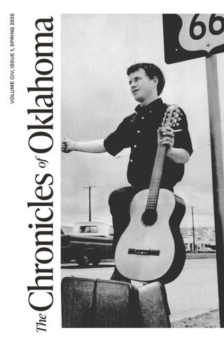
A young man hitchhikes on Route 66 outside of Warr Acres, 1967 (2012.201.B1251.0281, Oklahoma Publishing Company Photography Collection, OHS).
The Centennial of Route 66

By Trait Thompson*
In his seminal book, Route 66: The Mother Road, Michael Wallis wrote, “Route 66 expresses who we are, where we live, what we do, and whom we can become.” It is that sentiment of hope and adventure that has captured the imaginations of travelers from near and far for one hundred years. Despite the highway’s decommissioning over forty years ago, Route 66 continues to draw people to its small towns, and it beckons them to go a little farther to see what’s around the next bend. It’s for these reasons and many more that Oklahomans have been busy preparing for the Route 66 centennial for over five years.
I have the honor of being a member of two centennial commissions for the Mother Road. When I assumed my role as executive director
of the Oklahoma Historical Society (OHS) in 2021, I gained a seat on the Oklahoma Route 66 Centennial Commission. This commission is housed within the OHS and is chaired by Lt. Governor Matt Pinnell. We have a wonderful group of passionate Oklahomans from the public and private sectors who have dedicated a great deal of time to ensuring we are ready for the onslaught of travelers this year.
The first events sponsored by the Oklahoma Route 66 Centennial Commission will occur on May 30, 2026, in Tulsa and Oklahoma City. You can start your day in Tulsa witnessing the attempt to set the Guinness World Record for the largest classic car parade. We are attempting to get three-thousand classic cars (up to the 1996 model year) for this spectacular parade. Additionally, there will be lots of festivities including live music, food, and merchandise vendors. The cars will roll out at 8:00 a.m., but the fun will continue throughout the day at Expo Square.
The second May 30 event is the “Kickin’ It on Route 66 OKC Centennial Celebration” at Scissortail Park. Activities get started at 4:00 p.m. with the Oklahoma City Kids Market and the Route 66 Travel Hub. At 6:00 p.m., the live music starts. Oklahoma’s newest sensation in country music, Kaitlin Butts, headlines an evening filled with talent that includes Bailey Rae, OK3, and Ricochet. You’ll want to stay until the very end of the night because the festivities conclude with a jaw-dropping drone show.
Later this year, a Route 66 Awards Gala will take place in the fall and there will be another birthday celebration in Tulsa on November 11, 2026, the actual one hundredth birthday of the national highway system. As of this writing, the details of those events are still being finalized.
In 2023, I was nominated by Senate Minority Leader Mitch McConnell to serve on the US Route 66 Centennial Commission and formally appointed by President Joe Biden. I have served on the National and Local Events working group during my time on this commission. The national commission has a different mission than the state commission. Our role is to make recommendations to various federal agencies about projects or events they should undertake to commemorate the centennial. Over the past few years, we have endorsed hundreds of undertakings as official centennial projects. Along the way, we have
THE CHRONICLES OF OKLAHOMA
also worked with the US Postal Service to develop a series of special Route 66 stamps that will be released in May.
Last year, the US commission hosted the first Mother Road Summit in Albuquerque, New Mexico, to bring together Route 66 enthusiasts, tourism officials, preservationists, and business owners to plan for the long-term prosperity of the road. Based on the success of that event, the commission is hosting the second annual Mother Road Summit in Oklahoma City on April 23–24 at the Oklahoma History Center. This summit features an impressive array of speakers and topics. We will discuss transportation along the Route 66 corridor, new tourism opportunities, preservation resources, and much more. Additionally, there will be receptions at the National Cowboy and Western Heritage Museum and the El Reno Filling Station Visitor Center. The Turnpike Authority will also be conducting a ribbon-cutting at its recently completed improvement project at Oklahoma’s midpoint in Wellston.
Aside from the work the commissions are doing, the OHS has its own events and activities planned for the Route 66 centennial. Earlier this year, the Will Rogers Memorial Museum opened a fantastic

US 66 on Lincoln Boulevard from 26th Street to Bypass in Oklahoma City, 1958 (21160.0002618.65838.27, Oklahoma Department of Transportation Collection, OHS).
new exhibit about the Will Rogers Highway, available to view through January 2027. And speaking of new exhibits, our great staff at the Oklahoma History Center Museum in Oklahoma City is busy working on a new exhibit entitled The Longest Stretch: Route 66 in Oklahoma. This fantastic exhibit chronicling the history of Route 66 in Oklahoma will open on May 23, 2026, and be up for two years.
The new director of the Oklahoma Route 66 Museum in Clinton, Cory Cart, is planning several great events for the remainder of the year. On April 29, the popular morning television show Fox and Friends will be broadcasting live from the museum. On July 25, the biannual Route 66 Hall of Fame induction ceremony will occur, and a brandnew slate of inductees will be enshrined. Before the end of the year, the historic Glancy Motel neon sign will be restored and remounted on the grounds for the enjoyment of the thousands of visitors who come to the museum each year.
Dr. Bob Blackburn and I are also devoting all of the episodes of A Very OK Podcast this year to telling the great stories of the people and places that make Route 66 special. Each episode will have a fascinating guest or guests who help bring the subject matter to life.
Whether you are in Oklahoma or are miles away, I hope you will take time to learn more about the importance of the Mother Road to our state’s history. Better yet, set aside some time to get out on the open road and see some of this wonderful history for yourself. For more information on any of the events discussed in this article, visit www.okroute66.com.
THE CHRONICLES OF OKLAHOMA
Endnotes
* Trait Thompson is the executive director of the Oklahoma Historical Society and serves on two centennial commissions for Route 66.
The photograph on page four is the Route 66 centennial sign in Stroud, Oklahoma, taken by Trait Thompson.

Greatest Highway Project to Pass Through Oklahoma
Pawhuska Journal-Capital April 10, 1927 by
Lon Scott
Believing the time has come when America must be served by a great continuous highway to connect, like a railroad, the centers of population with a region capable of expansion by younger generations, the business men of America’s Great Southwest have formed an organization, “The U.S. 66 Highway Association,” to bring into being, at the earliest possible date, through Federal and state cooperation, America’s widest concrete thoroughfare. They propose to concrete the U.S. 66 Highway from Chicago, Illinois, to Los Angeles, California.
At a meeting, the second of its kind, of Chamber of Commerce, Automobile Club and State Highway Officials from pretty much all the way between Chicago and Los Angeles, to be help at the Kentwood-Arms
Avery Plaza, Tulsa, Oklahoma (photograph by Trait Thompson).
THE CHRONICLES OF OKLAHOMA
Hotel, in Springfield, Missouri, May 2nd, final estimates of costs for construction in each of the several states, as arrived at by the State Highway Departments, will be laid before the assembled members that a unified cooperative effort on the part of each state legislature and highway body may bring to completion by the end of 1928 an unbroken concrete slab from the Great Lakes to the Pacific.
Practically all of the route through Illinois and Missouri combined has been paved in the usual width. Strips of considerable distance are paved also in the other states. Every mile of highway has been maintained as an all-year-round road without any bad detours and with good passes over the lower Rockies since 1926.
Credit to Woodruff and Avery
Much of the honor for precipitating the public concern that brought about the U.S. 66 Highway Association goes to Cyrus S. Avery, of Tulsa, Oklahoma, and John T. Woodruff, of Springfield, MO., both of whom have had in recent years a deal to do with promoting good roads in the United States. Avery, former Chairman Oklahoma State Highway Commission and now Chairman of the Federal Highway Marking committee of the United States Department of Agriculture, looks upon the U.S. 66 Highway as the most important transcontinental road in America. For military reasons alone, he believes, it is absolutely necessary that U.S. 66 be paved all the way from Chicago to Los Angeles. Its importance as a highway can be proven in many ways, he claims, chief of which are the facts that U.S. 66 is shorter than any railroad and approximately 200 miles shorter than any other highway from Chicago to the Pacific coast.
Southwest Must Act
John T. Woodruff, president of the Association, foresees a great development, the result of completing at the earliest possible date a wide concrete highway, in the States of Oklahoma, Texas, New Mexico, Arizona, and California. Millions of people he points out, east of St. Louis and Chicago, with untold millions in wealth will, when they are provided with at least one modern concrete highway into the great Southwest, turn their attention to the largest commercially unexplored section of the United States.
By every token, he points out, the 66 route should be concentrated upon in the various states to the end of providing soon for its final
GREATEST HIGHWAY

Segment of a photograph showing US 66, 1978 (2012.201.B0261.0006, Oklahoma Publishing Company Photography Collection, OHS).

Route 66 sign, 1980 (2012.201. B1175.0076, Oklahoma Publishing Company Photography Collection, OHS).
THE CHRONICLES OF OKLAHOMA
completion as America’s widest strip of concrete road. No other route is so feasible of maintenance, no other route affords so much completed concrete now, no other route to the great centers of population of the central west and east affords the large cities of the southwest as good a highway as does U.S. 66. Woodruff claims, and of particular importance to the southwestern cities is the fact that U.S. 66 intersects every other cast and west Federal Highway besides transecting a good portion of the north and south roads.
Eastern Tourists Interested
Central Westerners and Easterners have these last few years been imbued with the idea of going south somewhere for winter vacations. Florida and the southeast coastal region beckoned them to come over wonderful highways. The building expansion that followed and is still following there in the wake of wealthy tourist traffic has repaid many times the coast of all highway expense.
To compete with the southeastern America the southwest states must provide the pressing need—an intersecting concrete highway— that will assure owners of fine cares and complete concrete highway through the vast southwest with good lateral state roads leading to the many resort regions on the Gulf and Pacific, Mr. Woodruff thinks, and he explains, with Illinois and Missouri already providing an almost continuous hard surface thoroughfare it is up to Oklahoma, Texas, New Mexico, Arizona, and California to close the gaps of dirt and dust that preclude the coming of the better tourists.
Route is Interesting
From Chicago the road traverses the rich agricultural and mineral regions of Illinois, on concrete or hard surface through the picturesque Ozarks to the lead and zinc region of Missouri, Kansas, and Oklahoma. The oil fields of both Oklahoma and the Texas Panhandle are along the route. In New Mexico the cattle-grazing plateaus are served by the highway and in Arizona it goes through the Bad Lands and close to the Grand Canyon coming to end over the lower Rockies in Los Angeles, California. In commerce, in agriculture, and in pleasure the proposed strip of concrete road would, lateral state roads taken into consideration, serve a total of thirteen states.
Paving Oklahoma Route 66: 1919–1937

By W. Edward Rolison and Carol Duncan*
In a July 26, 1926, letter to US Bureau of Public Roads official E. W. James, Tulsan Cyrus Avery wrote, “The only objective we, of Oklahoma, have had, was to have a continuous route number from Chicago to Los Angeles without any branches. We assure you that [US 66] will be a road through Oklahoma that the U. S. Government will be proud of.”1 Born in the mind of Cyrus Avery, Route 66 was not so much an infrastructure project as it was an idea—an idea whose time had come in 1926.
The notion that the United States needed, and should have, a national highway system had been around for about a decade when it was given Congressional support in the Federal Aid Road Act of 1916.
THE CHRONICLES OF OKLAHOMA
Prior to that, the development of the Lincoln Highway, extending 3,000 miles across the northern United States from New York to San Francisco, “predated Route 66 by more than a decade.” According to the National Park Service (NPS), “From 1912 until the end of the First World War, cross-country travel along the Lincoln Highway was largely limited to the wealthy few who could afford an automobile and dared to challenge the uneven, ill-defined course of the road. Route 66 opened the way for the masses to travel,” and it “was the result of America’s infatuation with rapid mobility, mass transportation, and technological change.”2
The 1916 law provided the groundwork for a national highway system to be publicly financed. Included in the law were provisions which (1) made any rural road eligible for federal aid if it was a “post-road” intended for delivery of the US mail; (2) provided for states to match federal funds fifty-fifty; (3) required the states to establish professional highway departments to be eligible for federal aid; (4) provided grants based on the region, population, and the number of post-road miles; (5) left the determination of primary routes to the states; and (6) provided for federal inspection of completed projects. Seventy-five million dollars were appropriated for a five-year period. This would be the equivalent of $2.252 billion in 2026. A similar appropriation was made in 1921 when the Congress passed the Federal Aid Highway Act, which continued the nation’s commitment to creating a coordinated network of interstate highways.3 Route 66 had its “official origin” with the passage of the Federal Aid Highway Act of 1921.4 However, as Susan Kelly pointed out, despite the formulation of the rules and appropriation of funds, “nothing much happened until 1924.”5 Congress had made a conscious decision to leave road paving choices to the states, so federal money was not ear-marked for the national thoroughfares.6
Cyrus Avery of Tulsa, Oklahoma, and John Woodruff of Springfield, Missouri, deserved the greatest credit for promoting the idea of an interregional link between Chicago and Los Angeles. However, their dreams could not be realized until they were merged with the national government’s decision in 1925 to implement its plans for a national highway system.7
Originally from Pennsylvania, Avery was fourteen when he came to Indian Territory from Missouri after his father went bankrupt in the Panic of 1873. He worked on his father’s farm, attended school, and


taught for three years to earn money to attend William Jewell College in Liberty, Missouri. After graduating in 1897, he married Essie McClelland and settled first in Oklahoma City, and then Vinita, where he engaged in insurance, real estate, and oil speculation. In 1907 he made his final move to Tulsa.8 “All his life,” according to Susan C. Kelly, “Cy Avery impressed people with his energy, his enthusiasm, and his willingness to take on projects he thought were important. Since his interests—oil, farmland, and real estate—necessitated traveling through the countryside,” Kelly continued, “it was no wonder that he became interested in road building.”9
In 1913 his friends elected him to the three-member Tulsa County Commission, where he became chairman and lobbied the state legislature for a law increasing the power of county commissioners to build roads. During a second term, Avery undertook serious roadbuilding, including the development of the first system of “split-log road-dragging” in Oklahoma. Kelly explained the process, based on a system invented in Missouri, as follows:
Left: Cyrus Avery, the father of Route 66 (reprinted from A Standard History of Oklahoma, Volume III, 1916).
Right: John T. Woodruff allied with Avery in promoting Route 66 (1998-518-1, Woodruff Collection, History Museum on the Square, Springfield, Missouri).
THE CHRONICLES OF OKLAHOMA
The drag was a horse- or mule-drawn device that, when pulled across a damp roadbed, dramatically improved the condition of the thoroughfare. . . . Essentially, the county paid to have a number of the split-log drags made and then had them delivered to farmers along the main roads. Farmers were then allowed one dollar a mile for dragging the roads after each rain. . . . By the end of Cy Avery’s second term, Tulsa County had 150 miles of roads that were dragged regularly and maintained by local farmers in such good condition that they were passable within twenty-four hours of a major rainstorm.10
Avery contracted a heavy case of “road fever,” and soon he became a leader in booster organizations, such as the Ozark Trails Association. In 1923, Governor Martin E. Trapp appointed him to be chairman of a new, three-member Oklahoma State Highway Commission. In this capacity, he created a system of state highways, provided for their maintenance, and laid out a statewide marking system. He also supported a 1924 state law that linked highway funds to a gasoline tax. Most importantly, as a member of the American Association of State Highway Officials (AASHO), Avery was crucial in determining the path and numbering of what became US Highway 66.11
A turning point was reached in mid-November of 1924 at the annual meeting of AASHO held in San Francisco. It was Avery’s first time attending the annual meeting, and he brought Chief Highway Engineer John Marshall Page and Bridge Engineer Walter Burnham with him. Because of his prior work in the Fort Worth office of the federal Bureau of Public Roads, Page knew almost everyone who was there. The Oklahomans joined with Frank Sheets of Illinois and B. H. Piepmeier of Missouri to form a contingent representing the Midwestern states. Among resolutions passed by the conference was one that called for uniform highway markings and warning signs. Another resolution asked Secretary of Agriculture Howard Gore to appoint a committee of state highway officials to organize a national highway system by linking together already existing federal aid roads.12 These resolutions led to the appointment of a joint board of federal Bureau of Public Roads officers and twenty-one state highway officials nominated by AASHO with the mission of creating a new system of interstate highways and

Governor Martin E. Trapp, c. 1925 (6312, Oklahoma Historical Society Photograph Collection, OHS).
developing a uniform marking system. Avery, along with Piepmeier, was on the list to represent the eleven states of the Mississippi Valley, which positioned him to influence the designation and numbering of the federal highways.13
Avery’s objective was to designate and number a federal highway from Chicago to Los Angeles through Tulsa. This he accomplished with US Highway 60. He also managed to bring six additional national highways through Oklahoma, including three through Tulsa. The joint board finished its work and presented its plan to the Secretary of Agriculture in October 1925. The board was dissolved, but Avery was fortunate to be appointed to the Executive Committee of AASHO at the annual meeting held in Detroit in November. The Executive Committee was charged with deciding on any changes or additions to the plan; thus, when the number assigned to the Chicago to Los Angeles road became an object of controversy, Avery was in a position of influence.14
There was much discussion over which number to assign “Avery’s road,” with much support for calling it US 60. That number was assigned to the road with Avery’s support, and Piepmeier went so far as to print highway maps with that number. However, Kentucky Governor
THE CHRONICLES OF OKLAHOMA
William M. Fields vigorously objected. He wanted that number for a road from Springfield, Missouri, through Kentucky to Newport News, Virginia, on the East Coast. He felt insulted that his highway had been assigned US 62, a number Avery also found unacceptable for his road.15 The perception was that any number that did not end in zero was less prestigious. A stalemate ensued until Avery finally called a meeting in Springfield, Missouri, on April 30, 1926, in which Page suggested US 66 because it had not yet been assigned.16 Avery had hired Page from the Bureau of Public Roads office in Fort Worth at a yearly salary of $5,000 because he was familiar with Oklahoma's road conditions, and knew many of the people involved.17
That afternoon, Avery and Piepmeier sent a telegram to the Bureau of Public Roads in Washington, DC, stating that if the other states would “accept sixty six instead of sixty we are inclined to agree to this change. We prefer sixty six to sixty two.”18 A month later, Piepmeier was so exasperated that he declared in a letter to Avery on May 28 that he would “accept 62, 66 or 60, from Chicago to Los Angeles, and nothing else. They can number the road from Springfield to Newport News anything they choose. That is my position and I hope you will agree with me and that we can get something settled at once.”19 Avery did agree and informed the Bureau of Public Roads. On July 23, the Bureau notified Avery that Kentucky had agreed that the Springfield to Newport News route would be US 60 and the road from Chicago to Los Angeles would be designated US 66.20
With the roadblock broken, the Executive Committee of the AASHO adopted the numbering scheme for all federal highways, including US 66, on November 11, 1926. However, this was subject to approval by the individual states to make the new federal routes part of their state systems. In Oklahoma, approval came on December 7, 1926. According to author Jim Ross, “The pathway chosen for 66—state roads 39, 7, and 3—roughly followed one branch of the former Ozark Trails (in eastern Oklahoma) as well as the railroad, and in places overlapped the existing Postal Route [west of Oklahoma City]. At the time, these state highways were mostly unimproved, especially in rural areas, so it became a priority for all concerned to get Route 66 paved, border to border.”21
Crucial to the promotion of the road was that, as soon as the decision to develop US 66 was made, Cyrus Avery began to plan the founding of the US Highway 66 Association. Joining Woodruff, he arranged

B. H. Piepmeier (photograph courtesy of the National Park Service).

Telegraph from Avery and Piepmeier to the Bureau of Public Roads which officially accepted 66 as the number for the new highway, 1926 (courtesy of the National Park Service).
THE CHRONICLES OF OKLAHOMA
invitations from the Tulsa and Springfield Chambers of Commerce for a meeting to be held in Tulsa on February 4, 1927. Five of the eight states sent delegations along with a contingent from Arkansas that supported a national road to its north and west. Illinois did not attend because most of its portion of the road was paved, and delegates from California and Arizona may have been concerned about the distance. The purpose was two-fold: to expedite the paving of the road and to publicize it. Avery was not only the keynote speaker; he dominated the sessions and was the object of a resolution of appreciation for his work on 66 and the federal highway system. In a grand gesture, he pulled a five-dollar bill from his pocket and declared that he would be the first member of the National Highway 66 Association. He also recommended that Highway 66 “be called The Main Street of America, a name that was to appear on brochures, maps, postcards, and in travel guidebooks for the next half-century. The only thing Avery did not do,” according to Susan Kelly, “was to get himself elected president of the 66 Association. Oklahoma politics and a new governor [Henry S. Johnston] who was not a strong backer of the highway commission chairman probably influenced Avery’s move to nominate John Woodruff instead. Elected by acclamation,” continued Kelly, “Woodruff retained his office for two terms and then was succeeded by the father of Route 66.”22 Route 66 would become an essential and iconic part of the national system. However, it would not be built from the ground up; rather, it would be pieced together from a disparate complex of existing roads and promises of roads extending across half of the country. Some were established roads and city streets that were already paved; others were country roads that were graveled, barely graded, or simply rutted and dusty dirt paths. Simply put, US 66 was a designation given to existing roads and the promise of roads along the route. The new number, 66, replaced old numbers or names, such as the Ozark Trails. At the beginning, Illinois and Missouri had the most pavement, with California second. Further west one encountered states that had entered the Union relatively recently: Oklahoma in November 1907, New Mexico in January 1912, and Arizona in February 1912. While the federal government provided highway matching funds, the actual work of paving, bridge construction, and maintenance was left to the state governments. The NPS described the road situation in Oklahoma at the birth of Route 66 as follows:
20
US Highway 66 in Oklahoma occupies a very special place along the great arc of the Mother Road. Here the densely populated and nuanced terrain of the Midwest meets the western road’s wide open plains country.
At the creation of Route 66 in 1926, Oklahoma was hardly twenty years into statehood, and it was still developing a modern infrastructure. As late as 1926, Oklahoma had more railroad mileage than highway miles. Fewer than 12% of the State’s roads had hard paved surfaces. As a result, the first generation of Route 66 roadbed in Oklahoma was a patchwork of disparate and often primitive roads.23
From its eastern end, Route 66 began at Grant Park in downtown Chicago and meandered across Illinois to St. Louis, Missouri, where it crossed that state through Rolla, Springfield, and Carthage to the Kansas state line about twelve miles west of Joplin, Missouri. Kansas hosted the thoroughfare for a mere thirteen miles before it left Baxter Springs, and crossed into Oklahoma near Quapaw about eight miles northeast of Miami, Oklahoma. Zigzagging its way through northeastern Oklahoma, often along township and county section lines, it extended from Vinita, through Catoosa and Tulsa, through Sapulpa and Bristow, Stroud and Chandler and past the Round Barn at Arcadia; it then dipped into Oklahoma City from the north, exiting through Bethany and Yukon and made a crooked line from El Reno through Calumet and Geary. From there, it crossed the South Canadian River at Bridgeport and then made a beeline to the Texas border through Weatherford, Clinton, Elk City, and Sayre, crossing into Texas at Texola, about seven miles west of Erick.
From its western end, US 66 began first in downtown Los Angeles, and later in Santa Monica, California; then it went to San Bernadino where it turned north to cross the Mojavi Desert through Barstow, Amboy, and Needles, California, where it crossed the Arizona line. In Arizona, the route went through Oatman and Kingsman, Seligman, Flagstaff, Winslow, and Holbrook, leaving the state at Lupton. In New Mexico, it was Gallop and Albuquerque with a dip south to Los Lumas and a swing north to Santa Fe, then south to Santa Rosa and east to
THE CHRONICLES OF OKLAHOMA

Tucumcari. Crossing the Texas line at Glenrio, it traversed the high plains country of the Texas Panhandle through Amarillo, McLean, and Shamrock, which was fourteen miles west of the Oklahoma state line: approximately 2,440 miles, crossing through parts of eight states.
The thirteen miles of US 66 in Kansas were paved with concrete almost as soon as the route was determined, but, “in Oklahoma, where 66 was born, paving—like almost everything else—became a political issue, took longer, and received a lot more public attention.”24 According to Susan Kelly, “In 1929 a Texaco road report on U. S. 66 gave notice that Illinois and Kansas were concreted, that Missouri was two-thirds paved, and that Oklahoma was one-fourth paved. In Texas, Route 66 had yet to see a cement mixer, and only 64.1 miles of pavement had been poured anywhere on the westernmost 1,221 miles of the highway that stretched across New Mexico, Arizona, and California.”25 Most of these miles were in California. Progress was affected not only by funding, which was on a fifty-fifty matching basis for federal grants, but also by technical knowledge and politics, which often determined priorities.26
Portion of a US highway map showing Highway 66 as Highway 60 as it cut across Oklahoma, 1926 (11757.000, David Rumsey Map Collection, David Rumsey Map Center, Stanford Libraries).
In 1919 the Western Pavement Company and M. A. Swatek laid the first pavement for US 66 in Oklahoma. This section was a macadam surface of 0.189 miles, and the second a Topeka asphalt surface on a macadam base of 0.500 miles placed from the Frisco railway tracks east on 23rd Street past the Oklahoma State Capitol in Oklahoma City. The next significant paving project did not take place until 1922 when the Western Pavement Company laid a 15.469-mile stretch of concrete base, rock asphalt surface from Miami to Afton in Ottawa County. The year 1922 also saw about eleven miles of concrete paving in and around Tulsa. Six-and-a-half miles of concrete were laid in Oklahoma County in 1923. In 1924 Creek County received almost ten miles of concrete paving in various locations. Likewise, Creek County received about ten miles of concrete in 1925.27 These early projects amounted to about fifty-five miles of pavement and about twenty miles of pavement was added during 1926.28 Thus, at the time of the designation of US 66 in late 1926, there were approximately seventy-five miles of pavement on the route, not including bridges. Almost all of this was east of Oklahoma County. The next four years saw an increase of eighty miles of pavement in the east and forty-five miles in the west.29
Sam Hawks took charge of the State Highway Commission in 1931, and the pavement of Route 66 took off. During that single year, as many miles of the route were paved as had been during the previous fouryears. In 1931, there were about seventy-five miles in western Oklahoma and only fifty-four miles in the east.30 Some of these projects had been authorized by the previous commission, chaired by Lew Wentz, who continued to be a member. On February 1, 1931, Hawks promised that “we are going to let contracts as fast as the engineering department is ready for them. There are funds available from the federal government which must be spent by September, and the commission will carry out the program.”31 Keeping his promise on February 24, Hawks let contracts for sixty miles of paving for US 66 through Canadian, Blaine, Caddo, Custer, Washita, and Beckham Counties.32 On May 14, 1931, it was reported that “Highway Sixty-six will be paved from El Reno to the Texas line this year. . . . [T]he contract for 34 miles of paving from Clinton to Bridgeport will be let just as soon as the awards can be made. . . . Contracts have been let on Sixty-six between Clinton and Elk City and paving is going forward on that section of the highway. A strip from Erick west to the Texas line is also under construction at this time.”
THE CHRONICLES OF OKLAHOMA

The road between Clinton and Elk City, c. 1908 (20921.2, Oklahoma Historical Society Photograph Collection, OHS).

The road leading into Clinton, 1936 (2012.201.B0260.0677, Oklahoma Publishing Company Photography Collection, OHS).

Hawks was quoted as saying, “We intend to make the completion of Highway 66 the outstanding accomplishment of the road board for this year, and the people of western Oklahoma will find there is a Santa Claus after all.”33 Also in May, contracts would be drawn up to finish the last miles of pavement between Oklahoma City and the Texas border, although several stretches on the eastern side of the state were not paved for another six years, primarily due to politics. Plans were announced to complete the paving of US 66 to the Kansas border as soon as the county commissioners of Craig County provided matching funds for a nineteen-mile gap in the road in that county.34 However, The Daily Oklahoman pointed out that two of the three Craig County commissioners were “strenuously” opposed to the investment of the county funds.35 It would be years before that stretch of US 66 was finished.
The high-water mark for Hawks’ career as a highway commissioner was 1932, despite a suspension of federal highway funds that lasted from March to December 1932. In January 1933, the Commission released its Biennial Report to the governor for the years 1931-32. According to the Elk City Journal, the Report showed that during 1932 the Highway Commission “brought to grade and drainage a total of 1,004
Sam Hawks (photograph courtesy of the Carl Albert Congressional Research and Studies Center, University of Oklahoma, Norman, Oklahoma).
THE CHRONICLES OF OKLAHOMA
miles of the State’s Highway system,” which was “more than twice the mileage drained and graded in any other year in the department’s history.”36 This was 626 more miles than were drained and graded in 1931, 591 more than in 1930, and 585 more than in 1929. The Report also showed that the Commission had constructed or had under contract a total of 208 miles of high type surfacing. Most significantly, the cost of construction had been reduced by more than $4,000 per mile, which was the greatest reduction made in slab cost by any southwestern state. Also, 368 bridges were constructed in 1932, which was 241 more than in 1931, 248 more than in 1930, and 222 more than in 1929.37
In 1931, Hawks was voted Clinton’s “Outstanding Citizen,” largely in recognition of his getting western Oklahoma “out of the mud” through the construction of secondary roads.38 Hawks was focused on secondary and farm-to-market roads, but he appreciated the need to finish the major thoroughfares as well, especially Route 66. In 1932 not quite fifteen miles were paved in the east while in the west the total was almost twelve miles.39 Hawks was out of office in March 1933. Before he left, orders were let for the paving of thirty miles of US 66 in the east, and two and a half in the west. For the most part, this finished the paving of Route 66 through Oklahoma; the only stretch left was around thirteen miles in Craig and Ottawa Counties, i.e., the “sidewalk highway” between Miami and Afton. These miles were finally brought up to standard in 1937.40
Before 1923, standards varied greatly as to width of roadways and rights-of-way. The “sidewalk highway” between Miami and Afton was one of the more unique stretches of pavement, not only in Oklahoma, but on the whole highway. Constructed between 1919 and 1922 by the Oklahoma Highway Department as part of SH 7, it was only nine feet wide with five-foot, gravel shoulders. Apparently, since funds were limited, it was decided that one lane that covered the full distance was better than two lanes that went only halfway.41 Jim Ross described the road as follows:
Though narrow, the “sidewalk” highway was well constructed. Following the same specifications as some of its wider counterparts, it consisted of concrete five inches thick with nine inchwide [sic] edges elevated an additional two inches. Asphalt was then added, bringing the surface flush with the concrete edges. Given the traffic count and speed of cars in 1922, such a narrow
highway was not considered unusual. By the mid-1930s, however, the needs of the motoring public had changed dramatically, and this classic strip of America’s Main Street was bypassed by the current alignment.42
In 1924 standard rights-of-way were set at sixty-six feet although the widths of the driving surfaces continued to vary. The roadway widths were set at eighteen feet and rights-ofway expanded to eighty feet in 1925. By 1930 minimum roadway widths had increased to twenty feet with rights-of-way set at 100 feet.43 This bypass did not happen until 1937, and it became the last stretch of Oklahoma Route 66 to be brought to standard.
Another bypass that created much public comment while Hawks was commission chairman was an eighteen-mile segment of Portland Concrete between El Reno and Bridgeport called “the El Reno cutoff.” Begun by the state with federal aid in 1930, it was “a straightening, shortening and paving project” that, when completed in 1934, “created a more direct alignment of Route 66 between El Reno and Hydro, eliminating an original dirt route that jogged north through the towns of Calumet, Geary, and Bridgeport. The new alignment in response to the ever-growing traffic along Route 66 hurt these bypassed towns. Bridgeport became [largely] a ghost town [although people still live there today].” Some Bridgeport businesses moved out to the 1933 alignment. “The new alignment’s construction standards,” continued

The "sidewalk" highway, 2008 (photograph provided by Abraham Ezekowitz).
THE CHRONICLES OF OKLAHOMA

Road grader, c. 1920s (photograph provided by the Oklahoma Department of Transportation.). Concrete paved lanes, c. 1920s (photograph provided by the Oklahoma Department of Transportation.).


the NPS, demonstrated “the progressive adjustment of road design to increased traffic volume: the roadbed’s width adhered to the 1930s standard of twenty feet over the previous decade’s eighteen-foot allowance. The new roadbed also boasted a system to facilitate drainage in rainy weather, which included a parabolic crown, lip curbs, and gutters. This same project also replaced a private toll bridge, the Key Bridge at Bridgeport, with the public William H. Murray Bridge, which spanned the [S]outh Canadian River along the new alignment.”44 Until it was purchased by the state and made free, the Key Bridge charged rather steep tolls of $1.00 for each ordinary vehicle, and $1.50 for trucks. One dollar in 1926 would be equal to $18.46 in 2026 currency.45
While Portland Concrete was the preferred type of pavement with asphalt over a concrete base being second, it was also the most expensive. Consequently, a variety of surfaces were used depending on funds, expected traffic conditions, subgrade soil conditions, and availability of materials. Early surfaces ranged from graded dirt, gravel (also known as Traffic Bound Surface Course (TBSC), oiled gravel, brick, macadam, asphalt (including rock, sheet, and single bituminous), asphalt over a concrete base with concrete edges, to Portland Concrete.46 One stretch of Route 66 on the California/Arizona border was even paved with wooden planks.47 This method was apparently never used in Oklahoma.
Tractor breaking ground for Route 66, c. 1920s (photograph provided by the Oklahoma Department of Transportation.).
THE CHRONICLES OF OKLAHOMA
As time went on, more attention was paid to safety. Unnecessary railway crossings, sharp turns, and short curves were eliminated, and center lining, marking of hills and curves, and proper signage helped protect motorists from themselves. In recent years there have been some comments concerning the safety of using sloping curbs on the original Portland Concrete stretches, especially in western Oklahoma. These curbs, which can still be seen today and are considered a characteristic feature of “Old 66,” were designed to keep water on the pavement until it could be expelled into gutters and to keep tires from slipping onto soft shoulders, causing erosion. The curbs accomplished their mission, but they also created a hazard for motorists who could lose control by unexpectedly bumping against them. They also increased the possibility that autos could hydroplane in wet weather.48
The construction of US 66 became more standardized over time. Pavement was laid in two lanes, each nine feet wide and six-to-ten inches thick, depending on the subgrade. Specifications changed over the years as the engineers learned what did not work. For example, in the beginning, the middle of the slabs were thicker than the edges, until experience proved that heavy trucks caused the edges to break and crack. Even though their value had been demonstrated years before in England, soil studies were not done on a regular basis until after 1930, an improvement apparently made on Hawks’ watch.49
Much of the early romance surrounding Route 66 came as a result of John Steinbeck’s classic novel, The Grapes of Wrath, in which he told the story of the fictional Joad family’s journey on Route 66 from Depression-era Oklahoma to what they expected to be a better future in California.50 The novel, subsequent movie, and a musical version written by Oklahoma vagabond Woody Guthrie seared into the public mind a view of Route 66 forever associated with the migration of tenant farmers to California. Indeed, it was true that US 66 provided a pathway to the west for thousands of destitute “dust-bowl refugees” from Oklahoma. A less recognized impact of Route 66 was its importance in providing a reason for many more Oklahomans to remain in Oklahoma. Susan Kelly pointed out, “Route 66 gave them jobs. To the more innovative, the highway brought customers for a variety of enterprises, from Indian craft shops to cafes, motels, and service stations. To others, the road’s own need to be paved and the federal
government’s willingness to use that need as a conduit for relief action provided enough work and income to last through the hard times.”51
Route 66 was “methodically dismantled and reconfigured” in the 1960s. As Jim Ross stated, “Many sections were either abandoned or consumed by the super slab (i. e., the Interstate Highway System), while others became access roads or were turned over to local jurisdictions to do with as they saw fit. Towns were bypassed and long stretches of road became isolated. By the mid-1970s, America’s Main Street had all but vanished, and in 1985, the last of the signs came down when it was officially decertified as a federal route. Some states chose to redesignate parts of it as a state highway; otherwise, Route 66 disappeared from road maps completely.”52
Route 66 in Oklahoma offered “a good example of how a road and its environment can be mutually sustaining. With the improvement of the roadbeds and the increase in local and interstate traffic, new commercial activity sprouted up along the Oklahoma roadside. These interconnected developments exposed many of the State’s isolated rural communities to a broader range of social, cultural, and economic contacts. In a sense both Oklahoma and Route 66 grew together.”53 However, according to the NPS, “The story of U. S. Highway 66 in Oklahoma is not exclusively a tale of uplift and progress . . . . While many roadside communities flourished, others suffered when they lost the highway in one of its periodic realignments. For some, moreover, the coming of an exciting, wider world via Route 66 proved an unwanted experience. In addition,” they continued, “the trek of Dust Bowl migrants along the Mother Road during the 1930s continues to invoke vivid images and memories of human suffering. The postwar boom in tourism and transport catapulted Route 66 into its Golden Age but also nudged it closer to extinction, as Oklahoma opted to replace the eventually overburdened highway with a new generation of multi-lane, limited access thoroughfares.”54 In time, Oklahoma City was connected to Joplin, Missouri, through Tulsa, by the Turner and Will Rogers Turnpikes, and, after 1970, to the Texas border by Interstate 40; Route 66 found itself relegated to servicing local traffic.
THE CHRONICLES OF OKLAHOMA
Endnotes
* W. Edward Rolison, PhD, is professor emeritus and former head of the Department of the Social Sciences at Southwestern Oklahoma State University at Weatherford. The late Carol Duncan was a well-known local historian and researcher of topics related to the city of Clinton, Custer County, western Oklahoma, and Route 66. Material for this article was drawn from their book, Route 66 and the Story of Sam Hawks: Pioneer, Entrepreneur, Politician (Oklahoma Hall of Fame Publishing, 2025).
The photograph on page thirteen shows US 66 just north of the Capitol in Oklahoma City, 1936 (2012.201.B0260.0681, Oklahoma Publishing Company Photography Collection, OHS).
¹ Jim Ross, Oklahoma Route 66 (Ghost Town Press, 2001), 19.
2 United States Department of the Interior, National Park Service, “Discover Our Shared Heritage Travel Itinerary: Route 66,” https://www.nps.gov/nr/travel/route66/ text-only.html, 3, accessed August 10, 2021. Hereafter cited as NPS, “Route 66.”
3 Quinta Scott and Susan Croce Kelly, Route 66: The Highway and Its People (University of Oklahoma Press, 1988), 8–9. Also, Eliasen, “Currency Conversions.”
4 NPS, “Route 66,” 3.
5 Scott and Kelly, Route 66, 9.
6 Scott and Kelly, Route 66, 18.
7 NPS, “Route 66,” 4.
8 Scott and Kelly, Route 66, 9.
9 Scott and Kelly, Route 66, 10.
10 Scott and Kelly, Route 66, 10–11.
11 Scott and Kelly, Route 66, 11–13.
12 Susan Croce Kelly, Father of Route 66: The Story of Cy Avery (University of Oklahoma Press, 2014), 131-32.
13 Kelly, Father of Route 66: The Story of Cy Avery, 135
14 Kelly, Father of Route 66, 152–53.
15 Ross, Oklahoma Route 66, 2–3.
16 Ross, Oklahoma Route 66, 3.
17 Kelly, Father of Route 66, 119.
18 Ross, Oklahoma Route 66, 3.
19 Scott and Kelly, Route 66, 15, 17.
20 Scott and Kelly, Route 66, 17.
21 Ross, Oklahoma Route 66, 1.
22 Scott and Kelly, Route 66, 24.
23 NPS, “Route 66,” 39.
24 Scott and Kelly, Route 66, 27.
25 Scott and Kelly, Route 66, 22.
26 Scott and Kelly, Route 66, 22.
27 Oklahoma Department of Transportation, “Construction History of Route 66,” https://www.odot.org/memorial/route66/route66const-hist.htm), 1, accessed August 9, 2021. Hereafter cited as ODOT, “Construction History.”
28 ODOT, “Construction History,” 2.
29 ODOT, “Construction History,” 2–5.
30 ODOT, “Construction History,” 5–6.
31 “Highway Commission to Go Ahead with Road Contract Awards, Delay Cement Bids,” The Daily Oklahoman, February 1, 1931, 1.
32 “Sixty-Six To Get Sixty Miles of Hard Surface Roads Soon,” Clinton (OK) Tribune, February 12, 1931, 1.
33 “Sixty-Six To Be Paved Across State This Year,” Clinton (OK) Tribune, 1.
34 “Sixty-Six To Be Paved Across State This Year,” Clinton (OK) Tribune, 1.
35 “Craig County Citizens Rise to Force Paving of Gap,” The Daily Oklahoman, May 25, 1931, 1.
36 “Record Year Shown to be Greatest in Highway Report,” Elk City (OK) Journal, January 5, 1933, 1. See also, State of Oklahoma, State Highway Department, Report of the State Highway Commission for the Years 1931 to 1932 Inclusive (Oklahoma Department of Highways, 1932). Cited hereafter as 1931–32 Biennial Report
37 1931–32 Biennial Report
38 “Sam Hawks even stood up to oil barons for 66,” Clinton (OK) Daily News, May 25, 2012, 6B.
39 ODOT, “Construction History,” 6–7.
40 ODOT, “Construction History,” 7–8.
41 NPS, Route 66, 40.
42 Ross, Oklahoma Route 66, 27–28..
43 Ross, Oklahoma Route 66, 11.
44 NPS, “Route 66,” 40–41.
45 Joe Sonderman and Jim Ross, Images of America: Route 66 in Oklahoma (Arcadia Publishing, 2011), 7. Also, Alan Eliasen, "Curresey Conversions."
46 Ross, Oklahoma Route 66, 10.
47 Scott and Kelly, Route 66, 21.
48 Ross, Oklahoma Route 66, 12–13.
49 Scott and Kelly, Route 66, 22–23.
50 John Steinbeck, The Grapes of Wrath (The Viking Press, 1939).
51 Scott and Kelly, Route 66, 28, 59.
52 Ross, Oklahoma Route 66, 6–7.
53 NPS, “Route 66,” 39.
54 NPS, “Route 66,” 39.
THE CHRONICLES OF OKLAHOMA

Woody Guthrie, n.d. (2010.011. B139.0391, Oklahoma Journal Photography Collection, OHS).

Will Rogers Highway sign, 1952 (2012.201.B0260.0683, Oklahoma Publishing Company Photography Collection, OHS).
Will Rogers Highway Words and Music by Woody Guthrie
This big highway goes from coast to coast, From New Yorker town down to Los Angeles; It’s named for Willy Rogers that went on this road From New Yorker town down to Los Angeles.
My Sixty-Six highway, this Will Rogers road, It’s lined with jalopies just as far as I can see; Can you think up a joke, Will, for all o’these folks From New Yorker town down to Lost Angeles?
Ten thousand lost families I count every day Caught under my bridges and under my trees; Can you make up a joke that’ll win them a job From New Yorker town down to Lost Angeles?
I love Willy Rogers, I love your big smile, I go to my showhouse, Will Rogers to see; Can you grin up a tale that’ll feed my folks stranded ‘Twist New Yorker town and Lost Angeles?
This Will Rogers highroad I hitched lots o’times; All day long you sizzle; all night long I freeze; Did ye tickle Hoover enuf ta build us all houses From New Yorker town down to Lost Angeles?
Willy Rogers got born down around Oolagah, In my great Indian nation of the Cherokee; My Indians all call this the Hungry Gut Highway From New Yorker town down to Lost Angeles.
I bummed this good road with folks you call Goons, And your high families called us the lost refugees; You hafta go back, Will, and tickle ‘em again From New Yorker town down to Lost Angeles.
The Preservation of the Threatt Filling Station

By Lynda Ozan*
Put aside for a moment the centennial celebrations of Route 66. Put aside the remarkable architectural details of the Threatt Filling Station.1 What remains is the history of a family whose story embodies resiliency, entrepreneurship, and African American heritage along Route 66—in Oklahoma County, in Oklahoma, and across the entire length of the highway. Preservation in this context extends beyond the conservation of sandstone walls and rooflines; it encompasses the lived experiences, memory, and stewardship of the Threatt family. Their continuity of presence transforms the station from a static relic into a
dynamic heritage space, where identity, community, and cultural resilience converge. In this way, the Threatt Filling Station is not merely a historic structure but a living testament to the African American role in shaping the landscape of American mobility and commerce.
The story of the Threatt family in Oklahoma begins with the union of Newton and Vicie Threatt in 1897 in Harpersville, Shelby County, Alabama.² From this marriage came six children: Allen, Thomas, John, Frank, Emma, and Frances, who were raised on the family farm in Alabama. In October 1907, son Allen married Alberta Wallace, marking the start of a new chapter in the family’s history. In August 1918, Allen filed his World War I registration in Luther, Oklahoma, the first documented record of his presence in the state. By the time of the 1920 Federal Census, Allen and Alberta were recorded as renting a farm in Wellston, Lincoln County, Oklahoma, and with that, the legacy of the Threatt family in Oklahoma begins—a legacy that would eventually be anchored by the construction of the Threatt Filling Station, a landmark of both African American enterprise and Route 66 heritage.
Following the Land Run of 1889, the Threatt property (Section 25, Township 14N, Range 1E), along with many surrounding sections, was designated as “School Land.”3 These lands remained under school district control until they were deemed no longer necessary. Over time, Section 25 was leased by various individuals before ultimately being purchased by the Threatt family in 1920. Allen and Alberta Threatt arrived in Oklahoma around 1918, part of a wave of Black migration from Alabama to the Luther area that began in 1917. The communities of Luther, Luther Township, and nearby Arcadia developed a significant African American population. Unlike Oklahoma’s historic All-Black towns, Luther’s growth was not the result of formal organization but rather of family-based migration patterns. This relocation from Alabama to Oklahoma reflects broader patterns of African American mobility in the early twentieth century, as families sought new opportunities in farming, land ownership, and entrepreneurship.
On a high point, overlooking the property, Allen built a sandstone house for his large family with eleven children.4 He maintained a working farm where he raised crops for profit. After two years of proving up, the Threatts received a warranty deed for their quarter section, and eight years later, it was recorded. Accounts from newspapers detail a thriving farm: six horses, two cows5 a thirteen-month-old Jersey
THE CHRONICLES OF OKLAHOMA

bull calf purchased for developing their home dairy,6 and sales of cotton, corn, and peanuts. Based on the 1930 census, Allen Threatt owned his own farm and land valued at $4,000, and Alberta managed the home—full with ten children (at the time). Threatt knew that it would take more to sustain a family; he was producing income from a farm and laying the groundwork for other successful enterprises. Everything changed when the Great Depression began in 1930 as a drought hit the region. The Threatts were not immune to the devastation. Rural Oklahomans, who numbered 1,500,000, saw farm income fall 64% in the 1930s. Newspaper notices across the state indicate that farmers were falling behind in paying personal taxes. In Luther, several Black families lost all or part of their holdings, including their homes and farms. With the decline in crop prices and still having to pay a mortgage on the farm, the Threatt family had to focus on other
R.M. Hughes, Portion of plat map showing the Threatt property, 1960 (Joe Pitts, U.S. Land Patents Homesteads, Oklahoma County, Indian Territory Land Run of April 22, 1889).
THREATT FILLING STATION


The Threat Family (photograph provided by Threatt family).
The Threat Family (photograph provided by Threatt family).
THE CHRONICLES OF OKLAHOMA
sources of income, including the rock quarry that would later supply the materials for the filling station. Threatt, strong and confident to move his family from Alabama to Oklahoma for a better life, did not stand still for long.
Transportation facilities in Oklahoma began to form two decades after statehood. In the early years, rural roads followed section lines that were maintained by the county commissioners. The traveling public had to zigzag across section lines to reach their final destination as no direct routes existed. As school districts began to consolidate, requiring moving children from rural farm communities to “local” schools, roads and transportation systems needed improving. Due to the Good Roads Movement, the Oklahoma State Highway Department was created in 1907 and began to function in 1911. By 1914, the newly planned state highway system proposed 2,400 miles of roadways. Maintenance of these systems was still under the control of the county and local city governments. Auto trails bearing names like the Albert Pike Highway, Ozark Trails, Meridian Highway, and the King of Trails were marked across the state and guided motorists from place to place. Some were regional trails while others were links to resorts or other popular travel destinations.
During the 1924 legislative session, Oklahoma lawmakers passed a bill creating the first highway system. The road defining the north end of the Threatt property was designated State Highway 7. By 1925, traffic demands on Oklahoma’s highways were ahead of the road development.8 A national system of interstate highways was being developed by the Federal Bureau of Public Roads and the American Association of State Highway Officials and that same year, they selected State Highway 7 as part of a yet-to-be-determined national route.9
In 1925, Oklahoma’s Highway System totaled 5,156 miles, of which only 374 were paved. During the next fifteen years, the system grew to 8,782 miles with 5,116 being hard surfaced. Of the highways crossing Oklahoma, US 66 became the single most important artery for traffic across the nation.10
On December 7, 1926, the Oklahoma State Highway Commission formally approved the newly established US Highway System, adopted less than a month earlier by the American Association of State Highway Officials (AASHO). This action officially incorporated the federal routes into Oklahoma’s state highway network. Among these routes
was US 66, which traversed the state from the Kansas border in the northeast to the Texas border in the west.
At the time, few roads in Oklahoma were paved, and bringing US 66—later known as Route 66—to a uniform standard required nearly a decade of work. Construction progressed incrementally as federal funding became available, and the highway represented state-of-theart road-building technology of the era. While paving materials and designs varied, Portland cement concrete was the predominant surface used across Oklahoma. Asphalt was employed less frequently, and brick paving remained in place along certain sections, such as between Edmond and Arcadia.
As Route 66 crossed from Lincoln County into Oklahoma County, it intersected the northern boundary of the Threatt property. Elizabeth Threatt recalled that Allen and Ulysses11 contributed to the highway’s construction at this location. Each day, they hauled concrete, poured it in place, and used a fresno to finish the surface. The following day, they advanced to the adjacent section and repeated the process, steadily progressing along the route. The section in front of the Threatt property was completed in July of 1930.12

Ulysses Threat, c. 1940s (photograph provided by Threatt family).
THE CHRONICLES OF OKLAHOMA
Three years later, the Oklahoma State Highway Commission restarted a stalled federal aid project to finish the unfinished portions near Wellston in Lincoln County. Completing this portion of the road, which straightened and shortened the route, improved traffic flow and made the route passing north of the Threatt property attractive to cross-country motorists. Observing the progressive enhancement of his property, Allen discerned its latent economic and social potential, recognizing both the land’s intrinsic worth and its prospective utility to itinerant travelers; consequently, the conceptual foundations of his enterprise began to crystallize. Despite the fear of “not knowing what was around the next corner,” owning a car gave the Black traveler a sense of freedom—freedom from segregated buses and trains, freedom from segregated depots—but that came at a cost. Where was the Black traveler to stop for services? Gas stations generally provided gas regardless of race, but restroom facilities were often “whites only.” Food and lodging were also racially divided.
Many towns in Oklahoma passed notorious sundown ordinances prohibiting Blacks from merely spending the night in those communities. Some communities in Oklahoma went so far as to “kindly request” Black travelers not be in the community after sundown. The Negro Motorist Green Book, which started in 1936, consisted of a list of businesses that catered to the Black traveler. Because the book highlighted larger cities, places in Oklahoma City and Tulsa are included. Rural areas, such as the Threatt Filling Station, were not included. The Threatt Filling Station advertisement came by word of mouth.
The exact date of construction of the Threatt Filling Station is unknown. A date of “MARC 22, 1933” is etched into the foundation at the southeast corner of the present-day building. A 1936 article in the Luther Herald indicated the extant nature of the station: “Mr. Threatt has purchased for his filling station a lighting system.”13 One can surmise that some form of a station had to exist prior to the article’s completion in April of 1936. Additionally, a 1937 Soil Conservation Service aerial photograph shows a much smaller building with a canopy at this same location. The current building was completed in 1939, as noted in the Luther Register: “Mr. and Mrs. Ulysses Threatt are nearing the completion of their filling station three miles east of town.”14
Located on the south side of Route 66, the late 1930s building occupies the northeast corner of the Threatt property. The larger Threatt
property included, through time, several buildings and sites associated with the commercial and recreational activities of the Threatt family: family farm, bar/barbecue restaurant, baseball field, and dance location. The station is constructed from wood and sandstone quarried on the property and stands one-and-a-half stories. The building typology is a “house” representing a building that is similar to a residence. The building is of the Craftsman style as seen in its roof and gable ends. The stonework, referred to as giraffe, is a regional design. It involves using native stones, mortared together in a pattern that resembles a giraffe’s coat. The mortar joints are usually convex and painted in a contrasting color; in the Threatt’s Station, the color is black. The stone veneer is non-load bearing and was a budget-friendly alternative to other materials of the time. The façade has storefront windows, while the elevations feature double-hung windows and square windows (turned on point) in the cross-gable sections to provide light to the attic space. A circa 1950 addition is located at the rear of the building.

Edmond, Evelyn, LaTena, Edward D., Clarence L., Marva, and Vernon Lee Threat post with their guard dogs at the Filling Station, 1963 (photograph provided by Threatt family).
THE CHRONICLES OF OKLAHOMA
The Threatts offered more than just the station at the intersection of Route 66 and County Line Road. From an article in the Oklahoma County Register in 1936, the Threatt Service Station was identified as a Red Cross first aid station.17 Family stories and photographs show that the station also served as a Greyhound Bus stop. Many references to Threatt Park can be found in the Luther Herald, Luther Register, and Oklahoma County Register. This park served as a private recreation area that sponsored dances, Easter Egg hunts, baseball games, and more. Commonly across the segregated landscape, more established Black families would open their property for recreational purposes.18 Cities such as Oklahoma City excluded non-whites from public parks through the 1950s. The segregation of parks, beaches, and campgrounds sought to affirm America’s racial hierarchy and enforce Black subordination.19
The Threatts and other families in Oklahoma County created separate places that offered what should have been available to every person.20 Early advertisements referred to it as the farm, while later announcements called it a park; most were announced as social events or picnics sponsored by social or women’s clubs. Other announcements show the park being used by rural farm clubs, the Excelsior Club, and political clubs. The “Negro” column of the local papers announced these events, which implies that the events were for the Black population. Recollections by family members state that no one was turned away from the station or the park, that all were welcome.
During World War II (WWII) it is safe to assume that many robust family activities died down. After the war, the dynamics changed to
44 The interior featured six rooms, including the attic. The front room housed the café and store. Features include the café counter, booths, grocery store shelves, and the shelf for the small television. A square pass-through window indicates the kitchen behind the front room. In Elizabeth Threatt’s oral history from 2004, she gives details about early morning and afternoon cooking for her customers: “I’ve fried many strips of bacon, sunny-side eggs, and poured many, many cups of coffee on Route 66 . . .”16 Other spaces include bedrooms, bathroom, and attic. In front of the building is a steel sign pole and circular metal frame that dates to the original station. Due to a highway widening project in the early 2000s, the island and two pumps were removed. The station historically provided Conoco gasoline.
THREATT FILLING STATION

Edward and Clarence Threatt with Gerald McCauley in football uniforms, 1962 (photograph provided by Threatt family).

The Threatt Service Station fermented malt liquor license, 1952 (photograph provided by Threatt family).
THE CHRONICLES OF OKLAHOMA
baseball, dancing, and barbecues. In the summer months, people would drive from Tulsa to watch the baseball games and attend the dances. While there were official Negro League baseball games in Oklahoma, including the Tulsa Black Oilers and the Oklahoma City Monarchs, baseball games at Threatt Park were less formal. Most communities with Black populations formed teams to play in the summer months. Ulysses Threatt organized one of the teams, the County Line Tigers, and played on the field to the north of the gas station as well as the Threatt property. Family members have shared that the place was packed on summer weekends with people from all parts of Oklahoma taking in the games. During the 1940s, Ulysses, who was co-operating the Station with Allen, constructed and opened the Brown Bomber and Bar-B-Q adjacent to the Station. The building still stands today. It is also during this time, the 1950s, that the dance floor was installed. Located south and west of the Station, the dance floor was located in the grove of trees (still extant). Wood poles held lights and music played through a speaker. They also operated a “zoo.” The zoo was a roadside attraction used to attract people to stop to see his “Den of Death”—a pit full of rattlesnakes.21 Other animals included a raccoon, a frog, a Chinese rat, and a coyote named Johnny. With Ulysses’ untimely death in 1956 at the age of forty-four, his wife, Elizabeth, took over the operations. She ran the gas station, café, and grocery store until its closure in 1974.
Elizabeth, born Elizabeth Hilton in 1911, married into the Threatt family in 1937. According to her family, her education started in a log cabin northeast of Luther, and she eventually transferred to Booker T. Washington School in Luther, where she graduated in 1929. In 1931, she earned a teaching certificate from Langston University, which allowed her to teach grades one through eight. She returned to her alma mater, Booker T. Washington, to begin her teaching career. When Washington closed in 1957 during integration, Elizabeth knew this was not the end of her teaching career.
Ulysses and Elizabeth owned and operated the filling station, which included the café. Elizabeth helped in the café every morning before teaching classes. After Ulysses’ passing in 1956, Elizabeth ran the business until its closing in 1974. Elizabeth also stated that she knew how to check oil, grease a car, and change tires. She worked in the café until school, had help in the kitchen from various local women, and then returned to work at the station after classes were complete.
As if running the family business was not enough, Elizabeth returned to Langston University for a bachelor’s degree in Elementary Education, and in 1954, she began graduate studies at Central State College (currently the University of Central Oklahoma). She did all of this while teaching at Washington and Luther Schools and working at the filling station. Elizabeth closed the station in 1974, retired from teaching in 1976, and lived the remainder of her life on the Threatt property at the Threatt Filling Station. Because of one woman’s fierce dedication, the Threatt Filling Station remains.
The Threatt Filling Station entered a new chapter after Elizabeth Threatt, who had remained on the property throughout her life, passed away in 2009. In the late 2010s, the family commissioned architect Mike Kertok to prepare a historic structures report, which identified both urgent and long-term preservation needs. National recognition followed: in 2020, the Smithsonian featured the station’s original cash register in its traveling Green Book exhibit, underscoring the site’s importance to African American travelers during segregation. In 2021, the National Trust for Historic Preservation named the station one of the Eleven Most Endangered Historic Places, and that same year, it received a Route 66 Corridor Preservation Program grant from the National Park Service, along with additional support from the National Trust’s African American Cultural Heritage Action Fund and hands-on assistance from the HOPE Crew and Guthrie Job Corps students. Together, these efforts enabled the Threatt family to repair structural issues, restore the stone veneer and mortar joints, and rehabilitate the interior, ensuring that the filling station continues to evoke the layered history of Route 66 and the community it served.
The station itself offers more than a reminder of Route 66’s layered history—it holds a quiet secret of its own. On the northeast corner of the building, the sandstone bears what scholars might call “rock art” if the site were prehistoric. Today, we might dismiss it as simple vandalism, yet it functions as a type of time capsule. Etched into the stones are the initials of locals, small doodles, and rough portraits— informal marks left behind by people who once passed through, each carving adding another human trace to the story of the Threatt Filling Station. More work remains to determine who these individuals were and whether they had any connection to the station.
Reconstructing the history of Black communities in Oklahoma—and across the United States—requires navigating a landscape shaped as
THE CHRONICLES OF OKLAHOMA

Threatt Filling Station, c. 1980 (photograph provided by the State Historic Preservation Office).

Work being done on the exterior of the Threatt Filling Station (photograph provided by the State Historic Preservation Office).
much by absence as by presence. The archival record is uneven, fragmented, and often distorted by the very systems that once marginalized these communities. Even something as seemingly straightforward as tracing a family name can be challenging. The Threatt family, for example, appears in public documents under multiple spellings, making their story difficult to follow through census records and other official sources.
These gaps are not accidental. Street names changed as cities expanded, addresses shifted with urban renewal, and city directories frequently ignored Black neighborhoods altogether. Major newspapers, owned and operated by white publishers, rarely documented Black-owned businesses. Meanwhile, Black-owned newspapers—where such businesses did advertise—often lacked the resources for comprehensive archiving. As a result, the historical footprint of Black enterprise is faint, scattered across incomplete records, oral histories, and the occasional surviving structure.
Despite these obstacles, glimpses of a once-thriving network of Black entrepreneurship do emerge. A 1939 study identified 1,268 Black-owned filling stations nationwide, a testament to the scale and vitality of Black business ownership during the Jim Crow era. In Oklahoma, these stations were concentrated in predominantly Black

New Route 66 centennial sign in front of the Threatt Filling Station, 2025 (photograph by Trait Thompson).
THE CHRONICLES OF OKLAHOMA
communities, including the state’s remarkable All-Black Towns. Yet even here, confirming their exact locations is difficult. Many streets have been renamed, and the physical landscapes of these towns have shifted dramatically over the decades.
Recent preservation efforts have begun to illuminate this obscured history. The National Park Service and the Oklahoma State Historic Preservation Office’s (SHPO) architectural survey of the All-Black Towns has verified numerous Black-owned businesses that represent a wide range of commercial ventures beyond filling stations, though most lie outside the Route 66 corridor. Additional research by the National Park Service, the City of Oklahoma City, and the Oklahoma SHPO reveals that of the twenty-seven Oklahoma City businesses listed in the Green Books, only six physical locations survive today. The rest have been lost to economic cycles, shifting commercial trends, urban redevelopment, and relentless modern growth.
Against this backdrop, the Threatt Filling Station stands as a rare survivor. Built and operated by a Black family along Route 66, it has no known comparables in Oklahoma. It is believed to be the only surviving Black-owned filling station on the entire Oklahoma stretch of Route 66, a singular remnant of a once-vibrant but largely undocumented network of Black travel infrastructure.
Its endurance is remarkable. While countless other businesses were erased by time, policy, or progress, the Threatt Filling Station remains—a tangible link to the lived experiences of Black travelers during segregation and a testament to the family’s resilience in building it. In a historical landscape marked by loss, it offers something precious: a place where the past still stands in plain sight.
50
Endnotes
* Lynda Ozan is a BA graduate of History from Kent State University and an MA graduate in History with certification in Historic Preservation from Youngstown State University, both in Ohio. Lynda has been with the State Historic Preservation Office since 2008, first as the National Register of Historic Places Coordinator and then as the Deputy State Historic Preservation Officer. Much of the research for this article comes from the Threatt family history and photographs and the letter of interest prepared by John Murphey for the National Park Service, National Historic Landmark program.
The photograph on page thirty-six is of the Threatt family with a car in front of the filling station, c. 1950s (photograph provided by the Threatt family).
¹ Throughout the United States Federal Census the Threatt family name appeared with various spellings: Thweat, Thweatt, Threet, Threat, Threatt, etc. For this article, the modern-day spelling will be used: Threatt.
² Based on Newton’s date of birth c. 1840, he was likely enslaved.
³ Renters prior to the Threatt family acquisition include Wiley G. Canada and Lorenz/ Gustava Drewicki. US Land Patents Homesteads, Oklahoma County, Indian Territory, Land Run of April 22, 1889, by Joe Pitts, County Clerk, Oklahoma County, Oklahoma, 1961.
⁴ According to the family genealogy, there were a total of fifteen children: Patten, Freddie, Ulysses, David, Allen, Landers, Mattheu, “Baby,” Alonia, Edmond, Ella Mae, Luvenia, Frances, Maeola, and Renfro, provided to SHPO on October 21, 2025.
5 “Chattel Mortgages,” The Daily Law Journal, March 6, 1924, 2.
6 John F. Moore, “Some News About the Colored Folks,” Luther Register, May 30, 1930, 8.
7 “Edmond Threatt,” Transcript of interview conducted by David K. Dunaway, December 2000, 2.
8 As the automobile age progressed, the number of vehicles in Oklahoma grew from 15,000 in 1914 to 500,000 in 1926.
9 US Department of Transportation Federal Highway Administration, highways.dot. gov/highway-history/federal-aid-legislation/national-highway-system-imaginingfuture, accessed October 2025.
10 Dianna Everett, “Highways,” The Encyclopedia of Oklahoma History and Culture, https://www.okhistory.org/publications/enc/entry?entry=HI004.
11 Referred to as Ulis by family members.
12 “Mrs. Elizabeth Hilton-Threatt,” Transcription of December 3, 2004, interview with Equlla M. Brothers.
13 John F. Moore, “Latest News Notes of Luther Colored Folks,” Luther Register, April 23, 1936, 8.
14 “Latest News Notes of Luther Colored Folks,” Luther Register, February 23, 1939.
15 Michael Cassity, “Final Survey Report for the Oklahoma Route 66 Historic Resources Survey, 1926-1970”, September 2002.
16 “Mrs. Elizabeth Holton-Threatt Interview” December 3, 2004.
17 Oklahoma County Register, May 21, 1936, 1.
18 Renita Fish-Wisby, “Dr. William L. and Susie Price Haywood Estate National Register of Historic Places form,” October 2024.
THE CHRONICLES OF OKLAHOMA
19 Andrew W. Kahrl and Malcolm Cammeron, African American Outdoor Recreation Theme Study Historic Context and National Historic Landmark Survey Historic Context Study, 2022, 5.
20 Located in Arcadia was the Sky Beauty Recreation Center on ten acres that featured baseball and barbecue, but it was short-lived. Oklahoma City has Booker T. Washington Park created by the city with a tennis court, pool, and baseball diamond. Dr. William and Susie Price Haywood on the east side of Oklahoma City opened a park on their private property which included picnic grounds.
21 Threatt family members recall a summer day when a motorist hit the “Den of Death” and the Threatt mothers came running to scoop up the Threatt children to save them from the snakes.
The Grapes of Wrath
by John Steinbeck

Dorothea Lange, Oklahoma migrant family, 1935 (2007683524, Library of Congress Prints and Photographs Division, Washington DC).
HIGHWAY 66 IS THE main migrant road. 66—the long concrete path across the country, waving gently up and down on the map, from the Mississippi to Bakersfield—over the red lands and the gray lands, twisting up into the mountains, crossing the Divide and down into the bright and terrible desert, and across the desert to the mountains again, and into the rich California valleys.
66 is the path of a people in flight, refugees from dust and shrinking land, from the thunder of tractors and shrinking ownership, from the desert’s slow northward invasion, from the twisting winds that howl up out of Texas, from the floods that bring no richness to the land and steal what little richness is there. From all of these the people are in flight, and they come into 66 from the tributary side roads, from the wagon tracks and the rutted country roads. 66 is the mother road, the road of flight. Clarksville and Ozark and Van Buren and Fort Smith on 64, and there’s an end of Arkansas. And all the roads into Oklahoma City, 66 down from Tulsa, 270 up from McAlester. 81 from Wichita Falls south, from Enid north. Edmond, McLoud, Purcell. 66 out of Oklahoma City; El Reno and Clinton, going west on 66. Hydro, Elk City, and Texola; and there’s an end
THE CHRONICLES OF OKLAHOMA
to Oklahoma. 66 across the Panhandle of Texas. Shamrock and McLean, Conway and Amarillo, the yellow. Wildorado and Vega and Boise, and there’s an end of Texas. Tucumcari and Santa Rosa and into the New Mexican mountains to Albuquerque, where the road comes down from Santa Fe. Then down the gorged Rio Grande to Las Lunas and west again on 66 to Gallup, and there’s the border of New Mexico.
And now the high mountains. Holbrook and Winslow and Flagstaff in the high mountains of Arizona. Then the great plateau rolling like a ground swell. Ashfork and Kingman and stone mountains again, where water must be hauled and sold. Then out of the broken sun-rotted mountains of Arizona to the Colorado, with green reeds on its banks, and that’s the end of Arizona. There’s California just over the river, and a pretty town to start it. Needles, on the river. But the river is a stranger in this place. Up from Needles and over a burned range, and there’s the desert. And 66 goes on over the terrible desert, where the distance shimmers and the black center mountains hang unbearably in the distance. At last there’s Barstow, and more desert until at last the mountains rise up again, the good mountains, and 66 winds through them. Then suddenly a pass, and below the beautiful valley, below orchards and vineyards and little houses, and in the distance a city. And, oh, my God, it’s over.
The people in flight streamed out on 66, sometimes a single car, sometimes a little caravan. All day they rolled slowly along the road, and at night they stopped near water. In the day ancient leaky radiators sent up columns of steam, loose connecting rods hammered and pounded. And the men driving the trucks and the overloaded cars listened apprehensively. How far between towns? It is a terror between towns. If something breaks—well, if something breaks we camp right here while Jim walks to town and gets a part and walks back and—how much food we got?
Listen to the motor. Listen to the wheels. Listen with your ears and with your hands on the steering wheel; listen with the palm of your hand on the gear-shift lever; listen with your feet on the floor boards. Listen to the pounding old jalopy with all your senses, for a change of tone, a variation of rhythm may mean—a week here? That rattle—that’s tappets. Don’t hurt a bit. Tappets can rattle till Jesus comes again without no harm. But that thudding as the car moves along—can’t hear that—just kind of feel it. Maybe oil isn’t gettin’ someplace. Maybe a bearin’s startin’ to go. Jesus, if it’s a bearing, what’ll we do? Money’s goin’ fast.
The Untold Story of Chicken in the Rough®: How Beverly Osborne and Route 66 Created “The World’s Most Famous Chicken Dish”

By Kathy Anderson*
Oklahoma City was once the headquarters to a mighty food-franchising empire called Chicken in the Rough, created in 1936.1 It was the brainchild of Oklahomans Beverly and Rubye Osborne. At its peak, there were approximately 370 franchise locations stretching across thirty-eight states2 and several foreign countries.3 As 2026 is the ninetieth anniversary of Chicken in the Rough and the 100th anniversary of Route 66, it’s an appropriate time to explore how essential Route 66 was to the Chicken in the Rough story.
THE CHRONICLES OF OKLAHOMA
There are only a few remnants in Oklahoma today that bear witness to the Osbornes’ empire. Beverly Drive in Oklahoma City, where the Osbornes once lived, is a dead-end street located just west of North Lincoln Boulevard. There is the memorabilia-packed Beverly’s Pancake House, currently operating at 3315 Northwest Expressway, as well as three repurposed buildings that were part of the bustling Beverly’s Family of Restaurants. Outside of the metro, in Lawton, there is a striking, 1940s-era glass-brick and plate-glass building⁴, which was coowned by Beverly Osborne5 and became the 100th Chicken in the Rough franchise location.6 In Okmulgee, only an empty lot marks the site of the Parkinson Hotel. It housed yet another Osborneowned restaurant called Beverly’s Ranch Room and was the site of an Osborne-run WWII-era mess hall for the Okmulgee Air Corps Glider School.7 And there is the curated Chicken in the Rough exhibit in the Crossroads of Commerce gallery in the Oklahoma History Center.
Just what is Chicken in the Rough? Chicken in the Rough was not a franchised restaurant chain. While a 1983 Chicken in the Rough placemat states it was “THE WORLD’S FIRST FOOD SERVICE FRANCHISE,”8 Chicken in the Rough was a unique menu item and was likely the first franchised food dish in America.9 The official description, as found in an early franchise prospectus mailed to interested restaurateurs, described it this way:
Chicken in the Rough is the nationally known and registered trade-name of a novel way of serving chicken, originated by Mr. and Mrs. Beverly Osborne. Five pieces from half a chicken, unjointed, covered with long, crisp shoestring potatoes, served on a buff-colored platter, on which is emblazoned the famous fourcolored trade-mark crest. A one ounce jar of honey and buttered hot rolls or biscuits complete the food serving. A finger bowl which consists of a small, gaily decorated bucket half filled with warm water is a part of the service. No silverware is used. (Unless requested).10
Over the years, the tale of how Chicken in the Rough originated has become a legend, but the role of Route 66 has been largely overlooked. Primary sources from the Osborne Estate, sold off years ago at a public sale, have begun to resurface. A typed speech, a handwritten
56
journal, papers, flyers, booklets, and photos, along with newspapers articles, city directories, and collectibles, combine to paint an incredible rags-to-riches story that reflects the grit, impressive marketing, and business acumen of a man with little formal education. Chicken in the Rough is a Route 66 success story.
Beverly Osborne was born on October 5, 1896, in College Mound, Indian Territory. In a self-penned 1978 newspaper article, he reminisced about life as the oldest of seven and the son of a day laborer and sharecropper.11 The Osborne home was a half-dugout in sand dunes. Hunger was a constant companion. When he was about eight years old, Beverly decided to strike out on his own. He figured wherever he went, it would present more opportunities than what he had at home. He put his meager belongings in a shoe box, and with thirty cents in his pocket, he ran all the way to Marlow. There, he picked up odd jobs but earned little, shining shoes, washing dishes, working as a soda jerk, and working the broom corn harvest. In Comanche, he worked in a drugstore. Although Osborne was small in stature, he was big on ambition and had a natural head for business. He aggressively pursued any side hustle in order to make money while moving back and forth among several communities.12
His wife, Rubye, wrote a journal in 1948 where she recounted their early struggles and triumphs. In it, she explained that it was at the drugstore where they met.13 Unlike Beverly, Rubye was not raised in poverty, and her family was not pleased with the match:
I was given an education, graduated from high school, had two years of college, and could have gone on, had I not fallen in love with the little soda jerker at the Ideal Drug Store in Comanche.
On the face of it at that time, my family and all my associates thought that surely I had chosen a life of hardship, that it could not last, and I would many times be reminded that I had made a mistake, but I did not, for ‘I loved the guy’ and somehow love finds a way.14
They married in 1917 and faced many challenges together. By early 1921, they had scraped up enough money to move to Oklahoma City,
THE CHRONICLES OF OKLAHOMA

Beverly and Rubye Osborne, 1923 (photograph provided by author).
where there were more business opportunities for a young couple eager to succeed.15
Contrary to legend, their first business was not a waffle shop. It was a small drug store.16 After only five months, the couple realized they could not make a go of it. They admitted defeat and went back to Comanche. There, they did everything they could to earn more money. When they thought they had enough, they returned to Oklahoma City with all their worldly possessions and bought Hunt’s Waffle Shop.17
Hunt’s Waffle Shop was a small, six-stool restaurant on Grand Avenue in downtown Oklahoma City, situated in a prime spot between the Colcord and the Biltmore. They really didn’t have enough money to buy it, and had to get creative in the financing. Beverly recalled that time in a 1948 address he gave to his restaurant peers, “We had $312 in cash and a thousand dollar note. We paid $2,000 for the little waffle shop—$1500 in cash and $500 to be paid $75 a week. We raked up the cash by using the note, selling our car, and hocking my wife’s ring. I even borrowed $15 from the milkman to get change for the register.”18
Over the years, the Osbornes expanded their waffle shops and eateries in downtown Oklahoma City and opened several more. They lost most of them to foreclosure or auction during the Depression. However, Waffle Shop No. 1 on Grand (later renamed Beverly’s Grill) and Osborne’s No. 4 in the Hudson Hotel kept their heads barely above water.19

Osborne’s Waffle Shop #1, n.d. (21412.BH2380.1, Z. P. Meyers/Barney Hillerman Photographic Collection, OHS).
THE CHRONICLES OF OKLAHOMA
Beverly Osborne was a risk taker; he always wanted more and was not afraid of debt. Rubye, however, keenly felt the insecurity and stress associated with owing money.20 She wrote:
Beverly began to scout around for new locations, where the spot at 2429 North Lincoln loomed up to foretell possibilities. So after investigating what amount was available, the price, etc., one day early in 1936, he approached me with a 10 year lease to sign for $60,000.00. It would be impossible for me to explain the feeling I had as he told me to sign it. It actually upset me so much, and I was so afraid that I got so deathly sick I actually vomited. He often tells this on me, but “Nerve” is all we had to offer as security.21
The new venture on Lincoln was the first link with Route 66, as Lincoln Boulevard carried Route 66 traffic from 1926 to 1954. It was certainly a bold move, as there was not much development north of the State Capitol other than oil wells at the time. The Osbornes sought to create a new, modern, high-class establishment. And they wanted to call it Beverly’s, rather than use the more familiar Osborne moniker associated with their older, somewhat run-down, downtown businesses.22 A June 1936 Oklahoma City newspaper article reported, “B. W. Osborne, restaurant operator, expects to request a permit for a $30,000 café at Madison avenue [sic] and Lincoln boulevard [sic]. The application was approved recently by the city planning commission and materials have been moved to the site.”23 A few days later, another newspaper noted Osborne filed a permit for $20,000.24
The idea for Chicken in the Rough originated in July 1936, when a fateful road trip to the West Coast provided the inspiration for what eventually became a million-dollar empire. The popular version paints Beverly and Rubye Osborne as a desperate couple heading west during the Depression to start a new life. A bump in the road spilled their fried chicken, giving birth to Chicken in the Rough.25 However, the unvarnished and more complete story can be found in Osborne’s 1948 Restaurant Association speech:
In 1936, with rather small capital, we started a modern Drive-In one block north of the State Capitol Building. At the same time enlarging and maintaining the original waffle shop. After laying
CHICKEN IN THE ROUGH
the foundation and letting the contract for the Drive-In, my assistant manager, his wife, Mrs. Osborne and I started on a vacation trip. We were looking for ideas that might be utilized in our new Drive-In. Well, we literally bumped onto the biggest idea we’ve ever had. Driving along in Amarillo, Texas, and eating chicken out of a basket, the car hit a rough spot, throwing the chicken out of our laps onto the floor board of the car. Mrs. Osborne then wisecracked: ‘This is chicken in the rough.’ And that remark started a million-dollar plate.
We drove along and began talking about putting chicken on our menu and serving it without silverware. Although fear of trying it dampened our enthusiasm—still, we decided to take a whirl at it—after we returned from California.26
Rubye’s journaled recollection of the trip west filled in some critical details:
As Beverly says, ‘Here we really shot our wad’ when we took a trip to California in a last resort to give Okla. City a really good

The Chicken in the Rough Meal consisted of the fingerbowl bucket, the honey glass, the rolls, the glassware, the five pieces of chicken with the shoestring potatoes on top, the napkin, and the paper mat. All the glassware and buff-colored plates have the rooster logo. (photograph provided by author).
THE CHRONICLES OF OKLAHOMA
drive in restaurant and different ideas. And it was as we drove along in a car with our mgrs. Mr. and Mrs. Eckles, then the managers of our Number Four restaurant in the Hudson Hotel that we were eating fried chicken prepared by a colored cook in that restaurant and put up for us in a box when several pieces of the chicken had been dropped on the floor due to the bumpy roads, that I made the remark ‘This is really Chicken in the Rough.’27
In a nationally published magazine interview, Osborne mentioned the bump being near Amarillo rather than in Amarillo.28 At the time, Route 66 was the best and fastest way west to California from Oklahoma City, but not yet paved to uniform standards, so bumps in the road were inevitable.29 This meant that the famous bump in the road was most certainly on Route 66. Route 66 and Rubye’s quick wit gave birth to Chicken in the Rough.
Osborne’s concern about serving chicken without silverware was real. It was not considered socially acceptable to eat chicken in public using one’s fingers. “During the 20s and early 30s, Emily Post dictated that chicken should be eaten with silverware. The Osbornes dared to disagree.”30 Upon their return from the West Coast, Osborne paid a commercial artist $7.50 to design the now-famous trademark rooster, thus putting a spin on the name.31 The artist created a cigarchomping, highly frustrated rooster wearing 1930s-era golfing garb and clutching a broken golf club while trying to play his ball out of the rough. The US Patent Office submission information given in the franchise prospectus states the logo had been in use since August 1, 1936.32 This meant the Osbornes wasted no time upon their return to start using their new logo and get their new restaurant open. The Drive-In opened in early September 1936. The exact date is unclear. In his speech to his fellow restaurateurs, Osborne gave the date as Saturday, September 7.33 Yet September 7 was a Monday. A Friday, September 4, Oklahoma City newspaper advertisement indicated the restaurant was open.34 A September 5 ad announced the formal opening. Perhaps there was a soft opening leading up to a more formal opening.35 It’s possible, of course, that Beverly Osborne simply misremembered the date over the intervening years.
In a 1979 interview, Osborne recalled they only planned for forty people on opening day.36 Forty had shown up by noon. A 1951 interview published in Coronet magazine gave a fuller account: “With three

Chicken in the Rough logo, 1938. A plank style of lettering that reflected a Western theme was introduced in the late 1940s (photograph provided by the author).
dozen chickens, they tried out their idea-in-the-rough on opening day. They sold out at lunch. In the evening, with more chickens on hand, they had so many finger-eaters that Rubye had to patrol outside, telling lined-up customers there would be a wait of about an hour. By the end of the day, nearly 200 chickens had hit the grease, a remarkable number considering the place seated only 42 persons and the cooks had to fry in ordinary skillets.”37 Rubye’s journal vividly recalled that hectic opening day:
Well, it literally took Oklahoma by storm; people were calling in, coming in from all over the state just to see & learn what it was all about. We had them ask what in the world it was? Was the chicken served with feathers on? Do we have to pick our own chicken? Do we have to fry it & serve ourselves? By now we decided we had done something to make them curious, and in doing so would naturally make them beat a path to our door. We had taken such a chance on going out into a territory where there were no restaurants at all, and we wondered if we could get people out that far from town. But from that first opening day where we only had regular frying skillets to fry one or two orders of chicken in, it began to prove a success.38
THE CHRONICLES OF OKLAHOMA
While radio ads were probably responsible for the opening day’s viral turnout, the formal opening print ad was certainly an attentiongetter. The large ad announced the Drive-In as “Oklahoma City’s Newest and Finest Eating Rendezvous.” It featured a photo of its modern interior with glass and chrome tables and booths, offered “Flowers to the ladies—Cigars for the gentlemen,” “A-1 FOODS,” “CURB SERVICE,” and promised a modern, different, and cozy atmosphere. It gave credit to all the vendors who helped outfit and supply the restaurant, and recapped the road trip west, to whet the appetites of prospective customers: “FOR THREE WEEKS Mr. and Mrs. Osborne toured the west coast and visited some 100 prominent eating places, gathering ideas for the new BEVERLY’S DRIVE-IN. And now they present to you the atmosphere of Hollywood, both in service and quality foods, the features of which are entirely new to our Oklahoma City clientele.”39
Surprisingly, Chicken in the Rough is not mentioned in the ad. The featured menu item was “Little Thin Pancakes,” evidently a West Coast food fad at the time, as the adjective “California’s” appears in front

An early billboard advertising the meal served without silverware (photograph provided by author).
CHICKEN IN THE ROUGH

Beverly’s Chicken in the Rough at 2429 North Lincoln, 1941 (21412.BH2376, Z. P. Meyers/Barney Hillerman Photographic Collection, OHS).

Beverly’s Chicken in the Rough at 2429 North Lincoln, 1946 (21412.BH2377, Z. P. Meyers/Barney Hillerman Photographic Collection, OHS).
THE CHRONICLES OF OKLAHOMA
of the dish’s name on early Beverly’s Grill menus.40 “Old Fashioned Chicken Dinners” are the only poultry dish mentioned. Why is there no mention of Chicken in the Rough in the 1936 ads? Beverly Osborne was very protective of his intellectual property. He did not go public with many key aspects until he had his copyrights, trademarks, and patents filed and granted. Trademarks, in particular, require proof of use before a mark is granted. So, it took time to get each of his many legal chickens in a row.
A search of the US Patent and Trademark Office website reveals the following, all filed under Beverly Osborne’s name41: A menu copyrighted on May 17, 1937, as patent number 234203, which is the origin of “Copyright 1937” found on so many collectibles.42 The Golfing Rooster Trademark logo was applied for on June 27, 1938, and granted December 20, 1938, under serial number 71407959 and registration number 363,303. This trademark is currently owned by CIR Sales, Inc. A griddle scraper design, patent number 120,245, was granted August 4, 193943 , and a custom-designed griddle was patented August 13, 1940, under number 2211545.44
Other items with the Chicken in the Rough name were submitted for trademark on March 19, 1942, with all receiving approval by late 1942 or early 1943:
o Electrical signs, Serial Number 71451750
o Ceramic dishes, plates, platters, bowls, cups & saucers, Serial Number 71451751
o Drinking Glasses, Serial Number 71451752
o Gas Griddles and electric and gas cooking stoves, Serial Number 71451753
o Paper napkins & doilies, Serial Number 71451754
o Packaged lunches, comprising of chicken, potatoes, rolls and the like, Serial Number 71451755
Although the Drive-In’s interior reflected Hollywood glamour, its exterior, designed before the trip west, was modest. “This summer, Beverly Osborne and his wife spent a month visiting approximately one hundred fancy eating taverns in Hollywood, Los Angeles and San Francisco. The rustic building at 2420 [sic] North Lincoln, with the bright red sign outside twinkling 'Beverly’s' is the result. The bright blue furniture with canary trimming, the floor boy who meets the patron at
the door and escorts said patron to be seated, and the distinctly different manner of serving food—are all in the manner of California.”45
The original restaurant was not large. It bore little resemblance to the sprawling edifice it eventually became. Early undated photos show a building that matches the silhouette found on the earliest Drive-In menus and matchbooks.46 They also show a two-part neon sign: the Beverly’s Drive-In base topped with a hen—not the golfclub-wielding rooster. The hen was overlaid with painted lettering and neon that proclaimed “Chicken in the Rough 50¢.” Another photo shows the same sign but with one of the waitresses wearing coveralls that sport the new Rooster logo. An early nighttime image also appears in a September 1941 ad. The photo shows the original sign base now topped with the ill-tempered Rooster in all his neon glory.47
An early, if not first, print mention of the phrase “Chicken in the Rough” was in a March 1937 ad.48 A September 4, 1937, ad proudly announced the formal opening of the Ranch Room at the Drive-In, featuring custom-built white leather booths, neon lighting, and air conditioning.49 Chicken in the Rough was mentioned five times in the ad. In each instance, the phrase was followed by the word Copyrighted. The rooster, however, was still absent. The ad also stated, “We are

The original hen sign with two waitresses posing. One waitress is wearing Chicken in the Rough coveralls with the trademarked rooster logo (photograph provided by author).
THE CHRONICLES OF OKLAHOMA
now able to offer for sale franchises on “Chicken in the Rough.” (Copyrighted.) See us for plans.”
Route 66 historian and author Marian Clark noted that by 1937, there were franchises on Route 66 in Illinois, Missouri, Oklahoma, and Arizona.50 The 1938–40 Franchise Prospectus stated there were franchises in seventy-six cities.51 A local 1946 article listed 156 US franchises plus three foreign countries.52 A 1950 Time Magazine interview mentioned 245 restaurants.53 It also recorded an Osborne boast: “Within five years I hope to see 2,000 restaurants displaying that rooster with the broken golf club.” The 1951 Coronet interview noted 275 restaurants in thirtyeight states.54 Chicken in the Rough paper place mats, many of which are dated, postcards, and matchbook covers chart the growth of these franchises.55 Route 66 clearly forms the early backbone of the chicken empire, with offshoots in many states. A few select Route 66 franchise holders included the Mark in Weatherford, Pop Hicks in Clinton, Campbell’s Steak House in Elk City, and the U-Drop Inn in Shamrock. What made a Chicken in the Rough franchise so appealing to restaurateurs? It was an inexpensive food dish backed by heavy directmail marketing.56 Monthly fees were based on royalties from menu item sales as well as the lease of the patented griddle. Additional

Beverly Osborne with his patented griddle (photograph provided by the John Dunning III Collection).
costs borne by licensees included the purchase of specially branded chinaware, glassware, and incidentals. By adding the food dish to the menu, eateries could increase foot traffic. One instance, cited in the 1938–40 Prospectus, was the St. Regis Restaurant in New Orleans selling 1,800 orders of Chicken in the Rough on their third day.57
Restaurant owners who were plugged into the national dining scene were keenly aware of the challenges faced by the food industry. In 1938, the president of the National Restaurant Association warned, “places serving meals have quadrupled in the past 15 years and only the ingenious would survive.”58 The same year, the president of the American Restaurant Association was so impressed by the interest in Chicken in the Rough that he visited Oklahoma City in October and then wrote about it in their November issue of the American Restaurant Magazine. 59
As the number of franchises grew, so did the need for a newsletter. The first issue of Chicken in the Rough News was published October 1941.60 The April 1942 issue61, combined with an early Chicken in the Rough place mat, show another Route 66 connection—in-flight meals.62 An article titled “Braniff Airways Passengers Enjoy Chicken in the Rough,” highlighted a partnership with Braniff Airlines, where Chicken in the Rough meals made at the Drive-In on Lincoln were delivered to Braniff Airways at the Oklahoma City airport.63 This idea may well have been inspired by a playful yet thoughtful action taken in 1938 by Vern Echols, manager of the Drive-In.64 The Osbornes were traveling to Los Angeles on Braniff and Echols decided to surprise them by delivering two orders of Chicken in the Rough to the plane so they could eat on the flight. Providing for the airline gave Chicken in the Rough a high-flying frontage road that shadowed US 66 from the air. Beverly Osborne was always looking for ways to expand his franchise as well as help his fellow restaurateurs prosper. The Valentine Diner system based in Wichita, Kansas65, provided a unique way to do both. Osborne worked directly with the Valentine Company to custom-design a “modern, snappy stream-lined” Chicken in the Rough diner.66 The special unit could seat twenty-three with seven counter stools and four booths.
Osborne set up his proving ground in Oklahoma City at 1207 North Walker, a location not on Route 66. He called the new venture Beverly’s Gridiron. Once he was satisfied with the layout, Osborne created a
THE CHRONICLES OF OKLAHOMA

Beverly’s Gridiron Valentine Diner (photograph provided by author).

Drawing of interior of Chicken in the Rough Valentine diner (photograph provided by author).
CHICKEN IN THE ROUGH
flier for prospective franchise holders. “Chicken in the Rough Valentine Units can be bought for only $5750. $750 with the order, $750 when it is ready for shipment and the balance on a percentage basis.” The flier also noted the patented griddle and the Chicken in the Rough sign could not be purchased but rather leased for $1.00 a month throughout the five-year franchise grant.
The Valentine “portable” restaurant phenomenon swept the central and western US states. The Kansas Historical Society notes: “Valentines were small eight- to 12-seat diners with a limited menu, making them ideal for a one person operation. They made it possible to operate a business with very little capital. These diners were manufactured in Wichita from the late 1930s into the mid-1970s. Sales of the buildings expanded nationwide, and soon Valentines were all over the United States. Many are still in use today.” The Valentine Diners were further described as, “Easily moved on a flatbed railroad car. Inside, stools were placed around a counter. Some designs had pick-up windows. The catalogs reinforced the idea that an individual purchasing one of these diners could make a substantial living and that they could add additional units if they desired. Ordering the diner through a catalog, the struggling entrepreneur could buy the boxy little diner for just $5,000 with monthly installments of $40.00. Arriving complete with grill, counter, and stools, the operation could be unloaded, set upon a concrete slab, and be operational within hours.”67
It is not known how many of these stunningly handsome custom units were sold, much less found a home along Route 66. Nor is it precisely known when the Valentine Diner on North Walker began operations, whether it replaced an existing restaurant or building, or how long it was used. However, a $2,000 building permit was issued in September 194068, and a 1941 Oklahoma City Directory69 lists Beverly’s Gridiron at that location. Later, Oklahoma County assessor records show a building was built on the property in 1958.70 This, in all likelihood, replaced the diner. The Gridiron finally disappeared from phone books after 1969. The 1958 building itself, however, remains a restaurant and looks recognizably the same. Today, there are still five Valentine Diners directly located on Route 66: two in Winslow, Arizona, one in Albuquerque, New Mexico, one in Twin Arrows, Arizona, and one in Clinton, Oklahoma, at the Oklahoma Route 66 Museum. This diner was moved from Shamrock, Texas, where it once operated as the Porter House Café.
THE CHRONICLES OF OKLAHOMA
Another foray into popular culture happened on September 27, 1948, when Beverly Osborne and Chicken in the Rough made an appearance on the popular radio series The Casebook of Gregory Hood. 73 Ray Buffum, a Hollywood producer and former program director at Oklahoma City’s WKY, wrote a script built around Beverly’s in Oklahoma City and Chicken in the Rough.74 The episode featured Osborne solving a mystery instead of the leading character, Gregory Hood. Beverly’s part was recorded locally, sent to Hollywood, and rolled into the production, which aired nationwide. Another example is the 1949 Burma-Shave multi-part roadside rhyme:
His Beard Was Long And Strong and Tough
He Lost His Chicken in the Rough Burma-Shave75
Since Burma-Shave roadside jingles could be found in most US states, it’s very possible this rhyme appeared along Route 66.76
Five of the Beverly’s Family Restaurants (all of which served Chicken in the Rough) were located on historic Route 66 alignments: Beverly’s Drive-In at 2429 North Lincoln Boulevard, May Avenue Drive-In at 34th and May, Beverly’s Pancake Corner at 2115 Northwest Expressway,
72 In a May 1947 full-page color ad in several national publications for Wurlitzer Phonograph Music jukeboxes, Chicken in the Rough made a national appearance.71 One in a series of groundbreaking ads by Wurlitzer to promote their jukeboxes to business prospects as well as to the general public, the “Stop—Look and Linger!” advertisement showed a diner filled with happy customers and, of course, a Wurlitzer jukebox. It also depicted two Chicken in the Rough signs. They did not feature the irascible Rooster. Instead, the design was more of a throwback to the hen used during the earliest years of the Drive-In. This 1947 ad is the only one in the series of twenty-three different illustrated ads that ran from March 1946 through April 1948 showing a locale’s trade name. Osborne had jukeboxes in a number of his restaurants—presumably Wurlitzer—and certainly promoted their use in his Valentine flier.72 Perhaps that is the source of the connection.
CHICKEN IN THE ROUGH
Beverly’s Restaurant at 1220 Northwest 23rd, and Beverly’s Rough-ATeria at 4801 Northwest 39th Expressway—a completely overlooked and forgotten establishment. The Rough-A-Teria (also known as Beverly’s NW) was to be a departure from a typical Beverly’s restaurant: “A new concept in food service methods for Beverly’s will be introduced at the Northwest 39th location. Restaurant service will be offered for breakfast and dinner and cafeteria service for the noon rush hour.”77 This restaurant was a rare failure for the local Beverly’s chain. Its phone number appears only in the 1964 and 1965 Southwestern Bell City Directories. Other than a matchbook78 and some menus79, no images or other memorabilia have yet to surface, leaving this restaurant/ cafeteria somewhat of a mystery.
Beyond physical locations, there are also ties between long-time employees and Route 66. In 1954, Vern Eckles, one of the people who made that fateful trip along Route 66 to the West Coast and managed the Drive-In, also started The Patio on Classen Circle.80 Classen was a Route 66 alignment at one time. Chet Crownover Jr., who had known the Osbornes since he was a child, worked at both the Grill and the Drive-In, eventually becoming the Drive-In’s manager.81 He left in 1959 to open the Mark Restaurant on Route 66 in Weatherford.82 There, he continued to serve Chicken in the Rough. Randy Shaw, veteran employee of the Osborne family and trusted business partner, along with his son, Randy Jr., bought the rights to the Oklahoma City franchise in March 1979, which included the Northwest 23rd and Northwest Expressway locations.83 Jack Carroll, who worked for Osborne at one time and was the son of long-time Chicken in the Rough sales rep, Raymond Carroll, bought the out-of-city rights to the Chicken in the Rough franchise in 1978.84 Currently, the franchise is based in Tinley Park, a suburb of Chicago, Illinois.
One by one, the Oklahoma City Beverly locations closed, changed hands, or were destroyed. The Grill in downtown Oklahoma City was eventually lost to urban renewal.85 The Drive-In was torn down for Capitol expansion.86 The Hide-A-Way, a large club-style event center and restaurant located at Northwest 52nd and Santa Fe, was destroyed by fire.87 In the 1970s, revised kitchen equipment standards meant that the Osborne’s patented griddle no longer met code, striking at the heart of how the signature dish was cooked and presenting challenges
THE CHRONICLES OF OKLAHOMA
the franchise network could not be easily overcome.88 The Shaws attempted an Oklahoma City comeback in 1982, but they were unable to keep the momentum going beyond a handful of years.89 In 1954, the north/south Route 66 alignment shifted east to where I-35 is today, then turned west along Grand Boulevard, now I-44.90 This severed the original alignment that dropped out of Edmond. At this time, part of Beverly Osborne’s acreage fronted a portion of the Route 66 alignment, including a section that paralleled the north end of Lincoln Blvd. He loved using his acreage to grow things, whether it was bees, broiler chickens, bananas, or anything else he had a fancy to try. After Lincoln Boulevard was reconstructed in 1959, that southerly cutoff segment was renamed Beverly Drive in Osborne’s honor.91 There, Osborne had designed and built a handsome, sprawling home in the 5600 block.92 His beloved Rubye passed away in 1977. After he remarried, he shared the home with Neva Harris Osborne. In March 1979, Osborne gave an in-depth interview to Gail Driskill of The Daily Oklahoman. 93 No longer at the helm of the Chicken in the Rough

74 The Osborne House, 1947 (21412.M541.16, Z. P. Meyers/Barney Hillerman Photographic Collection, OHS).
CHICKEN IN THE ROUGH
franchise due to health, age, and other priorities, he reminisced about his humble beginnings, his love of aviation, his steadfast attendance at St. Luke’s Methodist Church, his foundational role in World Neighbors, his love of people, the importance of giving back, and his philosophy of life: “Be Good and You Will Be Happy.”
On July 3, 1979, while supervising work at a landfill site near his home, Beverly Osborne was killed when struck by a dump truck.94 Beverly Drive, that remnant of original Route 66, bore witness to the tragic accident that took Osborne’s life. Eventually, Neva sold the property to a developer interested in building a $200 million office center.95 The Osborne home was to be renovated into “the Tavern on the Green” and a health center. A visit to Beverly Drive reveals the house is long gone.
In 1969, when the franchise—minus the Oklahoma City locations— was initially sold, there were sixty-eight locations in more than twenty states.96 But that first sale apparently didn’t pan out because it was sold again in 1978 to Jack Carroll.97 In a newspaper interview, Carroll revealed the number of franchisees had dropped to eighteen. By 1983, a Chicken in the Rough placemat shows only nine locations, in addition to the general listing of Beverly’s Restaurants in Oklahoma City.98 Their current website lists a mere handful.99
In Oklahoma, the only surviving location is Oklahoma City’s Beverly’s Pancake House at 3315 Northwest Expressway. Although the restaurant is no longer in its original location on Route 66, it remains the guardian and standard bearer for this once-amazing food empire that called Oklahoma City home.100 Diners can still order Chicken in the Rough, but they will pay a bit more than the original price of fifty cents.
THE CHRONICLES OF OKLAHOMA
Endnotes
* Kathy Anderson has been a member of the Oklahoma Route 66 community since 1993. She has written a number of Oklahoma-centric Route 66 articles for Route 66 Magazine, The National Historic Route 66 Federation News, and the Oklahoma Route 66 Association newsletter. Anderson has also produced, shot, and edited two full-length Route 66 videos released commercially as well as produced and edited short videos used in several Oklahoma Route 66 museums. She is the cofounder and first editor of the Oklahoma Route 66 Association Trip Guide, a past president of the Oklahoma Route 66 Association, and an inductee into the Oklahoma Route 66 Hall of Fame.
The photograph on page twenty-six is of Beverly’s Chicken in the Rough at 2429 North Lincoln Boulevard in Oklahoma City, April 1954 (21412.M3140.25, Z. P. Meyers/Barney Hillerman Photographic Collection, OHS).
1 Chicken in the Rough Syndicate used this various phrases on postcards, matchbook spines, and letterhead. Early marketing slogans included “The Million Dollar Plate” and “The World’s Most Famous Chicken.”
2 Jan Whitaker, “Chicken in the Rough,” Restaurant-ing Through History. https://restaurant-ingthroughhistory.com/2023/11/12/chicken-in-the-rough/.
3 Chicken in the Rough Syndicate, franchise place mat, January 1, 1948, author’s private collection.
4 Lawton Constitution, March 14, 1940, 1–2.
5 Lawton News-Review, August 13, 1942, 4.
6 Chicken in the Rough Syndicate, Franchise Prospectus, ca. 1940–42, C10, author’s private collection.
7 “Glider’s Mess Hall Now In Operation,” Okmulgee Times-Democrat, June 7, 1942, 4.
8 Marian Clark, The Route 66 Cookbook (Council Oak Books, 1993), 94.
9 Franchise place mat, 1983, author’s private collection.
10 Franchise Prospectus, C4, author’s private collection.
11 Beverly Osborne, “I know how it is to live and go hungry,” Stephens County Star, Week of July 20, 1978, 8-9, John Dunning III Collection, Metropolitan Library Archives, Oklahoma City, Oklahoma (known hereafter as the John Dunning III Collection).
12 Gail Driskill, “Beverly Osborne, From Shoeshine Boy to Millionaire,” The Sunday Oklahoman, March 18, 1979, 176–77.
13 Rubye Osborne, Journal, January 4, 1948, John Dunning III Collection. Chicken in the Rough had finally given the couple financial stability and in 1948, she wrote the journal out of thankfulness. The journal was written in a blank 1942 daily planner belonging to her husband. When she began writing her thoughts, she started on January 1, so page references given are for convenience and do not denote an actual date. There are also gaps in page numbers, but not the narrative. So, she either tore out pages that may have been used by her husband, or ripped out pages that had content she was displeased. Although written in 1948, it does have some updates made as late as 1961, perhaps even later.
14 Osborne, Journal, January 5–7, 1948, John Dunning III Collection.
15 Osborne, Journal, February 8, 1948, John Dunning III Collection.
16 Osborne, “Typed Speech Notes for April 1948 Address to National Restaurant Association,” 1948, 2, author’s private collection.
CHICKEN IN THE ROUGH
17 Osborne, Journal, February 9–14, 1948, John Dunning III Collection.
18 Osborne, “Typed Speech Notes for April 1948 Address,” 2.
19 Osborne, Journal, April 5, 1948 John Dunning III Collection.
20 Osborne, Journal, February 23 and March 24, 1948, John Dunning III Collection.
21 Osborne, Journal, April 8–10, 1948, John Dunning III Collection.
22 Osborne, Journal, April 13–14, 1948, John Dunning III Collection.
23 Oklahoma City Times, June 25, 1936, 42.
24 “Building Permits section,” Daily Law Journal-Record, June 29, 1936, 7.
25 Chicken in the Rough, “History,” chickenintherough.com/history.
26 Osborne, “Typed Speech Notes for April 1948 Address,” 1948, 3.
27 Osborne, Journal, April 16–17, 1948, John Dunning III Collection.
28 Phil Dessauer, “Fried Chicken Champ,” Coronet, Volume 29, Number 5, Whole Number 173, 1951, 152.
29 The People’s Highway: Route 66 1930s—1940s, “Life on the Open Road,” The National Museum of American History, Behring Center, https://americanhistory.si.edu/explore/ exhibitions/america-on-the-move/online/route-66.
30 Clark, The Route 66 Cookbook, 94.
31 Driskill, “Beverly Osborne, From Shoeshine Boy to Millionaire,” 178.
32 Franchise Prospectus, c. 1940–42, C21.
33 Osborne, “Typed Speech Notes for April 1948 Address,” 4.
34 “Beverly Osborne Goes to Town with New Ideas,” The Oklahoma News, September 4, 1936, 10.
35 “Announcing the Formal Opening of Oklahoma City’s Newest and Finest Eating Rendezvous!” The Daily Oklahoman, September 5, 1936, 3.
36 Driskill, “Beverly Osborne, From Shoeshine Boy to Millionaire,” 176–79.
37 Dessauer, “Fried Chicken Champ,” 152.
38 Osborne, Journal, April 21–23, 1948, John Dunning III Collection.
39 “Announcing the Formal Opening of Oklahoma City’s Newest and Finest Eating Rendezvous!” The Daily Oklahoman, September 5, 1936, 3.
40 Chicken in the Rough Syndicate, Beverly’s Grill menu, ca, 1938, breakfast page, author’s private collection.
41 Osborne, Beverly. Chicken in the Rough. US Trademark 71407959, filed June 27, 1938, registered December 20, 1938.
42 Osborne, Beverly. Beverly’s. US Copyright AA234203, filed May 17, 1937, registered May 17, 1937.
43 Osborne, B. Griddle Scraper. US Patent 120,245, filed August 4, 1939, registered April 30, 1940.
44 Osborn, B. Griddle. US Patent 2,211,545, filed June 30, 1929, registered August 13, 1940.
45 It is important to note that the street number is erroneously reported as 2420. The restaurant was actually at 2429 North Lincoln. Mary Lee Verser, “The Employes Column,” The Independent, October 15, 1936, 1–2.
46 Chicken in the Rough Syndicate, Beverly’s Drive-In photos, menus, and matchbook cover, ca. 1937-38, author’s private collection.
47 “Here’s Something to Crow About . . . ” The Daily Oklahoman, September 13, 1941, 3.
THE CHRONICLES OF OKLAHOMA
48 “Are You Going” to the Sunrise Service at Lincoln Park,” The Daily Oklahoman, March 27, 1937, 7.
49 “Formal OPENING TODAY: The Newest Thing In Town THE ‘RANCH ROOM,’” The Daily Oklahoman, September 4, 1937, 3.
50 Clark, The Route 66 Cookbook, 94.
51 Franchise Prospectus, 1.
52 Dow Mooney, “Quit Ring at 19, Took Up Law,” Oklahoma City Advertiser, May 16, 1946, 1
53 “Out of the Rough,” Time, Vol. LV No. 20, May 15, 1950, 90, 92.
54 Dessauer, “Fried Chicken Champ,” 150.
55 Beverly’s Drive-In place mats, postcards, and matchbook covers.
56 Franchise Prospectus, 1.
57 Franchise Prospectus, 1.
58 Jan Whitaker, “Taste of a Decade: 1930s Restaurants,” Restaurant-ing Through History, https://restaurant-ingthroughhistory.com/.
59 Franchise Prospectus, 1.
60 Chicken in the Rough Syndicate, Chicken in the Rough News, Volume One, Number One, author’s private collection.
61 Chicken in the Rough Syndicate, Chicken in the Rough News, “Braniff Airways Passengers Enjoy Chicken in the Rough,” Volume One, Number Six, 5, author’s private collection.
62 Chicken in the Rough Syndicate, Chicken in the Rough/Braniff place mat, ca. 1941–42, author’s private collection.
63 Chicken in the Rough News, 5.
64 “Chickens that fly cross-country,” The Oklahoma News, October 28, 1938, 16.
65 “Valentine Diners: Introduction,” Kansas Historical Society, https://www.kansashistory.gov/kansapedia/valentine-diners-introduction/18733.
66 Chicken in the Rough Syndicate, The Chicken in the Rough Valentine Unit fourpage flier, ca. early 1940s, 2, author’s private collection
67 Kathy Alexander, “Valentine Diners Along the Mother Road and Beyond,” Legends of America, https://www.legendsofamerica.com/66-valentinediners/.
68 “Building Permits section,” The Daily Law Journal-Record, September 13, 1940, 7.
69 Polk’s Oklahoma City Directory, 1941, 34.
70 Oklahoma County Assessor’s Office, https://docs.oklahomacounty.org/AssessorWP5/BLDG_Detail.asp?PropertyID=151125&BuildingSequence=2
71 Tom DeCillis, “Wurlitzer Mass Media Advertising,” Tom’s Zone: The Incomplete Jukebox. https://www.tomszone.jukeboxhistory.info/Wurladvert.html
72 The Chicken in the Rough Valentine Unit four-page flier, 2.
73 Osborne estate unpublished notes and Oklahoma City Times press clippings, 1948, author’s private collection.
74 Chicken in the Rough Syndicate. CR Bulletin No. 37, September 16, 1948, author’s private collection.
75 Frank Rowsome Jr., The Verse by the Side of the Road (Penguin Books, 1965, 1990), 106.
76 Rowsome Jr., The Verse by the Side of the Road, 39.
77 “Chain Plans Two New Restaurants,” The Daily Oklahoman, March 1, 1964, 67.
CHICKEN IN THE ROUGH
78 Chicken in the Rough Syndicate, Beverly’s 7 Locations matchbook cover, author’s private collection.
79 Chicken in the Rough Syndicate, Beverly’s Family Restaurants menu and Tiny Tot menu, ca. 1964–65. John Dunning III Collection.
80 Mary Jo Nelson, “Founder of ‘The Patio’ dies,” Oklahoma City Times. May 28, 1981, 28.
81 Osborne, Journal, June 19, 1948, John Dunning III Collection.
82 Roy P. Steward, “Folksy News Cozy All Over,” The Daily Oklahoman, November 18, 1959, 30.
83 “Landmark Eatery Sold,” The Daily Oklahoman, March 15, 1979, 53.
84 David M. Elsner, “Chicken in the Rough Had A Rough Beginning,” Colorado Springs Gazette Telegraph, September 3, 1978, 77.
85 “Old, Familiar Beverly’s Site Closing Friday,” The Daily Oklahoman, August 24, 1972, 42.
86 “Drive-In Shuts Doors for Good,” The Daily Oklahoman, December 30, 1960, 4.
87 “$55,000 Blaze Hits Dining Spot,” The Daily Oklahoman, October 20, 1961, 53–4.
88 Elizabeth Millard, “Return of the golf-playing chicken,” Franchise Times, February 1, 2008, October 2, 2020 update, https://www.franchisetimes.com/article_archive/ return-of-the-golf-playing-chicken/article_4cbfee34-fc67-57e5-a5f6-6bbc29f2dcfb.
89 Max Nichols, “Max Nichols Column,” The Sunday Oklahoman, May 30, 1982, 33.
90 Jim Ross, Oklahoma Route 66 (Ghost Town Press, 2001), 119.
91 Ross, Oklahoma Route 66, 121.
92 “Restaurant Pioneer of ‘Chicken in the Rough,’ Beverly Osborne, Dies at 82,” The Daily Oklahoman, July 4, 1979, 36.
93 Driskill, “Beverly Osborne, From Shoeshine Boy to Millionaire,” 176–79.
94 “Beverly Osborne, Dies at 82,” 36.
95 Glen Bayless, “$200 Million Office Center Planned at Lincoln, I-240,” The Daily Oklahoman, October 23, 1981, 32.
96 “Fried Chicken Franchise Sold,” The Daily Oklahoman, November 3, 1969, 33.
97 Elsner, “Chicken in the Rough Had A Rough Beginning,” 77.
98 CIR Sales, franchise place mat, 1983, author’s private collection.
99 CIR Sales, “Locations,” https://chickenintherough.com/locations.
100 Ann DeFrange, “Diner serves up tasty memories,” The Daily Oklahoman, January 22, 2008, 37.
THE CHRONICLES OF OKLAHOMA

“Proud of What it Means”: Route 66, Oklahoma’s Mother Road
Originally published in The Chronicles of Oklahoma 73, no. 3 (Fall 1995) by Jim Ross*
The highway hummed, but the weight of trucks and tanks soon took a toll on a roadbed designed for Model A’s and rumble-seat roadsters. Route 66 rapidly weakened under the load and transportation officials in Washington, realizing its limitations, began making serious plans for a limited-access interstate highway system, one that could handle heavy, unlimited, high-speed traffic. As a result, the demise of Route 66, though still years away, was seen as inevitable. But at war’s end, with the influx of returning servicemen, an age of unprecedented highway travel exploded across the nation. For Route 66 it was an unforgettable era, one that would leave a permanent mark on America’s cultural history.
Post-war euphoria unleased a rush of traffic on Route 66. It was the dawn of a free-spirited era, where “flashy” was “in,” and the quest
Talley’s Corner, a restaurant in Tulsa, Oklahoma, 2020 (highsm 65326, Library of Congress Digital Collection, Washington, DC).
OKLAHOMA'S MOTHER ROAD
for the American dream would soon spawn status symbols such as elaborate backyard barbecues and futuristic automobiles with outrageous fins, both fundamental to keeping up with the Joneses. Returning soldiers wanted to celebrate. They were antsy to buy a car, pack up the family, and travel. The where-to did not matter so much, what mattered was simply finding a stretch of open road and experiencing up-close the freedom they now so deeply understood. Route 66, lined with shopkeepers and inn-keepers eager to please, stood by, ready for duty as the nation’s vacation highway.
The sudden surge in tourism brought with it a demand for more of everything; as a result, filling stations, cafes, and cabins sprouted like roadside wildflowers, and many stayed open around the clock to serve the ever-present motorists. The first book about the highway, A Guide Book to Highway 66, was published in 1946 by Jack D. Rittenhouse, a thirty-three-year-old Californian who had speculated wisely on a renewed westward migration at war’s end.
That same year, songwriter Bobby Troup, who had seen Southern California during his service years, returned there from Pennsylvania to live.1 Along the way, using a title suggested by his wife, Cynthia, he wrote a song, “Get Your Kicks on Route 66,” a soon-to-be classic that reestablished his career and assured him a prominent place in the lore of the highway. They wrote the lyrics with the help of a road map, from

A classic Volkswagon bus at the Route 66 Museum in Clinton, 2020 (highsm 65640, Library of Congress Digital Collection, Washington, DC).
THE CHRONICLES OF OKLAHOMA
which they selected the names of towns to create a visual of the route and give it the rhythm of the popular pop/jazz beat of the time:
If you ever plan to motor west, Travel my way, take the highway that’s the best. Get your kicks on Route Sixty-six!
It winds from Chicago to L.A.
More than two thousand miles all the way. Get your kicks on Route Sixty-six!
Now you go through St. Looey and Joplin, Missouri; Oklahoma City looks might pretty; You’ll see Amarillo; Gallup, New Mexico; Flagstaff, Arizona; Don’t forget Winona; Kingman, Barstow, San Bernadino.
Won’t you get hip to this timely tip
When you make that California trip
Get your kicks on Route Sixty-six!
Get your kicks on Route Sixty-six!2
His first night in California, Troup approached the Nat King Cole Trio with his song. The “King” saw it as a sure hit, and within days recorded it for Capitol Records. Destined to become the anthem of the highway, “Get Your Kicks on Route 66” proved to be more than just a hip tune of the times. Its real contribution, according to geographer Arthur Krim, was that it “projected Route 66 into the national consciousness and has helped maintain its historic memory as a living highway of American imagination.”3 Since 1946 more than four dozen artists have put Bobby Troup’s tune to music, making it one of the most recorded songs ever.
OKLAHOMA'S MOTHER ROAD
Endnotes
*Freelance writer Jim Ross of Bethany, Oklahoma, is the author of Oklahoma Route 66: The Cruiser’s Companion and coauthor of Here It Is! The Route 66 Map Series. He is also a contributing writer to Route 66 Magazine.
1 Quinta Scott and Susan Croce Kelly, Route 66: The Highway and Its People (University of Oklahoma Press, 1988), 148.
2 Written by Bobby Troup, Copyright Londontown Museum, Inc.
3 Arthur Krim, “Mapping Route 66: A Cultural Cartography,” Roadside America, ed. Jan Jennings (University of Iowa Press, 1990), 206.
THE CHRONICLES OF OKLAHOMA
Bob Waldmire: The Free Spirit of Route 66

By Rhys Martin*
Sending postcards back home to friends and family is a simple joy. It may feel a little old-fashioned in today’s digital world, but there’s nothing like getting a piece of physical mail that someone took the time to literally write out and drop in a postbox. The postcard shares a little bit of the place it came from. Most postcards feature a photograph or collage of pictures on the front, but my favorite ones feature artwork. It’s a melding of reality and interpretation.
When I first started exploring Route 66, I noticed a commonality among many gift shops: a particular kind of postcard with beautifully detailed, hand-drawn pen-and-ink depictions of roadside landmarks and natural wonders. I finally asked someone about the artwork, and they said proudly, “That’s Bob Waldmire’s work!”
“Who is Bob Waldmire?” I wondered.
That’s an answer that is still unfolding for me after more than a decade of exposure to Route 66 culture and countless trips between Chicago, Illinois, and Santa Monica, California.
Robert Waldmire was born on April 19, 1945, in St. Louis, Missouri.1 Some people knew him as the owner of the Hackberry General Store in Arizona. Others as the inspiration for the character Fillmore in Pixar’s Cars film franchise. Others knew Bob as a constant presence at festivals, events, and gatherings. But it took more than forty years for him to embrace Route 66 in a way that would tie him forever to the road’s enduring legacy. He was an artist first and had already amassed quite a body of work by the time he started taking his Volkswagen van on trips down the Mother Road.
In truth, Bob’s connection to Route 66 started with his father. Ed Waldmire Jr., the family patriarch, is credited with inventing the corn dog. He was visiting family in Muskogee, Oklahoma, in the early 1940s when he had a batter-covered frankfurter. It was baked and, to Ed, was missing something. He tinkered with ideas while serving in the Army Air Corps in Amarillo, Texas, and eventually settled on deep-frying them on a stick. They were an immediate hit on base, and when Ed returned home to Springfield, Illinois, he opened the Cozy Dog Drive-In right on Route 66. It’s still operating today.2
Bob had little interest in the family business. He worked there on and off over the years, but he was much more interested in exploring the world around him. “We lived two miles north of the Cozy Dog on South Sixth Street,” Bob told Route 66 advocate Tom Teague in 1998. “A couple of blocks from us, there was a vacant lot. I would go over there, usually by myself, and poke around under the cardboard and tin, looking for little snakes, spiders, and other critters. At home, Mom would allow me to keep them in the back yard in boxes.”3 When Bob was about eleven, the family bought a farm in nearby Rochester, and his fascination with the natural world deepened.
Bob’s brother, Buz, recalled that their mother encouraged his creativity from an early age. He wasn’t the only one, either. “My oldest
THE CHRONICLES OF OKLAHOMA
brother, Bill, was also drawing. It kind of runs in the family but Bill ended up working for the state and letting that go. Bob never really had a regular job.” When Bob was a senior in high school, the Waldmires took a family trip to Arizona. He fell in love with the desert immediately, and after graduating, he went back to the Grand Canyon State to enroll in summer classes. However, his initial foray into the Southwest did not last long. He returned home to Illinois, working sporadically at the Cozy Dog while taking botany courses at the local community college.⁴ It was during this time that he really began to lean into art as a form of expression.
“I started when I was in high school by lettering menus,” Bob continued in his 1998 interview. “I found it gratifying to have my work seen. Later I painted billboards and other signs. My first ones were crude and amateurish, but Dad was not concerned about the level of competency. I have a good eye and a steady hand and in time I became quite good.”5 In 1970, Bob created and sold a birds-eye map of Springfield, Illinois, and realized that it was his true calling.
The next year, Bob further embraced his love of the natural lifestyle by becoming a hippie and a vegetarian. That didn’t mesh very well with roadside corn dogs. This conflict with his personal beliefs, combined with his wanderlust and growing interest in sketching the world around him, led him back to the road.6
Bob would drive from town-to-town in his 1965 Mustang and set down for a few months. He learned about each community, sketched a panoramic poster of the town, and sold it along with his other artwork for pennies, just enough to fill the gas tank. Then he would hit the road and do the same thing elsewhere. As he honed his skills, his work got denser, tinier, and more detailed. And it set a pace that determined the course of his life.
In Bob’s own words: “Small is beautiful. Slow is beautiful. Old is beautiful.”7
After about a year of this, Bob realized his sports car didn’t fit with this nomadic way of living. He traded it in for a Volkswagen Station Wagon, which also served as his traveling home. This lasted for more than a decade before he traded up to a 1972 Volkswagen camper van. The orange-and-white vehicle would become an extension of Bob himself. He drove east and west across the country, sketching wildlife, cityscapes, and small businesses. Buz Waldmire remembered, “Dad

Bob Waldmire, 1982 (Wikimedia Commons).
THE CHRONICLES OF OKLAHOMA
convinced Bob he needed to draw a poster that would appeal to a lot more people than just a city.” So, Bob’s subjects expanded to entire states and regions.8
Pro-environment messages would be tucked into larger drawings, such as condemning New Mexico’s role in nuclear energy or decrying the inhumane treatment of coyotes in Silver City, Nevada. Over time, Bob would create posters for more than thirty towns across fifteen states.9
It was not until 1987, two years after Route 66 was federally decertified, that Bob truly connected with the Mother Road. He was making his way back to Illinois, and there was a traffic jam on the interstate. On a whim, he took an off-ramp onto Historic Route 66. The allure of the old highway quickly took hold. “Back on 66, there was this bump-babump-ba-bump as I drove over the poured concrete slabs—a feeling of being closer to the land and nature,” Bob explained in 1998. “Within a few miles, the light bulb lit that I should make a map about the road.” He called it A Nostalgic, Bioregionally-flavored Bird’s-Eye-View Map of Old Route 66. “[Bob] told me personally it would take about four

Bob Waldmire painting a mural, 1996 (photograph provided by the author).
months to put that together and finish it,” said Buz Waldmire. It ended up taking more than four years!10
At the same time Bob was turning his artistic attention to the old highway, there was tremendous progress in recognizing Route 66 as a historic treasure. Angel Delgadillo, a barber from Seligman, Arizona (who coincidentally also celebrated his birthday on April 19), successfully lobbied the state legislature to designate a stretch of the road as historic. He also helped found the first statewide Route 66 Association.11 Within two years, all eight states would have their own Association dedicated to preserving the road for future generations. Only one state, Oklahoma, formed its Route 66 Association at the behest of the state government. Also, that same year, an old school bus in Grants, New Mexico, caught Bob’s eye and he bought it with plans to turn it into a mobile home and studio.12
In the spring of 1989, the State of Oklahoma signed into law a resolution directing multiple state agencies to study Old Route 66 and create a private nonprofit dedicated to the preservation and promotion of the historic road. In the early stages of that work, the state reached out to Bob to create artwork for this new promotional focus. “I just got a call from [the Department of Tourism] in OKC,” Bob wrote in a letter on June 1, 1989. “About doing some work for [them.]" He was asked to sketch “sites of interest” along the old road in the Sooner State, which would be used in travel brochures and decorative posters.13
For the whole month of November, Bob lived in Oklahoma City and sketched about forty drawings from the Will Rogers Memorial Office Building at the Capitol. These drawings would be used extensively for many years and can still be found on postcards and posters along the route today. He would also take excursions around the Metro. On Thanksgiving, he visited the Oklahoma City National Stockyards. Among the human absence of the holiday and a few roosting pigeons, he noted a handful of pigs and lamented their fate. “Perhaps they’re wondering why they’re still here . . . nothing I can do to tell them how sorry I am, how I wish I could help them,” he wrote at the time.14
The full sketch of the entire route that Bob dreamed of in 1987 was finally completed in 1992. The map—which spanned ten pages and a six-page legend—was more than just the road. It included landmarks, geologic formations, flora, and fauna. It was tremendously detailed
THE CHRONICLES OF OKLAHOMA
and it awakened a desire within the artist to be a part of the road’s linear community himself.15
Dreams of heading back west on 66 became a reality when Bob bought an old grocery store in Hackberry, Arizona, that had been vacant for more than a decade. Like many sites on old Highway 66, it was abandoned after the town was bypassed by Interstate 40. He turned it into the International Bioregional Route 66 Visitor’s Center and a landmark for a small but growing audience of travelers and fans of the road.
The station during Bob’s tenure was a collection of his passions. His artwork was available in the form of posters and postcards. His father’s book collection was on display, as were numerous natural displays. It was as full of meticulous detail as his drawings were. The station became a popular stop for the growing number of international travelers that were looking to experience the America of the Twentieth Century. In his annual Dispatch letter from 1994, Bob wrote, “Visitors from 37 nations have signed the visitor registers here. Route 66 is no trivial destination.”16

Bob Waldmire working on Hackberry Station, 1996 (photograph provided by Michael Wallis).
Back in Illinois, the Chevrolet school bus that Bob had purchased back in 1987 was finally complete. He had successfully converted it into a unique mobile home with a wooden second story added to it, complete with a sun deck, solar panels, a porch, a rainwater collector, and a self-composting toilet. It was pure Bob Waldmire. And in September of 1995, it made the trip out to Hackberry.
And yet Bob’s insatiable wanderlust and connection to nature pulled at him. His occasional trips down to the Chiricahua Mountains for rest and relaxation provided a stark contrast from the busy-and-gettingbusier activity on Route 66. The opening of a rock quarry near the General Store was the last straw. After six years rooted in Hackberry, Bob sold the property. He drove his ‘Land Yacht’ school bus back to Illinois, where he planned to write a book about his father’s life. But he was already looking forward to a return to the desert and the secluded Chiricahuas.17
In fact, some of Bob’s materials from the general store went south to the town of Portal. Eventually, his homestead there would include

Bob’s land yacht (photograph provided by the author).
THE CHRONICLES OF OKLAHOMA

Bob’s art showcasing various Oklahoma Route 66 spots (photograph provided by the author).
a trailer home, wind turbines, a water reclamation system, and more off-the-grid amenities. He even brought an intact 1930s-era outhouse from Hackberry. “It was very isolated, on the way to nowhere,” said Johnnie Meier, preservationist and neon enthusiast. “Which is exactly what he wanted. He aspired to turn his property into a wildlife park.”18 Always the gentle soul, if Bob encountered a rattlesnake while he was working, he would simply place them in a cage for the duration and put them back exactly where he found them when he was finished.
Leaving his spot on Route 66 did not sever Bob’s connection to the community—if anything, it strengthened it. He continued to travel Route 66 back and forth, selling his wares with “many happy 66 reunions” between Illinois and California. One reunion was quite unexpected. On a trip through El Reno, Oklahoma, he saw a 1965 Mustang Fastback for sale . . . just like the one he’d sold as a young man. Acknowledging the paradoxical nature of owning a sports car while being environmentally conscious, he bought it anyway. Buz Waldmire remembered, “He really didn’t like people who drove too fast . . . He liked to drive at sub-lethal speeds, so he wouldn’t kill butterflies that would hit his windshield.”19
If you talk to people that were a part of the roadie family, most of them have a story of encountering Bob at an event or out on the road. “I remember one late night, Denny’s was the only late-night restaurant in Holbrook,” remembered Cindy Jaquez, owner of the Jackrabbit Trading Post in Joseph City, Arizona. “We went in at almost midnight and there was Bob sitting alone . . . working on his art for some business. He was a great friend.” Trond Moberg, who served as President of the Norwegian Route 66 Association and led groups of travelers for many years, recalled, “When I was on tour and spotted Bob’s Volkswagen bus outside Denny’s, I usually stopped for a chat. During one fourmonth season I met him at Denny’s in Tucumcari, Winslow, Kingman and Flagstaff. In Tucumcari I took the whole group of 32 motorcycles to Denny’s for lunch and Bob had a show and tell outside his bus. I remember he sold lots of postcards.”20
One occasion stands out for Oklahoma author and historian Michael Wallis. He had stopped at the ghost town of Glenrio, which straddles the Texas and New Mexico state line. Tiny vehicles zooming past on Interstate 40 in the distance are typically the only sign of life at this once-bustling border crossing. But on this day, something else stirred.
THE CHRONICLES OF OKLAHOMA
I pulled in on my Harley for the usual inspection of derelict buildings. When I walked back to my bike, I thought I heard . . . laughter. Coming to me on the breeze. I stopped, listened again, and heard more. It sounded like someone was conversing and seemed to be having a good time. It came from down where the old road is full of weeds and broken up, that goes westward into New Mexico. So, I walked over this little hillock, and I saw my old pal, Bob Waldmire. Bob was wearing his usual bandana tied around his head, a pair of baggy cargo shorts, and sandals. And he was lying prone on his back! He was holding above him, what appeared to be a fairly good-sized desert tortoise. The tortoise looked like it was fairly content. Bob was talking to the tortoise, and every once in a while, he’d give it a laugh. They were in deep conversation. My inclination was to go down and see my old buddy, but then I thought about it. I thought, ‘You know what? I’m not going to intrude.’ I told myself I was going to look at it, and memorize it, and take off. I always have that image of Bob and that tortoise; it’s always there in my mind whenever I want to pull it up. And I always smile.21

Michael Wallis (left) with Bob Waldmire (right), 2007 (photograph provided by the author).
BOB WALDMIRE
Even the crew at Pixar Animation Studios was impressed with Bob’s story and his presence on the route. When they were creating the movie Cars, they asked him if they could name their hippie Volkswagen bus character after him; after all, he was the inspiration. Bob, still a strict vegetarian, did not want his name tied to any kind of fast-food merchandising—so he declined. But there was no bad blood; in fact, Bob would later make a drawing of his famous camper van meeting Fillmore of Radiator Springs somewhere on old Route 66.22
Bob continued creating new art, capturing historic sites, small-town life, and all manner of natural wonder. He created a new color map of Route 66 and put together an entire calendar dedicated to the fortieth anniversary of the Ford Mustang. At the International Route 66 Festival in Tulsa, Oklahoma, in 2004, Bob was awarded the Steinbeck Award for his years of advocacy. He had his first formal art show at Clinton’s Oklahoma Route 66 Museum in the summer of 2006; people came from all over to see Bob and check out his latest work. His Mustang was on display in the museum, which then featured a beautiful

Bob Waldmire, Rendezvous at the Rock on Old Route 66, 2007 (photograph provided by the author).
THE CHRONICLES OF OKLAHOMA
mural map of Route 66 down the hood stripe, complete with hundreds of signatures from across the road. In his 2006 Dispatch, Bob called the show the “crowning glory” of his artistic career.23
The people who knew him best began to see a change in him. Bob was sick. He knew it, but he had decided to approach it the same way he had approached the rest of his life: with peace, strength, and quiet grace. He let the illness take its course and continued with the itinerant life he loved. He bought a retired U-Haul truck and painted a mural on its side, planning to raise money by selling it. He continued to build out his homestead in Portal, Arizona. And, still, he created new sketches of the world around him.
In October of 2009, Bob finally made a public announcement: he had cancer. By that time, it had spread throughout his body; his time was almost at an end. A month later, Bob’s Last Art Show took place at the Cozy Dog in Springfield, Illinois. People came from as far away as Japan to see him one last time. They expressed their love for a man who had become as much a part of Route 66 as the pavement itself. Bob was not sad; he was grateful. On December 16, 2009, Bob passed away peacefully. He was sixty-four.

Bob Waldmire at the Steinbeck Awards, 2004 (photograph provided by the author).
BOB WALDMIRE
Per his wishes, his ashes were spread at multiple sites across the country, including several along Route 66. Laurel Kane, a Route 66 advocate and business owner in Afton, Oklahoma, was a dear friend of Bob’s and one of the recipients of his ashes. On a breezy October afternoon, Laurel and her family went out to the side of the old road itself and let Bob’s cremains scatter to the wind.24 The wayward artist and conservationist from the Land of Lincoln had become a part of the road itself, returned to the earth that he respected so dearly.
The Cozy Dog Drive-In in Illinois still sells his artwork, both locally and wholesale to shops up and down the road. The Route 66 Museum in Pontiac, Illinois, is home to his beloved Volkswagen camper and his converted school bus. The Hackberry General Store, more of a traditional gift shop these days, still welcomes legions of travelers. Bob’s murals are still visible on walls throughout the Route 66 corridor. And, if you look closely at some newer works, you may see a small, bearded hippie standing around or an orange Volkswagen van zipping around.
The U-Haul truck Bob was working on never sold—in fact, it was still technically owned by Ken Clark of Tulsa, a friend who had been helping him install his wind turbine system in Arizona. After Bob’s passing,

Bob with his U-Haul, 2007 (photograph provided by the author).
THE CHRONICLES OF OKLAHOMA
Ken donated the truck to the Route 66 Museum in Elk City, Oklahoma . . . but they didn’t have room for it. It made a trek up to Afton, Oklahoma, and was on display there for years as part of Laurel Kane’s Packard museum. After Laurel passed, the Oklahoma Route 66 Association took possession of the truck, and is working to restore it to running order for the Route 66 Centennial in 2026.
Every day, people from around the world come to Route 66 to experience the story of America. Although they will never get a chance to meet Bob Waldmire in the flesh, they will come to know him through his work and the stories that are still told of an incredible human being who loved the journey more than the destination. Bob Waldmire’s legend continues to grow more than a decade after his death.
The next time you are cruising the old two-lane and see a turtle trying to cross, pull over and give him a helping hand. Think of Bob and the closing words to many of his handwritten letters:
“For the Earth.”

Bob Waldmire, Farewell My Friends (photograph provided by Johnnie Meier).

by the author).

Bob Waldmire, Happy 66th Birthday, Old 66 (photograph provided by the author).
Bob Waldmire, Tulsa, Oklahoma (744 ft.) 11th Street Bridge (photograph provided
THE CHRONICLES OF OKLAHOMA
Endnotes
*Rhys Martin is an author and photographer from Tulsa, Oklahoma. His love of travel was awakened in 2009 when he sold all of his possessions and left the country. When he returned home, it was with fresh eyes for his home state. As he drove the back roads of Oklahoma, Rhys discovered the significance of historic Route 66 to the greater American story. He has traveled all 2,448 miles of the Mother Road and continues to seek out the quiet Main Streets of the Midwest. Rhys’s travel writing and photography has been featured in numerous publications, including Tulsa People Magazine, This Land Press, Route 66 Magazine, Nimrod Journal, The Oklahoman and Tulsa World. He also wrote the book Lost Restaurants of Tulsa, which features the stories of nearly fifty iconic eating establishments from the city’s past. Rhys works for the National Trust for Historic Preservation as their national Preserve Route 66 manager. He has served as the President of the Oklahoma Route 66 Association since 2019 and sits on multiple boards and commissions related to the Mother Road and its Centennial. He loves to connect with people and share his experiences.
The photograph on page eighty-four shows Bob Waldmire with his VW van, c. 2000s (photograph provided by Michael Wallis).
¹ “Robert Waldmire Obituary,” The State Journal-Register, December 18, 2009.
2 Ed Waldmire Jr., interview by Bob Waldmire, January 30, 1959, https://www.cozydogdrivein.com/pages/history.
3 Tom Teague, “Travels with Waldmire,” The Illinois Times, July 23–29, 1998.
4 Teague, “Travels with Waldmire.”
5 Teague, “Travels with Waldmire.”
6 Bob Waldmire, artist video, Route 66 Bob Waldmire Exclusive Art Exhibit, The Pharmacy Gallery and Art Space, June 29, 2025–December 19, 2026.
7 Waldmire, Route 66 Bob Waldmire Exclusive Art Exhibit
8 Waldmire, Route 66 Bob Waldmire Exclusive Art Exhibit
9 Waldmire, Route 66 Bob Waldmire Exclusive Art Exhibit
10 Teague, “Travels with Waldmire.”
11 The Historic Route 66 Association of Arizona, “The Guardian Angel of Route 66,” n.d.
12 Waldmire, Route 66 Bob Waldmire Exclusive Art Exhibit
13 Bob Waldmire personal effects, Oklahoma Route 66 Association, Tulsa, Oklahoma.
14 Waldmire personal effects, Oklahoma Route 66 Association.
15 Bob Waldmire postcards and posters, Oklahoma Route 66 Association, Tulsa, Oklahoma.
16 Waldmire personal effects, Oklahoma Route 66 Association.
17 Waldmire, Route 66 Bob Waldmire Exclusive Art Exhibit
18 Johnnie Meier interview, n.d.
19 Buz Waldmire, artist video, Route 66 Bob Waldmire Exclusive Art Exhibit, The Pharmacy Gallery and Art Space, June 29, 2025–December 19, 2026.
20 Personal conversations with the author, 2025.
21 Michael Wallis, interview by Rhys Martin, 2025.
22 Bob Waldmire, Rendezvous at the Rock on Old Route 66, 2007.
23 Waldmire personal effects, Oklahoma Route 66 Association
24 Laurel Kane, in conversation with Rhys Martin, n.d.
100

Mural of car tags, 2005 (23389.60.7.103, Jim Argo Collection, OHS).
Window on the Past
Originally published in December 1989 by Kent Ruth*
Here we go again!
On a nostalgia binge over US 66—a.k.a, Main Street of America.
By “we,” of course, we mean those of us 30–35 and older with memorable firsthand experiences pertaining to that famed 3,448-mile-long stretch of highway between Chicago and Los Angeles.
The experience itself can be pleasant or trying, amusing or tragic. And it can fall into one of a dozen categories of fact or fantasy that have over time become attached barnacle-like to the storied route.
Route 66 was born in 1926 and executed (decertified, officially) in 1985. That gave the popularly perceived Gateway to the West nearly
THE CHRONICLES OF OKLAHOMA
six decades to capture the imagination of travelers . . . and fuel the nostalgic boomlet that has now:
1) Prompted formation of an Old US Route 66 Association.
2) Established a brisk collector’s market in old US 66 shields, emblems, and other identifying detrita.
3) Led the National Trust for Historic Preservation to give Oklahoma a $3,000 grant to explore all aspects of the highway’s tourism potential.
4) Spurred Gov. Bellmon to order the tourism and recreation, highway, and commerce departments to work with the historical society and interested Route 66 communities to convert that potential into an effective travel promotion program.
Today, then, let’s try to help out. Let’s sift through our personal Route 66 experiences, see if some might not be significant enough to become part of this promotion effort.
• Know of any relics of the Joads’ tragic trek westward in Steinbeck’s Grapes. We always fancied a roadside storm cellar mound near Yukon as Grandpa Joad’s grave.
• Did Bobby Troup’s lyrics give you your kicks on Route 66? If so, where? And how?

Route 66 highway signs are auctioned off after the road was decertified, 1985 (2012.201.B0260.0712, Oklahoma Publishing Company Photography Collection, OHS).
WINDOW


Route 66 running through a town, 2005 (23389.60.7.23, Jim Argo Collection, OHS).
The Bridgeport bridge (photograph by Trait Thompson).
THE CHRONICLES OF OKLAHOMA
• What about river crossings? Remember your dad’s precise words when charged a dollar to use the Canadian toll span at Bridgeport? Could you have been lucky enough to make the gala free barbecue when that striking suspension span was dedicated?
• Were you there for any of the many “happenings” US 66 was involved in over the years? Say the “Bunion Derby” that saw Oklahoma’s own Andy Payne out-run umpteen thousand starters in the country’s most madcap marathon yet?
• If your forte is architecture, perhaps you like such well known US 66 landmarks as the roadside whale at Catoosa, Arcadia’s historic round barn, the solemn religious shrine at Foss, or that utilitarian blend of home and workplace near Hydro—the “filling station” with living quarters over the service drive.
• Then there are those notorious stretches of road that tried the soul of man and machine alike. Arizona’s infamous Oatman Grade, for example, long enjoyed “most unforgettable” status among the terrifying travel experiences of our elders.
And Bridgeport Hill (south approach to that famous Key Bridge)—it deserves heritage recognition of sorts as a pioneering test road. Proud owners of a new car could wait to see if it could make the steep grade in high. That in dry weather. Or, if there was mud, if it had to be backed up in reverse, like a Model T!
But you get the idea. Anything pertaining to fabled Route 66 is now fair game—from rescued Burma Shave signs to the tallest tales of personal derring do.
The old road obviously isn’t going to die, so we might as well get together and make it the liveliest, most talked about, most typically All American route of them all . . . because that’s just about what it actually was.

The Blue Whale of Catoosa, 2020 (highsm 65556, Library of Congress Digital Collection, Washington, DC).

The historic Arcadia Round Barn, 2005 (23389.60.5.57, Jim Argo Collection, OHS).
THE CHRONICLES OF OKLAHOMA
Book Reviews
ROUTE
66 AND THE STORY OF SAM HAWKS: PIONEER, ENTREPRENEUR, POLITICIAN. By W. Edward Rolison and Carol Duncan (Oklahoma Hall of Fame Publishing, 2025. Pp. vii, 306. $33.50 Cloth)
Rolison collates a vast expanse of research that commemorates the life of his coauthor, the late Carol Duncan. This follow-up to their previous collaboration, Route 66 Dream Castle (2018), is a wonderful primer on the history of road building in Oklahoma. The authors aim to tell the unsung story of Sam Hawks, who played a key role in promoting the legendary Route 66, especially its course through western Oklahoma. Along the way, they delve deeper into Hawks’ political history, especially his time as campaign manager for the legendary Oklahoma governor, William H. “Alfalfa Bill” Murray. At times the book strays into becoming a profile of Murray with Hawks as a tangential character. The book elaborates at length on Murray’s life events, such as his failed promotion to establish an American colony in South America. The authors admit that Hawks showed little enthusiasm or involvement in Murray’s long-standing effort.
As a prominent businessman with a deep interest in politics, Hawks chose not to run for office himself but instead lent his political acumen and organizational skills to Murray’s cause. Rolison and Duncan devote a significant part of their book describing how Hawks played a powerful role behind Murray’s successful 1930 gubernatorial campaign. After Murray’s election, the new governor rewarded Hawks by appointing him the new chairman of the Oklahoma State Highway Commission—a key position from which Murray could influence infrastructure policy through an ally.
As a proud citizen of Clinton, Oklahoma, Hawks leveraged his chairmanship to advance the modernization of Route 66 through western Oklahoma. He championed the construction of a straighter, safer
alignment between Bridgeport and Hydro, replacing a winding route with a more efficient roadway that improved travel times and safety. Central to this effort was his leadership in building the William H. Murray Bridge over the South Canadian River in 1934. At the time, it was one of the longest steel-truss bridges in the state and a significant engineering feat. Hawks’ advocacy and coordination with state and federal officials ensured that Route 66 became not only a vital transportation corridor but also a driver of economic growth for communities along its path in western Oklahoma.
As a public administration scholar, I was particularly interested in the experience of Hawks being appointed to responsible administrative posts at various points in his career. For example, President Woodrow Wilson appointed him postmaster for Clinton, Oklahoma. According to the authors, Hawks was an exemplary postmaster, improving service and expanding delivery into the nearby rural areas.
The book traces the political and policy contributions of Sam Hawks through a frustratingly disjointed approach. The textual shifts are confusing across pages and even in back-to-back sentences. The authors take numerous historical tangents with lots of interesting tidbits. These instances often distract from the main story arc. Some of this material might have been more strategically placed in footnotes. The book reads like an edited collection of independent essays in a volume loosely centered around the common theme of Route 66. It’s obvious that the authors patched together a series of writings without spending the time to tell the story in a logical way. It’s as if the two wrote separate works at different times and then combined them in such a way as to create overlapping narratives. The same anecdotes are frequently repeated. These repetitions can at times be even contradictory.
In one glaring example, the authors note that there have been four Oklahomans nominated as possible candidates for president on the Democratic ticket: Robert L. Owen, Murray, Fred Harris, and Elizabeth Warren (pp. 91-92). Although the latter is now a US Senator from Massachusetts, the authors note that she was born and raised in Oklahoma. The very same factoid appears later in the book, but here suggest that there were only “three Oklahomans who have had their names placed into nomination at Democratic conventions”: Owen, Murray, and Will Rogers (p. 210). They provide no explanation for the apparent
THE CHRONICLES OF OKLAHOMA
inconsistencies in the two lists or why this fact needed to be repeated in the first place.
Route 66 is micro-focused on detail. As an example, the authors go deep in the weeds covering the sequence of real estate transactions that culminated in the purchase of the Thurmond Building by Hawks in 1921 (p. 49). As another example, the book gets into the exhaustive details of vote counts in various campaigns not even involving Hawks (see pp. 253-54).
The book itself might be better titled by placing the name of Sam Hawks behind the colon along with other leaders instrumental in developing Route 66 in Oklahoma. There is so much focus on other characters that Sam Hawks seems like a supporting character in his own political biography. These oversights demonstrate that this work desperately needed an editor. Without sacrificing any of their valuable research, the authors should have streamlined and reorganized their book to make it a more seamless narrative.
Yet, this book is an excellent resource for history buffs and scholars. The level of detail is astonishing! The authors meticulously document their research throughout. They situate the story of Route 66 in the economy of the times. Rolison and Duncan very helpfully adjust historic project costs for inflation to give the modern readers some sense of the magnitude of these mammoth road building efforts. Another wonderful feature is that the book is richly illustrated throughout. These photographs make the book come alive! Future researchers will find an abundance of helpful material to guide them on related projects.
Brett
S. Sharp University of Central Oklahoma Edmond, Oklahoma
For the Record
Oklahoma Historical Society Board of Directors Quarterly Meeting Wednesday, October 22, 2025, 1:30 p.m.
Call to Order
Compliance with Open Meeting Act. The regular quarterly meeting of the Board of Directors of the Oklahoma Historical Society was called to order by President Duke R. Ligon at 1:30 p.m. on Wednesday, October 22, 2025, at the Museum of the Western Prairie, 1100 Memorial Drive, Altus, Oklahoma.
Pledge of Allegiance
Roll Call
Board members present: T. S. Akers, Jack Baker, Randy Beutler, Michael Birdsong, Cheryl Evans, Billie Fogarty, Duke R. Ligon, Patti Loughlin (1:55 p.m.), Shirley Nero, Donna Sharpe, Kenny Sivard, Barbara Thompson, Jim Waldo, Weldon Watson, and Harold Wright
Board members excused: Ken Fergeson, Deena Fisher, Ann Hargis, Karen Keith, Carlisle Mabrey, Jonita Mullins, Lindsay Robertson, David Sigmon, Greg Stidham, and Kathy Taylor
Declaration of quorum. Trait Thompson declared a quorum had been met.
Introduction of the Western Trails Historical Society
Trait Thompson, executive director, thanked the Western Trails Historical Society for the wonderful lunch they provided for today’s meeting. Jennie Buchanan, site director, introduced museum staff, along with the members of the Western Trails Historical Society: Cathy Hale, Betsy Roberts, Michelle Cesar, Sharon Duffy, Kathy Baers, and Dennis
THE CHRONICLES OF OKLAHOMA
Vernon, president of the society. Mr. Thompson thanked them for everything they have done for the museum.
Possible Discussion, Revision, and Vote to Approve the Minutes of the July 23, 2025, Quarterly Board Meeting
Jack Baker moved to approve the minutes of the July 23, 2025, quarterly Board of Directors meeting. Seconded by Weldon Watson, the motion carried unanimously.
Swearing in of New Board Member Harold Wright
President Duke R. Ligon swore in new board member Harold Wright of Weatherford, serving as an at-large member.
Presentation of Service Pin, Patricia Smith, 30 years
Trait Thompson presented Oklahoma Route 66 Museum Site Director Pat Smith with her 30-year service pin. Mr. Thompson said it has been a pleasure to work with Pat and Virgil, her husband and long-time volunteer at the Route 66 Museum. Pat is Miss Route 66. He said she has faithfully served the museum, and people have come back to the museum because of how she greets them. She stayed late and would be at the museum early. The Smiths promoted Route 66 better than anyone. Mr. Thompson said it has been an absolute pleasure to work with them. Chantry Banks, director of Museums and Historic Sites, said there are not a lot of sites where he could step away and know things are going to be just fine. Mr. Banks said that both Mr. and Mrs. Smith have been shining lights within the agency. Mrs. Smith said she is so thankful to be able to start at the museum. She started in 1991, when it was known as the Western Trails Museum. She thanked Mr. Smith for all his help over the years, especially when they had special events and had to stay until 1 a.m. to clean up. She is thankful to everyone who has supported them and said the Oklahoma Historical Society (OHS) is a great entity to work for. President Ligon thanked Mr. and Mrs. Smith for their years of service.
Treasurer’s Report
Donna Sharpe stated that the OHS has $1,731,916.66 in cash at the State Treasurer’s Office. The OHS has invested $200,364.07 in a Morgan Stanley account. This was originally a $150,000 investment. The OHS has invested $91,735.35 at Federated from an original investment
110
of $150,000. The OHS has invested $16,901,928.05 in the Oklahoma City Community Foundation Endowment Fund. The total cash and invested funds of the OHS amount to $18,925,944.13.
Executive Director’s Report
Review of budget projections and expenditures from the 1st quarter (July 1, 2025, to September 30, 2025). Gabby Hosek, chief financial officer, stated that the expenditures for the first quarter are on track, aside from payroll. She said from the end of June through the first week of October, the State Historic Preservation Office downsized and had a retirement, leading to payouts.
Legislative update. Trait Thompson provided the legislative update, stating that on October 1, the OHS’s budget request to the legislature was turned in. He said last year, SB38, the bill to allocate an additional $655,000 in funding from the sales and use tax for maintenance in the revolving fund, was picked back up. Mr. Thompson said an additional $20,000 for National History Day is included in the budget request. He said a grant usually assists in covering the cost of National History Day, but with the federal funding cuts to Oklahoma Humanities, assistance from the legislature is necessary. For the new exhibits at the Pioneer Woman Museum, Mr. Thompson said $583,287 is the cost to upgrade and broaden the scope to women’s history. He then stated that a onetime appropriated request of $449,550 to install high-density collections storage at the Oklahoma History Center (OHC) is also part of the request. Mr. Thompson stated that the collections space is at capacity, and the installation of high-density rollers will condense the current storage in the art section.
China update. Mr. Thompson spoke about his educational trip to Gansu Province to celebrate the 40th anniversary of Oklahoma’s sisterstate relationship. In May, he led a tour of the Oklahoma State Capitol for the Chinese delegation that visited to learn more about Oklahoma. Mr. Thompson traveled to China with Kyle Dillingham and his band, eight University of Central Oklahoma (UCO) students, and a UCO professor from the music school. This sister-state relationship as started by Governor George Nigh. While in China, Mr. Thompson attended the 8th Silk Road International Cultural Expo in Dunhuang, participated in media interviews, toured a 100-milliwatt molten salt power generating facility, toured Mogao Caves, and rode camels. Mr. Thompson and the Oklahoma delegation attended the official ceremony at the Gansu
THE CHRONICLES OF OKLAHOMA
Spiro Mounds Archaeological Site construction update. Chantry Banks spoke about the progress in construction at Spiro Mounds Archaeological Site. He said construction is now wrapping up. The floors, drywall, painting, entry doors, and restrooms were all being updated. Mr. Banks said the restrooms were completely remodeled. He has a walkthrough with Nabholz Construction on November 11 to ensure everything is finalized. Mr. Banks said that with the new museum store installed, admission fees can be accepted. He also stated that Doug Hooten, director of Construction and Maintenance, has hired goats to do the brush cleanup around the mounds.
Trait Thompson said that the update of Spiro Mounds Archaeological Site has been on the to-do list since 2021. He said the goats were a year-long process that involved an Army Corps of Engineers and tribal consultation.
Museums and Historic Sites signage update. Mr. Banks spoke about the new Museums and Historic Sites branding updates. He said the intention is to give the division an overall cohesive appearance. Over the next twelve months, the sites will have their new signs installed. Currently, the Oklahoma Territorial Museum in Guthrie, Cabin Creek Battlefield in Big Cabin, and The Chisholm in Kingfisher have had their signs installed, as Mr. Banks presented photographs. He said a total of nine signs have been installed, three are scheduled to be installed, and eleven are waiting to be scheduled. Mr. Banks also thanked Mark Bomboy, construction/maintenance for Museums and Historic Sites, for installing the signs at the sites.
FY 2025 OHS annual report. Trait Thompson spoke about the newly printed FY 2025 OHS annual report. He said the annual report is a visual way to connect with donors and legislators, to show the work the OHS has done as an organization. He said Jennifer Towry, web administrator, puts the report together every year and does an excellent job making it visually appealing. Mr. Thompson said a limited number have
112 Provincial Museum in Lanzhou, where a new photo exhibit opened. Mr. Thompson had thirty of his personal photos used in this exhibit that will be on display for a month. The delegation then attended the annual sister-state ceremony at the Friendship Tree that was planted by George and Donna Nigh in 1985. He said it all ended with a musical concert exchange at Northwest Minzu University and Lanzhou University of Finance and Economics. Mr. Thompson stated it was an excellent cultural learning experience.
been printed for the Board of Directors and Appropriations Committee, but a digital version is available on the OHS website.
50th episode of A Very OK Podcast. Mr. Thompson said the 50th episode of A Very OK Podcast, “What’s in a Name?” released last month and a new episode, “The 1920 Election,” released yesterday. He spoke about how he and Dr. Bob Blackburn have been hosting this run of the podcast since March 2021. Since then, there have been over 64,000 downloads of the podcast. The top five downloads: #5—1883 Fact vs. Fiction; #4—Lawlessness and Law Enforcement; #3—They Call the Thing Rodeo; #2—Soldiers, Ranchers, and Outlaws; and #1—What is Spiro.
Above and Beyond/Excellence Award recipients from September. Mr. Thompson announced the recipients of the Above and Beyond Award from September are Cruz Pulido, Communications; Scott Parker, Oklahoma History Center Museum (OHCM); Jason Bondy, OHCM; Jason Hadley, Research; and Chad Williams, Research. The recipients of the Excellence Award are Christopher Johnson, Honey Springs Battlefield (HSB); Sanford Nero, HSB; Gloria Fisher, HSB; Joshua Byrd, HSB; Brandon Smith, OHC; Ray Hawkins, OHC; Carlos Saavedra, OHC; Alaina Spencer, Hunter’s Home; and Kim Trapp, Hunter’s Home.
Introduction of New Staff Members (Social Media Manager, Membership Officer)
Mr. Thompson first introduced Harrison Stone, social media manager. Mr. Stone spent the last two years working for a marketing agency and already had an interest in history. He has some new ideas to boost the agency’s social media presence. Mr. Thompson then introduced Tory Tedder-Loffland, membership officer. Mr. Thompson said Tory spent eighteen years in development for her previous employer. She is excited to start finding ways to help grow the OHS membership.
Discussion and Possible Action on Delisting the Surplus Property Policy as a Policy and Listing as a Procedure
Jack Baker moved to table this agenda item. Seconded by T. S. Akers, the motion carried unanimously.
Update from the Black Heritage Committee
Dr. Matt Pearce, state historian, provided a quick update on the Black Heritage Committee. He said over the past year, as the staff liaison for the committee and with board member Shirley Nero as the committee
THE CHRONICLES OF OKLAHOMA
chair, they have found new members and had them approved at the July Quarterly Board of Directors meeting; they have had meetings in Grayson and Clearview, and the December meeting will take place at the OHC. Dr. Pearce said that the committee has been involved with several events. To name a few, the Black Heritage Committee hosted a successful Juneteenth event at the OHC with the theme “Black Lawmen in Indian Territory.” He noted that Oscar and Shiron Ray were the guest speakers at the event, along with Art Burton. They all spoke in some way about Bass Reeves. Dr. Pearce then spoke about the African American Educators Hall of Fame inductions that took place on September 26. He said the Black Heritage Committee co-sponsored the event with the OHS to welcome the fourteenth class of inductees. Shirley Nero mentioned the Black Heritage Committee participating in the upcoming 20th Anniversary of the OHC events in November.
Update on OKPOP
Jake Krumwiede, director of OKPOP, provided an update stating that the fundraising efforts are near the end. He said the campaign is wrapping up and will end on November 15. Mr. Krumwiede is compiling the necessary documents to take to the state treasurer’s office to access the state matching funds. He especially wanted to give thanks to the board members for their assistance, Donna and Logan Sharpe for their matching funds, and Dan Lawrence for his recent donation. Mr. Krumwiede then spoke about Steve Ripley’s induction to the Oklahoma Music Hall of Fame, which took place at OKPOP. He said the Ripley family donated to the OKPOP collection. Mr. Krumwiede discussed other items added to the OKPOP collection.
Update on Upcoming Fall Activities Across the Organization
Chantry Banks spoke about a few upcoming events happening within Museums and Historic Sites, such as Pat Smith’s retirement at the Oklahoma Route 66 Museum on October 29; History Never Dies Halloween Carnival at the Oklahoma Territorial Museum on October 25; Ghost Stories Tours at Pawnee Bill Ranch on October 25; Honey Springs Battlefield reenactment on November 7-9, with education day on November 7; and at the Cherokee Strip Regional Heritage Center is Museum After Dark: Village Sounds presented by The Rhapsody Project on November 7. Mr. Banks said that after Halloween is over, the
114
museums and historic sites switch to Christmas. On December 2, here in Altus, there is the 11th annual Holiday Market at the Museum.
Tad Jones, director of the Will Rogers Memorial Museum, spoke about the events happening at the Claremore museum. He said the museum started with a kids’ movie night and tried an adult overnight movie night. Mr. Jones said it turned out to be a great event. Then the museum has a trick-or-treat event on Halloween, the Will Rogers Medallion Award ceremony, and the presentation of Flat Will. Mr. Jones spoke about the Will Rogers Days Parade that will take place on November 1, celebrating Will Rogers’ 146th birthday, and the party will be held at the museum following the parade. Bart Taylor, creative curator and interpreter, will launch his third book, Will Rogers and His Great Inspiration, during the party.
Update on Events and Exhibits at the Oklahoma History Center Museum
Nicole Harvey, director of the Oklahoma History Center Museum, first spoke about the exhibits, beginning with Beyond the Sash: Reflections on Oklahoma Pageants, which opened on August 30 on the third floor. She then mentioned the 20th anniversary exhibit Collect, Preserve, Share: 20 Years at the Oklahoma History Center, which will open on November 15. Then Ms. Harvey spoke about the Route 66 exhibit that is planned to open Memorial Day 2026. She described the plans for the exhibit, Dayna Robinson’s assistance in cocurating, and Brittney Berling’s work on fundraising. Ms. Harvey also spoke about the continued work on the coaches exhibit, which is a continuation of the Oklahoma Sports Heroes exhibit on the third floor. Lastly, she spoke about an exhibit about the 250th anniversary of the United States, opening July 2026. Ms. Harvey then mentioned events happening at the OHCM, beginning with the 20th anniversary of the History Center open house starting at 10 a.m. and an evening event at 5 p.m. on November 15. She also mentioned the Folklife Fest on October 25, the Kilgen Organ Concert, Phantom of the Opera, on November 17, and Homeschool Day on December 9.
Update on Collections
Karen Whitecotton, deputy executive director, spoke about the work that Jennifer Atwood, director of collections, has accomplished in her short time with the OHS. Ms. Atwood has created a spreadsheet to track the progress of current projects that have long needed
THE CHRONICLES OF OKLAHOMA
New Business
There was no new business.
Announcements
Pat Smith has announced her retirement—November 2025; and retirement party—October 29, 3:30–5:30 p.m. at the Oklahoma Route 66 Museum, Clinton. Trait Thompson reminded the Board of Directors of Pat Smith’s retirement party at the Oklahoma Route 66 Museum on October 29. He then gave another thanks to Jennie Buchanan and her staff.
Adjournment
There being no further business, President Duke R. Ligon adjourned the regularly scheduled quarterly board meeting at 2:52 p.m.
Trait Thompson, Executive Director Duke R. Ligon, President
116 attention. Ms. Whitecotton mentioned how the completion of work is possible due to having Ms. Atwood with the OHS. She said the progress Mr. Atwood and Ashlie Daniels, registrar, have made is phenomenal. Ms. Atwood presented the update on collections, providing an overview of the projects. She started with the deaccessioned Confederate flag from the July Quarterly Board of Directors meeting. Ms. Atwood said the transferred flag arrived safely to Missouri on September 9. She is working in the early stages of collaboration with Learning and Engagement and the Smithsonian National Archives on a project called “Smithsonian in Your State,” highlighting the 250th anniversary with the Postal Museum. Ms. Atwood said the OHC is sending a two-tothree-minute video for the project. She then spoke about working on inventory reconciliation at various OHS sites and the White Hair Memorial inventory. Ms. Atwood mentioned implementing PastPerfect with Argus. She said this would make the artifact viewable for the public. She also spoke about long-term loan reassessment. Ms. Atwood said there are loans that have been out for several decades. She and the staff are conducting physical site visits, ensuring the best care for the items under OHS supervision. For the next fiscal year, Ms. Atwood said the focus will be on high-density storage. She is working with Southwest Solutions on the initial plans.

Mollie Brumley’s Civil War
Surviving the Guerrilla War in Arkansas
By Theodore Catton
$32.95 HARDCOVER 9780806196503

The Lighthorse Police
A History of Tribal Justice
By Donald L. Fixico
$29.95 HARDCOVER 9780806196497

By Priscilla H.C. Crawford
$32.95 HARDCOVER 9780806196749

Hungry Oklahoma
Confronting Poverty and Food Insecurity
By Robert Lee Maril
$45.00 HARDCOVER 9780806196565


Giving Levels
Visionary Trailblazer
Booster Leader
Sustainer Contributor Supporter Advocate
$50,000+ $25,000+ $10,000+ $5,000+ $2,500+ $1,000+ $500+ $20+
Annual Giving Campaign Help Us Bring History to Life.
The Oklahoma Historical Society is working to raise support for our mission to collect, preserve, and share history. Your donation provides essential funding for new exhibits, education programs, projects, and special events. Gifts of $500 and above will be recognized in The Chronicles of Oklahoma . Gifts of $1,000 and above will additionally be recognized on the OHS website and on the Annual Donor Board at the Oklahoma History Center.
With your help, we can continue to make history accessible, interactive, and engaging for all Oklahomans.
Ready to give? Visit okhistory.org/givenow to learn more and donate today.

For questions, please contact Niki Bowman at niki.bowman@ history.ok.gov or 405-522-5242.
History in Focus

The Bunion Derby and Route 66 (20315.29.8, Kent Ruth Collection, OHS)
Route 66 was established in November 1926 as part of the new federal highway system. To help boost tourism along the thoroughfare, the US Highway 66 Association was organized in Tulsa, Oklahoma, in 1927. One of the Association’s early promotional ventures was “C. C. Pyles International Transcontinental Footrace,” or, as it was dubbed by the press, the “Bunion Derby.” Beginning on March 4, 1928, at the Ascott Speedway in Los Angeles, California, the first leg of the race covered almost the entire length of Route 66, approximately 2,448 miles, from Santa Monica, California, to Chicago, Illinois. The winner of the endurance contest was Andrew “Andy” Payne, a citizen of the Cherokee Nation and resident of Foyil, Oklahoma, who crossed the finish line inside New York City’s Madison Square Garden on May 26, 1928, after an elapsed running time of 573 hours, four minutes, and thirtyfour seconds. Pictured, Payne (extreme right) and his be-capped fellow “Bunioneer” Peter Gavuzzi, run past spectators in Geary, Oklahoma, in April 1928. Once part of the Postal Highway (State Highway 3), Geary’s section of Route 66 was bypassed in 1934.
THE CHRONICLES OF OKLAHOMA
Full text of Volumes 1–100 of The Chronicles of Oklahoma are available free of charge online on The Gateway to Oklahoma History at gateway. okhistory.org. The tables of contents for Volumes 70–104 can be found online at okhistory.org/publications.
Oklahoma Historical Society Officers
Duke R. Ligon, PresidentKaren Keith, Vice President
Donna Sharpe, TreasurerGov. Kevin Stitt, Ex-Officio
Trait Thompson, Executive Director
Board of Directors
T. S. Akers, Oklahoma City*al
Jack D. Baker, Oklahoma City*5
Randy Beutler, Weatherford*al
Michael Birdsong, Choctaw**al
Cheryl Evans, Burlington**6
Ken Fergeson, Altus**4
Deena Fisher, Woodward*6
Billie Fogarty, Oklahoma City*al
Ann Hargis, Stillwater**al
Karen Keith, Tulsa*al
Duke R. Ligon, Oklahoma City**5
Patricia Loughlin, Stillwater*al
W.Carlisle Mabrey, Tulsa**1
Jonita Mullins, Muskogee*2
Shirley Ann Ballard Nero, Clearview**al
Lindsay Robertson, Norman*4
Donna Sharpe, Checotah*3
David Sigmon, Bartlesville**2
Kenneth Sivard, Idabel*al
Gregory R. Stidham, Checotah**3
Kathy Taylor, Tulsa*1
Barbara Thompson, Oklahoma City*al
James R. Waldo, Oklahoma City**al
Weldon Watson, Broken Arrow**al
G.Harold Wright, Weatherford**6
*denotes that a director is elected by the OHS membership
**denotes that a director is appointed by the governor Number 1234 denotes membership district al denotes appointed or elected at-large
The Oklahoma Historical Society is governed by a twenty-five-member board of directors; thirteen are elected by OHS members and twelve are appointed by the governor. To ensure statewide representation, two members are elected or appointed from each membership district, and thirteen are elected or appointed at-large.
The Chronicles of Oklahoma Editorial Committee
Dr. Heather Clemmer, Southern Nazarene University
Dr. Joshua Clough, University of Oklahoma
Dr. Brian Hosmer, Oklahoma State University
Dr. Sarah Janda, Cameron University
Dr. Sunu Kodumthara, Southwestern Oklahoma State University
Dr. Michelle Martin, Independent Historian
Dr. Natalie Panther, University of Central Oklahoma
Dr. Matthew Pearce, Oklahoma Historical Society
Dr. John Truden, Sul Ross State University
