URBAN PLANNING ARCHITECT
NONG TUAN HUNG

SELECTED WORK 2019-2026

Date of birth: 21/01/1998
Nationality: Vietnam Phone: (+84) 905604848
NONG TUAN HUNG
Urban Planning Architect
Email: nongtuanhung2101@gmail.com
Address: 4S Riverside Apartment, Road 17, Hiep Binh Ward, Ho Chi Minh City

EDUCATION & DEGREES
TECHNICAL SOFTWARE SKILLS
Master’s Degree (in progress) in Sustainable Urban Development TECHNISCHE UNIVERSITÄT DARMSTADT (GERMANY) & VIETNAMESE-GERMAN UNIVERSITY (VGU)
Bachelor of Architect in Regional and Urban Planning UNIVERSITY OF ARCHITECTURE HO CHI MINH CITY (UAH)
Construction Planning Design Practice Certificate – Class III
Language Proficiency: Vietnamese, English (6.0 Ielts)
ArcGIS / QGIS Microsoft Office AutoCAD Sketch Up
FIELD OF EXPERTISE
Adobe Photoshop
3D modeling / render Film maker
- Experienced in coordinating and designing various types of planning projects, particularly provincial planning, the first integrated provincial-level plan in Vietnam.
- Experienced in developing GIS databases for planning.
- Participated in workshops to provide feedback on Circulars related to provincial planning data systems and delivered training sessions for partners on planning database implementation.
- Led the small project team in project implementation
- Experienced in transferring international experts’ concepts and ideas into planning solutions tailored to the Vietnamese context.
- Recipient of several design awards.
- Awarded a full scholarship for academic performance in Germany.

Quang Ngai Provincial Plan
Types: Multidisciplinary Integrated Planning; Year: 2021-2023; Role: Project Coordinator, GIS and map developer.
Tan An Detail Planning
Types: High-class Urban Planning; Year: 2023-2024; Role: Project Coordinator, Designer.
Quang Ngai Provincial Planning Adjustment
Types: Multidisciplinary Integrated Planning; Year: 2025-now (Not yet completed); Role: Planning Exper, GIS and map developer.

Tan An Zoning Planning Task
Types: Urban Zoning Planning; Year: 2024; Role: Project Coordinator.
Tan Binh Master Planning Adjustment
Types: Master Planning; Year: 2024-2025; Role: Project Coordinator, Designer.

Tran De Master Planning
Types: Port Urban Area Master planning; Year: 2024-2025; Role: Supporter, 3D concept developer.
Tam Hoa Tam Tien Zoning Planning
Types: Tariff Zoning Planning; Year: 2022-now (Not yet completed); Role: Project Coordinator, Designer.
Binh My Master Planning Task
Types: Master Planning; Year: 2024-2025; Role: Project Coordinator.
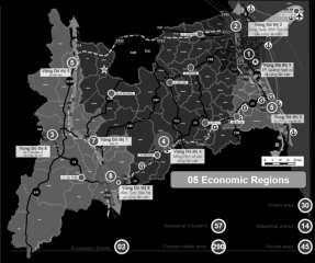
Quang Ngai
Provincial Plan 2021–2030, Vision to 2025
Multidisciplinary Integrated Planning
Location : Quang Ngai Province, Viet Nam;
Area : 5.155,24 km2;
Year : 2021-2023;
Scale : 1/50.000 - 1/100.000;
Approved by : The Prime Minister;
Project owner : People’s Committee of Quang Ngai Province;
Roles : Project Coordinator, GIS and map developer.
Coordinator of the joint venture team
• Focal point for providing information, coordinating the implementation progress of member consulting groups;
• Preside over the synthesis and completion of provincial planning documents, ensuring sufficient conditions for approval;
• Involved in 2 topics: urban and rural system planning; industrial park and cluster system planning;
• Manage publicized planning publications such as posters and films.
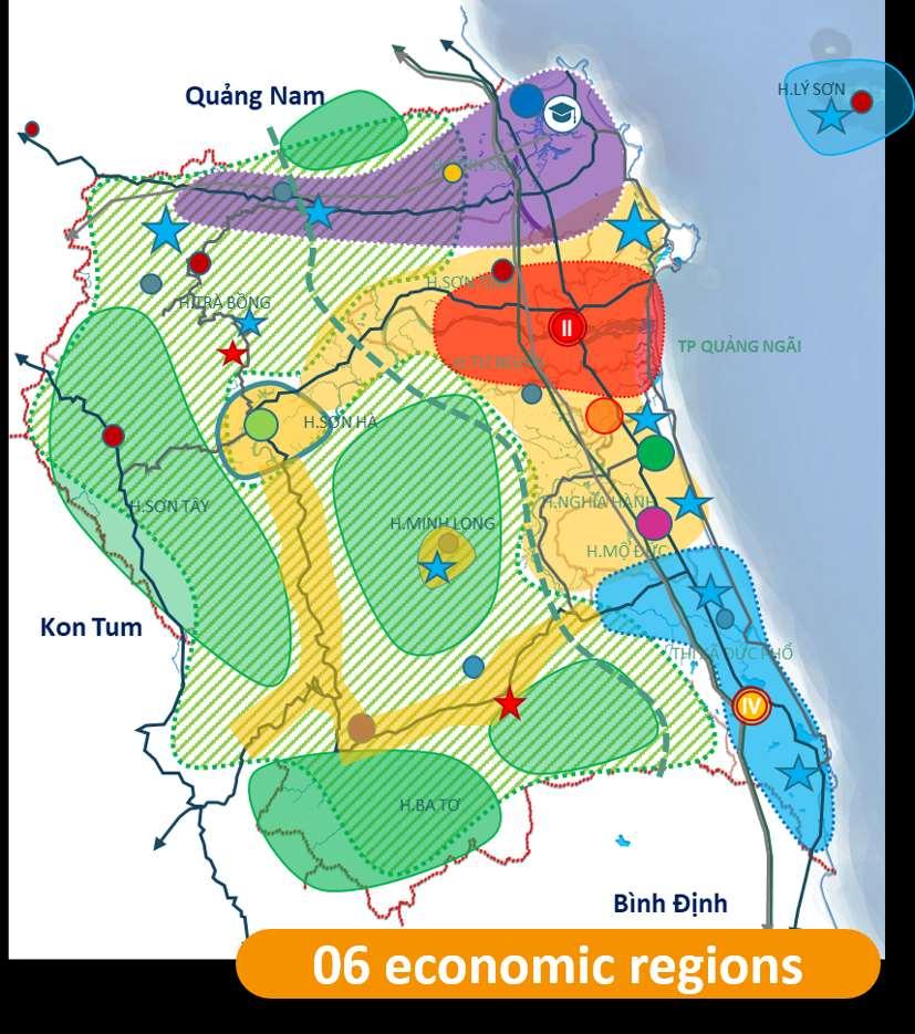
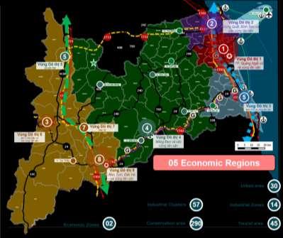
The Quang Ngai Provincial Plan is the first integrated, multi-sectoral provincial-level plan implemented based on the 2017 Planning Law, developed in parallel with many national-level and regional-level plans. The Quang Ngai Provincial Planning comprises 19 main contents, 25 proposed sectoral contents, and 13 district-level topics, and was approved by the Prime Minister under Decision No. 1456/QD-TTg dated November 22, 2023.
Approaches
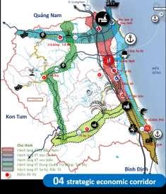
Strategic economic corridor map
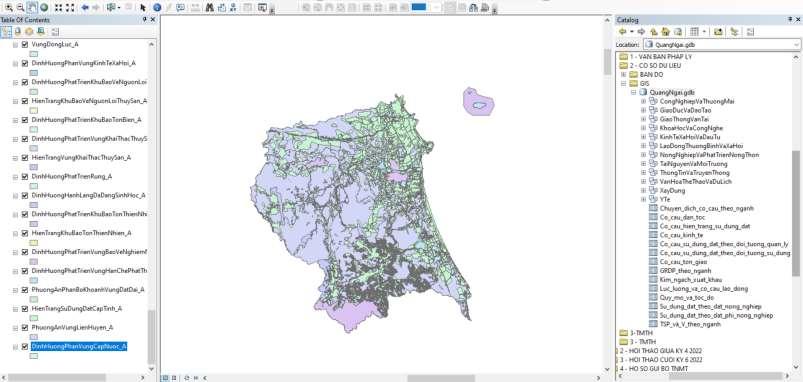
The implementation of GIS (Geographic Information Systems) for the Quang Ngai Provincial Plan is the first time a GIS database has been integrated for provincial-level planning, built based on Circular No. 04/2023/TT-BKHĐT of the Ministry of Planning and Investment dated June 26, 2023. Regarding the database, there are 12 feature datasets categorized by sector, with over 100 feature classes. In terms of maps, there are 29 maps, including 15 sectoral orientation maps.
GIS and map system developer.
• Implement and integrate GIS (Geographic Information Systems) content, ensuring synchronization with provincial planning content;
• Manage content and technical quality in accordance with Circular No. 04/2023/TTBKHĐT of the Ministry of Planning and Investment dated June 26, 2023, ensuring sufficient conditions for approval;
• Provide training to members of the consulting group on GIS implementation.
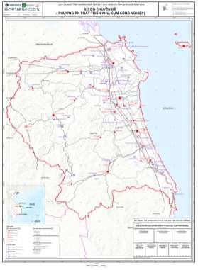
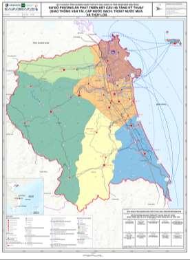
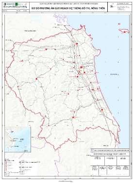
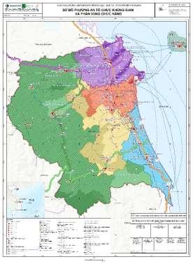
The GIS (Geographic Information Systems) dataset of Quang Ngai Provincial Plan
Map system of Quang Ngai Provincial Plan
Quang Ngai
Adjustment of Provincial Plan
2026–2030, Vision to 2025
Multidisciplinary Integrated Planning
Location : Quang Ngai Province, Viet Nam;
Area : 14.832,55 km2;
Year : 2025-now (Not yet completed);
Scale : 1/50.000 - 1/100.000;
Approved by : People’s Committee of Quang Ngai Province;
Project owner : Department of Finance;
Roles : Planning Expert, GIS and map developer.
Planning Expert
• Adjust the development plans for economic zones, industrial parks, and industrial clusters to suit the new development context of Quang Ngai province.
• Develop database and map that is consistent with the adjustments of provincial plan.
• Assist in coordinating and integrating content from members of the consulting groups.
The Quang Ngai Provincial Planning Adjustment is developed in the context of Vietnam undergoing the merger of provinces and sectors, and still established based on the 2017 Planning Law
Quang Ngai and Kon Tum provinces merged to form Quang Ngai province The content of functional zones, therefore, has undergone many changes, such as Economic Zones, Industrial Zones, and Industrial Clusters. This development orientation was adjusted according to the following rule:
• Eliminate industrial parks, clusters that are no longer suitable in terms of location and effectiveness with new orientation;.
• Add new potential industrial parks, clusters with a role in the new development context of the province.
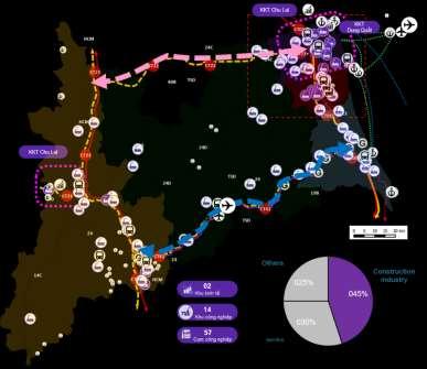


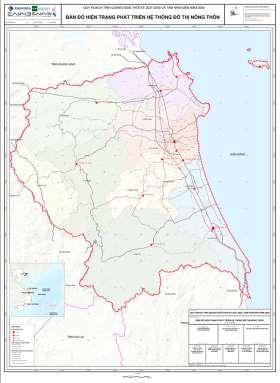
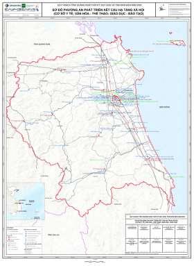
Map system of Quang Ngai Provincial Plan
Arch. Nong Tuan Hung I Portfolio
Industrial parks and clusters system
Economic region
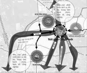
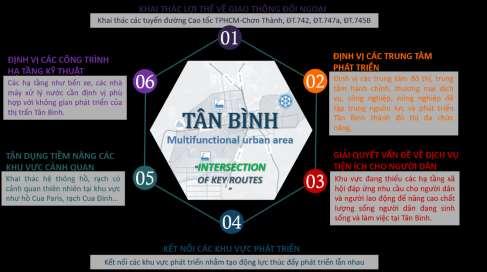
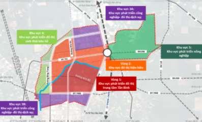
TAN BINH
Master Planning Adjustment
Master Planning
Location :Bac Tan Uyen District, Binh Duong Province, Viet Nam;
Area : 2.893,40 ha;
Population : 17.000 (2030); 40.000 (2045);
Year : 2024-2025 (Not completed); ;
Scale : 1/5.000;
Approved by : People’s Committee of Binh Duong Province;
Project owner : People’s Committee of Bac Tan Uyen District;
Roles : Project Coordinator, Designer.
Project Coordinator / Designer
• Work directly with local agencies to finalize project documentation;
• Present directly the project to the Town People’s Committee and report to the Community Council.
• Do the Planning Task Dossier for the approval;
• Coordinate with groups to implement technical infrastructure documents;
• Collaborate with the project chairman to develop concepts and ideas;
• Transform ideas and concepts into design.
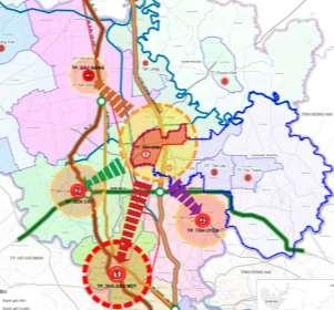
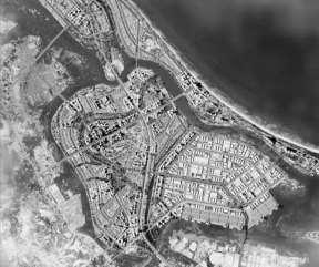
Tan Binh is one of two towns in Bac Tan Uyen district, Binh Duong province. Its main driving force for development is industry and services supporting the industrial zone, thanks to its location on strategic roads in Binh Duong province such as DT.741 (QL.13B), DT.742, DT.747A, and DT.745B. The project aims to exploit the advantages of industrial development and transport connectivity to create strong growth momentum for Tan Binh.
• By 2030, Tan Binh will be a Class V urban area
• By 2040, Tan Binh will meet the criteria for a Class V urban area
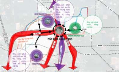
Location of Tan Binh in Binh Duong
TAM HOA TAM TIEN
Zoning Planning / Concept
Tariff Zoning Planning
Location : The Chu Lai Open Economic Zone, Quang Nam;
Area : 796,5 ha;
Year : 2022-now (Not yet completed);
Scale : 1/2.000;
Project owner : Dai Quang Minh Real Estate Investment Corporation ;
Roles : Project Coordinator, Designer.
The Tam Hoa Tam Tien Tariff Zone exploits the potential of the deep-water port in the Chu Lai Open Economic Zone to accommodate large vessels up to 50,000 DWT.
The project focuses on the spatial design of the Tariff zone, Storage area, Logistics area, ports, and surrounding service and residential areas to operate efficiently.
Project Coordinator / Designer
• Translate ideas and concepts from international expert groups into detail design suitable for submission
• Work directly with project owner to finalize project documentation;
• Collaborate 3D team to create a 3D product that matches the concept;
• Coordinator design team.
Location of Tam Hoa Tam Tien Tariff Zone in Chu Lai Economic Zone


TAN AN
Detail Planning
Location :Thu Dau Mot City, Binh Duong Province, Viet Nam;
Area : 289,8 ha;
Population : 30.000;
Year : 2023-2024;
Scale : 1/500;
Project owner : Dai Quang Minh Real Estate
Investment Corporation ;
Roles : Project Coordinator, Designer.

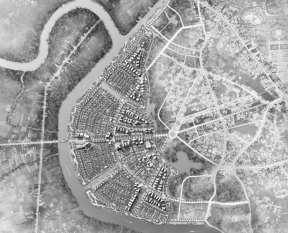
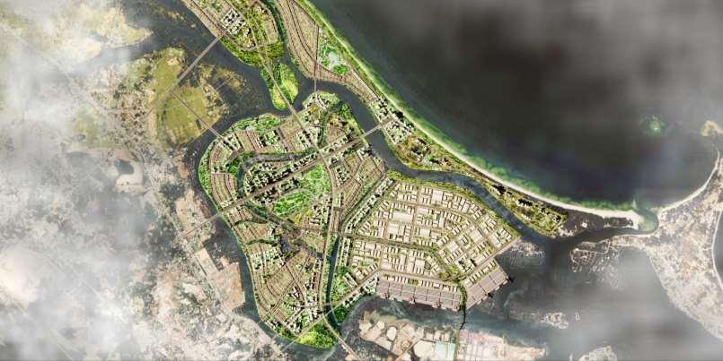
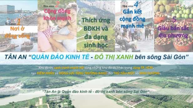
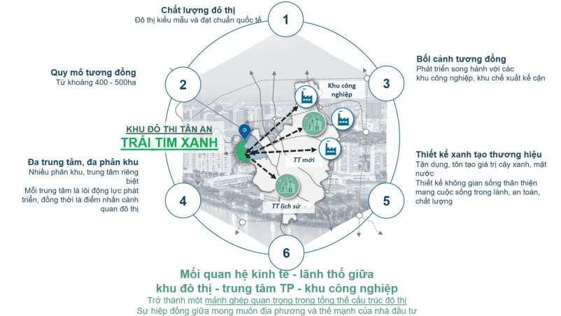
Tan An is located at the ecological development pole in the “development triangle” of Binh Duong province, next to the historical urban pole and the new development area.
Green Urban Living Green Heart
Tan An will be the green heart of Binh Duong province, envisioned as a green urban area that maximizes the use of water and green space to improve quality of life and create a high-class living area, attracting high-skilled workers to live.
Project Coordinator / Designer
• Collaborate with the project chairman to develop concepts and ideas;
• Work directly with project owner to finalize project documentation;
• Collaborate 3D team to create a 3D product that matches the concept;
• Coordinator design team.
High-class Urban Planning Arch. Nong Tuan Hung I
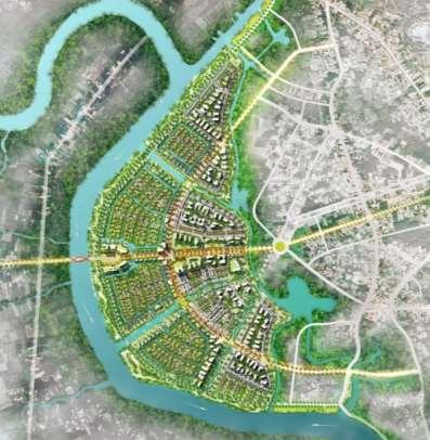
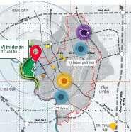
Location of
Tan An in Thu Dau Mot
Functional zoning map
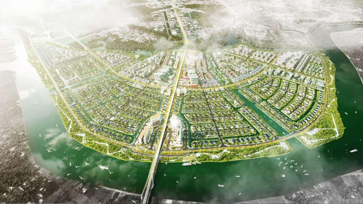
the green heart of Binh Duong
Tan An
TAN AN
Zoning Planning Task
Urban Zoning Planning
Location :Thu Dau Mot City, Binh Duong Province, Viet Nam; Area : 451 ha;
Population : 17.000 (2030); 40.000 (2045); Year : 2024;
Scale : 1/2.000;
Approved by : People’s Committee of Binh Duong Province;
Project owner : Department of Construction;
Roles : Project Coordinator.
Project Coordinator
• Collaborate with the project chairman to develop concepts and ideas;
• Work directly with project owner to finalize project documentation
Tan An is the ecological development hub of Thu Dau Mot City Its development orientation is towards ecological and highclass living, respecting the natural ecosystem..
Location of Tan An in Thu Dau Mot
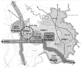
BINH MY
Master Planning Task
Master Planning
Location : Bac Tan Uyen District, Binh Duong Province, Viet Nam;
Area : 5.643,13 ha;
Population : 25.000 (2030); 45.000 (2040);
Year : 2024-2025;
Scale : 1/5.000;
Approved by : People’s Committee of Binh Duong Province;
Project owner : People’s Committee of Bac Tan Uyen District;
Roles : Project Coordinator.

Binh My is a new integrated economic center of Bac Tan Uyen District; a focal area for industrial development; and a satellite urban area supporting the development of trade and services, playing a driving role in socio-economic development
• By 2030, Binh My Commune will meet the criteria for a Class V urban area
Project Coordinator
• Work directly with local agencies to finalize project documentation;
• Present directly the project to the Town People’s Committee and report to the Community Council
• Do the Planning Task Dossier for the approval;

• By 2040, Binh My Commune will consolidate and enhance the criteria for a Class V urban area, moving toward sustainable urban development, environmental friendliness, and becoming a livable urban area of the district; at the same time, it will meet the requirements to upgrade the criteria of Bac Tan Uyen urban area to Class IV and establish a town ”
Location of Binh My in Bac Tan Uyen
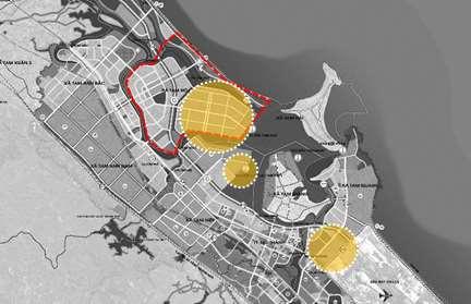
LONG PHU
Regional Plan to 2040, Vision to 2050
Strategic Spatial Plan
Location :Long Phu District, Soc Trang Province, Viet Nam;
Area : 264,76 km2;
Population : 150.000;
Year : 2023-2024 (Not completed);
Scale : 1/25.000;
Approved by : People’s Committee of Soc Trang Province;
Project owner : People’s Committee of Long Phu District;
Roles : Supporter.

Long Phu District is located in the downstream of the Hau River, serves as the eastern gateway of Soc Trang Province Long Phu District lies within the province’s key growth and development zone, forming part of the growth triangle “Soc Trang – Tran De – Dai Ngai”.
The idea for Long Phu is that a key strategic hub for industrial and commercial connectivity and outward regional development within the economic growth triangle of “Soc Trang City – Tran De – Dai Ngai”.
Supporter
• Conduct site visite and analyze the current state of the development context;
• Develop representation.

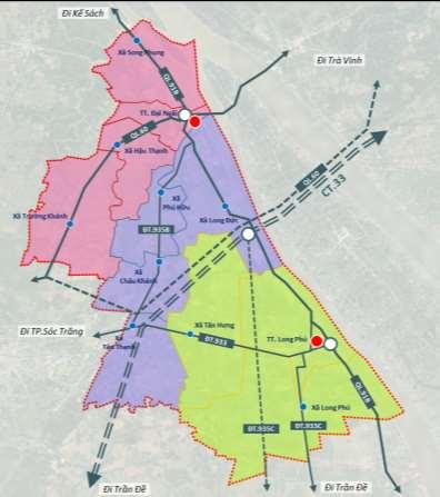
Location of Long Phu in Soc Trang
Functional region map
Urban system and region in Song Trang
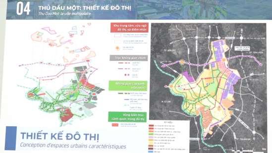
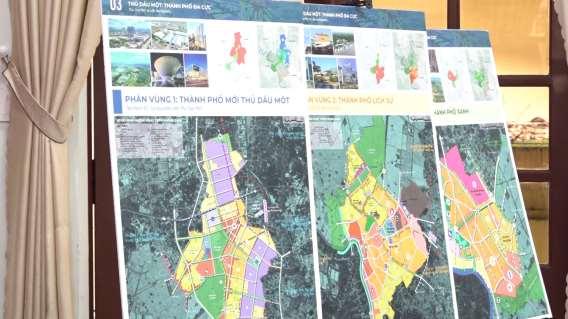
BINH DUONG
Master Planning to 2045
Master Planning
Location :Thu Dau Mot City, Binh Duong Province, Viet Nam;
Area : 11.189 ha;
Population : 450.000;
Year : 2023-2025;
Scale : 1/10.000;
Approved by : The Prime Minister;
Project owner : People’s Committee of Binh Duong Province
Roles : Supporter.
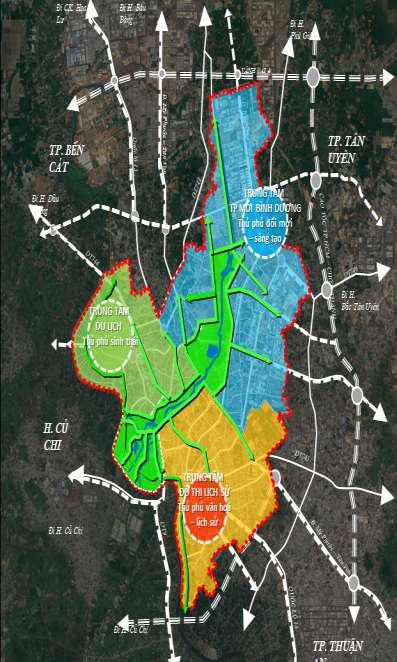
Thu Dau Mot is a Class I urban area; the economic, cultural, and service center of the region, a smart city, and the center of the Binh Duong innovation zone. Urban development is linked to high-tech industries and high-quality services, serving as a transportation hub for domestic and international exchange within the inter-provincial region of Southeast Vietnam.
The master plan for Thu Dau Mot is oriented towards a multi-polar development model; gradually transforming from an "industrial city" structure to a "service and high-tech industrial city, innovation" structure, aiming for smart and sustainable urban development


Supporter
• Conduct site visite and analyze the current state of the development context;
• Develop representation and publications such as posters.
Posters
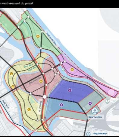
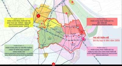
TRAN DE
Master Planning to 2045
Port Urban Area Master planning
Location :Tran De District, Soc Trang Province, Viet Nam; Area : 1.895,23 ha;
Population : 24.700 (2030); 34.600 (2035); Year : 2024-2025;
Scale : 1/5.000;
Approved by : People’s Committee of Soc Trang Province;
Project owner : Department of Construction;
Roles : Supporter, 3D concept developer.
Location of Tran De in Soc Trang

Supporter
• Conduct site visit and analyze the current state of the development context;
3D concept developer
• Produce 3D modeling and rendering for the project.
Tran De Town is a Class V urban, oriented to develop into an urban area serving the coastal economic zone and acting as a growth engine of the Mekong Delta region. Accordingly, Tran De is planned to become a center for aquaculture and marine fisheries exploitation, as well as fisheries logistics services for the eastern coastal region; to promote the development of processing industries, trade, renewable energy, and coastal tourism.


Shining Coastal Economic Urban Center…
Tran De
Freelance


TAM KY 2024 TAM KY 2023


Presented to the appraisal council for the Quang Ngai Provincial Plan at the Ministry of Planning and Investment
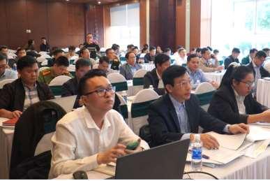
Contributed the insight to the development of a Circular on planning databases.
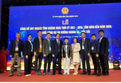
Participated in Planning announcement event of the Quang Ngai Provincial Plan.

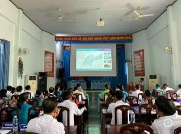
Presented to to the People’s Committee of Tan Binh Town on the Tan Binh Master Plan.
Awarded a full scholarship for academic performance during a semester in Germany.
Honourable mentionAward for ”Future city: Smart design for post pandemic world” Competition.
HU NG
“To lose money is a minor loss; to lose time is a greater loss; but to lose trust is to lose everything.”