Live Atlas
REPORT · EARTHQUAKES
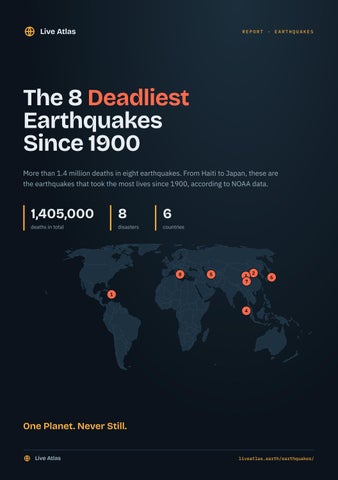
The 8 Deadliest Earthquakes Since 1900 More than 1.4 million deaths in eight earthquakes. From Haiti to Japan, these are the earthquakes that took the most lives since 1900, according to NOAA data.
1,405,000
8
deaths in total
disasters
6
countries
8
5
3 7
2
6
1 4
One Planet. Never Still. Live Atlas
liveatlas.earth/earthquakes/
Live Atlas
No.
8
THE 8 DEADLIEST EARTHQUAKES SINCE 1900
80,000 DEATHS
1908 Messina Earthquake 28 December 1908 · Italy · magnitude 7.0
DATE
MAGNITUDE
DEPTH
28 December 1908
7.0
40 km
ESTIMATED DAMAGE
PLATE
TSUNAMI
116 million US dollars
Eurasian Plate
Yes, 13.0 m wave
On 28 December 1908 at 04:20 UTC, a magnitude 7.0 earthquake struck Italy (Messina, Sicily), at a depth of 40 km. It occurred on the Eurasian Plate, 7 km from its boundary with the African Plate (continental rift). It killed at least 80,000 people (including tsunami victims). It is the 8th deadliest of the earthquakes recorded since 1900.
Live Atlas
liveatlas.earth/earthquakes/1908-italy-messina/
Live Atlas
No.
7
THE 8 DEADLIEST EARTHQUAKES SINCE 1900
87,652 DEATHS
2008 Sichuan Earthquake 12 May 2008 · People's Republic of China · magnitude 7.9
DATE
MAGNITUDE
DEPTH
12 May 2008
7.9
10 km
INJURIES
HOMES DESTROYED
ESTIMATED DAMAGE
374,171
5,360,000
86.0 billion US dollars
PLATE
TSUNAMI
Eurasian Plate
Yes
On 12 May 2008 at 06:28 UTC, a magnitude 7.9 earthquake struck People's Republic of China (Sichuan Province), at a depth of 10 km. It occurred on the Eurasian Plate, 311 km from its boundary with the Yangtze Plate (continental rift). It killed at least 87,652 people and injured 374,171. 5,360,000 homes were destroyed. It is the 7th deadliest of the earthquakes recorded since 1900.
Live Atlas
liveatlas.earth/earthquakes/2008-people-s-republic-of-china-sichuan-province/
Live Atlas
No.
6
THE 8 DEADLIEST EARTHQUAKES SINCE 1900
105,385 DEATHS
1923 Great Kantō Earthquake 1 September 1923 · Japan · magnitude 7.9
DATE
MAGNITUDE
DEPTH
1 September 1923
7.9
35 km
INJURIES
HOMES DESTROYED
ESTIMATED DAMAGE
52,074
695,000
600 million US dollars
PLATE
TSUNAMI
Okhotsk Plate
Yes, 13.0 m wave
On 1 September 1923 at 02:58 UTC, a magnitude 7.9 earthquake struck Japan (Tokyo, Yokohama), at a depth of 35 km. It occurred on the Okhotsk Plate, 26 km from its boundary with the Philippine Sea Plate (continental collision). It killed at least 105,385 people and injured 52,074. 695,000 homes were destroyed. It is the 6th deadliest of the earthquakes recorded since 1900.
Live Atlas
liveatlas.earth/earthquakes/1923-japan-tokyo/
Live Atlas
No.
5
THE 8 DEADLIEST EARTHQUAKES SINCE 1900
110,000 DEATHS
1948 Ashgabat Earthquake 5 October 1948 · Turkmenistan · magnitude 7.2
DATE
MAGNITUDE
DEPTH
5 October 1948
7.2
18 km
ESTIMATED DAMAGE
PLATE
25 million US dollars
Eurasian Plate
On 5 October 1948 at 20:12 UTC, a magnitude 7.2 earthquake struck Turkmenistan (Ashkhabad), at a depth of 18 km. It occurred on the Eurasian Plate. It killed at least 110,000 people. It is the 5th deadliest of the earthquakes recorded since 1900.
Live Atlas
liveatlas.earth/earthquakes/1948-turkmenistan-ashkhabad/
Live Atlas
No.
4
THE 8 DEADLIEST EARTHQUAKES SINCE 1900
227,899 DEATHS
2004 Indian Ocean Earthquake 26 December 2004 · Indonesia · magnitude 9.1
DATE
MAGNITUDE
DEPTH
26 December 2004
9.1
30 km
ESTIMATED DAMAGE
PLATE
TSUNAMI
10.0 billion US dollars
Burma Plate
Yes, 50.9 m wave
On 26 December 2004 at 00:58 UTC, a magnitude 9.1 earthquake struck Indonesia (Sumatra, Aceh), at a depth of 30 km. It occurred on the Burma Plate, 86 km from its boundary with the Sunda Plate (continental rift). It killed at least 227,899 people (including tsunami victims). It is the 4th deadliest and the 3rd most powerful of the earthquakes recorded since 1900.
Live Atlas
liveatlas.earth/earthquakes/2004-indonesia-sumatra/
Live Atlas
No.
3
THE 8 DEADLIEST EARTHQUAKES SINCE 1900
235,502 DEATHS
1920 Haiyuan Earthquake
16 December 1920 · People's Republic of China · magnitude 8.3
DATE
MAGNITUDE
DEPTH
16 December 1920
8.3
25 km
ESTIMATED DAMAGE
PLATE
TSUNAMI
25 million US dollars
Eurasian Plate
Yes
On 16 December 1920 at 12:05 UTC, a magnitude 8.3 earthquake struck People's Republic of China (Gansu Province, Shanxi Province), at a depth of 25 km. It occurred on the Eurasian Plate. It killed at least 235,502 people. It is the 3rd deadliest and the 36th most powerful of the earthquakes recorded since 1900.
Live Atlas
liveatlas.earth/earthquakes/1920-people-s-republic-of-china-gansu-province/
Live Atlas
No.
2
THE 8 DEADLIEST EARTHQUAKES SINCE 1900
242,769 DEATHS
1976 Tangshan Earthquake 27 July 1976 · People's Republic of China · magnitude 7.5
DATE
MAGNITUDE
DEPTH
27 July 1976
7.5
23 km
INJURIES
ESTIMATED DAMAGE
PLATE
799,000
5.6 billion US dollars
Eurasian Plate
On 27 July 1976 at 19:42 UTC, a magnitude 7.5 earthquake struck People's Republic of China (Ne, Tangshan), at a depth of 23 km. It occurred on the Eurasian Plate, 42 km from its boundary with the Amur Plate (continental transform fault). It killed at least 242,769 people and injured 799,000. It is the 2nd deadliest of the earthquakes recorded since 1900. WHAT IS A TRANSFORM FAULT?
A transform fault is a boundary where two plates slide horizontally past each other, neither creating nor destroying crust. Most connect sections of mid-ocean ridges on the sea floor.
Live Atlas
liveatlas.earth/earthquakes/1976-people-s-republic-of-china-ne/
Live Atlas
No.
1
THE 8 DEADLIEST EARTHQUAKES SINCE 1900
316,000 DEATHS
2010 Haiti Earthquake 12 January 2010 · Haiti · magnitude 7.0
DATE
MAGNITUDE
DEPTH
12 January 2010
7.0
13 km
INJURIES
HOMES DESTROYED
ESTIMATED DAMAGE
300,000
97,294
8.0 billion US dollars
PLATE
TSUNAMI
Caribbean Plate
Yes, 3.2 m wave
On 12 January 2010 at 21:53 UTC, a magnitude 7.0 earthquake struck Haiti (Port-Au-Prince), at a depth of 13 km. It occurred on the Caribbean Plate, 209 km from its boundary with the North American Plate (oceanic transform fault). It killed at least 316,000 people and injured 300,000. 97,294 homes were destroyed. It is the deadliest of the earthquakes recorded since 1900. WHAT IS A TRANSFORM FAULT?
A transform fault is a boundary where two plates slide horizontally past each other, neither creating nor destroying crust. Most connect sections of mid-ocean ridges on the sea floor.
Live Atlas
liveatlas.earth/earthquakes/2010-haiti-port-au-prince/
Live Atlas
THE LIVING PLANET
Follow the Earth Live Live Atlas brings earthquakes, erupting volcanoes, cyclones, wildfires and auroras together on one interactive world map, updated continuously from official sources. Every major earthquake, tsunami, eruption and cyclone of recent history has its own page.
The live map
1,746 major earthquakes since 1900
liveatlas.earth
liveatlas.earth/earthquakes
Major volcanic eruptions
liveatlas.earth/eruptions
Country rankings
liveatlas.earth/rankings
Free widgets for your website
liveatlas.earth/widgets
Browser extension for Chrome, Edge and Firefox
liveatlas.earth/extension
Sources: NOAA National Centers for Environmental Information, Global Significant Earthquake Database (doi:10.7289/V5TD9V7K), death tolls including tsunami victims; USGS; Bird (2003) for tectonic plates; Natural Earth for the map. Death tolls of major disasters vary between sources; this report uses NOAA figures. Live Atlas, published by Bigbang Media.
Live Atlas
liveatlas.earth/