Live Atlas
REPORT · NATURAL HAZARDS
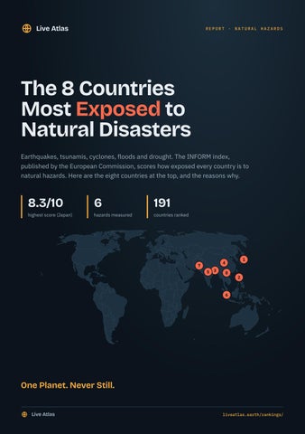
The 8 Countries Most Exposed to Natural Disasters Earthquakes, tsunamis, cyclones, floods and drought. The INFORM index, published by the European Commission, scores how exposed every country is to natural hazards. Here are the eight countries at the top, and the reasons why.
8.3/10
highest score (Japan)
6
hazards measured
191
countries ranked
7
1
4 5 3
8
2
6
One Planet. Never Still. Live Atlas
liveatlas.earth/rankings/
Live Atlas
No.
8
Vietnam
THE 8 COUNTRIES MOST EXPOSED TO NATURAL DISASTERS
7.3/10
EXPOSURE TO NATURAL HAZARDS (INFORM)
Asia · capital Hanoi · 96,208,984 inhabitants
Earthquakes
3.5
Tsunamis
5.9
Tropical Cyclones
5.9
Coastal Floods
9.6
River Floods
9.9
Drought
4.0
POPULATION
ACTIVE VOLCANOES
MAJOR CYCLONES SINCE 1950
96,208,984
2
144
PEOPLE EXPOSED TO STRONG SHAKING EACH YEAR
PEOPLE EXPOSED TO HURRICANEFORCE WINDS EACH YEAR
PEOPLE EXPOSED TO RIVER FLOODS EACH YEAR
34,967
1,447,761
3,882,319
Vietnam spans the Sunda and Eurasian plates. It has 2 volcanoes active over the last 10,000 years, 1 of which have erupted since 1900. Since 1900, 6 major earthquakes have been recorded. Its exposure to natural hazards is 7.3 out of 10 (INFORM index), a very high level. Its overall risk index, which accounts for its ability to cope, is 3.9 out of 10. WHY SO EXPOSED?
Its highest hazard scores are river floods (9.9), coastal floods (9.6) and tsunamis (5.9), on a scale of 0 to 10. The figures above count the people living in areas hit, on average, each year.
Live Atlas
liveatlas.earth/asia/vietnam/
Live Atlas
No.
7
Pakistan
THE 8 COUNTRIES MOST EXPOSED TO NATURAL DISASTERS
7.4/10
EXPOSURE TO NATURAL HAZARDS (INFORM)
Asia · capital Islamabad · 223,773,700 inhabitants
Earthquakes
9.2
Tsunamis
6.1
Tropical Cyclones
7.1
Coastal Floods
4.5
River Floods
9.5
Drought
4.5
POPULATION
ACTIVE VOLCANOES
MAJOR CYCLONES SINCE 1950
223,773,700
0
2
PEOPLE EXPOSED TO STRONG SHAKING EACH YEAR
PEOPLE EXPOSED TO HURRICANEFORCE WINDS EACH YEAR
PEOPLE EXPOSED TO RIVER FLOODS EACH YEAR
525,655
995,521
5,844,697
Pakistan spans the Eurasian and Indian plates. Since 1900, 46 major earthquakes have been recorded, causing at least 143,700 deaths. Its exposure to natural hazards is 7.4 out of 10 (INFORM index), a very high level. Its overall risk index, which accounts for its ability to cope, is 6.6 out of 10. WHY SO EXPOSED?
Its highest hazard scores are river floods (9.5), earthquakes (9.2) and tropical cyclones (7.1), on a scale of 0 to 10. The figures above count the people living in areas hit, on average, each year.
Live Atlas
liveatlas.earth/asia/pakistan/
Live Atlas
No.
6
Indonesia
THE 8 COUNTRIES MOST EXPOSED TO NATURAL DISASTERS
7.4/10
EXPOSURE TO NATURAL HAZARDS (INFORM)
Asia · capital Jakarta · 275,439,000 inhabitants
Earthquakes
8.9
Tsunamis
9.3
Tropical Cyclones
1.6
Coastal Floods
8.1
River Floods
8.4
Drought
3.3
POPULATION
ACTIVE VOLCANOES
MAJOR CYCLONES SINCE 1950
275,439,000
101
6
PEOPLE EXPOSED TO STRONG SHAKING EACH YEAR
PEOPLE EXPOSED TO HURRICANEFORCE WINDS EACH YEAR
PEOPLE EXPOSED TO RIVER FLOODS EACH YEAR
511,573
7,763
1,717,989
Indonesia spans the Sunda, Bird's Head, Banda Sea, Timor, Molucca Sea and Australian plates. It has 101 volcanoes active over the last 10,000 years, 66 of which have erupted since 1900. Since 1900, 324 major earthquakes have been recorded, causing at least 261,588 deaths. Its exposure to natural hazards is 7.4 out of 10 (INFORM index), a very high level. Its overall risk index, which accounts for its ability to cope, is 4.5 out of 10. WHY SO EXPOSED?
Its highest hazard scores are tsunamis (9.3), earthquakes (8.9) and river floods (8.4), on a scale of 0 to 10. The figures above count the people living in areas hit, on average, each year.
Live Atlas
liveatlas.earth/asia/indonesia/
Live Atlas
No.
5
India
THE 8 COUNTRIES MOST EXPOSED TO NATURAL DISASTERS
7.8/10
EXPOSURE TO NATURAL HAZARDS (INFORM)
Asia · capital New Delhi · 1,326,093,247 inhabitants
Earthquakes
8.3
Tsunamis
7.8
Tropical Cyclones
7.7
Coastal Floods
7.8
River Floods
9.2
Drought
5.9
POPULATION
ACTIVE VOLCANOES
MAJOR CYCLONES SINCE 1950
1,326,093,247
1
32
PEOPLE EXPOSED TO STRONG SHAKING EACH YEAR
PEOPLE EXPOSED TO HURRICANEFORCE WINDS EACH YEAR
PEOPLE EXPOSED TO RIVER FLOODS EACH YEAR
1,772,428
7,671,259
16,884,210
India spans the Indian, Eurasian and Burma plates. It has 1 volcano active over the last 10,000 years, 1 of which have erupted since 1900. Since 1900, 77 major earthquakes have been recorded, causing at least 52,844 deaths. Its exposure to natural hazards is 7.8 out of 10 (INFORM index), a very high level. Its overall risk index, which accounts for its ability to cope, is 5.2 out of 10. WHY SO EXPOSED?
Its highest hazard scores are river floods (9.2), earthquakes (8.3) and tsunamis (7.8), on a scale of 0 to 10. The figures above count the people living in areas hit, on average, each year.
Live Atlas
liveatlas.earth/asia/india/
Live Atlas
No.
4
THE 8 COUNTRIES MOST EXPOSED TO NATURAL DISASTERS
7.8/10
EXPOSURE TO NATURAL HAZARDS (INFORM)
People's Republic of China Asia · capital Beijing · 1,404,890,000 inhabitants
Earthquakes
6.7
Tsunamis
9.0
Tropical Cyclones
7.8
Coastal Floods
9.0
River Floods
9.3
Drought
4.6
POPULATION
ACTIVE VOLCANOES
MAJOR CYCLONES SINCE 1950
1,404,890,000
9
288
PEOPLE EXPOSED TO STRONG SHAKING EACH YEAR
PEOPLE EXPOSED TO HURRICANEFORCE WINDS EACH YEAR
PEOPLE EXPOSED TO RIVER FLOODS EACH YEAR
870,139
28,970,127
21,681,628
People's Republic of China spans the Eurasian, Amur and Yangtze plates. It has 9 volcanoes active over the last 10,000 years, 2 of which have erupted since 1900. Since 1900, 374 major earthquakes have been recorded, causing at least 714,518 deaths. Its exposure to natural hazards is 7.8 out of 10 (INFORM index), a very high level. Its overall risk index, which accounts for its ability to cope, is 2.9 out of 10. WHY SO EXPOSED?
Its highest hazard scores are river floods (9.3), tsunamis (9.0) and coastal floods (9.0), on a scale of 0 to 10. The figures above count the people living in areas hit, on average, each year.
Live Atlas
liveatlas.earth/asia/people-s-republic-of-china/
Live Atlas
No.
3
THE 8 COUNTRIES MOST EXPOSED TO NATURAL DISASTERS
8.1/10
EXPOSURE TO NATURAL HAZARDS (INFORM)
Bangladesh
Asia · capital Dhaka · 171,466,990 inhabitants
Earthquakes
8.9
Tsunamis
8.1
Tropical Cyclones
7.9
Coastal Floods
8.9
River Floods
9.9
Drought
1.5
POPULATION
ACTIVE VOLCANOES
MAJOR CYCLONES SINCE 1950
171,466,990
0
13
PEOPLE EXPOSED TO STRONG SHAKING EACH YEAR
PEOPLE EXPOSED TO HURRICANEFORCE WINDS EACH YEAR
PEOPLE EXPOSED TO RIVER FLOODS EACH YEAR
370,108
2,646,604
6,711,870
Bangladesh lies on the Indian Plate. Since 1900, 13 major earthquakes have been recorded, causing at least 115 deaths. Its exposure to natural hazards is 8.1 out of 10 (INFORM index), a very high level. Its overall risk index, which accounts for its ability to cope, is 5.9 out of 10. WHY SO EXPOSED?
Its highest hazard scores are river floods (9.9), earthquakes (8.9) and coastal floods (8.9), on a scale of 0 to 10. The figures above count the people living in areas hit, on average, each year.
Live Atlas
liveatlas.earth/asia/bangladesh/
Live Atlas
No.
2
THE 8 COUNTRIES MOST EXPOSED TO NATURAL DISASTERS
8.2/10
EXPOSURE TO NATURAL HAZARDS (INFORM)
Philippines
Asia · capital Manila · 112,729,484 inhabitants
Earthquakes
9.7
Tsunamis
9.4
Tropical Cyclones
9.2
Coastal Floods
8.9
River Floods
6.7
Drought
3.5
POPULATION
ACTIVE VOLCANOES
MAJOR CYCLONES SINCE 1950
112,729,484
23
232
PEOPLE EXPOSED TO STRONG SHAKING EACH YEAR
PEOPLE EXPOSED TO HURRICANEFORCE WINDS EACH YEAR
PEOPLE EXPOSED TO RIVER FLOODS EACH YEAR
238,766
9,066,531
338,782
The Philippines spans the Sunda and Philippine Sea plates. It has 23 volcanoes active over the last 10,000 years, 10 of which have erupted since 1900. Since 1900, 143 major earthquakes have been recorded, causing at least 14,332 deaths. Its exposure to natural hazards is 8.2 out of 10 (INFORM index), a very high level. Its overall risk index, which accounts for its ability to cope, is 5.3 out of 10. WHY SO EXPOSED?
Its highest hazard scores are earthquakes (9.7), tsunamis (9.4) and tropical cyclones (9.2), on a scale of 0 to 10. The figures above count the people living in areas hit, on average, each year.
Live Atlas
liveatlas.earth/asia/philippines/
Live Atlas
No.
1
Japan
THE 8 COUNTRIES MOST EXPOSED TO NATURAL DISASTERS
8.3/10
EXPOSURE TO NATURAL HAZARDS (INFORM)
Asia · capital Tokyo · 123,802,000 inhabitants
Earthquakes
9.7
Tsunamis
10.0
Tropical Cyclones
9.2
Coastal Floods
9.4
River Floods
7.8
Drought
0.4
POPULATION
ACTIVE VOLCANOES
MAJOR CYCLONES SINCE 1950
123,802,000
107
171
PEOPLE EXPOSED TO STRONG SHAKING EACH YEAR
PEOPLE EXPOSED TO HURRICANEFORCE WINDS EACH YEAR
PEOPLE EXPOSED TO RIVER FLOODS EACH YEAR
251,283
11,213,763
808,730
Japan spans the Amur, Okhotsk and Okinawa plates. It has 107 volcanoes active over the last 10,000 years, 48 of which have erupted since 1900. Since 1900, 263 major earthquakes have been recorded, causing at least 150,565 deaths. Its exposure to natural hazards is 8.3 out of 10 (INFORM index), a very high level. Its overall risk index, which accounts for its ability to cope, is 2.0 out of 10. WHY SO EXPOSED?
Its highest hazard scores are tsunamis (10.0), earthquakes (9.7) and coastal floods (9.4), on a scale of 0 to 10. The figures above count the people living in areas hit, on average, each year.
Live Atlas
liveatlas.earth/asia/japan/
Live Atlas
THE LIVING PLANET
Follow the Earth Live Live Atlas brings earthquakes, erupting volcanoes, cyclones, wildfires and auroras together on one interactive world map, updated continuously from official sources. Every major earthquake, tsunami, eruption and cyclone of recent history has its own page.
The live map
1,746 major earthquakes since 1900
liveatlas.earth
liveatlas.earth/earthquakes
Major volcanic eruptions
liveatlas.earth/eruptions
Country rankings
liveatlas.earth/rankings
Free widgets for your website
liveatlas.earth/widgets
Browser extension for Chrome, Edge and Firefox
liveatlas.earth/extension
Sources: INFORM Risk Index (1 September 2026 v 0.7.3), European Commission Joint Research Centre, CC BY 4.0, natural hazard exposure dimension; NOAA NCEI (earthquakes and tsunamis since 1900); IBTrACS (cyclones since 1950); Smithsonian Global Volcanism Program (volcanoes); Natural Earth. Live Atlas, published by Bigbang Media.
Live Atlas
liveatlas.earth/