Live Atlas
REPORT · VOLCANOES
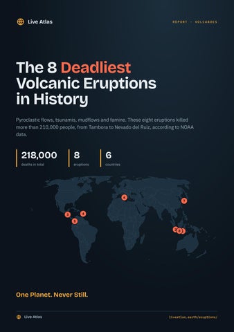
The 8 Deadliest Volcanic Eruptions in History Pyroclastic flows, tsunamis, mudflows and famine. These eight eruptions killed more than 210,000 people, from Tambora to Nevado del Ruiz, according to NOAA data.
218,000
8
deaths in total
eruptions
6
countries
6
7
4
3 5
2 81
One Planet. Never Still. Live Atlas
liveatlas.earth/eruptions/
Live Atlas
No.
8
THE 8 DEADLIEST VOLCANIC ERUPTIONS IN HISTORY
10,000 DEATHS
1586 Eruption of Kelud 1586 · Indonesia · VEI 5
DATE
VOLCANO TYPE
ELEVATION
1586
Stratovolcano
1,730 m
COUNTRY
EXPLOSIVITY (VEI)
Indonesia
5 out of 8
In 1586, Kelud in Indonesia erupted. The volcano rises to 1,730 m. Its Volcanic Explosivity Index (VEI) is 5 out of 8, that of a paroxysmal eruption ejecting more than 1 km³ of material. It killed at least 10,000 people. It is the 8th deadliest eruption recorded by NOAA. ABOUT KELUD
Kelud, in eastern Java, long held a crater lake that fed deadly lahars. In 1919 one of them killed about 5,000 people, and tunnels were later dug to lower the level of the lake.
Live Atlas
liveatlas.earth/eruptions/kelud-1586/
Live Atlas
No.
7
THE 8 DEADLIEST VOLCANIC ERUPTIONS IN HISTORY
15,000 DEATHS
1792 Eruption of Unzendake 21 May 1792 · Japan · VEI 2
DATE
VOLCANO TYPE
ELEVATION
21 May 1792
Volcanic complex
1,483 m
COUNTRY
EXPLOSIVITY (VEI)
INJURIES
Japan
2 out of 8
707
HOMES DESTROYED
MAIN CAUSES OF DEATH
6,200
Tsunami, Debris Avalanche
On 21 May 1792, Unzendake in Japan erupted. The volcano rises to 1,483 m. Its Volcanic Explosivity Index (VEI) is 2 out of 8, that of a explosive eruption ejecting more than 1 million m³ of material. It killed at least 15,000 people and injured 707. Most deaths were caused by the tsunami and a debris avalanche. It is the 7th deadliest eruption recorded by NOAA. 6,200 homes were destroyed. ABOUT UNZENDAKE
Mount Unzen, on the island of Kyushu, is linked to Japan's worst volcanic disaster. In 1792 the collapse of one of its domes set off a tsunami in Ariake Bay that killed about 15,000 people.
Live Atlas
liveatlas.earth/eruptions/unzendake-1792/
Live Atlas
No.
6
THE 8 DEADLIEST VOLCANIC ERUPTIONS IN HISTORY
16,000 DEATHS
1169 Eruption of Mount Etna 4 February 1169 · Italy
DATE
VOLCANO TYPE
ELEVATION
4 February 1169
Stratovolcano
3,357 m
COUNTRY
MAIN CAUSES OF DEATH
Italy
Earthquakes, Tsunami
On 4 February 1169, Mount Etna in Italy erupted. The volcano rises to 3,357 m. It killed at least 16,000 people. Most deaths were caused by earthquakes and the tsunami. It is the 6th deadliest eruption recorded by NOAA. ABOUT MOUNT ETNA
Mount Etna towers over eastern Sicily and is one of the most active volcanoes on Earth. Its height shifts with each eruption, at around 3,350 m, making it the highest active volcano in Europe.
Live Atlas
liveatlas.earth/eruptions/mount-etna-1169/
Live Atlas
No.
5
THE 8 DEADLIEST VOLCANIC ERUPTIONS IN HISTORY
23,080 DEATHS
1985 Eruption of Nevado del Ruiz 13 November 1985 · Colombia · VEI 3
DATE
VOLCANO TYPE
ELEVATION
13 November 1985
Stratovolcano
5,279 m
COUNTRY
EXPLOSIVITY (VEI)
INJURIES
Colombia
3 out of 8
10,000
MAIN CAUSES OF DEATH
Lahars
On 13 November 1985, Nevado del Ruiz in Colombia erupted. The volcano rises to 5,279 m. Its Volcanic Explosivity Index (VEI) is 3 out of 8, that of a severe eruption ejecting more than 10 million m³ of material. It killed at least 23,080 people and injured 10,000. Most deaths were caused by lahars (volcanic mudflows). It is the 5th deadliest eruption recorded by NOAA. ABOUT NEVADO DEL RUIZ
Nevado del Ruiz, in the Andes of Colombia, carries an ice cap above 5,000 m.
Live Atlas
liveatlas.earth/eruptions/nevado-del-ruiz-1985/
Live Atlas
No.
4
THE 8 DEADLIEST VOLCANIC ERUPTIONS IN HISTORY
28,000 DEATHS
8 May 1902 Eruption of Mount Pelée 8 May 1902 · Martinique · VEI 4
DATE
VOLCANO TYPE
ELEVATION
8 May 1902
Stratovolcano
1,372 m
COUNTRY
EXPLOSIVITY (VEI)
MAIN CAUSES OF DEATH
Martinique
4 out of 8
Pyroclastic Flows
On 8 May 1902, Mount Pelée in Martinique erupted. The volcano rises to 1,372 m. Its Volcanic Explosivity Index (VEI) is 4 out of 8, that of a cataclysmic eruption ejecting more than 0.1 km³ of material. It killed at least 28,000 people. Most deaths were caused by pyroclastic flows. It is the 4th deadliest eruption recorded by NOAA. ABOUT MOUNT PELÉE
Mount Pelée, in northern Martinique, is known for the disaster of 8 May 1902. A glowing avalanche of hot gas and ash swept over the town of Saint-Pierre within minutes and killed about 28,000 people.
Live Atlas
liveatlas.earth/eruptions/mount-pelee-1902/
Live Atlas
No.
3
THE 8 DEADLIEST VOLCANIC ERUPTIONS IN HISTORY
30,000 DEATHS
450 Eruption of Ilopango 450 · El Salvador · VEI 6
DATE
VOLCANO TYPE
ELEVATION
450
Caldera
450 m
COUNTRY
EXPLOSIVITY (VEI)
El Salvador
6 out of 8
In 450, Ilopango in El Salvador erupted. The volcano rises to 450 m. Its Volcanic Explosivity Index (VEI) is 6 out of 8, that of a colossal eruption ejecting more than 10 km³ of material. It killed at least 30,000 people. It is the 3rd deadliest eruption recorded by NOAA. ABOUT ILOPANGO
Lake Ilopango, east of San Salvador, fills the caldera of a volcano that produced one of the largest eruptions in Central America.
Live Atlas
liveatlas.earth/eruptions/ilopango-450/
Live Atlas
No.
2
THE 8 DEADLIEST VOLCANIC ERUPTIONS IN HISTORY
36,417 DEATHS
1883 Eruption of Krakatau 27 August 1883 · Indonesia · VEI 6
DATE
VOLCANO TYPE
ELEVATION
27 August 1883
Caldera
285 m
COUNTRY
EXPLOSIVITY (VEI)
HOMES DESTROYED
Indonesia
6 out of 8
101 to 1,000
MAIN CAUSES OF DEATH
Tsunami, Pyroclastic Flows, Indirect Effects (Famine, Disease)
On 27 August 1883, Krakatau in Indonesia erupted. The volcano rises to 285 m. Its Volcanic Explosivity Index (VEI) is 6 out of 8, that of a colossal eruption ejecting more than 10 km³ of material. It killed at least 36,417 people. Most deaths were caused by the tsunami, pyroclastic flows and indirect effects (famine, disease). It is the 2nd deadliest eruption recorded by NOAA. ABOUT KRAKATAU
Krakatau lies in the Sunda Strait, between Java and Sumatra. In August 1883 its eruption destroyed most of the island, and its explosions were heard thousands of kilometres away.
Live Atlas
liveatlas.earth/eruptions/krakatau-1883/
Live Atlas
No.
1
THE 8 DEADLIEST VOLCANIC ERUPTIONS IN HISTORY
60,000 DEATHS
1815 Eruption of Tambora 10 April 1815 · Indonesia · VEI 7
DATE
VOLCANO TYPE
ELEVATION
10 April 1815
Stratovolcano
2,850 m
COUNTRY
EXPLOSIVITY (VEI)
HOMES DESTROYED
Indonesia
7 out of 8
more than 1,000
MAIN CAUSES OF DEATH
Pyroclastic Flows, Tsunami, Debris Avalanche, Indirect Effects (Famine, Disease)
On 10 April 1815, Tambora in Indonesia erupted. The volcano rises to 2,850 m. Its Volcanic Explosivity Index (VEI) is 7 out of 8, that of a super-colossal eruption ejecting more than 100 km³ of material. It killed at least 60,000 people. Most deaths were caused by pyroclastic flows, the tsunami, a debris avalanche and indirect effects (famine, disease). It is the deadliest eruption recorded by NOAA. ABOUT TAMBORA
Tambora, on the island of Sumbawa in Indonesia, produced the most powerful eruption in recorded history in April 1815, with an explosivity index of 7. The summit lost more than a kilometre of height, leaving a caldera six kilometres wide.
Live Atlas
liveatlas.earth/eruptions/tambora-1815/
Live Atlas
THE LIVING PLANET
Follow the Earth Live Live Atlas brings earthquakes, erupting volcanoes, cyclones, wildfires and auroras together on one interactive world map, updated continuously from official sources. Every major earthquake, tsunami, eruption and cyclone of recent history has its own page.
The live map
1,746 major earthquakes since 1900
liveatlas.earth
liveatlas.earth/earthquakes
Major volcanic eruptions
liveatlas.earth/eruptions
Country rankings
liveatlas.earth/rankings
Free widgets for your website
liveatlas.earth/widgets
Browser extension for Chrome, Edge and Firefox
liveatlas.earth/extension
Sources: NOAA National Centers for Environmental Information, Global Significant Volcanic Eruptions Database (doi:10.7289/V5JW8BSH); Smithsonian Institution Global Volcanism Program; Natural Earth for the map. Death tolls of ancient eruptions are estimates and vary between sources; this report uses NOAA figures. Live Atlas, published by Bigbang Media.
Live Atlas
liveatlas.earth/