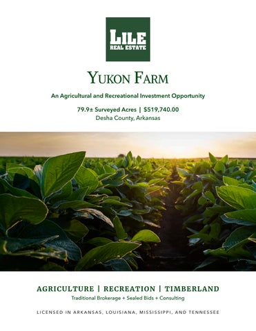
propert Y Description
YUKON FARM
The Yukon Farm consists of 79.96± surveyed acres located in Desha County, Arkansas near Winchester. The Farm Service Agency reports a total of 61.76± tillable acres, of which the majority has been precision leveled. Approximately 830± feet of underground pipeline has been installed for irrigation and there are also two irrigation wells. Access is considered great as the property is located not far off of U.S.
Highway 65. The property is located in a known waterfowl flyway and is well suited for hunting blinds. Waterfowl hunting is improved by the property adjoining the Boeuf River and it being easy to flood. The tillable acres are typically planted in rice, soybeans, and corn, which provides excellent duck food as well. Additional recreational opportunities include dove hunting and whitetail deer hunting.
Location & access
Winchester, Desha, Arkansas
Southeastern Region of Arkansas
Mileage Chart
Monticello, AR 26 Miles
Greenville, MS 56 Miles
Pine Bluff, AR 48 Miles
Monroe, LA 110 Miles
The property is accessible via an improved field road.
topographY map
DESCRIPTION OF 79.96 ACRE TRACT OF LAND
Description of a 79.96 acre tract of land situated in a portion of Section 25, T 10 S - R 4 W and Section 30, T 10 S - R 3 W, Desha County, Arkansas, further described as follows;
BEGINNING at a found 5/8” rebar being the West ¼ Corner of Section 30, T 10 S - R 3 W, Desha County, Arkansas thence run South 87°48'13" East along the north line of Southwest ¼ for 1736.77 feet to a point in the centerline of the L-9 Canal; thence run the following courses and distances along said centerline; South 10°30'58" West 73.39 feet; South 13°43'04" West 226.10 feet; South 20°17'21" West 97.32 feet; South 27°32'13" West 186.40 feet; South 37°47'02" West 189.80 feet; South 42°29'11" West 173.10 feet; South 30°27'23" West 182.60 feet at the intersection of the L-9 Canal and the centerline of Amos Bayou; thence run the following courses and distances along said centerline of Amos Bayou; North 56°04'55" West 44.86 feet; North 67°53'34" West 90.22 feet; North 66°34'24" West 128.54 feet; South 33°59'28" West 209.13 feet; South 69°39'57" West 98.53 feet; South 69°39'57" West 87.18 feet; South 70°09'43" West 137.46 feet; South 63°29'03" West 185.19 feet; North 78°27'28" West 122.03 feet; South 75°59'26" West 65.57 feet; South 65°06'46" West 167.03 feet; South 65°58'52" West for 75.96 feet to a point in the west line of Section 30; thence run South 00°15'20” West along the east line of Section 25, T 10 S - R 4 W for 201.47 feet to the southeast corner of the Northeast ¼ of the Southeast ¼ of Section 25; thence run South 89°30'07” West along the south line of said Northeast ¼ of the Southeast ¼ for 1322.45 feet to a found 5/8” rebar at the southwest corner thereof; thence run North 00°08'03" East along the west line of said Northeast ¼ of the Southeast ¼ for 1320.88 feet to a found 5/8” rebar at the northwest corner thereof; thence run North 89°33'17" East along
717.08 feet North and 3687.90 feet West of the Southeast Corner of Section courses and distances along said centerline; North 89°53'58” West 1659.73 South 00°17'33” West 615.38 feet; thence run South 47°08'39” East along
both sides of described centerline and is situated in a portion of Sections Frank L. Messinger, Professional Land Surveyor of Messinger & Associates,
Description of a 15.76 acre described as follows;
BEGINNING at a found 10 S - R 4 W, Desha County, Pacific Railroad; thence 553.78 feet to a found 5/8” point; thence run South The Point Of Beginning.
The above described tract Frank L. Messinger, Professional road along the western
Description of a 43.80 acre Desha County, Arkansas,
BEGINNING at a found R 4 W, Desha County, Arkansas a found 5/8” rebar with thence run North 00°48'04" run South 03°44'17" West South 00°28'44" East along the southeast corner thereof
The above described tract County, Arkansas, as surveyed
"Mark Moreland"
"Shari Thorne"
Mineral Rights
All mineral rights owned by the Seller, if any, shall transfer to the Buyer.
Offering Price
$519,740.00
To learn more about the Yukon Farm or to schedule a property tour, contact Brandon Stafford of Lile Real Estate, Inc.
Farm serVice agencY
DISCLOSURE STATEMENT: Lile Real Estate, Inc. is the listing agency for the owner of the property described within this offering brochure. A representative of Lile Real Estate, Inc. must be present to conduct a showing.
The management of Lile Real Estate, Inc. respectfully requests that interested parties contact us in advance to schedule a proper showing and do not attempt to tour or trespass on the property on their own. Thank you for your cooperation.
Some images shown within this offering brochure are used for representative purposes and may not have been taken on location at the subject property. This offering is subject to errors, omissions, change or withdrawal without notice. All information provided herein is intended as a general guideline and has been provided by sources deemed reliable, but the accuracy of which we cannot guarantee.
Lile