



I acknowledge the Traditional Owners of the diverse lands on which we live and work and recognise their deep spiritual connection to land, air and water as Custodians of Country.
We pay our respects to all First Nations people and to their ancient and enduring culture.


The portfolio is organised to highlight my experience and understanding of working on projects across various categories. It begins with Public Domain & Streetscape Design, Town Planning Landscape Design, and Documentation, as well as Landscape Visual Impact Assessment projects. These sections emphasise my expertise in graphic analysis, visualisation, report writing, and planting knowledge. Throughout these projects, I demonstrate technical skills such as GIS capabilities, framework planning, graphic outputs, and 3D modelling.

1.Public
2.Public Domain & Streetscape Design - Mullumbimby Streetscape Upgrades for Byron Shire Council 10
3.Public Domain & Streetscape Design - Main Yarra Trail Gipps Street Ramp Functional Design for Parks Victoria 12
4.Public Domain & Streetscape Design - Falls to Hotham Alpine Crossing Hiker Accommodation for Parks Victoria 18
5.Town Planning Landscape Design and Documentation - 54-61 Forrest Avenue, Newhaven20
6.Town
Port Campbell Township Improvements, Port Campbell for Corangamite Shire Council , Victoria
The Port Campbell Township Improvements Project aims to enhance the functionality and appeal of the town’s core for residents and visitors. Key components of the initiative include streetscape upgrades, enhanced visitor amenities, creation of outdoor spaces, a focus on sustainability, improved traffic flow and accessibility, parking solutions, upgraded street lighting, integrated artwork, and preparation for electric vehicle infrastructure. This comprehensive strategy seeks to revitalize Port Campbell, fostering greater appeal, sustainability, and accessibility for the community and tourists alike.
The Masterplan emphasizes the public realm aspect of the Port Campbell Township Interface Plan, with significant investments in key areas such as Lord Street’s streetscape and the foreshore. These improvements are designed to position Port Campbell as a central hub of the Shipwreck Coast.
Adopting a human-centered design approach, the project prioritises the needs of both the local community and visitors. I have contributed to the detailed design and tender documentation following the Masterplan phase, with the project now in its pre-construction phase.


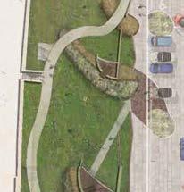


Accessible parking bay


Outdoor dining opportunities for local business


EX.

LWD-X01
LORD STREET LWD-X10
TREE PROTECTION NOTE:
TREE PROTECTION ZONE
UNLESS OTHERWISE AGREED IN WRITING BY THE RESPONSIBLE AUTHORITY, PRIOR TO THE COMMENCEMENT OF WORKS (INCLUDING DEMOLITION) ON THE SITE A TREE PROTECTION ZONE MUST BE ESTABLISHED AROUND THE TREES WITHIN THE PARK. THE CONTRACTOR MUST CONTACT COUNCIL'S DEVELOPMENT PLANNING
ARBORIST ONCE THE TREE PRESERVATION FENCING IS ERECTED SO THAT AN INSPECTION OF THE FENCING CAN BE CARRIED OUT. ONCE INSTALLED AND INSPECTED THE TREE PROTECTION ZONES MUST BE MAINTAINED TO THE RESPONSIBLE AUTHORITY, AND MEET THE FOLLOWING REQUIREMENTS:
STRUCTURAL ROOT ZONE
NON-DESTRUCTIVE DIGGING EXCAVATION IS REQUIRED WITHIN TREE'S SRZ.
ARBORIST SUPERVISION
PREFERENCE FOR CONSULTING ARBORIST TO BE APPOINTED FROM COUNCIL'S PREFERRED LIST OF CONTRACTORS. A SUITABLY QUALIFIED ARBORIST MUST APPROVE AND SUPERVISE ANY ACTIVITY WITHIN TPZ. ANY ROOT SEVERANCE OR ROOTS GREATER THAN 50MM DIAMETER WITHIN THE TPZ MUST BE UNDERTAKEN TO THEIR SATISFACTION USING A CLEAN SHARP AND STERILISED PRUNING SAW. ALL AND ANY EXCAVATIONS WITHIN THE TPZ OF RETAINED TREES MUST BE UNDERTAKEN BY HAND OR BY APPROVED NON-DESTRUCTIVE TECHNIQUES SUITABLE IN THE VICINITY OF TREES.
UNDERGROUND SERVICESS ANY UNDERGROUND SERVICE INSTALLATION WITHIN THE TREE PROTECTION ZONE MUST BE BORED TO A DEPTH OF AT LEAST 600MM.
EXTENT
TREE PRESERVATION ZONES ARE TO BE PROVIDED TO THE EXTENT OF THE TPZ WHERE IT OCCURS WITHIN THE SUBJECT PROPERTY
WEED CONTROL ANY WEEDS LOCATED WITHIN THE TPZ ARE TO BE REMOVED AND THE AREA MULCHED WITH 100MM COMPOSTED COARSE GRADE WOODCHIPS.
FENCING VEGETATION PRESERVATION FENCES WITH A MINIMUM HEIGHT OF 1.2 TO 1.5 METRES AND OF CHAIN MESH OR LIKE FENCE WITH 1.8 METRE POSTS (E.G. TREATED PINE) OR LIKE SUPPORT EVERY 3-4 METRES AND A TOP LINE OF HIGH VISIBILITY PLASTIC HAZARD TAPE MUST BE ERECTED AROUND THE PERIMETER OF THE ZONE.
· THE POSTS MUST BE STRONG ENOUGH TO SUSTAIN KNOCKS FROM ON SITE EXCAVATION EQUIPMENT.
· THE FENCES MUST NOT BE REMOVED OR RELOCATED WITHOUT THE PRIOR CONSENT OF THE RESPONSIBLE AUTHORITY.
· CANOPY AND LIMB PROTECTION MUST BE PROVIDED IN ACCORDANCE WITH THE GUIDELINES DETAILED IN AS4970-2009 PROTECTION OF TREES ON DEVELOPMENT SITES.
GENERAL NOTES:
1.ALL DRAWINGS SHALL BE READ IN CONJUNCTION WITH ANY ENGINEERING COMPUTATIONS, STRUCTURAL DRAWINGS AND ARCHITECTURAL SPECIFICATIONS.
2.FOR EXISTING AND PROPOSED LEVELS, REFER TO CONTOUR INFORMATION SHOWN ON THE CIVIL ENGINEERING DRAWINGS.
3.SERVICES SHOWN ARE INDICATIVE ONLY. TO BE READ IN CONJUNCTION WITH OTHER CONSULTANTS DOCUMENTATION.
4.REFER SPECIFICATION AND/OR RELEVANT DETAILS FOR ADDITIONAL INFORMATION ON ITEMS MENTIONED ON PLANS.
5.ALL CONTRACTORS SHALL CHECK AND VERIFY ALL DIMENSIONS AND WORK LEVELS ON SITE PRIOR TO THE COMMENCEMENT OF ANY WORK OR ORDERING OF MATERIALS.
6.ALL CONTRACTORS SHALL SITE CHECK EXISTING DIMENSIONS BEFORE MANUFACTURE OR FABRICATION OF ANY ITEMS.
7.ALL WORK IS TO BE CARRIED OUT IN ACCORDANCE WITH THE RELEVANT AUSTRALIAN STANDARDS AND BUILDING CODE REGULATIONS, AND BE CERTIFIED AS SAFE FOR PUBLIC USE PRIOR TO OCCUPATION.
8.ALL MATERIALS AND FITTINGS ARE TO BE INSTALLED IN STRICT ACCORDANCE WITH MANUFACTURER'S RECOMMENDATIONS AND SPECIFICATIONS.
9.STORMWATER SHALL BE TAKEN TO A LEGAL POINT OF DISCHARGE TO THE SATISFACTION OF ALL LOCAL AUTHORITIES.
10.ALL EXPOSED STEELWORK IS TO BE HOT DIPPED GALVANISED (UNLESS OTHERWISE SPECIFIED BY THE PROJECT ENGINEER).
11.DO NOT SCALE THIS DRAWING. WRITTEN DIMENSIONS TAKE PRECEDENCE OVER SCALE.
12.CONSTRUCTION TO INCLUDE ALL COMPONENTS AND FITTINGS NOT INDICATED ON THE DRAWING, INCLUDING INTERMEDIATE POSTS, CAPPING, STRAPS, TIES, CLEATS.
OR OBLITERATION. SETOUT WITHIN THE RESERVE TO BE APPROVED ON SITE BY THE RELEVANT AUTHORITY TO CONSTRUCTION OF WORKS.

TRAFFIC MANAGEMENT PLAN NOTE:
SIGNAGE NOTE:
SUPPLY AND INSTALL SIGNAGE TO LOCATIONS INDICATED ON THE PLAN IN ACCORDANCE WITH COUNCIL'S REQUIREMENTS.
PROTECTION OF WORKS NOTE:
PROTECT EXISTING INFRASTRUCTURES, INCLUDING THE EXISTING DRY STONE WALL AND OTHER HISTORICAL FEATURE MATERIALS, FROM DAMAGE THROUGHOUT THE DURATION OF THE CONTRACT WORKS. ANY SITE ASSETS DAMAGED BY THE CONTRACTOR AND/OR THEIR SUBCONTRACTORS WILL BE MADE GOOD AT NO ADDITIONAL COST TO THE CLIENT.
Mullumbimby Streetscape Upgrades for Byron Shire Council
Set in a lush sub-tropical landscape beneath the Great Dividing Range, Mullumbimby, proudly known as the “Biggest Little Town in Australia,” is undergoing a transformative streetscape revitalization. Funded by Byron Shire Council and guided by the “Our Mullumbimby” Town Master Plan, the project aims to reimagine Stuart Street as a “Green Spine” while enhancing intersecting streets. The town’s grid layout promotes connectivity and walkability, benefiting locals, visitors, and workers alike.
In collaboration with Byron Bay-based Landsite Studio, we developed a concept design that brings the “Green Spine” vision to life—a verdant boulevard linking Heritage Park and the Brunswick River to the Mullumbimby Recreation Grounds and Community Gardens.
Community consultation, led by Landsite and Hansen Partnership, emphasized key design principles:
Prioritizing People: Elevating pedestrian safety and amenity.
Maximizing Vibrancy: Activating streets with dynamic, public-facing activities.
Minimizing Conflict: Ensuring balanced transport modes with a focus on pedestrians and cyclists.


DRAWING SERIES KEY
The Gipps Street Ramp project involves the construction of a 150-meter elevated ramp to replace the existing steps at the Gipps Street Abbotsford section of the Main Yarra Trail.
The Main Yarra Trail, one of Melbourne’s most iconic routes, runs along the Birrarung-Yarra River from the city’s northern suburbs to the heart of the city. Currently, the steep steps at Gipps Street pose a significant barrier for cyclists, pram users, and people with accessibility needs. The new elevated ramp will provide easier access, allowing a wider range of users to enjoy the trail, cross the river, and experience nature right on the city’s edge.
The design preserves existing native trees, and the river embankment will be revegetated with new trees, garden beds, and a lawn area with seating at the Gipps Street connection. The project is scheduled for completion in 2024 and represents the culmination of over 18 years of advocacy by bicycle user groups working to complete this vital ‘missing link’ in the Main Yarra Trail network.
DRAWING NAME
LSK-000
LSK-101
I have been involved in schematic design, design development, town planning application, tender documentation, landscape specifications, OPC, and construction administration for this project since 2017.
LSK-201 TREE REMOVAL PLANS
LSK-202 TREE REMOVAL PLANS
LSK-203 EXISTING TREE SCHEDULE
LSK-401 MATERIALS & FINISHES PLANS
LSK-402 MATERIALS & FINISHES PLANS
LSK-601 PLANTING PLANS
LSK-602 PLANTING PLANS
LSK-701 CROSS-SECTIONS(RAMP & STAIR)
LSK-702 CROSS-SECTIONS (RAMP & STAIR)
LSK-703 CROSS-SECTIONS(RAMP & STAIR)
LSK-704 CROSS-SECTIONS (RAMP & STAIR)
LSK-705 CROSS-SECTIONS(RAMP & STAIR)
LSK-706 CROSS-SECTIONS (RAMP & STAIR)
LSK-707 CROSS-SECTIONS(RAMP & STAIR)
LSK-708 RAMP DESIGN - WIRE MESH BALUSTRADE
LSK-709 PROPOSED STAIR STRUCTURE OUTER SELL SOUTH ELEVATIONB
LSK-710 PROPOSED RAMP & STAIR EAST ELEVATION
LSK-711 PROPOSED RAMP & STAIR EAST ELEVATION
LSK-712 ARTIST S IMPRESSIONS
DESIGN RATIONALE
The ramp and stair structures share a common materiality of utilitarian materials - steel & concrete - as a nod to the industrial heritage of the precinct, but do so using forms and finishes which are intended to take on an organic character in acknowledgement of the riverine setting and the bushland backdrop of Studley Park and the Yarra River corridor.
Both ramp and stair structure comprise a lightweight materiality of open steel mesh, used to form walkways, balustrades and screens, thereby allowing for a transparent appearance within the river corridor context, and - importantly - providing opportunity for vegetation to grow over the structures, such that over time they become part of the river landscape.
TO IMPROVE THE CIRCULATION OF PEDESTRIANS, CYCLISTS AND OTHER USERS OF THE MAIN YARRA TRAIL AT THE END OF GIPPS STREET WITH THE INTRODUCTION OF THE PROPOSED RAMP AND REPLACEMENT OF THE EXISTING STEPS.
LSK-101 EXISTING CONDITION PLANS1:200@A1
LSK-201 TREE REMOVAL PLANS1:200@A1
LSK-401 MATERIALS & FINISHES PLANS1:200@A1

LSK-601 PLANTING PLANS SALVATION (DOUBLE
DRAWING SERIES KEY
LSK-102 EXISTING CONDITION PLANS1:200@A1
LSK-202 TREE REMOVAL PLANS1:200@A1
LSK-602 PLANTING PLANS

LSK-402 MATERIALS & FINISHES PLANS1:200@A1




PRIVATE PROPERTY
SALVATION ARMY


EXISTING ASPHALT PATH


EXISTING TOPOGRAPHY, TO BE RETAINED AND/OR REINSTATED FOLLOWING RAMP/STAIR CONSTRUCTION.


The Falls to Hotham Alpine Crossing (FHAC) is envisioned as a world-class alpine hiking experience that celebrates the essence of the Australian Alps—the solitude, seasons, breathtaking beauty, and cultural heritage of Victoria’s High Country. Designed by Hansen Partnership in collaboration with K2LD Architects for Parks Victoria, the project combines accommodation and trail infrastructure tailored to this iconic landscape.
Spanning 57 kilometers over four days and three nights, the FHAC connects Falls Creek to Mount Hotham along the Great Dividing Range. Building on the existing 37-kilometer segment of the Australian Alps Walking Track, the extended route immerses hikers in Victoria’s most spectacular landscapes, wildlife, and cultural stories.
The trail infrastructure—including shelters, amenities pods, tent platforms, boardwalks, and trail improvements—is crafted from durable, environmentally sustainable materials, with sensitivity to the natural environment. Designed to accommodate a range of abilities, the trail fosters meaningful engagement with the alpine scenery while minimizing environmental and visual impacts.
Best-practice design, planning, and management underpin the project, ensuring the natural, cultural, and ecological values of the Victorian Alps are protected. This thoughtful approach enhances community appreciation and advocacy for this unique environment.
Since 2021, I have contributed to the project through landscape visual impact assessments, hiker accommodation concept design, and detailed design documentation stages.


Concept design - landscape components / kit of parts
- Falls to Hotham Alpine Crossing indicative trail and node locations


54-61 Forrest Avenue, Newhaven


ACApyc Acaciapycnantha GoldenWattle A 2x5mAsshown45Lpot,2.5mhigh,30mmcaliper2
BRAros Brachychitonxrosea HybridFlameTree B 5-8x3-5mAsshown45Lpot,2.5mhigh,30mmcaliper1
CORlae Corynocarpuslaevigatus Karaka B 12X4mAsshown45Lpot,2.5mhigh,30mmcaliper3


EUCvim Eucalyptusviminalissubsp.Viminalis MannaGum
LAGsio Lagerstroemiaindicaxfauriei 'Sioux' CrepeMyrtle(hotmuskpink)
LAGnat Lagerstroemiaindicaxfauriei 'Natchez' CrepeMyrtle(White)
Shrubs
AGAatt Agaveattenuata SwansNeckAgave
ALYbux Alyxiabuxifolia
ACAaci Acaciaacinacea Gold-dustWattle


The Star of the South Offshore Wind Farm is Australia’s first proposed offshore wind farm, located off the south coast of central Gippsland. This project aims to revolutionize Victoria’s energy supply by complementing existing power generation and enhancing system reliability.
The initiative is designed to diversify Victoria’s energy capabilities, expand its renewable generation capacity, and provide clean energy to approximately 1.2 million Victorian homes. In addition, it promises to generate local employment and investment. Aligned with both Victorian and Commonwealth government energy and climate policies, the project will contribute to reducing Victoria’s reliance on fossil fuels, helping mitigate climate change.
The project spans both Commonwealth and Victorian jurisdictions and requires planning and environmental approval under both sets of legislation. The Commonwealth Minister for the Environment has classified the project as a controlled action (per notice on 2 June 2020), necessitating an Environmental Impact Statement (EIS) under the Environment Protection and Biodiversity Conservation Act 1999 (EPBC Act). Additionally, the Victorian Minister for Planning has required an Environment Effects Statement (EES) under the Environment Effects Act 1978 (EE Act) as per notice on 11 May 2020.
Since the project includes components within Commonwealth marine areas, it cannot undergo accredited assessment under the Bilateral Agreement between Victoria and the Commonwealth.
This report assesses the potential seascape, landscape, and visual impacts of the project to inform the preparation of the EIS and EES. The Seascape, Landscape, and Visual Impact Assessment (SLVIA) offers a detailed overview of the existing environment, establishes a baseline for the seascape, landscape, and visual elements, and highlights key aspects of the proposed development. It also evaluates the anticipated changes to these environments, assessing the magnitude of change during the operational stage of the project.
I have been involved in this project since the 2019 field research stage, contributing to baseline assessments, photomontage photography, and the completion of the final Seascape and Landscape Visual Impact Assessment (SLVIA) for the EES. Additionally, I collaborated with the Director of Landscape Architecture to prepare the TRG presentation.


SLVIA STUDY AREA
THEORETICAL LIMIT OF VIEWSHED EXTENT
BASELINE ASSESSMENT

DISTINCT LANDSCAPE FEATURES RELEVANT PLANNING CONTROLS

SEASCAPE and landscape character AREAS


VISUAL PREFERENCE INDICATORS
STATUTORY LANDSCAPE SIGNIFICANCE
SEASCAPE and LANDSCAPE VALUE

THEORETICAL LIMIT OF VIEWSHED EXTENT VIEWSHED MAPPING RISK ASSESSMENT
IDENTIFICATION OF REPRESENTATIVE AND/OR SPECIFIC VIEW LOCATIONS FOR ASSESSMENT
VIEWPOINT SELECTION
MAGNITUDE OF VISIBILITY
SEASCAPE, LANDSCAPE and VISUAL IMPACT ASSESSMENT PHOTOMONTAGES

RECEPTOR SENSITIVITY
INCEPTION AND EXISTING CONDITIONS ASSESSMENT
SEASCAPE AND LANDSCAPE CHARACTER AND VALUES ASSESSMENT
VIEWPOINT ASSESSMENT
SEASCAPE, LANDSCAPE and VISUAL IMPACT ASSESSMENT


