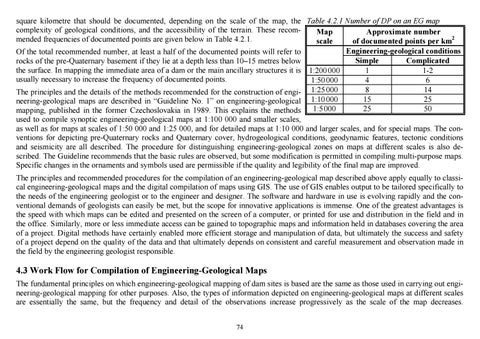
square kilometre that should be documented, depending on the scale of the map, the Table 4.2.1 Number of DP on an EG map complexity of geological conditions, and the accessibility of the terrain. These recomMap Approximate number mended frequencies of documented points are given below in Table 4.2.1. scale of documented points per km2 Engineering-geological conditions Of the total recommended number, at least a half of the documented points will refer to Simple Complicated rocks of the pre-Quaternary basement if they lie at a depth less than 10–15 metres below the surface. In mapping the immediate area of a dam or the main ancillary structures it is 1:200 000 1 1-2 usually necessary to increase the frequency of documented points. 1:50 000 4 6 8 14 The principles and the details of the methods recommended for the construction of engi- 1:25 000 15 25 neering-geological maps are described in “Guideline No. 1” on engineering-geological 1:10 000 1:5 000 25 50 mapping, published in the former Czechoslovakia in 1989. This explains the methods used to compile synoptic engineering-geological maps at 1:100 000 and smaller scales, as well as for maps at scales of 1:50 000 and 1:25 000, and for detailed maps at 1:10 000 and larger scales, and for special maps. The conventions for depicting pre-Quaternary rocks and Quaternary cover, hydrogeological conditions, geodynamic features, tectonic conditions and seismicity are all described. The procedure for distinguishing engineering-geological zones on maps at different scales is also described. The Guideline recommends that the basic rules are observed, but some modification is permitted in compiling multi-purpose maps. Specific changes in the ornaments and symbols used are permissible if the quality and legibility of the final map are improved. The principles and recommended procedures for the compilation of an engineering-geological map described above apply equally to classical engineering-geological maps and the digital compilation of maps using GIS. The use of GIS enables output to be tailored specifically to the needs of the engineering geologist or to the engineer and designer. The software and hardware in use is evolving rapidly and the conventional demands of geologists can easily be met, but the scope for innovative applications is immense. One of the greatest advantages is the speed with which maps can be edited and presented on the screen of a computer, or printed for use and distribution in the field and in the office. Similarly, more or less immediate access can be gained to topographic maps and information held in databases covering the area of a project. Digital methods have certainly enabled more efficient storage and manipulation of data, but ultimately the success and safety of a project depend on the quality of the data and that ultimately depends on consistent and careful measurement and observation made in the field by the engineering geologist responsible.
4.3 Work Flow for Compilation of Engineering-Geological Maps The fundamental principles on which engineering-geological mapping of dam sites is based are the same as those used in carrying out engineering-geological mapping for other purposes. Also, the types of information depicted on engineering-geological maps at different scales are essentially the same, but the frequency and detail of the observations increase progressively as the scale of the map decreases. 74 Ukázka elektronické knihy, UID: KOS206222
Nevertheless, because of the specific requirements for information determined by the different stages of development of a dam project, the work flow should follow a definite plan (Bůžková, et al., 1964). The compilation of engineering-geological maps can be divided into four basic stages: preparatory work, fieldwork, laboratory work, and processing of results and compilation of an engineering-geological map at the appropriate scale. 4.3.1 Preparatory Work Preparatory work is undertaken prior to fieldwork on the selected site. The geologist contracted to make the engineering-geological map must first carry out a thorough evaluation of all available information relating to the geology, geomorphology and hydrogeology of the area of interest. The results of previous geological mapping are re-drawn on a topographic base of suitable scale, though not necessarily the same as that on which the new engineering-geological survey will be compiled. The important types of information obtained from archival sources that will be transferred to the new engineering-geological base map include the details of previous underground workings and subsurface exploration (e.g., drilling). In addition, the locations of documented points from older surveys will also be marked, together with previously identified groundwater springs, and exposures created by extraction of minerals or aggregate (quarries, borrow pits, sand pits, etc.). An integral part of this process of compilation is the creation of a database including all relevant information contained in archived technical reports and earlier publications. All available information on the geological formations and the physical and chemical properties of the rocks and waters in the area of interest are tabulated systematically. When the review of previous work is near completion, field trips will be made by the geologist in order to verify the features described in the earlier work. This reconnaissance also enables the geologist to become familiar with the topography and exposure across the area to be mapped. At this stage the basic criteria used to distinguish different rock types and formations will be established by reference to previous studies and by direct observation in the field. Account will be taken of published information about the geological age and the stratigraphic subdivision of the rocks in the area. Where the stratigraphic status and lithology of formations has been established as a result of detailed studies by experts of a national geological survey, it will be appropriate to use the existing classification, as far as possible. If doubts are raised about the identity of certain rock types, it will be necessary to consult with a specialist and to carry out petrographic studies that will provide an unambiguous answer for the purposes of the planned engineering-geological survey. In areas where the geology is particularly complicated, it is a useful procedure to make a representative collection of rocks from the area for reference purposes. For example, when carrying out the survey for the Centro Cuba PSHEP, the teams of geologists, with the exception of the chief manager, were changed several times. The reference collection of rock types enabled the new team to begin with a clearly established understanding of the different rocks in the project area and to use the same criteria for identifying and naming them in the field. This enabled the new team to proceed smoothly with the survey and to construct a number of geological cross-sections that were verified by a preliminary geophysical survey.
75 Ukázka elektronické knihy, UID: KOS206222
Preparatory work ends with the submission of the plan for systematic engineering-geological mapping that will then be carried out. The amount of survey work to be undertaken in the field will be estimated, together with the preliminary numbers of field and laboratory tests of soils, rocks and water, etc., and the profiles designated for geophysical surveys. The final scope of the work will be determined as fieldwork progresses, depending on the feedback obtained as the results of observations and test measurements are progressively compiled. The plan of work must define the extent of the area to be mapped, bearing in mind that the limits will extend well beyond the footprint of the backwater area of the reservoir. This is because the engineering-geological map must take account of the impact that construction work will have not only on the stability of the natural environment. For instance, large fossil slope failures can be reactivated and new instabilities created because of changes in the groundwater regime, saturation or suffosion, etc. Also it is sometimes necessary to increase the mapped area to include the outcrops of rocks near the construction site that could be used for construction material or to provide additional information on which plans for recreational developments in the vicinity of the water reservoir can be based. In certain types of terrain, notably in karst regions and in regions where there are significant thicknesses of permeable rocks, the scope of the map must also be extended to include the area affected by seepage of water from the reservoir into the surrounding formations, and to include neighbouring streams if there is a likelihood of hydraulic communication between them. In the plan for mapping work, the scale of the map will be defined. This is mostly determined by the scale of the most recent available topographic base map and by the complexity of the geology of the area. A scale of 1:5 000 is usually chosen, but a scale of 1:10 000 is appropriate in areas with simple geology. As a rule, these scales are suitable for compiling maps on which to base the design of the project and to complete a preliminary plan. Engineering-geological maps for more detailed purposes are compiled on topographic base maps of larger scale, but usually cover only selected parts of the area of interest. For example, the area covered by the profile of a dam would be mapped at a scale of 1:2 000 or 1:1 000. In the preparatory stage of work, as well as during field mapping, full use will be made of aerial and satellite images that enable the geomorphological features and areas of intense geodynamic activity to be mapped precisely. These will include ancient slope failures and active landslides, rock falls, debris flows, water saturated areas and actively eroding gullies, etc. The importance of preparatory work should never be underestimated. Inadequate preparation usually leads to inefficiency caused by lack of awareness of the scope of previous work so that unnecessary repetition and difficulties of interpretation could occur during mapping. Under the pressures imposed by the schedule of work, the geologist may then be reduced to making compromises that would not have been necessary if a careful preliminary assessment of the existing information and a full analysis of the problem had been made beforehand. Notwithstanding this important caveat, commercial pressures can place an engineering geologist in a position where the time and resources to make a full preliminary assessment are simply not available. For example, when the Czech team arrived on site to undertake the engineeringgeological survey for the Centro Cuba PSHEP, it was discovered that there was no basic geological map of the area. In such circumstances the success of the project depended on an immediate appraisal of the situation so that a strategic plan could be improvised using all the geological skills and experience that the team could offer.
76 UkĂĄzka elektronickĂŠ knihy, UID: KOS206222