mokuta
Yerta
FISH
MOUNTAIN
OUR COUNTRY
ACTIVE
RECOVER
RETURN
kuya
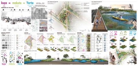
MEMORIES OF THE LAND
NEXT GENERATION PARKLAND
NEXT GENERATION PARKLAND
Man-made engineering in tandem with natural cycles to slowly rejuvenate the land.
STUDENT NAME: Kaige Xu STUDENT NUMBER: a1818023 EMAIL: xukaige@adelaide.edu.au
② Dry creek estuary ③ Bird habitat
Ecological acitivities zone
④ Sky Garden
Follow the memory of the land and inspire a cultural and ecological return.
⑤ Saltmarsh landscape path
SITE ELEMENT
Cultural acitivities zone
Agrarian Society
Industrial Zone
Military Factory
Post-Industrial
⑨ Green belt path ⑩ Residential centre
Community acitivities zone 537
There are too many bugs in the micro-environment habitat that I love to eat!
11 Pedestrian bridge
⑩
1980
There's also crabs and pipi!
⑧ Kaurna boating experience
⑨
Residential Area
Fishing is finally available around here!
I've learnt how Kaurna people hunting fish!
⑥ Kaurna hunting experience ⑦ Kaurna fishing experience
Outside water-flow Kaurna Land
In 2045, this will be an ecological and cultural traffic junction connecting the surrounding functional areas.
① Micro-environment Habitat
It's so rewarding to experience where Kaurna people travelled thousands of years ago by boating!
2023
⑤ ③
This bridge is not only passable by car, but also by bicycle!
1939
Inner water-flow
11
① ⑧ ⑦
TRANSPORTATION
It's full of fish that I love!
④
SITE ISSUE
⑥
Boating route
537
2014
1839
ECO-LINKS
1946
Figure 2B
Figure 1B
2023
HARNESS RACING CLUB
1939
DRY CREEK TRAIL
IMPASSABLE
Steep slopes of native vegetation
HABITAT LOSS Exposed loess
NEW ROAD CROSS TO DRY CREEK
IMPASSABLE Natural saltmaesh
DRY CREEK SALT FIELD
IMPASSABLE
Steep slopes of native vegetation
WASTELAND Site A
IMPASSABLE No sidewalk
HABITAT LOSS Exposed loess
KAURNA LAND
UNITED KINGDOM
WORLD WAR II
SALT FIELD
QUARRY
The Kaurna people have inhabited Salisbury for thousands of years, and at that time the land was not called Salisbury; it was an estuary for fishing and access to natural resources for the Kaurna people.
John Harvey, an English immigrant to South Australia in 1839, purchased land in 1847, naming it Salisbury after his wife's hometown in England. The area thrived with agriculture and livestock.
After World War II began, the Australian Ministry of Munitions requisitioned Salisbury and Penfield lands for munitions depots, converting agricultural land to industrial use, notably the Salisbury Explosives Depot.
After WWII, military factories repurposed for armaments production became versatile production and processing plants, including the notable Salt Field in Dry Creek.
Dry Creek's salt flats, now defunct, are being transformed into a residential area with plans for 25,000 homes. The area is currently undergoing site restoration, with land use status transitioning from quarrying and mining.
Figure 4B
Figure 3B
RESIDENT
0
WETLAND
EXPOSED PIPES
DESIGN CONCEPT
ACTIVE
TEXTURE TACTIC
FUNCTIONAL ZONING
Wildlife
ATTRACTIVE PARKLAND
RETURN
CONNECTING PARK-SYSTEM
Management
ECOLOGICAL ZONING
CONNECTING WATER-SYSTEM
A. TERRAIN
FOREST
Bassinet Micro- Habitat
PLANT SPECIES
32%
B.WATER
FOREST
Vascular RIVER
Inner pathways
C.INDUSTRY
Watercourse
20%
RIVERSIDE
Rethink
WETLAND
Drive road
Exisiting site
2023 - Preparing to start construction
Linkage
Activity area set-up
2026 - Road building finish
Human & Wildlife 2029 - Landscape finish
Plants recover
Waterbody connection
2032 - Natural farming
Natural insulation
2033 - Paving Gradual Integration
2038 - Tall trees of sufficient height
LEGEND Net
F. HUNTING
Stabilise
Natural Farming (info resourse): Impact of Natural Farming Cropping System on Rural Households—Evidence From Solan District of Himachal Pradesh, India
wood chop
Pests
Wooden pathways
Mycelium Paving
Mycelium Paving
Natural Farming
Mycelium composite
water
water
water
wood chop
The carriers of these memories.
Artfully hand-painted these carriers.
MORAL
Conceptualising previous hand-drawn drawings
Artfully hand-painted these carriers.
POSSIBILITIES
Drive road
Analyse and discuss design possibilities
Micro-environment Habitat
water Water Level lower River channel wider
affic
y tr
hwa
Hig
water
0
300 Metres
Fertiliser
N
Seed of a plant
George wetland
CULTURAL & ECOLOGICAL & ACTIVITY AREAS
Dry Creek Residential Construction site commencement
Dry Creek Residential Construction preparation
Dry Creek Residential (info resourse): Dry Creek Salt Field PEPR Revision 4 v.1 Part 4 Sept 2020 9 September 2020 Figure 19-2: Future Land Uses
2040 - Function
ESTUARY
se Noimoke S
link two difference waterbody
Mawson lake
BRAINSTORMING
Tall tree growth
Construction
Every land on earth has their first and foremost memories and stories.
TEXTURE
Active zone
Outter pathways
Tall tree growth
Mycelium Paving
Degraded Paving
Elevation pathways
MATERIAL
WATERCOURSE
8%
Outter pathways
Knot
11%
Vegetation cover
Vegetation cover
Inner pathways
CARRITERS
WETLAND
ESTUARY
E. FISHING
Active zone
WATERCOURSE
Fish
LAND MEMORISATION
15%
Wooden pathways
Dry Creek Residential Construction site commencement
Elder smith
Estuary
Dry creek salt field
DUNES
D. LANDGUAGE
Salt microscopy
Respect
14% DUNES
Greenfields Wetland
8-10 m
Eucalyptus largiflorens
7-15 m
Acacia melanoxylon
10-20 m
Acacia cyperophylla
9-15 m
Casuarina pauper
8-10 m
Eucalyptus albopurpurea
10-15 m
Eucalyptus calcareana
10-15 m
Eucalyptus leucoxylon 'Rosea'
5-8 m
Acacia retinodes
2-14 m
Eucalyptus porosa
4-8 m
Eucalyptus dumosa
4-12 m
Eucalyptus ssp. megalocarpa
8-15 m
Grevillea striata
12-15 m
Eucalyptus oleosa ssp. oleosa
8-30 m
Eucalyptus leucoxylon ssp. leucoxylon
20-30 m
Eucalyptus camaldulensis var. obtusa
2-14 m
Eucalyptus polybractea
3-4 m
Callistemon 'Harkness'
3-4 m
Eucalyptus angulosa
8-15 m
Eucalyptus arenacea
2-5 m
Melaleuca decussata
5-7 m
Pittosporum var. microcarpa
0.4-0.6 m
Cyperus gunnii spp. gunnii
0.4-0.7m
Eleocharis acuta
0.6-1 m
Juncus continuus
0.7-1.2m
Schoenoplectus validus
0.3-1 m
Cyperus exaltatus
0.1-0.5 m
Carex gaudichaudiana
0.3-1.2 m
Bolboschoenus caldwellii
0.6-1.2m
Chorizandra enodis
0.5-1 m
Carex bichenoviana
0.5-1 m
Juncus subsecundus
0.5-1.3 m
Poa labillardieri
0.2-0.5 m
Lepidosperma carphoides
0.5-1.5 m
Chenopodium curvispicatum
0.2-1 m
Dodonaea baueri
0.3-1 m
Leucophyta brownii
1-3 m
Banksia spinulosa 'Honey Pots'
0.6-1 m
Amphipogon caricinus var. caricinus
0.5-1 m
Atriplex vesicaria
1-3 m
Xanthorrhoea ssp. semiplana
4-5 m
Santalum acuminatum
0.5-2 m
Xanthorrhoea australis
HABITAT Fivehorned Dung Beetle
35.21%
Transverse Ladybird
Australasian Bittern Record: 180
RETURN
SALTMARSH
ESTUARY
FISHING
FISH HUNTING
BIKE FRIENDLY
DEGRADED PATHWAY
BOATING
Victorian Artoria
ACTIVE Increase connectivity and functionality to improve site 'vitality'
kuya
Over time, a gradual cover of plants formed ‘habitats’ that attracted animal migrants.
mokuta
16.53%
Activities
Habitat
Activities
ACTIVE
Management
Engineering
RECOVER
Green cover
Water system
RETURN
SITE
MICRO-ENVIRONMENT HABITAT BIRD HABITAT
MYCELIUM BRICK
Smooth Pebble Crab
European Earwig
10.78% Giant Green Slant-Face
Rostratula australis
Hydraulically manufactured mycelium bricks with a lifespan of about 20 years, which can be used for paving.
PATHWAYS
COMPOST & WOODCHIPS MONITORING
Record: 18
It can attract insects and small microorganisms as a habitat as well as a source of nutrients for plants.
WALK WAYS
HABITAT
Still available for human users, but some parasitic plants have begun to attach. ADVENTURE
HABITAT
Fish habitat
Insect habitat
BIRD HABITAT
WATER STAGES BIRD FOOD
Ground Shield Bug
9.22%
Utetheisa pulchelloides
BIRD HABITAT
BIRD FOOD
FISH HABITAT
BIRD HABITAT
ATTRACTING
Zanda funerea whiteae Record: 15
Black Bush-Mosquito
Smooth Pebble Crab
6.98% Gastropod
Malurus cyaneus Record: 14
ACTIVE Vacant land
RECOVER Eco-hierarchy
2023
2030
RETURN Habitat
2045
WETLAND SYSTEM HABITAT Biodegradable material + Eco-material + Slope
Eastern Gambusia
4.67%
Southern Eagle Ray
Haliaeetus leucogaster Record: 13 PERVIOUS CONCRETE As a bridge deck, the structure is permeable to water, which helps with rainwater runoff and pooling.
Barcoo Grunter
Mountain Galaxias
3.99%
Grallina cyanoleuca Record: 11
Snapper
WATERFRONT PATH
MILD STEEL
Used as piers to support the bridge deck, it is low carbon and environmentally friendly.
SUBCATCHMENT The water that follows the terrain connecting the Green Field Wetland and the George Wetland is collected and purified and then discharged to the sea.
SEAGRASS BRICK The degraded trestle naturally widens the river channel, creating a mangrove area and lowering the river level.
BIRD HABITAT
Southern Eagle Ray
2.87%
Southern Velvetfish
FISH HABITAT
Little Pied Cormorant
Blue Warehou
ACTIVE Vacant land
1.66%
Hogna crispipes
Egretta novaehollandiae Record: 10
Harmonia conformis
Iridomyrmex purpureus
0.33%
Ommatoiulus moreleti
Rhipidura leucophrys Record: 9
UNDEGRADED PATHWAY
Residential
MEADOWS
SEAGRASS BRICK
Record: 11
In 2045, the site will ‘return’ to remember the original Kaurna cultural and natural ecosystem.
Habitat
Communities
Record: 127
OUR COUNTRY
Yerta
Wildlife
Engineering
Peregrine Falcon
SITE
RECOVER
Water system
Biodegradable material + Eco-tank
Monarch
SITE
SITE
Green cover
SITE
BIRD MIGRATIONS
FISH
MOUNTAIN
Communities
SITE
Elevation pathways
Contour
N
Metres
DEGRADED RAIN GARDENS
RECOVER WALKABLE PARKLAND
500
2023
RECOVER Eco-hierarchy
2030
RETURN Habitat
2045