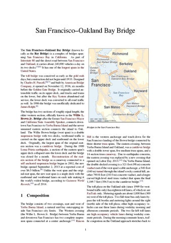
San Francisco–Oakland Bay Bridge The San Francisco–Oakland Bay Bridge (known locally as the Bay Bridge) is a complex of bridges spanning San Francisco Bay in California. As part of Interstate 80 and the direct road between San Francisco and Oakland, it carries about 240,000 vehicles a day on its two decks.[3][4] It has one of the longest spans in the United States.
Richmond RichmondSan Rafael Bridge
The toll bridge was conceived as early as the gold rush days, but construction did not begin until 1933. Designed by Charles H. Purcell,[6][7] and built by American Bridge Company, it opened on November 12, 1936, six months before the Golden Gate Bridge. It originally carried automobile traffic on its upper deck, and trucks and trains on the lower, but after the Key System abandoned rail service, the lower deck was converted to all-road traffic as well. In 1986 the bridge was unofficially dedicated to James Rolph.[8]
Oakland
San Francisco
San FranciscoOakland Bay Bridge
San Francisco Bay
San Mateo
The bridge has two sections of roughly equal length; the older western section, officially known as the Willie L. Brown Jr. Bridge after the former San Francisco Mayor and California State Assembly Speaker, connects downtown San Francisco to Yerba Buena Island and the newer unnamed eastern section connects the island to Oakland. The Willie Brown bridge (west span) is a double suspension bridge with two decks, westbound traffic is carried on the upper deck and eastbound on the lower deck. Originally, the largest span of the original eastern section was a cantilever bridge. During the 1989 Loma Prieta earthquake, a section of the eastern span’s upper deck collapsed onto the lower deck and the bridge was closed for a month. Reconstruction of the eastern section of the bridge as a causeway connected to a self-anchored suspension bridge began in 2002; the new bridge opened September 2, 2013 at a reported cost of over $6.5 billion.[9] Unlike the west span and the original east span, the new east span is a single deck with the eastbound and westbound lanes on each side making it the world’s widest bridge, according to Guinness World Records,[10] as of 2014.
1
Berkeley
Golden Gate Bridge
Hayward
San MateoHayward Bridge
Dumbarton Bridge 10 km
10 Miles
Bridges in the San Francisco Bay
Hill is the western anchorage and touch-down for the San Francisco landing of the Brown bridge connected by three shorter truss spans. The eastern crossing, between Yerba Buena Island and Oakland, was a cantilever bridge with a double-tower span, five medium truss spans, and a 14-section truss causeway. Due to earthquake concerns, the eastern crossing was replaced by a new crossing that opened on Labor Day 2013.[12] On Yerba Buena Island, the double-decked crossing is a 321-foot (98 m) concrete viaduct east of the west span’s cable anchorage, a 540-foot (160 m) tunnel through the island’s rocky central hill, another 790.8-foot (241.0 m) concrete viaduct, and a longer curved high-level steel truss viaduct that spans the final 1,169.7 feet (356.5 m) to the cantilever bridge.[13] The toll plaza on the Oakland side (since 1969 for westbound traffic only) has eighteen toll lanes, of which six are FasTrak-only. Metering signals are about 1,000 feet (300 m) west of the toll plaza. Two full-time bus-only lanes bypass the toll booths and metering lights around the right (north) side of the toll plaza; other high occupancy vehicles can use these lanes during weekday morning and afternoon commute periods. The two far-left toll lanes are high-occupancy vehicle lanes during weekday commute periods. During the morning commute hours, traffic congestion on the Oakland approach stretches back to
Composition
The bridge consists of two crossings, east and west of Yerba Buena Island, a natural mid-bay outcropping inside San Francisco city limits. The Western crossing (the Willie L. Brown Jr. Bridge) between Yerba Buena and downtown San Francisco has two complete suspension spans connected at a center anchorage.[11] Rincon 1
2
2
the three feeder highways, Interstate 580, Interstate 880, and Interstate 80 toward Richmond, California.[14] Since the number of lanes on the San Francisco approach is structurally restricted, backups are frequent in the eastbound direction during evening commute hours. The Willie Brown bridge portion of the bay bridge is currently restricted to motorized freeway traffic. Pedestrians, bicycles, and other non-freeway vehicles and devices are not allowed to cross this section. A project to add bicycle/pedestrian lanes to the western Brown span has been proposed but is not finalized. A California Department of Transportation (Caltrans) bicycle shuttle operates during peak commute hours for $1.00 each way.[15] Freeway ramps next to the tunnel provide access to Yerba Buena Island and Treasure Island. Because the toll plaza is on the Oakland side, traffic between the island and the main part of San Francisco can freely cross back and forth without paying a toll. Those who only travel from Oakland to Yerba Buena Island, and not the entire length to the main part of San Francisco, must pay the full toll.
2 2.1
HISTORY
The self-proclaimed Emperor Norton I saw fit to decree several times that a suspension bridge be constructed to connect Oakland with San Francisco. Later in 1872, frustrated that nothing had happened, Norton decreed: WHEREAS, we issued our decree ordering the citizens of San Francisco and Oakland to appropriate funds for the survey of a suspension bridge from Oakland Point via Goat Island; also for a tunnel; and to ascertain which is the best project; and whereas the said citizens have hitherto neglected to notice our said decree; and whereas we are determined our authority shall be fully respected; now, therefore, we do hereby command the arrest by the army of both the Boards of City Fathers if they persist in neglecting our decrees. Given under our royal hand and seal at San Francisco, this 17th day of September, 1872.[17]
History Pre-construction
San Francisco, at the mouth of the bay, was perfectly placed to prosper during the California Gold Rush. Almost all goods not produced locally arrived by ship. But after the first transcontinental railroad was completed in May 1869 San Francisco was on the wrong side of the Bay, separated from the new rail link. The fear of many San Franciscans was that the city would lose its position as the regional center of trade. The concept of a bridge spanning the San Francisco Bay had been considered since the Gold Rush days. Several newspaper articles during the early 1870s discussed the idea. In early 1872, a “Bay Bridge Committee” was hard at work on plans to construct a railroad bridge. The April 1872 issue of the San Francisco Real Estate Circular contained an item about the committee:
The Bay Bridge Committee lately submitted its report to the Board of Supervisors, in which compromise with the Central Pacific was recommended; also the bridging of the bay at Ravenswood and the granting of railroad facilities at Mission Bay and on the water front. Wm. C. Ralston, ex-Mayor Selby and James Otis were on this committee. A daily newspaper attempts to account for the advice of these gentlemen to the city by hinting that they were afraid of the railroad company, and therefore made their recommendations to suit its interests.[16]
Sketch of the proposed “Rush San Francisco Trans-Bay Suspension Bridge” (1913)[18]
Unlike most of Emperor Norton’s eccentric ideas, his decree to build a bridge had wide public and political appeal. Yet, the task was too much of an engineering and economic challenge since the bay was too wide and too deep there. In 1921, over forty years after Norton’s death, a tunnel was considered, but it became clear that one would be inadequate for vehicular traffic.[19] Support for a transbay crossing finally grew in the 1920s with the increasing popularity and availability of the automobile. In 1929, the California Legislature established the California Toll Bridge Authority with the responsibility of connecting San Francisco and Alameda County with a bridge.[19] To make the bridge feasible, its route was chosen to pass through Yerba Buena Island (formerly known as Goat Island in the 1870s), reducing the material and labor needed. Yerba Buena Island was a U.S. Navy base at the time (and until 1997).[20] So the approval of the U.S. Congress, which regulates the armed services and supervises all naval and military bases, was necessary for this island to be used. After a great deal of lobbying, Califor-
2.3
Opening day
3
nia received Congressional approval to use the island on February 20, 1931.
2.2
Construction
Traveling through the westbound Yerba Buena tunnel
540 feet (160 m) long.[13] It is the largest diameter transportation bore tunnel in the world.[19]
The Bay Bridge under construction at Yerba Buena Island in 1935
The chief engineer was Ralph Modjeski, a PolishAmerican. Construction began on July 9, 1933.[21] Ultimately, twenty-four men would die constructing the bridge [22] The western span of the bridge between San Francisco and Yerba Buena Island presented an enormous engineering challenge. The bay was up to 100 feet (30 m) deep in places and the soil required new foundation-laying techniques.[19] A single main suspension span some 4,100 feet (1.2 km) in length was considered but rejected, as it would have required too much fill and reduced wharfage space at San Francisco, had less vertical clearance for shipping, and cost more than the design ultimately adopted.[23] The solution was to construct a massive concrete anchorage halfway between San Francisco and the island, and to build a main suspension span on each side of this central anchorage.[24]
Reminders of the long-gone bridge railway survive along the south side of the lower Yerba Buena Tunnel. These are the regularly spaced “deadman holes” along the wall, into which track workers could duck if a train came along. (The north side, which always carried only motor traffic, lacks these holes.)[27]
2.3 Opening day The bridge opened on November 12, 1936 at 12:30 p.m. In attendance were the former U.S. president Herbert Hoover, Senator William G. McAdoo, and the Governor of California, Frank Merriam. Governor Merriam opened the bridge by cutting gold chains across it with an acetylene cutting torch.[28] The San Francisco Chronicle report of November 13, 1936 read:
East of Yerba Buena Island, the bay to Oakland was spanned by a 10,176-foot (3.102 km) combination of double cantilever, five long-span through-trusses, and a truss causeway, forming the longest bridge of its kind at the time.[19] The cantilever section was longest in the nation and third-longest anywhere.[25] Much of the original eastern span is founded upon treated The illuminated bridge as seen from the Embarcadero (San Franwood. Because of the very deep mud on the bay bot- cisco). tom it was not practical to reach bedrock, although the lower levels of the mud are quite firm. Long wooden pilings were crafted from entire old-growth Douglas fir trees the greatest traffic jam in the history of which were driven through the soft mud to the firmer botS.F., a dozen old-fashioned New Year’s eves tom layers.[26] thrown into one – the biggest and most goodnatured crowd of tens of thousands ever to try and walk the streets and guide their autos on 2.2.1 Yerba Buena Tunnel them – This was the city last night, the night of the bridge opening with every auto owner in Connecting the two halves of the bridge is Yerba Buena the bay region, seemingly, trying to crowd his Tunnel, 76 feet (23 m) wide, 58 feet (18 m) high, and machine onto the great bridge.
4
2
HISTORY
Schematic drawing of the Bay Bridge
And those who tried to view the brilliantly lighted structure from the hilltops and also view the fireworks display were numbered also in the thousands. Every intersection in the city, particularly those near the San Francisco entrance to the bridge, was jammed with a slowly moving auto caravan. Every available policeman in the department was called to duty to aid in regulating the city’s greatest parade of autos. One of the greatest traffic congestions of the evening was at Fifth and Mission Streets, with downtown traffic and bridge-bound traffic snarled in an almost hopeless mass. To add to the confusion, traffic signals jammed and did not synchronize. Police reported that there was no lessening of the traffic over the bridge, all lanes being crowded with Oakland- or San-Franciscobound machines far into the night.
A double balanced cantilever bridge, five truss bridges, and two truss causeways that connected Yerba Buena Island to Oakland (demolished)
Bryant St for eastward traffic entering. There was an onramp to the upper deck on Rincon Hill from Fremont Street (that later became an off-ramp) and an off-ramp to First Street (later extended over First St to Fremont St). The lower deck ended at Essex and Harrison St; just southwest of there, the tracks of the bridge railway left the lower deck and curved northward into the elevated loop through the Transbay Terminal that was paved for buses after rail service ended.
Until the 1960s the upper deck (58 feet (18 m) wide between curbs) carried three lanes of traffic in each direction and was restricted to automobiles only.[19] Eastward view after freeways The lower deck carried three lanes of truck and auto traffi on the north side of the bridge.[19] In the 1950s traffic lights were added to set the direction of travel in the middle lane, but still with no divider. Two railroad tracks on the south half of the lower deck carried the electric commuter trains.[31] In 1958 the tracks were [19] The total cost was $77 million. Before opening the replaced with pavement, but the reconfiguration to what bridge was blessed by Cardinal Secretary of State Eugene the traffic is today didn't take place until 1963. [29] Cardinal Pacelli, later Pope Pius XII. Because it was in effect two bridges strung together, the western spans were The Federal highway on the bridge was originally a ranked the second and third largest suspension bridges. concurrency of U.S. Highway 40 and U.S. Highway 50. Only the George Washington Bridge had a longer span The bridge was re-designated as Interstate 80 in 1964, and the western ends of U.S. 40 and U.S. 50 are now in between towers. Silver Summit, Utah and West Sacramento, California, As part of the celebration a United States commemorarespectively. tive coin was produced by the San Francisco mint. A half dollar, the obverse portrays California’s symbol, the The off-ramps for Treasure Island and Yerba Buena Isgrizzly bear, while the reverse presents a picture of the land are unusual in that they are on the left-hand side both bridge spanning the bay. A total of 71,424 coins were in the eastbound and westbound directions. The eastbound off ramp presents an unusual hazard - drivers must sold, some from the bridge’s tollbooths.[30] slow within the normal traffic flow and move into a very short off-ramp that ends in a short radius turn left turn (a 2.3.1 Roadway plan 15 MPH advisory is posted). The turn has been further narrowed from its original design by the installation of The original western approach to (and exit from) the up- crash pads on the island side. Eastbound and westbound per deck of the bridge was a long ramp to Fifth, branch- on-ramps are on the usual right-hand side, but they do not ing to Harrison St for westward traffic off the bridge and have dedicated merge lanes; drivers must await a gap in
2.5
Later events
5
the traffic and then accelerate from a stop sign to traffic speeds in a short distance.
2.4
Rail service
In 1939 the San Francisco Transbay Terminal opened and electric commuter trains started running across the south side of the lower deck of the bridge. The terminal originally was supposed to open the same time as the Bay Bridge, but delays caused it to be postponed. The trains were handled by the Sacramento Northern Railroad, the East Bay Electric Lines and the Key System. Freight trains never used the bridge. The tracks left the lower deck in San Francisco just southwest of the end of 1st St. The tracks went over several streets on a ramp into the terminal. Trains could turn around on the loop back onto the bridge when finished unloading. The tracks left the lower deck in Oakland just after the bridge ended. The East Bay Electric Line tracks ran along Engineer Rd and over the Southern Pacific yard on trestles (some of it is still standing and visible from toll road ramps) onto the Oakland streets. The Sacramento Northern and Key System tracks went under the SP tracks through a tunnel (which is also still standing) and onto 40th St. Due to falling ridership, Sacramento Northern and East Bay Electric Lines service ended in 1941. After WWII, Key System ridership began to fall as well. Despite the vital role the railroad played, the last train went over the bridge in 1958. The tracks were removed and replaced with pavement on the Transbay Terminal ramps and Bay Bridge. The Key System handled buses over the bridge until 1960 when its successor, AC Transit, took over operations. It still handles service today. The “deadman holes” built for workmen to duck into when a train came still remain, as filling them in would be a waste of time and money. There have been several attempts to restore rail service on the bridge, but none have been successful.
A scenic view of the Bay Bridge from the Bank of America building.
Automobile traffic increased dramatically in the ensuing decades while the Key System declined, and in October 1963, the Bay Bridge was reconfigured with five lanes of westbound traffic on the upper deck and five lanes of eastbound traffic on the lower deck. The Key System originally planned to end train operations in 1948 when it replaced its streetcars with buses, but Caltrans did not approve of this. Trucks were allowed on both decks and the railroad was removed.[19] Owing to a lack of clearance for trucks through the upper-deck portion of the Yerba Buena tunnel, it was necessary to lower the elevation of the upper deck where it passes through the tunnel, and to correspondingly excavate to lower the elevation of the lower portion.[32] Additionally, the upper deck was retrofitted to handle the increased loads due to trucks, with understringers added and prestressing added to the bottom of the floor beams. This retrofit is still in place and is visible to Eastbound traffic.
2.5.2 1968 aircraft accident
2.5 2.5.1
Later events Modification to remove rail service
On February 11, 1968, a U.S. Navy training aircraft crashed into the cantilever span of the bridge, killing both reserve officers aboard. The T2V SeaStar, based at NAS Los Alamitos in southern California, was on a routine weekend mission and had just taken off in the fog from nearby NAS Alameda. The plane struck the bridge about 15 feet (5 m) above the upper deck roadway and then sank in the bay north of the bridge.[33] There were no injuries among the motorists on the bridge.[34] One of the truss sections of the bridges was replaced due to damage from the impact.[35]
2.5.3 Cable lighting
Daytime view of the Bay Bridge and San Francisco seen from Yerba Buena Island
The series of lights adorning the suspension cables was added in 1986 as part of the bridge’s 50th-anniversary celebration.[36]
6 2.5.4
3 EARTHQUAKE DAMAGE AND SUBSEQUENT UPGRADES Ship accident
In 2007 a container ship named the Cosco Busan (now the Hanjin Venezia) hit the bridge resulting in the Cosco Busan oil spill. 2.5.5
2013 public light show installation
On March 5, 2013, a public art installation called "The Bay Lights" was activated on the western span’s vertical cables. The installation was designed by artist Leo Villareal and consists of 25,000 LED lights originally scheduled to be on nightly display until March 2015.[37] However, on December 17, 2014 the non-profit Illuminate The Arts announced that it had raised the $4 million needed to make the lights permanent; the display was A collapsed section of roadway deck after the 1989 earthquake temporarily turned off starting in March 2015 in order to perform maintenance and install sturdier bulbs and then The bridge was closed for just over a month as construcre-lit on January 30, 2016.[38][39] tion crews repaired the section. It reopened on NovemIn order to reduce driver distractions, the privately funded ber 18 of that year. The lighter pavement of the replacedisplay is not visible to users of the bridge, only to dis- ment section is visible in aerial photographs, at the east tant observers. This lighting effort is intended to form end of the through-truss part of the bridge (37°49′08″N part of a larger project to “light the bay”[40] Villareal 122°20′39″W / 37.8189°N 122.3442°W). used various algorithms to generate patterns such as rainfall, reflections on water, bird flight, expanding rings, and others. Villareal’s patterns and transitions will be se- 3.1 Western span retrofitting quenced and their duration determined by computerized random number generator to make each viewing experi- The western suspension span has undergone extensive ence unique.[41] Owing to the efficiency of the LED sys- seismic retrofitting. During the retrofit, much of the tem the estimated operating cost is only US $15.00 per structural steel supporting the bridge deck was replaced while the bridge remained open to traffic. Engineers acnight. complished this by using methods similar to those employed on the Chicago Skyway reconstruction project.[43]
3
Earthquake damage and subsequent upgrades
A view of Bay Bridge lights from a pier next to the Ferry Building in San Francisco
During the evening of October 17, 1989, Loma Prieta earthquake, which measured 6.9 on the moment magnitude scale,[42] a 50-foot (15 m) section of the upper deck of the eastern truss portion of the bridge at Pier E9 collapsed onto the deck below, indirectly causing one death.
The entire bridge was fabricated using hot steel rivets, which are impossible to heat treat and so remain relatively soft. Analysis showed that these could fail by shearing under extreme stress. Therefore, at most locations each given rivet was removed by breaking off the head with a jack-hammer [rivet buster] and punching out the old rivet, the hole precision reamed and the old rivets replaced with heat-treated high-strength tensioncontrol [TC] bolts and nuts. Most bolts had domed heads placed facing traffic so they looked similar to the rivets that were removed.[Caltrans contract 04-0435U4, 19992004]. This work had to be performed with great care as the steel of the structure had for many years been painted with lead based paint, which had to be carefully removed and contained by workers with extensive protective gear. Most of the beams were originally constructed of two plate I-beams joined with lattices of flat strip or angle stock, depending upon structural requirements. These have all been reconstructed by replacing the riveted lattice elements with bolted steel plate and so converting the lattice beams into box beams. This replacement included adding face plates to the large diagonal beams joining the faces of the main towers, which now have an improved appearance when viewed from certain angles.
3.2
Eastern span replacement
7 decision was made to replace it. The replacement span underwent a series of design changes, both progressive and regressive, with increasing cost estimates and contractor bids. The final plan included a single-towered self-anchored suspension span starting at Yerba Buena island, leading to a long viaduct to the Oakland touchdown.
Obsolete hot riveted laced ties (left, eastern span) and bolted box beam retrofit (right, western span)
Separated and protected bicycle lanes are a visually prominent feature on the south side of the new east span. The bikeway will carry recreational and commuter cyclists between Oakland and Yerba Buena Island.. Until that time cyclists and pedestrians must turn around and return to Oakland. The original eastern cantilever span had firefighting dry standpipes installed. No firefighting dry or wet standpipes were designed for the eastern span replacement, although, the firefighting wet standpipes do exist on the original western suspension span visible on both the north-side upper and lower decks.
The original east span closed permanently to traffic on Diagonal box beams have been added to each bay of the August 28, 2013, and the replacement span opened for upper and lower decks of the western spans. These add traffic five days later.[44] stiffness to reduce side-to-side motion during an earthquake and reduce the probability of damage to the deck• Eastern span: original and replacement ing surfaces. • Some new construction (2004) Analysis showed that some massive concrete supports • Substantial progress (2011) could burst and crumble under likely stresses. In particular the western supports were extensively modified. First, • The completed replacement and the old bridge the location of existing reinforcing bar is determined us(2013) ing magnetic techniques. In areas between bars holes are drilled. Into these holes is inserted and glued an L-shaped • Rest of old and new bridge (June 2015) bar that protrudes 15 to 25 centimeters (6 to 10 inches). • Final appearance (est. 2016) This bar is retained in the hole with a high-strength epoxy adhesive. The entire surface of the structure is thus covered with closely spaced protrusions. A network of hor- 3.2.1 October 2009 eyebar crack, repair failure and izontal and vertical reinforcing bars is then attached to bridge closure these protrusions. Mold surface plates are then positioned to retain high-strength concrete, which is then pumped During the 2009 Labor Day weekend closure for a porinto the void. After removal of the formwork the sur- tion of the replacement, a major crack was found in an face appears similar to the original concrete. This tech- eyebar, significant enough to warrant bridge closure.[45] nique has been applied elsewhere throughout California Working in parallel with the retrofit, California Departto improve freeway overpass abutments and some over- ment of Transportation (Caltrans), and its contractors and pass central supports which have unconventional shapes. subcontractors, were able to design, engineer, fabricate, (Other techniques such as jacket and grout are applied to and install the pieces required to repair the bridge, desimple vertical posts; see the seismic retrofit article.) laying its planned opening by only 1 1 ⁄ hours. The re2
The western approaches have also been retrofitted in part, pair was not inspected by the Federal Highway Adminbut mostly these have been replaced with new construc- istration, who relied on state inspection reports to ensure safety guidelines were met.[46] tion of reinforced concrete. On October 27, 2009, during the evening commute, the steel crossbeam and two steel tie rods repaired over Labor 3.2 Eastern span replacement Day weekend[47] snapped off the Bay Bridge’s eastern span and fell to the upper deck.[48][49][50] The cause may Main article: Eastern span replacement of the San have been due to metal-on-metal vibration from bridge Francisco–Oakland Bay Bridge traffic and wind gusts of up to 55 miles per hour (90 km/h) causing failure of one rod which broke off, which For various reasons, the eastern span would have been then led to the metal section crashing down.[51] Three too expensive to retrofit compared to replacing it, so the vehicles were either struck by or hit the fallen debris,
8
4
though there were no injuries.[52][53][54][55] On November 1, Caltrans announced that the bridge would probably stay closed at least through the morning commute of Monday, November 2, after repairs performed during the weekend failed a stress test on Sunday.[56] BART and the Golden Gate Ferry systems added supplemental service to accommodate the increased passenger load during the bridge closure.[57] The bridge reopened to traffic on November 2, 2009.
NAME
There have been two recent campaigns to name all, or parts, of the Bay Bridge for Emperor Norton.[62]
4.1.1 2004
In November 2004, after a campaign by San Francisco Chronicle cartoonist Phil Frank, then-San Francisco District 3 Supervisor Aaron Peskin introduced a resolution to The pieces which broke off on October 27 were a saddle, the San Francisco Board of Supervisors calling for the en[52][58] crossbars, and two tension rods. tire two-bridge system, from San Francisco to Oakland, to be named for Emperor Norton.[63] On December 14, 2004, the Board approved a modified version of this resolution, calling for only “new additions” — i.e., the new eastern crossing — to be named “The The bridge was “unofficially dedicated” to James B. Emperor Norton Bridge”.[17] Neither the City of Oakland “Sunny Jim” Rolph, Jr.,[59] but this was not widely recog- nor Alameda County passed any similar resolution, so the nized until the bridge’s 50th-anniversary celebrations in effort went no further. 1986. The official name of the bridge for all functional purposes has always been the “San Francisco–Oakland Bay Bridge,” and, by most local people, it is referred to 4.1.2 2013 simply as “the Bay Bridge.”
4
Name
Rolph, a Mayor of San Francisco from 1912 to 1931, was the Governor of California at the time construction of the bridge began. He died in office on June 2, 1934, two years before the bridge opened, leaving the bridge to be named for him out of respect.[19] However, due to the opposition of Joseph R. Knowland, publisher of the Oakland Tribune at the time, recognition of Rolph was withheld. In 1932, with an inability to finance the bridge, Joseph R. Knowland, (a former US Congressman) travelled to Washington and helped to persuade President Herbert Hoover and the Reconstruction Finance Corporation to advance $62 million for the building of the bridge.
In June 2013, nine members of the California State Assembly, joined by two members of the California State Senate, introduced Assembly Concurrent Resolution No. 65 (ACR 65) to name the western crossing of the bridge for former California Assembly Speaker and former San Francisco Mayor Willie Brown.[64] A petition launched in July 2013 and drafted by John Ginn called for the western span of the bridge to be named for Emperor Norton. The petition attracted 500-plus signatures before closing in September 2013.[65]
A second, ongoing petition, drafted by John Lumea, was launched in August 2013, and — echoing Aaron PeA plaque honoring Rolph’s contribution originally was skin’s original 2004 resolution — calls for the entire twoplaced at the west end of the bridge in San Francisco, bridge system to be named for Emperor Norton. This then was moved to the corner of Fifth and Bryant Streets petition has received coverage from the San Francisco in 1986 and removed entirely by Caltrans in 2006. Bay Guardian,[66] SFist,[67] Laughing Squid,[68] and The Raw Story,[69] as well as from Mozilla and Netscape cofounder Jamie Zawinski.[70] It has 5,200-plus signatures 4.1 Emperor Norton naming campaigns as of 2016. In 1872, the San Francisco entrepreneur and eccentric Emperor Norton (c.1818-1880) issued three proclamations calling for the design and construction of a sus- 4.1.3 2014 pension bridge between San Francisco and Oakland via The state legislative resolution naming the western span Yerba Buena Island (formerly Goat Island).[60] A 1939 plaque honoring Emperor Norton for the original of the Bay Bridge the "Willie L. Brown, Jr., Bridge” in August 2013 and the Senate in idea for the Bay Bridge was commissioned by the frater- passed the Assembly [71] A ceremony was held on February September 2013. nal society E Clampus Vitus and initially was displayed 11, 2014, marking the resolution and the installation of at The Cliff House. In the late 1980s or early 1990s, the [72] signs on either end of the span. plaque was moved to the Transbay Terminal, the public transit and Greyhound bus depot at the west end of the The larger entity of which the western span is a part bridge in downtown San Francisco. When the terminal retains the separate and independent designation “San was closed in 2010, the plaque was placed in storage.[61] Francisco-Oakland Bay Bridge.”[59]
9
4.2
Alexander Zuckerman Bike Path
The pedestrian and bicycle route on the eastern span is formally named after Alexander Zuckerman, founding chair of the East Bay Bike Coalition.[73] This forms a transbay route for the San Francisco Bay Trail. The path does not connect to Treasure Island sidewalks.
5
Financing and tolls
When the Bay Bridge opened in 1936, the toll was 65 cents, collected in each direction.[36] Within months, the toll was lowered to 50 cents in order to compete with the ferry system, and finally to 25 cents since this was shown sufficient to pay off the original revenue bonds on schedule. As with other bridges of the era, passage was supposed to become free after completion of the repayment of the original bonds. In the interest of reducing the cost of collecting tolls and of building additional toll booths, all bridges in the Bay Area were converted to collect tolls in only one direction, with the toll amount collected doubled.
projects, the Bay Area Toll Authority again raised tolls on all Bay Area bridges (excluding the Golden Gate Bridge) in July 2010.[77] The toll rate for autos on other Bay Area bridges was increased to US$5, but in the Bay Bridge a variable pricing tolling scheme based on congestion was implemented. The Bay Bridge congestion pricing scheme charges a US$6 toll from 5 a.m. to 10 a.m. and 3 p.m. to 7 p.m., Monday through Friday. During weekends cars pay US$5. Carpools before the implementation were exempted but now they pay US$2.50, and the carpool toll discount is now also available only to drivers with FasTrak electronic toll devices. The toll remained at the previous toll of US$4 at all other times on weekdays.[78][79] The Bay Area Toll Authority reported that by October 2010 fewer users are driving during the peak hours and more vehicles are crossing the Bay Bridge before and after the 5-10 a.m. period in which the congestion toll goes into effect. Commute delays in the first six months dropped by an average of 15% compared with 2009.[80][81] For vehicles with more than two axles, the toll rate is US$5 per axle, regardless of the time of day.[82]
Tolls were subsequently raised to finance improvements to the bridge approaches, required to connect with new freeways, and to subsidize public transit in order to reduce the traffic over the bridge. Caltrans, the state highway transportation agency, maintains seven of the eight San Francisco Bay Area bridges. (The Golden Gate Bridge is owned and maintained by the 2007 Golden Gate Bridge, Highway and Transportation District.) The basic toll (for automobiles) on the seven state bridges was raised to $1 by Regional Measure 1, approved by Bay Area voters in 1988.[74] A $1 seismic retrofit surcharge was added in 1998 by the state legislature, originally for eight years, but since then extended to December 2037 (AB1171, October 2001).[75] On March 2, 2004, voters approved Regional Measure 2, raising the toll by another dollar to a total of $3. An additional dollar was added to the toll starting January 1, 2007, to cover cost overruns concerning the replacement of the eastern span. The Metropolitan Transportation Commission, a regional transportation agency, in its capacity as the Bay Area Toll Authority, administers RM1 and RM2 funds, a significant portion of which are allocated to public transit capital improvements and operating subsidies in the transportation corridors served by the bridges. Caltrans administers the “second dollar” seismic surcharge, and receives some of the MTC-administered funds to perform other maintenance work on the bridges. The Bay Area Toll Authority is made up of appointed officials put in place by various city and county governments, and is not subject to direct voter oversight.[76] Due to further funding shortages for seismic retrofit
6 See also • 49-Mile Scenic Drive • Bay Bridge Troll • Cosco Busan oil spill • Treasure Island Development
7 Notes [1] “National Register of Historic Places Registration Form” (PDF). National Park Service – USDoI. Retrieved July 28, 2012. [2] San Francisco-Oakland Bay Bridge Archived 1 November 2010 at WebCite [3] “Welcome to the Traffic Data Branch - 2012AADT link”. California Department of Transportation. Retrieved September 22, 2013.
10
[4] “Bridge Facts San Francisco-Oakland Bay Bridge”. Bay Area Toll Authority, 43.4 million toll-paid vehicles (86.8 million trips) annually. 2013. Retrieved September 14, 2013. [5] Staff (2009-03-13). “National Register Information System”. National Register of Historic Places. National Park Service. [6] “San Francisco Oakland Bay Bridge (West)". Structurae. Nicolas Janberg. May 12, 2006. Retrieved August 8, 2008. [7] “San Francisco Oakland Bay Bridge (East)". Structurae. Nicolas Janberg. February 28, 2007. Retrieved August 8, 2008. [8] 2008 Named Freeways, Highways, Structures and Other Appurtenances in California (PDF). California Department of Transportation. January 2009. p. 41. Archived from the original (PDF) on May 23, 2013. |first1= missing |last1= in Authors list (help) [9] “First Cars Cross SF-Oakland Bay Bridge’s New Span”. ABC News. Retrieved September 3, 2013. [10] “San Francisco-Oakland Bay Bridge wins Excellence in Structural Engineering honor”. Press releases (California Department of Transportation). September 15, 2014. [11] “San Francisco Oakland Bay Bridge”. Bay Bridge Public Information Office. September 8, 2009. Retrieved November 16, 2010. [12] “Self-Anchored Suspension (SAS) Span”. Caltrans. Archived from the original on November 1, 2010. Retrieved July 15, 2010. Anticipated Completion Date: late 2013 [13] “Yerba Buena Crossing (Contract No. 04-5) – As Built Drawings” Caltrans 2006 [14] “Rebounding Economy Prompts Rise in Freeway Congestion” (Press release). Metropolitan Transportation Commission. September 14, 2005. Archived from the original on November 1, 2010. Retrieved July 12, 2008. [15] “Caltrans District 4 Bicycle Resources”. California Department of Transportation. July 14, 2008. Archived from the original on November 1, 2010. Retrieved July 26, 2008. [16] “Complimentary to Selby, Ralston and Otis.”. San Francisco Real Estate Circular. April 1872. Archived from the original on November 1, 2010. Retrieved July 13, 2008. [17] Herel, Suzanne (December 15, 2004). “Emperor Norton’s name may yet span the bay”. San Francisco Chronicle (Hearst Communications). pp. A–1. Archived from the original on November 1, 2010. Retrieved July 12, 2008. [18] Crane, Lorin P. (April 1913). “Proposed Suspension Bridge Over San Francisco Bay”. Overland Monthly 61 (4): 375–77. [19] “The San Francisco–Oakland Bay Bridge Facts at a glance”. Caltrans toll bridge program. California Department of Transportation. Archived from the original on November 1, 2010. Retrieved July 12, 2008.
7 NOTES
[20] Nolte, Carl (May 7, 1997). “The Navy’s Last Detail”. San Francisco Chronicle (Hearst Communications Inc.). Retrieved August 8, 2008. [21] “Billions for Building”. TIME XXII (4) (New York: Time Inc.). July 24, 1933. ISSN 0040-781X. Retrieved December 17, 2008. [22] San Jose Mercury News, August 10, 2013, by Lisa Vorderbrueggen [23] Leboski, pp. 339–40 [24] “World’s Largest Bridge rest on sunken skyscrapers” Popular Science, February 1935 [25] Petroski, p. 340 [26] Reisner, p. 113 [27] San Francisco-Oakland Bay Bridge Lower Deck Eastbound Drive http://www.youtube.com/watch?v= f9Eo5-PpPVU&t=4m4s [28] “Two Bay Area Bridges”. US Department of Transportation. January 18, 2005. Archived from the original on November 1, 2010. Retrieved June 13, 2008. [29] “Caltrans Facts/Information”. Caltrans. Archived from the original on April 7, 2007. Retrieved February 4, 2007. [30] Bay Bridge Half Dollar [31] Ford, Robert S. Red Trains in the East Bay (1977) Interurbans Publications ISBN 978-0-916374-27-3 p.258 [32] Bernard McGloin, John (1978). San Francisco, the Story of a City. San Francisco (California): Presidio Press. ISBN 978-0-89141-045-4. Archived from the original on November 1, 2010. [33] “Jet Smashes Into Bay Span”. Lodi News-Sentinel. United Press International. February 12, 1968. p. 1. [34] “Bay Bridge rammed by Navy jet trainer”. Spokane Daily Chronicle. Associated Press. February 12, 1968. p. 2. [35] “The Battle of the Bay Bridge”. Check-Six.com. 2002. Archived from the original on November 1, 2010. Retrieved July 13, 2008. [36] “East Span News”. California Department of Transportation. May 2002. Archived from the original on November 1, 2010. Retrieved July 13, 2008. [37] Wollan, Malia (March 4, 2013). “Long-Overshadowed Bay Bridge Will Go From Drab Gray to Glowing”. The New York Times. [38] Egelko, Bob (December 17, 2014). “Bay Bridge light show will go on”. SF Gate. SF Chronicle. Archived from the original on December 31, 2014. Retrieved May 7, 2015. ...the nonprofit Illuminate the Arts announced Wednesday that it had raised the needed $4 million to reinstall the “Bay Lights” as a permanent fixture on the western end of the bridge. [39] Cuff, Denis (28 January 2016). “Bay Bridge light sculpture turns back on Saturday night”. Bay Area News Group. Retrieved 30 January 2016.
11
[40] The Bay Lights (thebaylights.org) [41] Bay Bridge light display dazzles San Francisco Includes video (following a too-long advertisement) [42] “Historic Earthquakes”. United States Geological Survey. January 25, 2008. Archived from the original on November 1, 2010. Retrieved July 13, 2008. [43] Ali Khan, Mohiuddin (August 12, 2014). Accelerated Bridge Construction: Best Practices and Techniques (1 ed.). Elsevier. p. 282. ISBN 9780124072244. Retrieved September 24, 2014. [44] Cabanatuan, Michael (September 13, 2013). “Bay Bridge eastern span opens”. San Francisco Chronicle. [45] DiGiacomo, Janet (September 6, 2009). “Officials: Crack may keep Bay Bridge closed past Tuesday”. San Francisco, California: CNN. Archived from the original on November 1, 2010. Retrieved September 6, 2009. [46] Dearen, Jason; Sudhin Thanawala (October 28, 2009). “Bay Bridge failure stirs fear, anger over new span”. San Francisco Examiner. Associated Press. Archived from the original on November 1, 2010. Retrieved November 1, 2010. [47] “Emergency repair and detour connection completed on Bay Bridge.”. Press Release (Bay Bridge Public Information Office). September 8, 2009. Archived from the original on November 1, 2010. Retrieved November 1, 2009. [48] Michael Cabanatuan; Jaxon Van Derbeken; Jill Tucker; Carolyn Jones (October 29, 2009). “Bridge parts couldn't take the wind”. San Francisco Chronicle. Archived from the original on November 1, 2010. [49] Bay Bridge Closed for Eyebar Assessment and Repair Caltrans. Retrieved October 29, 2009. Archived November 2, 2009, at the Wayback Machine. [50] photograph of bridge damage by commuter directly behind it Archived 1 November 2010 at WebCite [51] Bay Bridge closed indefinitely. KGO-TV−7 ABC7News. October 28, 2009, 9:33 pm. [52] Marshall, John; Leff, Lisa (October 28, 2009). “Tough commute likely after Bay Bridge rod snaps”. seattletimes.com (The Seattle Times). Associated Press. Retrieved June 16, 2015. [53] Jason Dearin; Sudhin Thanawala (October 28, 2009). “No estimate when Bay Bridge will open”. San Francisco Chronicle. Archived from the original on October 30, 2009. [54] Michael Cabanatuan; Justin Berton (October 28, 2009). “Bay Bridge closed after repair falls apart”. The San Francisco Chronicle. Archived from the original on November 1, 2010. [55] “Bay Bridge will remain closed for 'a few days’". Los Angeles Times. October 28, 2009. Archived from the original on October 29, 2009.
[56] Jones, Carolyn (November 2, 2009). “Bay Bridge stays closed”. San Francisco Chronicle. Archived from the original on November 1, 2010. [57] Denis Cuff; Janis Mara (October 28, 2009). “Extra ferry, BART trains planned for morning commute”. Contra Costa Times. Archived from the original on November 1, 2010. [58] KSBW Action News Sunrise (5-7am), October 28, 2009 [59] “Named Freeways, Highways,Structures and Other Appurtenances in California”, California Department of Transportation, 2013, p. 43. [60] The Emperor’s Bridge Campaign, “Emperor Norton’s Bridge Proclamations.” [61] The Emperor’s Bridge Campaign, “1939 Plaque.” Archived October 28, 2014, at the Wayback Machine. [62] The Emperor’s Bridge Campaign, “Naming Efforts.” Archived October 28, 2014, at the Wayback Machine. [63] Resolution in Support of the Emperor Norton Bridge, introduced to the San Francisco Board of Supervisors by District 3 Supervisor Aaron Peskin, 2004. Archived December 15, 2013, at the Wayback Machine. [64] California Legislature, 2013-14 Regular Session, Assembly Concurrent Resolution No. 65 – Relative to the Willie L. Brown, Jr. Bridge, June 12, 2013. [65] John Ginn, Name the San Francisco Bridge after Emperor Norton I, petition at thePetitionSite.com, July 2013. [66] Justin Slaughter, “Petition to name Bay Bridge after Emperor Norton gains 1,000 signatures”, San Francisco Bay Guardian, August 13, 2013. [67] Andrew Dalton, “Effort To Rename Bay Bridge After Emperor Norton Revived By Online Petition”, SFist, August 6, 2013. [68] EDW Lynch, “Petition Calls for San Francisco–Oakland Bay Bridge To Be Named After Emperor Norton”, Laughing Squid, August 7, 2013. [69] Eric Dolan, “Petition to name San Francisco’s Bay Bridge after Emperor Norton gains support”, The Raw Story, August 13, 2013. [70] Jamie Zawinski, “Emperor Norton Bridge, Second Try”, jwz.org, August 7, 2013. [71] Official California Legislative Information, “Documents associated with ACR 65,” Legislative Counsel of California. [72] “Behold the Willie L. Brown Jr. Bridge”. KQED News. Retrieved October 4, 2014. [73] “Bicycle Die-Hards Test Out Bay Bridge Bike Path”. NBC. 3 September 2013. Retrieved 26 October 2015. [74] Regional Measure 1 Toll Bridge Program. bata.mtc.ca.gov; Bay Area Toll Authority. Archived 1 November 2010 at WebCite
12
9
[75] Dutra, John (October 14, 2001). “AB 1171 Assembly Bill – Chaptered”. California State Assembly. Archived from the original on November 1, 2010. Retrieved August 7, 2008. [76] “About MTC”. Metropolitan Transportation Commission. October 15, 2009. Archived from the original on November 1, 2010. Retrieved October 15, 2009. [77] “Frequently Asked Toll Questions”. Bay Area Toll Authority. June 1, 2010. Archived from the original on November 1, 2010. Retrieved June 29, 2010. [78] “Toll Increase Information”. Bay Area Toll Authority. June 1, 2010. Archived from the original on November 1, 2010. Retrieved June 29, 2010. [79] Michael Cabanatuan (May 13, 2010). “Reminder: Bridge tolls go up July 1”. The San Francisco Chronicle. Retrieved January 21, 2011. [80] Michael Cabanatuan (January 12, 2011). “Conflicting findings on Bay Bridge congestion toll”. The San Francisco Chronicle. Retrieved January 21, 2011. [81] “Bay Bridge Traffic Decreases After Congestion Pricing”. ABC News San Francisco. January 12, 2011. Retrieved January 21, 2011. [82] “Toll Increase Information: Multi-Axle Vehicles”. Bay Area Toll Authority. July 1, 2012. Retrieved December 29, 2013.
8
References
EXTERNAL LINKS
• baybridgeinfo.org Site by Caltrans about all current construction on the bridge. • California Department of Transportation (Caltrans) official Bay Bridge site Books: • “San Francisco To Have World’s Greatest Bridge”, March 1931, Popular Science • “The Titan Of Bridges”, January 1933, Popular Mechanics • “Giant Switchboard Controls Lights on Longest Bridge” Popular Mechanics, January 1937 Media: • Building the San Francisco–Oakland Bay Bridge (1937 documentary) United States Steel movie documentary on the building of the Bay Bridge (YouTube video 17 minutes). • Film of the building of the San Francisco–Oakland Bay Bridge. • EarthCam San Francisco-Oakland Bay Bridge Construction time-lapse • Lower Deck Rail and Roadway Off Ramps, 1939, Dorothea Lange photo • San Francisco-Oakland Bay Bridge Construction Collection MSS 722. Special Collections & Archives, UC San Diego Library.
• “Findings and Recommendation For Completion of the Main Span of the San Francisco–Oakland Bay Bridge East Span Seismic Safety Project” (PDF). Toll Bridge Seismic Retrofit Program. California De- Other: partment of Transportation. December 8, 2004. • “Symphonies in Steel: Bay Bridge and the Golden Archived from the original (PDF) on June 25, 2008. Gate” at The Virtual Museum of the City of San Retrieved July 13, 2008. Francisco • Petroski, Henry. (1995). Engineers of Dreams: • “New Bay Bridge”. Archived from the original on Great Bridge Builders and the Spanning of America. August 19, 2007. New York: Alfred A. Knopf. ISBN 0-679-43939-0. • Reisner, Marc (1999). A Dangerous Place: California’s Unsettling Fate. Penguin Books. • Russell, Ron (March 17, 2004). “A Bridge Too Weak?". SF Weekly. Retrieved September 10, 2010. • San Francisco-Oakland Bay Bridge East Span Seismic Safety Project. Retrieved August 24, 2005.
9
External links
Official sites:
• San Francisco–Oakland Bay Bridge (New East Span) at Structurae • San Francisco–Oakland Bay Bridge (West Span) at Structurae • San Francisco–Oakland Bay Bridge (Old East Span) at Structurae • HAER CA-32 (scanned) Historic American Engineering Record (SFOBB), history to 1999, 322 pages. • Live Toll Prices for San Francisco–Oakland Bay Bridge
13
10 10.1
Text and image sources, contributors, and licenses Text
• San Francisco–Oakland Bay Bridge Source: https://en.wikipedia.org/wiki/San_Francisco%E2%80%93Oakland_Bay_Bridge?oldid= 718710314 Contributors: Magnus Manske, Mav, PierreAbbat, David spector, Patrick, Michael Hardy, Blacklite, Bcrowell, Delirium, Minesweeper, Pjamescowie, BRG, Jengod, Geary, Colin Marquardt, Phr, WhisperToMe, Marshman, Raul654, Dpbsmith, Cluth, Gentgeen, Dale Arnett, Chrism, Moncrief, Postdlf, Tualha, Goodralph, HaeB, Xanzzibar, Mattflaschen, Alan Liefting, Ancheta Wis, Alexwcovington, Jpo, DocWatson42, Rickscholz, Nichalp, Wighson, Ich, Michael Devore, Leonard G., Chinasaur, Nkocharh, Bobblewik, Hob, Telso, Beland, JoJan, Kaldari, Andyabides, Rdsmith4, Rlquall, Aaronrp, Defenestrate, Nick2588, Sam, Ianneub, Gerrit, Chmod007, D6, Freakofnurture, Imroy, Econrad, Rich Farmbrough, Sladen, Ranma9617, Gku, Xezbeth, Bender235, Zakj, Petersam, Szyslak, Chairboy, Tom, Cacophony, Mtruch, Viriditas, Cmdrjameson, Jhamby, Justinsomnia, WikiLeon, Larryv, RussBlau, Ral315, SPUI, Jason One, Alansohn, Polarscribe, Me at work, Atlant, Calton, Water Bottle, Fawcett5, MattWade, Mid, Jm51, Dschwen, Stephan Leeds, Grenavitar, Kleinheero, Dan100, Richard Weil, Anarcho hipster, Oleg Alexandrov, Japanese Searobin, Brycen, Bushytails, RHaworth, Tabletop, Ariamaki, GregorB, SDC, Zzyzx11, Wayward, Jon Harald Søby, Mandarax, TopazSun, Behdad, Elvey, Kbdank71, Dananderson, Saperaud~enwiki, Noirish, Koavf, Rogerd, BlueMoonlet, Rschen7754, Tawker, ScottJ, Brighterorange, Pacific Coast Highway, Ian Pitchford, RobertG, Shultzc, Ysangkok, NekoDaemon, Gparker, Brendan Moody, Gatekreeper, Brewdog, UkPaolo, YurikBot, Jonrock, Wester, Kniveton, Cliffb, NorCalHistory, Splash, Pigman, Epolk, Ikar.us, Gateman1997, Hydrargyrum, Nogood, Dake~enwiki, Mconst, Howcheng, R’son-W, Yoninah, Paul.h, Tony1, Tyczka, Joshuawein, Kkmurray, EvanYares, Pegship, Ke6jjj, Squib, Mike Dillon, GraemeL, Chrishmt0423, Nathan24601, FG42~enwiki, Eaefremov, NeilN, N Yo FACE, Cmglee, Breuwi, Vanka5, Jmchuff, SmackBot, Zebathon, Regara, Jeffreykopp, KnowledgeOfSelf, Hydrogen Iodide, Speight, Davewild, Tbonnie, Anastrophe, Lagringa, KelleyCook, ProveIt, Sirana, IstvanWolf, Gilliam, Hmains, Marc Kupper, Schmiteye, Chris the speller, Improbcat, Bluebot, Movementarian, Thumperward, Nbarth, Sparsefarce, DHN-bot~enwiki, Royboycrashfan, Trekphiler, Vasilken, OrphanBot, Backspace, LCDee, Sino408, Check-Six, Cybercobra, Mikokat, Lord Eru, Hank chapot, O RLY?, BiggKwell, Kkmd, Wikiklaas, Glacier109, Theblackgecko, AThing, John, Coastergeekperson04, Miles530, Minna Sora no Shita, Wickethewok, Gregorydavid, VerruckteDan, Rkmlai, GETONERD84, Fossa, Dicklyon, Zepheus, Jim856796, Levineps, Nonexistant User, Monkeythumpa, Joseph Solis in Australia, Tmangray, Highspeed, Courcelles, Godgundam10, Mapsax, Millbrooky, Marshaul, ShelfSkewed, Scottst, Clipper471, Basar, Qrc2006, Trentblase, Cydebot, Krakfly, Kozuch, Ebyabe, Omicronpersei8, Daniel Olsen, Rocket000, Joowwww, BurmaShaver, Wjackdunstan, Epbr123, Totensiebush, Wxstorm, Eco84, MrXow, Dgies, Nick Number, Cooljuno411, DeusMP, Dawnseeker2000, Edelmand, Thadius856, Abracadab, Edit Centric, Tjmayerinsf, Spencer, Yellowdesk, Daz 90, Crashj, NapoliRoma, Barek, Harrison V, Skomorokh, NE2, Albany NY, Canticle, Gil mnogueira, GGreeneVa, Denimadept, Mcnnr3, TheAllSeeingEye, BryanC, Appraiser, CTF83!, Jatkins, Skew-t, Froid, Catgut, Bradrules, Star wars 100, Edgecution, Beagel, Ilesoft, Megatronacepticon, Jerem43, MartinBot, Sawblade5, Ustye, Centpacrr, Uriel8, CommonsDelinker, Subman758, J.delanoy, Ken Shook, Bananasims, Borsi112, Keithkml, Ian.thomson, PC78, BrokenSphere, LordAnubisBOT, Aboutmovies, SteveChervitzTrutane, Fullmetal2887, Nwbeeson, Yayarea510, WinterSpw, Andy Marchbanks, Cs302b, Hugo999, Enderminh, Kelapstick, MackDieselX27, Lexein, Redwood57, Abberley2, Mike Cline, Mercurywoodrose, GimmeBot, Hqb, ElinorD, Lradrama, Clarince63, DennyColt, Brunton, Sanfranman59, Optigan13, Everything counts, Onore Baka Sama, Fizbin, Falcon8765, VanBuren, M.brandonclark, Dough4872, Jack Merridew, Mbz1, Joelsayre, Arbor to SJ, Colfer2, -Grover, Lightmouse, CodeTalker, Fratrep, Maralia, Fishnet37222, Joshschr, Pinkadelica, Treekids, Xnatedawgx, Jimmy Slade, VanishedUser sdu9aya9fs787sads, Goodshoped35110s, Martarius, Sfan00 IMG, ClueBot, Mariordo, Binksternet, Kennvido, The Thing That Should Not Be, Plastikspork, LuigiFan11, MusicaLucas, Mild Bill Hiccup, DrFO.Jr.Tn~enwiki, Blanchardb, Piledhigheranddeeper, Shustov, Bay Area Native, Excirial, Bchaosf, KennyAlvord, BOTarate, Thewellman, Stepheng3, InsaneRabge, AL2TB, ParaGreen13, Callinus, Andromedahpg, AlanM1, Robveget, Kbdankbot, Bgag, Addbot, Transpoman, Non-dropframe, Morriswa, CanadianLinuxUser, Jim10701, RoadieRich, Myheartinchile, Gail, HerculeBot, Legobot, Luckas-bot, Shannon1, MileyDavidA, Yobot, Bballlova99, Agnosticaphid, Deputyduck, Alexrk2, AnomieBOT, Galoubet, Materialscientist, Danno uk, Xqbot, JimVC3, Jlcjliaj, MarkWarren, GrouchoBot, Demunkid, B767-500, Curtyoung13, Jp1966, Phoenix1867, LucienBOT, Citation bot 1, Covertzed, FriscoKnight, Pinethicket, Metricmike, Alexanderbm, FoxBot, Jedi94, Trappist the monk, Train2104, Johnlumea, Dinamik-bot, ErikvanB, Mjdestroyerofworlds, Fastilysock, Arcadia616, Daxter106, JuanGut, DARTH SIDIOUS 2, RjwilmsiBot, Jackehammond, Beyond My Ken, EmausBot, Cricobr, John of Reading, Chevy111, WikitanvirBot, Aggerwalnitesh, NeilK, ZéroBot, H3llBot, Tystnaden, Wfrmsf, Erianna, Δ, Thegoodguy3221, Tim Zukas, Ego White Tray, Xyzzyavatar, 28bot, ClueBot NG, Tayregoodwin, Giggett, Metro realty, Brycecordry, Castncoot, Widr, Heat 22, JGkatz, BG19bot, Jay8g, Delster2, Wikih101, TBrandley, Barnabywoods, Jmcontra, Cyberbot II, EuroCarGT, Rjfischer photography, Dexbot, Zeeyanwiki, Cwobeel, Swbrotha100, Graphium, Epicgenius, Lupin Pooter 888, BreakfastJr, Magnolia677, Wethar555, ChristianSchd, Awliu2, Dell UC, Cswtwo, SwansonGallery, Mr. Smart LION, Monkbot, Colby Gleason, Vozul, Filedelinkerbot, Hum1969, Asdfnicole, Pimpinellus, Okinawa55, ChamithN, Techie2557, Izkala, ScrapIronIV, Agh1ermahgerd, JudgeRM, FHB7695 and Anonymous: 422
10.2
Images
• File:Bart-logo.svg Source: https://upload.wikimedia.org/wikipedia/commons/2/26/Bart-logo.svg License: Public domain Contributors: • vector data: http://www.bart.gov/docs/brochures/BART_BasicsEng_0909.pdf Original artist: Unknown<a href='//www.wikidata.org/ wiki/Q4233718' title='wikidata:Q4233718'><img alt='wikidata:Q4233718' src='https://upload.wikimedia.org/wikipedia/commons/ thumb/f/ff/Wikidata-logo.svg/20px-Wikidata-logo.svg.png' width='20' height='11' srcset='https://upload.wikimedia.org/wikipedia/ commons/thumb/f/ff/Wikidata-logo.svg/30px-Wikidata-logo.svg.png 1.5x, https://upload.wikimedia.org/wikipedia/commons/thumb/f/ ff/Wikidata-logo.svg/40px-Wikidata-logo.svg.png 2x' data-file-width='1050' data-file-height='590' /></a> • File:Bay_Bridge_Panorama_(2874181431).jpg Source: https://upload.wikimedia.org/wikipedia/commons/5/56/Bay_Bridge_ Panorama_%282874181431%29.jpg License: CC BY 2.0 Contributors: Bay Bridge Panorama Original artist: Daniel Ramirez from Honolulu, USA • File:Bay_Bridge_collapse_2.jpg Source: https://upload.wikimedia.org/wikipedia/commons/9/9d/Bay_Bridge_collapse_2.jpg License: Public domain Contributors: • http://pubs.usgs.gov/dds/dds-29/web_pages/bay_bridge.html Original artist: C.E. Meyer • File:Bay_bridge_sf.JPG Source: https://upload.wikimedia.org/wikipedia/commons/3/3c/Bay_bridge_sf.JPG License: CC BY-SA 3.0 Contributors: Own work Original artist: Wikih101
14
10
TEXT AND IMAGE SOURCES, CONTRIBUTORS, AND LICENSES
• File:BayareaUSGS.jpg Source: https://upload.wikimedia.org/wikipedia/commons/5/5c/BayareaUSGS.jpg License: Public domain Contributors: ? Original artist: ? • File:Baybridgelights.JPG Source: https://upload.wikimedia.org/wikipedia/commons/b/b5/Baybridgelights.JPG License: CC BY-SA 3.0 Contributors: Own work Original artist: Allan J. Cronin • File:California_92.svg Source: https://upload.wikimedia.org/wikipedia/commons/d/d1/California_92.svg License: Public domain Contributors: Made to the specifications of the 1971 Caltrans sign drawing (still in use). Uses the Roadgeek 2005 fonts. (United States law does not permit the copyrighting of typeface designs, and the fonts are meant to be copies of a U.S. Government-produced work anyway.) Original artist: SPUI • File:Commons-logo.svg Source: https://upload.wikimedia.org/wikipedia/en/4/4a/Commons-logo.svg License: CC-BY-SA-3.0 Contributors: ? Original artist: ? • File:Flag_of_Oakland,_California.svg Source: https://upload.wikimedia.org/wikipedia/commons/a/ad/Flag_of_Oakland%2C_ California.svg License: Public domain Contributors: Own work Original artist: Dyfsunctional • File:Folder_Hexagonal_Icon.svg Source: https://upload.wikimedia.org/wikipedia/en/4/48/Folder_Hexagonal_Icon.svg License: Cc-bysa-3.0 Contributors: ? Original artist: ? • File:I-80_(1957).svg Source: https://upload.wikimedia.org/wikipedia/commons/d/d9/I-80_%281957%29.svg License: Public domain Contributors: Federal Highway Administration Original artist: Fredddie • File:I-80_(CA).svg Source: https://upload.wikimedia.org/wikipedia/commons/3/34/I-80_%28CA%29.svg License: Public domain Contributors: Own work Original artist: O • File:Oakland_Bay_Bridge_from_Yerba_Buena_Island.jpg Source: https://upload.wikimedia.org/wikipedia/commons/6/6e/ Oakland_Bay_Bridge_from_Yerba_Buena_Island.jpg License: CC BY-SA 3.0 Contributors: The Cooper Collection of U.S. Railroad History (The uploader’s private collection) Original artist: Bruce C. Cooper (the uploader) • File:People_icon.svg Source: https://upload.wikimedia.org/wikipedia/commons/3/37/People_icon.svg License: CC0 Contributors: OpenClipart Original artist: OpenClipart • File:Portal-puzzle.svg Source: https://upload.wikimedia.org/wikipedia/en/f/fd/Portal-puzzle.svg License: Public domain Contributors: ? Original artist: ? • File:ProposedSanFranciscoBayBridge2.jpg Source: https://upload.wikimedia.org/wikipedia/commons/c/c6/ ProposedSanFranciscoBayBridge2.jpg License: Public domain Contributors: PDF of the April 1913 Overland Monthly Original artist: Mike Cline • File:Question_book-new.svg Source: https://upload.wikimedia.org/wikipedia/en/9/99/Question_book-new.svg License: Cc-by-sa-3.0 Contributors: Created from scratch in Adobe Illustrator. Based on Image:Question book.png created by User:Equazcion Original artist: Tkgd2007 • File:Red_pog.svg Source: https://upload.wikimedia.org/wikipedia/en/0/0c/Red_pog.svg License: Public domain Contributors: ? Original artist: ? • File:Relief_map_of_California.png Source: https://upload.wikimedia.org/wikipedia/commons/d/d0/Relief_map_of_California.png License: CC BY-SA 3.0 Contributors: File:USA California location map.svg for borders, rivers, lakes, coastline Original artist: Nzeemin • File:SF-Oakland-Bay-Bridge-Construction.jpg Source: https://upload.wikimedia.org/wikipedia/commons/b/bf/ SF-Oakland-Bay-Bridge-Construction.jpg License: Public domain Contributors: • http://gimp-savvy.com/cgi-bin/img.cgi?ailsnXgaK1FzBAY173 Original artist: ? • File:SFOakBrEastPartVEast.jpg Source: https://upload.wikimedia.org/wikipedia/commons/d/d0/SFOakBrEastPartVEast.jpg License: CC SA 1.0 Contributors: ? Original artist: ? • File:SF_From_Marin_Highlands3.jpg Source: https://upload.wikimedia.org/wikipedia/commons/d/da/SF_From_Marin_Highlands3. jpg License: Public domain Contributors: en:User:Paul.h Original artist: en:User:Paul.h • File:San_Francisco_-_Oakland_Bay_Bridge_At_Night.jpg Source: https://upload.wikimedia.org/wikipedia/commons/d/dc/San_ Francisco_-_Oakland_Bay_Bridge_At_Night.jpg License: CC BY-SA 3.0 Contributors: Own work Original artist: Robert Fischer (Rjfischer_photography) • File:San_Francisco_Bay_Bridges_map_en.svg Source: https://upload.wikimedia.org/wikipedia/commons/f/f2/San_Francisco_Bay_ Bridges_map_en.svg License: CC BY-SA 3.0 Contributors: • http://www.census.gov/geo/www/tiger Original artist: Alexander Karnstedt (Alexrk) • File:San_Francisco_Oakland_Bay_Bridge_Retrofit_4_(2-cropped_vs_3).jpg Source: https://upload.wikimedia.org/wikipedia/ commons/6/6d/San_Francisco_Oakland_Bay_Bridge_Retrofit_4_%282-cropped_vs_3%29.jpg License: CC SA 1.0 Contributors: en:User:Leonard G. Original artist: User:Optigan13 Based on en:User:Leonard G. • File:Seal_of_Oakland,_California.png Source: https://upload.wikimedia.org/wikipedia/commons/9/97/Seal_of_Oakland%2C_ California.png License: Public domain Contributors: City of Oakland Original artist: City of Oakland • File:Title_Sheet,_Index_to_Drawings_-_San_Francisco_Oakland_Bay_Bridge,_Spanning_San_Francisco_Bay,_San_ Francisco,_San_Francisco_County,_CA_HAER_CAL,38-SANFRA,141-_(sheet_1_of_20).png Source: https://upload.wikimedia. org/wikipedia/commons/7/7d/Title_Sheet%2C_Index_to_Drawings_-_San_Francisco_Oakland_Bay_Bridge%2C_Spanning_San_ Francisco_Bay%2C_San_Francisco%2C_San_Francisco_County%2C_CA_HAER_CAL%2C38-SANFRA%2C141-_%28sheet_1_ of_20%29.png License: Public domain Contributors: http://www.loc.gov/pictures/item/ca1352.sheet.00001a Original artist: Goodman, Zachary, creator • File:Yerba_Buena_Island_tunnel.jpg Source: https://upload.wikimedia.org/wikipedia/commons/9/91/Yerba_Buena_Island_tunnel. jpg License: CC BY-SA 2.0 Contributors: Flickr Original artist: Jacob Davies from Oakland, California, USA
10.3
10.3
Content license
Content license
• Creative Commons Attribution-Share Alike 3.0
15