
International Research Journal of Engineering and Technology (IRJET) e-ISSN: 2395-0056
Volume: 13 Issue: 02 | Feb 2026 www.irjet.net p-ISSN: 2395-0072
International Research Journal of Engineering and Technology (IRJET) e-ISSN: 2395-0056
Volume: 13 Issue: 02 | Feb 2026 www.irjet.net p-ISSN: 2395-0072
Kedari V. K.1 , Talekar Siddhesh Popat2 , Shirsikar Aayush Mahendra3, Mule Yash Nandkishor4
1Lecturer, Dept. of Information Technology, Jaihind Comprehensive Educational Institue’s Jaihind Polytechnic Kuran, Maharashtra, India 2, 3,4Final year Diploma Student, Jaihind Comprehensive Educational Institue’s Jaihind Polytechnic Kuran, Maharashtra, India
Abstract - The catastrophic effects of deforestation, which include climate change and other natural disasters, are a scourge on humanity. One of the main reasons for deforestation is human avarice, which leads to actions like clearing forests for agriculture andother uses bycutting down trees and allowing them to burn. A great deal of the planet's vegetation has been cut down as a consequence of these terrible activities, which threatens the survivalofmanyspecies of plants and animals. In order to prevent loggers fromcutting down trees, governments and other organizations take many steps, including monitoring loggers while they are in transit and arresting those responsible. Unfortunately, capturing loggers has shown to be an ineffective solution to the problem of deforestation. So, to prevent loggers and criminals from acting, we have implemented machine learning utilizing the Mobile Net neural network deep learning model. The program is designed to detect when loggers are active using a hidden camera in the forest. It then notifies forest officials and provides a location map so that the criminals can be caught in the act.
Key Words: Deep Learning, Mobile Net Neural Network, Location Map, Machine Learning, Deforestation.
With forest cover dwindling at an alarming rate, climate change intensifying, and human involvement with natural ecosystems on the rise, anti-logging and wildfire protection technologies are more crucial than ever. Deforestation createsa varietyofproblems, includingsoil erosion,increasedcarbonemissions,lossofbiodiversity,and habitat disruption due to illegal logging and uncontrolled forest fires. The climate, ecological balance, and local inhabitants'livesareallgreatlyimpactedbyforests.Manual patrolsanddelayedreporting,thebackboneoftraditional forest monitoring approaches, frequently fall short in expansive,isolated,ordenselyforestedregions.Authorities can react swiftly and limit damage with the help of an intelligentanti-loggingandwildfirepreventiontechnology thatdetectsillicitactivityandfireoutbreaksearlyon.Forthe sakeofenvironmentalpreservation,long-termclimateand humanlifeprotection,andsustainableforestmanagement, suchsystemsarecrucial.
The system employs a mix of machine learning, image processing, sensor networks, and the internet of thingstodetectillicitloggingandpossiblewildfiredangers. Environmental sensors installed in woodlands record informationincludingrelativehumidity,temperature,smoke density,noisepatterns,and vibrationsignalsproduced by chainsaws and other heavy machines. Drones and camera systemsrecordfootageandstillsofforestareasinrealtime. Inordertostandardizesensorvaluesandeliminatenoise, datapre-processingtechniquesareutilized.Importantsigns likearapidincreaseintemperature,ahighconcentrationof smoke,unusuallyhighorlowfrequenciesofsound,orthe presence of unauthorized people can be located using featureextractiontechniques.Normalforestconditionsare distinguishedfromsuspiciousactivitiesusingclassification and anomaly detection techniques. Early detection of anomalous patterns allows for prompt action by forest officialstopreventillicitloggingandcontrolwildfires.
Systems designed to prevent wildfires and antilogging operations employ linear regression to analyze trends and make predictions about continuous environmentalfactors.Firerisk,firespreadrate,andforest degradationtrendsaresomeofthedependentvariablesthat aremodelledinthismodel.Independentvariablesinclude weather conditions (such as temperature, humidity, and windspeed)andseasonalfactors.Linearregressionisuseful forpredictingwhenforestsaremostatdangerandwhere theyaremostsusceptiblebyexaminingenvironmentaland incident data from the past. Identifying patterns of deforestation overtime,calculatingthe likelihood offires, and bolstering prevention efforts are all areas where it shines.Environmentalauthoritiesareabletobetterallocate resources and devise proactive forest conservation programs with the use of linear regression, which offers obviousinsightsduetoitsinterpretabilityandsimplicity.
With Mobile Net, even devices with limited resourcesmayperformefficientandaccurateimage-based detection,makingitanessentialcomponentofthissystem.If you're looking for a lightweight convolutional neural network that can run in real-time on edge devices like cameras, drones, and embedded systems in forests, go no farther than Mobile Net. To automatically categorize scenarios as safe or dangerous, Mobile Net is trained on
International Research Journal of Engineering and Technology (IRJET) e-ISSN: 2395-0056
Volume: 13 Issue: 02 | Feb 2026 www.irjet.net p-ISSN: 2395-0072
picturesofforestlandscapes,patternsofsmokefromfires, flames, logging equipment, and human interference. Its depth wise separable convolutions optimize accuracy withoutsacrificingcomputational expense. Byeliminating the need for cloud processing and minimizing latency, MobileNetenablestheedge-based,real-timeidentification ofwildfirewarningindicatorsandillicitloggingoperations. Modern anti-logging and wildfire prevention systems can benefit greatly from Mobile Net's speed, low power consumption,andresilience,makingitanidealtoolforlargescaledeploymentinremoteforestsituations.
1] An accurate event detection technique for forest firepreventionwasdescribedbyVishalK.Singhetal.,andit isbasedonfuzzyrules.Toaccuratelyinferforestfiresusing fire indices, the proposed approach was evaluated for classificationandintensitydiscrimination.Bycomparingthe inference accuracy of four variables temperature, humidity, wind speed, and smoke the suggested fuzzy logic-basedapproachclassifierisabletoinfertheforestfire withanaccuracyofapproximately98.7percent.Forestfires can be accurately predicted and prevented using various combinations of smoke, wind speed, humidity, and temperature,accordingtothestudyandresults.
2] For the purpose of detecting forest fires, Burakkizilkaya et al. developed a framework that is both effective and energy-efficient. In contrast to previous research, this method combines scalar sensors with multimediasensorsthatusedeeplearningmodels;detection isthencarriedoutbyfusingdatafromseverallevelsofthe system's architecture. The use of edge computing in decision-making also improves communication efficiency. The suggested architecture makes advantage of both the precision and efficiency of scalar and multimedia sensors. The novel framework achieves a sustainable emergency surveillancesystembalancebetweenenergyefficiencyand detection accuracy through the development of a hierarchicalstructuredstructure.authorshowandanalyze thefindingsofthetestbedexperimentsandthesimulations inacomparativemanner.Thetrialresultsshowthatenergy efficiency improves by 29.94% (for up to 28.50 days). Furthermore, processing can be enabled on edge devices with the help of a new lightweight CNN model. The experimental results show that a 98.28% success rate is reached.Consideringallofthecurrentfiredetectionstudies, author’s method outperforms all of them in terms of accuracy, with the exception of the one in Reference [36]. author’s method's performance is comparable to that of a 22-layer deep convolutional neural network, even as Reference[36]utilizesGoogle'sownnetwork.Inthiswork, thelimitsofedgecomputingareconsideredalongsidethe existinglightweightarchitecturesinthetestsconductedfor comparison, as the existing methodologies fail to do so. Whenitcomestoaccuracy,thesuggestedmethodisonpar withthetoplightweightarchitectures.
3] Haolin Yang et al. report that wildfires have becomeamajorthreatinrecentdecades.Wildfirescanbe mitigated by early detection and monitoring. AI, model refinement, and training. Random Forest appears to outperformDenseNetandotherdeeplearningmodels.This islikelyduetoinadequatedeeplearningmodeltrainingand tuning.Thisresearchrevealedthattherecentlydeveloped method of mathematically constructing burn maps with multiple indices and refining them with an object identification model may produce accurate burn maps. It can'tyetproduceaccurateburnmapsevenwithpoordata quality due to interference and noise. Train the object detectionmodelandfine-tunethemathematicalprocedure toimprovethemethod'saccuracy,especiallyonlow-quality photographs.Wildfireforecastingneedsadditionalresearch. Afteridentifyingawildfire'sperimeter,itsproximitytothe edgeandflammabilitycanbeusedtodetermineitsspread. The Normalized Difference Vegetation Index (NDVI) is alreadyusedtodetermineperimeter,butitcouldalsoassess burningsusceptibility.Futureresearchcouldestimateburn severity accurately and reliably. As indicated, background noiseandotherdistractionsmightaffectdNBRmaps,making themunreliableforburnseverityassessment.
The second part of this paper examines the prior researchthatwasheldinhighregardasLitereatureSurvey. Section 3 provides a comprehensive description of the proposedmethodology,outliningthepathofaction.Tosum upthearticle,aconclusionisprovidedonthecurrentplan. Section5delvesintoprospectiveimprovements,whilePart 4examinestheexperimentalevaluation.
4] Lertsinsrubtavee Adisorn et al. In this article, author will discuss author’s personal experience with buildingandlaunchinganetworktomonitorfieldhazeand identifyforestfiresusingalow-costInternetofThings(IoT) sensor. A number of air pollution parameters can be retrieved from distant sensors using the SEA-HAZEMON platform.author’sCanarinsensornodesareuniqueamong platforms in that they are able to sustain themselves and continueoperatingactivelyinforestareasformorethana year. For the purpose of identifying forest fires as they occurredinrealtime,abasicmodelwasalsoutilized,which relies on PM2.5 and CO concentrations. Using satellite imageryanddatacollectedbytheforestfirecontrolagency during the height of the forest fire season, author tested author’s system's ability to accurately detect fires. author wereabletogetabove80%accuracywithauthor’smodel. Nevertheless, due to the low precision and recall levels, authordiscoveredafewfalsepositiveevents
5]Thecatastrophiceffectsofwildfires,assuggested byYIGITTUNCELetal.,mightlingerforyearsaftertheevent has passed. It is essential to take proactive measures to detectandpreventwildfiresinordertolessentheirimpact. Continuousmonitoringandimproveddetectionaccuracycan
International Research Journal of Engineering and Technology (IRJET) e-ISSN: 2395-0056
Volume: 13 Issue: 02 | Feb 2026 www.irjet.net p-ISSN: 2395-0072
beachievedusingsensorsuitessetnearthegridlines.These sensor suites need to be able to run independently. This researchintroducesanewself-sustainingCPSthatoptimally controls sensor sample rates to maximize both device longevity and the accuracy of wildfire detection. Using an open-source wildfire simulator and real-life datasets, the suggestedmethodisthoroughlytestedusingreinforcement learning.Ameticulouslycalibratedheuristicapproachisat least2.5timesslowerthanthesuggestedframework,which achievesanuptimeof89%andareactiontimeof2minutes, according to the simulation findings. Additionally, when contrastedwiththedailyenergyconsumptionofthesensor suite,thetrainedpolicynetworkconsumesaminuscule0.6 mJofenergy.Consequently,thesuggestedmethodpermits accurate, ongoing, and detailed wildfire surveillance. Deployingitinoutlyinglocationscouldgreatlyimprovethe efficiencyofwildfiredetectionandpreventionefforts.
6] According to Warit Phankrawee et al., author blendedthefiredatafromNASAFIRMSwith'Temperature, Humidity,Rainfall,andPressure'databymatchinglatitude andlongitudeusingKDTree,a convenientmethod forfast nearest-neighboridentification,duringdatapreprocessing. TheKDTreeiscreatedusingthe'lat,''long,'and'datetime' columns,whichlinknearbymeteorologicalstationstofire sites.MachinelearningwasconstructedusingtheExtratrees BAG L2 model for prediction. This model incorporates ExtraTrees, a dynamic variation of the random forest technique.Itexcelsatmakingandmergingdifferentdecision trees.Thiscontributestomorepreciseforecasts.Inorderto betteranticipateforestfiresintheThailandregion,author’s research shows that machine learning models work well. Theresultsprovideusefulinformationforcontrollingand preventingfires.
7] Because it is built entirely in Python, the innovative online deforestation monitoring system suggestedbyZhipanWangetal.candrasticallycutdownon development costs. Anyone, even those without technical training, can utilize their own high-resolution pictures to track deforestation using this technique. In addition, additionalareasofremotesensingapplicationdomainscan find new ideas in the architecture of this open-sourced system, and professionals can easily create similar online systemsbyeditingthesourcecode.Inadditiontoassisting withUNSustainableDevelopmentGoal13:ClimateAction, authorthinkOpenForestMonitorcanmakeabigsplashin thedeforestationdetectionresearchcommunity.
8]IoannisIoannidisetc.Forestfiresarebecoming an increasingly serious problem, therefore we need new waystokeepaneyeoutforthem,identifythem,andreact quickly.Usingamicroservicesarchitectureandcontainerbasedvirtualization,wehavepresentedaSmartForestFire MonitoringandDetectionSystemthroughoutthiswork.The system provides an efficient, scalable, and modular
framework that can operate in contexts with limited resourcesbyutilizingthesemoderntechnologies.
9]AFFSRPmodelwasintroducedbyXuanSunetal. following an unintentional forest fire. To begin, the combustiblestate,meteorologicalfactors,andtopographical conditions are the readily available forest fire affecting variables that have been identified based on pertinent research and real-world situations. The FFSPP model is subsequentlycreatedbymergingtheCAandWangZhengfei models. Also, using ML techniques, the FFSRP model can estimate the burned area. At last, to prove the model and approach, we use the Chinese TV show "3.29 Forest Fire" and a real-life fire dataset from Portugal's Montesinho National Forest Park. Compared to the fire behavior simulationmodelsdevelopedbyFarsiteandPrometheus,the suggested FFSPP model has a lower relative error. In addition,thesuggestedFFSRPmodeliscapableofproducing accurate predictions in situations involving small to medium-sizedfires.
10] Using 2020 and 2021 Sentinel-2 satellite imagery and ground-truth data, Mariam Alshehri et al. identifieddeforestedareasintheBrazilianAmazonjungle. The author trained a transformer-based network for DD usingthesedataanddevelopedabitemporaldeforestation dataset. The author performed an extensive search for hyperparameters, trying out several configurations until they found the ones that worked best for their goal. Accordingtotheauthor'sresearch,acolor-shiftedinfrared composite and cross-entropy loss with AdamW optimizer producedthebestoverallperformanceintermsofaccuracy andbalanceindetectingchangesinclass,withanaccuracyof 84.70%andarecallof84.53%,respectively.Bycomparing theirresultstothoseofpreviousstudiesinDD,theauthors concludethattransformer-basednetworkscanachievefar higheraccuracy.
11]Amultimodalframeworkforforestmonitoring was introduced by Maha Sliti et al., which combines fiber Bragggrating(FBG)sensornetworkswithunmannedaerial vehicle(UAV)-mounteddiffractionspectroscopy.Thedesign provides a supplementary view of tree physiology not possiblewitheitherground-basedorremotesensingalone byintegratingcanopy-levelreflectancewithin-stemstrain and temperature proxies. Georeferenced stress maps are createdbycombiningUAVandFBGdata,whichallowsfor earlier and more accurate identification and targeted management activities such precision watering, insect treatment,andselectivethinningbeforesymptomsshowup. Fromanoperationalstandpoint,UAVplatformsofferfast,asneededcoverageacrossvariedterrain,whileembeddedFBG arraysguaranteecontinuous,passive,multiplexedsensingin the tree canopy. The pipeline meets all of the demanding standards for accuracy and reliability, as shown by the simulationresultsrununderbothdailyandweather-related variations.
International Research Journal of Engineering and Technology (IRJET) e-ISSN: 2395-0056
Volume: 13 Issue: 02 | Feb 2026 www.irjet.net p-ISSN: 2395-0072
12]SugiChoietal.recommendedutilizingtheSwin TransformerastheMask-RCNNmodel'sbackbonenetwork toidentifywildfiresbetter.Thismodelsolvedtheproblemof traditionalwildfiredetectionsystemsfailingtodiscriminate fire from non-fire events by integrating clouds, mist, and chimney smoke. The Swin Transformer detected fire and non-fire situations better, the data showed. Based on the confusion matrix, the Swin Transformer decreased false positives for non-fire categories, with 95% cloud classificationaccuracyand97%mistclassificationaccuracy. ThemodeloutperformedResNet-50with85%accuracyfor chimneysmoke,whichissimilartowildfiresmoke.Despite lowsight,theSwinTransformerdetectedearly-stagefires with 79% smoke detection and 64% flame detection. Quantitative analysis employing mean Average Precision (mAP)criteriaconfirmedtheSwinTransformer'sdurability. The model surpassed ResNet-50 in bounding box identification and segmentation mAP@50 scores of 0.849 and0.842.Themodelalsoperformedbetterwithobjectsof differentsizes,withboundingboxdetectionmAP_S=0.166, M=0.494,andL=0.699.TheSwinTransformercandetect fire indications at varied scales, from microscopic smoke trailsandflamesthathelpdetectwildfiresearlyontolarger smokeplumesthatindicateamoreadvancedfire.
13]Followingabatteryofmachinelearning tests, the optimal model for forest/non-forest classification was determined by Giacomo Albamonte et al. We trained, assessed,andtestedbothclassicMLmethodsandDLones. WhileallofthemreachedanIntersectionoverUnion(IoU)of 89.36%, the FPN model that took vegetation indices into accountperformedthebest.Forthepurposeofmethodically organizingentitiesandinteractionsacrossseveraldomains, a custom ontology called SORSOntology was created to expand the capabilities of the framework. Created by merging and expanding upon preexisting ontologies, SORSOntologyfacilitateseasyretrievalofinformationwitha semanticframeworkfromacentralrepositoryofknowledge. Atask-basedevaluationwasusedtoevaluatetheontology.
14] The group headed by Shakti Kundu. Deforestation indications such as tree stumps, trunks, machinery,andhumanpresencecanbeefficientlyidentified bycombiningtheautonomousdecision-makingcapabilityof LangChain Agent with the robust object recognition framework of the YOLOv8 model. The algorithm's great backdropdetectionperformancedemonstratesitscapability to effectively manage extensive forested terrain. But the modelneedsfurtherworktogiveconsistentidentificationin varied environments because it fails miserably at recognizing smaller, less distinctive objects. Throughout manyepochs,themodel'strainingresultsshowedpromising tendencies toward reducing significant loss measures as train/box_loss,train/cls_loss,andtrain/dfl_lossdecreased consistently.Thesefindingsdemonstratethatlearningand development are possible throughout training under the model's guidance. Nonetheless, the model needs better
generalizing approaches, and the increasing trend in validation loss measures suggests overfitting is likely. To overcome these obstacles and improve the model's performance in the actual world, data augmentation techniques,morediversifieddatasets,andimprovedfeature extractionareemployed.
15] Using official CONAF ground-reported information, Cristian Vidal-Silva et al. present a new, comprehensive wildfire dataset for Chile spanning 1985–2024.Thedatasetalsoallowsforanalysisthatareuniqueto climatezones.Itispossible,forinstance,tocomparewildfire patternsinChileantownslocatedwithintheMediterranean zone to those in other parts of the world with similar climates. This provides a chance to evaluate policies on a global scale and conduct comparative modeling across landscapesthatarepronetofires.Thedatasetisthoroughly cleaned,validated,andstandardisedtoensureitisfulland reliable;thisiscrucialforresearchthatinvolvecomplexfire modeling and risk assessment. The following are some importanttakeawaysfromthisstudy:•Thedatasetgreatly enhancestheresourcesforinvestigatingthefrequency,size, humanimpact,andeconomiclossescausedbywildfiresin Chile,acountrythatismoreatriskfromthesedisastersasa resultofchangesinclimateandlanduse.•Fireprediction, riskmapping,andpolicyevaluationareamongofthemany machine learning, deep learning, and statistical modeling tasksthatcandirectlybenefitfromtheuseofstandardized variables and temporal aggregation [18]. • The dataset is useful for international comparison studies and adds to worldwideeffortstounderstandandreducewildfirerisks, therefore its scientific importance goes beyond national borders.
International Research Journal of Engineering and Technology (IRJET) e-ISSN: 2395-0056
Volume: 13 Issue: 02 | Feb 2026 www.irjet.net p-ISSN: 2395-0072
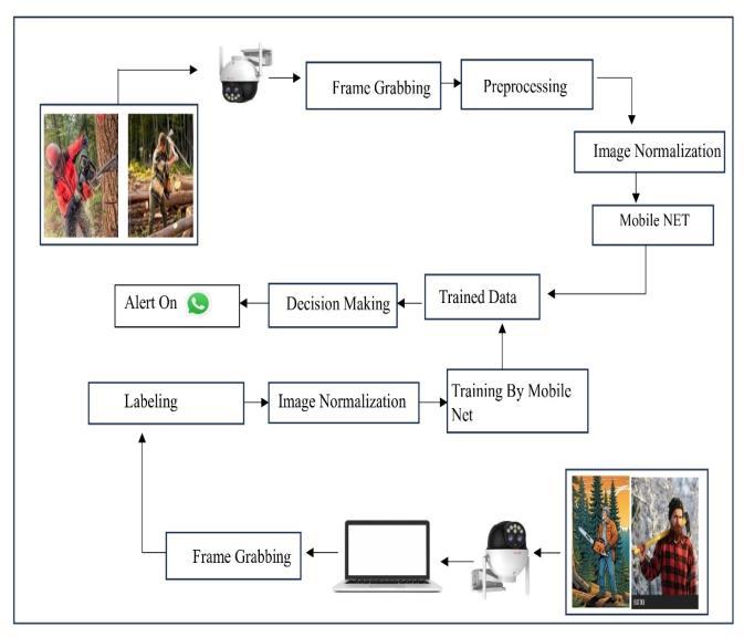
WhateachphaseofthesystemdiagramrepresentedforVAN RAKSHAK: Following these steps will describe an antiloggingandwildfirepreventionapproachfordeforestation
Step 1: Dataset Generator
Creating a dataset is to take images of the forest's many encroaching logging activities using OpenCV. The Video Capture method in the CV2 package takes pictures of the targetwildanimalssothattheycanbespottedwhentesting the model. The dataset folder contains all of the logging equipment. As the model evolves, it incorporates animal modelslikethechainsaw.Inpreparationforthenextmodel step,afolderismadetostorethecollectedloggingimages.
Step 2: Data Labelling
Thesecondstepisdatalabeling,whichentailsannotatingthe previouslycapturedphotosusingthelabelingprogram.Once theuserimportstheimageintothelabelingsoftware,they can specify the top right corner and bottom left corner coordinatestogeneratethex1,y1,andx2,y2ofthebottom right corner of the rectangle, respectively. The collected coordinatesaresavedinan.xmlfilesothatadeeplearning networknamedMobileNetcantrainthemodel.
Step 3: API Installation
ThisGoogleColabinstancerequirestheTensorFlowObject DetectionAPItobeinstalledbeforehand.Allyouneedisa copy of the [TensorFlow models repository] (https://github.com/tensorflow/models) and a few installationscripts.Pressingtheplaybuttonwillexecutethe following sections of code. The next step is to set up the conda environment so that we can download and extract cuDNNfiles.Then,grabthetensorflowmodelsprojectfrom GitHubandcloneit.ThenextstepwastoinstalltheObject DetectionAPI.
Step 4: Prepare Training Data and Upload Image Dataset
Uploadingthetrainingpicturesandrunningthescriptsfor TF Record generation are necessary steps to prepare the TensorFlowtrainingdata.Weneedtouploadourphotosand sortthemintoa"train,""validation,"and"test"folderbefore wecanrunthescriptsthatwillmakeTFRecordsfromour data.Firstthingsfirst,onourlocalPC,createasinglefolder called "images.zip" and zip all of our training images and XMLfilesintoit.Allofthefilesneedtobeinthezipfolder. We need to use a few commands to configure our picture directoriesandextractthecontentsafterit'suploaded.The /content subdirectory of the file system is where these foldersarecreatedinthisspecificcase.The"Files"iconon theleftallowsustonavigatethefilesystem.
Step 5: Divide the picture folders into test, validation, and train.
Youcanseethefoldericonontheleftsideofthescreen,and amongthelistedfiles,youcanfindour"images.zip"file.The following step, following dataset upload, is to extract its contentsandarrangethemintopicturefolders.The/content
subdirectory of the file system is where these folders are created in this specific case. The "Files" icon on the left allowsustonavigatethefilesystem.
Makingatrifectaoftheimages(train,validation,andtest)is thenextstage.Thefollowingisthefunctionofeveryset:To trainthemodel,theseexactphotographswereused.Afresh collection of images from the "train" set is input into the neural network at each training stage. After the network classifiestheobjectsinthephotos,itcanpredictwherethose objects are. The training algorithm calculates the loss and thenadjuststhenetworkweightsthroughbackpropagation. Training progress can be examined by modifying hyperparameters(likelearningrate)andimagesfromthe "validation"collectioncanbeusedbythetrainingalgorithm for validation. During training, these images are used less frequentlythanthe"train"images,whichareusedinevery phase.Theneuralnetworkistrainedindependentlyofthese photographsasatest.Ahumanshouldusethesetocheckthe model'saccuracyintheend.
Finally,weneedtoconverttheimagestoTFRecords,adata file format that TensorFlow uses for training. Python applicationsareusedtoautomaticallyconvertthedatainto TFRecordformat.Aclasslabelmaphastobesetupbefore wecanexecutethem.Byrunningthecodesectionbelow,you can create a "labelmap.txt" file that has a list of classes. Createanewlineforeachofourclassesandsubstitutethe words'class1','class2',and'class3'withthem.Next,launch thecodebypressingtheplaybutton.Indoingso,theobject detection model's detectable classes are stored in a "labelmap.txt"file.
In this section, we specify which TensorFlow 1 Object DetectionModelwewanttouseinitially.Allmodelscome with a configuration file. Training parameters, such as learningrateandtotalnumberofsteps,andfilelocationscan be set in this file, among other things. Changes are being madetotheconfigurationfileofourcustomtrainingjobat themoment.
Inthefirstportionofthecode,youcanseealistofmodels thatareavailableintheTF1ModelZoo.Then,you'llseethe namesofthefilesthatwillbeusedtodownloadthemodel andtheirconfiguration.Keepingtabsonthemodelswe're usingandaddingmoreasrequiredbecomesabreezewith this.In the "chosen_model" field, provide the name of the model that we wish to train with. At this point, the "ssdmobilenet-v1-quantized" model is chosen for implementation.Tospecifyanddownloadtheconfiguration file and pre-trained model file, proceed to the next three stagesandclickplay.
Once we have downloaded the model and configuration file, we need to add some general training
Volume: 13 Issue: 02 | Feb 2026 www.irjet.net p-ISSN: 2395-0072
parameterstothefile.Usingthefollowingvariables,wecan controlthedifferenttrainingstages:
Thetotalnumberofstepstoutilizewhentraining themodelisnum_steps.Foraninitialtarget,40,000stepsis asolidchoice.Ifweobservethatthelossmeasuresarestill fallingwhentrainingiscomplete,wecanapplyadditional steps.Ittakesmoretimetotrainiftherearemoresteps.If thelosslevelreachesthespecifiedpointbeforethetraining period ends, training can be terminated early. batch size:Thenumberofphotostoutilizeforeachtraining stage.Theamountofmemorythatcanbeusedfortraining onaGPUdeterminesthemaximumbatchsize,whichinturn reduces the number of steps needed to train a model. In most cases, 16 GPUs is an adequate amount for a Colab instance.
Quantization-aware training is the only one that uses quant_delay_steps. Following these extensive procedures, the training algorithm will simulate quantization by inserting"fake"quantizationnodesintothenetwork.Halfof the total training steps is a decent beginning point. [This article](https://neuralet.com/article/quantization-oftensorflow-object-detection-api-models/)hasmoredetails. In this step, we also assign other pieces of training information,suchasthetotalnumberofclasses,thelocation oftheconfigfile,andthelocationofthepre-trainedmodel file. Changing the configuration file is necessary to implement the newly defined training parameters. As its own"pipeline_file,"thiscodewillusethe.configfilethatyou obtained."config" with all the necessary parameters prepopulated.Inthemainpipelinefile,youmaycreateacustom configurationbyincludeourdataset,modelcheckpoint,and trainingparameters.Thefollowingblockdealswithupdating thetrainingscripttosavecheckpointsevery1000steps.Just tweak'num_eval_steps'tomakeitsavecheckpointsmoreor lessfrequently.Thedesignofthemobilenetworkisshown inFigure2.
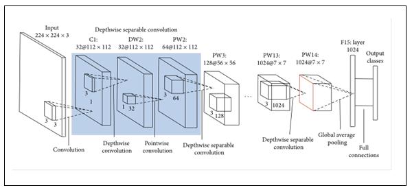
Figure 2: Mobile net Architecture
Step 8: Train Custom TF1 Object Detector
Wewilltrainourobjectdetectionmodelusingthe CustomTF1ObjectDetector.Thismodelistrainedusingthe "model_main_tf2.py" script that is part of the TF Object Detection API. We have defined all the arguments and
parametersusedby'model_main_tf2.py'inearlierportionsof this Collab. A training duration of 2–6 hours is possible, dependingonthemodel,batchsize,andnumberofstepsin thetrainingprocess.Thiswillbeusefullateron.Usingthe tflitefiletotestthemodelextensively.
Step 9: Testing the model for Tree Logging
Weputthemodelthroughitspacesfortreelogging: Here,thePythoncodemakesuseofthecameratocapture video and, by implication, the frames using the crossplatformDroidCamapp.Employingthelearnedmodelfile. Flite,theloggingequipmentcanbedetectedwithinthelive stream frames. When wedetecttreelogging activities, we immediatelyinformtherelevantauthorities.Theyarethen contactedbyWhatsAppandprovidedwithamapshowing thelocation,direction,andlandmarkofthecamera.
The Windows-based system, which has 16 GB of main memory and an Intel Core i7 processor, is used to implement the proposed model. The Anaconda IDE repositoryforSpyderandJupyterIDEsisusedbythemodel for the experiment. The created model is rigorously evaluatedusingtheparametersoftheconfusionmatrix.You may understand the parameters of the confusion matrix usingthefollowingequations:accuracy,precision,recall,and macroF1.
Accuracy=(TP+TN)/(TP+FP+TN+FN) -(1)
Precision(P)=TP/(TP+FN) -(2)
Recall(R)=TP/(TP+FP) -(3)
Macro-F1=(2*P*R)/(P+R) -(4)
Atthispoint,wehaveTPfortruepositives,TNfor true negatives, FP for false positives, and FN for false negatives.
Theobtainedresultsareshownbelow,
1.ConfusionMatrix
2.F1-ConfidenceCurve
3.PrecisionConfidenceCurve
4.Precision-recallCurve
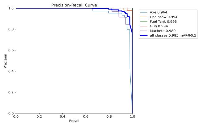
Figure 3: Precision–Recall (PR) Curve
International Research Journal of Engineering and Technology (IRJET) e-ISSN: 2395-0056
Volume: 13 Issue: 02 | Feb 2026 www.irjet.net p-ISSN: 2395-0072
The Precision–Recall curve illustrates the detection performanceofeachclass.Allclassesachievehighprecision and recall values, indicating accurate classification with minimal false positives and false negatives. The overall mAP@0.5 score is 0.985, showing excellent model performance.FuelTankandChainsawclassesachievenearperfect precisionvalues.Thecurveremainingcloseto the top-rightcornerindicatesstrongdetectionreliability.This graphconfirmstheeffectivenessofthetrainedYOLOmodel.
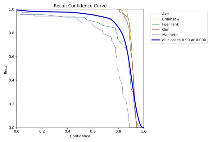
TheRecall–Confidencecurveshowshowrecallchangeswith varyingconfidencethresholds.Atlowerconfidencelevels, recall remains close to 1.0 for all classes. As confidence increases, recall gradually decreases, especially for the Machete class. The overall recall across all classes is approximately0.99atlowconfidence.Thisgraphhelpsin selectinganoptimalconfidencethresholdfordeployment.It demonstratesthetrade-offbetweendetectionsensitivityand confidencelevel.
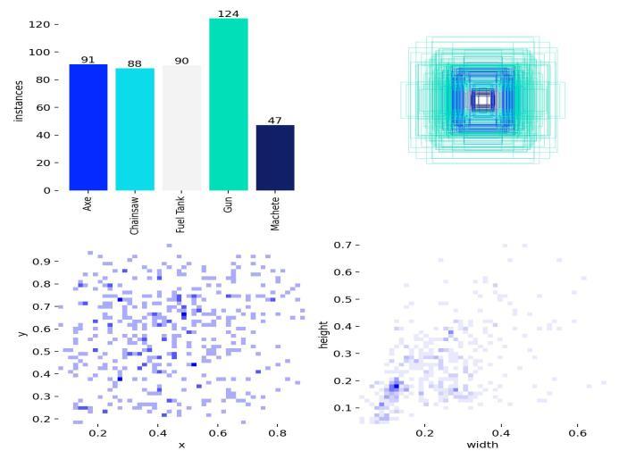
Thisgraphpresentstheclass-wisedistributionandspatial characteristicsofthedataset.Thebarchartshowsthatthe Gunclasshasthehighestnumberofinstances(124),while Machetehasthelowest(47).Thescatterplotsrepresentthe distributionofobjectcenter positions(x,y) andbounding boxwidth–heightvariations.Mostobjectsareconcentrated near the center of the images. The width–height plot indicates variation in object sizes, useful for model generalization. This analysis ensures dataset balance and diversity.
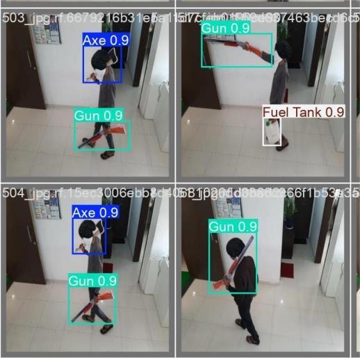
This figure shows sample output images from the trained objectdetectionmodel.Boundingboxesaredrawnaround detectedobjectssuchasAxe,Gun,Chainsaw,FuelTank,and Machete along with their confidence scores. The model successfullyidentifiesmultipleobjectsindifferentpositions andorientations.Highconfidencevalues(around0.8–0.9) indicate strong detection performance. This visualization confirmsthatthetrainedmodelcanaccuratelylocalizeand classify weapons in real-world scenarios. It also demonstratesrobustnessacrossdifferentframes.
Anintelligentanti-loggingandwildfireprotection systemcanstopdeforestation,accordingtothispaper.The growthinillegalloggingandforestfirescausedbyhuman carelessness and climate change has made the previous techniquesof monitoringthingsineffective. Theproposed system monitors forest regions in real time using cuttingedge technology to detect and respond to threats. By reducing manual surveillance and enhancing situational awareness,thetechnologyhelpspreserveforests,wildlife, andtheenvironment.
Data analysis and machine learning improve system efficiency and reliability. Linear regression models environmental variables including temperature, humidity,
International Research Journal of Engineering and Technology (IRJET) e-ISSN: 2395-0056
Volume: 13 Issue: 02 | Feb 2026 www.irjet.net p-ISSN: 2395-0072
andseasonalfluctuationstohelpauthoritiesidentifyharmful regionsandtimes.MobileNetimage-basedmonitoringlets edge devices with minimal capabilities identify wildfire indicators and illegal logging in real time. Overall, the recommendedtechniquetocontrolloggingandforestfires appearspromisingforlarge,susceptibleforests.Thesystem facilitates early intervention, environmental impact reduction, and data-driven decision-making to fight deforestation in a scalable way. The technology could improveforestpreservationandsustainableenvironmental management for decades with broad sensor integration, satellitedatafusion,andintelligentresponsecoordination. Future plans include a massive anti-logging and wildfire system. An enhancement of the system with real-time weather forecasting, drone surveillance, and satellite imagingcanimproveearlyalertsoverlargeforestregions. Advanced artificial intelligence models and ensemble learning can detect complex criminal activities and fire spreadpatternsindifferentenvironments.
Future advances include predictive models for long-term deforestation evaluation, automatic alarm systems connected to emergency services, and edge-cloud collaboration for faster response. Integration with GIS platforms and forest official mobile apps improves visualization and decision-making. Scalable deployment, sensors powered by renewable energy, and policy-driven analytics make the system a promising solution to sustainable forest protection and environmental conservation.
1]V.K.Singh,C.SinghandH.Raza,"EventClassificationand IntensityDiscriminationforForestFireInferenceWithIoT," in IEEE Sensors Journal, vol. 22, no. 9, pp. 8869-8880, 1 May1,2022,doi:10.1109/JSEN.2022.3163155.
2] B. Kizilkaya, E. Ever, H. Y. Yatbaz, and A. Yazici, "An Effective Forest Fire Detection Framework Using HeterogeneousWirelessMultimediaSensorNetworks,"ACM Trans.MultimediaComput.Commun.Appl.,vol.18,no.2,art. 47, May 2022. [Online]. Available: https://doi.org/10.1145/3473037.
3]H.Yang,"WildfireDetectionandPerimeterMappingusing Satellite Imagery and Machine Learning with Hyperopt Tuning," in CSSE 22: Proceedings of the 5th International ConferenceonComputerScienceandSoftwareEngineering, Guilin, China, Oct. 2022, pp. 497–505. doi: 10.1145/3569966.3570097.
4]A.Lertsinsrubtavee,K.G.S.Jayarathna,P.Mekbungwan,T. Kanabkaew, and S. Raksakietisak, "SEA-HAZEMON: Active Haze Monitoring and Forest Fire Detection Platform," in AINTEC '22: Proceedings of the 17th Asian Internet
Engineering Conference, Hiroshima, Japan, Dec. 2022, pp. 88–95.doi:10.1145/3570748.3570761.
5]Y.Tuncel,T.Basaklar,D.Carpenter-Graffy,andU.Ogras, "A Self-Sustained CPS Design for Reliable Wildfire Monitoring,"ACMTrans.Embedd.Comput.Syst.,vol.22,no. 5s, art. 135, pp. 1–23, Oct. 2023. [Online]. Available: https://doi.org/10.1145/3608100.
6]W.Phankrawee,N.Pornpholkullapat,T.Savanpopan,and S. Usanavasin, "Wildland and Forest Fire Prediction in ThailandusingSatelliteData,"inICISE23:Proceedingsofthe 20238thInternationalConferenceonInformationSystems Engineering,Bangkok,Thailand,Dec.2023,pp.159–163.doi: 10.1145/3641032.3641062.
7] Z. Wang et al., "A Web-Based Prototype System for DeforestationDetectiononHigh-ResolutionRemoteSensing Imagery With Deep Learning," IEEE Journal of Selected TopicsinAppliedEarthObservationsandRemoteSensing, vol. 17, pp. 18593-18606, 2024. doi: 10.1109/JSTARS.2024.3463360.
8]I.Ioannidis,A.Anagnostopoulos,andB.Mamalis,"Smart Forest Fire Monitoring and Detection System using Microservices and Container-based Virtualization," in PCI '24: Proceedings of the 28th Pan-Hellenic Conference on ProgressinComputingandInformatics,Egaleo,Greece,Dec. 2024,pp.368–375.doi:10.1145/3716554.3716610.
9] X. Sun et al., "A Forest Fire Prediction Model Based on CellularAutomata andMachineLearning,"inIEEEAccess, vol. 12, pp. 55389-55403, 2024, doi: 10.1109/ACCESS.2024.3389035.
10] M. Alshehri, A. Ouadou, and G. J. Scott, "Deep Transformer-BasedNetworkDeforestationDetectioninthe Brazilian Amazon Using Sentinel-2 Imagery," IEEE Geoscience and Remote Sensing Letters, vol. 21, pp. 1-5, 2024,Artno.2502705.doi:10.1109/LGRS.2024.3364952.
11]M.Sliti,A.Elfikky,A.I.Boghdady,S.A.H.MohsanandS. Ayouni,"IntegratingUAV-MountedDiffractionSpectroscopy and FBG Sensor Networks for Real-Time Forest Health Monitoring," in IEEE Access, vol. 13, pp. 196195-196205, 2025,doi:10.1109/ACCESS.2025.3628804.
12] S. Choi, Y. Song and H. Jung, "Study on Improving Detection Performance of Wildfire and Non-Fire Events EarlyUsingSwinTransformer,"inIEEEAccess,vol.13,pp. 46824-46837,2025,doi:10.1109/ACCESS.2025.3528983.
13] G. Albamonte, G. Falcone, M. Monaco, and S. Senatore, "Constructing a knowledge base from remote sensing indicators for deforestation assessment," Applied Intelligence, vol. 55, art. no. 1014, Oct. 2025. doi: 10.1007/s10489-025-06896-2.
International Research Journal of Engineering and Technology (IRJET) e-ISSN: 2395-0056
Volume: 13 Issue: 02 | Feb 2026 www.irjet.net p-ISSN: 2395-0072
14] S. Kundu et al., "Real-time deforestation anomaly detectionusingYOLOandLangChainagentsforsustainable environmentalmonitoring,"ScientificReports,vol.15,art. no.39961,2025.doi:10.1038/s41598-025-23617-4.
15] C. Vidal-Silva et al., "Wildfire Occurrence and Damage Dataset for Chile (1985–2024): A Real Data Resource for EarlyDetectionandPreventionSystems,"Data,vol.10,no.1, art.no.14,Jan.2025.doi:10.3390/data10010014.
2026, IRJET | Impact Factor value: 8.315 | ISO 9001:2008