
International Research Journal of Engineering and Technology (IRJET) e-ISSN: 2395-0056
Volume: 13 Issue: 03 | Mar 2026 www.irjet.net p-ISSN: 2395-0072

International Research Journal of Engineering and Technology (IRJET) e-ISSN: 2395-0056
Volume: 13 Issue: 03 | Mar 2026 www.irjet.net p-ISSN: 2395-0072
Shourya Gupta1 , Raj Shirdhankar2 , Aashay Kulkarni3 , Sanchit Dhage4 , Dolly Soni5 Department of Computer Engineering, Thakur Polytechnic, Kandivali East-400101
Abstract - Rapid urbanization has led to an increase in civic issues such as potholes, waste accumulation, and infrastructure damage, which significantly affect the quality of urban life. Traditional complaint management systems are often inefficient, lack real-time tracking, and require manual intervention. To address these challenges, this paper presents UrbanEye, an AIpowered urban issue mapping system that enables citizens to report and monitor civic problems through a mobile application.
The proposed system is developed using React Native for the frontend and Supabase for backend services, ensuring scalability and real-time data management. Users can report issues by uploading images, selecting categories, and providing location details, which are then processed and displayed on an interactive map. The system also includes features such as notifications, news updates, and a voucher- based reward mechanism to enhance user engagement. Additionally, an admin dashboard is provided for efficient monitoring and resolution of reported issues.
The results demonstrate that the system improves the efficiency of urban issue reporting and enhances communication between citizens and authorities. The integration of modern technologies such as cloud computing and optional AI-based classification makes UrbanEye a scalable and effective solution for smart city management.
Key Words: Smart City, CivicTech, Urban Issue Mapping, React Native, Supabase, Cloud Computing, GIS, Mobile Application, AI, Issue Reporting
The Rapid urbanization has led to a significant increase in civic issues such as potholes, uncollected garbage, broken streetlights,anddamagedinfrastructure.[1][4]Theseproblemsdirectlyaffectthequalityoflifeofcitizensandrequiretimely identification and resolution. However, existing complaint systems are often inefficient, lack real-time tracking, and involvemanualprocessesthatdelayaction.[1][2]
Withtheadvancementofsmartcitytechnologies andmobile computing, there is a growing need for an intelligent, userfriendly, and real-time urban issue reporting system. In this context, UrbanEye is proposedas anAI-powered civic issue mapper that enables citizens to report urban problems using a mobile application. The system allows users to capture images of issues, which are then analyzed using artificial intelligence to automatically categorize and describe the problem.[3]
UrbanEye integrates modern technologies such as React Native for mobile development, Supabase for backend services includingauthentication,database,andstorage,andAImodelsforimage-basedanalysis.Additionally,itprovides areal-timeadministrativedashboardforauthoritiestomonitor,manage,andresolvereportedissuesefficiently. The primary objective of this system is to bridge the gap between citizens and municipal authorities by providing a transparent, efficient, and scalable platform for urban issue management. By leveraging AI and real-time data, UrbanEye contributestowardsbuildingsmarter,cleaner,andmoreresponsivecities.
Several research works and existing systems have attempted to address urban issue reporting and smart city management using digital platforms. This section reviews relevant studies and highlights their limitations, which motivated the developmentofUrbanEye.
2.1
Existing government-based complaint systems such as municipal portals and mobile applications allow users to register complaints regarding civic issues. These systems provide basic functionalities like complaint submission and status tracking. However, they often lack real-time responsiveness, intuitive user interfaces, and intelligent categorization of issues.Additionally,manysystemsdependheavilyonmanualdataentry,whichreducesefficiencyandaccuracy.[1][2]
International Research Journal of Engineering and Technology (IRJET) e-ISSN: 2395-0056
Volume: 13 Issue: 03 | Mar 2026 www.irjet.net p-ISSN: 2395-0072
Geographic Information System (GIS) based solutions have been widely used for mapping and monitoring urban infrastructure. These systems help authorities visualize issues geographicallyand planresourceallocation.However, most GIS-based systems are complex, require expert handling,andare not directly accessible tocommoncitizens for real-time issuereporting.[4]
Recentresearchhasexploredtheuseofartificialintelligenceandcomputervisiontechniquesfordetectingurbanproblems such as potholes, garbage accumulation, and road damage. Convolutional Neural Networks (CNNs) and deep learning models have shown promising results in automated classification.[3] Despite their effectiveness, these systems are often limitedtoexperimentalenvironmentsandarenotintegratedintouser-friendlymobileapplications.
Severalmobileapplicationshavebeendevelopedtoincreasecitizen participation in governance by allowing users to report local issues. While these apps improve accessibility, they generally lack advanced features such as AI-based issue detection,real-timeanalytics,andcentralizeddashboardsforauthorities.Manyalsosufferfromlowscalabilityandpooruser engagement.[5][6]
Modern applications increasingly rely on cloud platforms for scalability, real-time databases, and authentication services. Technologies like backend-as-a-service (BaaS) simplify development and improve performance. However, many existing civic platforms do not fully utilize these capabilities to provide seamless real-time updates and efficient data management.[7][8]
2. PROPOSED SYSTEM
2.1 Proposed System
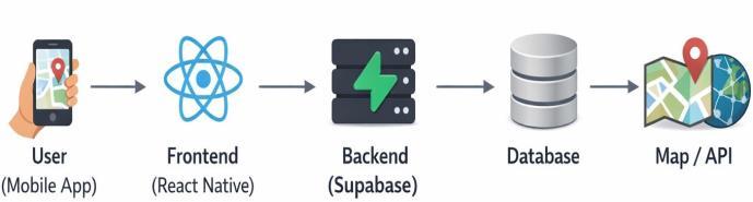
Theproposedsystem,UrbanEye,isanAI-poweredurbanissuemappingplatformdesignedtoenablecitizenstoreportcivic problems efficiently and assist authorities in resolving them through a centralized system.[3] The application leverages modernmobiletechnologies,cloud-basedbackendservices,andintelligentdatahandlingtoprovideaseamlessandreal-time experience.
The system allows users to report issues such as potholes, garbage accumulation, broken streetlights, and other infrastructure-relatedproblemsusingamobileapplication. Userscaneithermanuallyselecttheissuecategoryoruploadan image,whichcanbefurtherprocessedforintelligentclassification.
2.2 Key Features
The proposed system incorporates several important features that enhance usability, efficiency, and scalability. These featuresaredescribedasfollows:
2.2.1
TheapplicationisdevelopedusingReactNative,providingaclean,responsive,andintuitiveuserinterface.Itenablesusers toeasilyregister,login,reportissues,andtrackpreviouslysubmittedcomplaintswithoutanytechnicaldifficulty.
2.2.2
The system provides a structured and efficient mechanism for reporting civic issues. Users can perform the following actions:
International Research Journal of Engineering and Technology (IRJET) e-ISSN: 2395-0056
Volume: 13 Issue: 03 | Mar 2026 www.irjet.net p-ISSN: 2395-0072
Captureoruploadimagesoftheissue
Selecttheissuetype
Provideabriefdescriptionoftheproblem
Sharethelocationoftheissue
Submitthecomplaintinstantly
2.2.3 Real-Time Map Integration
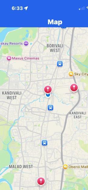
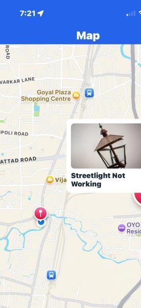
All reported issues are displayed on an interactive map interface. This feature allows both users and authorities to visualizetheexactgeographicallocationofproblems,improvingtransparencyandenablingfasterdecision-making.
3.2.4. Backend Integration (Cloud-Based)
ThesystemutilizesSupabaseasabackendservicetoensurescalabilityandreal-timeperformance.Itprovidesthefollowing functionalities:
Userauthenticationandsecurelogin
Real-timedatabaseforstoringissuedata
Cloudstorageforimagesandmediafiles
3.2.5. Admin Monitoring Dashboard
An administrative dashboard is provided for authorities to efficiently manage reported issues. Through this dashboard, administratorscan:
Viewallsubmittedcomplaints
Trackuseractivity
Monitorthestatusandresolutionprogressofissues
3.2.6. AI-Based Enhancement
To improve system intelligence, AI techniques have beenintegrated.Theseenhancementsinclude:
Automaticdetectionandclassificationofissuesfromimages
Improvedaccuracyinidentifyingproblemtypes
Reductioninmanualuserinput
2.3 Working of the System
Volume: 13 Issue: 03 | Mar 2026 www.irjet.net p-ISSN: 2395-0072
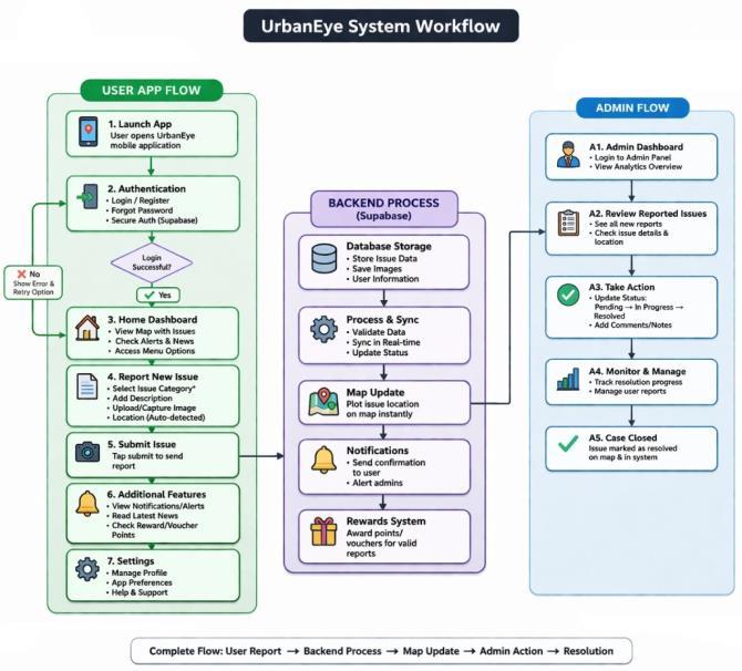
TheworkingofUrbanEyecanbedescribedinthefollowingsteps:
1.Theuserregistersandlogsintotheapplication.
2.Theuserreportsanissuebyselectingcategory,uploadinganimage,andaddingdetails.
3.Thesystemcapturesthelocationandstoresthedatainthedatabase.
4.Thereportedissueisdisplayedonthemapinreal-time.
5.Thesystemsendsalertsandupdatesrelatedtoreportedissues.
6.Userscanaccessnewsandmanagesettingswithintheapplication.
7.Admincanview,monitor,andtakeactiononreportedissues.
8.Thesystemmayprovidevouchersorrewardstoencourageuserparticipation.
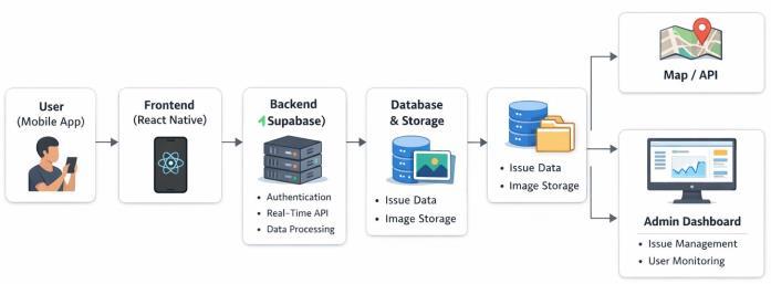
Thesystemarchitectureof UrbanEye isdesignedasamodularandscalablestructurethatintegratesamobileapplication, cloud-based backend, and real-time services. It follows a client-server architecture in which the user interacts with the mobileapplication,andalloperationssuchasdataprocessing,storage,andretrievalarehandledthroughbackendservices. Thisdesignensuresefficientcommunication,scalability,andreal-timeperformance.
The user interacts with the system through a mobile application developed using React Native. The application provides featuressuchasuserauthentication,issuereporting,mapvisualization,alerts,and settingsmanagement.Thefrontendis responsibleforhandlingthe userinterfaceanduserexperience,capturinginputssuchasimages,location,andissuedetails, andtransmittingthisdatatothebackendthroughAPIs.
The backend of the system is powered by Supabase, which provides essential services including secure authentication, communication,and real-timedata synchronization.[7] Itprocesses thedata receivedfromthefrontend,validatesit,and ensuresseamlessinteractionbetweendifferentcomponentsofthesystem.
Alldata,includinguserinformation,issuedetails,andstatusupdates,arestoredinacloud-baseddatabase.[7]Additionally, cloudstorageis used tostoreimages uploaded byusers. This enables efficient data management, quick access, and reliable storageoflargemediafiles.
Mapservicesareintegratedintothesystemtodisplayreportedissuesgeographically.TheseservicesuseAPIstofetchand updatereal-timelocation-baseddata,allowingusersandadministratorstovisualizeissueseffectivelyonaninteractivemap.
Furthermore,anadminmoduleisincludedtoenableauthoritiestomonitorandmanagereportedissues.Throughtheadmin dashboard,administratorscanviewcomplaints,
tracktheirstatus,andtakenecessaryactionsforresolution,ensuringefficienturbanissuemanagement.
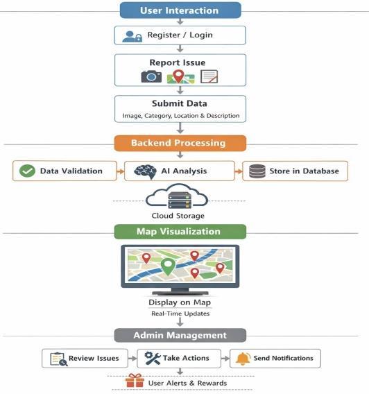
Themethodologyof UrbanEye isdesignedtoprovidea systematicapproachforreporting,processing,andmanagingurban issuesusingamobile-basedplatformintegratedwithcloudservices.Thesystemfollowsaclient-serverarchitecturewhere theuserinteractswiththemobileapplication,andalldataisprocessedandstoredthroughacentralizedbackend.
International Research Journal of Engineering and Technology (IRJET) e-ISSN: 2395-0056
Volume: 13 Issue: 03 | Mar 2026 www.irjet.net p-ISSN: 2395-0072
Initially, users interact with the application by registering and logging in securely. They can report civic issues by uploading images, selecting the issue category, adding a description, and sharing their location. This data is collected throughthefrontendandtransmittedtothebackendusingAPI-basedcommunication.
Thebackendsystemprocessesthereceiveddatabyvalidatinginputsandstoringtheminaclouddatabase.Ifimplemented, artificial intelligence techniques can be usedto analyze uploaded images and automatically classifythetype of issue.[3] All data,includingimagesanduserdetails,aresecurelystoredtoensureefficientmanagementandretrieval.
The processed informationisthenintegrated with map servicestoprovidereal-timevisualizationofreportedissues.Users canviewtheseissuesgeographically,whileadministratorscanmonitorthemthroughadedicateddashboard.Thesystem alsogeneratesnotificationstokeepusersupdatedaboutthestatusoftheircomplaints.
Finally, administrators review the reported issues, update their status, and take appropriate actions for resolution. Additional features such as alerts, news updates, and reward mechanisms (e.g., vouchers) enhance user engagement and encourageactiveparticipationinurbanissuereporting.
The implementation of UrbanEye is carried out using modern mobile and cloud technologies to ensure real-time performance and scalability.[7] The mobile application is developed using React Native, providing a smooth and userfriendlyinterface.Thebackendispowered bySupabase,whichhandlesauthentication,databasemanagement, and cloud storage.MapintegrationisimplementedusingAPIstodisplayreportedissuesgeographically.
The system consists of multiple modules, including user authentication, issue reporting, map visualization, alerts, news updates, and an admin dashboard. The following figure shows the home interface of the application, which provides easy navigationtoallmajorfeatures.
International Research Journal of Engineering and Technology (IRJET) e-ISSN: 2395-0056
Volume: 13 Issue: 03 | Mar 2026 www.irjet.net p-ISSN: 2395-0072
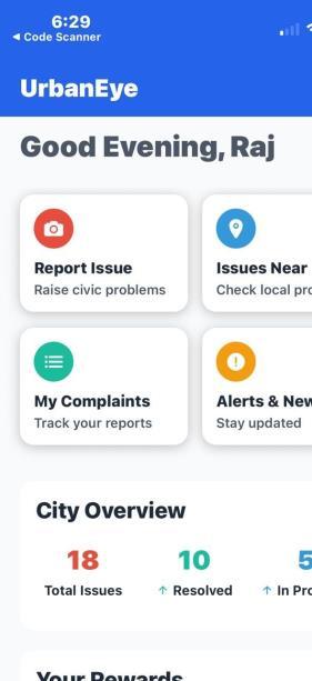
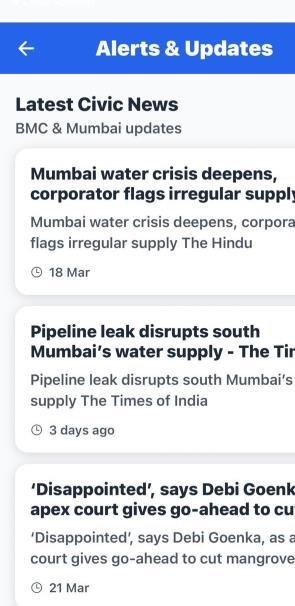
5: HomeScreenandAlerts&UpdatesPageofUrbanEyeApplication
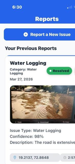
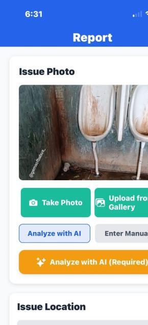
Userscanreportissuesbyuploadingimages,selectingcategories,andprovidinglocationdetails.Thisprocessissimpleand efficient,ensuringquicksubmissionof complaints.Thefollowingfigureillustratestheissuereportinginterfaceofthesystem.
International Research Journal of Engineering and Technology (IRJET) e-ISSN: 2395-0056
Volume: 13 Issue: 03 | Mar 2026 www.irjet.net p-ISSN: 2395-0072
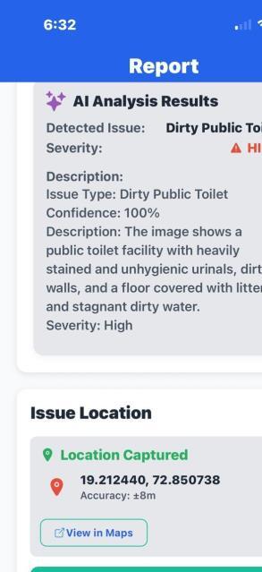
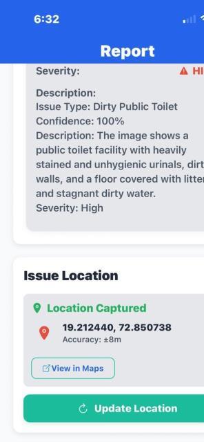
Thedataisthenprocessedandstoredinthebackend,andthereportedissuesaredisplayedonthemapinrealtime.This allowsusersandadministratorstovisualizeproblemsgeographically.Thefollowingfigureshowsthemapvisualizationof reportedissues.
The system also includes a voucher-based reward mechanismto encourage active user participation. Users are provided withrewardpointsorvouchersforreportingvalidandusefulissues.Thisfeaturemotivatescitizenstocontributetowards maintainingurbaninfrastructureandincreasesengagementwiththeplatform.Thevouchersystemis integratedwiththe backend, where rewards are generated based on the authenticity and impact of the reported issue. Users can view and managetheirearnedrewardswithintheapplication,makingthesystemmoreinteractiveanduser-centric.
© 2026, IRJET | Impact Factor value: 8.315 | ISO 9001:2008 Certified Journal | Page1862
International Research Journal of Engineering and Technology (IRJET) e-ISSN: 2395-0056
Volume: 13 Issue: 03 | Mar 2026 www.irjet.net p-ISSN: 2395-0072

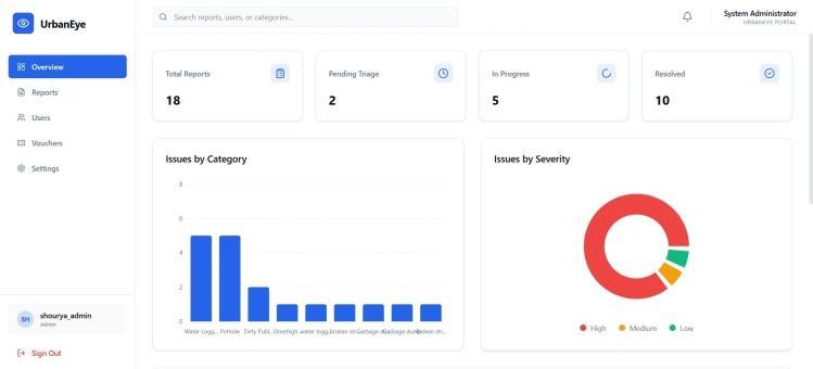
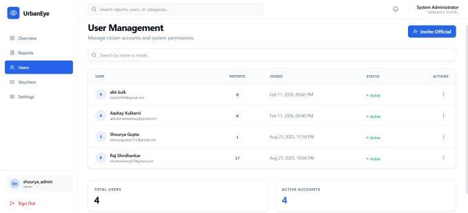
TheresultsofthesystemdemonstratethatUrbanEyeefficientlyenablesuserstoreportandtrackcivicissues.Thereal-time mapvisualizationhelpsinidentifyingproblem areasquickly,whiletheadmindashboardallowsauthoritiestomonitorand manageissueseffectively.Thefollowingfigurerepresentstheadmindashboardandmonitoringsystem.
International Research Journal of Engineering and Technology (IRJET) e-ISSN: 2395-0056
Volume: 13 Issue: 03 | Mar 2026 www.irjet.net p-ISSN: 2395-0072
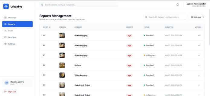
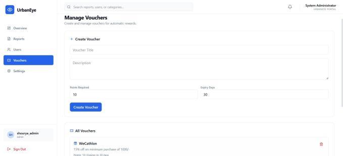
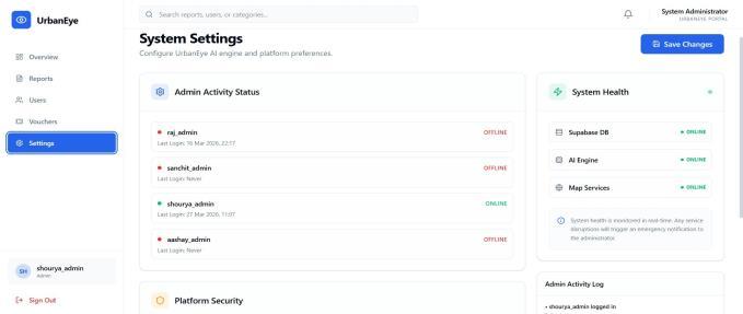
8: AdminDashboardandMonitoringSystem
Thesystemwastestedunderdifferentscenarios,anditshowed reliableperformanceintermsofdatahandling,response time,andusability.Featuressuchasnotifications, news updates, and reward mechanisms enhance user engagement and participation. The integration of cloud services ensures scalability, while the modular design allows easy future enhancementssuchasAI-basedissuedetectionandgovernmentintegration.
Theproposedsystemcanbefurtherenhancedbyintegratingadvancedtechnologiesandexpandingitsfunctionality.Artificial intelligencecanbeimplementedmoreeffectivelytoautomaticallydetectandclassifyurbanissuesfromimageswithhigher accuracy.[3] Integration with government and municipal systems can enable direct action on reported issues, improving response time and efficiency. The application can also be extended to support real-time alerts, predictive analysis of problem-proneareas,andmultilingualsupporttoincreaseaccessibilityforawiderrangeofusers.
Additionally,thesystemcan incorporate advanced GIS featuresforbettervisualizationandanalysisofurbandata.Asocial media integration feature can also be introduced, where reported issues are automatically posted on platforms such as Twitter,taggingtherespectivemunicipalauthorities.Thiswillincreasevisibility,ensureaccountability,andaccelerateissue resolutionthroughpublicengagement.[4]
Furthermore,scalabilitycanbeimprovedtosupportdeploymentacrossmultiplecities,makingit acomprehensivesmart city solution. Features such as IoT integration, automated issue detection using sensors, and enhanced reward mechanismscanfurtherincreaseuserengagementandsystemeffectiveness.
International Research Journal of Engineering and Technology (IRJET) e-ISSN: 2395-0056
Volume: 13 Issue: 03 | Mar 2026 www.irjet.net p-ISSN: 2395-0072
Inthispaper,anAI-poweredurbanissuemappingsystem,UrbanEye,ispresentedtoaddressthechallengesofinefficient civic issue reporting in urban areas. The system provides a user-friendly mobile platform that enables citizens to report issues such as potholes, waste accumulation, and infrastructure damage in real time. By integratingtechnologiessuchas React Native, Supabase, and map-based visualization, the system ensures efficient data collection, processing, and monitoring.
TheimplementationresultsdemonstratethatUrbanEye improvescommunicationbetweencitizensandauthoritieswhile enhancing transparency and accountability. Features such as real-time mapping, notifications, and reward mechanisms encourageactiveuserparticipationandcontributetofasterissueresolution.
Overall,theproposedsystemoffersascalableandeffectivesolutionforsmartcitymanagement.Withfutureenhancements such as AI-based automation, government integration, and social media connectivity, UrbanEye has the potential to significantly improve urban infrastructure management and support the development of smarter and more responsive cities.
[1]Walwadkar,Dnyanesh&Patil,Jayesh&Hussain,Mujahid&Yadav,Saurav.(2022).SmartCivicIssueReportingSystem. InternationalJournalofAdvancedResearchinScience,CommunicationandTechnology.10.48175/IJARSCT-2659.
[2]Prasad,S.K.,Patil,R.,Beldare,S.,&Shinde,P.A.(2016).CivicComplaintApplicationunderSmartCityProject.
[3]Naveen.V,Umesh.I,Raghavender.M,Vaishnavi.B,Devi.G,Dr.Venkataramana.B,2026,ATheoreticalFrameworkfor AI-AssistedCivicIssueReportingandValidationinSmartCities,INTERNATIONALJOURNALOFENGINEERINGRESEARCH &TECHNOLOGY(IJERT)Volume15,Issue01,January–2026,10.17577/IJERTV15IS010731
[4]Rute Bastardo, João Pavão, Nelson Pacheco Rocha, Crowdsourcing Technologies to Promote Citizens’ Participation in SmartCities,aScopingReview,ProcediaComputerScience,Volume219,2023.
[5] Kamble, Mr & Shinde, Mitesh & Teli, Shubhangi & Dalal, Preyash & Karpe, Samruddhi. (2024). CitizenConnect: RealTimeGrievanceManagementApp.IARJSET.11.10.17148/IARJSET.2024.11213.
[6]K.C.Kevinchacko,E.Dinesh,R.Balamurugan,andT.Abishek,“CitizenDrivenCivicIssuePlatform,”2024.
[7]T.Bhandare,S.Shukla,R.Bava,andI.Ahirrao,
“Civic Complaint Registration Application for Citizens of Urban/Rural Areas,” Journal of Emerging Technologies and InnovativeResearch(JETIR),vol.11,no.5,pp.b783–b790,May2024.
[8]“Crowdsourced Civic Issue Reporting and Resolution System,” International Journal of Research Publication and Reviews(IJRPR),vol.6,issue11,2025.
[9]“SmartCivicIssueManagementSystem,”2024.