
International Research Journal of Engineering and Technology (IRJET) e-ISSN:2395-0056
Volume:12Issue:04|Apr2025 www.irjet.net p-ISSN:2395-0072
International Research Journal of Engineering and Technology (IRJET) e-ISSN:2395-0056
Volume:12Issue:04|Apr2025 www.irjet.net p-ISSN:2395-0072
Mr. Salim Khan1 , Shubham Muthal2 , Sneha Palde3 , Priti Rumane4 , Gauri Walve5
*1 Assistant Professor, Department of Information Technology, Matoshri College of Engineering & Research Centre, Eklahare, Maharashtra, India
*2,3,4,5 Students, Department of Information Technology, Matoshri College of Engineering & Research Centre, Eklahare, Maharashtra, India ***
Abstract - Effective river flood forecasting is essential for minimizing the impacts of floods on communities, infrastructure, and ecosystems. Accurate predictions help mitigate immediate flood effects and play a key role in longterm disaster risk reduction and preparedness. The process integrates hydrological andhydraulic models, whichestimate river flow based on rainfall, watershed characteristics, and other factors. Hydraulic models simulate water movement through river channels and floodplains, offering insights into flood spread.
Flood inundation is determined by calculating water levels and mapping areas at risk. Technologies like Geographic InformationSystems(GIS),remotesensing,andreal-timeflood monitoring systems have significantly improved forecasting accuracy. GIS enables spatial analysis of flood-prone areas, while remote sensing, including satellite data, provides realtime information on land cover, river flow, and rainfall. Realtime monitoring systems, such as sensors and gauges, provide up-to-date data on water levels, enhancing emergency response.
Despite advancements, challenges remain. Uncertaintiesarise from variable weather patterns, limited data, and the complexity of flood dynamics. Urbanization also impacts natural drainage systems, exacerbating flood risks. Data quality and spatial resolution further complicate consistent forecasting.
Ongoing advancements in machine learning, algorithm development, and data integration are improving the precision and timeliness of predictions. Collaboration among meteorological andhydrological agencies andaccesstoopensource data contribute to more reliable forecasting.Enhanced flood forecasting aids both immediate disaster response and long-term infrastructure planning, ensuring betterprotection for communities and ecosystems.
Key Words: Floodforecasting,Hydrologicalmodels,Hydraulic models, GIS, Remote sensing,Floodrisk,Disastermanagement, Flood prediction, Real-time monitoring.
Riverfloodingisoneofthemostwidespreadanddestructive natural disasters, impacting communities, infrastructure,
agriculture, and ecosystems across the globe. The consequencesofsucheventsunderscorethecriticalneedfor effectivefloodmanagementstrategies.Accurateandtimely floodforecastingisessentialinminimizingthedevastating effectsoffloodingbypredictingnotonlythemagnitudeof river flow but also the extent to which floodwaters will inundate surrounding areas. With the ongoing challenges posed by climate change and the increasing frequency of extremeweatherevents,thedemandforpreciseandreliable floodpredictionshasneverbeenmoreurgent.
Inundation forecasting, or predicting the reach of floodwaters,isacomplextaskthatinvolvesunderstanding the interactions between rainfall, river dynamics, topography, and human infrastructure. These complex factors require an integrated approach to accurately estimate flood risks and their potential consequences. As flooding events become more unpredictable, developing advanced forecasting tools has become essential in enhancingdisasterpreparednessandreducingflood-related damages.
To achieve reliable flood predictions, a multidisciplinary approach is employed. Hydrological models simulate the movementof waterthrough a catchmentarea,takinginto account inputs such as rainfall, snowmelt, and land characteristics. Hydraulic models, on the other hand, simulatetheriver'sbehavioroncewaterentersthechannel, includingoverflowandfloodplaindynamics.Real-timedata from river gauges, weather stations, and remote sensing technologiesfurtherrefinethesepredictions,ensuringthat authorities have accurate and up-to-date information to informtheirdecision-making.
These predictions are often visualized through flood inundationmaps,whichrepresentareasthatareatriskof flooding under various flow conditions. Tools like GeographicInformationSystems(GIS)andremotesensing technologiesallowforthevisualizationandanalysisofflood risks over large areas, assisting authorities in planning evacuation routes, protecting critical infrastructure, and allocatingresourceseffectively.Theintegrationofreal-time monitoringsystemsenhancestheabilitytoadjustforecasts quickly and improves emergency response efforts during floodevents.
International Research Journal of Engineering and Technology (IRJET) e-ISSN:2395-0056
Volume:12Issue:04|Apr2025 www.irjet.net p-ISSN:2395-0072
As technology advances, flood forecasting systems are becomingmoreaccurateandefficient,withtheintegrationof machine learning and data analytics. These innovations enable better disaster response, ensuring that affected communities are better prepared to mitigate the social, economic,andenvironmentalimpactsofriverflooding.
1.HydrologicalandHydraulicModeling
Hydrologicalmodelspredictthemovementofwaterwithina watershed,consideringfactorssuchasrainfall,runoff,and the characteristics of the land surface. These models are crucialforunderstandinghowrainfallisconvertedtorunoff andhowthatrunoffisroutedthroughriversystems.Early hydrological models, such as the unit hydrograph model (Sherman,1932),laidthefoundationforfloodforecastingby offeringsimplifiedrepresentationsofwatershedresponseto rainfall. Over time, more sophisticated models have been developed,suchasconceptual rainfall-runoffmodels(e.g., theHBVmodel byBergström,1976)andphysically-based models (e.g., the SWAT model developed by Arnold et al., 1998), which simulate the complex interactions of hydrologicalprocessesinariverbasin.
2.FloodInundationMappingandGISIntegration
Flood inundation mapping, which represents the areas affected by floodwaters under various flow scenarios, has been a major area of research in flood forecasting. Traditional floodplain mapping often used simplistic approaches such as static floodplain delineation based on historicalfloodeventsorextremeflowconditions.However, recent advancements have integrated Geographic Information Systems (GIS) with flood modeling to create dynamic,real-timeinundationmaps.Forexample,Koksetal. (2015)reviewedhowGIShasimprovedfloodriskmapping byallowingformoredetailed,interactivevisualizationsand analysis of flood impacts on land use, infrastructure, and population.
GIS-basedfloodmodeling(e.g.,FLO-2D,MIKEFLOOD)has beenakeyadvancementinthisarea,enablingfloodexperts to simulate and map the spatial extent of flooding with higher resolution and greater accuracy. These models integrate terrain data (digital elevation models), land use data,andhydraulicmodelingoutputstopredicthowwater flows over a landscape, adjusting for factors such as urbanization and infrastructure like dams and levees. Pappenbergeretal.(2007)andWinsemiusetal.(2013)have demonstratedtheimportanceofincludingspatiallyexplicit data in flood inundation models to improve accuracy and ensureamorerealisticrepresentationoffloodrisks.
3.RemoteSensingandSatelliteTechnologies
Remotesensingtechnologies,particularlysatelliteimagery and aerial photography, have played a significant role in monitoring flood events in real-time. Synthetic Aperture
Radar (SAR), in particular, has been used to map flooded areas,evenundercloudcover,makingitapowerfultoolfor floodmonitoringinregionswhererainfallandcloudcover obscure optical images. The European Space Agency's CopernicusprogramhasprovidedfreeaccesstoSARdata, facilitating global flood monitoring efforts (Schaner et al., 2020).
4.EnsembleandUncertaintyModeling
Agrowingbodyofresearch hasfocusedonimprovingthe accuracy of flood predictions by addressing the inherent uncertaintiesinforecastingmodels.Ensembleforecastingis one approach that has gained traction in flood prediction, particularly in the context of weather and hydrological model uncertainties. Ensemble models use multiple simulations with varying initial conditions, model parameters,andboundaryconditionstogeneratearangeof possible outcomes, rather than a single deterministic forecast.
Advancementsinreal-timefloodforecastingsystemshave been pivotal in improving the timeliness and accuracy of floodpredictions.Thesesystemstypicallyrelyoncontinuous data from river gauges, weather stations, and satellite imagery to update flood predictions in real-time. For example, the National Weather Service's River Forecast Centers(RFC)intheUnitedStatesutilizereal-timedatato update river stage and flow forecasts every few hours. Similarly,UKFloodAlerts(EnvironmentAgency)userealtimedatafromrivergaugesandweatherforecaststoissue floodwarningsintheUK.
6.ChallengesandLimitations
Despite significant progress in flood forecasting, several challenges remain. The uncertainty of weather forecasts, particularlywithextremerainfallevents,continuestobea major source of error in flood predictions. Cheng et al. (2018) discussed how the variability in rainfall intensity, duration, and spatial distribution can cause significant discrepanciesinfloodpredictions,evenwithstate-of-the-art hydrologicalmodels.
Additionally,thecomplexityoffloodplaininteractions,such as the impact of urbanization and land use changes, adds anotherlayerofuncertainty.Floodmodelingmustaccount for factors like urban drainage systems, levees, dams, and floodplaindevelopments,whichmayalterthenaturalflowof riversandthespatialdistributionoffloodwaters.
1. Data Collection and Input Requirements
Theinitialstepinfloodforecastingistogatheressentialdata from multiple sources. This data forms the foundation for hydrologicalandhydraulicmodelsthatareusedtopredict
International Research Journal of Engineering and Technology (IRJET) e-ISSN:2395-0056
Volume:12Issue:04|Apr2025 www.irjet.net p-ISSN:2395-0072
riverflowandtheextentoffloodinundation.Keysourcesof datainclude:
Meteorological Data: Information such as precipitation and temperature is crucial for understanding rainfall-runoff processes and predicting river system flow. These data are generally acquired from weather stations or regionalmeteorologicalagencies.
HydrologicalData: Riverstagedata,representing thewaterlevelatspecificriverpoints,isgathered from gauges along the river network. This data is essential for understanding current river conditions.
Topographic and Geospatial Data: Highresolutiondigitalelevationmodels(DEMs)areused tomaptheriverbasin,floodplain,andsurrounding topography. This data supports hydraulic simulationsandfloodinundationmapping.
2. Hydrological Modeling
Hydrologicalmodelingisusedtosimulatewatermovement withinacatchmentarea(watershed)andestimateriverflow basedoninputssuchasrainfallandotherwatersources.The primaryobjectiveofthisprocessistoestimatestreamflowat keylocations,whichwill thenserveasinputforhydraulic modelstopredictpotentialflooding.
Rainfall-RunoffSimulation: Themodelsimulates how rainfall (or snowmelt) converts into runoff, whichultimatelyfeedsinto theriversystem. This processisinfluencedbysoilproperties,landcover, andterrainslope.Awidelyusedhydrologicalmodel for such simulations is the Soil and Water Assessment Tool (SWAT) (Arnold et al., 1998), whichintegratesphysical,hydrological,andclimatic data.
3. Hydraulic Modeling
Afterobtainingflowestimatesfromthehydrologicalmodel, hydraulicmodelingsimulatesthebehaviorofwaterwithin theriverchannel andfloodplain.Theaimistopredictthe water level (stage) at different locations and identify potentialfloodzones.
Flow Routing: Hydraulic models like HEC-RAS (Brunner, 2016) use flow data from the hydrological model to simulate water movement through the river system. These models take into account river geometry (e.g., width, depth, and slope) and resistances caused by natural features (e.g., vegetation) and man-made structures (e.g., dams,levees).
FloodplainMapping: Themodelcalculateswater levels at various locations, determining when the river’scapacityisexceeded,causingoverflow.These results are used to create flood inundation maps that illustrate the potential extent and depth of floodinginthesurroundingarea.
4. Flood Inundation Mapping Flood inundation maps are the primary output from
hydraulicmodels,showingareasatriskofflooding.These mapsarecriticalforriskassessment,emergencyplanning, and land-use strategies. The flood inundation mapping processincludes:
Flood Extent and Depth Calculation: Based on simulated water levels, the model calculates the extent and depth of flooding at various locations. Thisdataisessentialforevaluatinginfrastructure damage and identifying regions at risk of severe flooding.
GIS Integration: Theflooddataisintegratedinto Geographic Information Systems (GIS) to create comprehensivefloodhazardmaps.GIStoolsallow authorities to overlay flood data with socioeconomicand demographic information, enabling targetedresponsestovulnerablepopulationsand high-riskareas(Koksetal.,2015).
5. Real-Time Data Integration and Forecast Updating
Toenhancetheaccuracyoffloodpredictions,real-timedata integrationisvital.Bycontinuouslyupdatingforecasts,these systems can refine predictions as new data becomes available.
RiverGaugeData: Real-timedatafromriverstage gauges is used to update hydraulic models, providing current water level information that helps monitor flood progression and adjust forecasts.
Weather Forecasting: Short-term weather predictions, including rainfall forecasts, are incorporatedintohydrologicalmodelstoanticipate changesinriverflowandpotentialflooding.These forecasts are typically sourced from national meteorological services or global weather predictionmodels.
6. Uncertainty and Sensitivity Analysis
Floodforecastingisinherentlyuncertainduetofactorslike unpredictable weather patterns and variations in model parameters.Sensitivityanduncertaintyanalysisarecrucial forevaluatingtherangeofpossiblefloodoutcomes.
Ensemble Forecasting: Multiple simulations are runusingvariedinputdata,modelparameters,or boundary conditions to generate a range of potentialfloodoutcomes.
Monte Carlo Simulations: Stochastic techniques such as Monte Carlo simulations are employed to assessuncertaintyinmodelinputsandpredictions, producingprobabilisticfloodforecaststhatassistin decision-making.
1.DataCollectionandIntegration
Thefirststepintheproposedfloodforecastingsystemisto gatherandintegratevitaldatafromavarietyofsources.This integrateddata will provide the necessaryinputsfor both hydrologicalandhydraulicmodelstoforecastriverflowand
International Research Journal of Engineering and Technology (IRJET) e-ISSN:2395-0056
Volume:12Issue:04|Apr2025 www.irjet.net p-ISSN:2395-0072
potential flooding. The key components of data collection include:
Meteorological Data: Weather data such as precipitation,temperature,andwindspeedwillbe sourcedfromregionalmeteorologicalstationsand weather forecasting models. These datasets are crucial for estimating rainfall patterns and their subsequenteffectonriverflow.
Hydrological Data: Data on river discharge and waterstagelevelsatvariouspointsalongtheriver systemwillbegatheredfromrivergaugesinstalled along the riverbanks. This information helps monitortheriver'scurrentconditionandcalibrates theforecastingmodels.
Topographic Data: High-resolution Digital Elevation Models (DEMs) and floodplain maps provide topographical data for hydraulic simulationsandtheestimationoffloodextent.
LandUseandSoilData: Landcoverdataandsoil characteristics,suchasvegetationandimpervious surfaces, influence runoff and flow behavior. This dataiscollectedthroughGISandremotesensing.
2.HydrologicalandHydraulicModeling
Once the necessary data is collected, the system employs bothhydrological andhydraulicmodelstosimulatewater movementandpredicttheextentofflooding.
Hydrological Modeling: Thesystemusesmodels such as HEC-HMS or SWAT to simulate the movement of water within the catchment area based on rainfall, soil properties, and land use. Thesemodelsestimatestreamflowatvariousriver basinlocations,whichservesasinputforhydraulic simulations.
Hydraulic Modeling: Using the streamflow data fromthehydrologicalmodel,hydraulicmodelslike HEC-RAS simulate how water moves through the river channel and floodplain. These models take into account factors such as river geometry and resistancefromvegetationorstructures,providing predictions on water levels and identifying floodproneareas.
FloodInundationMapping: Thehydraulicmodel’s output is used to create flood inundation maps, which show the predicted extent and depth of flooding.ThesemapsareintegratedwithGIS-based data on infrastructure, population density, and socio-economic factors to assess flood risks to communitiesandcriticalinfrastructure.
3.EnsembleForecastingandUncertaintyAnalysis
Addressingtheuncertaintyinherentinfloodforecastingis crucial, particularly regarding rainfall and river flow predictions.Theproposedsystemincorporatestechniques to handle uncertainty and improve flood forecasting accuracy.
Ensemble Forecasting: The system will run multiple simulations using different assumptions, suchasvariationsinrainfall,temperature,andriver
conditions. This approach generates a range of possible flood scenarios, helping provide probabilisticpredictionsratherthandeterministic ones.Byusinganensembleofmodelsorscenarios, thesystemcanaccountformultipleoutcomesand offer authorities a better understanding of flood risks.
MonteCarloSimulations: MonteCarlosimulations will be employed to assess uncertainties in the model’s predictions. By running simulations with randomized variations in key parameters (e.g., rainfall intensity, river stage, and model calibration), the system will produce a range of floodscenariosandprovideuserswithaprobability distributionofpotentialfloodevents.
4.Real-TimeDataIntegrationandMonitoring
Real-timemonitoringandcontinuousdata integration are fundamental for delivering accurate and up-to-date flood forecasts. The proposed system will integrate several key componentsforreal-timeupdates:
RiverGaugeData: Real-timedatafromriverstage gauges will feed into the system, tracking water levels and discharge rates. This allows for continuousmonitoringoftheriverandhelpsupdate floodforecastsbasedonthecurrentsituation.
Weather Forecast Data: Short-term weather forecasts, including rainfall and temperature predictions,willbeintegratedintothehydrological models to predict changes in river flow and flood extent. These forecasts are especially helpful in regionspronetoflashflooding.
Satellite and Remote Sensing: Satellite imagery and synthetic aperture radar (SAR) data will be used to monitor the ongoing flood event. Remote sensingdata isespeciallyvaluableinareaswhere ground-based measurements are limited or unavailable,providingacomprehensiveviewofthe flood'sprogression.
5.FloodRiskCommunicationandDecisionSupport
Effective flood risk communication and decision-making support are integral parts of the proposed system. The system will provide stakeholders with accessible flood predictionsandreal-timeupdates.Keyfeatureswillinclude:
Flood Forecasting Dashboard: A centralized dashboard will display real-time flood forecasts, includingfloodinundation maps,riverstagedata, andpredictionsforaffectedareas.Thisdashboard will be accessible to emergency responders, government agencies, and the public for timely decisions.
AlertsandEarlyWarnings: Automatedalertswill begeneratedbythesystemtonotifyauthoritiesand communitiesofimpendingfloodrisks.Thesealerts willbesentviaSMS,email,ormobileapplicationsto ensure that affected populations are promptly informed.
International Research Journal of Engineering and Technology (IRJET) e-ISSN:2395-0056
Volume:12Issue:04|Apr2025 www.irjet.net p-ISSN:2395-0072
Risk Assessment and Mitigation: In addition to predicting flooding, the system will provide flood risk assessments that consider socio-economic vulnerabilities,potentialinfrastructuredamage,and human impact. This information will be used to guide evacuation planning, emergency preparedness,andresourceallocation.
6. Model Calibration, Validation, and Continuous Improvement
Maintainingtheaccuracyofthefloodforecastingsystemis essential for reliable predictions. The system will include continuous calibration, validation, and improvement measures:
Model Calibration: Hydrological and hydraulic models will be calibrated using historical data to ensureaccuratesimulationsofriverflowandflood dynamics.Calibrationwillinvolveadjustingmodel parameters to match observed river conditions duringpreviousfloodevents.
ModelValidation: Aftercalibration,thesystemwill bevalidatedusingindependentdatasetstoensure thepredictionsarereliableandcanbegeneralized fordifferentfloodevents.
ContinuousImprovement: Thesystemwillfeature mechanisms for ongoing evaluation of its performance. This will involve incorporating feedback from real-world flood events and incorporating new scientific advancements. As additional data becomes available,modelswill be updated to reflect changes in conditions and enhanceforecastaccuracy.
1. ImprovedFloodPredictionAccuracy
By integrating real-time meteorological, hydrological, and hydraulic data, the system is expected to significantly enhance the accuracy of flood forecasts. With the use of advanced models like HEC-HMS, SWAT, and HEC-RAS, coupled with real-time river gauge data and weather forecasts,thesystemwillprovidemorereliablepredictions offloodevents,reducinguncertaintiesinfloodforecasting.
2. EnhancedDecision-MakingSupport
Thesystem'sfloodforecastingdashboardandreal-timedata integration will empower decision-makers, emergency responders, and government agencies with up-to-date information. This will enable more informed decisionmakingregardingevacuationplanning,resourceallocation, and disaster response, ultimately improving flood risk management and reducing the impact on vulnerable communities.
3. Real-TimeMonitoringandDynamicUpdates
Throughcontinuousintegrationofreal-timedatafromriver gauges,satelliteimagery,andweatherforecasts,thesystem will provide timely updates on changing flood conditions.
Thisreal-timemonitoringcapabilitywillallowauthoritiesto issuemoreaccuratefloodwarningsandmakeadjustments to flood predictions as the event unfolds, improving emergencyresponseeffectiveness.
4. ComprehensiveFloodInundationMapping
The system will generate detailed flood inundation maps thatindicatetheextentanddepthoffloodingacrossaffected areas. These maps will be integrated with GIS-based data, offeringacomprehensiveunderstandingoffloodrisk.Such maps will help prioritize interventions, safeguard critical infrastructure, and support long-term planning efforts in flood-proneregions.
5. Enhanced Public Communication and Risk Awareness
Automatedalertsand notificationsthrough SMS, email,or mobile apps will ensure that affected populations receive early warnings and can take necessary precautions in a timelymanner.Byofferingreal-timefloodforecastsandrisk assessments through an accessible dashboard, the system will also increase public awareness of flood risks and encourageproactivedisasterpreparedness.
6. Probabilistic Flood Forecasts and Uncertainty Quantification
TheincorporationofensembleforecastingandMonteCarlo simulations will provide probabilistic flood predictions, accounting for a range of possible outcomes rather than deterministic forecasts. This will help communities and authorities better understand the likelihood of different floodscenarios, enabling more effective planning and risk mitigationstrategies.
7. Model Calibration and Continuous System Improvement
Thesystemwillbecontinuouslyimprovedthroughongoing calibrationandvalidationusinghistoricaldataandfeedback fromreal-worldfloodevents.Byincorporatingnewscientific advancementsanddataastheybecomeavailable,thesystem will stay up-to-date and increasingly accurate in its predictions.Thiscontinuousimprovementwillensurethat thesystemremainsrelevantandeffectiveinaddressingthe evolvingchallengesoffloodriskmanagement.
8. ReducedLossesandDamage
Byprovidingaccurateandtimelyfloodforecasts,thesystem willhelpmitigatetheimpactsoffloodingoncommunities, infrastructure, and the environment. Improved flood prediction and early warnings will allow authorities to evacuateat-riskpopulations,protectcriticalinfrastructure, andimplementfloodmitigationmeasures,reducingoverall economiclossesandcasualties.
International Research Journal of Engineering and Technology (IRJET) e-ISSN:2395-0056
Volume:12Issue:04|Apr2025 www.irjet.net p-ISSN:2395-0072
9. BetterFloodRiskAssessmentforInfrastructureand LandUsePlanning
The flood risk assessments provided by the system will enable authorities and urban planners to identify floodprone areas and make more informed decisions about infrastructure development and land use. This will help guidepoliciesrelatedtobuildingcodes,flooddefenses,and disaster preparedness, ultimately contributing to more resilientcommunities.
1. IncreasedForecastingPrecision
Thesystemwillsignificantlyimprovetheaccuracyofflood predictions by integrating real-time meteorological, hydrological, and hydraulic data. This will reduce the uncertainty associated with traditional flood prediction methods,providingmorereliableandtimelyfloodforecasts.
2. TimelyandEffectiveEarlyWarnings
Withtheintegrationofreal-timeriverstagedata,weather forecasts,andremotesensing,thesystemwilloffertimely flood warnings. This will allow authorities to issue alerts withgreaterprecision,ensuringthatcommunitiesatriskare evacuated on time and that resources are allocated effectively.
3. DetailedFloodInundationMapping
Thesystemwillproducehigh-qualityfloodinundationmaps, showingtheextent,depth,anddurationofpotentialfloods. These maps will help in identifying the most vulnerable areas,guidingemergencyplanning,evacuationroutes,and flood mitigation efforts. Authorities will have a clearer understandingoffloodrisksandconsequences.
4. Comprehensive Risk Assessment and Decision Support
ByusingGIS-baseddata,thesystemwillprovideadetailed flood risk assessment, including socio-economic vulnerability and infrastructure impact. This will assist decision-makersinprioritizingareasforfloodriskreduction and disaster preparedness, leading to more informed and effectiveplanning.
5. ProbabilisticForecastsforRiskManagement
ThroughensembleforecastingandMonteCarlosimulations, thesystemwillgenerateprobabilisticfloodforecasts,giving authoritiesarangeofpossiblefloodscenariosratherthana single deterministic outcome. This will enhance flood risk management by providing multiple scenarios that better reflectthe inherent uncertaintiesof weather patterns and riverdynamics.
6. ImprovedPublicAwarenessandCommunication
The system will enhance public awareness by providing accessible flood risk information through a user-friendly interface, including real-time updates and notifications.
AutomatedalertsviaSMS,email,ormobileappswillensure thatvulnerablecommunitiesreceivetimelyfloodwarnings andcantakeappropriateprecautions.
7. ContinuousImprovementandAdaptability
The system will be continuously calibrated and validated using real-world flood data, ensuring that it evolves over timetoaddressemergingchallenges.Thisadaptabilitywill allow the system to remain effective in predicting and managing floods as climate change and urbanization increasefloodrisks.
8. ReductioninFloodDamageandLossofLife
Byimprovingtheaccuracyoffloodpredictionsandoffering better early warnings, the system will help reduce the numberofcasualtiesandeconomiclossesduetoflooding. Withadvancedforecasting,authoritiescanbetterprepare, evacuate,andprotectpeopleandinfrastructure,minimizing theoverallimpactoffloodevents.
9. EnhancedInfrastructureandLandUsePlanning
The system's flood risk assessments will support better infrastructure development and land-use planning. Policymakers will be equipped with valuableinsightsinto flood-prone areas, helping them implement strategies for floodresilienceandsustainableurbandevelopment.
1. WaterSpeedMonitor
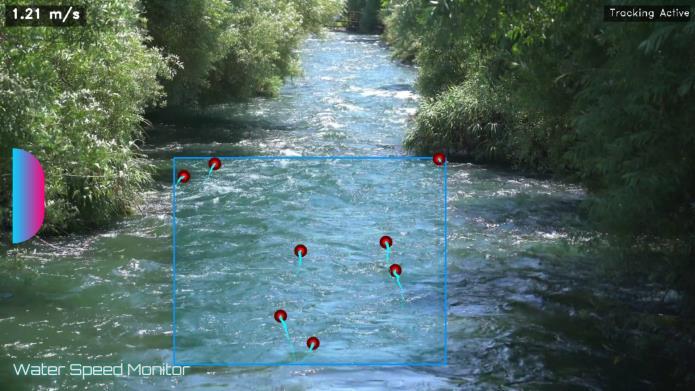
A WaterSpeedMonitor inriverfloodforecastingmeasures the velocity of river flow, helping predict the extent and timingofflooding.ItusessensorslikeacousticDoppleror electromagneticdevicestoprovidereal-timedata,whichis integrated into hydrological models for accurate flood predictions, aiding early warnings, risk mapping, and effectivefloodmanagement.
International Research Journal of Engineering and Technology (IRJET) e-ISSN:2395-0056
Volume:12Issue:04|Apr2025 www.irjet.net p-ISSN:2395-0072
4. Liquid Level Monitor
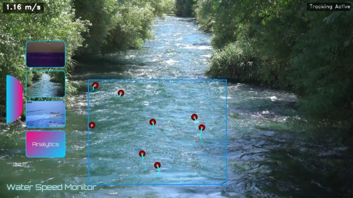
A WaterSpeedMonitor inriverfloodforecastingmeasures the velocity of river flow, helping predict the extent and timingofflooding.ItusessensorslikeacousticDoppleror electromagneticdevicestoprovidereal-timedata,whichis integrated into hydrological models for accurate flood predictions, aiding early warnings, risk mapping, and effectivefloodmanagement.
3. Water wave calculator
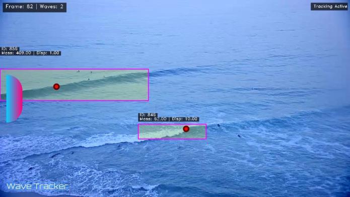
A Water Wave Calculator estimates key wave characteristics like wave height, wavelength, speed, and period.Itusesformulasbasedonfactorssuchaswaterdepth andwavefrequency.Thistoolisessentialforapplicationsin flood forecasting, coastal engineering, and navigation, helping predict wave movement and impacts in various waterenvironments.
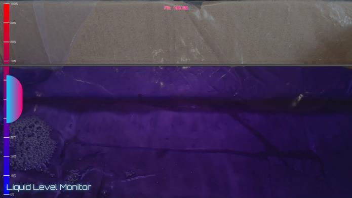
A Liquid Level Monitor is a device used to measure and trackthelevelofliquidinacontainer,tank,orreservoir.It helps ensure that liquid levels stay within desired ranges, preventing overflow or shortages. These monitors use sensors such as ultrasonic, capacitive, or float-based to providereal-timedata,usefulinindustrialprocesses,water management,andfloodmonitoringsystems.
The proposed flood forecasting system represents a significant advancement in managing and mitigating the impacts of river flooding. By integrating real-time data, hydrologicalandhydraulicmodels,andadvancedforecasting techniques, the system will provide accurate, timely, and actionablefloodpredictions.Thiswillenableauthoritiesto take proactive measures, reduce flood risks, and improve emergencyresponsestrategies.
The system's ability to generate detailed flood inundation maps,conductprobabilisticforecasts,andprovidereal-time updates will enhance decision-making, infrastructure planning,andpublicsafety.Additionally,theintegrationof ensembleforecastingandMonteCarlosimulationsensures that uncertainties are accounted for, offering a range of potentialfloodscenariosthatimproveriskmanagement. Ultimately, the system's continuous improvement and adaptabilitywillhelpaddresstheevolvingchallengesposed by climate change and urbanization, which are increasing flood risks globally. Through improved flood prediction, bettercommunication,andmoreinformeddecision-making, the system will play a crucial role in safeguarding communities, infrastructure, and ecosystems from the devastatingeffectsofflooding.
Byprovidingacomprehensivesolutionforfloodforecasting and risk management, the system will contribute to the resilience of flood-prone areas, helping reduce economic losses, prevent loss of life, and protect vulnerable populations.Itwillbeavaluabletoolintheglobaleffortto improvedisasterpreparednessandresponseinthefaceof increasinglyfrequentandseverefloodingevents.
International Research Journal of Engineering and Technology (IRJET) e-ISSN:2395-0056
Volume:12Issue:04|Apr2025 www.irjet.net p-ISSN:2395-0072
[1] Arnold, J. G., et al. (1998). "Soil and Water Assessment Tool (SWAT) User’s Manual." USDA-ARS Grassland,SoilandWaterResearchLaboratory.
[2] Brunner, G. W. (2016). "HEC-RAS River Analysis System:HydraulicModeling."USArmyCorpsofEngineers.
[3] Koks,E.E.,etal.(2015)."AGlobalMulti-HazardRisk MapforFlood,Earthquake,andTsunamiEvents."Science Advances.
[4] Mishra, V., & Coulibaly, P. (2009). "Developing a probabilisticfloodforecastingsystem:Ensembleapproach and uncertainty analysis." Hydrology and Earth System Sciences.
[5] Bates, P. D., & De Roo, A. P. J. (2000). "A Simple Raster-Based Model for Flood Inundation Simulation." JournalofHydrology.
[6] Cheng,L.,etal.(2012)."Developmentofreal-time floodforecastingsystems:AcasestudyinChina."Journal ofHydrology.
[7] Vieux, B. E. (2001). "Distributed Hydrologic ModelingUsingGIS."WaterResourcesResearch.
[8] Dixon, D., & J. P. (2015). "The Role of Remote Sensing in Flood Monitoring." International Journal of RemoteSensing.
[9] Madsen, H., et al. (2009). "Flood Forecasting with Hydrological Models: Calibration and Validation Issues." JournalofHydrology.
[10] Shrestha, S.,etal.(2017)."Ensemble-BasedFlood Forecasting for Decision Support." Hydrology and Earth SystemSciences.