
International Research Journal of Engineering and Technology (IRJET) e-ISSN: 2395-0056
Volume: 12 Issue: 05 | May 2025 www.irjet.net p-ISSN: 2395-0072
International Research Journal of Engineering and Technology (IRJET) e-ISSN: 2395-0056
Volume: 12 Issue: 05 | May 2025 www.irjet.net p-ISSN: 2395-0072
Dr. Shubhada koranne1 , D.A.Nagkirti2
1Assistant Professor & HOD of Civil Engineering Department GECA Chh.Sambhajinagar MH India
2MTech Student of Water Resources Engineering Department GECA Chh.Sambhajinagar MH India
Abstract - Groundwater is a crucial renewable natural resource that supports domestic, agricultural, and industrial needs, especially in semi-arid regions such as Chhatrapati SambhajinagartehsilinMaharashtra.Increasingpopulation, growing water demand, and erratic rainfall patterns have intensified the need for identifying viable groundwater zones to ensure sustainable resource management. This study employs Remote Sensing (RS) and Geographic Information System (GIS) techniques to delineate groundwater potential zones (GWPZ) across the tehsil. The methodology involved generating multiple thematic layers including geology, geomorphology, slope, soil type, drainage density, lineament density, and land use/land cover (LULC) from satellite imagery and existing datasets. These layers were assigned weights using the Analytical Hierarchy Process (AHP), reflecting each factor’s influence on groundwater recharge. A weighted overlay analysis in GIS was then performed to integrate the layers and assess groundwater potential across the region. The final output classified the area into five categories: very good, good, moderate, poor, and very poor potentialzones.Thefindings highlightthatRSandGISprovide a reliable, cost-effective, and comprehensive approach for evaluatinggroundwateravailabilityindata-scarceandwaterstressed regions. This spatial analysis serves as a scientific foundation for groundwater planning, helping decisionmakers implement appropriate conservation strategies, rechargestructures,andlanduseinterventions.Thestudyalso opens up opportunities for replicating the approach in other semi-arid landscapes facing similar hydrological challenges.
Key Words: Groundwater Potential Zones, Remote Sensing, GIS, Analytical Hierarchy Process, Weighted Overlay, Chhatrapati Sambhajinagar, Thematic Layers
1.INTRODUCTION
Groundwaterisakeywatersourcefordrinking,agriculture, andindustrythroughoutIndia.Itisparticularlyvitalinrural areas, where it supports irrigation and underpins food security.Around60%ofagriculturalirrigationand85%of householdwaterneedsinIndiaarefulfilledbygroundwater.
1.2
Despite its vital role, groundwater in India faces intense pressureduetoexcessivewithdrawal,lackofregulation,and
growing pollution. Falling water tables and unpredictable monsoon patterns further worsen the situation. This necessitatesadoptingscientificapproachesforsustainable groundwaterassessmentandmanagement.
SituatedinMaharashtra,ChhatrapatiSambhajinagartehsil lies in a semi-arid zone with limited surface water and irregularrainfall.Theareafrequentlyexperiencesdroughts and water shortages. Groundwater is the main source of water for both farming and domestic use, making its systematicassessmentandconservationessential.
Technologies like Remote Sensing (RS) and Geographic Information Systems (GIS) are effective in analyzing and mappingnaturalresourcessuchasgroundwater.Thesetools allowforthecreationandcombinationofthematiclayers likegeomorphology,soil,slope,anddrainage acrossvast regions. When integrated with models like the Analytical Hierarchy Process (AHP), they can accurately identify groundwater potential zones to support better water resourceplanning.
1. ToprocessLandsatOLIandSRTMsatellitedata.
2. ToderiveadrainagenetworkusingSRTMDEM.
3. To generate thematic maps for slope, elevation, drainagedensity,LULC,NDVI,geomorphology,and soil.
4. To identify suitable groundwater potential areas throughintegratedanalysisofallthematiclayers.
Chhatrapati Sambhajinagar tehsil is located centrally in Maharashtra, between latitudes 19.87° N and longitude 75.34°E,coveringanareaofapproximately1,292.65sq.km.
International Research Journal of Engineering and Technology (IRJET) e-ISSN: 2395-0056
Volume: 12 Issue: 05 | May 2025 www.irjet.net p-ISSN: 2395-0072
1.6.2
Thetehsilexperiencesasemi-aridclimatecharacterizedby hot summers and mild winters. Annual rainfall averages around710mm,withmostprecipitationoccurringduring themonsoonseasonfromJunetoSeptember.
Theregionpredominantlyfeaturesclayeyandloamysoils, which exhibit moderate to low water infiltration. The drainagesystemislargelydendritic,influencedbyseasonal rivers and streams that affect surface runoff and groundwaterrecharge.
1.6.4
The geological structure consists mainly of basaltic rocks from the Deccan Traps. These rocks, often fractured and weathered,significantlyinfluencethemovementandstorage ofgroundwaterinthearea.
2.1
The30-meterresolutionDigitalElevationModel(DEM)data was sourced from the Shuttle Radar Topography Mission (SRTM)viatheUSGSwebsite(http://edc.usgs.gov).Satellite imageryofthestudyarea,specificallyfromLANDSATOLI, wasalsoobtainedfromthesamesite.
The 30 m SRTM DEM data from USGS was processedforfurtheranalysis.
LANDSAT OLI imagery was utilized to develop a LandUse/LandCover(LULC)map.
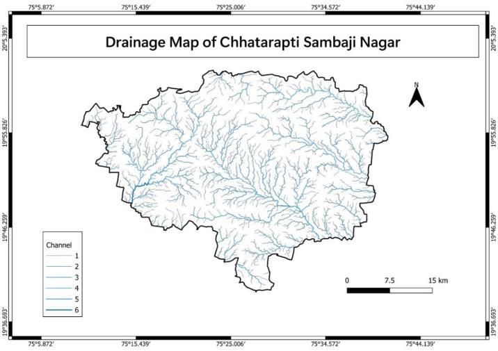
ThedrainagenetworkwasderivedfromtheDEM.
Adrainagedensitymapwasgenerated.
Geomorphological and lineament maps were createdforthestudyarea.
Parameters such as slope, drainage density, lineamentdensity,LULC,andgeomorphologywere integrated using weighted overlay analysis in ArcGIS.
The LANDSAT OLI dataset includes 11 bands. Seven of these bands 1 through 7 cover spectral ranges such as Blue,Green,Red,NearInfrared(NIR),SWIR1,andSWIR2at a30mresolution.
Other bands include Band 1 (Coastal aerosol), Band 8 (Panchromatic at 15 m), and Bands 10 and 11 (Thermal Infrared1and2)whichareacquiredat100mresolutionbut resampledto30minthefinaldataproduct.
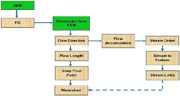
SRTM DEM and Landsat imagery were pre-processed to remove errors and normalize the data. The DEM was corrected for sinks using the Fill tool in ArcGIS’s Spatial Analystextension.Flowdirectionrasterswerethencreated to indicate the direction of water movement. A subset raster focusing on the area of interest was generatedfromtheDEM.Flowaccumulationwascomputed toidentifystreampaths,andathresholdof500pixelswas settodefinedrainagelines.Thesedrainagelineswerethen orderedusingStrahler’smethod.
Streamrasterswereconvertedintovectorlinefeaturesvia theStreamtoFeaturetool. Drainage basinswereoutlined usingtheBasintool,andpourpoints(wherewaterexitsthe basin) were used to finalize basin delineation. The raster basin map was then converted into a polygon feature for furtherspatialanalysis.
To form a complete drainage network, flow direction and accumulationrasterswereusedtotracewaterflowacross eachcellintheDEM.
QGISsoftwarewasemployedtomeettheobjectivesofthe project.
Saga Tool: Utilized for conducting drainage analysis.
Extract by Mask Tool:Usedtolimittheextracted datatothedefinedstudyarea.
Slopereferstothesteepestgradientorchangeinelevation over distance. Slope mapping is crucial to understand variations in terrain, detect geological disturbances, and identify features like fault scarps or tilted strata. It was created using the Surface Tool available under Spatial AnalystinQGISviathesequence:QGIS>Raster>Analysis> Slope.
TocreateadrainagemapinQGIS,theDEMwasfirstloaded andprocessedtofilldepressionsusingGRASSorSAGAtools. A flow direction raster was then generated to model how water moves across the terrain. Flow accumulation was calculatedtoidentifyareaswherewaterwouldcollect,and these were used to define stream channels based on a set threshold.
The resulting stream rasters were converted into vector layers,andstreamorderswereassignedusingsystemslike Strahler’s.Optionalwatershedboundariesweredefinedby settingpourpointsandusingwatershedtools.Thisprocess
International Research Journal of Engineering and
Volume: 12 Issue: 05 | May 2025 www.irjet.net
producedbothadrainagenetworkandwatershedmapsfor hydrologicalandwatershedmanagementpurposes.
3. INTERPRETATION AND INTEGRATION
InterpretationofremotelysenseddataintegratedwithGIS techniques provides an effective approach for assessing groundwater potential. In this study, six key thematic layers Rainfall,Slope,Geomorphology,DrainageDensity, LineamentDensity,andLandUse/LandCover(LULC) were analyzed based on their influence on groundwater occurrenceinthestudyarea.Theselayerswere examined andintegratedtodelineatepotentialgroundwaterzones.
3.1 Elevation
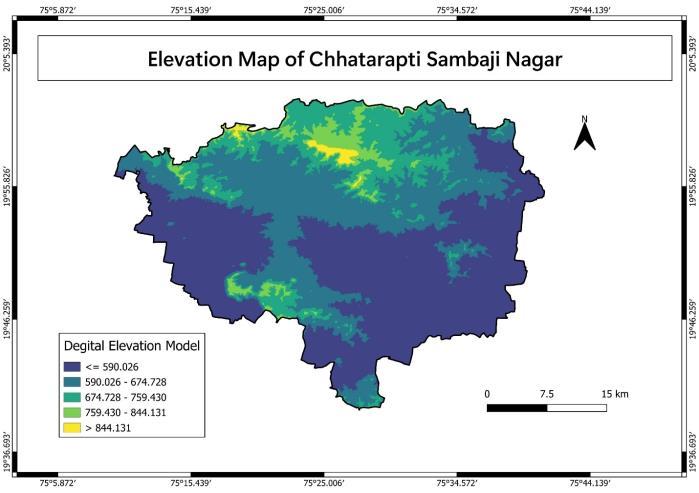
Areas below 590 meters exhibit very high groundwater potential due to flat terrain and enhanced infiltration, whereasregionsabove844metersshowpoorpotentialdue tosteepslopesandrunoff.
Table 1:Elevationandcategorywiseareadistribution
3.2 Slope
Nearlyflattoverygentleslopessupportbetterinfiltration and thus higher groundwater potential. Steeper slopes correspondtoreducedrecharge.
Table 2:Slopegradientandcategorywisearea distribution
International Research Journal of Engineering and Technology (IRJET)
Volume: 12 Issue: 05 | May 2025 www.irjet.net p-ISSN: 2395-0072
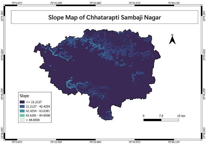
Fig 4 : SlopeMapofStudyarea
The slope map of the area depicts in general flat to very gentle slope in most part of the area. Steeper slope are encountered in the northern part of the area whereas moderateescarpmentslopehasbeenrepresentedineastern fringe of the area. Some moderate gentle slope has been notedinthecentralandeasternextremityofthestudyarea.
3.3 Geomorphology: -
Valley fills, pediplains, and shallow weathered pediplains emerged as highly favorable zones for groundwater accumulation,whilehillyterrainsandstructuralhillswere lesssuitable.
Table 3: GeomorphologyCategory
Class
1 PedimentPediplain
3
4
5 ModeratelyDissected
StructuralLowerPlateau
6 ModeratelyDissected
StructuralUpperPlateau poor
7 AbandonedQuarry Verypoor
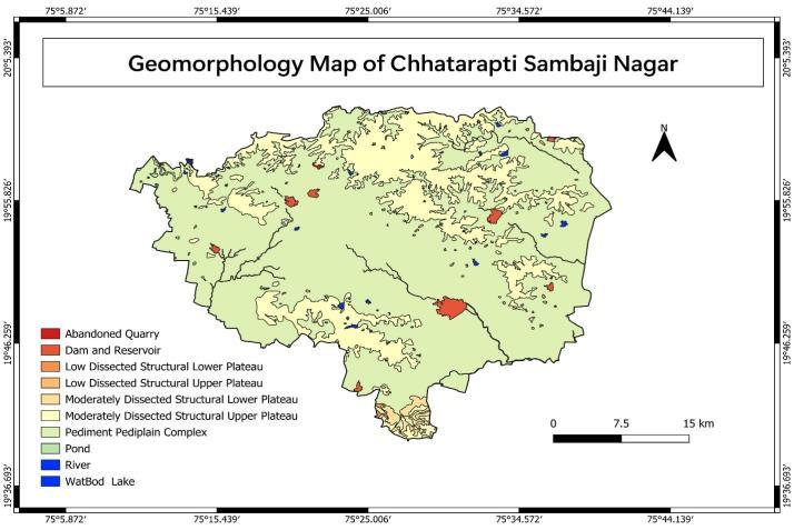
5: GeomorphologicalMapofStudyArea
Areas with low to moderate drainage density supported higher infiltration. High drainage density indicated higher runoffandthuslowerrechargepotential.
Table 4: DrainageDensityCategory
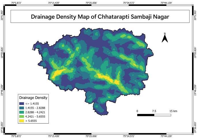
Fig.6 : DrainageDensityMapofStudyArea
3.5 NDVI
Normalized Difference Vegetation Index (NDVI) helps analyzevegetationcover.HighNDVIvaluescorrelatewith
dense vegetation and higher infiltration, while low NDVI implieslesscoverandlimitedrecharge.
Table 5: NDVIRangeTable
Sr.
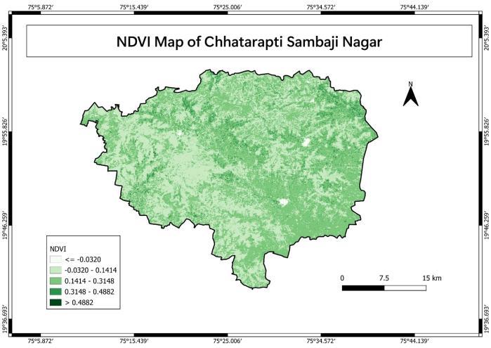
3.6 Land Use Land Cover
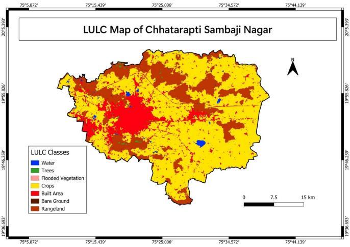
Agriculturalandforestedareasshowhighrechargepotential due to greater perviousness. Built-up and barren land impedepercolation,leadingtolowerpotential.
Table 6: LandUseCategory
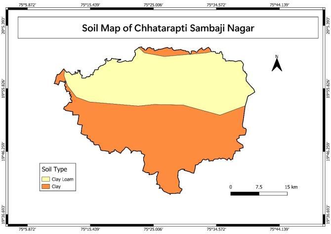
Soiltypessignificantlyinfluencerecharge.Loamyandsandy soils allow better infiltration, while clayey soils restrict watermovement,reducinggroundwateravailability.
Table 7: SoiltypeCategory
Thevariousfactorsinfluencingthegroundwaterpotentialof the area, as previously discussed, were assessed using knowledge-based weightages and rankings specific to the study region. These inputs were applied in a weighted averageoverlayanalysisusingrastertoolstodeterminethe groundwater potential zones. The parameters used in the
International Research Journal of Engineering and
Volume: 12 Issue: 05 | May 2025 www.irjet.net
analysis, along with their assigned
are presentedinTable–8
Table 8 : showingRankingandWeightageUsedfor GroundwaterPotentialZone
Parameter
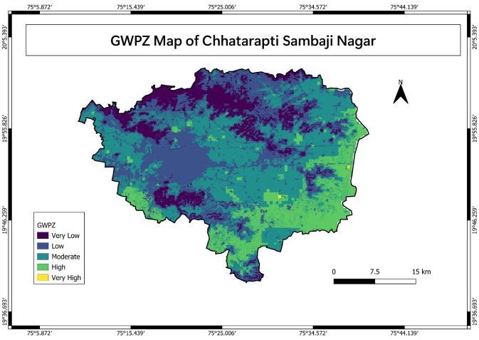
Table 9: GroundwaterpotentialzoneArea
GroundwaterpotentialzonesinChhatrapatiSambhajiNagar districtweredelineatedusingaweightedoverlayanalysisof variousthematiclayerssuchasElevation,Geomorphology, NDVI, Drainage Density, Slope, LULC, and Soil. Each layer wasassignedspecificweightsandranksbasedonitsimpact ongroundwaterrecharge.
Elevation,carryingthehighestweight(27%),revealedthat lower elevations (≤ 590 m) were more conducive to recharge, while higher elevations (> 844 m) were less favorable. Geomorphology (23%) indicated that fluvial featuresandwaterbodiesprovidedhighpotential,whereas denudational and man-made landscapes had limited rechargecapacity.NDVIvaluesalsoinfluencedpotential areas with dense vegetation (NDVI > 0.4882) promoted infiltration,whilebarrenzones(NDVI≤0.0320)wereleast favorable.
Areas with low drainage density (< 0.4598 km/km²) and gentle slopes (< 1.4°) supported recharge, unlike regions withhighdrainagedensityandsteepslopes(>12.3°),which hinderedit.LandUse/LandCoveranalysisratedforestsand water bodies as having good to very good potential, agriculturallandasmoderate,andbuilt-upandbarrenland as poor. Soil type played a role too clay loam allowed betterinfiltration,whereasclayeysoilswerelesspermeable.
International Research Journal of Engineering and Technology (IRJET) e-ISSN: 2395-0056
Basedontheseinputs,thedistrictwascategorizedintofive groundwater potential zones, ranging from Very Poor to VeryGood.Themajorityoftheareafallsundermoderateto poor zones, with only select low-lying regions exhibiting very good potential due to favorable conditions. This comprehensivemethodologyprovidesareliableframework forsustainablegroundwaterresourceplanning.
RemotesensingandGIStechniqueswerefoundto be efficient tools for identifying groundwater potential zones in Chhatrapati Sambhaji Nagar district.
Aweightedoverlayanalysiswasusedtointegrate multiple thematic layers including elevation, geomorphology, NDVI, drainage density, slope, LULC,andsoil.
Elevation and geomorphology emerged as key factors influencing the region’s groundwater rechargepotential.
A significant portion of the district is categorized undermoderatetopoorpotentialzones,suggesting ariskofgroundwatershortage.
High groundwater potential is mostly confined to low-lying areas where surface and subsurface conditionsarefavorable.
The findings highlight the importance of focused groundwater management initiatives, such as implementing artificial recharge systems and promotingwatersheddevelopment.
Thisapproachcanbereplicatedinothersemi-arid regions to support sustainable groundwater resourceplanning.
Future studies may incorporate field verification andwaterqualityanalysistoimprovethereliability ofgroundwaterpotentialmapping.
[1] CentralGroundwaterBoardReportongroundwater informationAhmednagar,Aurangabad,Jalana,Beed, Parbhani, Nanded, Nashik district, Maharashtra (2011)
[2] CentralGroundwaterBoardReportongroundwater information Adilabad, Nizamabad district, Telangana(2013)
[3] Dutta, D., Sharma and J. R., and Adiga, S. 2002. Watershed characterization, prioritization, development planning and monitoring remote sensingapproach,technicalreportISRONNRMS-TR103-2002Bangalore:ISRO
[4] Gottschalk,L.C.(1964).Reservoirsedimentation.In. V.T.Chow(ed), Handbook of Applied Geology. McGrawHillBookCompany,NewYork,Section7-1
[5] Horton, R.E. 1945. Erosional development of streamsandtheirdrainagedensity:hydrophysical approachtoquantitativegeomorphology.Geol.Soc. Amer.Bull.,No.56,pp.275-370
[6] Hare,P.H.andGardner,T.W.(1985):Geomorphic indicators of vertical neotectonism along convergingplatemargins,NicoyaPeninsula,Costa Rica. In: Morisawa M., Hack J.T. (Eds.), Tectonic Geomorphology,AllenandUnwin,Boston,pp.75–104
[7] Horton,R.E.,(1932),DrainageBasinCharacteristics, TransactionsofAmericalGeophysicalUnion,13,pp 350-361
[8] Melton, M.A. 1957. An analysis of the relations amongelementsofclimate,surfacepropertiesand geomorphology. Dept. Geol., Columbia University, TechnicalReport,11,Proj.NR389-042.off.OfNav. Res.,NewYork.
[9] Horton, R.E., (1945), Erosional development of streamsandtheir drainage basins:Hydrophysical approach to quantitative morphology, Geological SocietyofAmericaBulletin,56,275-370.
[10] Miller, V.C., (1953), A quantitative geomorphic studyofdrainagebasincharacteristicsintheClinch mountainarea,NewYork,DepartmentofGeology, ONR,ColumbiaUniversity,VirginiaandTennessee, Project,NR389-402,TechnicalReport3.
[11] Navin K.C. Twarakavi1 and Jagath J. Kaluarachchi 2006 Aquifer Vulnerability Assessment to Heavy MetalsUsingOrdinalLogisticRegression.
[12] Schumm, S.A., (1956), Evolution of Drainage Systems and Slopes in Badlands at Perth Amboy, NewJersey,GeologicalSocietyofAmericaBulleting, 67,pp597-646.
[13] Sharma, S.K., Singh, V. and Chandel, C.P.S. (2001) GroundwaterpollutionproblemandEvaluationof physico-chemicalpropertiesofGroundwater.Jour. EnvironmentalandEcology22(spl-2),319-324
[14] Strahler, A.N., (1957), Quantitative analysis of watershed geomorphology, Transaction of AmericanGeophysicalUnion,38,pp913-920.
[15] Strahler,A.N.,(1964),Quantitativegeomorphology ofdrainagebasinsandchannelnetworks,In:V.T. Chow (ed), Handbook of Applied Hydrology. McGrawHillBookCompany,NewYork,section,pp 4-11
[16] Tribhuvan, P.R. and Sonar, M.A., (June 2016), Morphometric Analysis of a Phulambri River Drainage Basin (Gp8 Watershed), Aurangabad District (Maharashtra) using Geographical Information System, Cloud Publications InternationalJournalofAdvancedRemoteSensing and GIS 2016, Volume 5, Issue 6, pp. 1813-1828, ArticleIDTech-593ISSN2320–0243.
Volume: 12 Issue: 05 | May 2025 www.irjet.net p-ISSN: 2395-0072 © 2025, IRJET | Impact Factor value: 8.315 | ISO 9001:2008 Certified Journal | Page747
International Research Journal of Engineering and Technology (IRJET) e-ISSN: 2395-0056
Volume: 12 Issue: 05 | May 2025 www.irjet.net p-ISSN: 2395-0072
[17] U.Förstner&G.T.W.Wittmann:MetalPollutionin theAquaticEnvironment.WithContributionsbyF. Prosi an J.H. van Lierde. With 102 figs., 94 ab., 486 pp. BerlinHeidelberg-New York: SpringerVerlag1979.ISBN-540(Berlin)0-387(NewYork)09307-9DM98.
[18] India Meteorological Department (IMD). (2021). Climate of India. Retrieved from https://mausam.imd.gov.in/
[19] Kothawale,D.R.,&RupaKumar,K.(2005).Onthe recentchangesinsurfacetemperaturetrendsover India.CurrentScience,88(9),1370–1377.
[20] Sikka, D. R. (1997). Mechanisms of south-west monsoonvariability.CurrentScience,73(8),682–689.
[21] GovernmentofMaharashtra.(2023).Districtprofile of Chhatrapati Sambhaji Nagar. Retrieved from https://aurangabad.gov.in/
[22] India Meteorological Department (IMD). (2021). Climate of Maharashtra. Retrieved from https://mausam.imd.gov.in/
[23] UNESCO.(2022).AjantaandElloraCaves.Retrieved fromhttps://whc.unesco.org/en/list/242/
[24] Valdiya, K. S. (2010). The making of India: Geodynamicevolution.Springer.