
International Research Journal of Engineering and Technology (IRJET) e-ISSN: 2395-0056
Volume: 12 Issue: 04 | Apr 2025 www.irjet.net p-ISSN: 2395-0072
International Research Journal of Engineering and Technology (IRJET) e-ISSN: 2395-0056
Volume: 12 Issue: 04 | Apr 2025 www.irjet.net p-ISSN: 2395-0072
Derick Samuel1 , K . Deepa2
1Department of Artificial Intelligence and Data Science, Loyola Institute of Technology, Chennai 600123, India. 2Department of Civil Engineering, Chennai Institute of Technology, Chennai ***
Abstract – Climatechangeisamajorfactorwhichimpacts on rainfall extremes and drought extremes all over the world. InthisresearchthestudyareaMubukuRiverbasin, facessuchextremityofrainfalleveryyearresultinginhuge volumeofsedimenttransportationtotheriver Thus,asan initialstep,therainfallrunoffquantityhasbeenthoroughly carriedoutaccordingthenatureofthetopography,soiland rainfall intensity. Techniques such as SCS method and geospatial tools are applied in determination of runoff quantityofthestudyarea.Fiveyearsofrainfall data from 2020to2024wasusedandrespectiverunoffquantityhas beencomputed. Thehighestrunoffcomputedof45568m3 for the year 2024 and the lowest runoff of 28672 m3 computedfortheyear2020.Itwasalsoobservedagradual increase of runoff throughout the five years in the study area.
Key Words: SCS method, Curve Number, Rainfall, Runoff, GIS, hydrologic soil
1. INTRODUCTION
The climate is a major determinant of water conditions throughitsinfluenceonthehydrologicalcycle(Vörösmarty etal.,2000). Changesinclimatepatternscanimpactwater systemsthroughshiftsintemperature,rainfall,andextreme weatherevents(IntergovernmentalPanelonClimateChange [IPCC],2021). Changesinclimatepatternslikeincreasesin global temperatures (Stocker et al., 2013), shifts in precipitation regimes (IPCC, 2021), and more frequent/severeextremeweatherevents(IPCC,2021)can directlyimpactsurfaceandgroundwatersystems.Altered rainfallandfloodingpatternsmodifywatershedhydrology andinfluencerunoffvolume/quality(Barnettetal.,2005). Rainfall-runoff is a mathematical model which directly relateswiththebasincharacteristicssuchasslope,soiltype, stream density and size of the basin (K Deepa, M Krishnaveni, 2012). Rainfall extremes result in flooding whichfurtherresultsinpollutionofsurfaceandsubsurface water contaminations, spreading of water borne diseases and transportation of sediments to surface water bodies, further resulting in reduction of storage capacity of the reservoir. On the other hand drought extremes result in reductioninsoilmoisturecondition,declineofwatertable andreductionofagricultureofacountry.Thus,itisessential tomonitoranyregionsorbasinorwatershedtheextremes ofthosehazards,inordertomanagetheenvironmentina
sustainable way. There by the economy of a region or countrycanbesaved.
Water resources management is a critical aspect of sustainable development, particularly in regions where agricultureanddomesticwatersupplyareheavilyrelianton rainfall (Govindaraju, et al, 2024) Assessing water availabilitybyevaluatingtherelationshipbetweenrainfall and runoff is therefore of paramount importance for effective watershed management, flood prediction and control of soil erosion. Rainfall-Runoff (RR) modelling is thereforeneededtopredicttheresponsesofawatershedto precipitation events. There are so many methods of modellingthatareusedinhydrologysuchasSCS-CN,SWAT, SHE,WaSIMandVICModelsamongothers (Yoshe,2025), (Solomon Eniyew, et al, 2024). In this study, the Soil ConservationService-CurveNumber(SCS-CN)methodhas beenemployedbecauseofitssimpleandrequiresminimum input data. The method is based on the concept of curve numbers (CN), which represent the runoff potential of a watershed based on Soil Type, Land Use and Land Cover (LULC),AntecedentMoistureConditions(AMC) (Chen,J., Hill, A. and Urbano, L. 2010). In the domain of flood management, this methodological approach significantly enhances forecasting, the establishment of early warning systems, and the design of flood control infrastructure. Additionally, it facilitates the identification of areas susceptible to flooding. Furthermore, the methodology contributestowaterharvestingandthemanagementofland use to promote sustainable agricultural practices. It is predominantlyemployedtoevaluatetheimpactsofclimatic variationsonwaterresources.Thismethodwasformulated bytheUnitedStatesDepartmentofAgriculture(USDA)and is recognized as one of the most extensively utilized techniques for estimating direct runoff resulting from precipitation(USDA,1972),(USDA,1985)andwasoriginally modelledforconditionsprevailingintheUS.Sincethen,it hasbeenadaptedtoconditionsinotherpartsoftheworld (Govindaraju, et al, 2024). Notwithstanding the advancements made by certain regional centers in developingsupplementarycriteria,thefundamentalconcept remains widely applied globally The method is well establishedbecauseofitsstabilityandabilitytoincorporate variousfactorscontributingtorunoff,includingbothspatial and non-spatial data sets such as daily and monthly
International Research Journal of Engineering and Technology (IRJET) e-ISSN: 2395-0056
Volume: 12 Issue: 04 | Apr 2025 www.irjet.net p-ISSN: 2395-0072
precipitation. Its ability to be integrated with GIS, RS and latelyAItoolsmakethemethodmorereliable.WeuseGIS, RS and AI because field measurements are laborious and time consuming. Spatial data has made it practical to accuratelycalculaterunoff(AyushiTrivedi,2021).However, advancementsingeospatialtechnologyhelptoincludethese variables for evaluating runoff from bigger watersheds. (Yoshe, 2025) Since conventional methods are time consumingandverydemanding,combiningGISandRSaids spatialanalysis(Deepa,Ketal,2017).Severalstudieshave obtained CN and runoff with RS and GIS. Researchers concludethattheseapproachesareflexible,popular,faster and reliable (Yoshe, 2025) (Abhijit M.Zende et al, 2014) notes that with increase in the availability of finer spatial resolutioninformationforGISandRSdataonvegetation,it’s possible to use the method for large areas with enhanced accuracy.Thekeyadvantagesofthismethodisitsseamless integration with GIS and RS techniques and this has revolutionized the accuracy and efficiency of the model (Shashi Poonam, 2022). Integration of GIS and RS in RR modelling have become indispensable in hydrological studiesduetotheirabilitytomanage,analysesandvisualize spatial data. GIS facilitates the extraction of critical watershed parameters such as slope, land cover, and soil type,whichareessentialforrunoffestimation.Inthecontext ofthismethod,GISenablesthespatialmappingofCNvalues, thus improving the precision of runoff estimations. RS providessatelliteimagery ofthe earth’s environment that helpstoestimaterunoffandpotentialfloods.GISisalsoused asanefficienttooltoprepareinputdataobtainedfromRS.It can offer data for inaccessible locations with huge spatial and temporal variability (Solomon Eniyew, et al, 2024), (Yoshe, 2025). Studies have shown that SCS method is particularly effective in the data scarce regions, making it suitableforapplicationsindevelopingnationslikeUganda. Ugandanmodelshavetargetedurbansettingsanddeveloped river watersheds, leaving a gap in rural watersheds. Elkassar, G. et al, posits that alterations in land use accompanying urban expansion lead to increased surface runoffandaconcomitantriseinfloodrisk.Ifinadequately managed,surfacerunoffmayinflictdamageonpropertyand infrastructurewhilealsocontributingtothesiltingofwater resources(Elkassar,G. etal2017) MubukuRiverbasinis locatedinSouth-westernUganda,ischaracterisedbyhigh rainfall intensity, steep slopes, and diverse land use practices.Insuchabasin,SCS-CNmethodcanbeparticularly useful given its complex topography and varying land use patterns.Thesefactorsmakeitpronetoissuessuchassoil erosion, flooding, and water resource degradation. This region has endured floods due to natural and human interventions.Stepstoreversethesechallengessuchastree plantingtoboostsoilandwatermanagementeffortsarenot successfulasanticipated.
ThestudywillfocusontheMubukuRiverbasininUganda, situatedwithintheRwenzoriMountainsregion.Thisbasin encompasses a defined geographical area, including its tributaries and associated water resources within its catchmentarea(Bua,B.;Ojirot,2014).Thespatialextent ofthestudywillbebasedonthecoordinatesoftheMubuku Riverbasin,whichgenerallyrangebetweenapproximately 0.311°N to 0.375°N latitude and 29.783°E to 29.953°E longitude.Thesecoordinatesoutlinetheboundariesofthe basin and include its tributaries and water resources as showninfigure1.
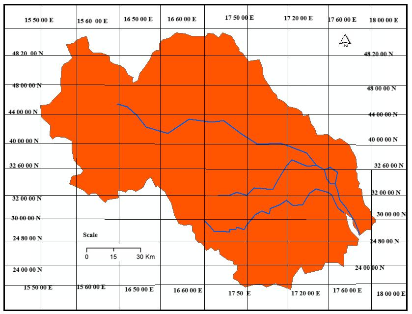
TheMubukuRiverbasininsouthwesternUgandaprovides essentialwaterresourcesthatlocalcommunitiesdependon (Elkassar,G. et al 2017).The basin supports livelihood activitiessuchasagriculture,livestockrearing,anddomestic waterusage(MWE,2018).TheMubukuriverbasinareais about 256 km2. The temperature data indicates average warmingof1.3°Cbetween1980-2020.Thestudyareahas threerainfallstationslocatedinaroundsuchasFortportal, Kasesee,andMubukurespectively.Theslopetopographyof thestudyarea isin theformofmildslopesdistributed all over the study area. The basin was divided into two subbasinsbasedontherivernetwork.
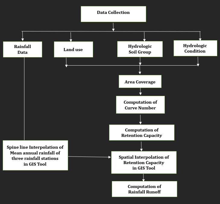
Themethodologyadoptedinthisresearchhasbeendepicted infigure2.Thestep-by-stepprocedurehasbeenexplained asbelow.
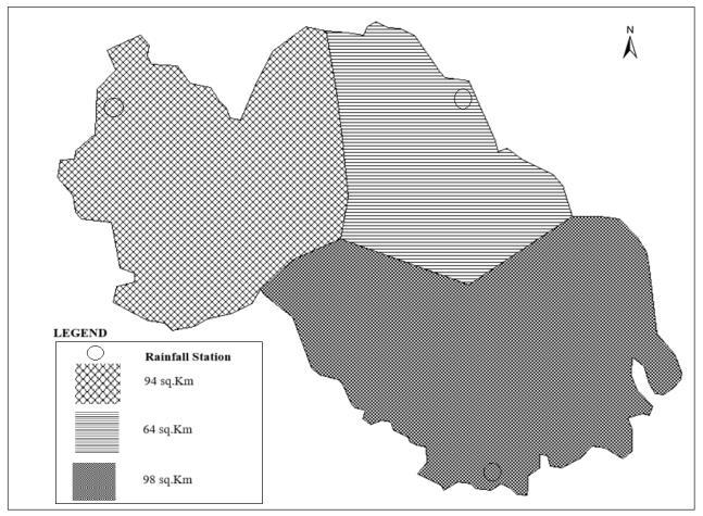
Step 1 – Thematic maps of landuse type, Landuse conservation practice, hydrologic soil group, hydrologic conditionwaspreparedinArcGISsoftware.Therainfalldata procuredfromthreeraingaugestationsunderwentspatial interpolationviathesplinemethod.Monthlyrainfallrecords spanning five years (2020-2024) were gathered from the Uganda Meteorological rainfall data center. The Thiessen
International Research Journal of Engineering and Technology (IRJET) e-ISSN: 2395-0056
Volume: 12 Issue: 04 | Apr 2025 www.irjet.net p-ISSN: 2395-0072
polygon method was employed to ascertain the average distribution of rainfall across the entire study area, as depicted in Figure 3. The satellite imagery utilized for the landuseandcovermapofthestudyareawassourcedfrom thewebsite:www.EarthExplorer.usgs.gov
Landsat8satelliteimagerywasacquiredinTIFFformatand subsequentlyreclassifiedutilizingsupervisedclassification methodologieswithintheArcGISenvironment.Fiveclasses oflandusepatternhavebeenclassifiednamely,builtupland, waterbodies,smallcropgrowingregion,pastureland,fallow row crop growing etc. The extracted land use map of the studyareahasbeenpresentedinfigure5.
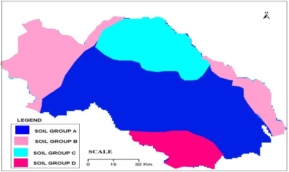
The spatial distribution of soil layers comprises 13% clay and87%sand,exhibitingeitherloamysandorsandyloam textures.Furthermore,thesaturatedhydraulicconductivity within the least transmissive layer, extending from the surface to 35 cm, ranges from approximately 32 micrometers per second to 38 micrometers per second. Figure 4illustratesthepresenceof hydrologicsoilgroups withinthestudyarea.
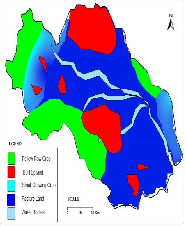
Landuse map was prepared based on the classification of landusetype,landtreatment,andhydrologicalconditionsin the study area catchment (Bhura CS etal, 2015) and (Wanielista, M.P. and Yousef, Y.A. 1993) . Finally, the
International Research Journal of Engineering and Technology (IRJET) e-ISSN: 2395-0056
Volume: 12 Issue: 04 | Apr 2025 www.irjet.net p-ISSN: 2395-0072
soil-covermapwasobtainedbysuperimposingtheland-use and the hydrologic soil group map which is presented in figure6.Superimposingwasachievedbyassigningweights for soil groups such as 3 for group A, 2 for group B, 1 for groupCandD.Also,forlanduseclass,theweightsassigned are 3 for fallow row crop and water bodies, 2 for small growing crop, 1 for pasture land and built-up land respectively.
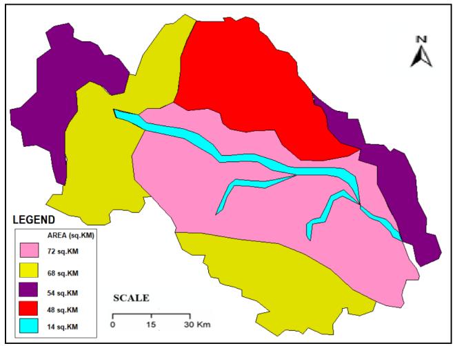
Figure 6. Super imposed area of Land use and soil cover map of the study area
Step 2 - The SCS runoff is articulated as the ratio of cumulative infiltration of rainwater (F) to the watershed storage(S),whichequatestotheratioofactualdirectrunoff to effective rainfall (total rainfall - initial abstraction) (K Subramanya, 1972) and (Pandey, A. and Sahu, A.K, 2009). The general equation for the Soil Conservation Servicemodelofcurvenumberiscomputedasfollows.
F = Q
S P–I (1)
ThedimensionsofF,S,QandIaresameandalsothevalueof initial loss (Ia) is considered as 0.2S. The quantity of infiltratedrainwaterafterrunoffbeginscanbeexpressedas:
F=(P-I)-Q ….(2)
Thus,
Q=(�� 0.2S)2 (P+0.8S) ….(3)
Soilmapsandlandusedatasetswereemployedtogenerate the Curve Number (CN). The value of S for specific watershed characteristics or land areas considered in the runoffcomputationisafunctionofthecurvenumber(CN). TherelationshipbetweenCNandSisdelineatedinequation 4.
CN= 2540
25.4+S ….(4)
Where,Sistheretentioncapacityofthesoil(cm).
TheCNvaluescorrespondingtoeachsoilhydrologicgroup, hydrologic condition, and associated land use classes are presented in Table 1. The weighted curve number for the areawasdeterminedusingequation(5),yieldingaWeighted CN value of 79.20. Consequently, the retention capacity S was calculated as 5.53 using equation (4). The results presentedinTable2indicateapersistentincreaseinrunoff depth within the study area. Runoff depth is directly proportionaltothehydrologicsoilconditionsandlanduse patterns (S. K. Mishra, 2000). The volume of runoff is computed with respect to superimposed area coverage of landusepatternandhydrologicsoilcondition.
Table -1: ComputationofCurveNumber
TheWeightedCurveNumber(CNw)
Table 2.ResultsofRunoffdepthforthestudyarea
International Research Journal of Engineering and Technology (IRJET) e-ISSN: 2395-0056
Volume: 12 Issue: 04 | Apr 2025 www.irjet.net p-ISSN: 2395-0072
Theresultsofrainfall-runoffprocessusingSCSmethodsays thatthestudyareaisinfluencedbyvariousfactors,suchas rainfalldistribution,abstraction,slope,andhydrologicalsoil types. TheapplicationofGIStoolplayedvitalinextractionof rainfalldistributionspatially, landuseclasscoveragearea andsoilgrouparea.Thecontinuousincreaseofrunoffdepth in the study area warns the water managers and decision makers to give more attention in water resources management in aspect of soil erosion, water conservation techniquesandlandmanagement.
[1] Abhijit M.Zende, Nagarajan R, Atal K.R., “Analysis of SurfacerunofffromYeralaRiverBasinusingSCS-CNand GIS”, International journal of Geomatics and Geosciences,Vol4,No3,2014.
[2] Ayushi Trivedi, MK Awasthi. “Runoff estimation by IntegrationofGISandSCS-CNmethodforKanariRiver watershed”. Indian Journal of Ecology 48 (6), 16351640, 20212021
[3] BarnettTP,AdamJC,LettenmaierDP.Potentialimpacts of a warming climate on water availability in snowdominated regions. Nature. 2005 Nov 17;438(7066):303-9.doi:10.1038/nature04141.PMID: 16292301.
[4] BhuraCSetal(2015),Estimationofsurfacerunofffor AhmedabadurbanareausingSCS–CNmethodandGIS, IJSTE.IntJSciTechnolEng1(11):2349–2784.
[5] Bua,B.;Ojirot,M.AssessingtheimportanceofriceasFoodan dIncomeSecurityCropinPuti-putiSub-country, Pallissa District,Uganda.Am.J.Exp.Agric.2014,4,532–540.
[6] Chen,J.,Hill,A.andUrbano,L.(2010)AGIS-BasedModel forUrbanFloodInundation.JournalofHydrology,373, 184-192.
[7] K Deepa, M Krishnaveni., “Suitable site selection of decentralised treatment plants using multicriteria approach in GIS”, Journal of Geographic Information System,Vol.4No.3(2012),ArticleID:19598,7pages.
[8] DeepakKumarTiwari,H.L.TiwariandRamanNateriya, 2021, Geomorphology-wavelet based approach to rainfall runoff modeling for data scarce semiarid regions,KolarRivercatchment,India,JournalofEngg. ResearchVol.10No.(1B)pp.29-40.
[9] Deepa, K.; Karthiga, A.; Rehana, K.; Rayen, V. Aquifer Mapping of Chennai city using GIS techniques. Imp. J. Interdiscip. Res. 2017, 3,165–172.
[10] Elkassar, G. Establishment of Water Distribution Scheduling and Operation Strategy for Sustainability ManagementofPilotIrrigationSchemeMubukuAreaUganda, “Application Case Study”. In Twentieth International Water Technology Conference IWTC20, Hurghada, Egypt, 18–20 May 2017; Negm, A.M., Ed.; Springer: Cham, Switzerland, 2019.R. Nicole, “Title of paperwithonlyfirstwordcapitalized,”J.NameStand. Abbrev.,inpress
[11] IPCC, 2021: Summary for Policymakers. In: Climate Change2021:ThePhysicalScienceBasis.Contribution ofWorkingGroupItotheSixthAssessmentReportof the Intergovernmental Panel on Climate Change [Masson-Delmotte,V.,P.Zhai,A.Pirani,S.L.Connors,C. Péan,S.Berger,N.Caud,Y.Chen,L.Goldfarb,M.I.Gomis, M. Huang, K. Leitzell, E. Lonnoy, J.B.R. Matthews, T.K. Maycock, T. Waterfield, O. Yelekçi, R. Yu, and B. Zhou (eds.)].CambridgeUniversityPress,Cambridge,United Kingdom and New York, NY, USA, pp. 3−32, doi:10.1017/9781009157896.001.
[12] K Subramanya, “Engineering Hydrology” Ministry of Agriculture, Govt. of India,” Handbook of Hydrology”, NewDelhi,1972.
[13] Gupta, Abhinav, Mohamed Hantush, and Rao Govindaraju. "Evaluating a conceptual hydrological model at gauged and ungauged basins using machine learning-basedlimits-of-acceptabilityandhydrological signatures."(2024).
[14] Glotov,V.E.,andL.P.Glotova."Waterrunoffvsmodern climatic warming in mountainous cryolithic zone in North-East Russia." IOP Conference Series: Earth and Environmental Science.Vol.107.No.1.IOPPublishing, 2018.
[15] Pandey, A. and Sahu, A.K. (2009) Generation of Curve Number Using Remote Sensing and Geographic InformationSystem.GeospatialWorld.
[16] S. K. Mishra, “A modified SCS-CN based hydrologic model”,NationalInstituteofHydrologyReport,TR(BR)2,2000.
[17] E Solomon, M Derege Tsegaye, Z Gebeyehu Abebe,, Combining geospatial information and SCS-CN for surfacerunoffestimationinRibwatershed,upperBlue NileBasin,Ethiopia“ ,Geomatics,NaturalHazardsand Risk15(1),1-23,2024.
[18] Shashi Poonam Indwar, Ankit Kumar, Rahul Jaiswal, R.V.GalkateandT.Thomas,“Rainfal-runoffmodellings usingSCS-CNandGISAprroachintheTawacatchment ofMadhyaPradesh,India,J.IndianWaterResour.Soc., Vol.42,No.3&4,Jul.&Oct.2022
International Research Journal of Engineering and Technology (IRJET) e-ISSN: 2395-0056
Volume: 12 Issue: 04 | Apr 2025 www.irjet.net p-ISSN: 2395-0072
[19] MatthewD.Stocker,YakovA.Pachepsky,RobertL.Hill, and Gonzalo Martinez, “Escherichia coli Export from ManuredFieldsDependsontheTimebetweentheStart of Rainfall and Runoff Initiation”, Journal of Environmental Quality TECHNICAL NOTES & PRELIMINARY COMMUNICATIONS, Published September6,2018
[20] Tassew,B.G.;Belete,M.A.;Miegel,K.ApplicationofHECHMSmodelforflowsimulationintheLakeTanabasin: The case of Gilgel Abay catchment, upper Blue Nile basin,Ethiopia.Hydrology2019,6,21.
[21] USDA (1972) Soil Conservation Service, National Engineering Handbook. Hydrology Section4. Chapters4-10.Washington,D.C:USDA.
[22] Vörösmarty,C.J.;Green,P.;Salisbury,J.;Lammers,R.B. Global water resources: Vulnerability from climate changeandpopulationgrowth. Science 2000, 289,284–288.
[23] www.EarthExplorer.usgs.gov
[24] Wanielista, M.P. and Yousef, Y.A. (1993) Stormwater Management.JohnWiley&Sons,Inc.,NewYork.
[25] AKYoshe,“Assessmentofanthropogenicandclimatedriven water storage variations over water-stressed river basins of Ethiopia”, Hydrology Research 55 (3), 351-379