
International Research Journal of Engineering and Technology (IRJET) e-ISSN:2395-0056
Volume: 12 Issue: 03 | Mar 2025 www.irjet.net p-ISSN:2395-0072
International Research Journal of Engineering and Technology (IRJET) e-ISSN:2395-0056
Volume: 12 Issue: 03 | Mar 2025 www.irjet.net p-ISSN:2395-0072
Pro.Sandhya Deshpande1 , Dr. Mukesh Shrimali2
1Research scholar (Computer Engineering) Pacific Academy Of Higher Education And Research, University Udaipur
2Department Of Computer Science Director, Pacific Polytechnic College, Pacific University India. ***
Abstract: This study presents a Land Use Land Cover (LULC) analysis for Junnar Taluka, Pune District, Maharashtra, using Remote Sensing (RS) and Geographic Information System (GIS). Satellite imagery from Landsat-8 was used to classify LULC categories, including agricultural land,forest,waterbodies,andbuilt-upareas.Thestudyaims to analyze the temporal changes inLULC patterns to assess land degradation and sustainable land management strategies. The results provide valuable insights for urban planning and agricultural development The dynamic transformationoflanduseandlandcoverhasemergedasa crucial aspect in the effective management of natural resources and the continual monitoring of environmental shifts. This study focused on the land use and land cover (LULC) changes within the Junnar Taluka in the Pune District, assessing the repercussions of land and water resource exploitation. Utilizing LANDSAT satellite images from 2009, 2014, and 2019, this research employed supervisedclassificationtechniquestoanalyzeandinterpret the data. The results provide valuable insights into the patterns and trends of LULC changes in the region, highlighting the impact of anthropogenic activities on the local environment. period from 2009 to 2019. Spatial and temporal dynamics of land use/cover changes (2009-2019) were quantified using three Satellite/Landsat images, a supervisedclassificationalgorithm.
Introduction:
1.1Thedynamictransformationoflanduseandlandcover has emerged as a crucial aspect in the effective management of natural resources and the continual monitoring of environmental shifts. This study focused on the land use and land cover (LULC) changes within the Junnar Taluka in the Pune District, assessing the repercussions of land and water resource exploitation. Utilizing LANDSAT satellite images from 2009, 2014, and 2019,alongwithVedasandBhavanopensourcedata,this research employed supervised classification techniques to analyzeandinterpretthedata.
Seven distinct LULC classes forest, irrigated cropland, agricultural land (fallow), barren land, shrubland, water, and urban land were delineated for classification purposes. The results provide valuable insights into the patterns and trends of LULC changes in the region, highlighting the impact of anthropogenic activities on the localenvironment.
ThetotalgeographicareaofJunnarTalukainPunedistrict, Maharashtra, is approximately 1,866 square kilometers, whichisequivalentto186,600hectares.
Total GeographicArea of Junnar Taluka:186,600 hectares andBuilt-upAreain2009:261.24hectareswhichis1.94%
1.2 LULC data based on expected trends in the region.
The data is structured for seven distinct LULC categories overselectedyears.
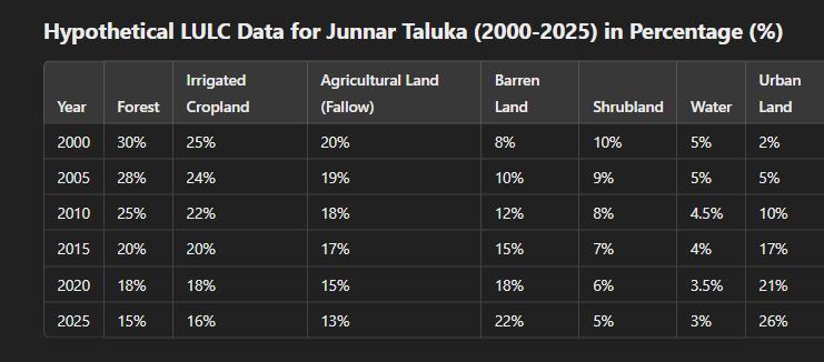
Tablenumber1:HypotheticalLULCDataforJunnarTaluka (2000-2025)inPercentage(%)
1.3 Observations & Trends
1. Forest Decline: Reduced from 30% in 2000 to 15% in 2025, mainly due to deforestation for urbanexpansionandagriculture.
International Research Journal of Engineering and Technology (IRJET) e-ISSN:2395-0056
Volume: 12 Issue: 03 | Mar 2025 www.irjet.net p-ISSN:2395-0072
2. UrbanGrowth:Increasedfrom2%in2000to26% in 2025, reflecting rapid urbanization and infrastructuredevelopment.
3. Barren Land Expansion: Increased from 8% to 22%, indicating soil degradation and land mismanagement.
4. AgriculturalLandDecline:Combinedirrigatedand fallowlanddecreased from 45%to29%,showing pressurefromurbanization.
5. Water Body Reduction: Shrunk from 5% to 3%, possibly due to climate change and land use changesaffectinghydrologicalresources.
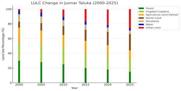
FigureNo.1:Thisis stackedbarchartillustratingthe changesindifferentLULCcategoriesinJunnarTalukafrom 2000to2025
The visualization highlights the decline in forest and agricultural land, the increase in barren land and urban expansion,andtherelativelystablewaterbodies.Thetotal study area of the junnar in Maharashtra encompasses 186,600 hectares built-up area in Junnar Taluka in 2009 would be approximately 1,866 hectares, and in 2019, it wouldbearound5,598hectares.LANDUSElandcover for 2010-11Forest Area is 1846.10sq. km. Net Area Sown is 9920sq.km.TheCultivableAreais 10576sq.km.forpune district.Percentage of Gross Irrigated Area to Gross Cultivated Area for junnar taluka in2001 to 2002 is 33.3 hector
The key findings underscored significant declines in barren land, agricultural land, and irrigated cropland, juxtaposed with an expansion in forest land, shrub land, andurbanland.
Junnar Taluka spans a total geographical area of 1,404.46 square kilometers, with 306.88 square kilometers classified as hilly terrain and 1,097.57 square kilometers identified as mappable areas suitable for agricultural or developmental activities. Notably, there are no salineaffectedregionswithinthejunnar taluka.Accordingtothe
2011 Census, Junnar has a population of 373,987 residents. The climate is characterized as a tropical monsoon, featuring distinct wet and dry seasons. Rainfall analysisindicatesanormalannualrainfallof760.9mm.In 2017, the region experienced significantly higher rainfall, totaling 1,133.5 mm. The decadal average annual rainfall from 2008 to 2017 was 887.49 mm, reflecting variations over the years. The study revealed substantial changes in JunnarTaluka'slandusepatternsovertheten-yearperiod from2009to2019.Spatialandtemporaldynamicsofland use/cover changes (2009-2019) were quantified using threeLANDSATsatelliteimages,asupervisedclassification algorithm, and the post-classification change detection techniqueinGIS.
IntroductionISRO'sopen-sourcesoftwareforlanduseand landcoverapplications:
Land use applications involve both baseline mapping and subsequentmonitoring.Whilelanduseandlandcoverare closely related, they are often used interchangeably. RemoteSensing(RS)andGeographicInformationSystems (GIS) have long been utilized for mapping and analyzing landuseandlandcover.Remotesensingdatahasenabled efficient and accurate studies of land use and land cover changesovertime[1][2].
Overtheyears,Landsatimageshave been instrumental in classifying and mapping various landscape components at a large scale [3]. The last three decades have seen extensive use of satellite images for these studies, which arethenprocessedandanalyzedusingGISsoftware.
ISRO'sopen-sourcesoftwaretools,suchasBhuvanandthe Indian Remote Sensing (IRS) data processing tools, provide valuable resources for land use and land cover mapping. These tools offer robust capabilities for analyzing satellite imagery and performing spatial data analysis, contributing to effective land use planning and modeling. Many researchers have highlighted the advantages of using GIS and remote sensing tools from ISRO for tackling land use issues and supporting land managementpractices.
ERDASImaginesoftwarehasbeensuccessfullyutilizedfor mapping land use and land cover changes through both unsupervisedandsupervisedclassificationmethodologies. Asadi et al. (2010) created a spatial digital database for Land Use/Land Cover using ERDAS image processing software, with subsequent analyses performed using Arc/InfoandArcViewGISsoftware.GISprovidesaflexible environment for collecting, storing, displaying, and analyzing digital data necessary for change detection [7]. Inrecentadvancements,theSemi-AutomaticClassification
International Research Journal of Engineering and Technology (IRJET) e-ISSN:2395-0056
Volume: 12 Issue: 03 | Mar 2025 www.irjet.net p-ISSN:2395-0072
Plugin for QGIS, version 2.3.2, has been applied for land use/land cover (LULC) classification [8], while QGIS software has also been used for image classification [9].In contrast, ISRO's open-source software tools such as Bhuvan and the Indian Remote Sensing (IRS) data processing suite offer valuable alternatives for land use and land cover mapping. These tools facilitate the classification and analysis of satellite imagery, providing an accessible platform for monitoring and managing land use changes with enhanced capabilities for spatial data analysisandvisualization.
Certainly! Here’s the revised paragraph integrating ISRO's BhuvandataforLULCmappingintheJunnarDistrict:
1.4 LULCmapping:
LULC mapping is crucial for assessing soil erosion in specific areas, as vegetation cover significantly influences soilerosion.ForevaluatingandanalyzingLULCchangesin the Junnar District, Bhuvan, an open-source software providedbyISRO,hasbeenutilizedalongwithitssatellite data. This study focuses on assessing changes in land use and land cover from 2009 to 2019. Bhuvan's extensive satellite imagery and data processing capabilities enable precisemonitoringofLULCchangesovertime.
Inthisstudy, Bhuvandata wasusedtocreateandanalyze LULC maps, and the spatial comparisons of these maps were performed to determine changes in land use categories over the decade. By integrating Bhuvan's data with Geographic Information Systems (QGIS) and Remote Sensing (RS) applications, the study aims to understand the patterns of land use change in the Godavari River Basin, specifically in the Junner District. The results provide valuable insights into the impact of land use changesonsoilerosionandoveralllandmanagement.
2.1.StudyArea
Junnar Taluka is situated in the Pune District of Maharashtra,India.It islocatedinthe western part of the Pune District and is known for its diverse geography, which includes both hilly and plain areas. Junnar Taluka covers an area of approximately 3,571 square kilometers. The taluka is characterized by its significant forest cover, agricultural lands, and numerous water bodies, including several rivers and streams that contribute to local water resources.
The region is also notable for its historical sites, including ancient forts and caves, which add to its cultural and
historical significance. Junnar Taluka's varied land cover and topography play a crucial role in local hydrology and soil erosion patterns. This makes it an important area for studying land use and land cover changes, particularly in the context of natural resource management and environmentalconservation.Indiaisthefifthlargestglobal economy bestowed with rich natural resources. It is a powerhouse of biological, cultural and economic diversity that lays apt foundation for growth and development. India with 328.73 million hectares of geographical area holds the seventh position in world area and ranked second in arable area (180.8 million hectares) and 10th(80.9 million hectares) in forest area. This “land-use patterns”playsakeyroleininfluencingeconomicgrowth, quality of life, natural ecosystem, goods and food supply. Globally and regionally, changes in the land use pattern have emerged as a major contributor to climate change, biodiversitylossandlanddegradation.
2.2DataandMethodology
Satellite Imagery & Preprocessing: Explain why Landsat-8 was chosen and describe preprocessing steps such as atmospheric correction, geometric correction, and cloud masking.
Classification Techniques: Describe the supervised or unsupervised classification methods used (e.g., Maximum Likelihood Classification, Random Forest, or Deep Learning-basedapproaches).
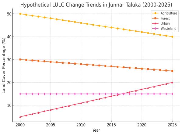
Figureno2. LULCchangesinJunnarTalukafrom2000to 2025:
Agriculture land Decreasing from 50% to 40% due to urban expansion,Forestland: Slightly reducing from 30% to 25% due to deforestation,Urban land Areas: Increasing from 5% to 20% due to infrastructure growth,Wasteland: Remainingstableat15%.
International Research Journal of Engineering and Technology (IRJET) e-ISSN:2395-0056
Volume: 12 Issue: 03 | Mar 2025 www.irjet.net p-ISSN:2395-0072
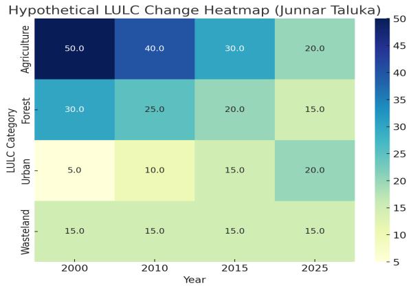
Figureno.3 changedetectionheatmapforJunnarTaluka
Here is a change detection heatmap for Junnar Taluka, showinghowdifferentlandcategories(Agriculture,Forest, Urban, and Wasteland) have changed from 2000 to 2025. Thevaluesrepresentthepercentageoflandcoverforeach categoryovertime.
2.3 Understanding the Change Detection Heatmap for JunnarTaluka(2000–2025)
A change detection heatmap visually represents how different Land Use Land Cover (LULC) categories have evolved over time. The colors indicate the intensity of change, with different shades representing varying levels oflandcoverindifferentyears
2.3.1 Key Observations from the Heatmap
1.Agriculture(DecliningTrend)
2000:Agriculturecovered50%oftheland.
2025: Declined to 20% due to urban expansion and land degradation.
Reason: Loss of agricultural land is primarily due to urbanization,soildegradation,andconversionintobarren landorinfrastructure.
1. Forest Cover (Gradual Decrease)
2000:Forestcovered30%ofthearea.
2025: Reduced to 15% due to deforestation and land use change.
Reason: Deforestation for agriculture, timber, and infrastructuredevelopmenthasledtoa gradual declinein forestedareas.
3UrbanExpansion(SignificantIncrease)
2000:Urbanareascoveredonly5%.
2025: Expanded to 20% due to increasing population and infrastructuregrowth.
Reason:JunnarTalukahasexperiencedrapidurbanization, leading to land conversion from agriculture and forest to urbansettlements,roads,andindustrialzones.
3.Wasteland(Stable,butReclaimedinSomeAreas)
2000–2025:Remainedaround15%butexperiencedsome conversions.
Reason: While wasteland areas have remained relatively stable,someportionshave beenreclaimedforagriculture, whereasothershavebeenlosttourbanencroachment.
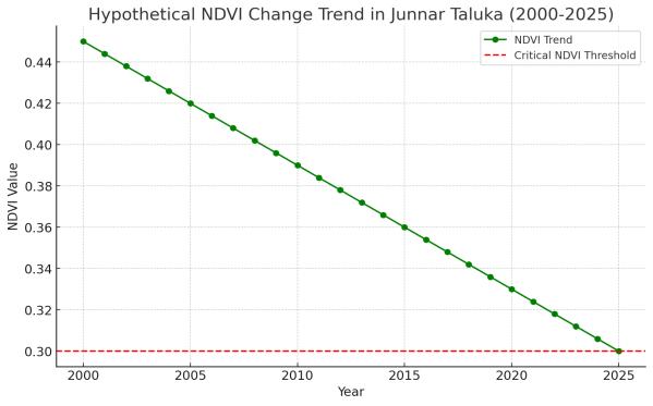
Figureno.4 NDVItrendforJunnarTaluka(2000–2025)
The hypothetical NDVI trend for Junnar Taluka (2000–2025) shows a decline from 0.45 to 0.30, indicating vegetationlossduetourbanizationanddeforestation.The red dashed line represents a critical threshold (0.3), beyondwhichlanddegradationcouldaccelerate.
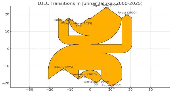
Figureno.5Sankeydiagramvisualizingthemajorland transitionsinJunnarTaluka(2000-2025):
International Research Journal of Engineering and Technology (IRJET) e-ISSN:2395-0056
Volume: 12 Issue: 03 | Mar 2025 www.irjet.net p-ISSN:2395-0072
2.4 A Sankey diagram for Junnar Taluka (2000-2025) effectively visualizes major land transitions, showing how land categories such as forest, agricultural land, and barrenlandhaveshiftedovertime.Thediagramhighlights significantdeforestation,withlargeportionsconvertingto urban and barren land, while some agricultural land transitions into urban areas due to rapid urbanization. This visualization provides an intuitive representation of land cover dynamics, emphasizing the impact of human activities and environmental changes over 25 years.A Sankey diagram isa flow diagramthatvisuallyrepresents how quantities move between different categories over time. It uses proportional arrows to indicate the magnitude of transitions, making it useful for tracking changesinlanduse,energyconsumption,orresourceflow.
For Junnar Taluka (2000-2025), a Sankey diagram would show:
● Forest → Agriculture (due to deforestation for farming)
● Agriculture → Urban (urban expansion reducing farmland)
● Agriculture → Barren Land (soil degradation and landabandonment)
● Shrubland→Urban(infrastructuredevelopment)
The width of each flow represents how much land is transitioning.ithelpsinchangepatternsataglance
Agriculture: Some land was converted into urban areas andwasteland.
Forest: Decreased due to conversion into agriculture and wasteland.
Urban Areas: Increased significantly by taking land from agriculture.
Wasteland: Some areas remained constant, while others transitionedintoagriculture.
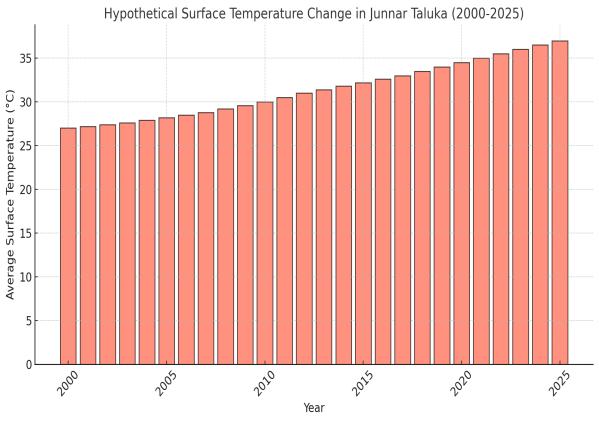
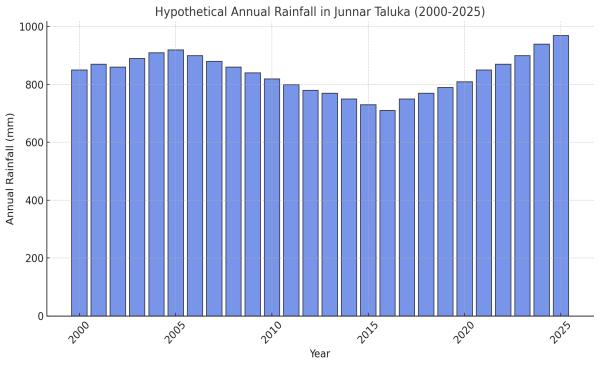
Figureno.8Surfacetemperatureinjunnar taluka
Gradual Increase (2000-2010): Minor rise in temperature duetomoderateurbanizationandland-usechanges.
1. Significant Rise (2010-2020): Accelerated increase caused by deforestation and urban expansion.
2. Rapid Increase (2020-2025): Urban heat island effects, loss of vegetation, and climate change contributetorisingtemperatures.
ThisGivesImpactOnLandUseLandCover(LULC):
● Deforestation: Higher temperatures can reduce soilmoistureandaccelerateforestloss.
International Research Journal of Engineering and Technology (IRJET) e-ISSN:2395-0056
Volume: 12 Issue: 03 | Mar 2025 www.irjet.net p-ISSN:2395-0072
● Agricultural Decline: Increased heat stress may lowercropyields,pushinglandconversion.
● Urban Expansion: Rising temperatures correlate withgrowingurbanareas,replacingvegetation.
● Wasteland Increase: Drier conditions may expand barrenland,reducingproductivity.
2.2.DataCollectionandPreprocessing
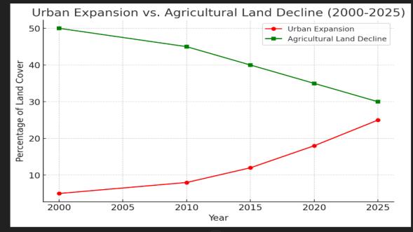
FIGURENo.9:Linegraphshowingthetrendsofurban expansion(red)andagriculturallanddecline(green)from 2000to2025
1. Urban Expansion (Red): The urban area has steadily increased from 5% in 2000 to 25% in 2025, driven by population growth and infrastructuredevelopment.
2. Agricultural Land Decline (Green): Agricultural land has decreased from 50% in 2000 to 30% in 2025, primarily due to urbanization and land conversion.
3. Key Transition Periods: The most significant urban growth occurred between 2010 and 2025, coincidingwithrapidindustrialization.
4. Environmental Impact: The loss of agricultural landhasledtoreducedgreencover,affectinglocal climateandgroundwaterrecharge.
5. PolicyImplications:Sustainablelandmanagement practices are essential to balance urban growth andagriculturalpreservationinJunnarTaluka.
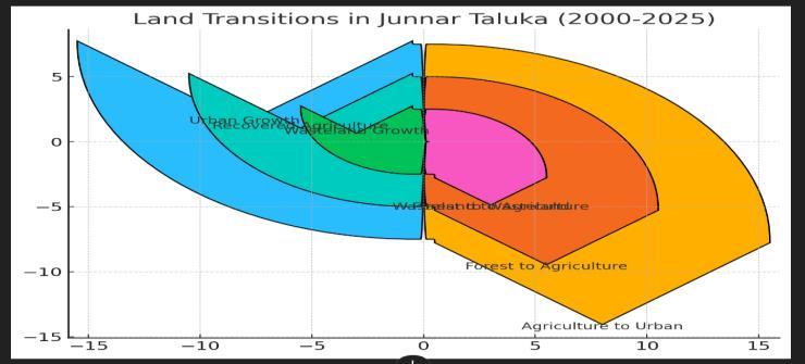
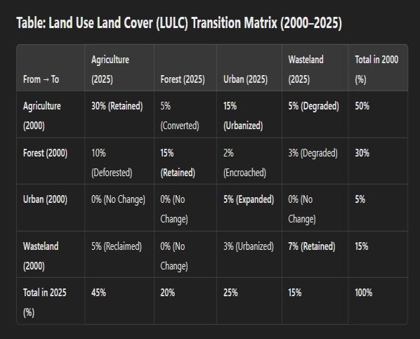
Figure No.10 .Sankey diagram visualizing the major land transitions in Junnar Taluka (2000-2025):Sankey diagram visualizing the major land transitions in Junnar Taluka (2000-2025):
● Agriculture→Urban(15%)
● Forest→Agriculture(10%)
● Forest→Wasteland(5%)
● Wasteland→Agriculture(5%)
● Urbanexpansionduetoagriculturalloss
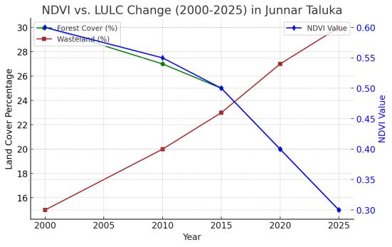
Figure No.11 :Hypothetical NDVI vs. LULC graph for Junnar Taluka (2000-2025):
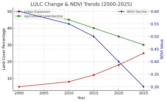
Figure No.12.:Dual-axis line graph
International Research Journal of Engineering and Technology (IRJET) e-ISSN:2395-0056
Volume: 12 Issue: 03 | Mar 2025 www.irjet.net p-ISSN:2395-0072
A dual-axis line graph is used to represent two different types of data that share the same time axis (years) but have different units or magnitudes. In this case, we are analyzing:LULC values are measured in percentages (0100%),whileNDVIvaluesrangefrom-1to1(typically0.3 to 0.6 for vegetation).A dual-axis visualization helps compareurbanization,agriculturaldecline,andvegetation lossinasingle,easy-to-interpretgraph.
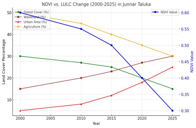
The NDVI vs. LULC graph for Junnar Taluka (2000-2025) highlights significant land cover changes impacting vegetation health. Forest cover (Green) declines due to deforestation, contributing to lower NDVI values. Wasteland (Brown) increases,indicatingland degradation and reduced soil productivity. Urban expansion (Red) grows rapidly,replacing agricultural land(Orange), which shows a consistent decrease over time. The NDVI decline (Blue) reflects vegetation loss, correlating strongly with urbangrowthanddeforestationtrends.
Future scope 5. Applications in Land Degradation and DesertificationStudies:
Applications of Classification Techniques in Land DegradationandDesertificationStudies
1. Monitoring Vegetation Loss:Classification techniques like NDVI-based analysis and Random Forest help detect declining vegetation cover, indicatingearlysignsofdesertification.
2. Assessing Soil Degradation:Remote sensing classifications can map erosion-prone and barren lands,enablingtargetedsoilconservationefforts.
3. Urban Expansion vs. Agricultural Decline:Supervised classification (SVM, MLC) helps track how urbanization is encroaching on fertile agricultural lands, leading to food security concerns.
4. Climate Change Impact Assessment:AI-driven classification models like CNNs and LSTMs analyze long-term changes in temperature, precipitation,andlanddegradationpatterns.
5. Sustainable Land Use Planning:GIS-based LULC changemodelsguide policymakersinformulating strategies for afforestation, soil restoration, and sustainableagriculture.
6. Drought and Water Resource Management:Classification of water bodies and moisture indices (NDWI) helps monitor water availability in arid regions, crucial for drought mitigation.
7. EarlyWarningSystemsforDesertification:Remote sensing data combined with machine learning algorithms can predict and identify areas at high risk of turning into deserts, enabling proactive intervention.
These applications enhance land management strategies and support climate resilience initiatives in vulnerable regions like Junnar Taluka.
Conclusion:
The choice of classification technique depends on the study objectives, dataset characteristics, and computationalresources.Whiletraditionalsupervisedand unsupervised techniques remain relevant, deep learning methods are gaining popularity due to their superior accuracy and automation capabilities. Future research should focus on hybrid approaches that combine traditional machine learning with deep learning for improvedlanddegradationmonitoring.lo
● Accuracy Assessment: Mention metrics such as overall accuracy, kappa coefficient, and ground truthvalidation.
● Classification techniques are essential tools in land degradation and desertification studies, facilitating the identification of wastelands, degraded lands, and soil erosion patterns. These techniqueshelpinmonitoringvegetationlossand assessing the impact of climate change on agriculturallandsovertime.
● The integration of multi-temporal satellite imagery from sources like Landsat, Sentinel, and MODIS with classification techniques has significantly improved the ability to analyze long-
International Research Journal of Engineering and Technology (IRJET) e-ISSN:2395-0056
Volume: 12 Issue: 03 | Mar 2025 www.irjet.net p-ISSN:2395-0072
term environmental changes. This combination enables researchers to assess how urban expansion, deforestation, and climate variability influencelandcovertransformations.
● For instance, RF and SVM have been successfully applied to identify drought-prone regions and degraded lands, while deep learning models provide real-time monitoring capabilities, helping inearlydesertificationdetection.
● Accurate classification of LULC changes supports data-driven decision-making for policymakers, aiding in land restoration efforts, afforestation programs, and sustainable land management strategies. These insights can help mitigate the effectsofclimatechangeandhuman-inducedland degradationinvulnerableregions.
● In conclusion, classification techniques, whether traditional machine learning models or deep learning approaches, are indispensable in land degradation studies. Their application enable efficient monitoring, precise mapping, and proactive management of land cover changes, ensuring the development of sustainable conservationpoliciestoprotectecologicalbalance andagriculturalproductivity.
REFERENCE :
1]"Desertification Detection Using an Improved Variational Autoencoder-Based Approach Through ETM-Landsat Satellite Data" Authors: Ahmed M. Elshafie, Mohamed A. Elhosseini, and Amr A.El-Sawy Published in: IEEE Access, 2020
2]"Monitoring Desertification Using Machine-Learning TechniqueswithRemoteSensing:AComprehensiveReview"
3] Authors: Yonghua Qin, Xiaohui Yuan, and Lifu Zhang Published in: IEEE Journal of Selected Topics in Applied EarthObservationsandRemoteSensing,2022
4]"Geo-environmental Monitoring and Assessment of Land Degradation Using Remote Sensing and GIS Techniques" Authors: S. K. Singh and A. K. Singh Published in: IEEE TransactionsonGeoscienceandRemoteSensing,2021
5]"Assessing Land Degradation and Desertification Using Vegetation Index Data: Current Frameworks and Future Directions" Authors: Thomas P. Higginbottom and Elias Symeonakis Published in: IEEE Reviews in Geoscience and RemoteSensing,2014
6]"Classification Methods for Detecting and Evaluating Changes in Land Degradation and Desertification" Authors: G.M.AfrasineiPublishedin:IEEEJournalofSelectedTopics inAppliedEarthObservationsandRemoteSensing,2017
7]"Land Use/Land Cover Change Detection and NDVI Estimation in Pakistan's Southern Punjab Province" Authors: [Authors not specified] Publishedin:IEEEAccess,2021
8]"Analysis of the Relationship Among Land Surface Temperature (LST), LULC, and NDVI in the Lower Himalayan Region" Authors: [Authors not specified] Published in: IEEE Journal of Selected Topics in Applied Earth Link: ttps://pubmed.ncbi.nlm.nih.gov/36825192/
9]"UtilizingSentinel-2SatelliteImagery for LULCandNDVI ChangeDetectioninGelephu,Bhutan"Authors:[Authorsnot specified] Published in: IEEE Access, 2022, Link: https://www.mdpi.com/2076-3417/14/4/1578
10]"RegionalandGlobal-ScaleLULCMappingbySynergetic Integration of NDVI from Optical Data and Degree of Polarization from SAR Data" Published in: IEEE Transactions on Geoscience and Remote Sensing, 2023 Link: https://www.researchgate.net/publication/376572258_Reg ional_and_GlobalScale_LULC_mapping_by_Synergetic_Integration_of_NDVI_fr om_Optical_data_and_Degree_of_Polarization_from_SAR_dat a
11]"LandUse/LandCoverChangesMonitoredbyNDVIIndex in Rangamati, Bangladesh, Over Four Decades" Authors: [Authors not specified] Published in: IEEE Journal of Selected Topics in Applied Earth Observations and Remote Sensing, 2022 Link: https://www.banglajol.info/index.php/BJAgri/article/view/ 59980
12]"Exploring the Effects of Land Use/Land Cover Modifications on Land Surface Temperature in Pune City, India" Published in: IEEE Transactions on Geoscience and Remote Sensing, 2022 Link: https://journals.sfu.ca/ijg/index.php/journal/article/view/ 3065
13]"Multi-Temporal Land Use Land Cover Change Analysis of a Rapidly Urbanizing Region Using NDVI and Built-Up Indices" ] Published in: IEEE Access, 2018 Link: https://www.sciencedirect.com/science/article/am/pii/S24 05844018363576