International Research Journal of Engineering and Technology (IRJET) e-ISSN: 2395-0056

Volume: 09 Issue: 09 | Sep 2022 www.irjet.net p-ISSN: 2395-0072
International Research Journal of Engineering and Technology (IRJET) e-ISSN: 2395-0056
Volume: 09 Issue: 09 | Sep 2022 www.irjet.net p-ISSN: 2395-0072
Abhishek Chack1 , Ankit Kumar2
1 PG Student, MUP, Dept. of Architecture, M.I.T.S, Gwalior (M.P)
2Assistant Professor, Dept. of Architecture, M.I.T.S, Gwalior (M.P)***
Abstract - Understanding human settlement patterns is the focus of urban planning, an interdisciplinary field. Planning is a highly specialized and small discipline that draws on design (for example, architecture), policy (for example, public administration), and social science (e.g., geography). With urban planning interests spanning several disciplines, we suspect a shifting topic hierarchy over time. Among these are, but are not limited to, shifting perspectives on infrastructure policy, architecture, social conditions, environmental conditions, economic activity, and governance, all of which are important aspects of urban systems. Not all of these receive equal attention over time, as certain concerns or interests are more visible at different times than others. These interests, according to the public, are driven by changing policies or politics, as well as the flow of information from sources such as the news media.
Key Words: Lucknow,SocialInfrastructure,HealthSystem,EducationFacility.UrbanLinkages.
LucknowisthecapitaloftheIndianstateofUttarPradesh,aswellasthedistrictheadquartersoftheLucknowdistrictanda politicallywell-knownconstituencyinIndia [1].Thereare609slumsinthecity,with148117households.Thereare502 notifiedslumsand107unnotifiedslumsoutofthetotalof502slums.Slumshousearound27%ofthecity'spopulation.77%of theslumpopulationbelongstotheOBCandSCsocioeconomiccategories,while69%livebelowthepovertylevel(BPL)[2]
ThephysicalcharacteristicsofLucknowcityaredescribedasfollows.
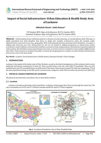
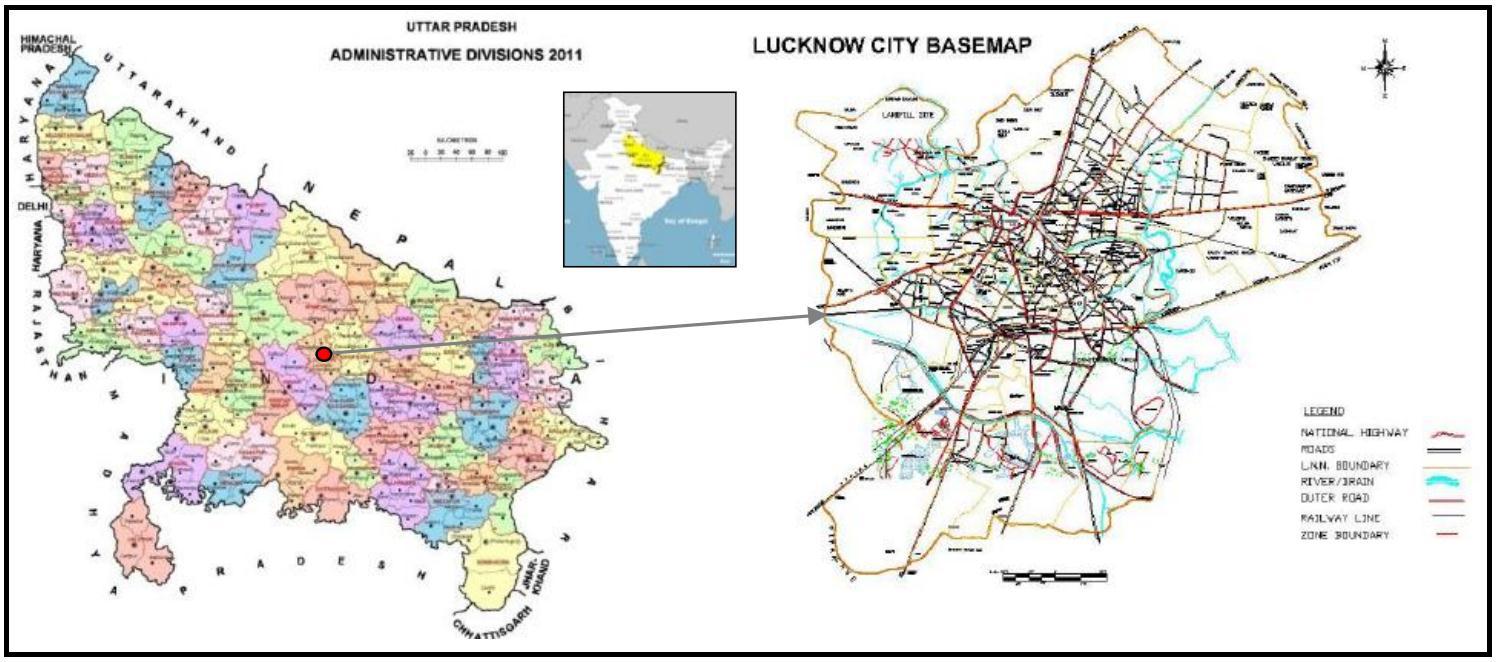
LucknowislocatedonthebanksoftheGomtiRiver,atributaryoftheGangesRiverthatrunsthroughthecentralcity.The city'scoordinatesare26°30'and27°10'NorthLatitudeand80°30'and81°13'EastLongitude.
Fig-1: LocationofLucknowcityinUttarPradeshState
International Research Journal of Engineering and Technology (IRJET) e-ISSN: 2395-0056
Volume: 09 Issue: 09 | Sep 2022 www.irjet.net p-ISSN: 2395-0072
LucknowislocatedintheGangeticplainsonareasonablycompactareaofgentlyslopingground.Thelargestgeological formationistheAlluviumsoils.TheclimateintheareaisCompositeTropical.Theelevationofthecityis123.45metresabove sealevel.TheGomtiRiveranditstributariesdrainthecity.ThecityislocatedinSeismicZone-III1,whichisclassifiedasa moderatedamageriskzone[3].
Lucknowhasanintensetropicalclimate,withchillyanddrywintersfromDecembertomid-Februaryandhot,drysummers fromApriltomid-June.Therainyseasonlastsfrommid-Junetomid-September,withanaveragerainfallof1000mm,caused primarilybythesouth-westmonsoonwinds.Duringtheintensewinter,thehighesttemperatureisapproximately25degrees Celsius,whilethelowesttemperatureisfrom3to4degreesCelsius.FromlateDecembertolateJanuary,fog isextremely prevalent.Summersmaybefairlyhot,withtemperaturesreaching40to45degreesCelsius[4].
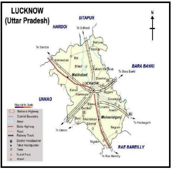
TheLucknowdistrictissurroundedontheeasternsidebyDistrictBarabanki,onthewesternsidebydistrictUnnao,onthe southernsidebyRaebareliandonthenorthernsidebySitapurandHardoidistricts.Lucknowiswellconnectedtotheother partsofstateandcountrythroughair,railandroad.FourNationalHighwayspassthroughthecity,theNationalHighway(NH) 24linkingLucknowtoDelhi,NH25toShivpuri,Jhansi(MadhyaPradeshBorder),NH56linkingtoVaranasiandNH28to Mokama (Bihar) connecting different regions within and outside the state are passing through the city. In terms of rail connectivity,LucknowRailwaystationisamajorjunctionhavingtworailwayterminalswhereonebelongstoNorthernRailway divisionandanotherbelongstoNorthEasternRailwaydivisionconnectingallthemajorcitiesofthestateandthecountrysuch asNewDelhi,Mumbai,Kolkata,Hyderabad,Bengaluru,Chennai,Ahmadabad,JaipurPuneetc.Apartfromthemainrailway stations,thecityhasthirteenrailwaystationsatdifferentpartsofthecitywhicharewellconnectedtothesuburbanareasofthe city[5].TheChaudaryCharanSinghInternationalAirportissituatedatAmausi,10kmfromLucknowRailwayStation.Itisthe secondbusiestairportinNorthIndiaaftertheIndiraGandhiInternationalAirport,Delhi.Lucknowisdirectlyconnectedbyair with Sharjah, Dubai, Muscat, Riyadh and major cities in country such as Delhi, Mumbai, Dehradun, Hyderabad, Chennai, Bengaluru,Kolkata,Ahmedabad,Bhubaneswar,Bhopal,Patnaetc.AlongwithLucknowtheairportservesasprimaryaviation hubforKanpurcity.
International Research Journal of Engineering and Technology (IRJET) e-ISSN: 2395-0056
Volume: 09 Issue: 09 | Sep 2022 www.irjet.net p-ISSN: 2395-0072
Fig-3: ConnectivityofLucknowwithotherstates
ThepopulationofLucknowcity(NagarNigam)asper2011censusis28,15,601outofwhichmaleandfemaleare14,70,133 and13,45,468respectively.Consideringthepopulationstatisticsfromthelastcentury,thecityfacedadecreaseinpopulationin thedecade1911-1921andthereafterthedecadalpopulationincreasedsuccessively.Thedecade1981-1991showedanincrease inthedecadalrateof70.79duetothereasonsofexpansionofcityarealimit.Thedecalpopulationgrowthratein2001-11is 28.81percent(asshownintable1).Thepopulationofchildren(0-6yrs)ason2011inLucknowis2,80,817whichconstitutes about9.97percentoftotalpopulation[6]
S.No. Census Year Population Decadal Population Increase (In No.) Decadal Population Growth Rate (%) 1. 1901 256239 2. 1911 252114 -4125 -1.61 3. 1921 240566 -11548 -4.58 4. 1931 251057 10491 4.36 5. 1941 361294 110237 43.91 6. 1951 459484 98190 27.18 7. 1961 615523 156039 33.96 8. 1971 774644 159121 25.85 9. 1981 947990 173346 22.38 10. 1991 1619116 671126 70.79 11. 2001 2185927 566811 35.01 12. 2011 2815601 629674 28.81
Table-1: DecadalgrowthtrendofLucknowcitypopulation
International Research Journal of Engineering and Technology (IRJET) e-ISSN: 2395-0056
Volume: 09 Issue: 09 | Sep 2022 www.irjet.net p-ISSN: 2395-0072
EconomicliteratureisrichwithstudiesontheeducationandhealthsectorinIndiaidentifyingproblemareasproviding solutionsestimatinginvestmentrequirementinvestmentrequirements,makingrecommendationsforpolicyandinstitutional changes[6].
Governmentsatthenationalandstatelevelshavebeentraining,maybemoresointhelasttwodecades,toconnectthe objective of universal primary education to their agendas. The federal government's recent all-India activities are mostly discussed.The73rdand74thconstitutionalamendmentsemphasizedtheroleoflocalgovernments,bothruralandurban,inthe supplyandregulationofeducation,aswellasthedevelopmentofcultural,educational,andaestheticelements[7].
TheIndiangovernmentinitiatedaninitiativein1994toachievetheaimofuniversalprimaryeducation.Theprogrammed was undertaken with a completely new strategy of district-specific planning, decentralized management, and community engagement, empowerment, and capacity building at all levels. In 2001, the central government began the Sarva Shiksha Abhiyan.The93rdAmendmenttotheConstitutionof2002mandatedfreeandcompulsoryeducationforallstudentsaged6to 14.Itisundoubtedlyinferiorinruralregions,buteveninmetropolitanareas,infrastructurefallswellshortofacceptablelevels. Thedeteriorationofschoolbuildingsisthemostvisibleexampleofthis.AccordingtotheSeventhAllIndiaSchoolEducation Survey2002(NCERT,2002),around84%ofprimaryschoolsinmetropolitanareasoperatedfromapuccabuildingwithenough classroomsforinstructionandapproximately2%inopenspace.Economicvariablesplayalessroleindeterminingderivationin urbanregions,butsocialclassesaremoreimportantinruralplaces[8]
Inthecaseofbothmaleandfemalepopulationsinsecondaryschoolattendanceage,nomorethan50%ofthemprogress fromthemiddletosecondarylevelofeducation.Theproblemisexacerbatedwhenjust38.55%ofruralgirlsprogressfrom middletosecondaryschool.Thetransitionrateisdirectlyrelatedtoagroup'seconomicwell-being.Thehighertheeconomic standing,thefasterchildrentransferfrommiddletosecondaryschool.Whilethetransitionrateforthelowestquintileis31.66,it is13.08forthehighestquintile,implyingthatahousehold'seconomicwell-beingappearstohaveasignificantinfluencein continuingstudiestoahigherlevel.
Thetransitionalgradeinequalitieshavesevereimplicationsforfutureequalitylevels.AccordingtotheWorldBankStudy (2002),impoverishedparentsnotonlyappreciatetheneedofeducationfortheirchildren,buttheyarealsoreadytoinvest limitedresourcesintheirchildren'seducation.However,acomplicatedcollectionofcircumstancesworkagainstthem.Thefear isthatenrolment,attendance,completion,andlearningoutcomesarebecominglargerdifficulties.Thereismountingevidence thatprivateschoolsareproliferatingthroughoutthecountry,andthatchildrenarebeingsenttoprivateschoolsiftheirparents canaffordthem.Someparentschoosetosendtheirchildrentoprivateschoolseventhoughtheycannotaffordit.
AccordingtotheUNDP'sHumanDevelopmentReport2001,Indiaranksamongthebottomfortycountriesintermsofgeneral humandevelopmentindicators.OfthemanymeasuresthatcontributedtoIndia'spoorperformance,healthindicatorswere amongthelowest,whichisnotsurprisinggiventhecountry'shighpovertylevelsandclimateconducivetodiseasevictimization. Life expectancy, malnutrition, the incidence of dangerous illnesses, and vaccination levels are all important markers of a country'shealth.ThesemetricsdiffersignificantlyamongstatesinIndia.Therearesignificantdistinctionsbetweenruraland urbanlocations.Ithasbeendiscoveredthattheimpoverishedaremorepronetosicknessanddeath,andsohaveashorterlife expectancy.Nutritionalinadequacies,aswellasalackofaccesstoessentialutilitiessuchassafedrinkingwater,sanitation, health,andeducationservices,canallcontributetoillnessanddeath.However,thegendergapinlifeexpectancyremainsbelow theinternationalaverage(IndicusAnalytics,2004)[9]
DuetotheobviousfederalaspectoftheIndianSystem,healthcareservicesareseparatedintotwocategories:statelistand concurrent list. While certain items, such as public health, hospitals, and sanitation, are on the state list, others, such as population control andfamily welfare, medical education, foodadulteration prevention, and qualitycontrol inmedication
International Research Journal of Engineering and Technology (IRJET) e-ISSN: 2395-0056
Volume: 09 Issue: 09 | Sep 2022 www.irjet.net p-ISSN: 2395-0072
manufacturing,areontheconcurrentlist.TheunitedMinistryofHealthandFamilyWelfareistheprimaryauthorityinchargeof implementingnumerousprogrammesandplansinthefieldsoffamilywelfare,illnessprevention,andcontrol.Municipalitiesand districtadministrationsareresponsibleforinfrastructureandservicesinmetropolitanareas.Themajorityofhighereducation institutionsinthenationarealreadyoperatingintheprivatesector.However,thevastmajorityofthemareprivateaided schools,whichareequivalenttogovernmentinstitutionsintermsofwages,rules,andprocesses.Otherclassificationssuggest thatthesignificanceofprivateaidedschoolsisprogressivelyfadingovertime.Privateandindependentschoolsarebecoming increasinglysignificantatalllevelsofeducation[2]
Privateschoolsinelementaryschoolsweremostlyconcentratedinmetropolitanareas.In1993-4,morethanathirdofall elementaryschoolsinmetropolitanareaswereprivate.Becauseaidedschoolsarerareattheelementarylevel,itislikelythatthe majorityofthesewereprivateunassistedprimaryschools.However,around5%werealsopresentinruralregions.Aswe progressthroughtheeducationallevels,theproportionofprivateschoolsinruralregionsgrows.Privateschools,forexample, makeforthebulkofuppersecondaryschoolsinremoteregions.
Thegrowthmateofprivateunaidedschoolsishigherthantheprivateaidedandthepublicones.
Thegrowthofprivateschoolsispredominantatthehigherlevels;however,privateunaidedschoolshavewitnessedrapid growthatalllevels.
Privateschoolstendtobelesserinnumberintheruralareas.However,theshareofprivateschools(aided&unaided) increasessteeplywithrisinglevelsinruralareasascomparedtotheurbanareas.
Lucknow is also an important research and development (R&D) and educational centre. In terms of the number of institutions, the city is among the top in India, with seven universities, one technical university, and a huge number of polytechnics,engineeringcolleges,andindustrialtraininginstitutes.Someofthewell-knowneducationalinstitutionsarethe SanjayGandhiPostGraduateInstituteofMedicalSciences,KingGeorgeMedicalCollege,IndianInstituteofManagement,Dr. RamManoharLohiyaNationalLawUniversity,andLucknowUniversity[2,4]
HoweverapartfromtheNationalMilkGridoftheNationalDairyDevelopmentBoard,prominentR&Dcentresinthecity include the Central Drug Research Institute (CDRI), Central Institute of Medical and Aromatic Plants (CIMAP), Industrial ToxicologyResearchCentre(ITRC),NationalBotanicalResearchCentreInstitute(NBRI),NationalHandloomDevelopmentLNN (NHDC)Ltd.,PradeshikCooperativeDairyFederationLtd(PCDF),andResearchDesignandStandardsOrganization(RDSO). Sincethecityservesasboththestate'scapitalandthedistrict'sadministrativeheadquarters.Manyhospitalsandinstitutes,both publicandprivate,arelocatedinthecity.TheKingGeorge,SanjayGandhiInstituteofMedicalSciences,RaniLaxmibaiState Hospital,RamManoharLohiaHospital,StateAyurvedic,andStateHomeopathyhospitalsarewell-knownstate-runinstitutions inthecity[3,6].
Theoutcomeofthisworkareasfollows:-
Lucknowhasdevelopedasakeysiteforthestate'seducationalinstitutions.Lucknowiswell-connectedtomostof India'smainmetropolitancities,includingMumbai,Hyderabad,Bangalore,Delhi,Kolkata,andChennai,aswellasall significantcitiesandtownsinUttarPradesh.
Despiteincreasedtourism,thecityboastsarichpastandnaturallandscape.Lucknow'scorecityareahasastrong traditionalcharacterthathasthepotentialtobepreservedandrestored.
Toavoidtrafficconcerns,newdevelopmentareasincludebroadroadwaysandwell-definedintersections.Therelevant authoritiesareactivelystrivingtoimprovethecity'spublictransportation.
Rapidurbanization,populationgrowth,growingeconomyoftheregionhasplacedanenormousstrainonthecity's infrastructure.
Greenareasinthecityarenotincreasingascomparedtoresidentialarea.
International Research Journal of Engineering and Technology (IRJET) e-ISSN: 2395-0056
Volume: 09 Issue: 09 | Sep 2022 www.irjet.net p-ISSN: 2395-0072
Haphazarddevelopmentpatternandencroachmentsareseeninthenewdevelopedareasofthecity.
Highlycongestedroadsinthecoreofthecity.
Highvolumecapacityratioinallthemajorroads.
Lackofpedestrianfacilitiesinalltheroads.
Lackoftrafficsenseamongthepublic.
Lucknowcityhaspotentialtobedevelopedaskeytouristdestination.
DuetocontinuousgrowthofthecitytheopportunityformoreinvestmentisincreasinginLucknow
AccordingtotheMasterPlan2021,variousparcelsoflandareavailablefornewdevelopmentandconstruction.Reliable and effective public transportation can help to reduce the number of individualised vehicles on the roads. The developmentofmetrorailandlocalrailsystemscanhelptotacklethepublictransportationissue.
Duetofastpaceofthecitygrowthalotofpressurebeingcreatedonexistingphysicalinfrastructureandtransportation system.
Theonlycityinthestatetoprovidebettereducation,healthandemploymentopportunitiestothepeopleresultingin hugeinmigrationandcontinuousgrowthofslums.
Ifcountermagnetswillnotdevelopinthenearfuturethecitywillfaceovercrowding.Highgrowthrateofpersonalize vehiclesisthreatforthecitytrafficsystem.Lackofoff-streetparkingspacescanleadtomoretrafficcongestioninthe future.
TheWorldHealthOrganization(WHO)summarizeswhyurbanhealthmattersinarapidlyurbanizingworld,withitsattendant opportunitiesanddifficulties.Whileurbanizationanditsinfluenceonhealthhavebeendiscussedperiodicallysincethe1980s, worldwidemomentumonadvocacy,research,andprogrammesfocusingexplicitlyonthehealthoftheurbanpoorinLow-and Middle-IncomeCountrieshasjustrecentlybegun.Therecouldbeavarietyofreasonsforthelackofpoliticalsupportforan urbanhealthagenda.Theseincludeapredominantlyrural-orienteddevelopmentagenda,littledataexplicitlydisaggregatedto assessthescaleandseverityofurbanhealthconcerns,andapaucityofevidenceonhowbesttoaddressthesechallengesaside fromalimitedsharedunderstandingoftheproblemitself.Indiaisnoexception,anditisonlyrecentlythatithasbeguntocatch upwithglobaltrendsinrecognizingthechallengeofurbanhealthandtheneedtoprioritiseit.
The study outlined the current state of educational infrastructure in secondary schools and health facilities in Lucknow. Accordingtothefindings,thereisstillaneedtoimproveeducationinfrastructureintermsofquantityandquality.Accordingto theresponders,severalinfrastructuresareinpoorshape.Studentsandinstructorsareinvolvedinthemonitoringandevaluation ofschoolinfrastructure.Theschool'sadministrationhasnowell-definedfinancialbudgetplanningforregularpreventativeand maintenance,andthesurveyfoundsomefurniturestrewnaboutuncontrolledinschoolgrounds.
[1] https://en.wikipedia.org/wiki/Lucknow
[2] https://www.hindustantimes.com/cities/lucknow-news/prepare-development-plan-for-lucknow-on-lines-ofmetropolitan-board-cm-101657045522327.html
[3] https://lmc.up.nic.in/pdf/Final%20CDP%20-%20Volume%20I.pdf [4] https://lmc.up.nic.in/CDP.aspx
International Research Journal of Engineering and Technology (IRJET) e-ISSN: 2395-0056
Volume: 09 Issue: 09 | Sep 2022 www.irjet.net p-ISSN: 2395-0072
[5] https://timesofindia.indiatimes.com/city/kanpur/logistics-plan-to-develop-city-and-lucknow-as-twincities/articleshow/90831720.cms
[6] https://www.researchgate.net/publication/264943381_Assessment_of_Land_Use_around_highly_populous_business_centr e_of_Lucknow_City_using_GIS_techniques_and_high_resolution_Google_Earth%27s_Quickbird_satellite_data/figures?lo=1
[7] https://uptownplanning.gov.in/post/en/introduction-of-development-area-lucknow
[8] https://www.jagran.com/uttar-pradesh/lucknow-city-master-plan-ready-to-make-lucknow-shine-lucknow-developmentauthority-will-spend-rs-500-crore-22643217.html
[9] https://www.masterplansindia.com/uttar-pradesh/lucknow/
Author1
Abhishek Chack borninGwalior,India.HereceivedtheB.Arch.DegreeofArchitecturein2011 fromMadhavInstituteofTechnologyandscience,Gwalior,India.HeiscurrentlypursingMUP from Madhav Institute of Technology and science, Gwalior, India. He is approachable at chackabhishek@gmail.com
Author2
Ankit kumar iscurrentlyworkingasanAssistantProfessorintheDepartmentofArchitectureat MITS,Gwalior(M.P.)India.Hehaspublishedvarious papersinInternationaljournalofArchitecture. Heisapproachableatkumarankeet@gmail.com