International Research Journal of Engineering and Technology (IRJET)
e-ISSN: 2395-0056
Volume: 09 Issue: 09 | Sep 2022
p-ISSN: 2395-0072
www.irjet.net
Spatial-Temporal Analysis of Land Use: Coimbatore Corporation, Tamil Nadu Ganeshmoorthi M, Dr. S. R. Nagarathinam 1Research
Scholar, Department of Geography, Govt. Arts College (Autonomous), Coimbatore, Tamil Nadu, India Professor and Head (Rtd.), Department of Geography, Govt. Arts College (Autonomous), Coimbatore, Tamil Nadu, India ---------------------------------------------------------------------***--------------------------------------------------------------------assess and monitor land use/land cover at different spatial Abstract - The study's main aim is to analyze the land use 2Associate
and multi-temporal levels [1].
changes of the Coimbatore Corporation for the period of 2011 and 2021. Coimbatore Corporation is located in Coimbatore district, Tamil Nadu state and its geographical area are 257.04 square kilometers. The temporal analysis was conducted using two satellite images and multiple vector data. ArcGIS Pro image classification and machine learning packages are used to capture building footprints and road networks. The satellite images are classified into four major classes: water bodies, agricultural land, built-up areas, and others. Further, the classified images were reclassified into nine urban land use classes. ArcGIS Pro ML-based segmentation and supervised classification method are used to classify images and capture vector data. The change detection analysis showed an increase in residential, Commercial, and Industrial areas due to raid urbanization.
1.1. Objective of the Study The objective of the study is:
1. INTRODUCTION Urban areas in the developing world are under consistently high pressure from the growing population. Rapid urbanization has a significant impact on the condition of the urban ecosystem and its surrounding suburban and rural areas. In India, urban areas are experiencing a highly accelerated pace of growth after independence. A variety of factors, such as the importance of locality, laws related to land, structure of the land, socioeconomic conditions, transportation facilities, market facilities, industrial development, investment pattern, cost of land, and local government economic policy, etc. influence the demand for land. However, the ever-increasing population influx in the urban areas and the physical expansion of the built-up area beyond the city limits are recognized as important factors contributing to raising the demand for more land as well as land use changes. Studying and understanding past and current land use help city planners prepare good development plans. Analysing the land use changes will provide future insights into land use trends for each category. GIS and Remote Sensing helps to build and monitor sustainable urban areas with the recent advancement in remote sensing, geographic Information System, computer technology, and programming languages. It is possible to
Impact Factor value: 7.529
Classify and Quantify the Land use change for 2011 and 2021
Analyse and evaluate the impact of land use changes in different land use classes and find the growth pattern
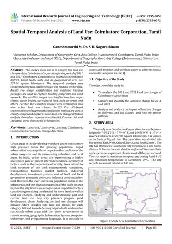
The study area Coimbatore Corporation located between longitude 76052’0”E - 7704’0” E and 10055’0”N -1107’0” N covers a total area of 257.04 square kilometers. It is located on the bank of Noyyal river. The coporation was divided into five zones (East, West, Central, North, and South Zones). The city has 100 wards. Coimbatore City experiences a sub-humid climate. It lies in the rain shadow region of Western Ghats and experiences a pleasant climate most all the years around. The city records maximum temperature during April 410C and minimum temperature in December 190C. The city records an annual rainfall of 611mm.
Coimbatore Corporation, Change detection
|
To analysis the 2011 and 2021 land use changes of Coimbatore corporation
2. STUDY AREA
Key Words: Land-use/Land-cover, Land use, Coimbatore,
© 2022, IRJET
Figure.1: Study Area Coimbatore Corporation
|
ISO 9001:2008 Certified Journal
|
Page 83