International Research Journal of Engineering and Technology (IRJET) e ISSN: 2395 0056

Volume: 09 Issue: 07 | July 2022 www.irjet.net p ISSN: 2395 0072
International Research Journal of Engineering and Technology (IRJET) e ISSN: 2395 0056
Volume: 09 Issue: 07 | July 2022 www.irjet.net p ISSN: 2395 0072
1J Maghrabi, 2P Rana, 3A Rakshe, 4S Kurane, 5A Morade
1 Assistant Professor, Department of Civil Engineering, 2, 3, 4, 5 Students, Department of Civil Engineering, Terna Engineering College, Nerul, Navi Mumbai 400 706 ***
Abstract WaterscarcityisthemajorissuefacedbytheworldanditisrapidlyrisinginIndia Toovercomethisproblem manymethodshavebeenadopted,interlinkingofriversisoneofthem Connectingtheriverswiththehelpofcanalsand reservoirsiscalledinterlinking InIndia,NationalWaterDevelopmentAgency (NWDA) haveproposedvariouslinksforthis purpose Amongst these link Daman Ganga (Ekadare) Godavari Valley link is selected and 4 alignments are proposed consideringvariousfactors QGISsoftwareisusedforthisproject
Keywords: Water,interlinking,rivers,canal,alignment,QGIS
WaterscarcityisamajorissuethatisrisingveryrapidlyinIndia Indiabeingwaterstressednation,isstandingonthebrinkof an acute water crisis The solutions proposed to solve the water scarcity problems are rainwater harvesting, water conservation,wastewaterrecyclingandmuchmore Theoneofthemajorsolutiontosolvethisproblemisinterlinkingof riverswhichwasintroducedintheyear1982inIndia TheInterlinkingofRiversistheconceptofconnectingtheriversofthe countrybynetworksofreservoirsandcanals. Throughinterlinking,watercanbetransferredfromelevatedsurplusareasto low lyingdeficitareas.Interlinkingofriversconsistsofmultifaceteddataonagrarian,environmental,hydrogeological,political andsocio economicaspects. Dataisderivedfromavarietyofsources,includingremotesensingphotos,aerialphotography, papermaps,andfielddata Foreasyretrieval,analysis,effectiveplanningandexecutionanddecisionmakingonsuchcomplex projectissues,thedataandinformationrelatedtoitshouldbestoredindigitalformatoneplace.
AkrutiKPateletal, (2015): TheyproposedtheplanningofinterlinkingofRiverShetrunjiandRiverDhatarwadibyacanal usingRemoteSensingandGIS TheslopemapandcontourmapwerepreparedwiththehelpofARCGISsoftware Thecanal alignment is planned based on the data acquired in such a way that the surplus water from Shetrunji Dam flows to the DhatarwadiDambygravitylevelpassingthroughthethreetalukas.Threecrossdrainageworksarerequiredbecausethecanal crossesthenaturalstreamsoftheBagadRiver,MalanRiver,andZolapurRiver.
HeenaKKanjanietal,(2016): SheconductedacasestudytoproposetheinterlinkingcanalalignmentfromKandanaDamto WatrakDamwhichislocatedinthenorthernpartofGujaratusingRemoteSensingandGeographicalInformationSystem(GIS). The satellite image data and geo spatial data were obtained from the BISAG and thematic layers were made using visual interpretation technique of ARC GIS Three alignment of canals were proposed based on the IS code of lined canal Consideringeconomy,suitabilityandlanduserequirementthatisbasedonGISstudy;approximately38kmlengthofinterlink canalhasbeenproposed Thewaterthroughthecanalwillflowwiththehelpofgravitypassingthroughloamysoil
Anupriya etal, (2018): Using GIS and Open Source Maps, they investigated the Vidarbha region (OSM). The topography characteristicsandpotentialofwaterstoragecapacitywithwatershadingoftheVidarbharegionwereanalysedusingQGIS 2.14.12withgrass7.2.0andCgiar csi. Thesoftwareswereusedtocreatethevariousdataneededforthelinkage. Examining suchanenvironmentalissuewithsoftwareprovestobeasignificantstepintherightdirection
a) ThecoreobjectiveoftheprojectistoanalyzethemostsuitablepathforinterlinkingofDamangangaRiverandGangapur ReservoirusingtheQGISsoftware
International Research Journal of Engineering and Technology (IRJET) e ISSN: 2395 0056
Volume: 09 Issue: 07 | July 2022 www.irjet.net p ISSN: 2395 0072
b) TofindouttheproposedlocationofdamnearEkadare c) Todivertthesurpluswaterusingcanal,ductsanddrainstoincreasetheareaunderirrigation
NWDAhascarriedoutstudiesandproposeddiversionofsurpluswateravailableatdependableyieldofDamangangabasin uptoproposedEkadaredamsitetoexistingGangapurreservoirinGodavariValley
Damanganga:TheDamanGangaoriginatesintheSahyadrihillsnearAmbegaonvillageintheDindoritalukaofMaharashtra's Nasikdistrict MajorpartoftheriverliesinMaharashtra Itis131 30kmlongfrompointoforigintotheArabianSea 20°19′N, 72°50′Earethecoordinates Dawn,Shrimat,Val,Rayte,Lendi,Vagh,andDudhniareimportanttributariesoftheDamanganga River
GodavariValley:TheUpperGodavarisub basin,whichliesbetween18°42'and20°28'northlatitudeand73°26'to77°46'east longitude,includestheGodavari'sreachfromitssourcetoitsconvergencewiththeManjraRiverbutexcludesthePravara, Purna, and Manjra rivers' catchment areas The river flows through Nashik district, eventually reaching the Gangapur Reservoir,whichwascreatedbyadamofthesamename,andsubsequentlytheKashyapiDam TheKashyapidamrises4175 mabovethelowestfoundation Thegrossstoragecapacityis0 05269km3andthevolumecontentis0 05174km3
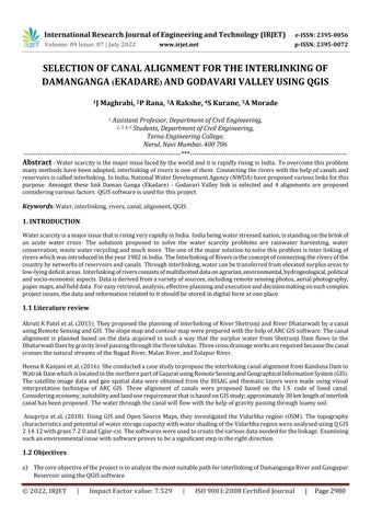
2 2 Flowchart
Fig 1: MethodologyFlowchart
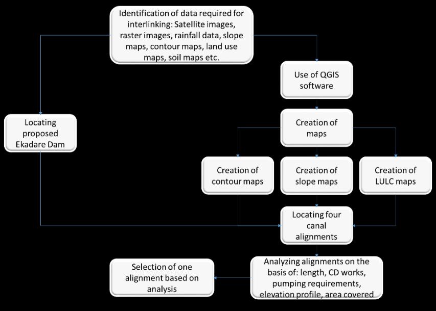
Figure1givestheflowchartonmethodologyusedinthestudy
ItisproposedtobuildanewdamontheDamangangaRivernearEkadarevillageinNashikdistricttodivertexcesswatertothe KashyapiDamviaacanal TheproposedEkadareDamislocatedat20°11′24′′ N,73°32′20′′ E Thedamwaschosenforthis locationbasedonthefollowingcriteria:
1 Thepresenceofasuitablefoundation
2 Minimumlengthofthedam,whichcameouttobe320musingGoogleEarthProSoftware
2022, IRJET | Impact Factor value: 7.529 | ISO 9001:2008 Certified
International Research Journal of Engineering and Technology (IRJET) e ISSN: 2395 0056
Volume: 09 Issue: 07 | July 2022 www.irjet.net p ISSN: 2395 0072
International Research Journal of Engineering and Technology (IRJET) e ISSN: 2395 0056
Volume: 09 Issue: 07 | July 2022 www.irjet.net p ISSN: 2395 0072
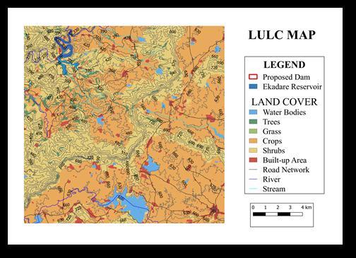
Fig 4: LULCMap.
Someofthebasicrequirementsforcanalalignmentwereasfollows:
1 Thecanalalignmentswerechoseninsuchawaythatwaterflowedprimarilythroughgravity,withaslittlepumpingas feasible
2 Landuselandcovermapswereusedtoidentifyandavoidbuiltupregions
3 Thealignmentsprovidedrunthroughthemostoftheopenlandpossible
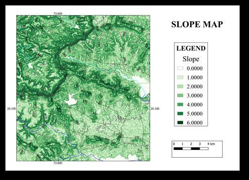
4 Themajorityofthetime,roadandrivernetworkswereavoidedsothatcrossdrainageworkwouldbeminimal Thefourcanalalignmentsareinvestigatedbasedongeology,hydrology,andlanduse,withthemostsuitablealignmentchosen basedontopographiccircumstancesandmeetingthecanalalignmentcriteria Figure2showscontourmap,slopemapandLULCmapthatareusedforpassingthealignments
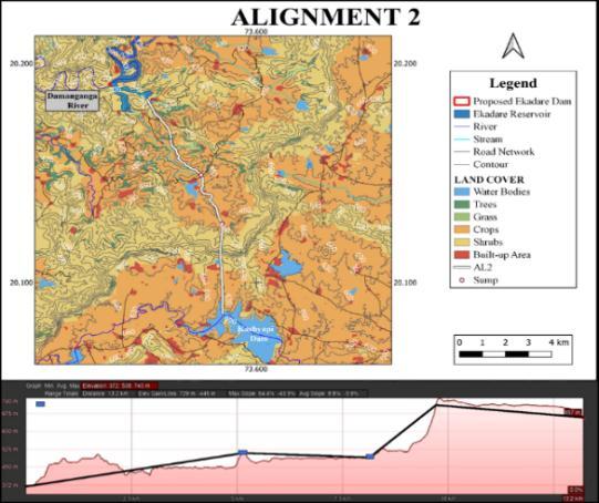
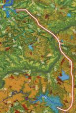
Between Ekadare Dam and Kashyapi Dam, a canal alignment was suggested The canal runs from the proposed Ekadare Reservoir'sleftbanktoasumpatRD47km,FSL550m,andaliftof170m ThenitflowsuptoRD67kmbygravity Thelink thentakesofffromthesumpatFSL540m,pumpingthroughapipelinetoasumpatRD79km,FSL715m,withaliftof175m ThecanalrunsfromasumpatRD79kmthroughatunneltoRD127kmontheupperbankofKashyapiReservoir,withanFSL of715m Inthetunnel,waterflowsduetogravity Thecanalis127kmlongintotal Thetotalliftingheadis345m Shingdari, Cholmukh,Kulwandi,ShivajiNagar,HoldarNagar,andKashyapnagarareamongthevillagesservedbythelink Itcrossesa majorroadatadistanceof358km,necessitatingtheconstructionofanoverbridge Onlyonecrossdrainageworkisrequired inthiscase Thisalignmenthastheshortestlengthofthefourproposedalignments Figure5showscanalalignment1
International Research Journal of Engineering and Technology (IRJET) e ISSN: 2395 0056
Volume: 09 Issue: 07 | July 2022 www.irjet.net p ISSN: 2395 0072
Fig 5: Alignment1
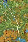
ThealignmentrunsfromtheproposedEkadareReservoir'slowerrightbanktoasumpatRD515kmatFSL510mwithaliftof 140m ThenitflowsuptoRD815kmduetogravity ThelinkthentakesofffromthesumpatFSL490mbypumpingthrougha pipelinetoasumpatRD97kmatFSL700mwithaliftof210m ThecanalstartswithanFSLof700mfromasumpatRD97 kmandcontinuesthroughatunneltoRD132kmontheupperbankofKashyapiReservoir Inthetunnel,waterflowsdueto gravity Thecanalis132kilometreslongintotal Atotalof350mofliftingheadisavailable Ruipetha,Murmuti,Fanaspada, Pate,Donwade,Umbardahad,Vaishnavnagar,andIndiranagararethevillagescoveredbythislink Itcrossesfiveroadsat distancesof116kilometres,524kilometres,594kilometres,782kilometres,and107kilometres,respectively,andthusover bridgesmustbeprovidedatthosepoints Atachainageof543kilometres,itcrossesastream,necessitatingcrossdrainage work Itisthesecondshortestofthefouralignments Incomparisontootheralignments,itnecessitatesmorecrossdrainages Figure6showscanalalignment2
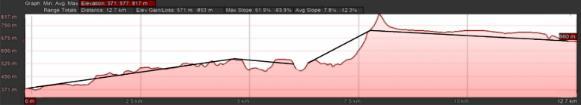
Fig 6: Alignment2
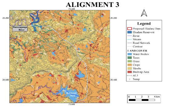
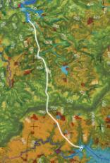
ThealignmentrunsfromtheproposedEkadareReservoir'slowerrightbanktoasumpatRD26km,FSL404m,witha34m lift ThelinkthenstartspumpingtoasumpatRD48km,whichisatFSL486metres It'san82meterlift Thelinkthenascends throughapipelinefromsumpatRD48kmtoasumpatRD61kmatFSL681m,withaliftof195m Thecanal,thenrunswith anFSLof681mfromasumpatRD61kmtoRD92kmthroughtunnel Inthetunnel,thewaterflowsbygravity Thecanal thentakesofffromRD92kmatFSL673mtoRD186kmatFSL635mthroughgravity Thecanalis186kilometreslongin
2022, IRJET | Impact Factor value: 7.529 | ISO 9001:2008 Certified Journal |
International Research Journal of Engineering and Technology (IRJET) e ISSN: 2395 0056
Volume: 09 Issue: 07 | July 2022 www.irjet.net p ISSN: 2395 0072
total The total liftingheadis311 m Thus at threepoints,pumpingis required Dolharmal,Kohor, Ladachi,Sadgaon,and Dhondegaonarethevillagescoveredbythislink Itcrosseseightroadsatdistancesof16km,33km,46km,948km,125km, 1386km,1445km,1537km,and179km,respectively,andthusoverbridgesmustbeprovidedatthosepoints Itcrossesthe streamatadistanceof24km,necessitatingcrossdrainagework Thusatninedifferentlocations,crossdrainageworkis required Figure7showscanalalignment3
Fig 7: Alignment3

ThealignmentrunsfromtheproposedEkadareReservoir'slowerrightbanktoasumpatRD42kmatFSL515mwithaliftof 145m ThenitflowsuptoRD102kmduetogravity ThelinkthentakesofffromthesumpatFSL505m,pumpingthrougha pipelinetoasumpatRD119km,FSL720m,withaliftof215m ThecanalrunsfromasumpatRD119kmthroughatunnel toRD152kmontheupperbankofKashyapiReservoir,withanFSLof720metresto660m,respectively Inthetunnel,water flowsduetogravity Thecanalis152kmlongintotal Thetotalliftingheadlengthis360m Dolharma,Ruipetha,Fanaspada, Pate,Donwade,Vaishnavnagar,andIndiranagararethevillagescoveredbythislink Itcrossessixroadsatdistancesof17km, 35km,532km,779km,914km,and1282km,respectively,andthusoverbridgesmustbeprovidedatthosepoints The amountofarablelandcoveredisgreaterbuttherequirementofcrossdrainageworkismore Figure8showscanalalignment4
Fig 8: Alignment 4
2022, IRJET | Impact Factor value: 7.529 | ISO 9001:2008 Certified Journal
International Research Journal of Engineering and Technology (IRJET) e ISSN: 2395 0056
Volume: 09 Issue: 07 | July 2022 www.irjet.net p ISSN: 2395 0072
• Shortestlink
• Onlyonecrossdrainageworkisrequired
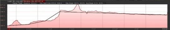
1 127km
• Coverssignificantcultivablearea
• Twostagepumpingisrequiredwithtotalliftof345m
• TotalGravityflow 68km (53%)
• TunnelLength 48km
•
2 132km
Secondshortestlink
• Crossdrainageworkisrequiredatsixlocations
• Coversmorecultivablearea
• Twostagepumpingisrequiredwithtotalliftof350m
• TotalGravityflow 65km(49%)
• TunnelLength 35km 3 186km
• Longestlink
• Crossdrainageworkisrequiredatninelocations
• Threestagepumpingisrequiredwithtotalliftof311m
• TotalGravityflow 125km (67%)
• TunnelLength 31km 4 152km
• Crossdrainageworkisrequiredatsixlocations
• Coversmorecultivablearea
• Twostagepumpingisrequiredwithtotalliftof360m
• TotalGravityflow 95km(625%)
• TunnelLength 33km
Acomparisonofallfouralignmentsisshowninthetable Itshowsthelengthofthealignments,thenumberofcrossdrainage worksnecessary,theamountofpumpingrequired,totalgravityflow,andtunnellength Alignment1istheshortestwhereas alignment3isthelongest
Theanalysisofmapssuchasslopemaps,contourmaps,landuselandcovermapsoftheareabetweentheproposedEkadare damandtheKashyapidamledtotheselectionofasuitableinterlinkingcanaltocarrysurpluswaterfromtheEkadaredamto the Kashyapi dam Based on the GIS study, various alternative proposals were considered, taking into account length, suitability,pumping,andlanduserequirements Civilengineeringstructuressuchasroads,bridges,andotherstructureswere takenintoaccountwhenchoosingcanalalignmentstreams Thealignment1hasbeenchosenasthemostsuitablebasedonthe tabulateddatainresulttable,asitistheshortestlink (127km) andhasthelowestCDworkswithtwostagepumpinganda totalliftof345m
International Research Journal of Engineering and Technology (IRJET) e ISSN: 2395 0056
a) TheprojectcanbeusedasabaseforcostestimationwhichwillincludethecostofDamconstruction,Canalconstruction, PumpingStationandsumpconstruction,CostofCutting&FillingofEarthwork,CostofPumping Theresultsmayvary dependingonthecostanalysisandcostbenefitratio,andthechosenalignmentcanbechanged
b) DesignofTunnel, c) DesignofCanal, d) DesignofPipeline.
[1] AnupriyaandChamatL2018StudyofinterlinkingofriversbyusingGeographicInformationSystem (GIS) withQUANTUM GIS IJERT vol 7 issue03
[2] PatelA,SinghNandPrakashI2015Planningofriverinter linkingcanalsystembetweenShetrunjiriverandDhatarwadi river,Saurashtra,India,usingremotesensingandGIS IJSTE vol 1 issue11
[3] KanjaniH,MotianiA,PrakashIandMehmoodK2016SelectionofinterlinkingcanalalignmentfromKadanaDamto WatrakDam,Gujarat,usingremotesensingandGIS IJSTE vol 2 issue11
[4] KrishnaveniM,PrakashvelJ,KaarmegamM2003GISandVisualisationCapabilitiesforInterlinkingofIndianRivers
[5] IntegratedStateWaterPlanforGodavariBasininMaharashtraVolume1: IntegratedPlan2017
[6] IntegratedStateWaterPlanforWestFlowingRiverBasininMaharashtraVolumeII: IntegratedPlan2018
Volume: 09 Issue: 07 | July 2022 www.irjet.net p ISSN: 2395 0072 © 2022, IRJET | Impact Factor value: 7.529 | ISO 9001:2008 Certified Journal