International Research Journal of Engineering and Technology (IRJET) e ISSN: 2395 0056

Volume: 09 Issue: 07 | July 2022 www.irjet.net p ISSN: 2395 0072
International Research Journal of Engineering and Technology (IRJET) e ISSN: 2395 0056
Volume: 09 Issue: 07 | July 2022 www.irjet.net p ISSN: 2395 0072
2,3,4
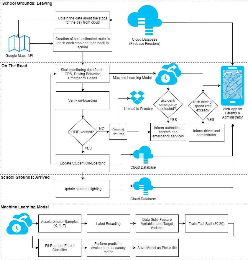
Thousandsofstudentsuseschooltransportationaround the world. We require a transportation system that is effective,reliable,safe,and smart.Thesuggestedsystem depicts a transportation concept that provides real time tracking, calculates optimal routes to destinations, detects intrusion, and assists in the maintenance of transportation system statistical data. IR sensors and RFID tags are used to create an IoT network. The detection of intrusion is done via facial recognition. Google Maps, GPS, and accelerometer data are used to detect live location. A bus mounted Raspberry Pi microcontroller interfaces with a centralised Firebase cloud platform. Admins and parents can access the mapped data via a mobile application. The system saves important data such as driving abilities, attendance analysis,andtheoptimalroutes.IntheMLoptimizer,the dataiseffectivelyused.
Key Words: IoT, IR sensor, RFID, Raspberry Pi, GPS, Cloud,GoogleMaps,ML
Forparents,gettingtheirchildrentoandfromschoolisa major problem. Several concerns arise, including extended waits for delayed buses, kidnapping, and kids deboardingatincorrectstations.Otherconcernsinclude a lack of knowledge regarding the routes used by the school bus to reach its destinations, as well as stopping unauthorisedindividualsfromaccessingthebus.Student safety has long been a top priority, especially for working parents, whose solutions must be continually enhanced [1]. Drivers may not be able to identify all students on time if one goes missing. Children are frequently prohibited from using cell phones on school grounds. It is difficult for school officials to contact each parent about their child's safety. [2]. If the motorist is involved in rash driving, the driver should be assisted and the caretakers should be informed [3]. By tracking andmonitoringstudents,theInternetofThingsprovides amuchbetterapproachforensuringtheirsafety.
***
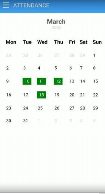
IoTisimplantedastheprimaryconcepttosolve andovercomethesechallenges. Web based bus tracking is provided by the proposed solution. Students entering the bus aredetected by an IR sensoratthe entry, which isverifiedbyanRFIDreader.TheRFIDdeviceisscanned for identification and information retrieval. When studentsboardthebus,theymustweartheiruniquetag to be scanned by the RFID scanner. Parents and administrators are notified when their child boards the bus using confirmed scanning. The Raspberry Pi microcontroller is used to update attendance over Firebase. If a scan mismatch occurs, a Firebase notice is issued to detect an intruder and capture the intruder's photo. When boarding or disembarking from the bus, eachchildisidentified.
The accelerometer keeps track of the bus's condition and analyses how it drives. In real time, the technology monitors the child's location and bus route. ThecarisfollowedbytheGPSmodule.TheGPSposition, driver behaviour, and emergency conditions are used to monitor the overall system. Caretakers would be contacted right away if an accident or emergency occurred. All preceding sections would be saved in Firebaseforfutureuse.
F Judy et al. [4] proposed a school bus monitoring system that uses RFID and GPS to communicate to a remote server using Wi Fi and an ESP8266 microcontroller. Caretakers could access information utilising the cloud based Firebase messaging service. Jisha et al. [5] developed a car monitoringsystemforschoolchildrenthatemployedGPS and GPRS/GSM technology to ensure the safety of the students. The system comprised of an Internet enabled androidapplicationthatcommunicatedwithaserver.
W. Pattanusorn et al. [6] devised a system that automatically registered children's information at the entry level when they passed through the scanner. SMS alertedparentsoftheirchildren'sschoolbusarrivaland departure times. H Eren et al. [7] proposed a sensory baseddrivingbehaviouranalysistechnique.Thetracking
International Research Journal of Engineering and Technology (IRJET) e ISSN: 2395 0056 Volume: 09 Issue: 07 | July 2022 www.irjet.net p ISSN: 2395 0072
was done using a smartphone to simulate a car independent system without the need for vehicle mounted sensors. Muneer et al. proposed an android based framework that combined GPS data with Google maps data to accurately locate the misplaced mobile phone.[8]
The need for the development of a real time transportation based information system for users, which might aid in improved trip planning and reduce bus waiting time, sparked interest. Real time data processing can help commuters get at their destination fasterbyreducingwaitingtime.
The proposed work uses IoT with RFID, RaspberryPi,IR sensor,GPS,Firebase, andGoogleMaps toachievefeaturessuchasattendanceanalysis,notifying end users with alighting and boarding alerts, location tracking through GPS by integrating Google Maps, intrusion and accident detection, and cloud storage to expand the security framework and traceability aspects of the child. The mobile application would make this information available to the administrator, parents, and driver.
The proposed system utilizes the following hardwareandsoftwarecomponents:
The bus's hardware is the most crucial component. The hardware utilised for prototype development is described in this section, which comprisesthefollowing:
The primary function of an IR Sensor is to measure and detect infrared radiation in the surrounding environment.Theproposed systemusesanIR sensoras thefirststepinverifyingthestudent'sentryintothebus. With a pair of infrared transmitters and a receiver tube, an IR Sensor module has an adaptable potentiality of atmospheric light. Infrared technology is used in a varietyofwirelessapplications.
The RFID RC522 Card Reader Module, based on the MFRC522 controller, is a low cost 13.56 MHz RFID reader module. The module necessitates a 3.3V power supply.Itcancommunicate withanyCPU board directly using the SPI protocol, and it also supports I2C and UART. It is utilised for attendance analysis and person identificationintheproposedsystem.
The Raspberry Pi foundation microcomputer that was created to promote programming and computing principles. It has a 64 bit quad core processor with a clockspeedof1.4GHzanddual band2.4GHz.Ithas5GHz wireless LAN and Bluetooth connectivity, making it an ideal alternative for highly networked designs. Its high processing power and on board connectivity make it idealforIoTapplications.
The 5 megapixel Camera Module Rev 1.3 is a specially developedRaspberryPiadd on.AuniqueCSIinterfaceis utilised for camera interaction. The CSI bus provides extremely high data speeds and consistently transports pixeldata.Itisusedtocaptureasnapshotoftheintruder intheproposedsystem.
TheNeo 6MGPSmoduleisareliableGPSreceiverwitha 25 x 25 x 4mm ceramic antenna built in. It has a good satellitesearchcapacity.Thepowerandsignalindicators canbeusedtocheckonthemodule'sstatus.Itisusedto gatherinformationaboutgeographicalparameters.
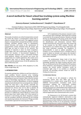
The MPU6050 is a single chip 3 axis accelerometer and gyroscope.Itisalsoknownasasix axismotiontracking or six Degrees of Freedom (DoF) device because of the three accelerometer and three gyroscope outputs. Hardware components used in the prototype developmentareshowninFigure1.
HTML,JS,CSS,jQuery,andBootstrapwereusedtocreate the android application. In order to view the current location, the Google Maps API has been integrated into the programme. Using Firebase fire store, we were able to get real time changes. Apache Cordova was used to encapsulatethisviewinanapp.
International Research Journal of Engineering and Technology (IRJET) e ISSN: 2395 0056
Volume: 09 Issue: 07 | July 2022 www.irjet.net p ISSN: 2395 0072
The Firebase database is a cloud based database that allows for real time data syncing and storage across users around the world. It promotes user participation and serverless application development. JSON is the format in which the NoSQL database is stored. When developing cross platform programmes, a Realtime Database instance can be shared among all clients. Even iftheappgoesdown,thedataisstillaccessible.
Google has created application programming interfaces (APIs) that allow users to communicate with Google Services and integrate them with other services. Analytics, machine learning as a service, and user data access are among the features. Google Maps can also be integrated into a website or application. It is possible to provide users with relevant content and to customise their map view according to the site. It is used in the suggested model to add a map to the Android app to detectbusroutesanddeliverthebestwaytodestination withreal timetrafficupdates.
Hardwarecomponents,APIs,andotherwebservicesare used to collaborate. Node RED is a popular visual programming tool that comes with a web based editor. JSON canbeusedtosavetheflowsandsharethemwith others. They can be used at any moment with a simple click. It is an event driven and non blocking approach that is based on Node.js. The Raspberry Pi is being used inthecurrentsystem.
Bootstrapisawebapplicationframework.Consistencyis maintained across browsers and device screen sizes thankstoHTMLandCSS.Ithasalargenumberofplugins and themes. Because jQuery is an open source tool, it is used to create client side scripting on HTML, which makeswebsitesmoreresponsive.
Apache Cordova is a mobile development framework thatisfreeandopen source.BycombiningHTML5,CSS3, and JavaScript, we can create hybrid web applications. It's in charge of bridging the gap between web based apps and native mobile capabilities. It serves as a link betweenwebappsandmobiledevices.
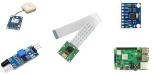
Thesuggestedsystemseekstoprovideeffectiveservices through the integration of various technologies and the InternetofThings.Thesuggestedsystem'sdiagrammatic representationisshowninFigure2.
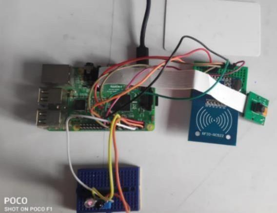
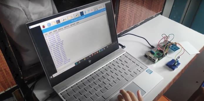
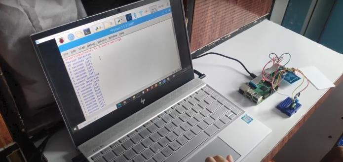
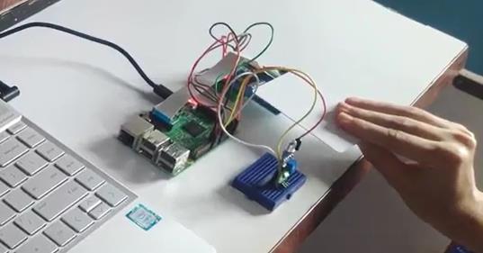
In Figure 3, you can see a hardware prototype of the system.Itemphasisesthevariouscomponentsthatwere usedtoconstructtheprototype.TheRaspberryPiserves as the system's brain, connecting to several sensors like as GPS, Accelerometer, RFID, IR, and Camera. For database management, it's also linked to Google Firebase. The Raspberry Pi and the Firebase have most ofthedatainsync.
The administrative, driver, and parent mobile apps are designed to keep everyone up to date on the latest information,suchasroutes, livemonitoring,attendance, andnotifications.
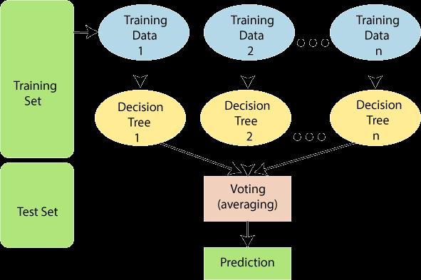
The accident detection method is based on the Random Forest Machine Learning Classifier (Fig. 4). Random Forest is a popular machine learning algorithm that belongs to the supervised learning technique. This algorithm solves classification and regression problems in machine learning. It is based on the notion of ensemble learning, which entails merging numerous
International Research Journal of Engineering and Technology (IRJET) e ISSN: 2395 0056
Volume: 09 Issue: 07 | July 2022 www.irjet.net p ISSN: 2395 0072
classifiers to solve a complex problem and improve the model'sperformance.
Following successful verification, the tag data is transferred to the cloud via a Raspberry Pi microcontroller, where it can be accessed by admins, parents, and drivers via a mobile application. This aids parents and school officials in collecting attendance reports. If an RFID reader is not discovered, the camera is used to identify a suspected breach. At that point, a photographofthepersonistaken.
Throughout the journey, data from the accelerometer andGPSmoduleiscollectedandsenttothecloud.
"Random Forest is a classifier that contains numerous decisiontreesonvarioussubsetsofa givendatasetand takes the average to increase the predicted accuracy of thatdata set,"asthenamesuggests.Ratherthan relying on a single decision tree with a majority of votes, the random forest classifier collects predictions from all treestoforecastthefinalresult. Thegreaterthenumber oftreesintheforest,thehighertheaccuracyandtheless likelyitistooverfit.
The Random Forest algorithm, as shown in Figure 4, works in two phases: first, it creates a random forest by mixing N decision trees, and then it makes predictions foreachtreeformedinthefirstphase.
The steps and diagram below show how the working processworks:
Step1:PickingKdatapointsatrandomfromthetraining set.
Step 2: Create decision trees for the data points you've chosen(Subsets).
Step 3: Determine the number of decision trees to be constructed(N).
Steps4:steps1&2arerepeated.
Step 5: Find the forecasts of each decision tree for new data points, and assign the new data points to the categorywiththemostvotes.
InSection4,Fig 8 depicts theimplementedarchitecture algorithm that outlines the entire flow. It emphasizes how the various elements (hardware and software) interact with one another. Students enter the bus through an IR sensor, which is verified by an RFID reader.
Thephysicalcoordinatesofthevehicle'slocationaswell asthespeedcanbetrackedusingGPS basedinformation combined with Google maps data. Machine Learning information from the driving behaviour analysis is used to detect accidents, assuring student safety. In the event of an emergency, the administration can contact the driver.
This phase of the pilot study develops the findings and conclusions. The bus route has three stops in the design execution. The data was retrieved for two months (February and March 2020). The traffic pattern, driving behaviour, and identification of possible bottlenecks in that route are among the conclusions drawnfromthestudyandtesting.Datafortheproposed system was gathered using GPS units installed in school buses.
The 3.6 kilometer experimental route was chosen from Vidyalankar Institute of Technology in Mumbai to Matunga Railway Station in Mumbai. On this route, there are nine bus stops. GPS data from the devices installed in the buses was relayed to a server every 60 seconds. Latitude, longitude, speed, and time stampswereallincludedintheGPSdata.
Thedatareceivedintheserverwasimmediately processedinordertomakea real timepredictionofthe bus'sarrivaltime.Thetimeofarrivalofthenextbusstop was predicted using data from previous days and real time data from a GPS receiver at the current bus stop. The mobile app enabled for attendance tracking as well as real bus location tracking, as well as warnings (for intrusiondetectionandaccidentdetection). Theoutputs for RFID scanning, student detection, and intrusion detectionaredepictedinFigures 5,6and7.
International Research Journal of Engineering and Technology (IRJET) e ISSN: 2395 0056
International Research Journal of Engineering and Technology (IRJET) e-ISSN: 2395-0056
Volume: 09 Issue: 07 | July 2022 www.irjet.net p-ISSN: 2395-0072
International Research Journal of Engineering and Technology (IRJET) e-ISSN: 2395-0056
Volume: 09 Issue: 07 | July 2022 www.irjet.net p-ISSN: 2395-0072
The implementation algorithm has been broken into threecomponents,asshowninFig 8,tomakeiteasierto understand.Thedataaboutthestopsandbest estimated routes is examined and stored on the cloud database startingat the top. RFIDissetup to detectstudentsand intruders. The image of the invader is captured, saved, and sent to the cloud. Using a Machine Learning model, an accelerometer is utilised to calculate and evaluate drivingbehaviourforaccidentdetection.
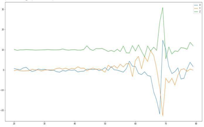
Figure 9 depicts various views of the proposed implementation of the mobile application. The graphs below exhibit accelerometer data for accident detection for several samples (X Axis Timeline & Y Axis G Values). The samples were gathered in order to better understandhowpeoplebehaveinvarioussituations.The data was then entered into the ML model to make predictions after it had been wrangled. A 91.8 percent accuracyratewasobtained.
Fig 11: Accident detection and Attendance view
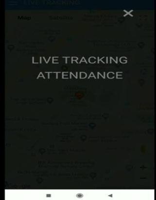
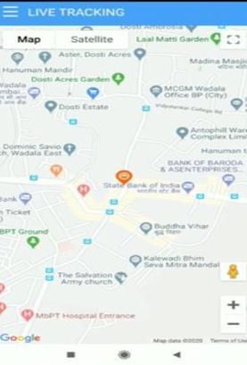
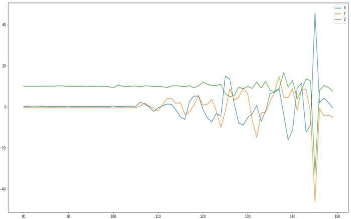
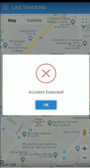
Fig-12a: Sample Data 1

Fig 12b: Sample Data 2
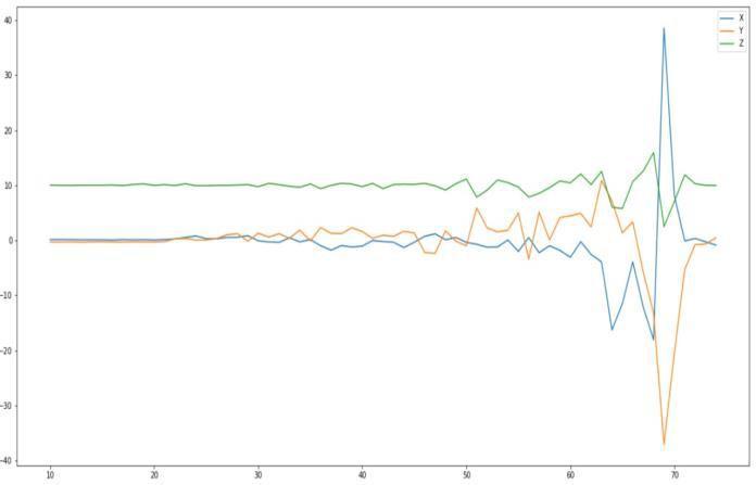
Fig 10: Live Tracking Tabs
International Research Journal of Engineering and Technology (IRJET) e-ISSN: 2395-0056
Volume: 09 Issue: 07 | July 2022 www.irjet.net p-ISSN: 2395-0072
[6] W. Pattanusorn and I. Nilkhamhang, “Real Time Monitoring System for University Buses using Available Wi Fi Networks and Travel Time Prediction,” 2018 15th International Conference on Electrical Engineering/Electronics, Computer, TelecommunicationsandInformationTechnology.
[7] H. Eren, S. Makinist, E. Akin, and A. Yilmaz, “2012 Intelligent Vehicles Symposium Alcalá de Henares, Spain,June3 7,2012.
Fig-12c: Sample Data 3
The prototype was successfully implemented, and the key functionalities of student detection via RFID, intrusion detection, location tracking, and accident detection were all confirmed to be correct. Secondary capabilitiessuchasattendanceanalysis,routeestimates, cloud storage of essential data, and custom alerts were also tested and found to work as expected. The prototypeoutperformsGSMandArduino basedsystems by combining GPS and Google Maps APIs to give live location and real time tracking of children Overall, this was a positive step toward a brighter future for Smart Schoolbuses.
[1] R. Bandal and A. Oak, “Managing Location IdentificationandChainSMSforSmartSchoolTransport System using IoT,” IEEE 2019 International Conference on Computer Communication and Informatics (ICCCI 2019),Jan.23 252019,Coimbatore,INDIA.
[2] B. Pavithra, S. Suchitra, P. Subbalakshmi, J. Mercy Faustina, “RFID based Smart Automatic Vehicle Management System for Healthcare Applications,” Third International Conference on Electronics Communication andAerospaceTechnology[ICECA2019].
[3] N. Akhtar, K. Pandey, S.Gupta, “Mobile Application For Safe Driving,” 2014 Fourth International Conference onCommunicationSystemsandNetworkTechnologies.
[4] J. T. Raj, J. Sankar, “IoT Based Smart School Bus Monitoring and Notification System,” 2017 IEEE Region 10HumanitarianTechnologyConference(R10 HTC)21 23Dec2017,Dhaka,Bangladesh.
[5] Jisha R C et al., “An Android Application for School Bus Tracking and Student Monitoring System,” 2018 IEEE International Conference on Computational IntelligenceandComputingResearch.
[8] M. Ahmad Dar and J. Parvez, “A Live Tracking Framework for Smartphones,” IEEE Sponsored 2nd International Conference on Innovations in Information EmbeddedandCommunicationSystemsICIIECS’15.