International Research Journal of Engineering and Technology (IRJET) e ISSN: 2395 0056

Volume: 09 Issue: 07 | July 2022 www.irjet.net p ISSN: 2395 0072
International Research Journal of Engineering and Technology (IRJET) e ISSN: 2395 0056
Volume: 09 Issue: 07 | July 2022 www.irjet.net p ISSN: 2395 0072
1Associate Professor, Dept. of ECE, Global Academy of Technology, Karnataka, India 2,3,4Student, Dept. of ECE, Global Academy of Technology, Karnataka, India ***
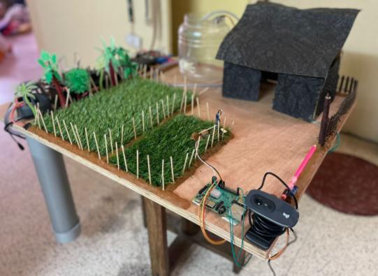
Abstract - Smart Farming is an emerging concept that uses modern technology to improve the quality of farming. IoT Sensors give sufficient information regarding the farm fields and allow farmers to take immediate precautions. This paper mainly focuses on developing a system that can monitor livestock, measure the level of water and the moisture content in the soil. It also uses a face recognition system in order to have increased security in the farm. A model is created to have an implementation of all the above applications in the smart farming system. For developing this system, we make use of Raspberry Pi and Arduino UNO. Compiling data gathered from the sensors and electronic devices, It becomes easier for a farmer to keep track of the fields in an efficient way. In order to provide a good user interface, we have also developed a software application for the farm through which, the smart farming system can be operated from any part of the world with the help of technology which can be a breakthrough.
Key Words: Smart Farming, Raspberry Pi, Sensors, Arduino UNO, Haarcascade, Android Studio.
Farming plays an important role for the survival of the wholeworld.Basicneedsforthesurvivalofahumanbeing are provided by farming. Traditional farming methodologies are replaced by modern technology. Now, weareinastagewheretechnologyisimprovinginvarious domains. In the current scenario, Farmers face lots of difficulties in order to monitor the livestock, For proper water management in the farm where the water level has to be detected constantly not leading to resource waste, for measuring volumetric moisture content in the soil in order to decide on the crops to be grown, To detect who entersthefarmforcontrollingtheft inthefarm. Keeping these adversities in mind, we have developed a model for the smart farming system which includes a Livestock monitoringsystemwhereGPSisusedtotrackthelocation of the livestock through latitudes and longitudes fetched by the satellite, a water level monitoring system which gives us the amount of water present in the tank and wheneverthewatergoesbelowaspecifiedlevel,itwillbe pumped from the pond to the water tank, A soil moisture sensor having electric resistance property is used to determinethemoisturecontentinthesoil,Toenhancethe security in the farm a face recognition system is used to
openthegatesofthefarmonlyfortheauthorizedpeople. A software application has also been created to get real timeupdatesofalltheactivitieshappeninginthefarm.
TheIndianfarmingsegmentisinacriticalstagebecauseof advancements in the fields of technology and automation. Lands completely rely on rains and borewells for irrigation purposes. India is one of the top irrigated countriesinthewholeworld,yetonly33%ofthecropped area isused for irrigation. Also,real time animal tracking, unfixed soil conditions, location tracking and maintaining the security of the farm will be the major issues faced by farmers.Toprovideanefficientsystemthathelpsfarmers to make better decisions , we use WSN, which handles different activities like cattle tracking, soil moisture detection,waterlevelmonitoring,andFacerecognitionfor security.Anyinformationrelatedtothefarmthatisuseful to the farmer, will be provided to the farmer. This digital transformation is changing the farm management at a rapidpace.
Theobjectivesofthisstudyisto:
● Track the location of cattle using a GPS module andtheInternetofThings.
● Measure water level precisely using Ultrasonic sensorsandtheInternetofThings.
● Ensure security in the farm by implementing a FacerecognitionsystemusingMachineLearning.
● Detects the surrounding temperature, moisture contentofthesoil.
● Develop an interface between the model and farmer by creating an application for easy access toeverything.
● CreateamodelofSmartFarming.
International Research Journal of Engineering and Technology (IRJET) e ISSN: 2395 0056
Volume: 09 Issue: 07 | July 2022 www.irjet.net p ISSN: 2395 0072
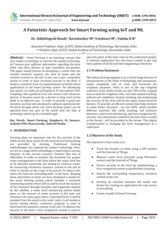
Fig 1:BlockDiagram
Raspberry Pi 3B+: Raspberry Pi 3B+ is a single board computer which runs in an open source ecosystem. It has 40 pins out of which 26 are GPIO pins. It has a ARM Cortex A53 CPU Broadcom processor working at 1.4GHz. It supports the use of wireless LAN and Bluetooth. It also offers a faster Ethernet and has improved thermal management. They are widely used for various applications such as weather monitoring, home automationandsecurity.
Arduino UNO: It isanopen sourcemicrocontrollerboard which works on the basis of the Microchip ATmega328P having an operating voltage of 5V. The Input Voltage rangesfrom7 20VandClockSpeedcangoupto16MHz. Theboardconsistsof6analogand14digital I/Opinsthat can be easily integrated with other circuits. It can be programmedusingArduinoIDEwiththehelpofUSBcable of type B. In order to support the Arduino it consists of different components like crystal oscillator, voltage regulator,serialcommunicationetc.
Thepurposeofusingthismicrocontrollerhereis becauseofitsaddedadvantageofhavinganin builtADC converterwhichisrequiredforsoilmoisturesensor.
1. Collection of Sensor Data Information from the farmunderstudy.
2. Uploading of Sensor Data Information into the cloud.
3. Accessing this information using Mobile ApplicationandalertnotificationusingIFTTT.
A sensor is a device that creates an output signal in order to sense the physical phenomenon. The different sensorsusedhereare:
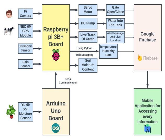
YL 69 Soil Moisture Sensor: It is used to measure the percentage of moisture in the soil and this particular sensorhasanoperatingvoltageintherangeof3.3 5V.Itis ideally used to construct an automatic system for measuring the moisture content and watering of the plants.
Having 4 pins and made up of two electrodes it works on the principle of Electrical resistance. When a current flows through these electrodes, the resistance to the current in the soil determines the amount of moisture present. If more current passes through the electrodes it impliesthatthesoilhasmorewater.
The output of this sensor is given in percentage and based on the crop we can set the threshold value to determinethemoisturecontent.
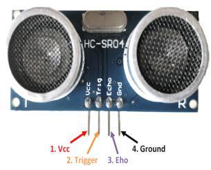
HC SR 04 Ultrasonic Sensor: It is a sensor that helps to compute the distance through ultrasound when it travels intheair.Asoundwaveissentbythetransmitterandthis waveispickedupbytheobjectandisreflectedbacktothe sensor.This particular sensor operates by transmitting a sound wave work by sending a sound wave(Ultrasonic Sound).Theydeterminethedistancetoaobjectbyfinding the time lapse between the transmitted and received ultrasonic pulse. It requires a DC power supply of 5V and themeasuringangleis15degrees.
Theoutputofthissensorisgiveninpercentage.It is used to find the percentage of water present in the overhead tank. If the level of water drops below the set threshold,waterispumpedintothetankusingaDCpump.
International Research Journal of Engineering and Technology (IRJET) e ISSN: 2395 0056
Volume: 09 Issue: 07 | July 2022 www.irjet.net p ISSN: 2395 0072
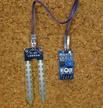
Servo motor: It works on the principle of PWM ie. Pulse Width Modulation. The angle of rotation depends on the duration of the applied pulse to the control pin. It mainly consists of a DC motor and they are compact and have high output power. They can rotate approximately 90 degrees in each direction. They operate at a speed of 0.1 s/60degreeandvoltageof4.8Vto5V.
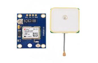
Neo 6M GPS Module: In order to locate all the locations onEarthwithagoodlevelofapproximationaGPSmodule known as NEO 6M GPS module is used. This consists of a GPS chip which can track upto 22 satellites and it also requires an antenna which is connected through a U.FL connector. It consists of four pins namely TX,RX, VCC and GND.Ithadanoperatingvoltageof3.3 to5.5V.Thedatait gets from these satellites will be in NMEA data format which is a standard format supported by most GPS manufacturers.
By using python, the latitude and longitude values can be parsed and used to create a google map link to locate the livestock.
The purpose of this motor is for opening/closing of the gates by allowing only authorized persons to enter intothefarmwhichisdoneusingFaceRecognition.
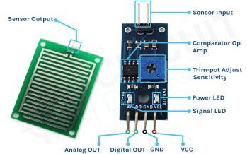
Rain Sensor: Arainsensorisusedtodetecttherainfall.It acts like a switch and works under the principle that the switch will be closed when there is rain detected. Basically, this board is made up of Nickel coated lines. An operational amplifier is used to calculate the resistance, a parallel resistance that will be created when rain falls on thesensor.
The purpose of the sensor here is to make sure thatthepumpisworkingproperlyandthereis noair lock inthepipe.
Python Web Scraping: The process of parsing and collecting the raw data from the web is called web scraping.Thereare3mainstepsin webscraping.Request module, Making a request and response object. Request libraryisusedtomakearequesttoaspecificURL.
Python request module makes use of its built system in order to send HTTP requests to a specific URL using POST,PATCH,HEAD,GET or PUT requests. When a request is made to a URL a response is returned. The responseobjectismadeofseveralattributesandfunctions thathelpsinnormalizingthedata.
The purpose of this in the project is to inform the farmerabouttheweatherconditionsofhisrespectivearea inreal time.
Haar Cascade Classifier algorithm: It is a machine learning algorithm used for object detection which is proposed by Viola and Jones which helps in identifying faces.Inreal timevideoit givesa huge numberof positive images as faces and the rest as negative images.The algorithm is light ,simple and works in real time with a perfectframepersecond.
There are different models stored as XML files in therepositoriesthatcanbereadwithOpenCVmethods.In our project we are using haarcascade_frontalface_default.xml file for training the model.
International Research Journal of Engineering and Technology (IRJET) e ISSN: 2395 0056
Volume: 09 Issue: 07 | July 2022 www.irjet.net p ISSN: 2395 0072
The data gathered from the sensors will be uploaded to the cloud using api keys and here we make use of google firebase.
In order to create mobile and web applications, Google developed a special platform and named it as Firebase. It was an independent company that was established in 2011. This is a Google backed app developmentsoftwarethat hasallowedall thedevelopers to develop web, iOS and android apps. Not only will it provide tools for tracking analytics, fixing and reporting theappcrashes,Itprovidesaswiftmethodinkeepingthe gathered sensor data at the device level. It can also work withAndroidAPIssupportedbyAndroidThings.
For a farmer to access everything in a single tap an app hasbeendevelopedbyusingAndroidStudio.
Android Studio, popularly known as an IDE for android applicationdevelopmentisfrequentlyused,asitprovides more features that add to productivity in building the androidapplications.Ithasaworkablebuiltinsystemthat is gradle based and an emulator for application testing and verification that is fast and has a wide variety of features.Itusesanintegrated environment wherewecan make changes to the code behind a running application withoutevenhavingtorestarttheapplication.Itprovides large scaletestingtoolsand supportsC++.Androidstudio makesiteasiertointegratetheappengineandthegoogle cloud messaging as there is inbuilt support for google cloudplatform.
IFTTT: The abbreviation of IFTTT is If This, Then That. If the condition is satisfied in the application, then a certain actionisperformed.Avarietyoftaskssuchassendingtext messages can be performed using IFTTT when connected toRaspberryPi.
4. Real time moisture level monitoring and maintainingmoisturecontentintheplot.
5. Farmers get live updates of the surrounding temperature and humidity which help them to planahead.
1. Equipmentthatisbasedonsmartfarmingrequires a farmer to implement and understand the usage of technology and its advancements, which is a majorchallengeasittakestimeforallthefarmers toadapttothistechnology.
2. Itiscostlyandaonetimeinvestment.
1. If any one of the cattle goes out from a certain boundary,thelocationofthecattleandawarning message will be sent to the farmer regarding the same.
2. When the water level in the tank decreases, the water will automatically be pumped from the waterresourceinthefarm.
3. Only the authorized people will be able to enter the farm and will be able to govern all the activitiesthattakeplaceinthefarm.
4. A model is created to give a clear picture of all processesthattakeplaceinthefarm.
5. The farmer will be getting the real time updates and alerts of all the activities happening in his farm.
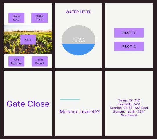
Fig 7: Applicationforaccessing informationaboutfarm
International Research Journal of Engineering and Technology (IRJET) e ISSN: 2395 0056
Volume: 09 Issue: 07 | July 2022 www.irjet.net p ISSN: 2395 0072
[4]. N. Dileep Kumar, S. Shanthi “Automatic Gate using Face Recognition Technique using HAAR Cascade Algorithm”, International Journal of Engineering and Advanced Technology (IJEAT), Volume 9 Issue 3 (Feb2020).
[5]. Sushanth & G. Sujatha “IoT Based Smart Agriculture”, International Conference on Wireless Communications,SignalProcessingandNetworking (WiSPNET) (Nov2018).
[6]. Dr.V. Vidya Devi & G. Meena Kumari “Real Time AutomationandMonitoring System forModernized Agriculture”, International Journal of Review and Research in Applied Sciences and Engineering (IJRRAS)Vol3No.1 (Mar2018).
Smart farming in the future is not just limited to basic principles, butis anidea for research,developmentinthe fields of automation and innovation. IoT can also handle issues relating to climatic changes, animal tracking and welfare,therebycontributingtoahealthywayoflivingfor all the consumers. These systems help to determine the quality of soil. Farmers are able to solve irrigation problems, temperature problems, humidity problems, etc. Theavailabilityofsensorsfortheagricultural parameters and microcontrollers can be easily interfaced with each other and with the help of Internet of Things challenges facedbythefarmerscanbebroughtdownandhelphimto have easy access to various information about his farm and also to automate certain operations. So, farmers are able to control various equipment related to agriculture andmonitortheircropsonsmartphonesoroncomputers.
[1]. AnandNayyarandEr.VikramPuriproposed“Smart farming: IoT based smart sensors agriculture stick forlivetemperatureandmoisturemonitoringusing Arduino, cloud computing & solar technology”, The International Conference on Communication and ComputingSystems(ICCCS 2016) (Nov2016).
[2]. Shweta A M, Dr V. Nagaveni proposed “Survey on Smart Agriculture Using IOT”, Journal of Computer Programming and Multimedia Volume 4 Issue 1 (Nov2018).
[3]. Mrs.T. Vineela, J. NagaHarini, Ch. Kiranmai, G. Harshitha, B. AdiLakshmi proposed “IoT Based AgricultureMonitoringandSmartIrrigationSystem UsingRaspberryPi”,International ResearchJournal of Engineering and Technology (IRJET) Volume: 05 Issue:01 (Jan2018).