International Research Journal of Engineering and Technology (IRJET) e ISSN: 2395 0056

Volume: 09 Issue: 07 | July 2022 www.irjet.net p ISSN: 2395 0072
International Research Journal of Engineering and Technology (IRJET) e ISSN: 2395 0056
Volume: 09 Issue: 07 | July 2022 www.irjet.net p ISSN: 2395 0072
1First Author: Post graduate Student, Faculty of Architecture, Dr. M G R Educational & Research Institute, Chennai, Tamil Nadu
2Second Author: Head of the Department, Faculty of Architecture, Dr. M.G.R Educational & Research Institute, Chennai, Tamil Nadu ***
Abstract - Construction Industry accounts to 13% of the global GDP. Indian construction industry may grow at 10.7% inFinancialYear2022aspergovernmentfinancialreport[1]. This growth is expected owing to the government’s increased focusoninfrastructureprojectsandsmartrecoveryofdemand expected for residential as well as commercial segments. And yet, for the last two decades, productivity growth in constructionhasbeenveryslow.Accordingto2016McKinsey study, large construction projects typically take 20% longer thanexpectedtocompleteandareupto80%overbudget[2]. Everyother industryismovingtowardsnewtechnologieslike robotics and automation which benefits the growth of that sector.So,theneedofthehourisanewmonitoringtechnology which can make construction faster, save money and resources. Unmanned Aerial Vehicle (UAV) or Drone technology is the most effective among those technologies whichhelpsinefficientprojectmanagementbyaddressingthe challengesinaconstructionprojectlikesurveying,monitoring activities,safetyoflabors,qualityandcostcontrolandgetting timely on site progress reports. Due to its remarkable improvement in software and hardware components, Drone technology acts as a visual inspection tool which provides high resolutionimagesandvideosofthesite.TheIndiandrone market has seen an increase of 18% CAGR (Compounded AnnualGrowthRate)from2017 2022,becauseofmajorusage in other disciplines like military and agriculture [3]. Still majorityoftheIndianconstructionindustryislaggingbehind in the usage of Drones. The main goal of this study is to understand the awareness level, advantages & barriers of usingDronesinIndianconstructionindustryanditscost,time & resource savings through case studies and questionnaire survey among various stakeholders of Indian construction industry.TheoutcomeoftheresearchillustratesDronesarea valuable replacement for conventional project management monitoring tools and a biggest boon to project managers to successfully handle large scale construction projects with considerable saving.
Key Words: Drones, UAV (Unmanned Aerial Vehicle), constructionmonitoring,constructionprojectmanagement, surveying,Indianconstructionindustry
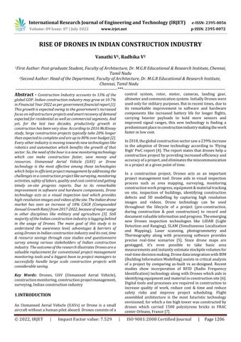
An Unmanned Aerial Vehicle (UAVs) or Drone is a small aircraftwithoutahumanpilotaboard.Dronesconsistsofa
control system, rotor, motor, cameras, landing gear, altimeterandcommunicationsystem.InitiallyDroneswere usedonlyformilitarypurposes.Butinrecenttimes,dueto its remarkable improvement in software and hardware components like increased battery life for longer flights, carrying heavier payloads to hold more sensors and improved signal ranges, this new technology is finding a predominantplaceinconstructionindustrymakingthework fasterinlowcost.
In2018,theglobalconstructionsectorsawa239%increase in the adoption of Drone technology according to ‘Flying High’PwCreport[4].Thereportstatesthatdroneshelpa constructionprojectbyprovidingincreasedefficiencyand accuracyofaproject,andeliminatesthemiscommunication inaprojectatagivenpointoftime.
In a construction project, Drones acts as an important project management tool. Drone aids in visual inspection process such as area mapping, surveying, monitoring constructionworkprogress,equipment&materialtracking on site, inspection of buildings, identifying construction defects and 3D modelling by capturing high resolution images and videos. Drone technology can be used throughout the lifecycle of a project (pre construction, during construction & post construction) to record and documentvaluableinformationandprogress.Theemerging new Drones inspection technologies like LIDAR (Light DetectionandRanging),SLAM(Simultaneous Localization and Mapping), Laser scanning, photogrammetry and Thermography along with processing software provides precise real time scenarios [5]. Since drone maps are geotagged, it’s even possible to take basic area measurementsandinstantlyestimatestockpilevolumesfor real timedecisionmaking.DronedataintegrationwithBIM (BuildingInformationModelling)assistsincriticalanalysis of a project by comparing as built vs as designed. Recent studies show incorporation of RFID (Radio Frequency Identification)technologyalongwithDroneswhichaidsin identifyingequipmentandmaterialinconstructionsite[6]. Digitaltoolsandprocessesarerequiredinconstructionto increase quality of work, reduce cost & time and reduce safety risks and improve project scheduling. Flight assembled architecture is the most futuristic technology envisioned,forwhicha6mhightowerwasconstructedby drones which carried 1500 polystyrene bricks in FRAC centerOrleans,France[7].
International Research Journal of Engineering and Technology (IRJET) e ISSN: 2395 0056
Volume: 09 Issue: 07 | July 2022 www.irjet.net p ISSN: 2395 0072
The term Drones refers to an aircraft that is not manned physicallybyapilotbutworksthroughhumaninvolvement [8].Dronesaremadeoflightweightcompositematerials.It helps in reducing the weight and increasing the manoeuvrability making it easy to fly. Drones can capture from high altitudes. The drones are controlled from the ground. Drones can be controlled remotely, often from a smartphone,tabletorajoystickandGPSsystem.Wireless connectivityhelpsdronetocapturedifferentviews.Theseare designed to absorb vibrations in air. A drone depends on rotorsforitsverticalmotion.Droneshavebuilt incameras onboardthatallowstocaptureimagesandvideoswherethe drone is flying without having a direct line of sight to the device.LandingGearallowDronestosetdownlikebirds[9]. Differenttypesofdronesaremulti rotordrones,singlerotor drones,fixedwingdronesandhybriddrones[10,11].Drones can be selected depending on the usage and its pay load capacity
andcollectphotogrammetryinformation,photos,andvideos ofa20acressite,itwouldtakeapproximately2to4hours andtoprocessthedataitrequires1hourforeveryonehour offlyingtime[15].
2.2.2
Volumetricsisoneofthemostpopularusecasesfordrones on any construction site. Since the entire site can be capturedinacoupleofhoursorless,dronedataservesasan affordablesourceoftimelyandaccurateinformation[16]. Drones helps in calculating stockpile measurements and comparing it to a final grade design file to calculate how muchmaterialneededeitherforcutorfill[17].
(Source:
Fig 1 :PartsofDrone[9]
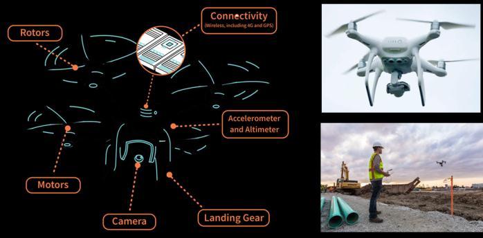
Formanyyears,theconstructionindustryreliedheavilyon professional land surveyors to perform topographical surveyswhicharehighlytimeconsumingandexpensiveasit requiresbulkytools,suchastripods,totalstationsandGSP equipment [10]. In recent years, drone technology has enteredthisspacetoperformtopographicalsurveys[12].By using drones 80% is the time saving and approximately around 30% is the cost saving compared to traditional survey methods [13] . The information extracted from a dronesurveyisalsonearaccuratewithasatisfactoryerror ofbetween1cmforgroundcontrolpointsand4cmforother partsofthesurvey[14].Highresolutionvisualcamerasare the most popular one used in the industry. LIDAR (Light Detection andRanging), SLAM(Simultaneous Localisation and Mapping), Laser scanning, photogrammetry and Thermographyhelpsinsurveying[5].Foradronetosurvey
Theconventional methods ofbuilding inspections require teams to walk across potentially dangerous rooftops and scaffolding[16].Constructionprojectmonitoringisthekey in a project to avoid cost and time over runs and loss of resources.Dronesarebecomingthekeytoolformonitoring sitesasitprovidesreal timedata.Frequentdroneinspection ofconstructionsiteshelpsincheckingthesafetyofworks (whether theyare wearing helmets & PPEsuits etc.)[18], monitoring the material storage area, preventing theft of materials,inspectingthequalityofconstructionworkdone, identifyingthedefectsandmitigatingitinearlystages[10]. Dronesgivemultiplehigh resolutionaerialimagesandhigh qualityvideos,whichhelpsprojectmanagersgettingabetter overview of project progress at daily, weekly or monthly intervalsaiding in thepreparation ofprogress reports for stakeholders[19].
Drones are capable of capturing highly accurate georeferenceddata.TheseDronedatacanbeusedtocreate 3Dmodelswithaccuratepositioninginformationthatcanbe readily fitted into the BIM models to visualize designs to checktheas builtvsas designed[16].Thishelpsinchecking the project time schedules and avoid time over runs and mitigatetherisksbeforeoccurrence.Alotofresearcheshave beenconductedonDronephotogrammetryfor3Dmapping
International Research Journal of Engineering and Technology (IRJET) e ISSN: 2395 0056
and modelling [20]. The 3D model reconstruction is performedusingaregularcamera,andlatercombiningthe photos from different angles. This process is known as monocularphotogrammetry[5].
In a bigger construction site, different equipment will be involvedandvariousmaterialsinhugequantitieswillbeput up in site. Monitoring the equipment and materials is a biggertask.Thisisusuallyaproblemwithalargenumberof differenttablesanddocuments,whichareoftendifficultand time consumingtokeep[19].DronesalongwithRFID(Radio FrequencyIdentification)technologyhelpsineasytracking ofmaterialsandequipmentonsite[6].
drone survey in construction site has helped in enhanced productivityandbetterscheduling[16].
2.4.2
California headquarteredSukutConstructiondecidedtouse Dronesaftertraditionalaerialsurveyingprovedtoocostly andtooslowfortheirfast movingprojectneeds.Theywere ableto save$20,000andalso3weekstimeusingDrones. Thecontourmapwaspreparedwithintwodaysusingthe dronetechnology[16].
2.4.3
Established in 1937, Hensel Phelps is one of the largest generalcontractorsandconstructionmanagersintheUSis anearlyadopterofDronesinconstruction.Foranexterior inspectionofa15 storeybuilding,theyusedtospendalotof moneyinhiringworkerstosetupscaffolding,andthenthe inspectioncrewwoulddotheirjob;whichwouldtakeweeks. But,usingDrones,ittookthemonly4hourstocompletethe flying,8hourstoprocessthedata,andanother4hoursto analyseit.Achieving8xtimesmoreefficiency[16].
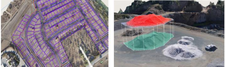
Fig 3c (left): Constructionmonitoringusingdrones, Fig 3d (middle) Droneimages+BIMIntegrationtocheckas builtvsas designed& Fig 3e (right) Assetmonitoringand tracking
(Source:DJI&Propellor ThedronesinConstruction Guidebook)[16]
Assessmentofdamagedconstructionsiteafterafloodoran earthquake is important to plan the first response, rescue andrecovery[21].DronescanhelpingivingHigh Definition imagesandvideosofthedamagedsiteimmediatelyafterthe disasterwhichotherwisewouldtakemoretimeifin person assessmenthastobemadedelayingtherescueplans[22].
There are few barriers involved in Drone technology like security and privacy issues, legal considerations, drone crashes due to bad weather or technical glitch, lack of technical knowledge to operate drones, large capital investmentandairtraffic[5,23 25].
CivilcontractorGradeTechhasregularlyflownDronesonce a week for every active project over the last year. The company estimates that in one year alone, it has saved $250,000 in operational costs and made $1.5 million in additional revenue. Savings in trucking costs, accurate volumetric calculations, or saving in crew days because a
2.4.4
AndhraPradeshRealEstateRegulatoryAuthority(APRERA) and CIDC used drones Real time monitoring of 2,950 constructionprojectsacrossAndhraPradeshresultinginthe employment of 8,850 drone operators in the state. ExtrapolatingthesenumbersforPan India,translatesintoa demandfor1,68,000droneoperatorsformonitoringalone [4].
AmericanSurveying(AAS)surveyed90acresoflandwhich tookonly3daysusingdronetechnologywhichwas6xtimes faster than conventional method (generally would have taken18 22dayswithtraditionalsurveyingmethods)[4].
TheIndiangovernmentisalreadyleveragingthepowerof drone technology in various development programmes. Under the SVAMITVA Scheme (Survey of Villages and Mapping with Improvised Technology in Village Areas) which was launched in April 2020 to help Indian rural residentsestablishclearownershipoftheirproperties.This wasdoneusingDronetechnologybymappinglandparcels which was done within a month. The scheme benefitted morethan6.62lakhvillages,grantingfinancialstabilityto theruralpopulationandenablingthemtousetheirlandto completetransactions/availloans[26].
Productivity in the Indian construction sector is 58% higher than agricultural productivity but it lags behind
Volume: 09 Issue: 07 | July 2022 www.irjet.net p ISSN: 2395 0072 © 2022, IRJET | Impact Factor value: 7.529 | ISO 9001:2008 Certified Journal | Page1208
International Research Journal of Engineering and Technology (IRJET) e ISSN: 2395 0056
Volume: 09 Issue: 07 | July 2022 www.irjet.net p ISSN: 2395 0072
other sectors. Construction sector is one of the major employments generating sector in India that has seen a decline in its productivity over the past few years because of not adopting new technology like other disciplines.Sinceitisalabor intensiveindustry,adopting dronetechnologycanincreaseitsproductivitybysaving cost,timeandresources[22].
Accordingtotherecent‘FlyingHigh’2018reportbythe ECI PwC, the construction sector is expected to employ around2.5lakhdrone operators to be implemented for variousactivities[4].Indiahasoneofthefastestgrowing Dronemarkets.Indiaimportsnearly22.5%oftheworld’s drones. Indian Drone marked is expected to grow at 18% CAGR (Compound Annual Growth Rate) during 2017 to 2023 in terms of revenue and is estimated to reach USD 885.7 million [3, 4, 27] In India on 15th September 2021, under ‘Made in India’ scheme, Union cabinethasannouncedProductionLinkedIncentive(PLI)for drone manufacturers to make India a drone hub by 2030. The PLI scheme will provide up to 20% incentive to manufacturersofdronesanddronecomponentsinIndiaas 90% of the drones are imported as of now. This scheme reinforcesthatdronetechnologywillplayaninevitablerole in Indian construction industry in future [26, 28] [29] if thereisproperawarenessandunderstandingofthisDrone applications.
The study involves extensive and critical review of secondarydatawhichincludesbooks,journals,reports,case examples,governmentpoliciesandnewsarticlesfocusingon drones and its various applications in the Indian constructionindustrywhichisdetailedintheabovetopic.
This study involves detailed questionnaire survey to understand the awareness, application and barriers of drones in Indian Construction Industry. The study populationincluded employeesofL&T,STUPConsultants, fewgovernmentofficials,fewIndependentArchitecturaland constructionfirmsinChennai,Mumbai&Bangalore&Free lancers.RespondentswouldbeArchitects,CivilEngineers, Consultants(MEP/Energy/Financial),Contractors,Clients& ProjectManagers.AccesstotheSamplingFrameisthrough Googleforms&TelephonicInterviews.
Two questionnaire sets were circulated. The first questionnaire had questions pertaining to awareness and understanding of Drone technology. As part of the first survey,asamplesizeof155peoplewasidentifiedfromthe
studypopulationwithmorethan3yearsofworkexperience in Indian construction industry. Out of which 146 valid responses were taken for the final analysis. The second questionnaire was circulated to the identified 56 respondents who had used drones in Indian Construction industryfromthe146validresponses.Thissurveyhelpedin rankingtheapplicationsandbarriersofDronetechnologyin terms of cost, time and resource saving in construction industrywithresearchtoollikeRelativeImportanceIndex (RII).SPSSsoftwarewasusedtoarriveatthefinalresults.
Table 1: RespondentsDemographics(146responses)
Parame ters Description Num ber Percen tage Career Position Architects 66 45.7% Project Managers 13 8.7%
CivilEngineers 28 19.6% Consultants (MEP/Energy/ Others)
26 17.4% Contractor 10 6.5% Client 3 2.2%
Experie ncein Constru ction Industry
3to10years 114 78.3% >10years 32 21.7%
Table 2: Responsestothequestions(146responses) Firstquestionnairesurvey
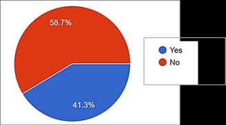
Figure 4: Awarenesson thePLIscheme (ProductionLinked Incentive)for manufacturersofdrone, launchedbyCentral Governmenton15th September2021intheaim ofmakingIndia,aDrone hubby2030.
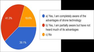
Figure 5: Awarenessof dronetechnologyin constructioninIndian constructionindustry
International Research Journal of Engineering and Technology (IRJET) e ISSN: 2395 0056
Volume: 09 Issue: 07 | July 2022 www.irjet.net p ISSN: 2395 0072
Table 3:Rankingthemostefficientapplicationof dronesin termsofcost,timeandresourcesavingusing SPSSsoftware
(Yes Aware&No Unaware)
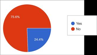
Figure 6:Awarenesson thecapitalinvestmentof drones,itsannual maintenancechargesand pay backperiod
(Yes Aware&No Unaware)
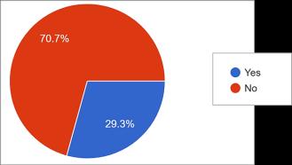
Figure 7: Awarenesson theregistrationand licensingprocessofdrones inIndia?
Total Score (€W) (From56 responde nts)
RII (Relativ e Importa nce Index)
Ranki ng
Site Surveying 164 0.97 1 Volumetric Calculations (cut&fill)
136 0.80 4 Constructio n Monitoring
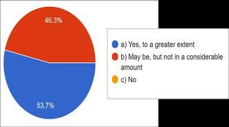
Figure 8: Byusingdrone technologyinconstruction projects,canwesave considerableamountof cost,time&resources (manandmaterial)?
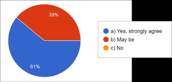
Figure 9: Willdronebethe futuristictechnologythat wouldimprovethequality ofconstructionprojectsby bridgingthegapbetween allinefficienciesina projectlifecycle?
3.2.2.1 Ranking the Application of drones (56 responses) Second questionnaire survey
Thesecondquestionnairesurveyhelpedinrankingthe sixmajorapplicationsofDronesinconstructionindustry in terms of cost, time and resource savings like Site surveying, Volumetric calculation, Construction monitoring,Droneimages+BIMIntegration,Equipment and material tracking on site and Damage assessment afteradisasteratthesite.
RII(RelativeImportance Index)=€W/A*N
A is the highest score (3 in this case)
N is the Total number of Respondents (56)
€W is the Total score of the 56 Respondents
ScoringCriteria: 3 (Most Efficient Application), 2 (Efficient Application), 1 (Not very Impactful).
160 0.95 2 Drone Images+ BIM Integration (tocheckas designedvs as built)
144 0.85 3 Equipment &Material tracking onsite
120 0.71 5 Damage assessment aftera disaster
112 0.66 6 3.2.2.1 Ranking the Application of drones (56 responses) Second questionnaire survey
The second questionnaire survey further helped in rankingthesixmajorbarriersofDronesinconstruction industry from highest risk to lowest risk. The six identifiedmainbarriersarePrivacy,Safetyissueswhile operation, Weather, Legal considerations, Lack of technicalknowledge,largeCapitalinvestment.
RII(RelativeImportance Index)=€W/A*N
A is the highest score (4 in this case)
N is the Total number of Respondents (56)
€W is the Total score of the 56 Respondents
Scoring Criteria: 4 (High Risk), 3 (Medium Risk), 2 (Low Risk), 1 (No Risk)
International Research Journal of Engineering and Technology (IRJET) e ISSN: 2395 0056
Volume: 09 Issue: 07 | July 2022 www.irjet.net p ISSN: 2395 0072
Table 4: Ranking the Barriers of drones in terms of cost, time and resource saving (Highest risk to Lowest risk) using SPSS software
BARRIERS of DRONES
Total Score (€W) (From56 responde nts)
RII (Relativ e Importa nce Index)
Ranki ng
Privacy 180 0.80 2 Safety Issues while operation
172 0.76 3 Weather 148 0.66 4 Legal Considerati ons
Efficient project delivery has been a key challenge in construction industry. With rising project management issues like cost over runs, time over runs and shortage of skilled labor, it is important for innovative monitoring solutions like drone technology (UAV) implemented as a project management tool to solve all in efficiencies in a construction project. The main aim of this comprehensive studyistoshowhowdronetechnologycansavecost,time andresourcesinaconstructionprojectwithcaseexamples andthroughquestionnairesurveyshaveattemptedtostudy theawareness,applicationandbarriersofdronetechnology inIndianConstructionindustry.
196 0.87 1
Lackof Technical knowledge
92 0.41 6
120 0.53 5 Large Capital Investment
The results of the first questionnaire survey helped in understandingtheawarenesslevelofDronetechnologyin Indianconstructionindustry.58.7%respondents(Figure4) wereawareofthePLIschemelaunchedbytheGovernment ofIndiaon15thSeptember2021.Around49.3%(Figure5) respondents were completely aware of Drone technology, 39.1% were partially aware and 19.6% were not aware. Around75%(Figure6)respondentswereunawareofthe capitalinvestment,itsmaintenancecostandpay backperiod of drones. Only 29.3% (Figure 7) were aware of the registrationandlicensingprocessofdronesinIndia.53.7% (Figure8)respondentsagreeddronewillsavecost,timeand resources in a construction project and 61% (Figure 9) respondents opted that drone will be the futuristic technologyinbridgingthein efficienciesinaconstruction project.
The results of second questionnaire survey helped in ranking the major applications and barriers of drones in construction industry. Surveying and Construction monitoringbeingthetwotopratedapplicationsintermsof cost,timeandresourcesavingsandLegalconsiderationsand Privacybeingthetwotopratedbarriersofdrones.
Amongthesamplesstudied,ithasbeenobservedthatthere isagoodlevelofawarenessofdronesinIndianConstruction industrybutlessinterestshowntousethesametechnology. The lack of awareness in initial capital investment, registrationprocessandlegalconsiderationsare themain reasonforlowlevelofusageinIndianconstructionindustry. Dronetechnologycanbeusedthroughouttheconstruction projectlifecycle.Dronedatahaveperfectaccuracyandcan berecordedforfutureuse.Droneinspectionofsiteduring construction helps in identifying the risks earlier and mitigating it with proper plan. Because of regular monitoring,re workcostandtimeisconsiderablyreduced oravoided.Projectreportcanbemadeeasilywitheveryday projectprogresshighqualityphotos fromdronetripsand checkas designedvsas builtwiththeBIMmodel.Byproper equipment tracking and monitoring of equipment and materialsonsite,theftandsitecongestioncanbeprevented. Drones engaged safety monitoring helps preventing fatal accidentsinsite.Hencedroneisaninevitableneedinlarge scaleconstructionprojects.
Central Government projects have already started using Dronetechnology(eg.StatueofUnity,LightHouseProjects etc.) [30, 31]. Private construction companies and firms should involve this drone technology which would cost approximately 8 12 lakhs Indian Rupees including hardware, software and licensing fee with an annual maintenanceof2 3lakhsIndianRupees[15]buthasagood pay backperiodresultinginmoreoftangibleandintangible benefits.NHAI(NationalHighwayAuthorityofIndia)inJuly 2021hadmadeDronemonitoringmandatoryforallfuture highway projects for monitoring different stages of development,construction,operationandmaintenance.The collecteddronevideosofeachhighwayprojectwillbesaved onNHAI’sportal“DataLake”toassesstheprogressmadeon theprojects[32].AwarenessonthePLIschemeshouldbe created among the Indian Construction Industry stakeholderssotheyunderstandtheReturnonInvestment (ROI) of drones which is more beneficial at the end of a project. Still more training and awareness needed on the licensingofdrones,technicalknowledgetooperateandits safety norms among the stakeholders to appreciate its
2022, IRJET | Impact Factor value: 7.529 | ISO 9001:2008 Certified Journal |
International Research Journal of Engineering and Technology (IRJET) e ISSN: 2395 0056
Volume: 09 Issue: 07 | July 2022 www.irjet.net p ISSN: 2395 0072
advantages.ItcanbeconcludedthatDronesaregoingtobe the much needed technology which will bridge all the inefficienciesinaconstructionprojectandactasaneffective projectmanagementtool.
Few seminars and workshops can be conducted by government and private sectors on Drone applications & India’s drone related policies which includes the PLI schemes, licensing process of drones, DGCA (Directorate GeneralofCivilAviation)approvals,legalconsiderationsand obtainingdroneoperatorspermit[4,23,33].Thiswillhelp in increasing the usage of drones in Indian construction industry as still the stakeholders are concerned about the safetyandlegalissuesofusingdroneswhichisinferredfrom thesamplesstudied.
1. Indian construction GDP. 2022; Available from: https://www.moneycontrol.com/news/business/r eal estate/construction sector expected to witness double digit growth of 10 7 in fy22 govt 7912591.html.
2. Mckinsey Report 2016. Available from: https://www.mckinsey.com/business functions/operations/our insights/imagining constructions digital future
3. Indian Drone market. Available from: https://www.6wresearch.com/industry report/india unmanned aerial vehicle uav market 2017 2023 forecast by types by uav range applications regions competitive landscape#
4. Report,P., Flying High. 2018.
5. Israr, A., et al., Internet of Things (IoT) Enabled Unmanned Aerial Vehicles for the Inspection of Construction Sites: A Vision and Future Directions. MathematicalProblemsinEngineering,2021. 2021: p.9931112.
6. Hubbard, B., et al. Feasibility Study of UAV use for RFIDMaterialTrackingonConstructionSites.2015.
7. Fan,J.andM.Saadeghvaziri, Applications of Drones in Infrastructures: Challenges and Opportunities 2019.
8. Irizarry, J., M. Gheisari, and B.N. Walker, Usability AssessmentofDroneTechnologyasSafetyInspection Tools. ElectronicJournalofInformationTechnology inConstruction,2012. 17:p.194 212.
9. Working Principles of drones. Available from: https://www.re thinkingthefuture.com/technology architecture/a2327 how can drones help architects in the future/
10. Li, Y. and C. Liu, Applications of multirotor drone technologies in construction management. InternationalJournalofConstructionManagement, 2018. 19:p.1 12.
11. Types of drones. Available from: https://electricalfundablog.com/drones unmanned aerial vehicles uavs/.
12. Musonda, I. and N. Pillay, Using UAV’s and BIM integration to improve infrastructure delivery A case of Gauteng Department of Infrastructure Development, South Africa.2019.
13. Dronedeploy. Available from: https://www.dronedeploy.com/resources/stories/ top enr firm brasfield and gorrie evolved their drone program/
14. El Meouche, R., et al., UAV PHOTOGRAMMETRY IMPLEMENTATIONTOENHANCELANDSURVEYING, COMPARISONSANDPOSSIBILITIES.Vol.XLII 2/W2. 2016.
15. Tal, D.a. and J.a. Altschuld, Drone technology in architecture, engineering and construction : a strategicguidetounmannedaerialvehicleoperation and implementation.1sted.
16. DJI,P., The Drones inConstructionGuidebook. 2020.
17. Volumetric calculation. Available from: https://www.propelleraero.com/blog/how stockpile volume measurement works in drone surveying with propeller/
18. Gheisari,M.,J.Irizarry,andB.Walker, UAS4SAFETY: The Potential of Unmanned Aerial Systems for Construction Safety Applications.2014.1801 1810.
19. Tkáč,M.andP.Mesároš, Utilizing drone technology in the civil engineering. SelectedScientificPapers JournalofCivilEngineering,2019. 14:p.27 37.
20. Kaamin,M.,etal., The Application Of Micro UAV In Construction Project. Malaysian Construction ResearchJournal,2018. 2
21. Ye,S.,etal., AutomatedDetectionofDamagedAreas after Hurricane Sandy using Aerial Color Images 2014.1796 1803.
© 2022, IRJET | Impact Factor value: 7.529 | ISO 9001:2008 Certified Journal |
International Research Journal of Engineering and Technology (IRJET) e ISSN: 2395 0056
22. Dastgheibifard¹, S. and M. Asnafi, A Review on Potential Applications of Unmanned Aerial Vehicle for Construction Industry. 2018.
23. Charlesraj,V.P.andR.Nijalingamurthy, Stakeholder Perspectives on the Adoption of Drones in Construction Projects.2020.
24. Tatum, M.C. and J. Liu, Unmanned Aircraft System Applications in Construction. ProcediaEngineering, 2017. 196:p.167 175.
25. Albeaino, G. and M. Gheisari, Trends, Benefits, and Barriers of Unmanned Aerial Systems in the Construction Industry: A Survey Study in the United States. Journal of Information Technology in Construction,2021. 26:p.84 111.
26. India Brand Equity Foundation. Available from: https://www.ibef.org/blogs/indian drone industry reaching the skies
27. Indian Drone market need. Available from: https://info.cecr.in/drones in indian construction industry/.
28. India Brand Equity Foundation.
29. PLI Scheme. Available from: https://pib.gov.in/PressReleaseIframePage.aspx?P RID=1755157
30. Statue of Unity
31. Light House Project. Available from: https://timesofindia.indiatimes.com/india/drones used for live review of new tech housing projects by pm companies commit to complete them before time/articleshow/84102584.cms
32. NHAI Drone monitoring. Available from: https://www.thehindu.com/news/national/use of drones mandatory for nhai projects/article34831893.ece
33. UIN. Available from: https://www.pwc.in/industries/financial services/fintech/fintech insights/data on wings a close look at drones in india.html.
Volume: 09 Issue: 07 | July 2022 www.irjet.net p ISSN: 2395 0072 © 2022, IRJET | Impact Factor value: 7.529 | ISO 9001:2008 Certified Journal