International Research Journal of Engineering and Technology (IRJET)
e-ISSN: 2395-0056
Volume: 09 Issue: 07 | July 2022
p-ISSN: 2395-0072
www.irjet.net
IMPACTS OF FLASH FLOOD CAUSED BY THE FAILURE OF THENMALA DAM Jose K George1, Ajay P Krishnadas2, Devika Das2, Elizebeth K Biju2, Sonu V Sabu2 1Professor,
Department of Civil Engineering, Mar Athanasius College of Engineering, Kothamangalam, Kerala, India 2 UG Scholars, Department Of Civil Engineering, Mar Athanasius College of Engineering, Kothamangalam, Kerala, India ---------------------------------------------------------------------***---------------------------------------------------------------------
Abstract -Dam failure leads to the creation of flood
different locations in the downstream area of the dam.
waves which is disastrous to the properties and habitats downstream. Predicting the consequences of the disaster is the primary step for calculating the mitigation measures. This project aims to conduct a dam break analysis of the Thenmala dam using HEC-RAS to find inundation maps showing the depth, velocity of discharge and water surface elevations of different locations within the vicinity of the dam breach. The downstream areas being heavily populated emphasizes the need of predicting the consequences of dam break. Key Words: discharge
2. METHODOLOGY The input data are
DEM file River basin map Dam structural data Inflow data.
The study constitutes two main parts:
flood, dam-break, inundation, breach,
1. INTRODUCTION
Pre-processing of DEM. Dam break analysis and simulation of the flash flood using HEC-RAS.
2.1 DEM PREPROCESSING
Dams provide society with essential benefits such as water supply, flood control and hydroelectric power. The major reasons for dam failure are breaching due to flooding, overtopping failure, seepage failures and structural failures. A recent study conducted by the Indian government has observed that more than 600 dams in the country are located in high-intensity seismic zones. The Thenmala dam was commissioned on the year of 1986 and is a part of the Kallada irrigation and tree crop development scheme and is the largest irrigation project in the state. DEM file which is the primary input data is pre-processed using ArcGIS software. HEC-RAS (Hydrologic Engineering Centre River Analysis software) is used for modelling and analysis of the flash flood. For this study overtopping is considered the primary mode of failure.
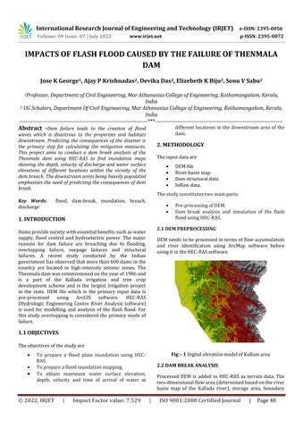
DEM needs to be processed in terms of flow accumulation and river identification using ArcMap software before using it in the HEC-RAS software.
1.1 OBJECTIVES The objectives of the study are
Fig – 1 Digital elevation model of Kollam area
To prepare a flood plain inundation using HECRAS. To prepare a flood inundation mapping. To obtain maximum water surface elevation, depth, velocity and time of arrival of water at
© 2022, IRJET
|
Impact Factor value: 7.529
2.2 DAM BREAK ANALYSIS Processed DEM is added to HEC-RAS as terrain data. The two-dimensional flow area (determined based on the river basin map of the Kallada river), storage area, boundary
|
ISO 9001:2008 Certified Journal
|
Page 48