International Research Journal of Engineering and Technology (IRJET) e ISSN:2395 0056

Volume: 09 Issue: 06 | June 2022 www.irjet.net p ISSN:2395 0072
International Research Journal of Engineering and Technology (IRJET) e ISSN:2395 0056
Volume: 09 Issue: 06 | June 2022 www.irjet.net p ISSN:2395 0072
¹M. Tech Student, Remote Sensing Applications Centre, Uttar Pradesh, India ² Scientist SE & Head, Geospatial Data Division, Remote Sensing Applications Centre, Uttar Pradesh, India ³ Scientist SE & Head , School of Geoinformatics, Remote Sensing Applications Centre, Uttar Pradesh, India ***
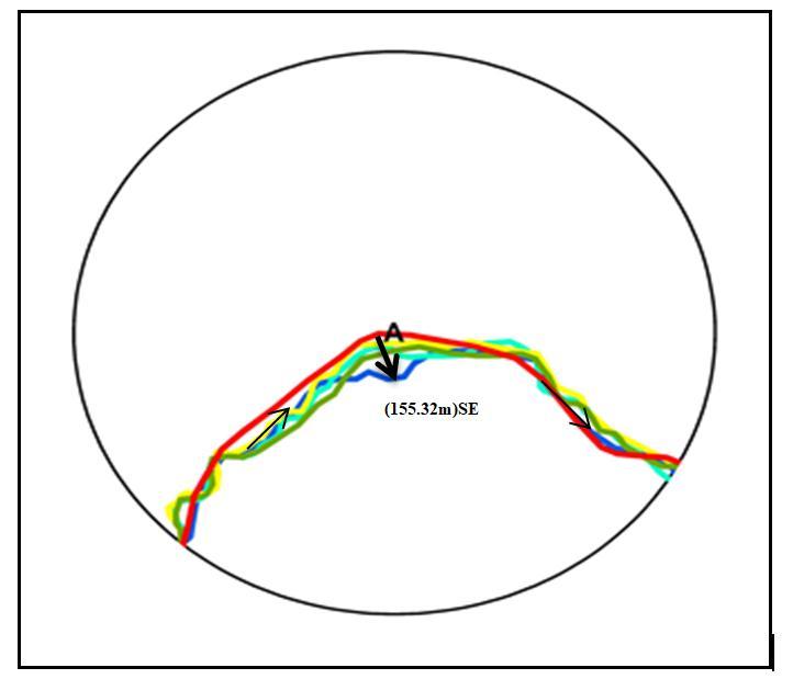
Dynamics of river channel are natural autogenic occurrences for fluvial system with influences from modification of some climatic and geological factors. Remote Sensing and GIS tools and techniques have been used to analyze epochal channel dynamics of river. There are six reaches with in a 242 km Pandu river stretch were studied and analyzed by comparing sequential migratory changes of the river channel during 1975 2000, 2000 2013,2013 2015,2015 2020 and 1975 2020 epochs. Manual and automatic digital processing procedures and Geographical Information System were implemented to visualize and quantify the reach wise spatial and temporal morphological changes. The present study concluded that some major changes in migration in Pandu river. With the help of temporal monitoring some of the places have been identified at which were river highly migrated. There were six migratory points observed. At point C shows multi direction migration in river channel. This point C is situated in Mavaiya village, which is affected by migration at four different channels and it is migrated in multi direction. C1 64.65m in SW, C2 84 m in SE direction from 1975 2020, C3 73.61m in upward NE direction from 1975 2013 and C4 65.47m in downward South direction from 1975to 2020. These are drastic changes in Pandu river at Mavaiya village. The study period were observed and quantified at all reaches. Meandering and the switching off the main active channel were also illustrated. The information is important and necessary for understanding river modification characteristics and aid in planning and management at the lower reaches which has remained poorly understood. Use of remote sensing data in conjunction with GIS provides efficient and economical quantitative spatial and temporal analysis of river channel behavior in Pandu river
Key words-, Remote Sensing and Geographical information System, epochal changes, Morphological changes, Switching off, Meandering.
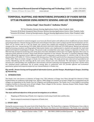
The Pandu river also known as tributary of Ganga river. This tributary of Ganga river flows through five districts of Uttar PradeshbeforeitsconfluencewithGangariver.Approx.2000villagesaresituatedonitsbank.Villagesaresopopulatedandall villagersaredependentonthePanduriverforirrigationand drinkingpurposes.ThePanduriverisveryhelpfulinproviding irrigation facilities to thousand acres of land villages .These villagers of the Auraiya , Kannauj, Kanpur Dehat, Kanpur Nagar andFatehpur fivedistrictsofUttarPradesh.
The main and broad objectives of the present investigation are as follows:
• MappingandMonitoringofPandurivermigratorytrendusingofmulti datesatellitedata.
• Specio temporalassessmentofmigrationofPanduriver.
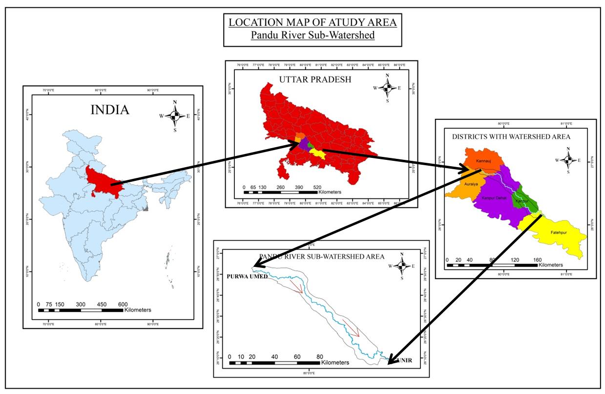
Duringthemonsoonseason,thewaterlevelofthePanduRiverrises.ThePanduRiveroriginates120kilometersfromalakein PurwaUmedVillageandflowsthroughfivedistricts.The Pandu riverflowsover242kilometers.ThePandu riverwatershed
International Research Journal of Engineering and Technology (IRJET) e ISSN:2395 0056 Volume: 09 Issue: 06 | June 2022 www.irjet.net p ISSN:2395 0072
has a total area of 1721.3 hectares. At Gunir village in Fatehpur district, the Pandu river merges with the Ganga to form the Ganga.IntheUttarPradeshdistrictofFatehpur,theKanauj,Auraiya,Kanpurdehat, KanpurNagar,andeventuallytheGanga merge.ThePanduriverstretch,whichrunsbetweenlatitudes26°52'38.77"Nand26°9'50.08"Nandlongitudes79°32'31.68"E to80°35'49.03"Eandcoversfivedistrictsintheresearch,istheinterestofthearea(IOA)underinvestigation.
Fig 1: Location Map
International Research Journal of Engineering and Technology (IRJET) e ISSN:2395 0056
Volume: 09 Issue: 06 | June 2022 www.irjet.net p ISSN:2395 0072
International Research Journal of Engineering and Technology (IRJET) e ISSN:2395 0056
Volume: 09 Issue: 06 | June 2022 www.irjet.net p ISSN:2395 0072
Theinformationregardingthestudyareafortheyear1975wasextracted byusingSOI toposheetsacquiredfromtheNakshe portal,whicharepublishedbytheSurveyofIndiaatascaleof1:50,000.TheUniversalTransverseMercator projectionsystem in the world Georeference System (WGS84) data was used to georeference the toposheets. The Earth Explorer (https://earthexplorer.usgs.gov/) was used to download Landsat 8 (TM/OLI) satellite data for 2010, 2013, 2015, and 2020. We were able to identify the changes in the course of the river channel from 1975 to 2020 by overlaying different layers of riverchannelfromvariousyears,andwewereabletopinpointthelocationswherethe riverchannelmigrateddrastically.In thisriverchannelsearch,atotalof6locationsdemonstratesignificantmigrationinthestudyarea
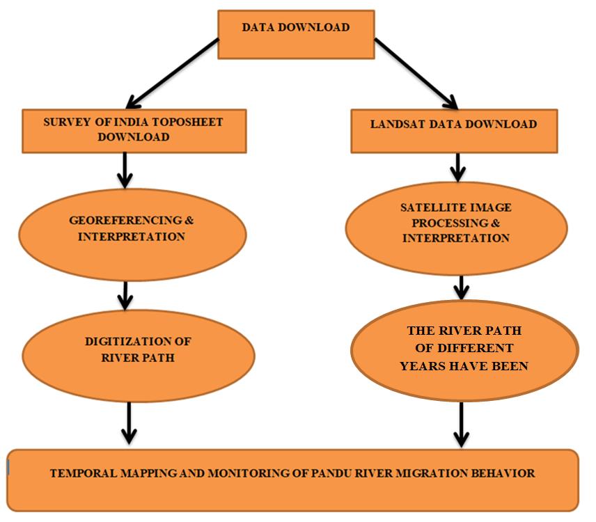
Differentwaysformappingandmonitoring ofrivermigrationshavebeenincludedinthepresentstudy.Figure3depictsthe methodology workflowusedinthisresearch. Fig -3: Flow diagram of methodology
International Research Journal of Engineering and Technology (IRJET) e ISSN:2395 0056 Volume: 09 Issue: 06 | June 2022 www.irjet.net p ISSN:2395 0072
The map depicts the evolution of river configuration from 1975 to 2020. Several times during these years, the river channel has changed. According to the findings of this study, there have been significant changes in migration patterns in the Pandu River.Someofthesiteswhererivermigrationwasextremelymigratorywerefoundusing temporalmonitoring.Sixmigratory pointswereidentified A,B,C,D,EandF.Rivermigrationcanwreakhavoconlivelihoodsalongitspath.
International Research Journal of Engineering and Technology (IRJET) e ISSN:2395 0056
Volume: 09 Issue: 06 | June 2022 www.irjet.net p ISSN:2395 0072
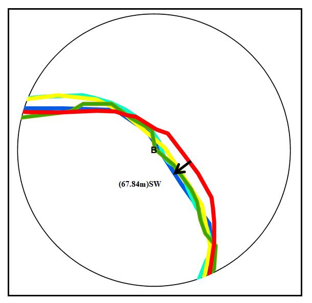
At point A, the river path shifted around 155.38 meters in a south east direction from 1975 to 2020. Point A is located near BhadauravillageinAuraiya district.TherearemanyagriculturalfieldspresentatA pointandtheseagriculturefieldswillbe affectedinthenearfutureifthemigratorytrendcontinues.
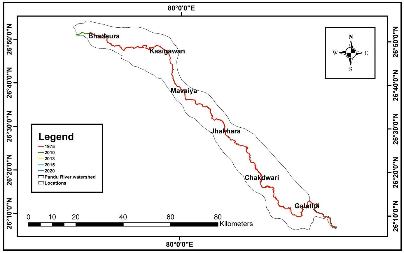
At Point B, the river path shifted around 67.84 meters From 1975 to 2020, the migratory trend at point B was toward the Southeast. Point B is located between Kherwa and Kasigawan villages near the boarder of Kanpur dehat and Kanpur Nagar districts.AtthispointofthePanduriver,thereisalotofagriculturefertilelandpresent.IfthePanduriverchannelmigratesin thefuture,therewillbechancesofsoilerosionanddamageofagricultureland
International Research Journal of Engineering and Technology (IRJET) e ISSN:2395 0056 Volume: 09 Issue: 06 | June 2022 www.irjet.net p ISSN:2395 0072
Atpoint C,theriverchannelshowsmigrationinmulti direction.ThispointCislocatedinMavaiyavillageneartheboarderof Kanpurnagar,whichisimpactedbyfourseparatemigrationpathwaysandismigratedinmanydirections.From1975to2020, C1was64.65mintheSouthwest,C2was84mintheSoutheast,C3was73.6mintheupwardNortheastdirectionfrom1975to 2013, and C4 was 65.47m in the downward South direction from 1975 to 2020. At Mavaiya village, the Pandu River has undergone significant alterations. If the channel continues to migrate in the same direction, it will have an impact on agriculturalareas.
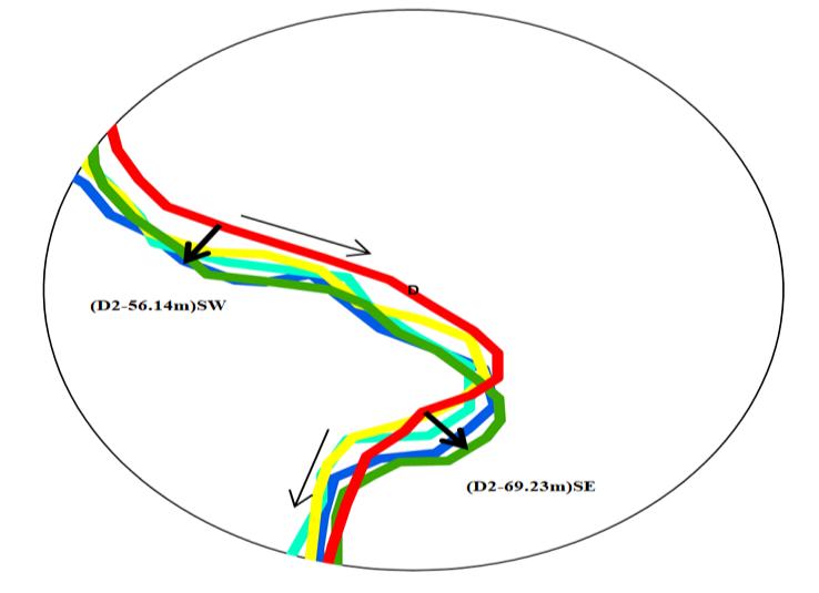
AtpointD,D1andD2,theriverchannelmovedintwosub points.riverchannelalteredaround69.23meterstothesouthwest at subp oint D1 during 1975 to 2010, then migrated back to the southeast at sub point D2. The river channel shifted 56.14 meters to the southeast at sub point D2 from 1975 to 2020. This point is adjacent to the settlement of Jhakhara in Kanpur nagardistrict.Iftheriverchannelcontinuestomigrateinasoutheasterlydirectionat sub point D2,itwillhaveanimpacton thesettlementsandcertainagriculturalareasoneithersideofthePanduRiver'schannel.
International Research Journal of Engineering and Technology (IRJET) e ISSN:2395 0056
Volume: 09 Issue: 06 | June 2022 www.irjet.net p ISSN:2395 0072
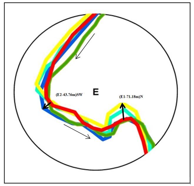
At point E, the Pandu river channel has migrated into two sub points, E1 and E2. From 1975 to 2013, the river channel migrated at Sub point E1 71.18 meters towards the north direction, and afterward, it migrated at Sub point E2 about 43.76 meters towards the south west direction from 1975 to 2020. Point E is situated near Chakdwari village in Kanpur district. Thereisanagriculturalareapresentonbothsidesoftheriverbank.Ifmigrationisnotundercontrol,thentherewillbemore chancesofsoilerosion.Andsoilerosionwillaffectallagriculturallandthatissituatedontheriverbank
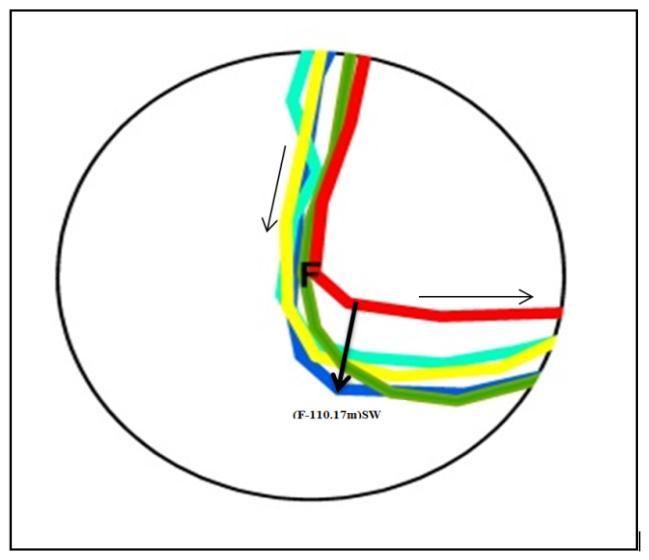
At point F, the river path shifted around 110.17 meters in a south west direction from 1975 to 2020. Poin F is located near Galatha village in Fatehpur district. There are some agricultural fields present at F point and these agricultural fields will be affectedinthenearfutureifthemigratorytrendcontinues.
International Research Journal of Engineering and Technology (IRJET) e ISSN:2395 0056
Volume: 09 Issue: 06 | June 2022 www.irjet.net p ISSN:2395 0072
The present investigation concluded that if the river channel migrates drastically, bank erosion will increase which affecting settlements and fertile agricultural land. Between 1975 and 2020, it was effectively observed as a meandering shape near Mavaiya,Jhakhara,Chakdwari,andGalatha villages,resultingintheloss of agricultural landandhabitation life andproperty space.
Furthermore, geomorphic features such as ox bow lakes, cutoff meanders, paleochannels, and abandoned river channelsmightalterthelandscapeinthefuture.
Most of the migration of the river channels has been observed near Mavaiya about at C2 84 meters towards the south west direction, Chakdwari at E1 71.18 meters in the north direction, and Galatha atpoint F 110.17 meters in the south east directioninrespectivelyvillages,andduringthelast38to45years,accordingtothisstudybasedonriverchannelmigration.
Dhari,S.,Arya,D.S.,andMurumkar,A.R.,(2015).ApplicationofremotesensingandGISinsinuosityandrivershifting analysisoftheGangesRiverinUttarakhandplains.AppliedGeomatics,7(1),13 21.
Glantz,M.H.Water,climate,anddevelopmentissuesintheamudaryabasin.MitigationandAdaptationStrategiesfor GlobalChange2005,10,23 50
Hedge, M., Mathur, V. K. and Mandal, P. S. (1989), Erratic meander shift of the river Ganga at Kanpur. In Proc. Third InternationalWork shoponAlluvialRiverProblems,OxfordandIBH,NewDelhi,Vol1,pp.239 246.
J.D.DasandA.K.Saraf,(2007)“RemoteSensingintheMappingoftheBrahmaputra/JamunaRiverChannelPatterns and Its Relation to Various Landforms and Tectonic Environment,” International Journal of Remote Sensing, Vol. 28, No.16,pp.3619 3631
J. N. Sarma, D. Borah and U. Goswami, (2007) “Change of River Channel and Bank Erosion of the Burhi Dihing River (Assam),AssessedUsingRemoteSensingDataandGIS,”JournalofIndianSocietyofRemoteSensing,Vol.35,No.1,pp. 94 100.
Kumar,L.;Mutanga,O.Googleearthengineapplicationssinceinception:Usage,trends,andpotential.RemoteSensing 2018,10,1509.
L.Bhakal,B.DubeyandA.K.Sarma,(2005)“EstimationofBankErosionintheRiverBrahmaputranearAgyathuriby UsingGeographicInformationSystem,”JournalofIndianSocietyofRemoteSensing,Vol.33,No.1,pp.81 84.